Abandoned & Little-Known Airfields:
Pennsylvania: Southern Philadelphia area
© 2002, © 2025 by Paul Freeman. Revised 10/29/25.
This site covers airfields in all 50 states: Click here for the site's main menu.
____________________________________________________
Please consider a financial contribution to support the continued growth & operation of this site.
____________________________________________________
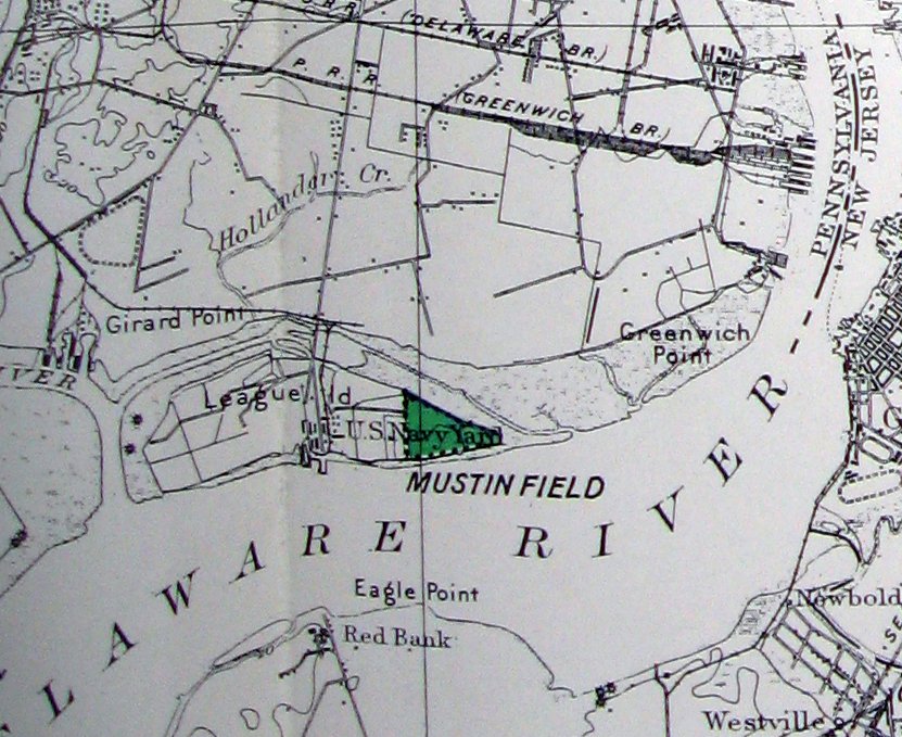
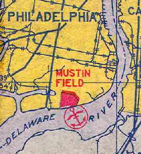
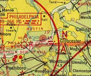
Philadelphia Navy Yard Field / Henry C. Mustin Naval Air Facility (KMUV),
Philadelphia Naval Shipyard, PA
39.89, -75.158 (Northeast of Philadelphia International Airport, PA)
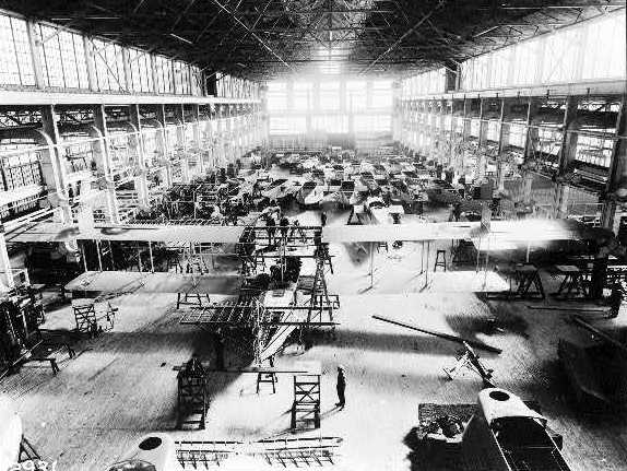
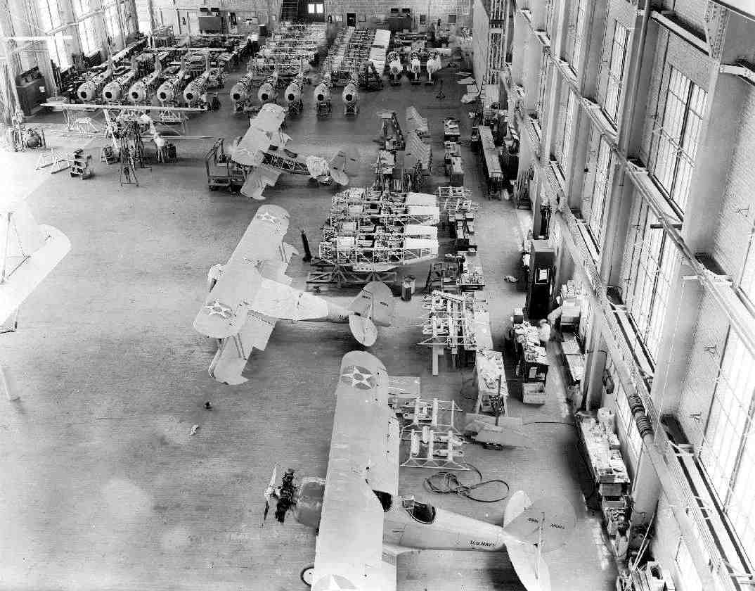
A 1917 photo of the Naval Aircraft Factory assembly line for unidentified biplane flying boats.
The Philadelphia Navy Yard was established in 1801 on League Island in the Delaware River in Philadelphia.
On 7/27/17, Secretary of the Navy Josephus Daniels approved the development of a Naval Aircraft Factory
to assist in solving the problem of aircraft supply which faced the Navy Department upon the entry of the U.S. into World War I.
The Army’s requirements for an enormous quantity of planes
created a decided lack of interest among aircraft manufacturers in the Navy's requirements for a comparatively small quantity of aircraft.
The Navy Department concluded that it was necessary to build a Navy-owned aircraft factory in order to assure a part of its aircraft supply,
to obtain cost data for the Department’s guidance in its dealings with private manufacturers
and to have under its own control a factory capable of producing experimental designs.
The contract to build the Naval Aircraft Factory on the grounds of the Philadelphia Navy Yard was let on August 6, 1917,
and ground was broken 4 days later.
The entire plant was completed by 11/28/17, only 110 days after ground-breaking.
When the Naval Aircraft Factory was completed the greatest need was for patrol flying boats, so production of the H-16 patrol aircraft was started.
On 3/27/18, just 228 days after ground-breaking & 151 days from receipt of drawings,
the first H-16 built by the NAF was successfully flown.
On the following April 2 the first 2 NAF-built H-16s were shipped to the patrol station at Killingholme, England.
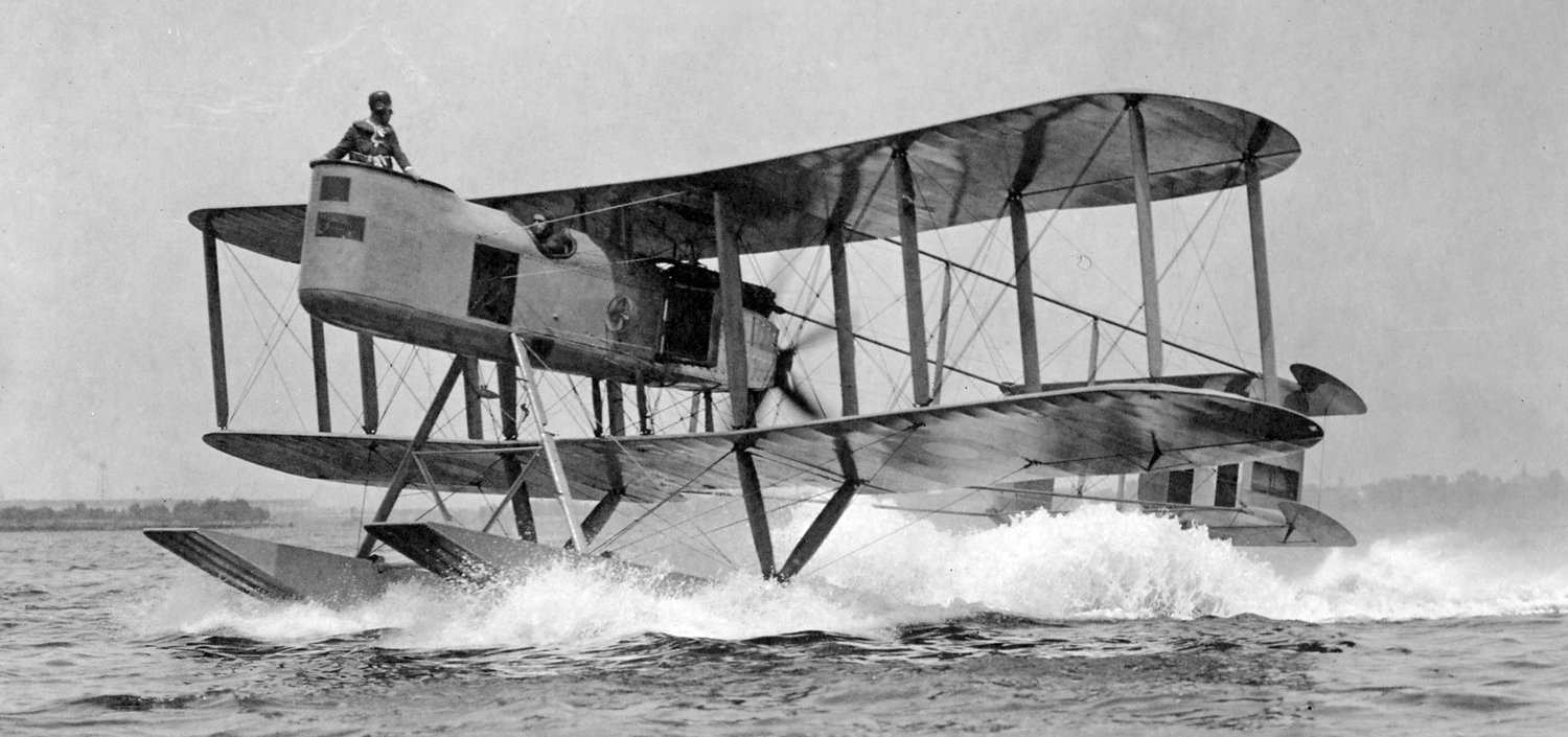
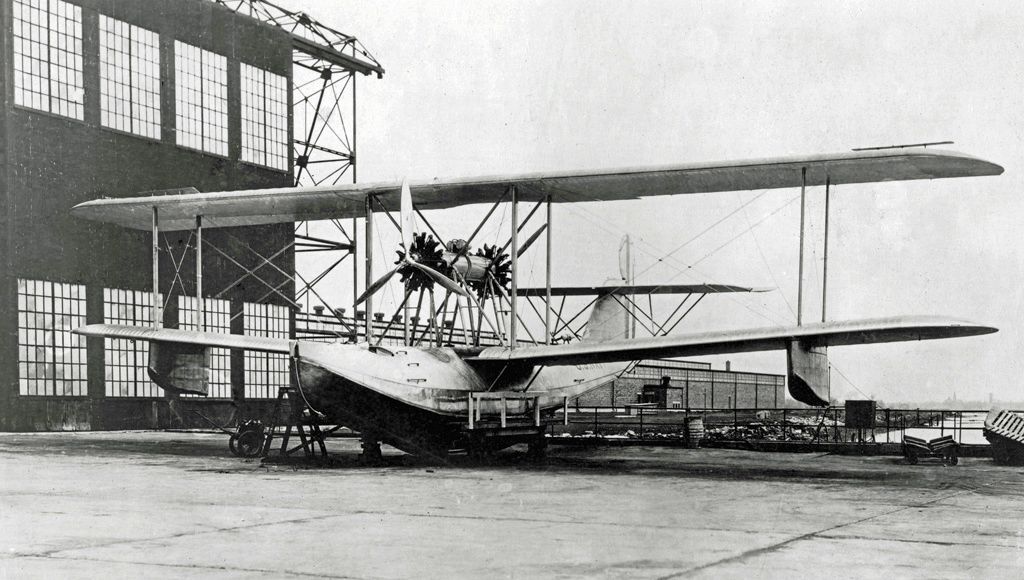
A 5/24/18 photo (from the National Archives) of the first prototype Naval Air Factory N-1 floatplane, A2282, conducting a test run from the Philadelphia Naval Aircraft Factory.
This first N-1 crashed before getting airborne. It was also known as the Davis Gun Carrier on account of the heavy caliber gun with which it was intended to be fitted.
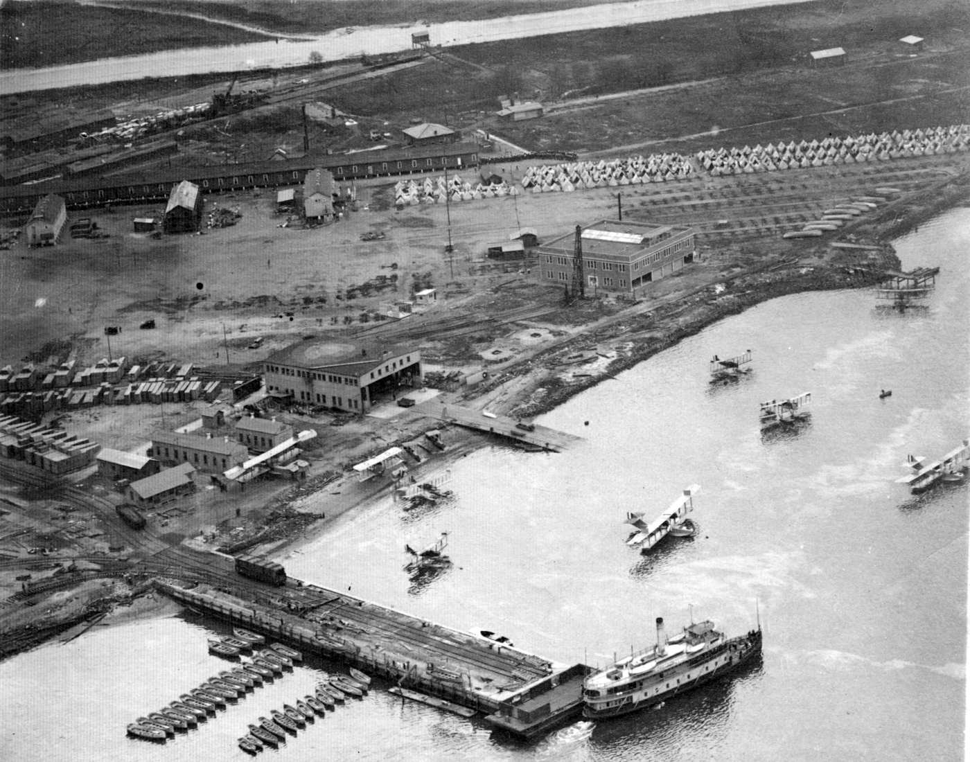
An 11/14/18 aerial view looking northeast at the seaplane hangar & launching ramp of the Philadelphia Naval Aircraft Factory (from the collection of Alvin Knobloch, courtesy of Robert Lewis)
showing a total of 9 biplane flying boats & seaplanes.
After World War I, the Philadelphia Naval Air Factory served as a research & development to support the Navy's new air arm.
It built prototype aircraft & produced small production lots of aircraft.

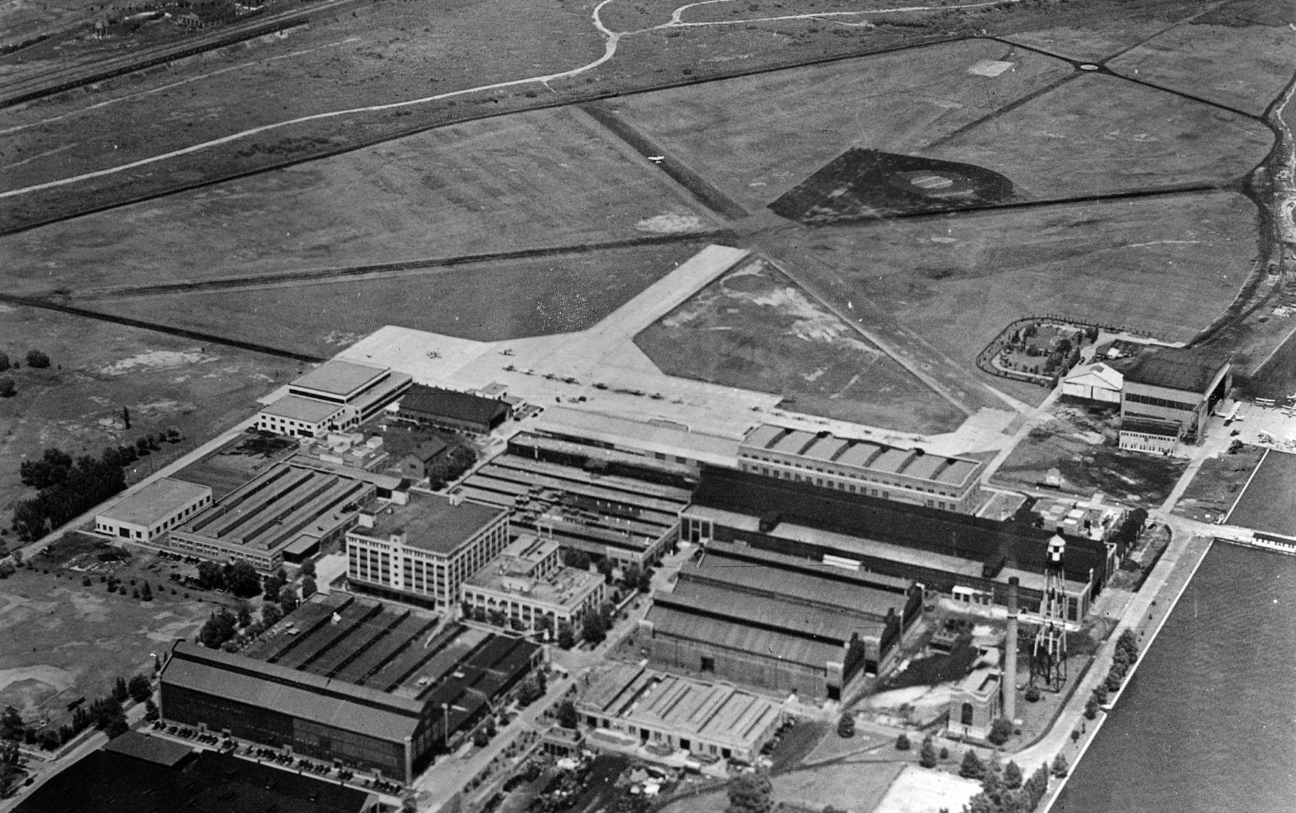
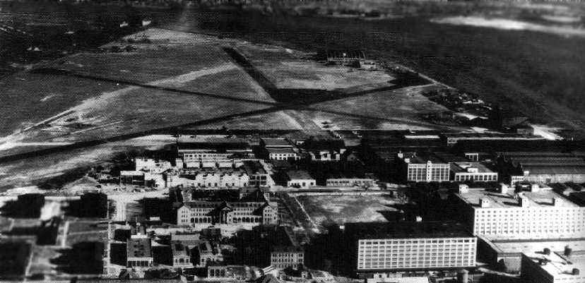
A 1924 aerial view looking northeast at the Philadelphia Navy Yard Field, with the large building marked “Naval Aircraft Factory” along the river.

A 10/14/1926 photo of a beautiful Curtiss R3C floatplane racer at the Philadelphia Naval Airplane Factory.
The factory acquired its own landplane airfield, Mustin Field, in 1926, along with 2 large hangars.
Mustin Field was named after Henry Mustin, the first pilot launched off an American ship.
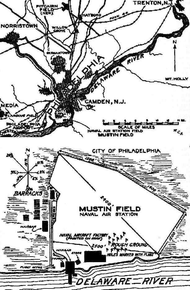
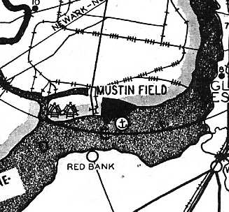
The location & layout of Mustin Field Naval Air Station, as depicted on the 1927 Department of Commerce Airway Bulletin (courtesy of David Brooks).
It described Mustin as a sod field measuring 2,500' east/west,
with 3 hangars along the southwest & south sides, and the Naval Aircraft Factory on the south side.
Mustin Field, as depicted in a 1928 report “Location of Airport, Philadelphia” (courtesy of Fred Kelso).
The earliest aeronautical chart depiction which has been located of Mustin Field
was on the 1929 Washington – New York City Air Navigation Map #3.
A 1930 Dallin Aerial Survey Company aerial view depicted Mustin Field as an irregularly-shaped unpaved area
with the Naval Aircraft Factory building along the south side (with “US Navy Yard, Naval Aircraft Factory” painted on the roof).
Mustin Field, as depicted on the Philly Chamber of Commerce's
1930 "Aviation Map of the Philadelphia Metro District" (courtesy of Tom Beamer).
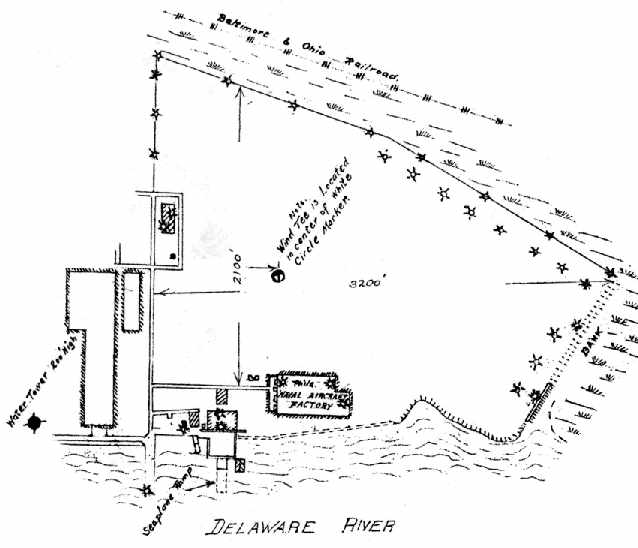
The airfield layout of Mustin Field from the 1930 book "Philadelphia Aeronautical Center of the East"
(courtesy of the George H. Stuebing Collection of the Delaware Valley Historical Aircraft Association).
The directory described the field as consisting of a 135 acre sod field,
measuring 3,200' east/west by 2,100' north/south.
The Philadelphia Naval Aircraft Factory was depicted on the south side of the field,
which was also said to have 4 hangars.

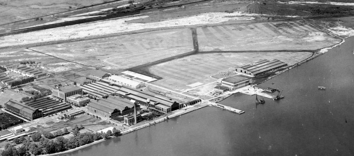
An aerial photo looking west at Mustin Field from the 1930 book "Philadelphia Aeronautical Center of the East"
(courtesy of the George H. Stuebing Collection of the Delaware Valley Historical Aircraft Association).
The field was depicted as an open grass field with buildings along the west & south sides.
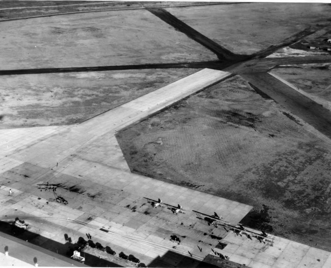
A 1931 aerial view looking northeast at Mustin Field (courtesy of David Kearny), showing the airfield to have 3 asphalt runways in a “Y” shape.
Large factory buildings were visible at the bottom-left,
along with a large building on the south side of the runways which does not appear in later photos.
The airfield area was smaller than that depicted in later photos (apparently more land was filled in eventually on the east side of the airfield).
The earliest Sectional Chart depiction which has been located of Mustin Field was on the May 1932 Washington Sectional Chart.
Mustin Field, as depicted on the 1934 U.S. Navy Aviation Chart (courtesy of Chris Kennedy).
The 1934 Department of Commerce Airport Directory (according to Chris Kennedy)
described "Mustin Field - Navy" as having 3 cinder runways, with the longest being a 2,900' northwest/southeast strip.
A hangar was said to have "Naval Aircraft Factory" painted on the roof.
A circa mid-1930s USN aerial view looking northeast at Mustin Field, showing the airfield to have 3 asphalt runways.
A significant number of landplanes were visible on the ramp, along with seaplanes on the seaplane ramp.
A 12/5/36 aerial view looking northeast at 7 biplanes (of at least 2 different unidentified types) on Mustin's ramp.
A 6/28/37 U.S. Navy photo of the N3N biplane assembly line in the Philadelphia Naval Aircraft Factory.
The Airport Directory Company's 1937 Airports Directory (courtesy of Bob Rambo)
described Mustin Field as having a total of 3 cindered runways,
with the longest being a 2,900' northwest/southeast strip.
The hangar was described as having "Naval Aircraft Factory" painted on the roof.
Mustin Field, as depicted on the 1940 Washington Sectional Chart (courtesy of Mike Keefe).
A 1940 aerial view of Philadelphia had the area of Mustin Field censored, ostensibly due to pre-WW2 security concerns.
During WW2, the Naval Aircraft Factory devoted considerable effort developing improvements to the Navy's PBY Catalina flying boat.
During 1940 the Naval Aircraft Factory developed several worthwhile hydrodynamic & aerodynamic modifications for the plane,
but these couldn't be incorporated without stopping Consolidated's production lines
and slowing much-needed deliveries of the current model.
So the Navy took a different tack: on 7/16/41
an order for 156 modified PBY-5s went to the Naval Aircraft Factory itself.
The NAF version, designated PBN-1 Nomad, featured a longer hull (64' 8”),
a sharper bow, a 20% taper step amidships, and a shallow breaker step just forward of the tail.
Wingtip floats were redesigned for more lift & improved planing.
More fuel tanks were added in the wing center section.
Wings were strengthened to carry 38,000 pounds gross weight. A new electrical system was installed.
The most noticeable change, however, was the 2 feet in height added to the vertical fin.
The armament was unchanged with one exception:
a .50-caliber machine gun in a hydraulically powered turret replaced the .30-caliber gun in the bow.
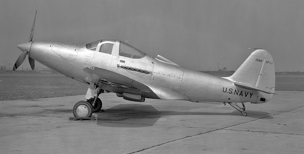
A 4/1/42 USN photo of the sole example of the Bell XFL-1 Aerobonita, 1588, at Mustin Field.
The XFL-1 was a tailwheel Navy carrier-based version of Bell's P-39 Airacobra.
The first PBN-1 Nomad didn't come off the NAF assembly line until February 1943.

A 1943 Naval Aviation Archives photo of a rare Allied Aviation prototype XLRA-1 amphibious glider
approaching Mustin Field's seaplane ramp following a test run on the water.
The Naval Aircraft Factory was redesignated the Naval Air Material Center in 1943.
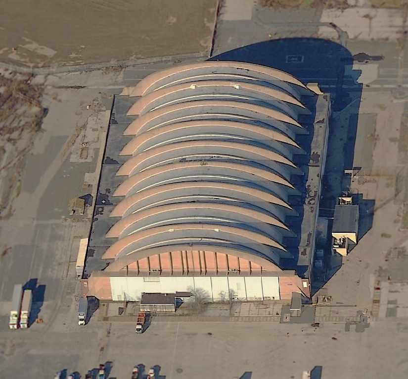
In 1943 the Seaplane Hangar (Building 653) was built on the south side of Mustin Field.
Designed by engineers Roberts & Schaefer,
the large steel-framed concrete-arched hangar measured 302' x 273', and 49' high.

A 1944 photo of PBN-1 Nomad flying boats under construction
inside the Naval Air Material Center at the Philadelphia Naval Shipyard.
Of the 156 PBN-ls produced in Philadelphia, 138 went to the U.S.S.R. under Lend-Lease.
The remaining 18 aircraft were assigned to training units at NAS Whidbey Island & NAF Newport.
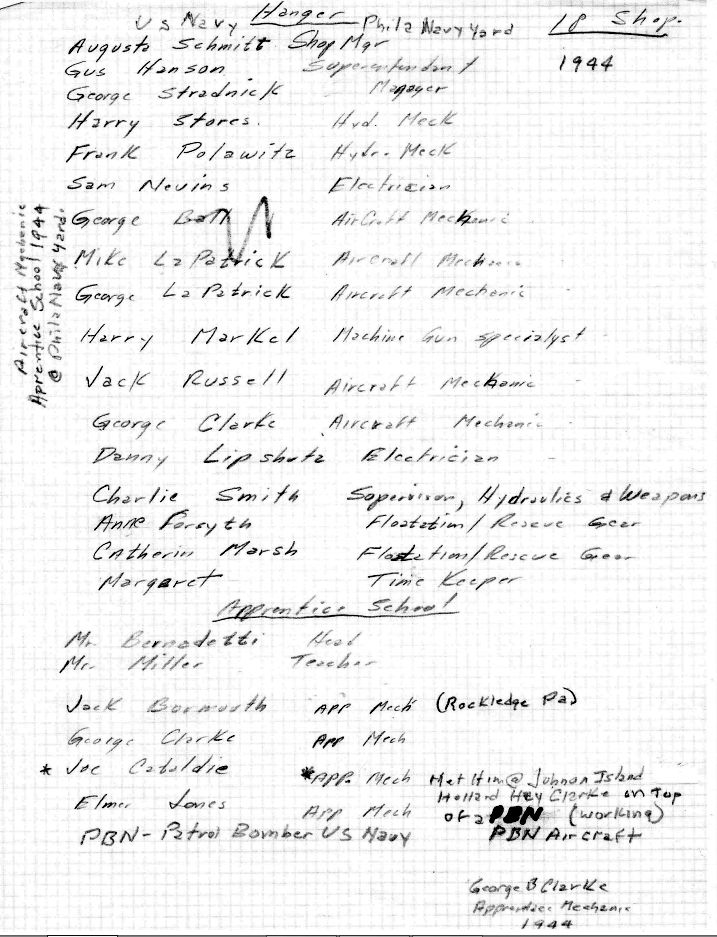
A handwritten list by George Clarke of everyone who worked in the hangar at the Philadelphia Navy Yard in 1944 (courtesy of Nancy Plunkett).
According to George's daughter Nancy Plunkett, George “was just 16 when he began working there as an apprentice airplane mechanic.”
Nancy Plunkett recalled, “My father [Geoge Clarke] worked at the Navy Yard from 1944-49.
He told me about a couple of RAF pilots that had come to take possession of one of a PBY-5 in circa 1945 & fly it back to Britain.
They rolled it down the ramp & into the Delaware & proceeded to begin to accelerate down the river to take off.
Unfortunately, they had not secured the rear cargo door & the plane quickly began to take on water.
My father said the faster they tried to go, the more water poured into the rear of the plane & the lower it got in the water,
ultimately submerging the engines & sinking the plane completely. The pilots were not injured & swam to safety.
One can only imagine what the repercussions may have been!”
In September 1944, Mustin Field played host to trials for a very unusual aircraft:
an Army P-51 Mustang which had been modified to evaluate its use from Navy carriers.
The program was given the name “Project Seahorse”.
An early-series P-51D was selected: P-51D-5-NA serial # 44-14017 which had been retained by North American Aviation
was given the Navy Bureau of Aeronautics (BuNo) 57987.
A tailhook was fitted, which required an extended keel line on which to fix the tailhook attachment point.
A catapult hook was fitted on the fuselage centerline, just forward of the wing.
To cope with hard carrier landings, the tires were replaced with special high-pressure ones.
The main undercarriage shock absorbers received increased air pressure to reduce bouncing upon landing.
The airframe was also reinforced in various points to withstand the extra stress.
Thus modified, 44-14017 was redesignated ETF-51D & sent to Mustin Field for initial testing in September 1944.
The pilot in charge of testing the ETF-51D was Navy Lieutenant Robert Elder,
an experienced naval test pilot who had already conducted carrier-suitability trials with several types of aircraft.
One of the runways at Mustin Field was specially modified in order to test the naval Mustang.
Markings simulating the size of an aircraft carrier's deck were realized
and arrester cables were installed, as well as a launch catapult.
During the months of September & October 1944, Lt. Elder made nearly 150 simulated launches & landings with the ETF-51D.
Sufficient data concerning the Mustang's low speed handling had to be gathered before carrier trials could begin.
The Mustang's laminar-flow wing made for little drag & high speed but was relatively inefficient at low speed, resulting in a high stall speed.
As the arrester cables could not be engaged at more than 90 mph,
Elder reported that “from the start, it was obvious to everyone that the margin between the stall speed of the aircraft (82 mph)
and the speed imposed by the arrester gear (90 mph) was very limited.”
By late October 1944, Elder had amassed enough data
and the ETF-51D entered the next stage: live carrier operations at sea,
thus ending its tenure at Mustin Field.
Mustin Field's Naval Aircraft Factory ended aircraft production in early 1945.
During WW2, it built a total of 31 SBNs (license-built version of the Brewster SBA),
44 SOCs, 331 OS2N (license-built version of the Vought OS2U-3), and 156 PBN-1s.
The existence of the Naval Aircraft Factory was controversial at times
as it put a federally-funded industrial activity in direct competition with civilian industry, and this was one of the reasons it was disestablished.
Upon disestablishment, most aircraft test functions were passed to the newly formed Naval Air Test Center at Patuxent River, MD.
A WW2-era Navy photo looking east at Mustin Field.
The 1945 AAF Airfield Directory (courtesy of Scott Murdock) described Mustin Field
as a 328 acre irregularly-shaped property within which were 3 macadam runways, with the longest being the 4,280' northwest/southeast strip.
The field was said to have a single 150' x 100' metal hangar.
It appeared as if the Naval Aircraft Factory (along the river) had been removed at some point between 1944-45.

A 1940s USN aerial view looking northwest showed Mustin Field to have 3 paved runways.

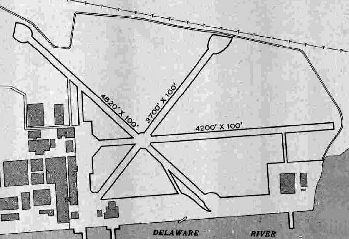
The 1947 Washington Sectional Chart depicted NAAS Mustin as having a 4,500' hard-surface runway.
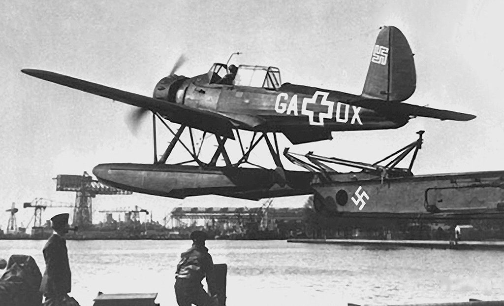
A 1947 photo of captured German Arado Ar-196A05 GA-DX, C/n 62317, being launched from a catapult at Mustin Field.
The captured German cruiser Prinz Eugen had sailed to the US in 1946 with 2 Ar-196s on board.
The ship's catapult was installed at Mustin Field & test launches were carried out, with spurious markings painted on this aircraft.
This particular Ar 196A-5 had been built by Fokker in Amsterdam.
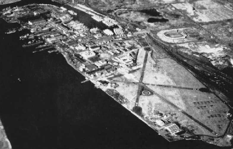
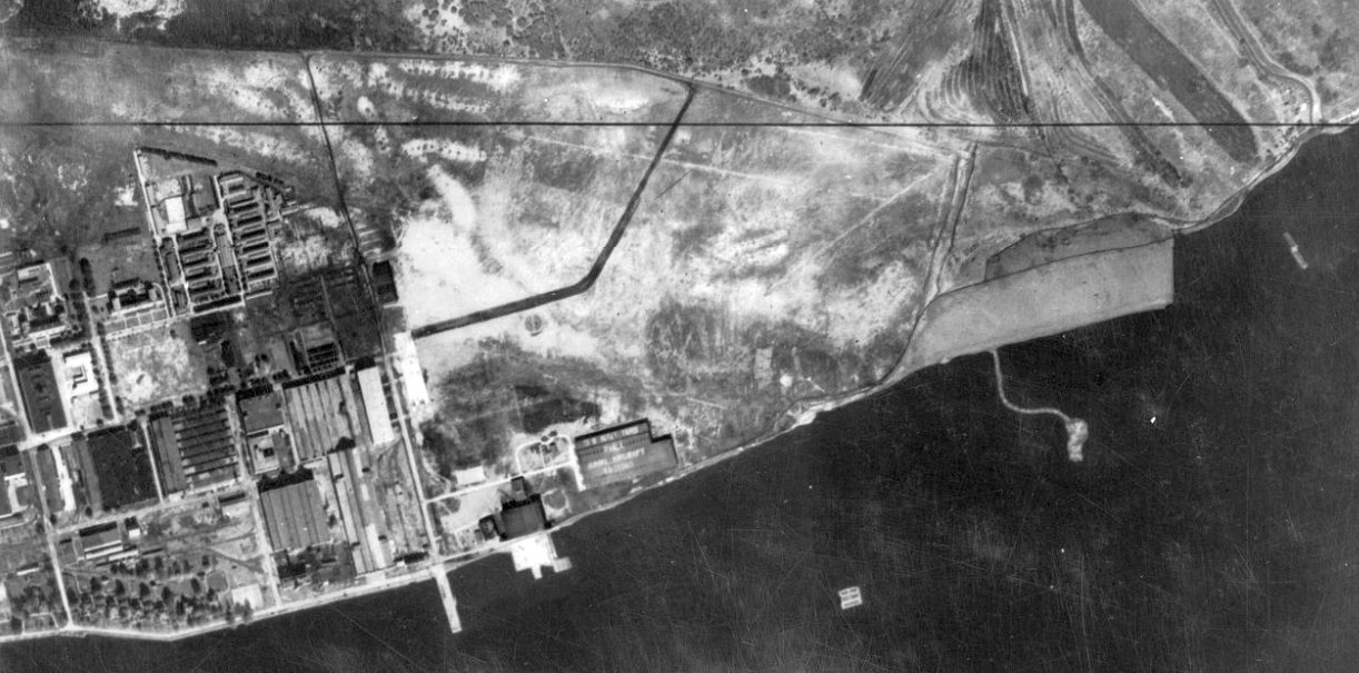
A circa 1947 aerial view looking northwest at Mustin Field from the Naval Aviation News.
The airfield area had been expanded considerably (evidently with filled-in land) to the east, compared to an earlier photo.
The airfield consisted of 3 paved runways, with the primary runway having been significantly lengthened toward the east,
and the large arch-roof hangar had been added on the southeast side of the field.

A 1949 aerial view looking west at Mustin Field showed several dozen aircraft stored on the northeast portion of the field.
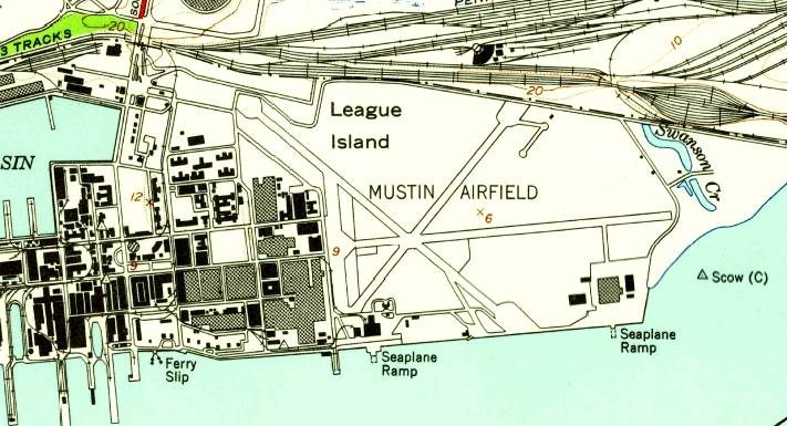
The 1949 USGS topo map depicted Mustin Airfield as having 3 paved runways, with hangars & seaplane ramps along the south side.
In 1950, Mustin Field was designated the Naval Air Experimental Station, which included numerous research laboratories.
A 1953 aerial photo showed a total of 17 aircraft parked on Mustin's ramp.
The primary runway at Mustin was apparently lengthened by 1955,
as the 1955 Washington Sectional Chart (courtesy of Mike Keefe)
described "NAAS Mustin" as having 3 paved runways, with the longest being 5,200'.
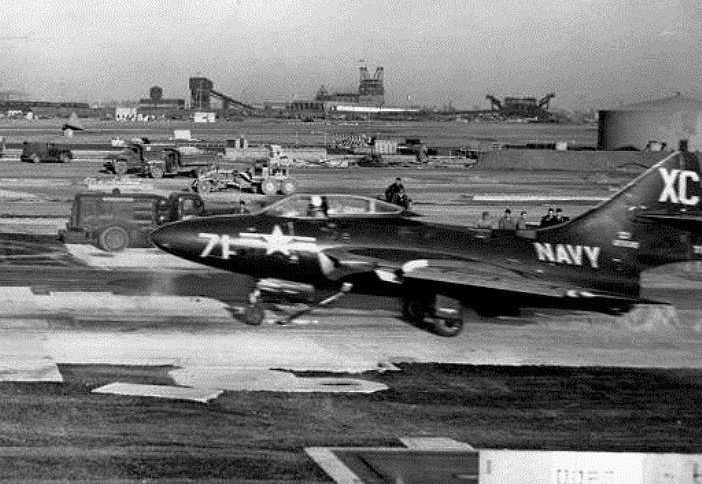
A 1950s photo of catapult testing at Mustin Field using a Grumman F9F-6 Cougar.
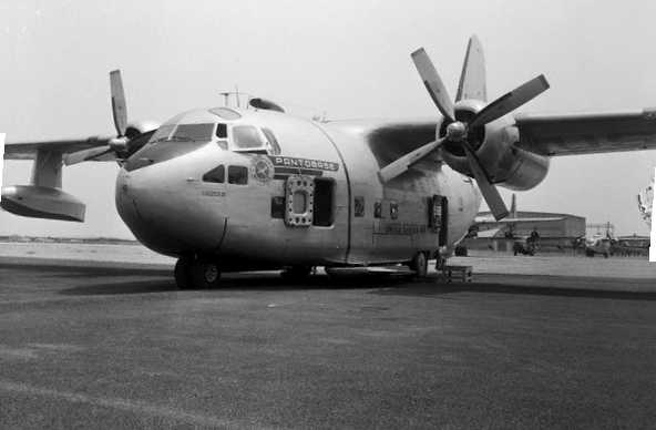
A 7/28/55 photo of the YC-123E Pantobase prototype at Mustin Field,
prior to its water takeoff trials.
The YC-123E was a Fairchild C-123 Provider which had been modified by the Stroukoff Aircraft Corporation with a Boundary Layer Control system,
4-blade propellers, 2 high-stress skis fitted to the lower fuselage, wing-mounted floats, and a sealed fuselage.
This gave the YC-123E the ability to operate on water, ice, and snow, along with airstrips of shorter length.
Mustin's primary runway was extended again within the next 2 years,
as the 1957 Philadelphia Local Aeronautical Chart (courtesy of Chris Kennedy)
described "Mustin ALF (Navy)" as having 3 paved runways, with the longest being 6,100'.
A 1957 aerial view depicted Mustin Field as having 3 paved runways.
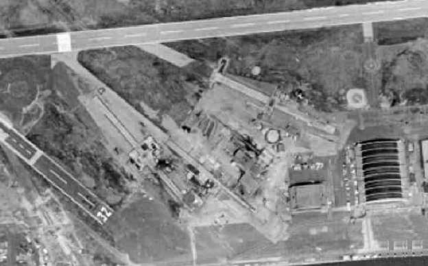
A closeup from the 1957 aerial view, showing what appear to be 2 sets of aircraft carrier catapults &/or arresting gear, installed on the south side of Mustin Field.

A closeup from the 1957 aerial view, showing amazing variety of aircraft parked on the ramp on the southwest side of Mustin Field.
Robert Johnston shed some light on the variety of aircraft in the preceding photo:
“In the 1950s one of my greatest thrills was to ride around the base sightseeing with my dad, who was a LCDR in the Naval Reserve.
Part of the fun was exploring every nook & cranny that was not off limits,
including the Naval Air Engineering Center which was served by Mustin Field.
Quite a few years later, as a Lt. USNR myself,
I was stationed at Naval Air Development Center & I made many trips down to NAEC to work with the staff there.
The aircraft in the aerial view were mostly if not all stripped hulks used for catapult testing.
NAEC had the responsibility for all catapult research & development and troubleshooting.
Typically, the aircraft used for catapult testing had their engines removed
and replaced with cast iron or lead weights bolted into the fuselage.
They presented a pretty sorry spectacle to the casual observer.
In the mid- to late-1950s the only aircraft stationed at Mustin Field as far as I know
were Beech SNBs used for liaison work & VIP transport.
My dad knew one of the pilots quite well & I recall him giving us the inside tour of Mustin Field.
Of course, just like NADC when I was stationed there from 1970-1972,
I am sure that aircraft of various types were modified at NAEC for R&D purposes & sent back out to the fleet for evaluation.”
The 1960 Jeppesen Airway Manual (courtesy of Chris Kennedy)
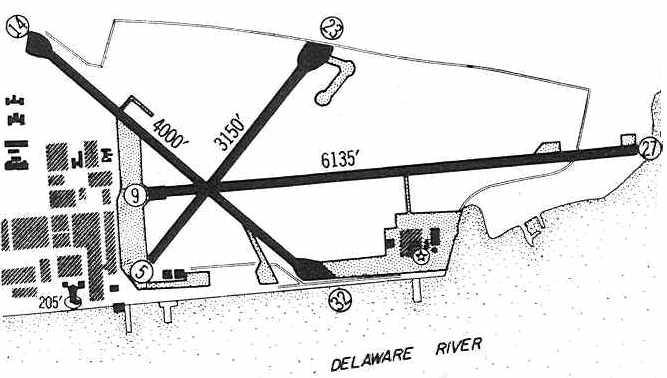
depicted "Mustin ALF" as having 3 paved runways, with the longest being the 6,135' Runway 9/27.
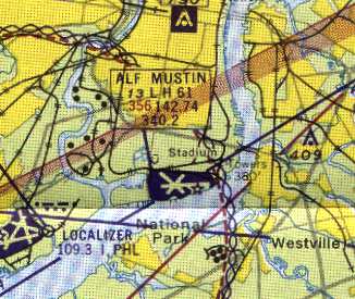
"ALF Mustin" was still depicted as an active Navy airfield
on the 1961 Philadelphia Local Aeronautical Chart (courtesy of Mike Keefe),
with 3 runways, the longest of which was a 6,135' bituminous strip.
The Naval Air Material Center was redesignated the Naval Air Engineering Center in 1963.
Mustin Field was closed in 1963, in part due to its location immediately underneath
airline traffic on final approach to nearby Philadelphia International Airport.
It was labeled "Abandoned airport" on the January 1963 Philadelphia Local Aeronautical Chart (courtesy of Mike Keefe).
A 1963 aerial photo did not show a single aircraft on the field, a dramatic change from the 1957 photo.
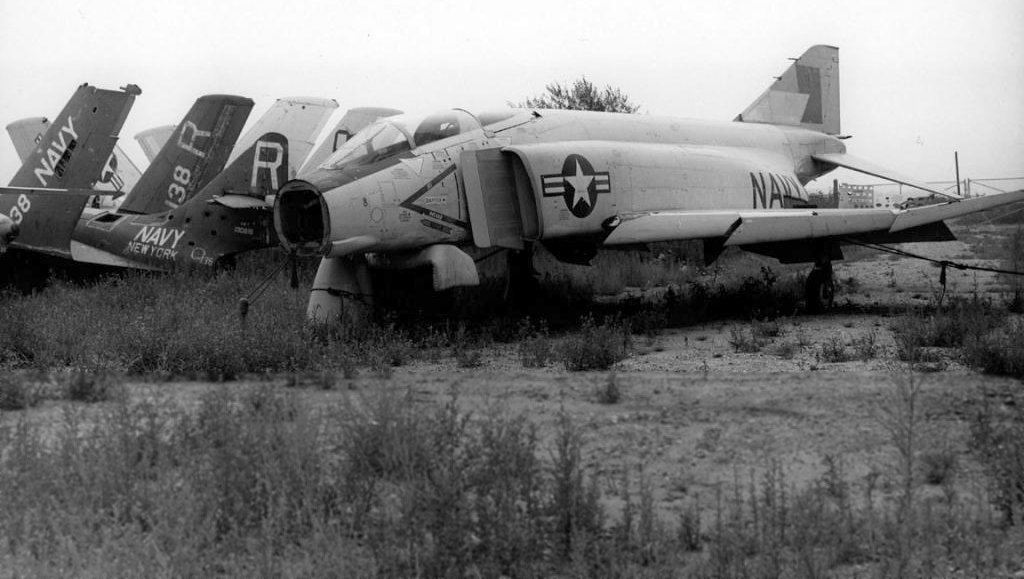
An undated (circa 1960s?) photo of a forlorn McDonnell F4H-1 (the rare very first model of the famous Phantom II) reportedly at Mustin Field,
along with several other Navy jet fighters.
What was their purpose at Mustin?
A May 1967 photo at Mustin Field of BuNo 121460, a 1948 North American XAJ-1 Savage, serial #146-38429,
used as a Naval Air Engineering Lab / Grumman dead-load test airframe for development of E-2 & A-6 nose-tow gear.
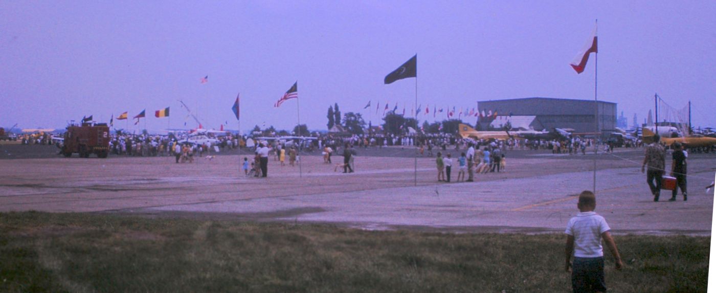
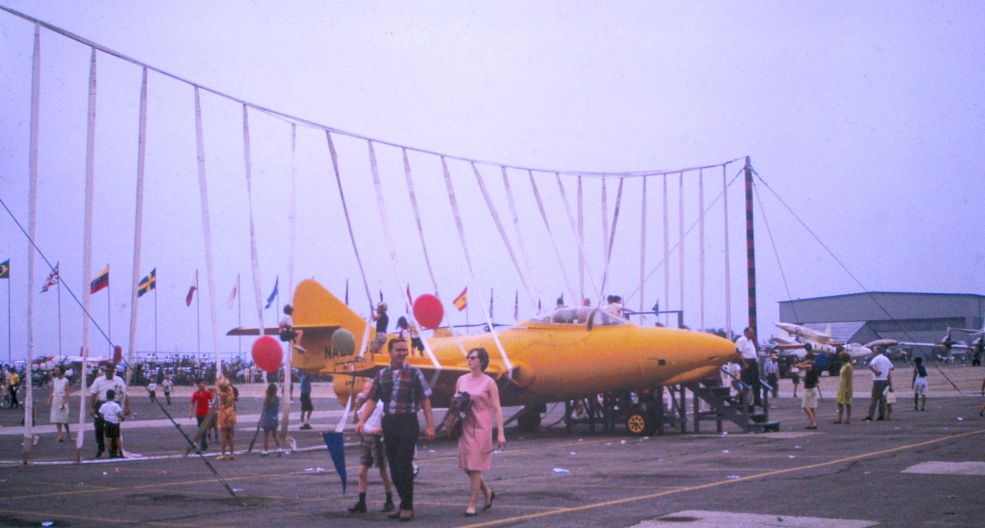
An October 1967 photo by Jack Kenton of an airshow at Mustin Field.
Jack recalled, “Special permission from the FAA was gotten so as to have this event. The field is right under the approach to Philadelphia International Airport's main runway.”
An October 1967 photo by Jack Kenton of a Grumman F9F Panther displayed within a aircraft carrier landing barrier at an airshow at Mustin Field.
Note that the Panther, apparently not airworthy, was missing its normal wingtip fuel tanks.
Also note the Air Force North American AGM-28 Hound Dog nuclear supersonic cruise missile in the background at right.
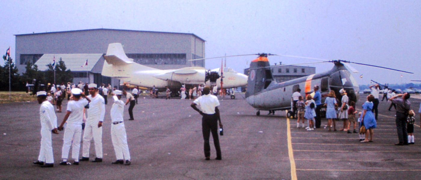
An October 1967 photo by Jack Kenton of a all-white Navy North American AJ Savage bomber (minus outer wings) & a Piasecki HUP Retriever helicopter (in foreign markings?) on display at a Mustin airshow.
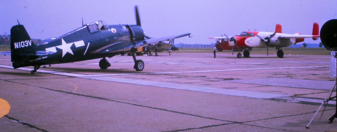
An October 1967 photo by Jack Kenton of a Grumman F6F Hellcat & a civilian B-25 Mitchell bomber (with a glass nose presumably for aerial photography) participating in a Mustin airshow.
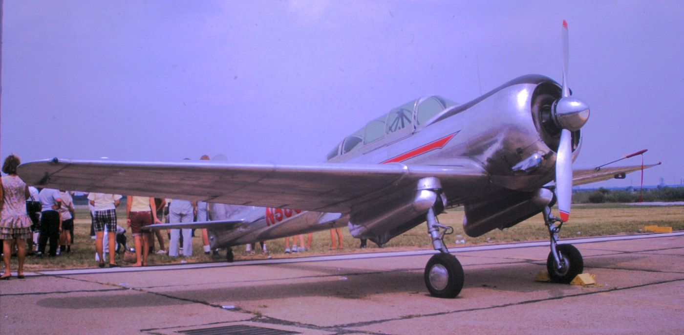
An October 1967 photo by Jack Kenton of a beautiful polished metal Curtiss CW-22 on display at a Mustin airshow.
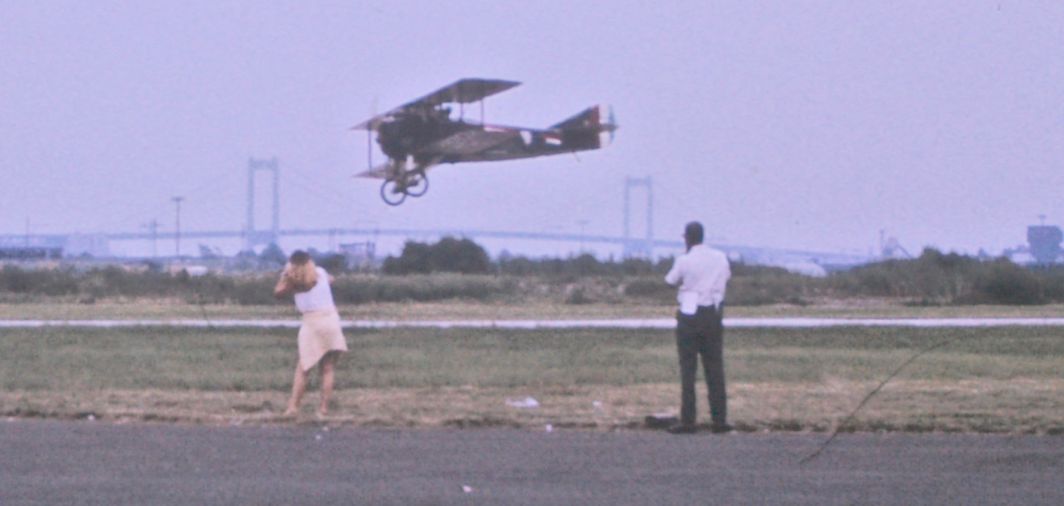
An October 1967 photo by Jack Kenton of a WW1 SPAD replica flying as part of an airshow at Mustin Field.
It had departed from the grass adjacent from Mustin's paved runway.
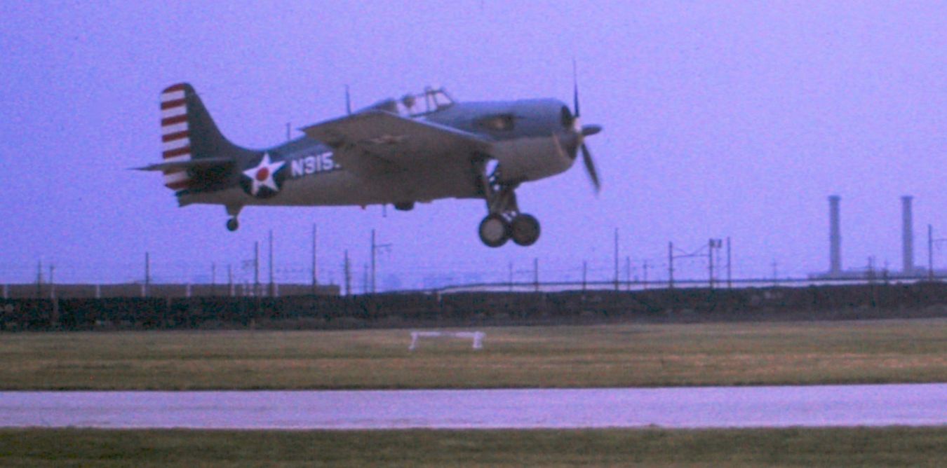
The last photo which has been located of an aircraft flying from Mustin's runway was an October 1967 photo by Jack Kenton of a Grumman (General Motors) FM-2 Wildcat landing as part of an airshow at Mustin Field.

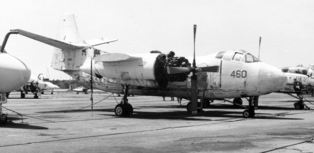
An October 1967 photo of BuNo 151941, a Boeing Vertol NCH-46A Sea Knight, serial #2091, an NATC service test aircraft at Mustin Field.
The last aviation use of the Mustin facilities came after the airfield was actually closed.
In 1971, the seaplane ramp at Mustin was briefly used for testing of the X-28 Osprey, a small, single-place seaplane.
These tests were intended to explore the usefulness of the Osprey for civil police patrol in Southeast Asia,
and it made a unique contribution as a home-built aircraft in the X-Plane program.
The Osprey also was very unusual for a modern American fixed-wing military aircraft, was actually an open-cockpit aircraft.
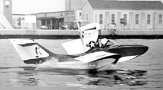
An undated photo of the sole X-28 Osprey in tests from the Delaware River at Mustin.
The X-28 testing at Mustin was complicated by the FAA mandate that all flying be restricted to no higher than 300' altitude,
given the conflict with air traffic from Philadelphia International Airport.

The last photo which has been located of an aircraft at Mustin Field was a May 1973 photo of BuNo125413,
the 2nd prototype Douglas XA3D-1 Skywarrior, serial #7589, on static display.
Dave Lewis recalled, "I was stationed at Philadelphia Navy Yard in 1973-74.
I worked for special services & I recall that in the spring of 1974
we were involved in a project to convert the big blimp hangar at the field into a recreational facility.
We built 3 or 4 indoor tennis courts inside the hangar
and set up a weight room in one of the machine shops that was located next to the big hangar work floor.
I also remember seeing store rooms in the hangar that were full of all sorts of parts including dummy Sparrow missiles."
Diana Cannon recalled, “I'm a former Navy brat and lived in that brick 'residential complex' next to that big hangar in 1980-83.
I have fond memories of that place. Wow... I never realized I was riding my bike down a landing strip!
When I lived there, that big hangar was the commissary.”
In 1974, the Naval Air Engineering Center was relocated to Lakehurst, NJ.
The Naval Aircraft Factory's main construction building was converted for use by the Naval Surface Warfare Center, Carderock Division,
as a facility for research & development.
The closure of the Philadelphia Navy Yard was recommended in 1991 by the Base Realignment & Closure Commission.
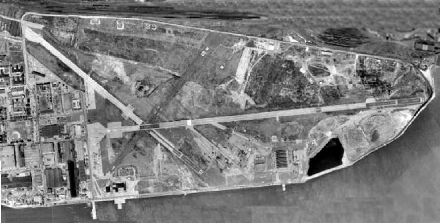
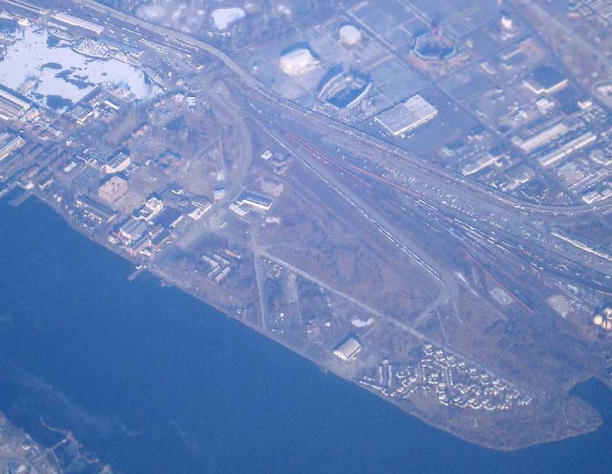
A 1992 USGS aerial view looking northeast at Mustin Field showed the remains of the 3 paved runways, ramps, taxiways, and hangars.
Although local politicians tried to keep the Philadelphia Navy Yard open, it finally closed in 1995 with a loss of 7,000 jobs.
Senator Arlen Specter charged that the Department of Defense did not disclose the official report on the closing.
This resulted in a controversy that led to further legal disputes to no avail.
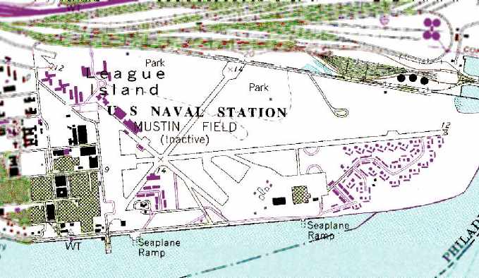
The 1998 USGS topo map depicted the “U.S. Naval Station Mustin Field (Inactive)”
as having 3 paved runways, ramps, taxiways, and hangars.
In the 1990s, the adjacent shipyard property was being redeveloped as a civil shipyard by the Kvaerner Corporation.
Plans for the airfield property are unknown.

As seen in a 2002 USGS aerial photo,
the hangar along the south side of Mustin Field remained intact.
Note the seaplane ramp leading down into the Delaware River, just below the hangar.
Diana Cannon reported in 2005 of the hangar area, “I heard future plans could be condos & a marina in that area.”
A circa 2005 aerial photo looking north at Mustin's hangar on the south side of the runway.

A circa 2006 aerial photo looking west at what may have been the Mustin airfield operations building (located northwest of the runways),
which appears to have what may have been a control tower atop the right side of the building.
A circa 2006 aerial photo looking south at what appears to be another former hangar at Mustin (located northwest of the runways),
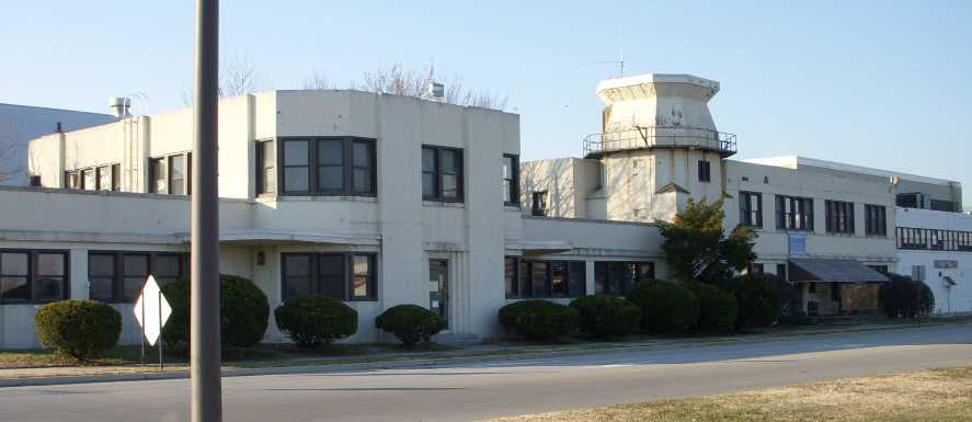
A 2008 photo by Everett Priestley looking northwest at “what was obviously the control tower & operations center at the end of [Runway] 27.”
Everett Priestley visited the site of Mustin Field in 2008.
He reported that the Navy installation is now known as the Philadelphia Naval Business Center,
with a sign for “Mustin Intermodal” at the former airfield.
Everett reported, “Kaeverner Shipyard is now known as Aker Philadelphia Shipyard.
The Navy still has a small presence in the old yard with their with alternative fuels research, inactive ships fleet, and other engineering detachments.
A 2008 photo by Everett Priestley looking south at Mustin's former hangar.
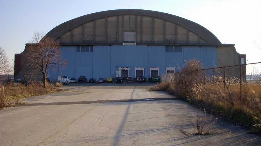
Everett reported, “The main hangar is still standing & is reasonably good shape.
On the South side of the hangar outside wall are the words 'Base Commissary'.
There was a man-lift & crews doing some welding & brush clearing.
I asked one of the construction workers concerning what their were working on,
and he said that the hangar was being converted into a indoor movie studio.
He also claimed that it was the largest standing concrete structure in the world.”

A 2008 photo by Everett Priestley looking east along Mustin's former Runway 9.
Everett reported, “Runway 9/27 is still there, the yellow X's barely visible.”
A January 2009 aerial view by Paul Freeman looking northwest at Mustin's former runways.
Nathan Hauser reported in 2011, “I manage a tugboat company located at the Navy Yard, adjacent to what used to be Mustin NAF.
I have spent quite a bit of time getting exercise in the area & fully appreciate all the aviation experimentation that occurred here.
There are still remnants of runways, markings and several hangars.
The old catapults & arresting gear can still be located in the weeds if you know where to look.
Unfortunately, with no regard to local history, new development is taking its toll.
About a year ago I took a friend to see the old “factory hangar”,
of which you could still see the painted sign 'BEWARE OF JET AND PROP BLAST' above the copper-trimmed brick building.
I believe this is the same building that [in which there is] a picture of PBYs being built in.
Well, that hangar & factory, even with it’s beautiful architecture, had been unceremoniously torn down & cleared.
The old seaplane hangar is currently being used by Paramount Pictures as a sound stage for making movies.
I recently read that much of the movie 'Avatar' was shot in that building.
There are plans to develop the immediate area into another container ship terminal called Southport.
Doubtful, however, if this will occur as significant funds need to be raised & current terminals are underutilized.”
Kevin Rampton reported in 2011 that the Mustin hangar is “now used as a sound stage, most recently for 'The Last Airbender' [2010].”
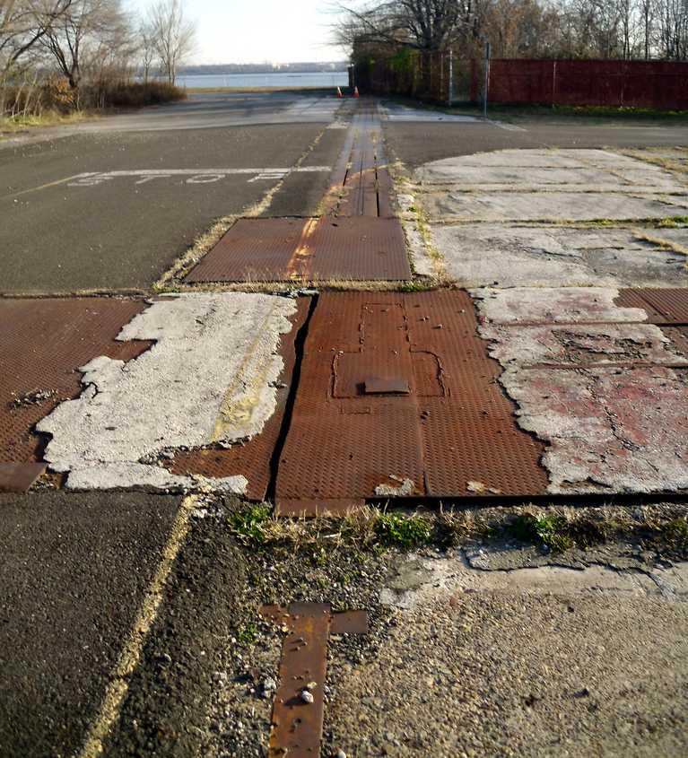
A December 2011 photo by Kevin Rampton looking south at what appears to be the remains of a Mustin catapult.
Kevin Rampton reported in 2011, “The Navy Yard, now officially a business park, has unrestricted access until about 6pm so up until then, one can just drive/ride/ walk right in.
There is major construction going on along Kitty Hawk Avenue, which, I am pretty sure, is made up of Mustin's longest east/west runway.
Pretty much everything south & east of that just seems to be considered 'general use' land, and it's just like riding on any other city street -
which, quote honestly, I didn't expect; I EXPECTED to be told off by security people every 10 feet, but it just didn't happen.
The only part of the site that even hints at being Restricted space, and even then, through signage only,
is the abandoned base housing section east of the hangar.
[I noted] the surreal suburban decay of this section of the yard. Wildlife abounds there, too, which makes it even stranger.
Opossum, turkey vultures, and even an at-least 10-point buck were observed yesterday, but were too fast for the camera.
All in all, one of my favorite urban adventures ever.”
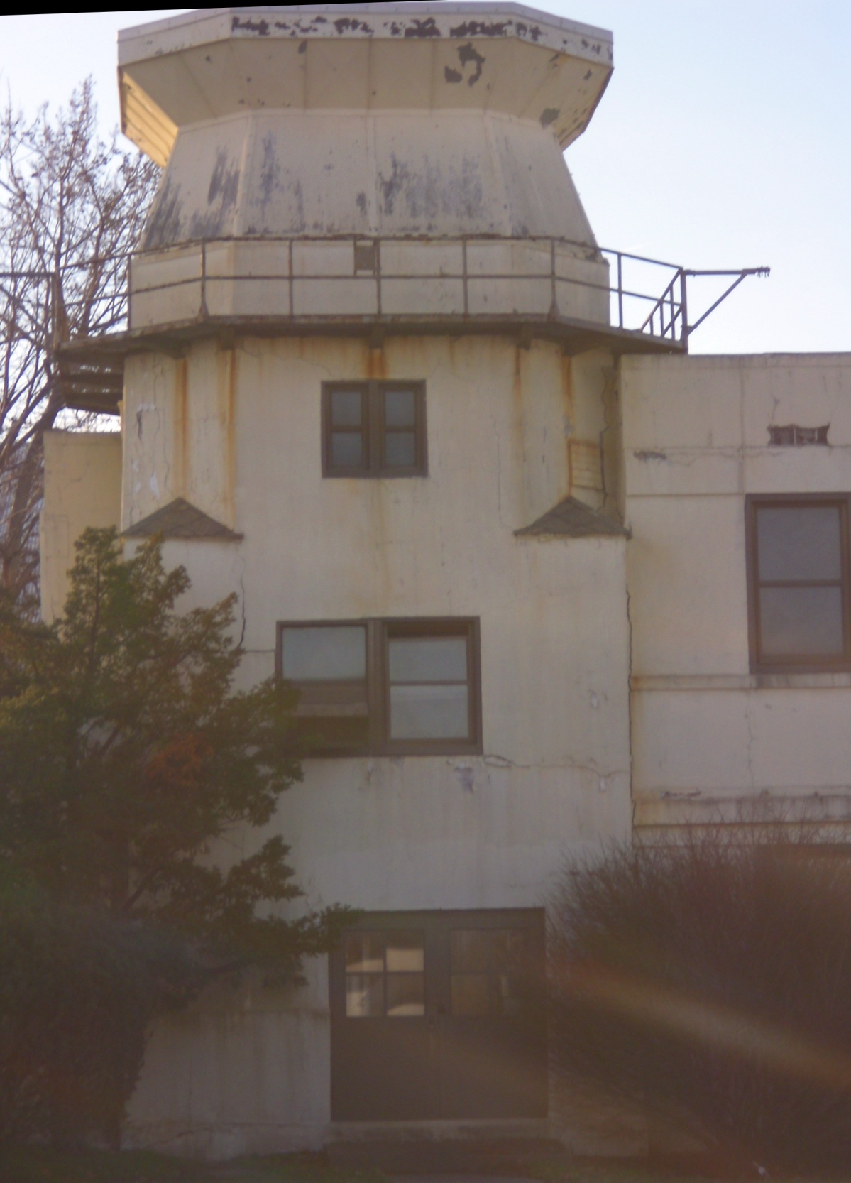
A 1/11/12 photo of the former Mustin Field control tower, with the cab windows boarded up or painted over.

A 2013 photo looking southwest at the Mustin Field Operations Buildings & control tower, shortly before they were demolished.
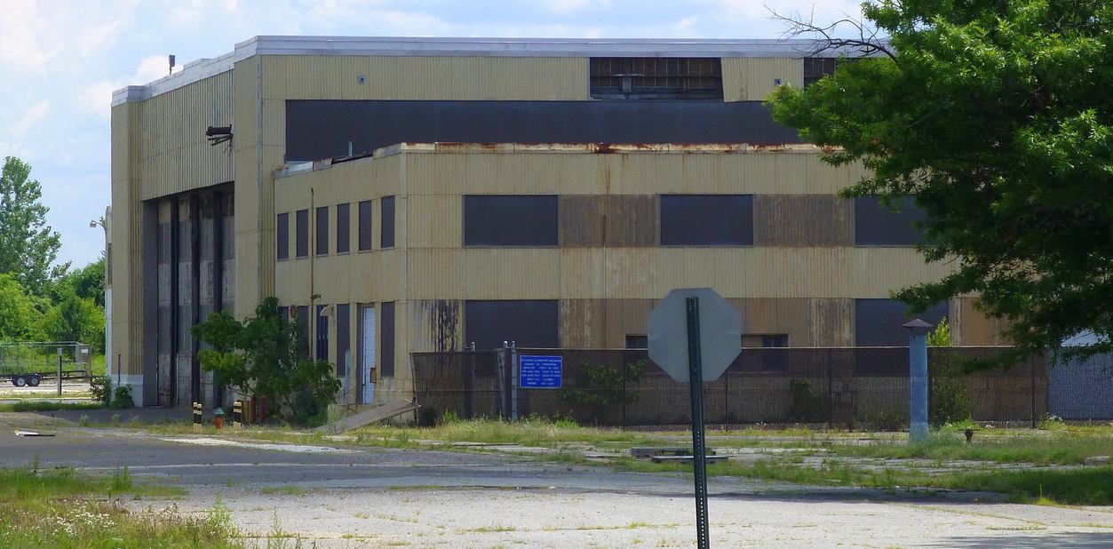
A 7/17/14 photo of a former Mustin Field hangar.
A 2016 aerial view showed that Mustin Field's control tower was completely razed at some point between 2012-2016,
and the adjacent hangar to the north was razed at some point between 2014-2016.
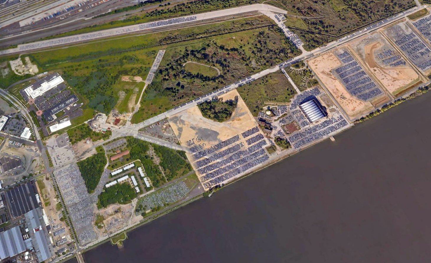
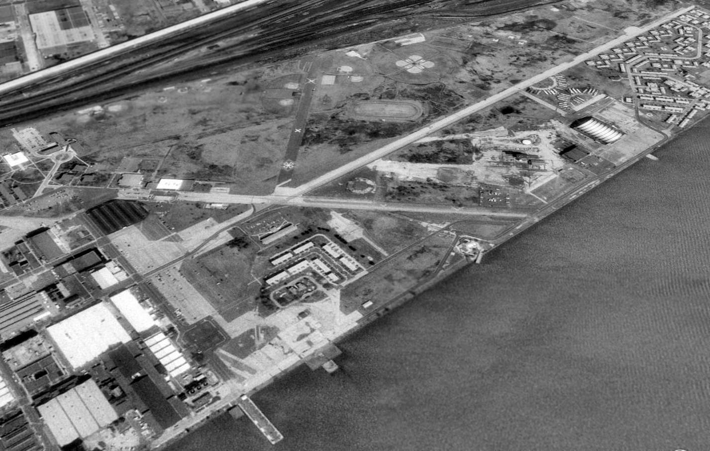
A 2017 aerial view looking northeast at Mustin Field showed the remains of the 3 paved runways, ramps, taxiways, and hangars.
The site of the control tower on the west side of the field had been scraped clean.
Thousands of cars were being stored all over the southern portion of the airfield.

A 2017 3-D depiction of Mustin's hangar on the south side of the runway.
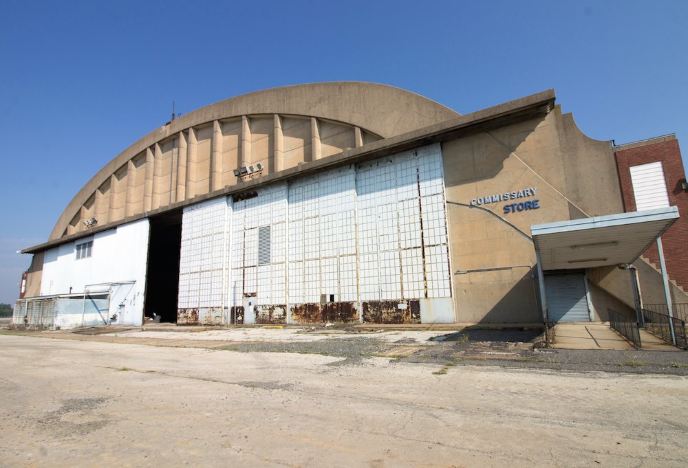
A 2018 photo of the exterior of Mustin's hangar.
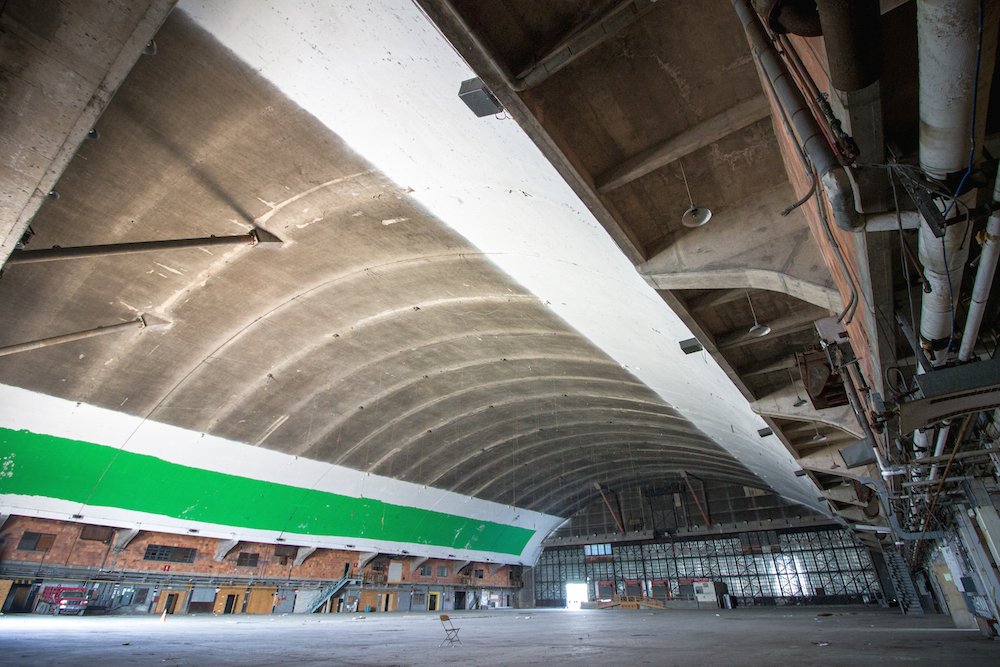
A 2018 photo of the interior of Mustin's hangar.
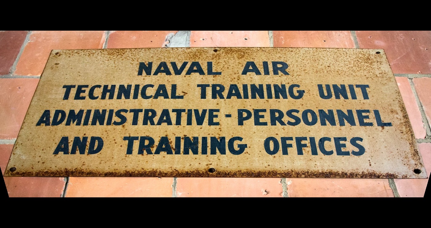
A 2018 photo of a sign for the Naval Air Technical Training Unit inside Mustin's hangar.
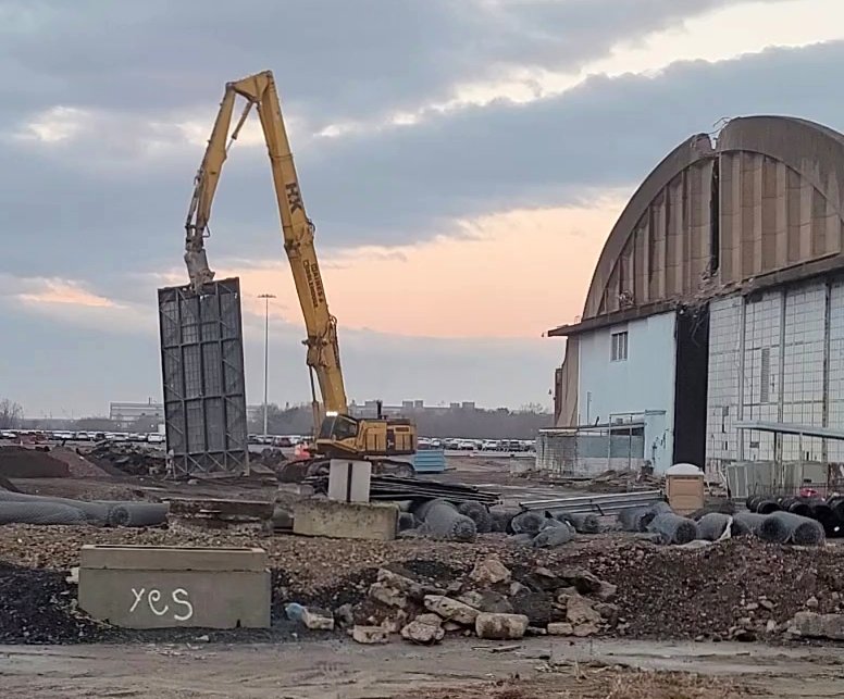
A still from a 2021 video by Russell Schafer looking southeast at the demolition of the first Mustin Field hangar door.
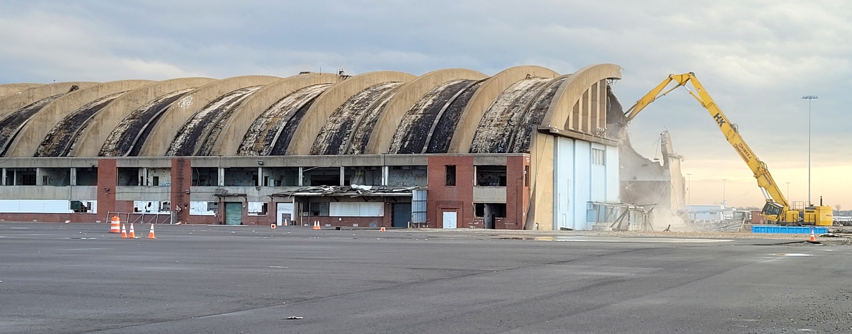
A still from a 2021 video by Russell Schafer looking southwest at the demolition of the Mustin Field hangar.

A still from a 2021 video by Russell Schafer of the site of Mustin Field.
Russell reported, “The whole area is now a giant parking lot for new vehicles imported from Korea; Hyundai & Kia. The old seaplane ramp leading from the hangar into the Delaware still exists.”
____________________________________________________
Or if you prefer to contact me directly concerning a contribution (for a mailing address to send a check),
please contact me at: paulandterryfreeman@gmail.com
If you enjoy this web site, please support it with a financial contribution.
____________________________________________________
This site covers airfields in all 50 states.