
Abandoned & Little-Known Airfields:
Southeastern South Carolina
© 2002, © 2026 by Paul Freeman. Revised 2/15/26.
This site covers airfields in all 50 states: Click here for the site's main menu.
____________________________________________________
Please consider a financial contribution to support the continued growth & operation of this site.
Carlisle Field / (Original) Bamberg County Airport (revised 8/4/19) - Charleston Navy Yard Field (1st location) (revised 6/11/20)
Charleston NAS (2nd location) (revised 7/14/22) - Isle of Palms Airport / Harold F. Wilson Memorial Airport (revised 8/4/19)
Parris Island Landing Field / Page Field MCOLF (revised 2/15/26) - Pinckney Airport / Remleys Point Airport (revised 11/3/24)
____________________________________________________
Carlisle Field / (Original) Bamberg County Airport, Midway, SC
33.277, -80.972 (East of Charleston, SC)
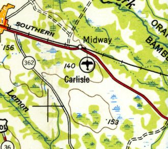
Carlisle Field, as depicted on the October 1945 Savannah Sectional Chart.
This small general aviation airport was evidently established at some point between in 1945,
as it was not yet depicted on the 1943 USGS topo map or the March 1945 Savannah Sectional Chart,
nor listed in the 1945 AAF Airfield Directory (courtesy of Scott Murdock).
The earliest depiction which has been located of Carlisle Field was on the October 1945 Savannah Sectional Chart.
Carlisle Field, as depicted on the 1954 USGS topo map.
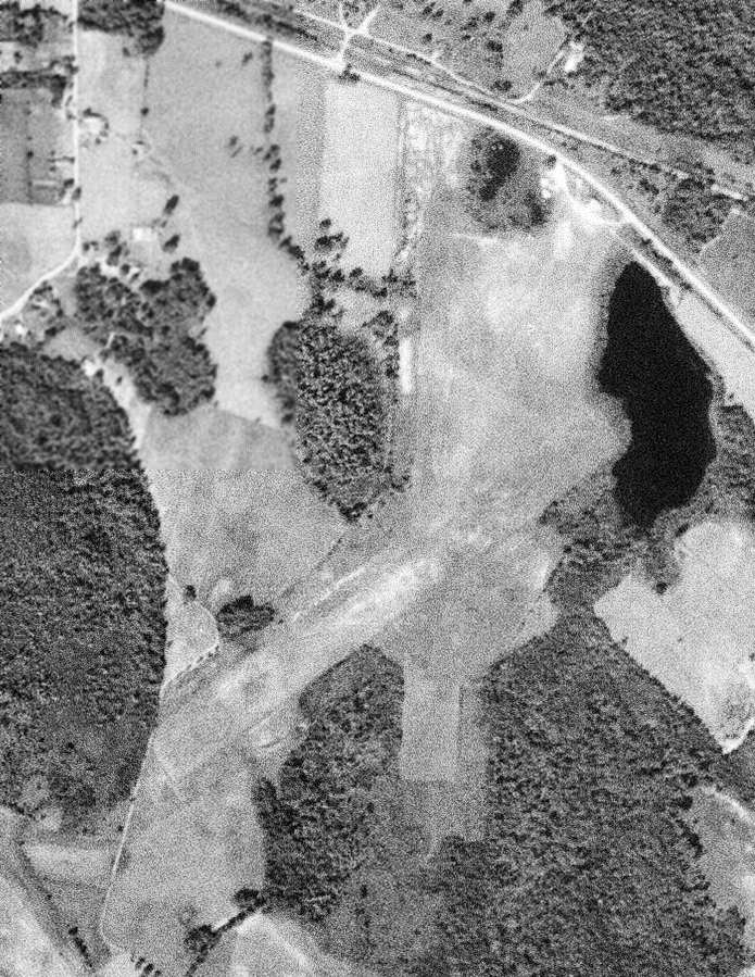
The earliest photo which has been located of Carlisle Field was a 1961 USGS aerial view.
It depicted Carlisle as having 2 unpaved runways.
The last aeronautical chart depiction which has been located of Carlisle Field was on the 1964 Savannah Sectional Chart.
It depicted Carlisle as having a 2,600' unpaved runway.
A 1964 USGS aerial photo depicted 3 T-hangars (& possibly a somewhat larger 4th hangar) on the north side of Carlisle Field,
but no aircraft were visible on the field.
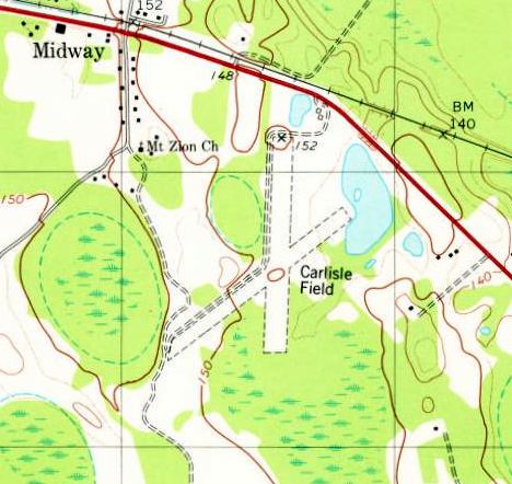
The 1979 USGS topo map depicted Carlisle Field as having 2 unpaved runways.
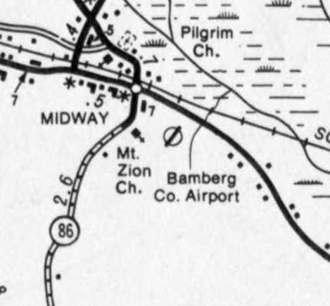
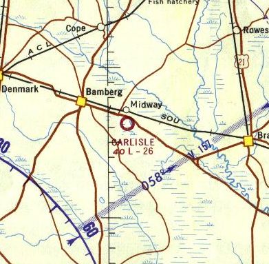
The airport was evidently renamed Bamberg County Airport at some point between 1979-84,
as that is how it was labeled on a 1984 SC DOT map (courtesy of Craig Williams).
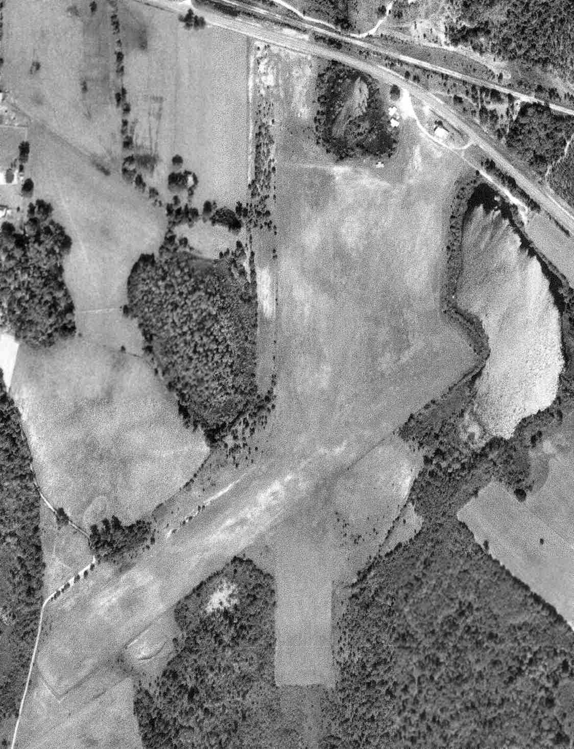
A 1989 aerial photo showed Carlise Field's 2 runways were still clear.
A 2005 aerial photo showed Carlisle Field's runways were overgrown.
It had evidently been replaced by a larger Bamberg County Airport several miles to the west.
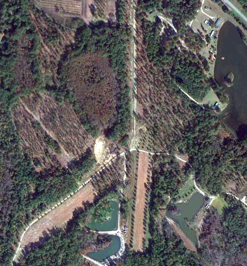
A 2014 aerial view showed the outlines of Carlisle Field's 2 runways were still recognizable.
The site of Carlisle Field is located south of the intersection of Route 78 & Dot's Court.
Thanks to Craig Williams for pointing out this airfield.
____________________________________________________
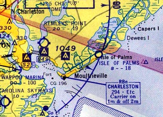
Isle of Palms Airport / Harold F. Wilson Memorial Airport, Isle of Palms, SC
32.802, -79.772 (East of Charleston, SC)
Isle of Palms Airport, as depicted on the January 1953 Savannah Sectional Chart.
No airport was yet depicted at this location on the 1943 USGS topo map or the January 1950 Savannah Sectional Chart.
According to Lester Hollans, “Harold F. Wilson Memorial Airfield at Isle of Palms had opened in 1951 with an 1,800' oyster-shell-covered runway.”
According to the Charleston International Airport website (courtesy of Thomas Page),
“The Isle of Palms Airport was built in the early-1950s to provide a recreational airport adjacent to the island’s beaches.
It provided a 2,900’ turf airstrip situated along the Intracoastal Waterway.
[It was] originally constructed & operated by the South Carolina Aeronautics Commission.”
The earliest depiction which has been located of Isle of Palms Airport was on the January 1953 Savannah Sectional Chart.
It depicted Isle of Palms Airport as having a 2,100' unpaved runway.
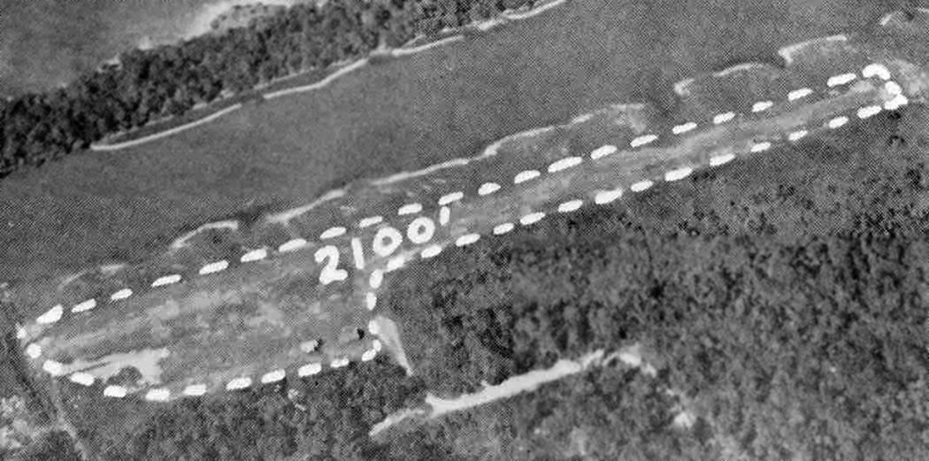
The earliest photo which has been located of Isle of Palms Airport was an undated aerial view from a circa 1957 SC Airport Directory (courtesy of Don Fraser).
It depicted Isle of Palms Airport as having a single unpaved 2,100' northeast/southwest runway, with 2 T-hangars on the southwest side.
The directory said that the manager was the SC Aeronautics Commission,
and said that there was a proposed runway extension to 3,000'.
A 3/30/57 USGS aerial photo depicted 1 single-engine aircraft parked between 2 T-hangars on the southwest side of Isle of Palms Airport.
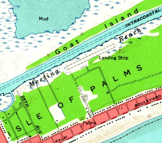
The earliest topo map depiction which has been located of Isle of Palms Airport was on the 1959 USGS topo map.
It depicted a single unpaved northeast/southwest runways, labeled simply as “Landing Strip”, with 2 small buildings on the southwest side.
The airport was evidently renamed Wilson Memorial Airport at some point between 1959-61,
as that is how it was labeled on the 1961 Savannah Sectional Chart (courtesy of Lester Hollans).
Wilson was depicted as having a 2,100' unpaved runway.
Lester Hollans recalled, “In 1962 I was flying an Army L-19 Bird Dog from Fort Rucker, AL, to Charleston AFB.
When I arrived the 65 mph tailwind I had enjoyed was going to prevent me or anyone else from landing at Charleston because it was a direct crosswind there.
I knew I'd crash & roll into a ball, so I asked for permission to land my little plane straight across the runway, into that 65-mph wind.
I would only need about 300' to land under the circumstances.
The control refused me permission, citing Air Force regulations that said anyone landing at the field had to use the active runway - even if it meant death - and told me to get lost.”
Hollans continued, “I was nearly out of fuel & had to find somewhere to land. It was near sunset by now.
I remembered from my weather classes that the winds shift in the evening & come in from the ocean as the ocean surface cools.
I correctly assumed that would cancel the high winds coming from the West.
I found a little field on the beach to land on & slept on the beach.
That field was the (Harold F.) Wilson Memorial Airfield at Isle of Palms.
It had an 1,800' oyster-shell-covered runway & was parallel to the Intercoastal Waterway.
The last aeronautical chart depiction which has been located of Wilson Memorial Airport was on the September 1970 Charlotte Sectional Chart (courtesy of Ron Plante).
Wilson was depicted as having a 2,900' unpaved runway.
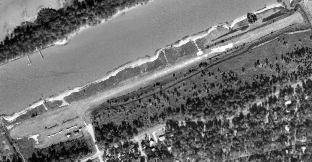
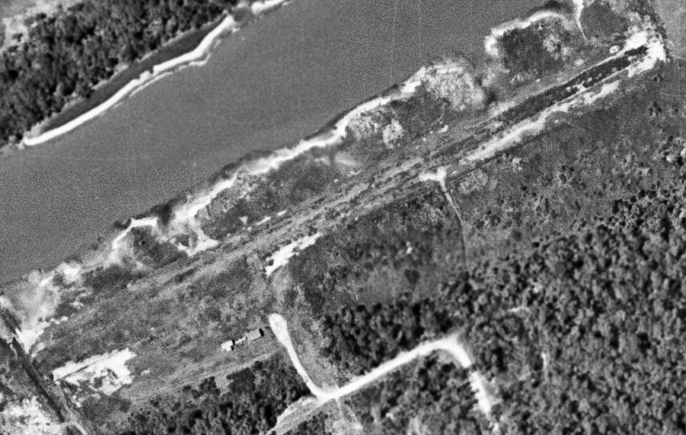
The last photo which has been located showing Isle of Palms Airport in operation was on a 12/26/71 USGS aerial view.
It showed Isle of Palms Airport at perhaps the zenith of its popularity, with 8 single-engine aircraft parked next to the 2 T-hangars on the southwest side of the field.
The 1973 USGS topo map still labeled it as “Landing Strip”.
According to Lester Hollans, “That little strip [Wilson Memorial] apparently was closed in 1975.”
The airport was labeled “Harold F. Wilson Memorial Airport” on the 1980 USGS topo map.
According to the Charleston International Airport website (courtesy of Thomas Page),
“Ownership was later transferred to the Charleston County Aviation Authority;
however, the airport was located on privately-owned leased land which was recovered in 1983 by the owners for development of the Wild Dunes complex.”
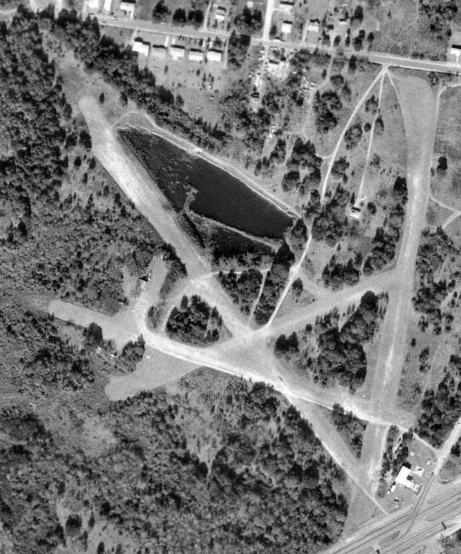
A 2/9/89 USGS aerial photo showed the 2 hangars had been removed, and a golf course was being constructed on the runway.
The 1990 USGS topo map still depicted a single runway, but without any label.
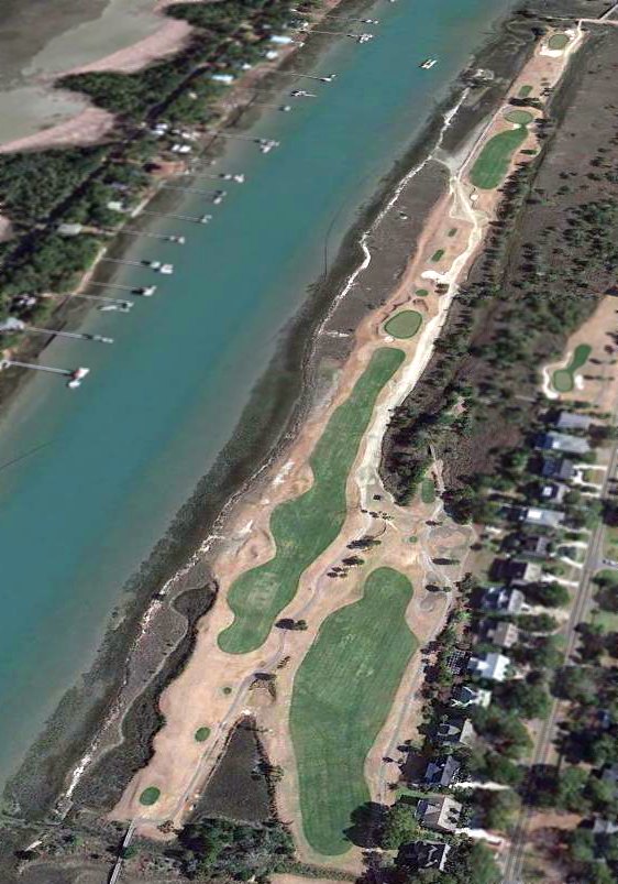
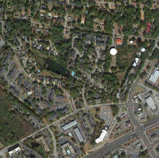
A 2/8/13 aerial view looking northeast showed a golf course covering the site of Isle of Palms Airport.
The site of Isle of Palms Airport is located North of the intersection of Waterway Boulevard & 31st Avenue.
Thanks to Thomas Page for pointing out this airfield.
____________________________________________________
Pinckney Airport / Remleys Point Airport, Mount Pleasant, SC
32.807, -79.896 (East of Charleston, SC)
An undated aerial view looking west at Remleys Point Airport from a circa 1957 SC Airport Directory (courtesy of Don Fraser).
According to the article “Pinckney’s Passion Remembering Mount Pleasant’s First Airport” in the 2022 Mt Pleasant Magazine (courtesy of David Austin),
“Mount Pleasant’s first airport was located at Remley’s Point.
The Remley’s Point Airfield, with its 3 grassy unpaved runways, was conceived by Charlestonian Warren Pinckney, the first Black man in the state to become a private licensed pilot.
In 1948, Pinckney traded 40 acres of land he owned west of the Ashley for a 4-passenger plane. He subsequently cleared his property at Remley’s Point to keep his own plane & 6 others belonging to local pilots.
Visiting small aircraft occasionally used the airfield as well. According to Mount Pleasant historian Ed Lee, the small airport was used most of all by 'well to-do folks.'
The airfield was a passion - but not a profession - for Pinckney. Pinckney engaged retired Civil Air Patrol Major William North to manage the airfield. As Pinckney’s business partner, he repaired small planes at the airfield.”
No airport was yet depicted at this location on the 1948 USGS topo map.
According to the Charleston International Airport website (courtesy of Thomas Page),
“Major William North operated the Remley’s Point Airport from about 1950.
Major North’s first wife is credited with being the first licensed female pilot in South Carolina.”
No airport was yet depicted at this location on the 1950 or 1955 Savannah Sectional Chart.
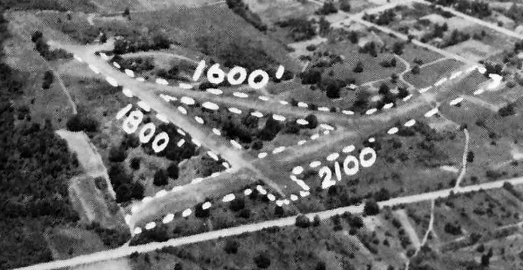
The earliest depiction which has been located of Remleys Point Airport was an undated aerial view from a circa 1957 SC Airport Directory (courtesy of Don Fraser).
It depicted Remleys Point Airport as having 3 unpaved runways, with a small building on the northwest side,
and listed the manager & owner as W.O. Pickney, and the operator as W.W. North.
A 3/11/57 USGS aerial photo depicted Pinckney Airport as having 3 unpaved runways, with 5 single-engine aircraft parked near a small building on the northwest side.
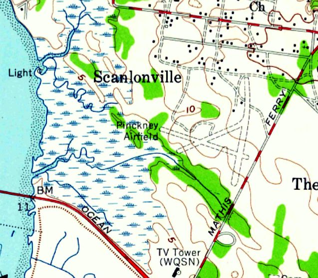
The earliest topo map depiction which has been located of Pinckney Airport was on the 1958 USGS topo map.
It depicted “Pinckney Airfield” as having 3 unpaved runways, with 2 small buildings on the north side.
The airport was evidently renamed Remleys Point Airport at some point between 1958-59,
as the 1959 Savannah Sectional Chart depicted Remleys Point as having an 1,900' unpaved runway.
According to the article “Pinckney’s Passion Remembering Mount Pleasant’s First Airport” in the 2022 Mt Pleasant Magazine (courtesy of David Austin),
“William North’s claim to fame was for his many local rescue missions during the 1950s & 1960s.
Major North was the man to call when a friend or family member went missing on one of the region’s many waterways - day or night.
At his own expense and with his own plane (which he of course kept at Remley’s Point Airfield), North located countless stranded or lost boaters, then radioed the Coast Guard for their rescue.
Even the Army used Pinckney’s airstrip several times in support of the National Guard armory on Mathis Ferry Road.
One of the most famous travelers to use the airfield was Santa Claus. Old Saint Nick landed at Remley’s Point just prior to his appearance in the 1963 Mount Pleasant Christmas Parade.”
The 1968 USGS topo map still labeled it as “Pinckney Airfield”.
The last aeronautical chart depiction which has been located of Remleys Point Airport was on the September 1970 Charlotte Sectional Chart (courtesy of Ron Plante).
It depicted Remleys Point as having an 1,800' unpaved runway.
The last photo which has been located showing Remleys Point Airport in operation was on a 12/28/71 USGS aerial view.
The runways were still clear, but only a single aircraft remained parked on the west side of the field.
The 1973 USGS topo map labeled it as “Remley Point Airport”.
According to the article “Pinckney’s Passion Remembering Mount Pleasant’s First Airport” in the 2022 Mt Pleasant Magazine (courtesy of David Austin),
“After the deaths of Pinckney & North within a year of each other, Remley’s Point Airfield closed in 1973.
Years earlier, Pinckney had told a local newspaper reporter he hoped that someday the airfield would become widely used & that a new owner might add hangars & other facilities.
But, he acknowledged, it might just as likely end up being 'plowed under & planted.'”

The last photo which has been located showing any trace of Remleys Point Airport was on a 1978 aerial view (courtesy of Thomas Page).
The outline of the runways was still recognizable, though deteriorated.
The 1979 USGS topo map no longer depicted Remleys Point Airport at all.
The outline of the northwest portion of one Remleys Point Airport runway was still visible in a 1989 USGS aerial photo,
though the majority of the airport site had been covered by houses & other buildings.
Remleys Point Airport was no longer depicted on the February 1994 Charlotte Sectional Chart.
A 2/8/13 aerial photo showed no trace remaining of Remleys Point Airport.
According to the article “Pinckney’s Passion Remembering Mount Pleasant’s First Airport” in the 2022 Mt Pleasant Magazine (courtesy of David Austin),
“Today, any hint of the airfield located between 7th Avenue & Wingo Way has since been erased by residential & commercial development. Fortunately, its history has not been forgotten.”
The site of Remleys Point Airport is located at the intersection of Wingo Way & Alexandra Drive.
Thanks to Thomas Page for pointing out this airfield.
____________________________________________________
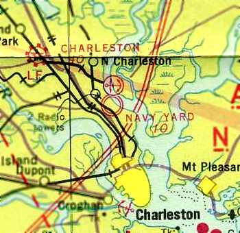
Charleston Navy Yard Field (1st location), North Charleston, SC
32.86, -79.96 (North of Charleston, SC)
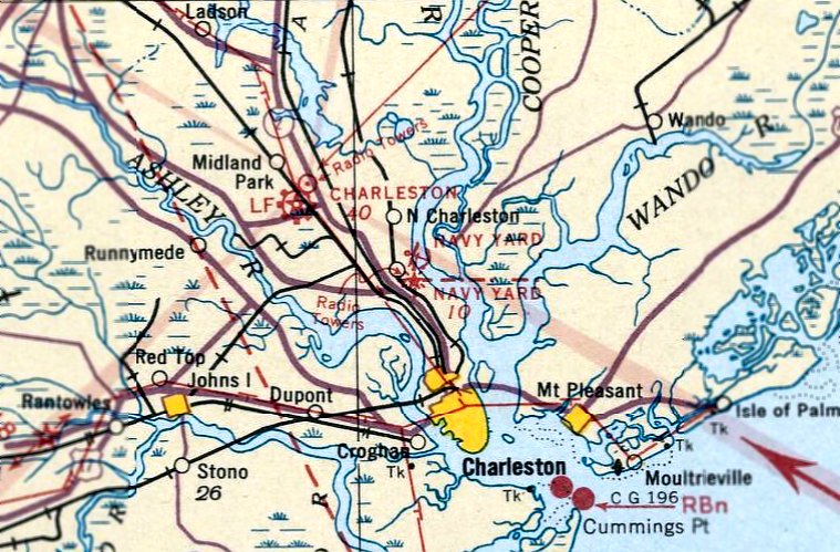
The Charleston Navy Yard Seaplane Base, as depicted on the January 1935 Savannah Sectional Chart.
An aviation training school for pilots & mechanics was established
along the banks of the Cooper River on the south end of the Charleston Navy Yard during WW1.
The air station was reportedly closed at the end of WW1.
However, the Charleston "Navy Yard Auxiliary Field" was still listed among active airfields
in the 1934 Department of Commerce Airfield Directory (courtesy of Chris Kennedy).
It was described as having 2 sod runways: a 1,680' northwest/southeast strip & a 1,600' northeast/southwest strip.
A hangar was said to be located at the field.
The earliest depiction which has been located of aviation facilities at the Charleston Navy Yard was on the January 1935 Savannah Sectional Chart,
which depicted a seaplane base.
The earliest depiction which has been located of a landplane airfield at the Charleston Navy Yard
was on the September 1935 V-237 U. S. Navy Aviation Chart (courtesy of Chris Kennedy).

A diagram of the Charleston “Navy Yard Field” from the September 1935 V-237 U. S. Navy Aviation Chart (courtesy of Chris Kennedy)
depicted the field as having 2 sod runways, measuring 1,680' & 1,600'.
An aerial photo on the back of the chart looking northeast at the airfield
depicted an open grass area with multiple buildings along the north side of the field.
The Coast Guard established an air patrol detachment at the former Navy facility in 1937,
and then commissioned Charleston Coast Guard Air Station in 1939.
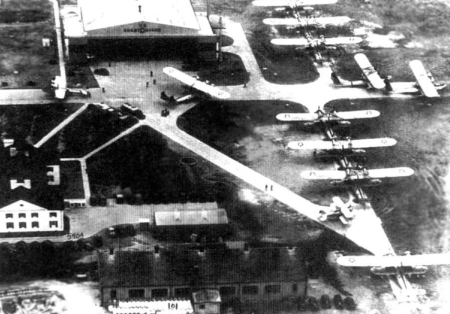
A circa 1939 photo of a large number of seaplanes at the Coast Guard ramp at Charleston (courtesy of George Miller).
The building in the center foreground is #101, the Torpedo Warehouse.
The building at left, #590A, used at the time as a Coast Guard barracks, still exists today.
The last aeronautical chart depiction which has been located of the Charleston Navy Yard Field in its original location
was on the November 1940 Savannah Sectional Chart (courtesy of Chris Kennedy).
The Charleston Navy Yard Field was evidently abandoned at some point between 1940-41,
as no airfield was depicted on the Navy Yard on the November 1941 Savannah Sectional Chart (according to Chris Kennedy).
[Note that this earlier field was eventually replaced by a somewhat larger airfield 1.5 miles to the southeast].
By the time of a 1957 aerial photo, the site of the original Charleston Navy Yard Airfield had been covered by numerous buildings.
The Charleston Navy Yard was recommended for closure by the 1993 BRAC.
The facilities were privatized, and turned over to the Detyens Shipyards in 1993.
A 3/1/14 aerial photo showed the site of the original Charleston Navy Yard Airfield to be covered by numerous buildings.
Note the cross-shaped building adjacent to the north side of the airfield property, which was also depicted on the 1935 diagram.
It is not known if any of the airfield hangars remain standing.
The site of the original Charleston Navy Yard Airfield is located at the intersection of North Hobson Avenue & Necessary Lane.
____________________________________________________
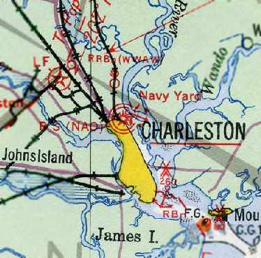
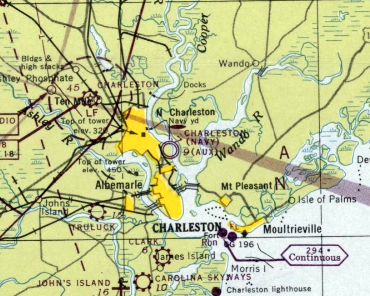
Charleston Naval Air Station (2nd location), North Charleston, SC
32.847, -79.94 (North of Charleston, SC)
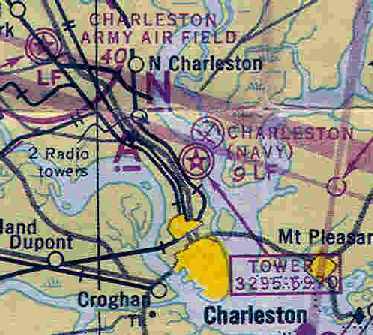
The "Charleston (Navy)" airfield & seaplane base, as depicted on the 1943 Savannah Sectional Chart (courtesy of Chris Kennedy).
After the start of WW2, the Coast Guard presence at the Charleston Navy Yard Airfield was replaced by the Navy.
A larger airfield facility was constructed by the Navy approximately 1.5 miles southeast of the former location,
to support a squadron of 12 seaplanes & 2 blimps.
Naval Air Station Charleston was commissioned in 1942.
The earliest depiction which has been located of Naval Air Station Charleston
was on the 1943 Savannah Sectional Chart (courtesy of Chris Kennedy).
During the war, PBY & PBM seaplanes from Jacksonville flew operational patrols from Charleston.
ZP-15 from Glynco NAS maintained a continuous detachment of 1 or 2 blimps that flew daily ASW patrols.
In 1944, the station complement consisted of a total of 886 personnel.
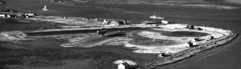
A WW2-era National Archives photo, looking north at the runway at Charleston (note the blimp at the center of the picture).
The NAS Charleston airfield consisted of three 1,400' asphalt runways, 2 blimp mooring circles, and a seaplane hangar.
With such short runways, only very small or lightly loaded landplanes could operate from the facility.
Larger Navy aircraft were forced to operate from Charleston AAF, 4 miles away.
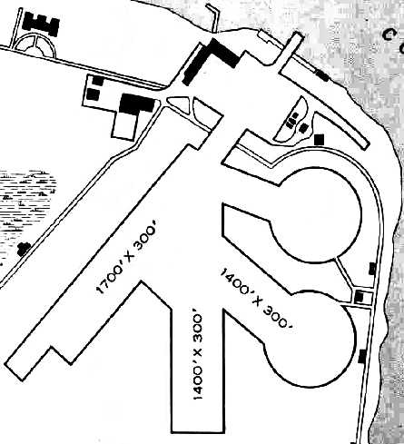
The 1945 AAF Airfield Directory (courtesy of Scott Murdock) described Charleston NAS
as consisting of a 528 acre triangular property containing 3 asphalt runways (with the longest being the 1,700' northeast/southwest strip) & 2 circular blimp mooring circles.
The field was said to have 2 hangars, the largest being a 120' x 100' steel & cinderblock structure.
Charleston NAS was owned by the U.S. Government, operated by the Navy, and had one auxiliary field: John's Island Outlying Field, 11 miles SSW.
The last aeronautical chart depiction which has been located of Naval Air Station Charleston was on the April 1947 Savannah Sectional Chart.
It no longer depicted a seaplane base, but still depicted “Charleston (Navy) (Aux)” as a land airfield with a blimp mooring mast.
Aviation operations at Charleston NAS apparently ended at some point in 1947,
as Charleston NAS was no longer depicted on the October 1947 Savannah Sectional Chart.
A 1957 aerial photo still showed the majority of the Charleston NAS site to remain clear.
In the late 1950s, new facilities for a Naval Mine Craft Base, Mine Warfare School, and Fleet Training Center
were built on the site of the former Charleston NAS.
The Charleston Navy Yard was recommended for closure by the 1993 BRAC.
The facilities were privatized, and turned over to the Detyens Shipyards in 1993.
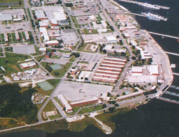
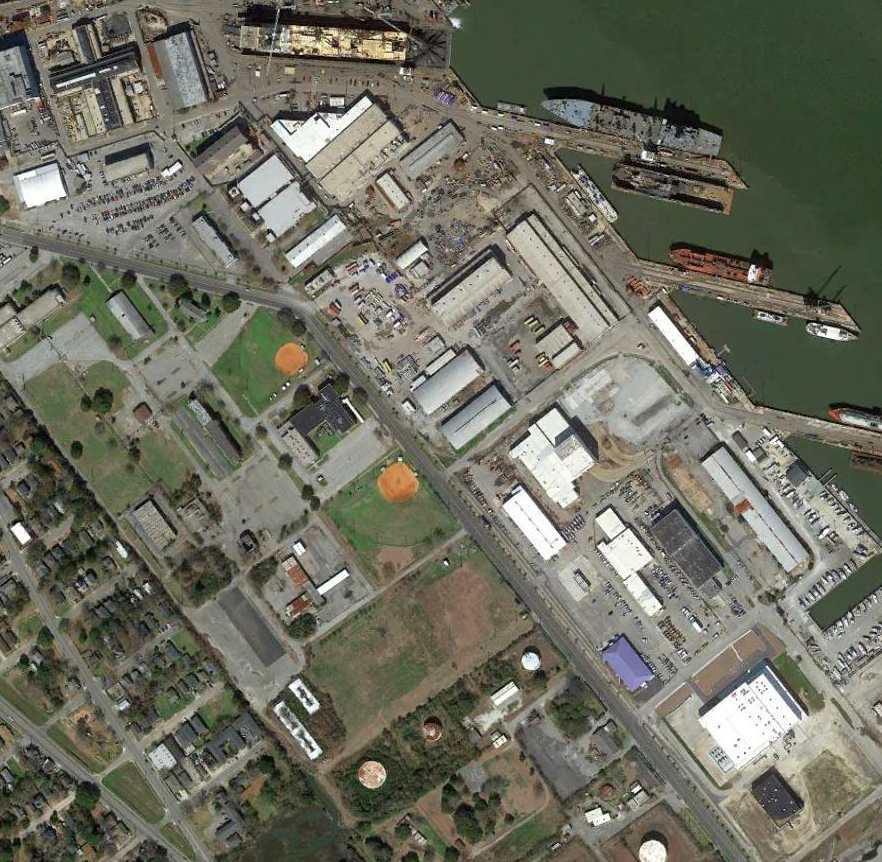
A 2000 aerial view looking northwest at the site of NAS Charleston.
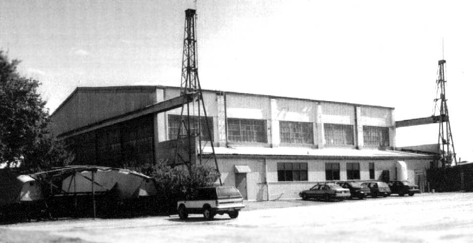
A 2002 photo by George Miller of an original hangar from Charleston NAS.
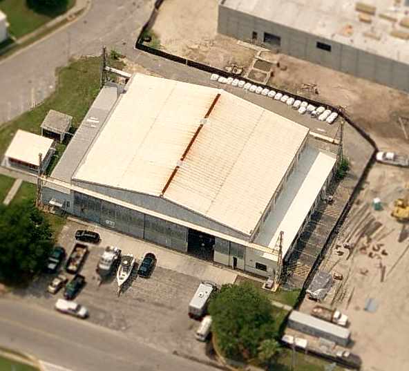
A circa 2006 aerial view looking south at the former hangar from Charleston NAS, which remains as the only trace of the former airfield.
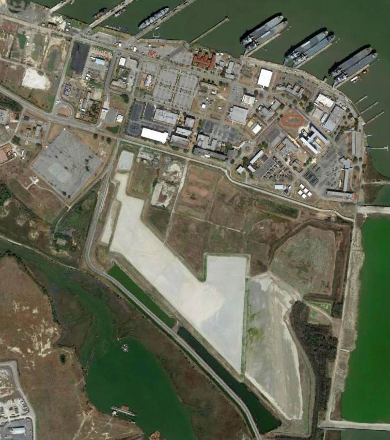
A 3/1/14 aerial view of the site of NAS Charleston.
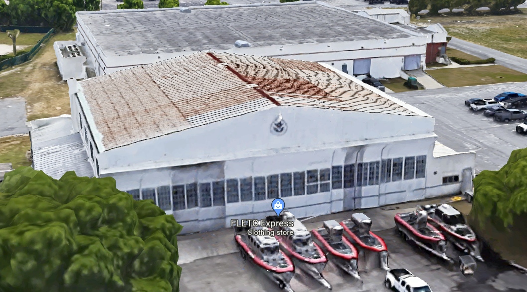
A 2022 3-D imagery view of the former Charleston NAS hangar.
As of 2022, street maps label the former Charleston NAS hangar as the FLETC Express retail store.
The site of NAS Charleston is located at the intersection of Juneau Avenue & Thompson Avenue.
____________________________________________________
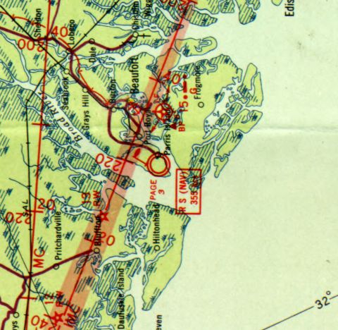
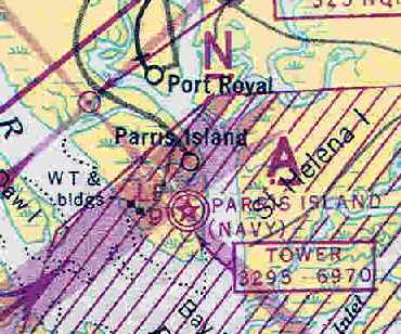
Parris Island Landing Field / Page Field Marine Corps Outer Landing Field, Parris Island, SC
32.32, -80.68 (South of Beaufort MCAS, SC)
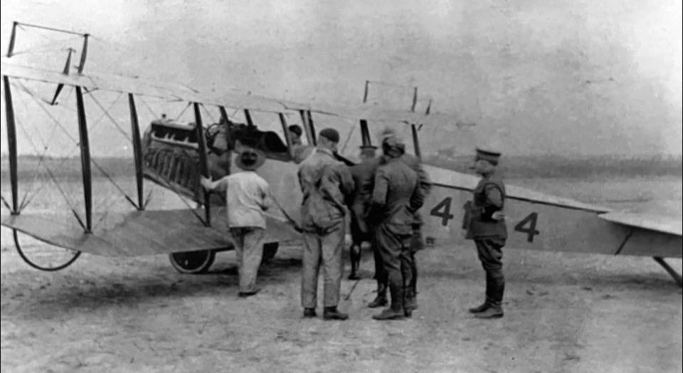
A 1919 photo of a DH-4 at Paris Island.
This airfield was located on the property of the Parris Island Marine Corps Base,
the Marine Corps' port of entry for Marine Recruits who live east of the Mississippi River.
An airfield was first constructed at Parris Island in 1919.
It was used to train Marine pilots to fly the Navy's DH-4 bombers,
and it was the home station of the aviation forces of the Atlantic Coast Advanced Base & Expeditionary Forces.
The earliest depiction which has been located of an aircraft at Paris Island was a 1919 photo of a DH-4 biplane.
The Paris Island airfield was closed in 1921 & abandoned by 1922.
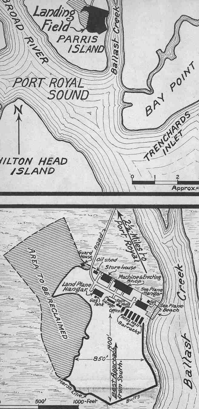
The earliest map depiction which has been located of Paris Island Landing Field was a circa 1928-30 Department of Commerce Airway Bulletin (courtesy of Tom Heitzman).
It depicted Paris Island as consisting of an unpaved irregularly-shaped field measuring 1,400' north/south,
with a landplane hangar, seaplane hangar, and seaplane ramp on the northeast side.
In the late 1920s an airship mooring mast was erected at Page Field.
Paris Island Landing Field was renamed Page Field in honor of USMC Captain Arthur Page,
who died in a 1930 crash of an XF6C-6 Hawk during the Thompson Trophy Race at Chicago.
According George Miller, during the 1930s, several metal hangars were relocated by the Marines from Nicaragua to Page Field.
Many were eventually torn down after being damaged by the many hurricanes to pass through coastal SC.
Paris Island's "Station Field, Marine Corps" was described in the 1934 Department of Commerce Airfield Directory (courtesy of Chris Kennedy)
as having two 2,000' sod runways, oriented east/west & north/south.
A mooring mast was said to be located on the northwest corner, and hangars were said to be located on the north side of the field.
The earliest aeronautical chart depiction which has been located of Page Field was on the 1936 DC to Savannah Airway Chart.
It depicted Page as a military airfield, and also depicted the field's airship mooring mast.
The November 1940 Savannah Sectional Chart (courtesy of Chris Kennedy)
continued to depicted Page Field along with its airship mooring mast.
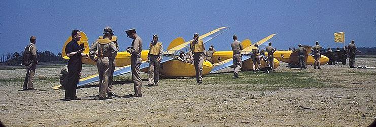
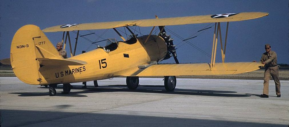
In 1942 the USMC established Marine Glider Group 71 at Page Field, using the Schweizer LNS-1 & Pratt-Read LNE-1
It later also used Aeronca LNR-1 gliders for training.
For towing the unit used N3N Canary biplane trainers & J2F Duck amphibians.
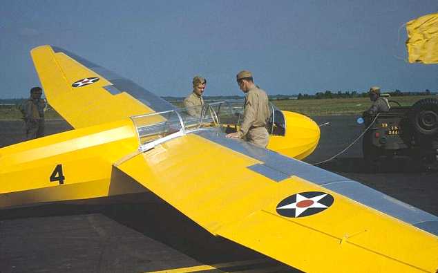
A May 1942 photo of an unidentified Marine Corps training glider at Page Field (courtesy of FFI).
A 1940s photo of an unidentified Marine Corps training gliders at Page Field.

A 1942 photo by Alfred Palmer of a Marine Corps glider at Page Field.
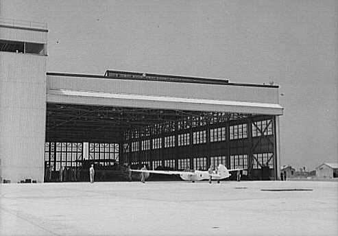
A 1942 photo by Alfred Palmer of a Marine Corps glider in front of a hangar at Page Field.
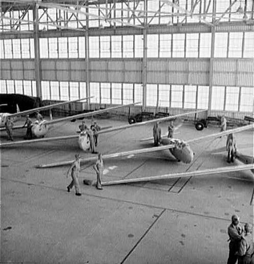
A 1942 photo by Alfred Palmer of Marine Corps glider inside the hangar at Page Field.
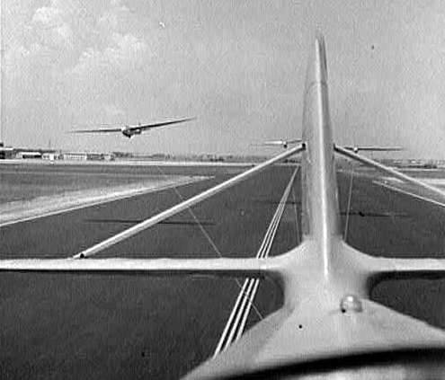
A 1942 photo by Alfred Palmer of Marine Corps gliders taking off from the runway at Page Field.
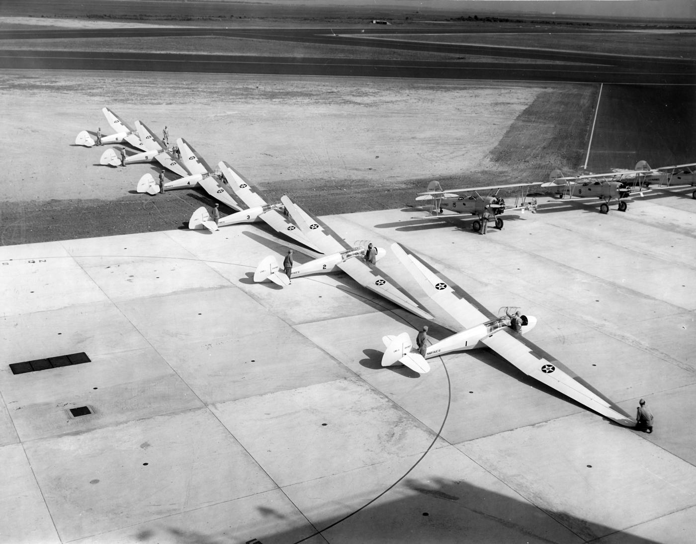
A May 1942 National Archives photo of Marine Corps gliders & biplanes at Page Field.
"Paris Island (Navy)", as depicted on the 1943 Savannah Sectional Chart (courtesy of Chris Kennedy).
A circa 1942-45 aerial view looking at Paris Island MCAS (Page Field) from the 1945 AAF Airfield Directory (courtesy of Scott Murdock)
showed that the field had been expanded considerably since 1934.
The directory described Page Field as a 750 acre irregularly-shaped property containing 4 asphalt runways, the longest being the 6,000' northeast/southwest strip.
The field was said to have 3 metal hangars, the largest having a 98' x 28' door opening.
The field was said to have 2 auxiliary fields: Georgetown County Outlying Field (11 miles northeast), and Hilton Head Island Outlying Field.

An undated (WW2-era?) aerial view looking northwest at Page Field (courtesy of George Miller).
Page Field was placed in a maintenance status in 1946.
However, it was still depicted as "MCAS Parris Island" on the 1949 Savannah Sectional Chart (according to Chris Kennedy),
and described as having a 6,000' hard-surface runway.

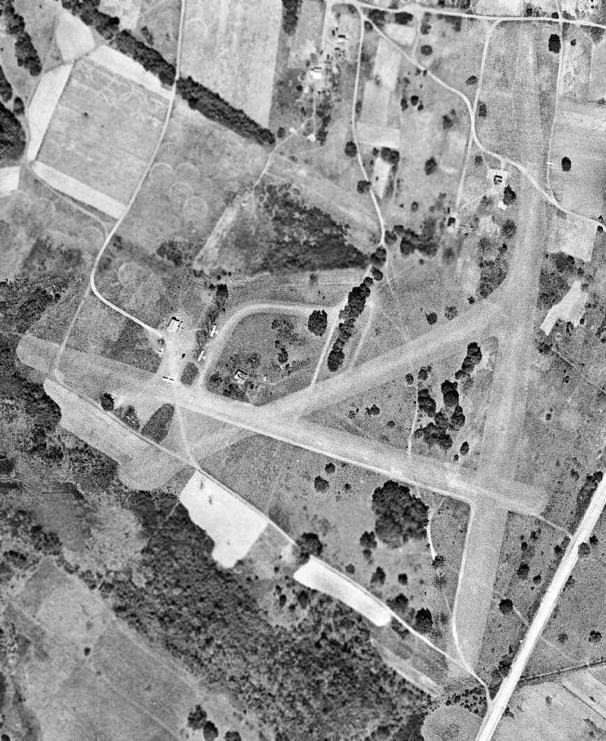
A 3/23/51 USGS aerial photo depicted Page Field as intact but without any aircraft on the field, and aAll 3 hangars remained standing.
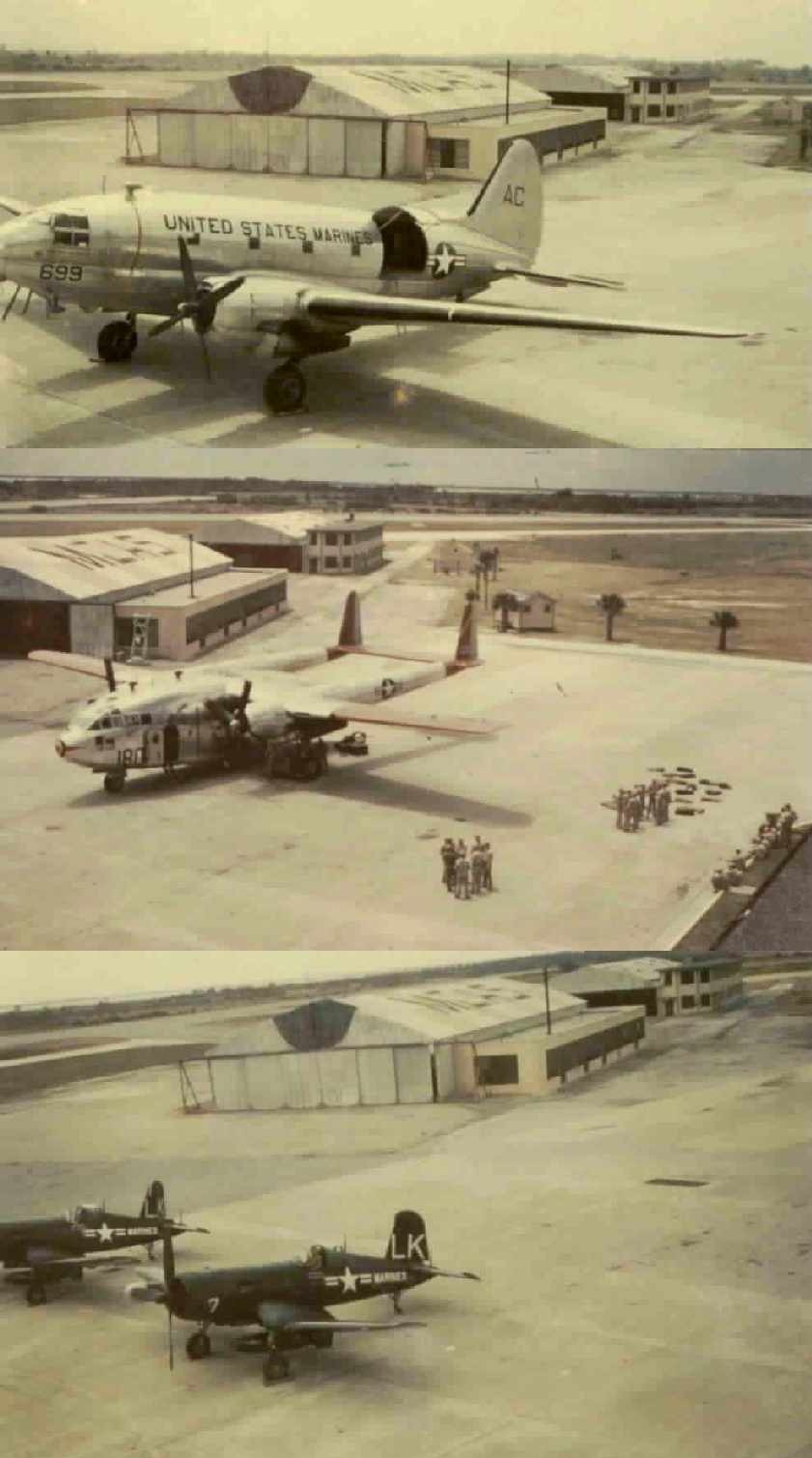
A series of circa 1952-53 photos by Kenneth Cutteridge of transient aircraft at Page Field: a Curtis R5C, Fairchild R4Q, and Chance-Vought F4Us.
“Some of the pilots that dropped in were Master Sergeants that had been in WW2 as officers.
The hangar on the left I believe was brought up to Page Field from Nicaragua. In 1952-53 we tore it down & they shipped it someplace else.”
Kenneth Cutteridge recalled, “I was stationed at Page Field from February 1952 - June 1953.
I was one of 7 Aviation Crash Crew Firefighters there. We were caretakers of the field (800 acres) and stood by with our fire trucks when a plane landed.
My 3 years in the Marine Corps were the best years of my life.”
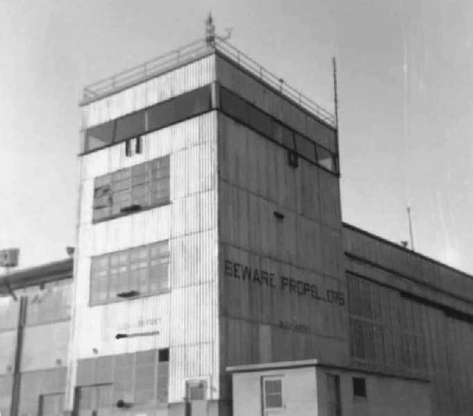
A series of circa 1952-53 photos by Kenneth Cutteridge of the Control Tower on the southeast corner of Page Field's main hangar.
“On the sunny side of the tower was marked, '11.5 feet above sea level.'”
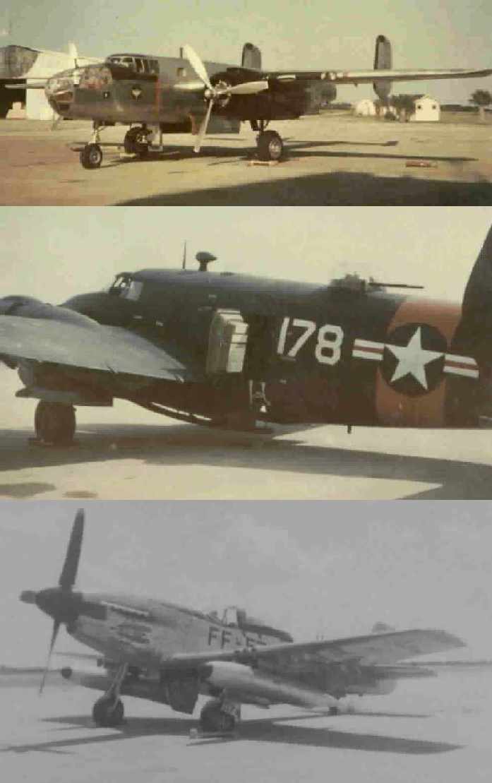
A series of circa 1952-53 photos by Kenneth Cutteridge of transient aircraft at Page Field: a B-25 Mitchell, Lockheed PV-2, and a F-51 Mustang.
A 1955 aerial photo showed the middle Page Field hangar had been removed at some point between 1951-55.
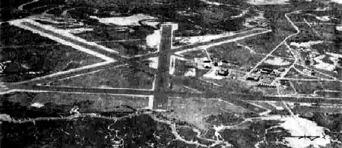
The 1956 USGS topo map depicted Page Field as having 4 runways, taxiways, a few buildings (including 2 remaining hangars), and a tower.

The last aeronautical chart depiction which has been located of the Parris Island airfield was on the July 1959 Savannah Sectional Chart.
It depicted “Parris Island ALF (Navy)” as having a 6,000' paved runway.
Page Field was evidently closed at some point between 1959-60,
as the February 1960 Savannah Sectional Chart (courtesy of Chris Kennedy) labeled the field as “Parris Island ALF (Navy) (Closed)”.
It depicted the field as having a 6,000' paved runway.
The Aerodromes table on the 1964 Savannah Sectional Chart (courtesy of John Voss)
described "OLF Parris Island (Navy) (Closed)" as having 4 bituminous runways, with the longest being 6,000'.

A 4/16/68 USGS aerial photo showed that Page Field's western hangar had been removed at some point between 1955-68, leaving only the northeast hangar.
Paris Island firefighter Dan Powers reported, “After Page Field closed,
my father said he remembered aircraft from MCAS Beaufort still did 'touch-n-gos' there until the early 1960s, including the first jets.
While hiking on Paris Island I have found old metal signs in the woods stating when the pine was planted: around the late 1960s / early 1970s.”
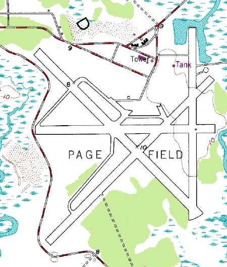
The 1983 USGS topo map depicted the 4 runways, taxiways, a few buildings, and a tower at Page Field.
An undated photo (courtesy of George Miller) of Page Field's former headquarters building (possibly a former hangar?), now gone.
A 1983 aerial photo showed that Page Field's last hangar had been removed at some point between 1968-83.
The 1994 USGS aerial photo showed Page Field's 4 concrete runways (the longest being 6,200' long) still existed in quite good condition.
According to Paris Island firefighter Dan Powers, “In the mid-1990s, an older lady emergency-landed here when her plane ran out of gas on the way to Hilton Head.
I got her gas & she took of the next day.”
According to Aaron Gould (who spent 13 weeks aboard Parris Island), there is evidence of one abandoned hangar which is now used to store recruit training equipment.
There is currently an amphibious tractor, a tank, and a wooden mock up of a CH-46 helicopter on one of the runways.
One of the runways sustained some damage when it was used as the grenade range, but the marks are mostly gone.
Today, the Page Field property is used mostly for Marine recruit training exercises.
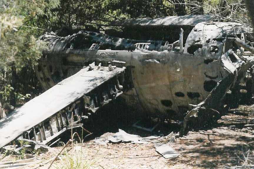
A 1999 photo by Matt Lockman of the remains of a Brewster SB2A Buccaneer which crashed on approach to Page Field in 1943.
Matt reported, “An interesting side note: The Parris Island golf course is southeast of the airfield.
Behind the club house is the entrance to a nature trail that meanders through the very southern tip of Parris Island.
Along the trail lie the remains of a Brewster SB2A Buccaneer that crashed on approach to Page Field during WWII.
The wreckage lies upside-down & is pretty crumpled & weather-worn back down to bare metal.”
Matt Lockman reported, “There remains (as of 2001) a concrete & bronze plaque/marker at the entrance to Page Field at the corner of Cuba & Henderson Streets.
The plaque identifies whom the field was named after and what activities took place there, primarily focusing on pre-WWII.
A handful of vintage Quonset huts are scattered about the area & are used to store equipment & training devices.”
Matt continued, “The entire area of the former airfield is contained in the Field Training Unit’s area of operations & is used to conduct portions of USMC recruit training.
A grenade range is located to the northeast of the runways on a separate small island.
A tear gas chamber is located near where the airfield HQ building once stood. A company office & rappelling tower is located nearby.
Much of the airfield has been crowded in by loblolly pine & palmetto bushes
and the complex of runways & surrounding landscape, as well as its remoteness from the main base, is well suited for day & night land navigation training.
The asphalt runways are not maintained and are showing evidence of decay.
Various training devices have been erected throughout including a plywood mock-up of a CH-46 helicopter, pull-up bars, bleachers, and an obstacle course.
There used to be a derelict M48 tank at the far end of one of the runways,
visible from Belleau Wood Street, but was removed in 1998 (?) at the request of the Army for one of their museums.
Some pieces of Soviet armor captured in Desert Storm were also on display,
but I believe these were also removed & distributed to units at Camp Lejeune, NC and Quantico, VA as training devices.
The area also contains a bayonet assault course, combat assault course, and other training sites.”
Paris Island firefighter Dan Powers reported, “After 9/11/01, the woods around the runways were cut back & they found the partial wreckage of a DC-3.”
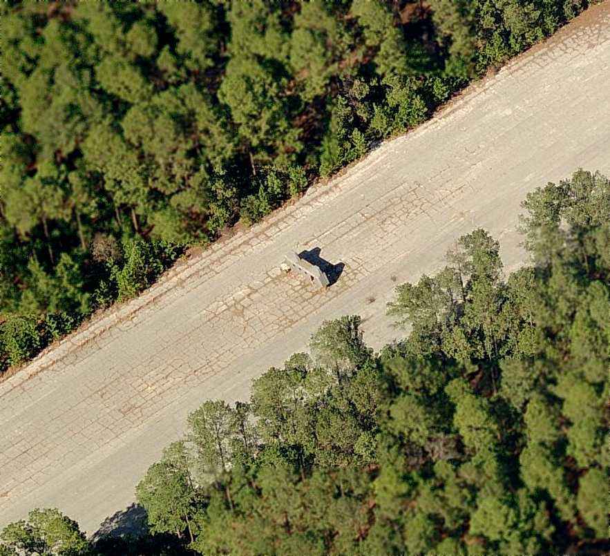
A circa 2006 aerial view looking north at the only “aircraft” which remains on the runways at Page Field -
a plywood mockup of a CH-46 helicopter fuselage on the northeast/southwest runway.
Paris Island firefighter Dan Powers reported in 2010, “Another interesting area I found was a bombing range in the sandy marsh near what is now the golf course.
As a former ordnanceman, I new exactly what it was when I first saw it.
It was simply 2 upright steel girders, one fallen down, that presumedly had something strung between them,
and rusted lumps of twisted metal in the wet tidal sand all around.
These were bombs, since some still had small traces of blue paint - the color of 'dummy', or practice, bombs.
These were hollow but usually filled with water as you could tell they had impacted hard enough to burst them. They were about 3-4' long.”
Dan continued, “There is also a 'corduroy' road made of logs still in the sand,
and some remnants of asphalt that appeared to have been added later.
I understand it was the road to the old wooden lighthouse, that was at the south end of the island,
but was used for the bombing range road when the lighthouse was taken down,
around the time the first biplanes were stationed at Page Field.
The man-made mounds that cover the old aviation fuel bunkers are still there also, near the recruit gas chamber.
The concrete seaplane ramp, that serviced the one or two Grumman JSF Ducks that were stationed here,
is still there near the old marina, which used to hold the sailboats of officers, but has long since filled with mud,
as has the drydock, where battleships once fueled and repaired.
Chunks of coal can still be found along the water there.
The dirt road to the airship field of the thirties is all but gone, taken over by the marsh, which has taken over much of Parris Island,
but I am always fascinated when I find sidewalks, plates ('1917 USMC'),
or even porcelain electric fence insulators (for livestock during the depression) in the middle of nowhere.
The runways still stand out from the pine.”
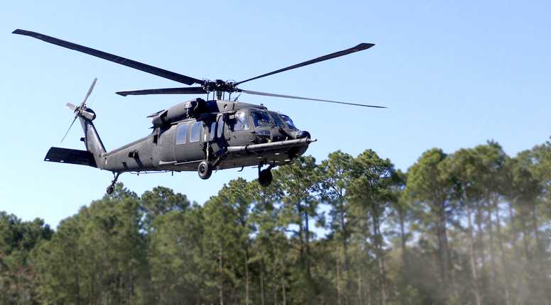
A March 2010 photo by Erin M. of an Army MH-60 Blackhawk conducting special operations training at Page Field.
An article entitled “Elite soldiers train with Black Hawks on Parris Island” by Patrick Donohue appeared in the 3/21/10 issue of the Beaufort Gazette:
“The rustic conditions of an abandoned World War II-era airfield on Parris Island
attracted an elite Army special operations unit to the Lowcountry over the weekend to train its helicopter pilots.
Traveling with 3 MH-60 Black Hawk helicopters, soldiers from the 160th Special Operations Aviation Regiment (Airborne)
touched down Friday at Page Field to begin preparing for 2 days of offshore training.
Nicknamed 'The Night Stalkers', the unit is based in Fort Campbell, Ky., and specializes in attack, assault & reconnaissance missions usually conducted at night.
The regiment comprises 4 battalions, including one at Hunter Army Airfield near Savannah.”
The article continued, “Two by two, the unit's helicopter pilots will be taken at least 100 miles offshore & left to navigate back to Page Field in the dark.
Page Field once served as the home of Marine Corps Air Station Parris Island and has been abandoned since 1947.
We like to use this target because it's very difficult to find," said Hal, an Army chief warrant officer & one of the unit's Black Hawk pilots.
"You can't go anywhere in this area and be more than like 5 feet above sea level," he joked.
"So it's basically one big table top & cut into these 100-foot pines is this runway, which isn't lit.
If you didn't do your mission planning properly, you'd never find it."

A 5/6/12 photo by Mike Legeros of a historical sign in front of the wreckage of a Brewster SB2A Buccaneer, “on a nature trail near golf course.
[It] crashed about a half-mile north in 1943, and was towed to this location.”
A 5/6/12 photo by Mike Legeros of fire department training equipment on the remains of a Page Field runway (note the faded closed-runway yellow “X” in the foreground).
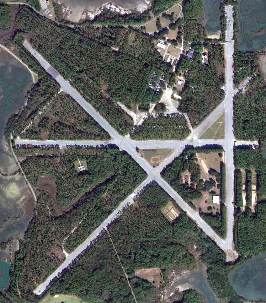
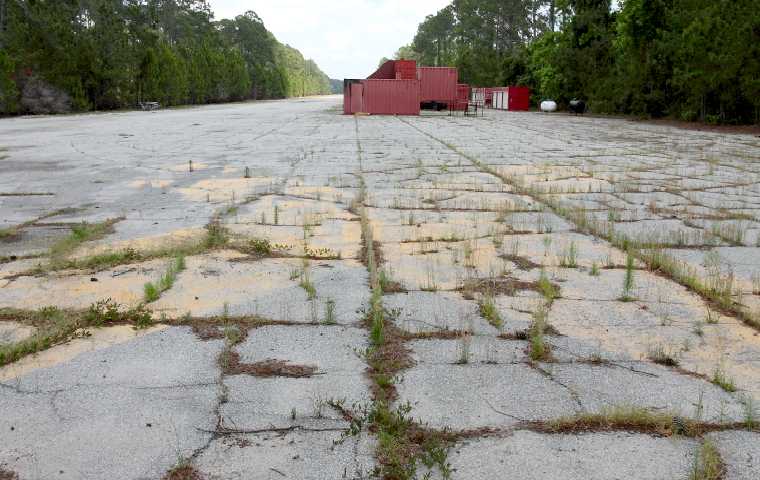
A 11/1/12 aerial view of Page Field showed the 4 concrete runways still remained in quite good condition.
There were also foundations from numerous buildings just north of the airfield.
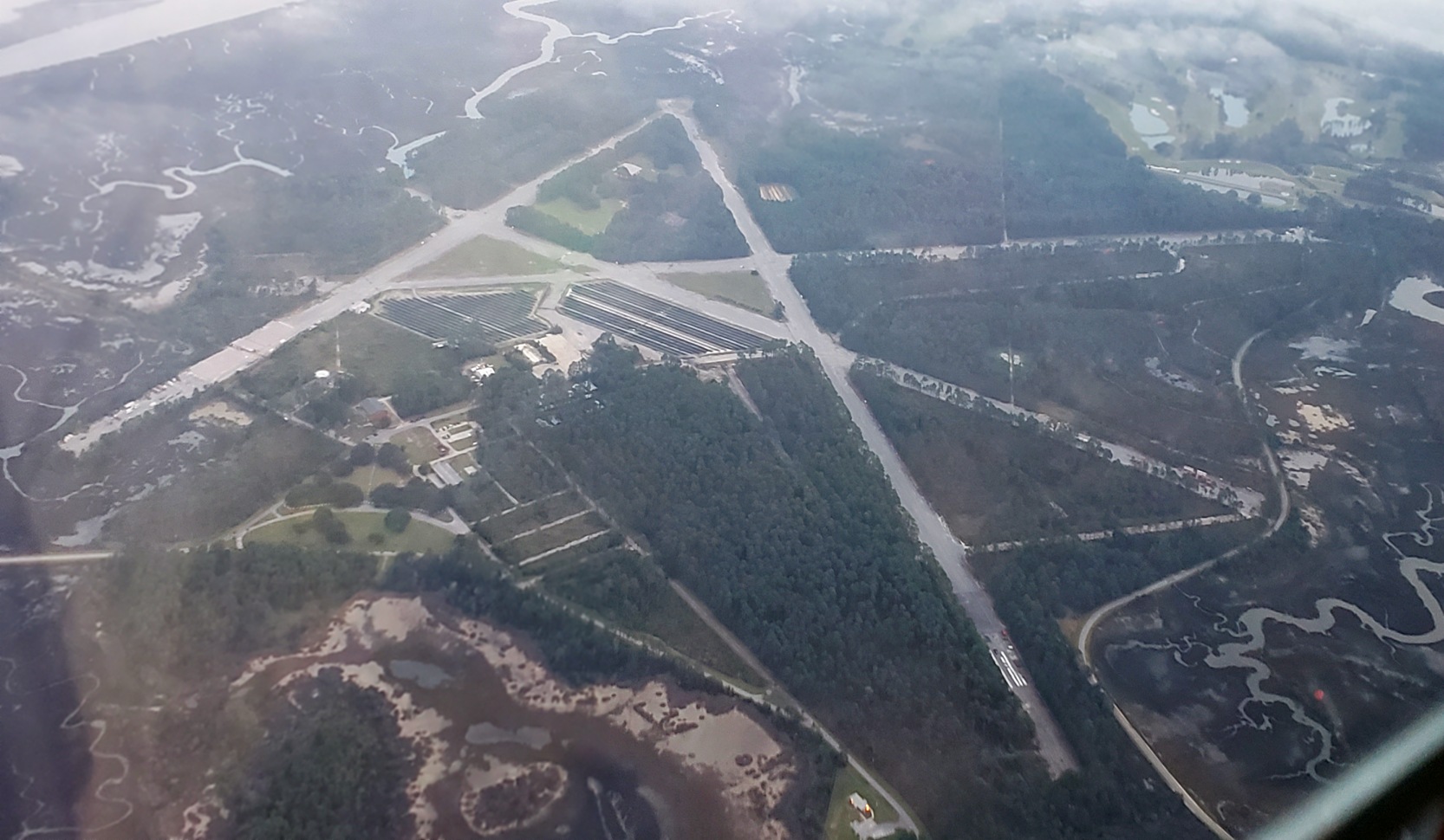
An 11/7/18 aerial view by Alex Melia looking southeast at Page Field showed the 4 concrete runways still remained in quite good condition.
It appears an array of solar cells had been installed north of the runway intersection.
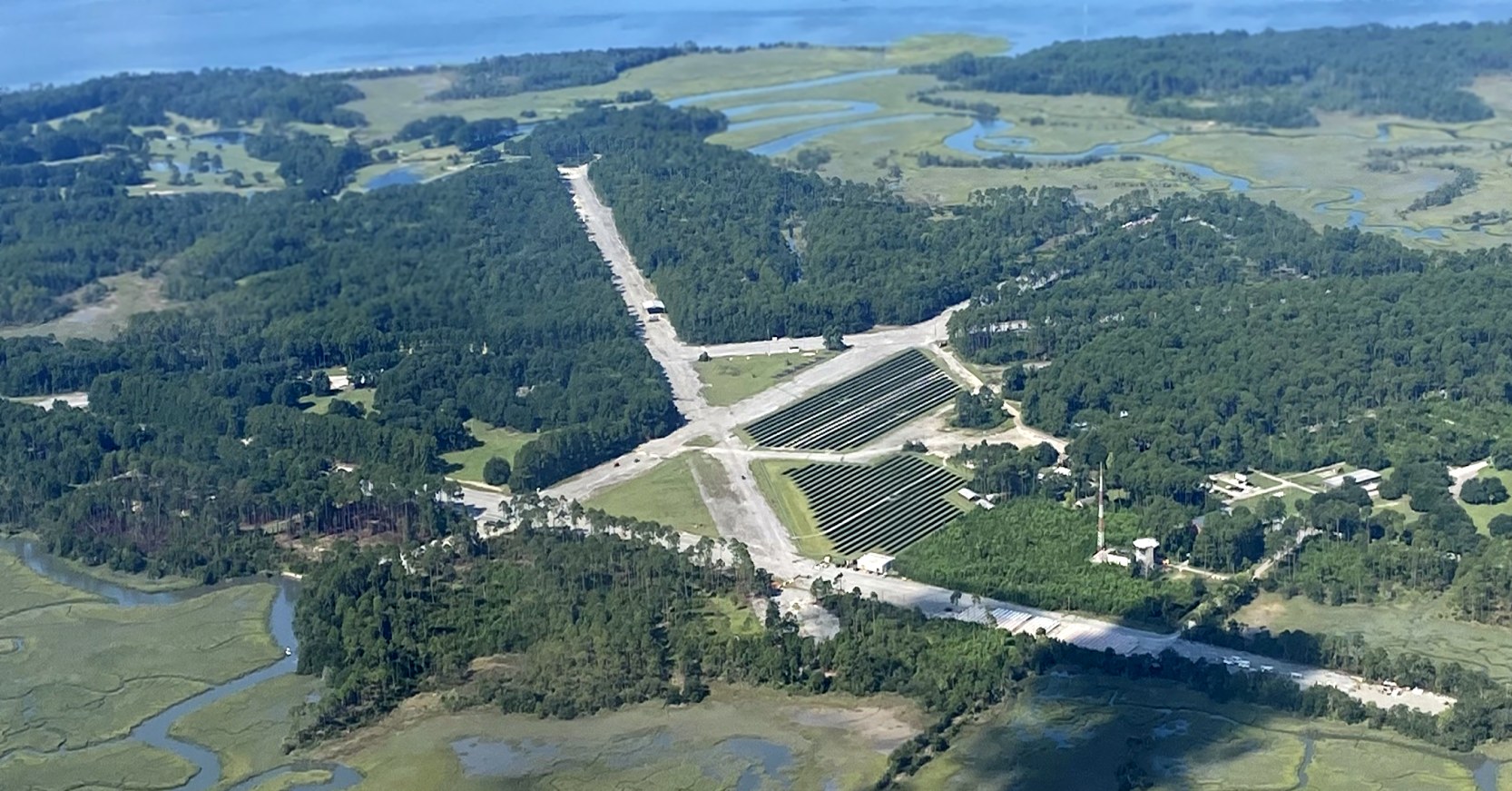
An 8/11/21 aerial view by Phil Brooks looking southwest at Page Field.
Page Field is located at the southern end of Henderson Street.
____________________________________________________
Or if you prefer to contact me directly concerning a contribution (for a mailing address to send a check),
please contact me at: paulandterryfreeman@gmail.com
If you enjoy this web site, please support it with a financial contribution.
____________________________________________________
This site covers airfields in all 50 states.