
Abandoned & Little-Known Airfields:
Central Tennessee
© 2002, © 2025 by Paul Freeman. Revised 9/9/25.
____________________________________________________
Please consider a financial contribution to support the continued growth & operation of this site.
Blackwood Field (revised 2/8/17) - Camp Tyson (revised 11/20/20) - Cornelia Fort Airport / Cornelia Fort Airpark (revised 9/9/25)
Franklin-Wilkins Airport / Lexington Airport (revised 11/20/23) - Ft. Campbell Sky Drop Army Airfield (revised 5/16/15) - Gillespie Field / Cumberland Airport (revised 5/9/21)
Humphreys County Airport / Waverly Airport (revised 1/19/17) - McConnell Field (revised 6/18/19) - Nashville Police Airfield (revised 9/9/25)
Parsons Municipal Airport / Scott Field (revised 2/2/22) - Sky Harbor Airport (revised 11/20/23) - State Teachers College Airport (revised 1/20/25)
____________________________________________________
Nashville Police Airfield (47TN), Nashville, TN
36.209, -86.829 (Northwest of Downtown Nashville, TN)
The Nashville Police Airfield, as depicted on the 1986 St. Louis Sectional Chart (courtesy of Johnathan Westerling).
According to a Hell Ops Magazine article, the Nashville Police Department first established an aviation unit in 1972.
Its first aircraft were helicopters but in the 1980s the department seized a Maule fixed-wing airplane during drug enforcement operations which was subsequently assigned to the air unit.
Between 1981-86 a new runway was paved behind the agency’s Training Center allowing fixed-wing operations.
The earliest aeronautical chart depiction which has been located of the Nashville Police Airfield was on the 1986 St. Louis Sectional Chart (courtesy of Jonathan Westerling).
It depicted the Nashville Police Airfield as having a single 1,600' paved southwest/northeast runway.
By 1989, the Nashville Police aviation unit operated 3 Bell 47s, a Bell JetRanger, and the Maule.
Two new MD500Es were ordered that year & they entered service in 1990, at which time the older machines were phased out.

An 1990 or later photograph of a Nashville Police MD500E hovering over the Nashille Police Airfield runway (courtesy of Jonathan Westerling).

The last aeronautical chart depiction which has been located of the Nashville Police Airfield was on the November 1991 St. Louis Sectional Chart.
It depicted the Nashville Police Airfield as having a single 1,600' paved southwest/northeast runway.

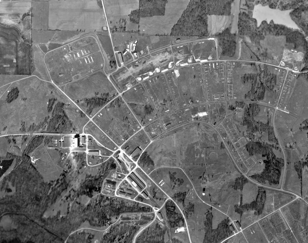
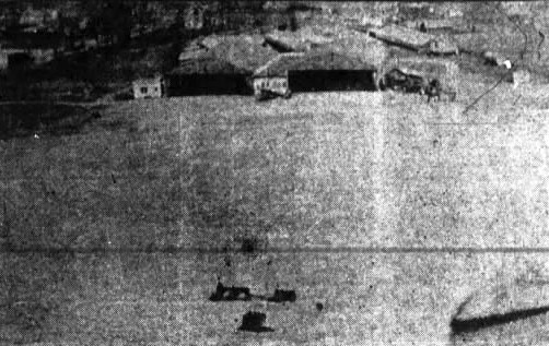
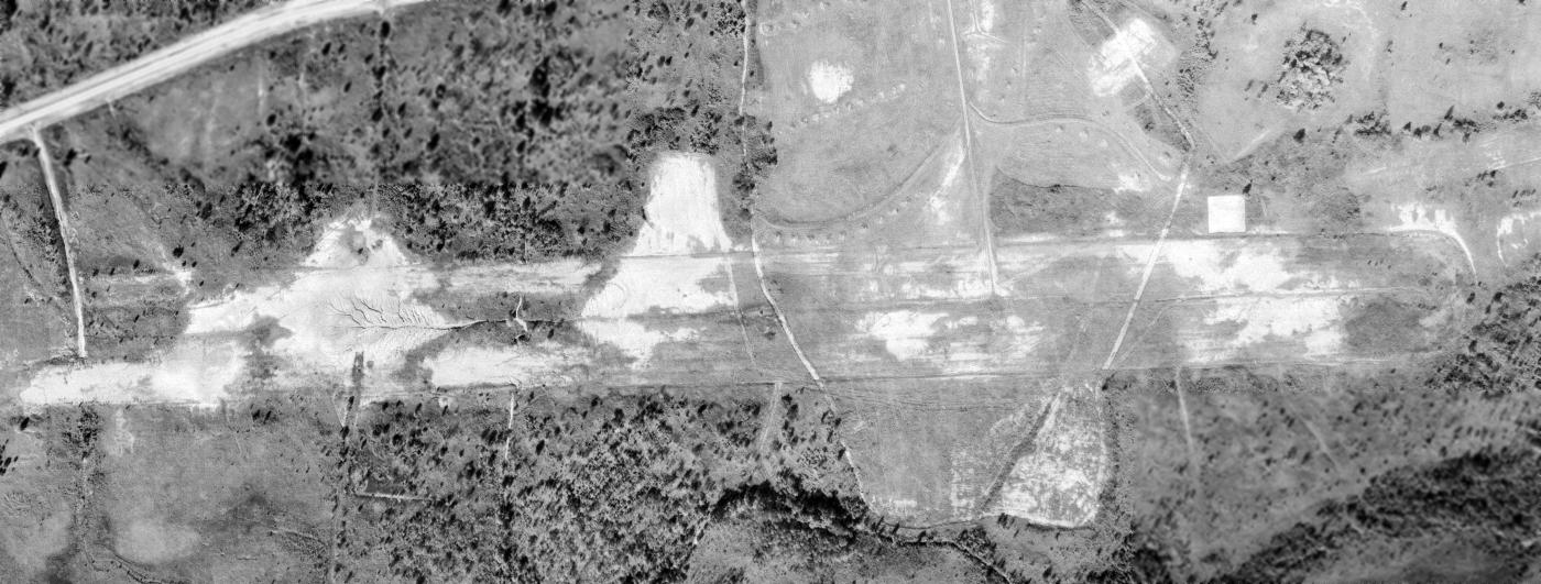
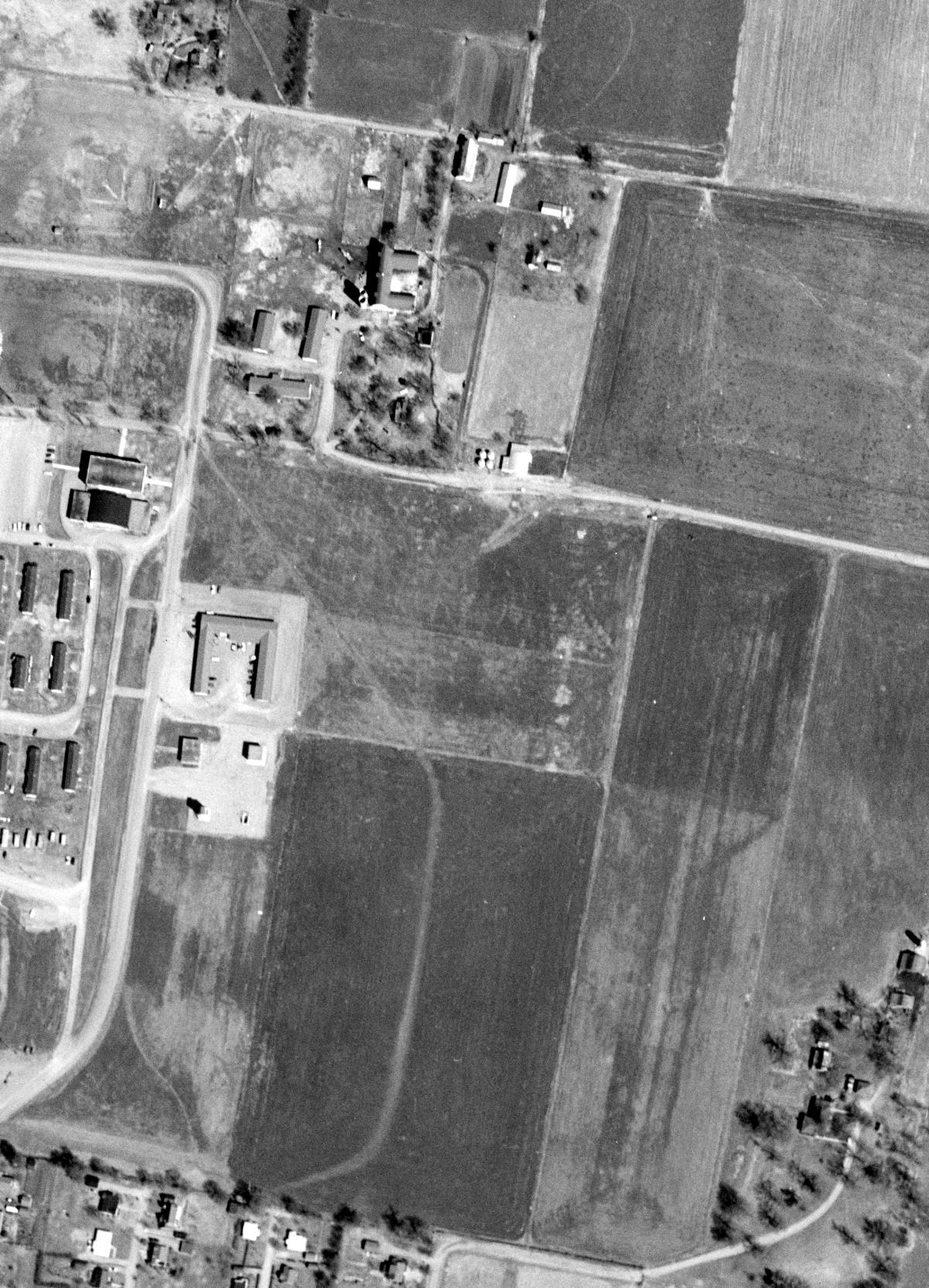
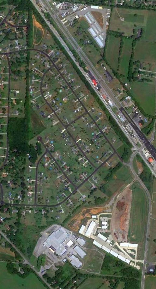
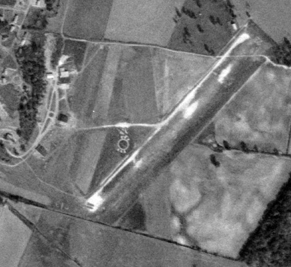
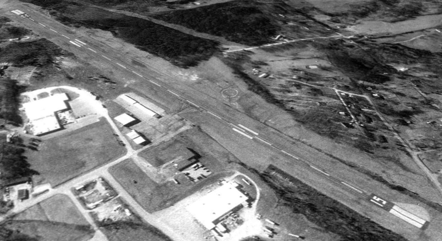
A 1992 aerial view looking northwest at the Nashville Police Airfield. The purpose of the unusual large paved area on the east end of the runway is unknown.
According to Jonathan Westerling, the Nashville Police Airfield “was shown on sectional charts until 1994
but was presumably closed to fixed wing operations after that as it was not shown on Sectional Charts after 1995.”

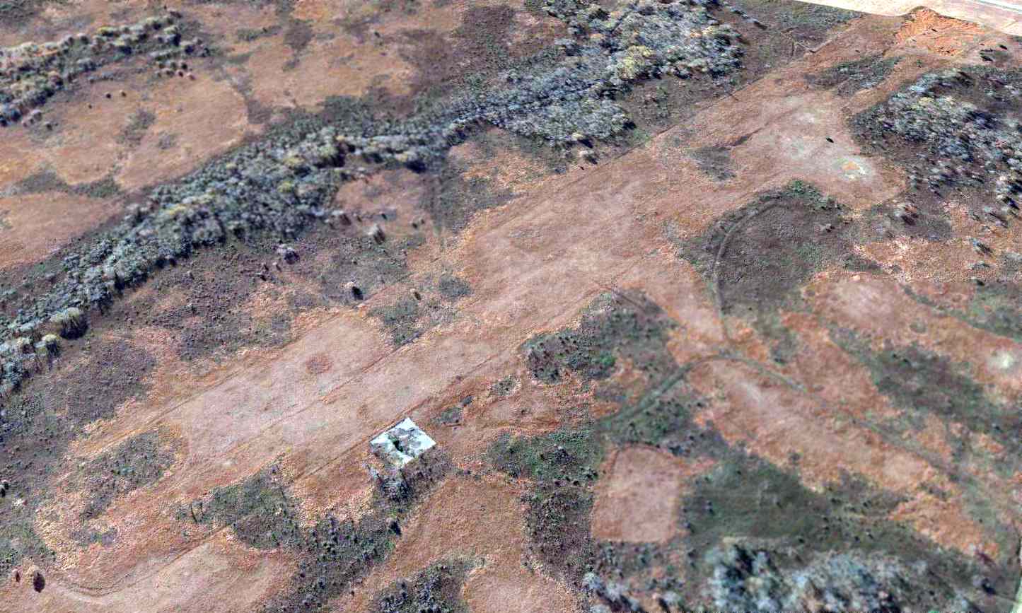
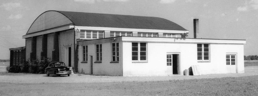
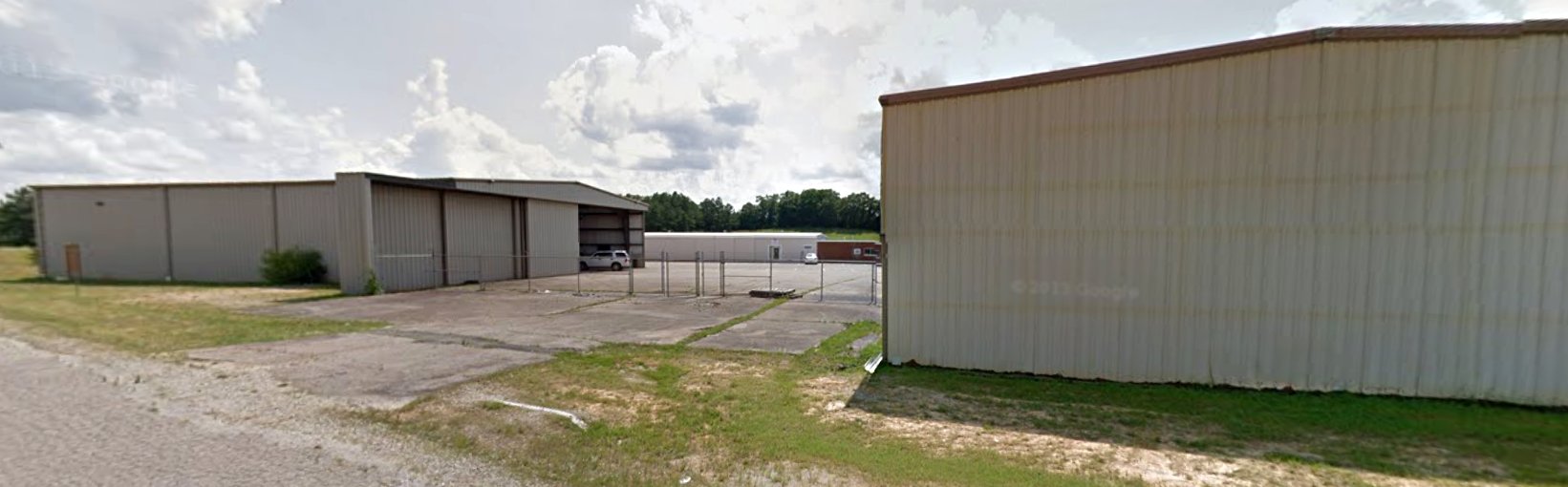
A 2023 photo looking west at the Nashville Police Airfield hangar & former runway.

A 2025 photo looking west along the Nashville Police Airfield runway, with a Eurocopter/Airbus helicopter visible in front of the hangar at left.
Jonathan Westerling reported, “Today the facility is still used for the helicopter fleet, and the runway still exists but is not used. It can be seen from Hartman Park which is at the eastern end of the runway.”

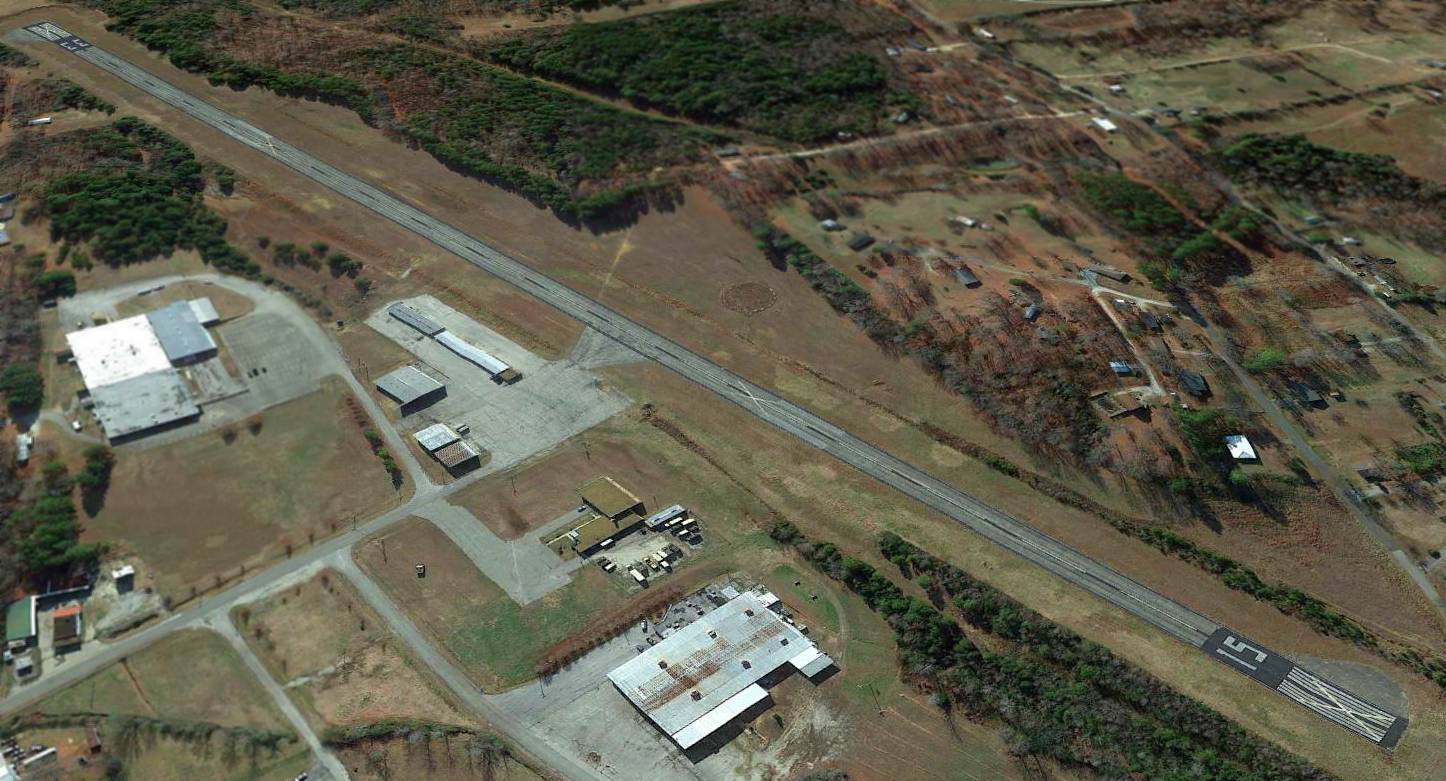
A 2025 aerial view looking northwest at the former Nashville Police Airfield, with helicopter markings visible in front of the hangar & on the former runway.
____________________________________________________
Camp Tyson, Paris, TN
36.24, -88.4 (West of Nashville, TN)
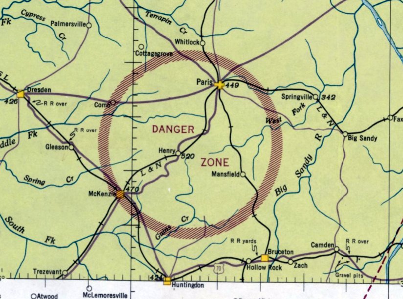
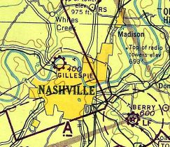
The March 1942 Nashville Sectional Chart depicted a circular Danger Zone around Camp Tyson.
Camp Tyson was not yet depicted on the September 1941 Nashville Sectional Chart.
According to the TN Encyclopedia, “Camp Tyson was the nation's only World War II barrage balloon training center.
Established at Paris, Henry County, the camp trained servicemen to fly, build, and repair barrage balloons,
which were helium- or hydrogen-filled balloons measuring 35' in diameter & 85' in length used in aerial coastal defense.
Made of a 2-ply cotton fabric impregnated by synthetic rubber & lofted 9,000-12,000' into the air,
the balloons were nicknamed 'big bags', 'air whales', and 'sky elephants'.
The massive quantities of rubber needed to construct the balloons drove up the cost of construction
to between $5,000-$10,000 apiece & became a factor in wartime rationing of rubber products & tires.”
The TN Encyclopedia continued, “The nearly invisible steel cables that anchored the small blimps posed the greatest danger to enemy aircraft.
Arranged in concentric circles, the cables provided a shield around important buildings, factories, or strategic areas.
The Nazi blitz on England and the Battle of Britain renewed the need for barrage balloons, which had proved effective in World War I antiaircraft protection.
Concerned about security of coastal cities, the U.S. War Department established the barrage balloon training center about 8 miles south of Paris, Tennessee, in August 1941.”
The TN Encyclopedia continued, “The 2,000-acre camp was named for Brigadier General Lawrence Tyson, a distinguished World War I veteran & prominent citizen of Knoxville.
Construction began in the early fall of 1941, and at its peak in December construction crews employed over 8,000 laborers
to erect 450 buildings including wooden barracks, a 400-bed hospital, and a 2,500-seat theater, all of which were served by a modern water system.
In March 1942 officers & enlisted men arrived in detachments of 5,000 or 6,000 men.
The March 1942 Nashville Sectional Chart did not depicted Camp Tyson itself,
but rather depicted a circular Danger Zone around the installation.
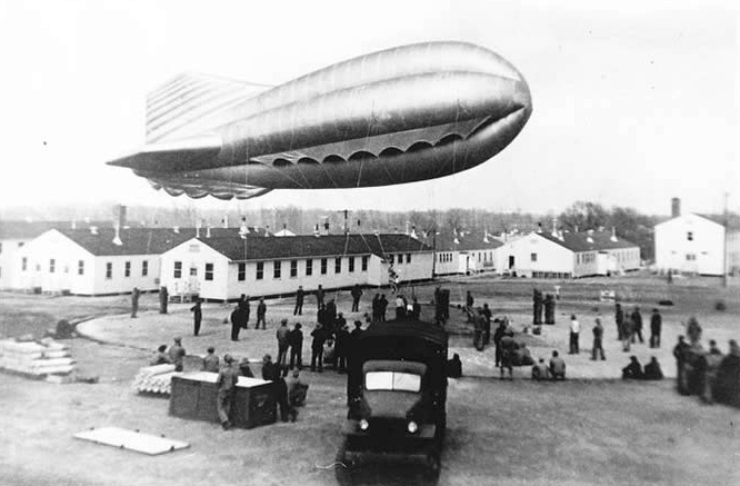
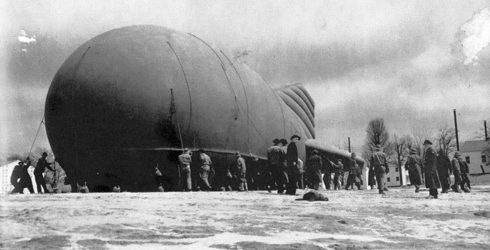
A circa 1942-45 photo of crews training with a barrage balloon at Camp Tyson.
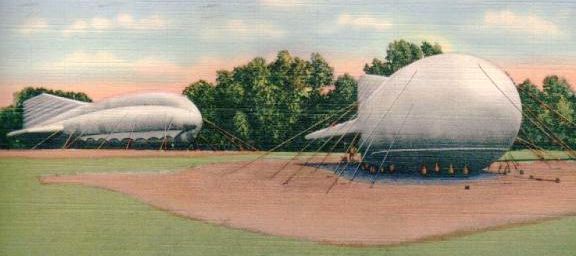
A colorized circa 1942-45 photo of 2 moored barrage balloons at Camp Tyson.
According to the TN Encyclopedia, “A 1943 expansion of the camp tripled the original 2,000 acres.
A well-known Henry County antebellum home, 'Bowdenville', was destroyed to accommodate the expansion.”
The TN Encyclopedia continued, “British instructors, who possessed firsthand knowledge of aerial bombing, helped to instruct Americans on proper balloon training.
Recruits learned how to quickly inflate & send balloons afloat & repair any punctures or damages the rubber skins received.
A good crew could fully inflate & launch a balloon in less than 30 minutes.
Like several other training camps in Tennessee, Camp Tyson also served as a Prisoner Of War camp for German & Italian POWs.
While at Camp Tyson, prisoners worked on the land & assisted in the development of area roads.”
An circa 1942-45 photo (courtesy of Robert Donovan) of a crew from the 306th Battalion training with a barrage balloons at Camp Tyson.
According to the TN Encyclopedia, “By the end of the war, Camp Tyson's occupancy ranged from 20,000-25,000 soldiers.
At the end of their training, balloon crews were billeted out for antiaircraft coastal duty.
They sent up balloons, assisted with antiaircraft guns, and manned the searchlights that crossed the skies.
As the world entered the nuclear age with the dropping of the atomic bomb, barrage balloons became an anachronism.
Although originally intended as a permanent military post, Camp Tyson closed after the war, and the H. C. Spinks Clay Company purchased the property.”
A 3/8/51 USGS aerial photo depicted the extensive street grid which remained at the site of Camp Tyson.
Although many buildings remained, apparently there was only one balloon hangar among them.
An 8/11/08 photo of the sole balloon hangar which remains at the site of Camp Tyson.
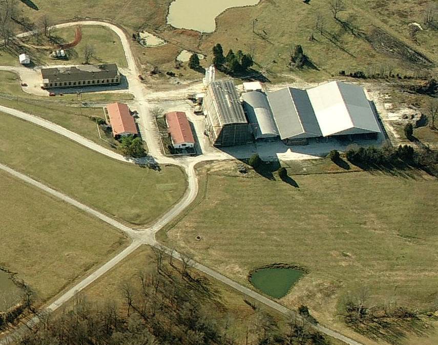
A circa 2010 aerial view looking south at the sole balloon hangar which remains at the site of Camp Tyson.
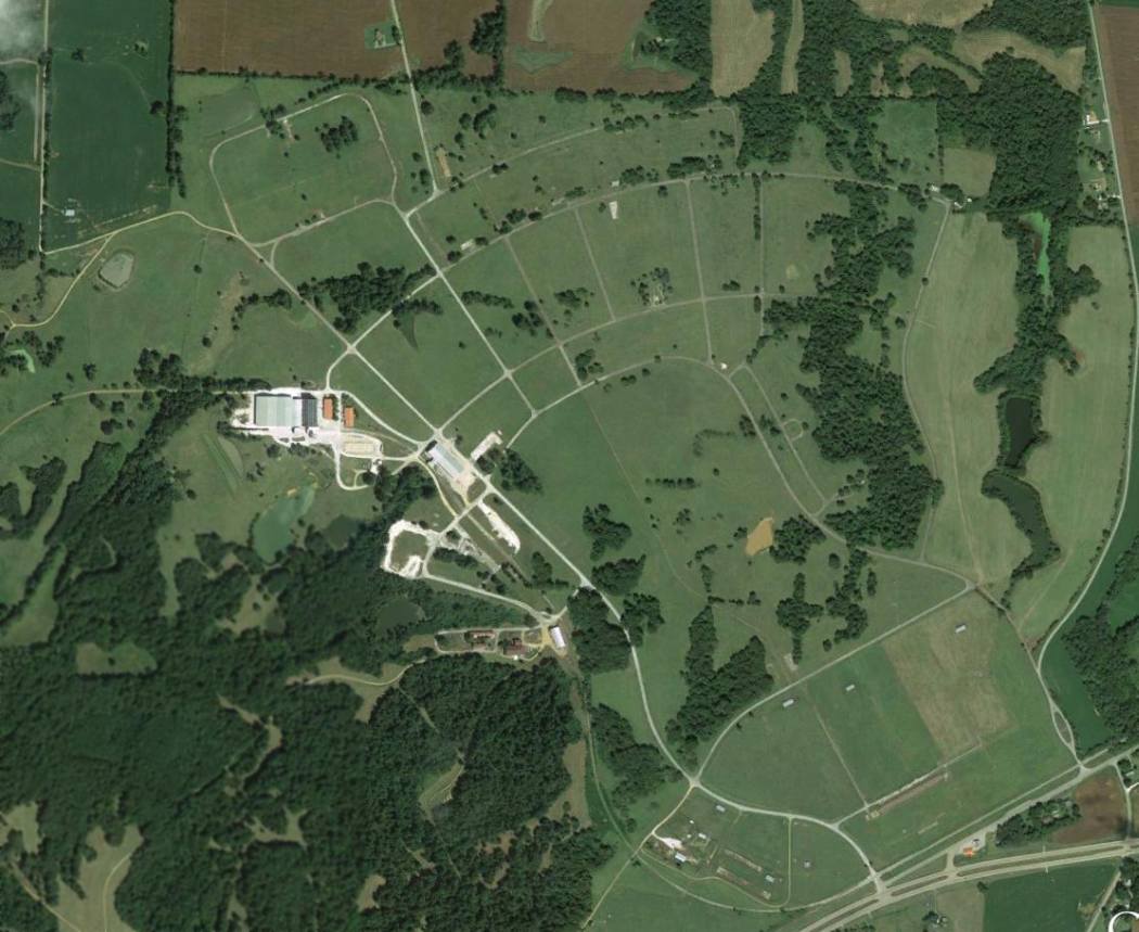
A 9/13/13 aerial view of the site of Camp Tyson.
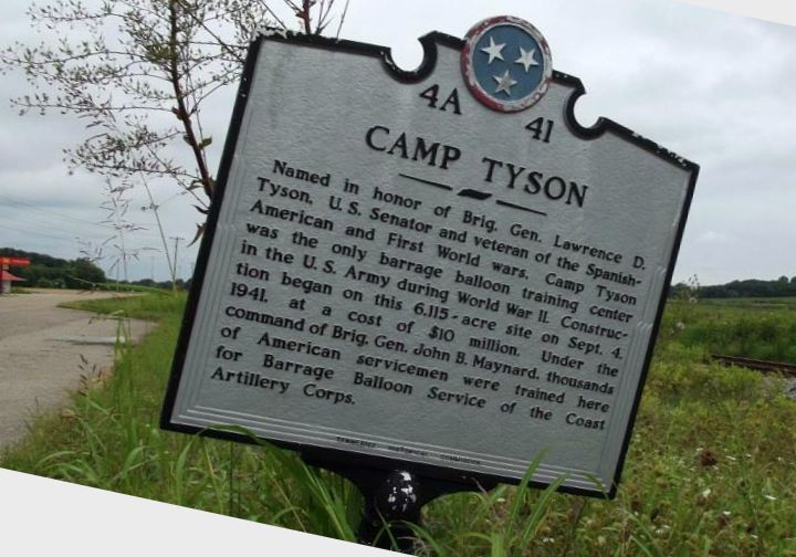
A 2014 photo by Robert Donovan of a historical marker at the site of Camp Tyson, which obviously has seen better days.
Robert reported, “Not much to see unless you like hayfields & cows.
The cement plant is pretty busy, a dozen or so dump trucks came in & out during the hour or so I was poking around.
Everything east of the cement plant at the old hangar is hayfield; cows have free range of the place.”

A 2014 photo by Robert Donovan of the sole balloon hangar which remains at the site of Camp Tyson.
The site of Camp Tyson is located northwest of the intersection of Route 79 & Carothers Road.
Thanks to Robert Donovan for pointing out this installation.
____________________________________________________
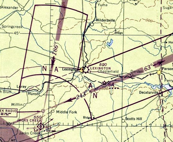
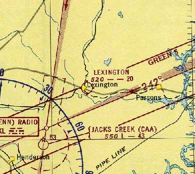
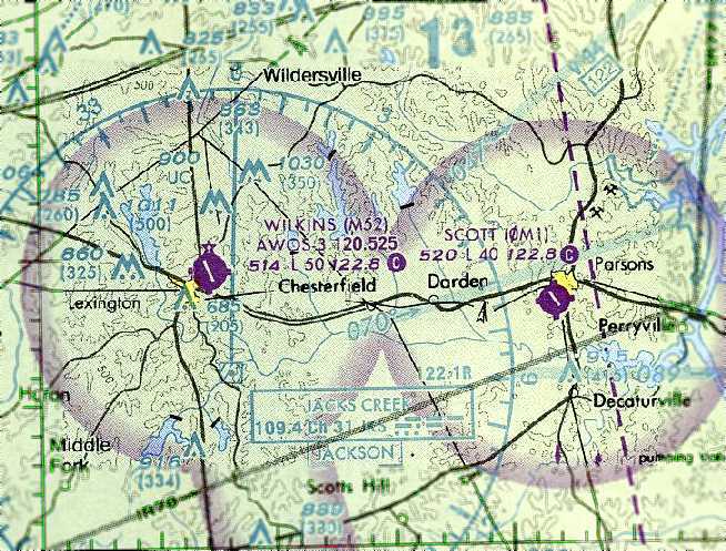
Lexington Airport / Franklin-Wilkins Airport, Lexington, TN
35.65, -88.38 (Southwest of Nashville, TN)
Lexington Airport, as depicted on the April 1947 Chattanooga Sectional Chart.
This general aviation airport was not yet depicted on the October 1946 Sectional Chart (according to Chris Kennedy).
According to a sign on the airport property, Lexington Airport was established in 1946.
The earliest depiction which has been located of Lexington Airport was on the April 1947 Chattanooga Sectional Chart.
It depicted Lexington Airport as a commercial/municipal airport.
According to the book “The Aviation History of Tennessee” by Jim Fulbright (courtesy of David Stevenson),
“The airport in Lexington was opened on 6/22/47.
Constructed with state & city funds, the field originally consisted of a 2,500' turf runway.”
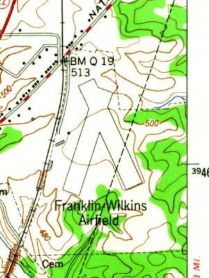
The earliest topo map depiction which has been located of Franklin-Wilkins Airport was on the 1950 USGS topo map.
It depicted the field as having 2 runways, with a few small buildings on the west side.
The February 1951 Boston Mountains World Aeronautical Chart (courtesy of Chris Kennedy) depicted Lexington Airport as having a 2,000' unpaved runway.
It was depicted as Franklin-Wilkins Airport on the August 1954 Chattanooga Sectional Chart (courtesy of Chris Kennedy).
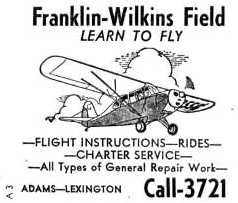
An undated (1950s?) advertisement for flight instruction at Franklin-Wilkins Field.
The Franklin-Wilkins runway was lengthened at some point between 1954-61,
as the January 1961 Chattanooga Sectional Chart (courtesy of Chris Kennedy)
depicted the field as having a 3,800' unpaved runway.
Tim Power recalled, “I grew up in Lexington & visited the Lexington Airport occasionally.
I remember in the 1960s a white haired Norwegian named Roald Boen was airport manager & taught flying out of there.
Mr Boen’s company was called Boen Aero.”
Jerry Anderson recalled, “Mr. Boen was my flight instructor.
I learned to fly at Lexington in the 1960s & flight instructed there for a while; in fact, I grew up at Franklin-Wilkins Field!
Mr. Boen once said that having the Jacks Creek VOR so close to Runway 15/33 made Franklin-Wilkins a very convenient refueling or rest stop for a lot of pilots.
Boen got to spend a half hour or so talking to no less than Paul Harvey.”
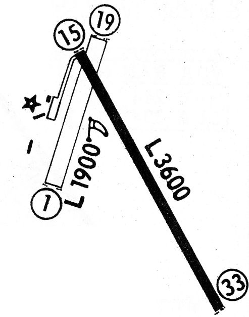
Franklin-Wilkins Airport evidently gained a paved runway at some point between 1961-68,
as the 1968 Flight Guide (courtesy of Robert Levittan) depicted the field as having a single paved 3,600' Runway 15/33,
along with an unpaved 1,900' Runway 1/19. A taxiway leading to a ramp with a few small buildings were depicted along the northwest side.
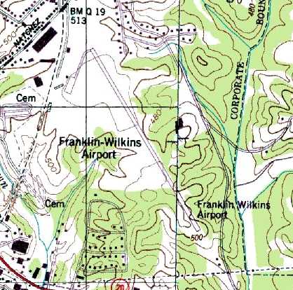
The 1985 USGS topo map depicted Franklin-Wilkins Airport as having a single paved northwest/southeast runway,
with a taxiway leading to a ramp with a few small buildings along the northwest side.
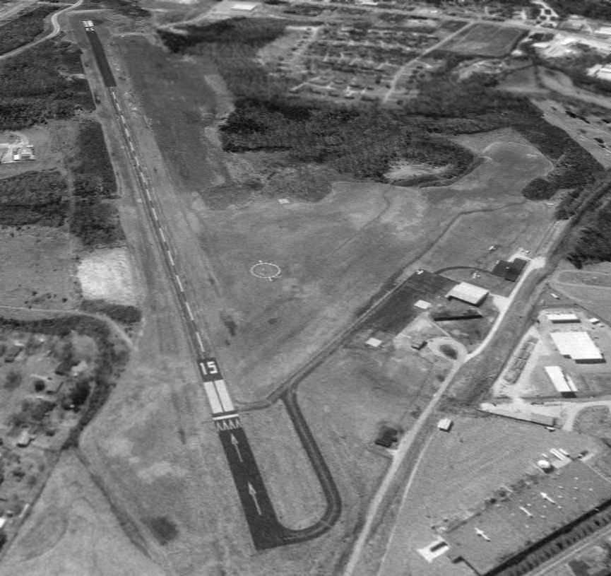
The earliest photo which has been located of Franklin-Wilkins Airport was a 2/23/97 USGS aerial view looking south.
It depicted the field as having a single paved Runway 15/33, with a taxiway leading to a ramp with a few small buildings along the northwest side.
Three single-engine aircraft were visible on & around the ramp.
The last aeronautical chart depiction which has been located of Franklin-Wilkins Airport
was on the April 2004 Memphis Sectional Chart (courtesy of Chris Kennedy).
It depicted the field as having a single paved 5,000' runway.
A larger Beech River Regional Airport opened in 2006 a few miles to the east.
Franklin-Wilkins Airport was closed on 7/1/06, according to Mike Key.
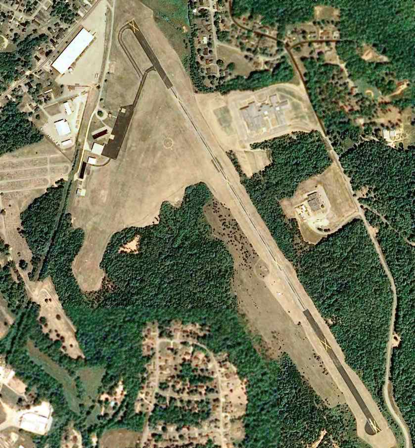
A 6/6/07 USDA aerial photo showed that closed-runway “X” markings had been painted along the Franklin-Wilkins Airport runway.
The airport otherwise remained completely intact.
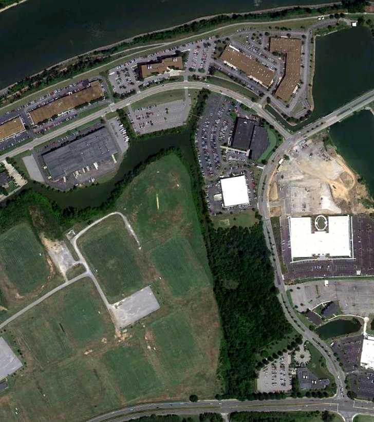
A 2010 aerial photo shows that 4 soccer fields were built adjacent to the west side of the runway, which otherwise remained intact.
The ramp was reused as a parking lot for the athletic fields.
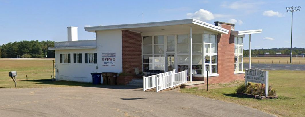
A 2023 photo looking east at the former Franklin-Wilkins Airport office, reused as a VFW post.
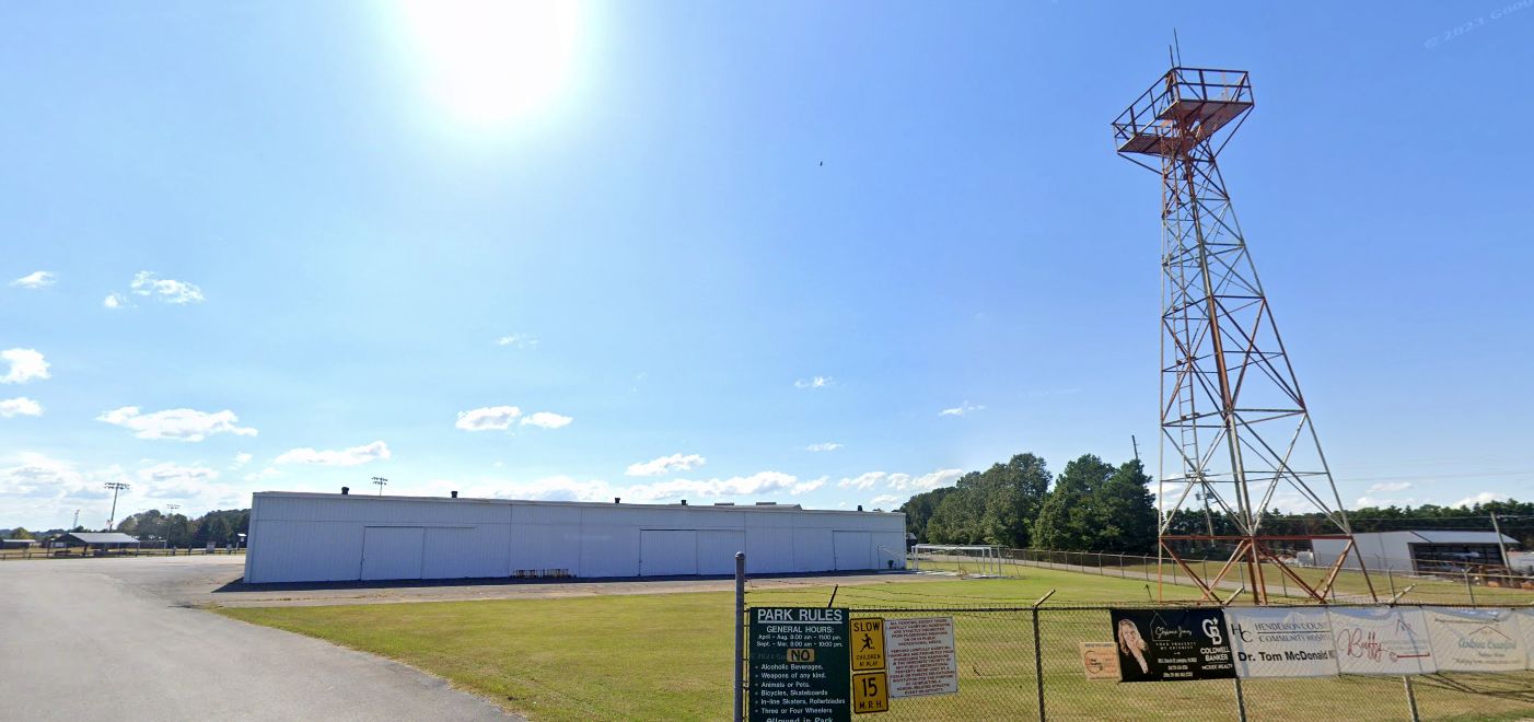
A 2023 photo looking south at a former Franklin-Wilkins Airport hangar & beacon light tower.
The site of Franklin-Wilkins Airport is located south of the intersection of Natchez Trace Drive & Airport Road, appropriately enough.
Thanks to Chris Kennedy for pointing out this airfield.
____________________________________________________
McConnell Field, Nashville, TN
36.14, -86.844 (West of Downtown Nashville, TN)
An undated aerial view of McConnell Field from a 4/12/31 article.
According to an article in the 12/21/03 issue of The Tennessean (courtesy of Marvin Maes),
the poor condition of the unpaved roads leading to Blackwood Field (and the cost of improving them)
removed the earlier Blackwood Field from contention for serving as a permanent airmail airfield for Nashville.
The increasing use of airmail also brought about the need for a closer airport to Nashville,
eventually leading to the establishment of McConnell Field (west of downtown Nashville) in 1927.
The 105th Observation Squadron relocated from Blackwood Field to McConnell Field in 1927.
The earliest depiction which has been located of McConnell Field was a undated aerial view from a 4/12/31 article,
which depicted 2 hangars alongside a grass airfield.
A 7/12/31 aerial view looking north at McConnell Field
depicted several biplanes & a line of spectators in front of 2 hangars on the east side of a grass airfield.
A closeup from the 7/12/31 aerial view showing biplanes, spectators, and the hangars of McConnell Field.
The Commerce Department's 10/12/31 Airway Bulletin depicted McConnell Field as having 3 unpaved runways,
with the longest being the 2,000' northeast/southwest & northwest/southeast strips.
A single building with a windsock was depicted on the southeast corner.
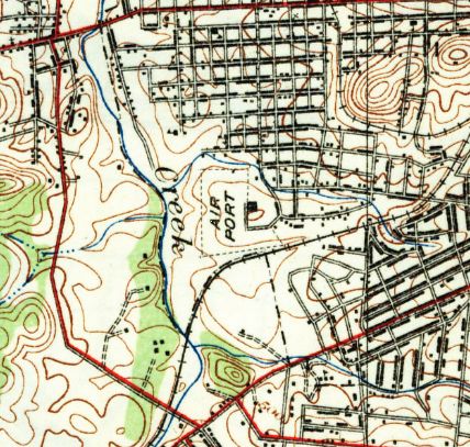
The earliest topo map depiction which has been located of McConnell Field was on the 1932 USGS topo map.
It depicted an L-shaped property outline, labeled simply as “Air Port”, with a single building on the east side.
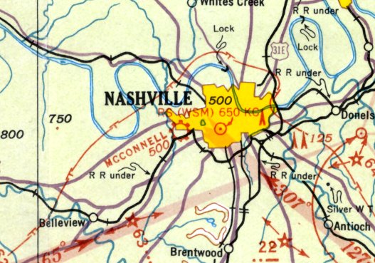
The only aeronautical chart depiction which has been located of McConnell Field was on the September 1935 Nashville Sectional Chart.
It depicted McConnell as a commercial/municipal airport.
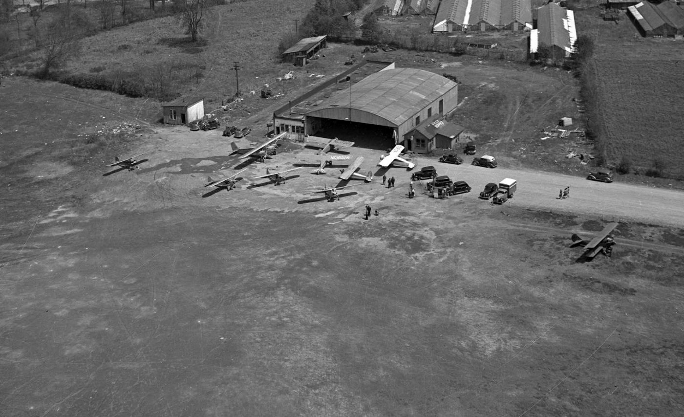
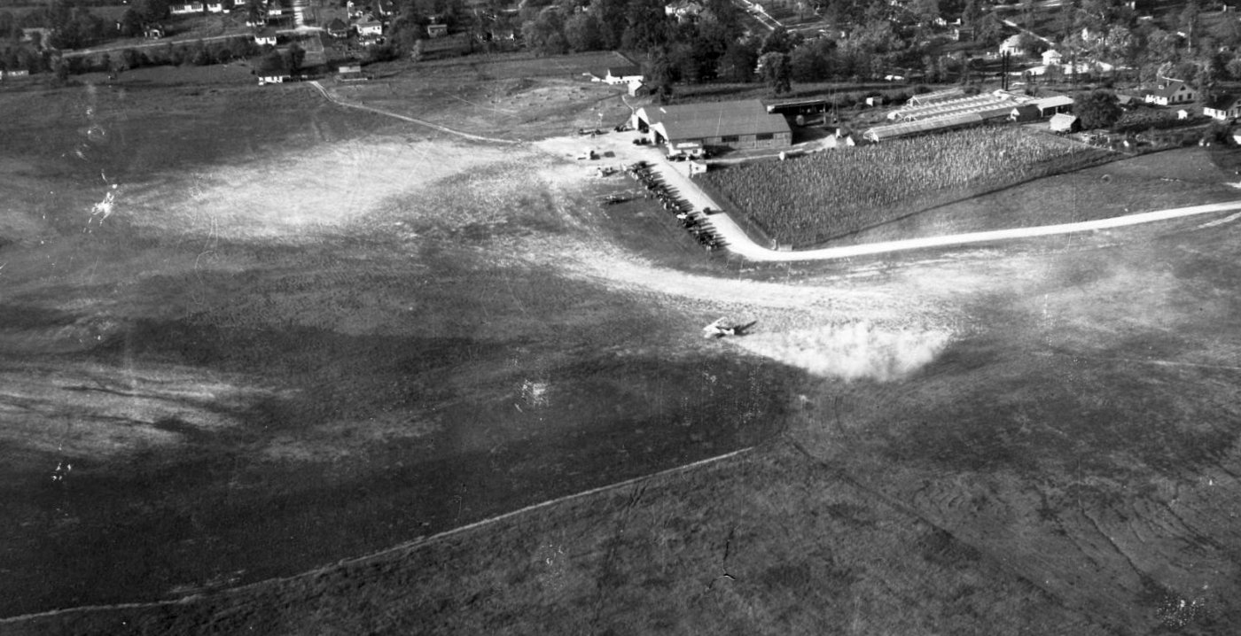
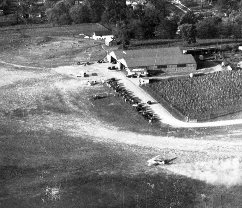
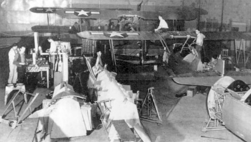
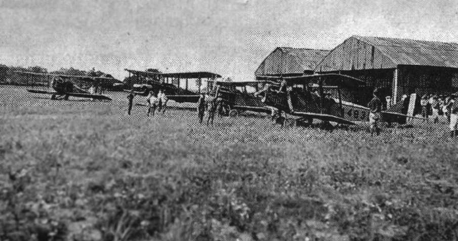
A 1938 aerial view looking east showing 10 monoplanes & biplanes in front of a single hangar at McConnell Field.
The second hangar visible in the previous photo had evidently been removed at some point between 1931-38.
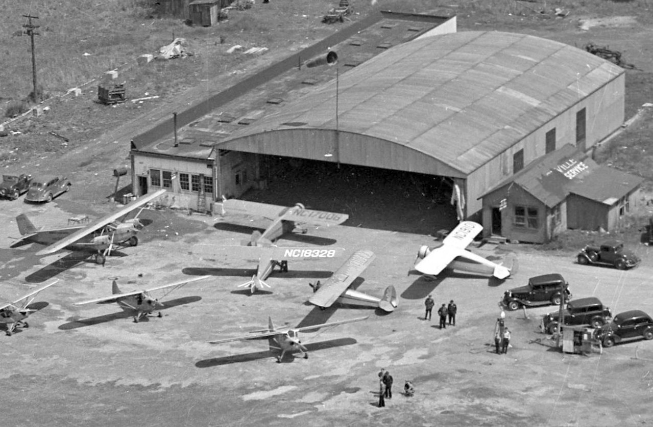
A closeup from the 1938 aerial view showing an arrangement of monoplanes & biplanes in front of the McConnell Field hangar.
The office to the right was marked “Ville Service”.
The 1943 USGS topo map continued to depict the McConnell “Air Port” in the same manner as the 1932 topo map.
The date of closure of McConnell Field has not been determined.
The 1954 USGS topo map depicted the “McCabe Park Golf Course” covering the site of McConnell Field.
An article in the 8/26/68 Tennessean described how a realtor had agreed to pay $60,000 for the 67 acre McConnell Field property,
with the understanding that several acres would be deeded to the city for school construction.
A 1992 aerial photo showed no trace of McConnell Field, with the property having become the McCabe Golf Course.
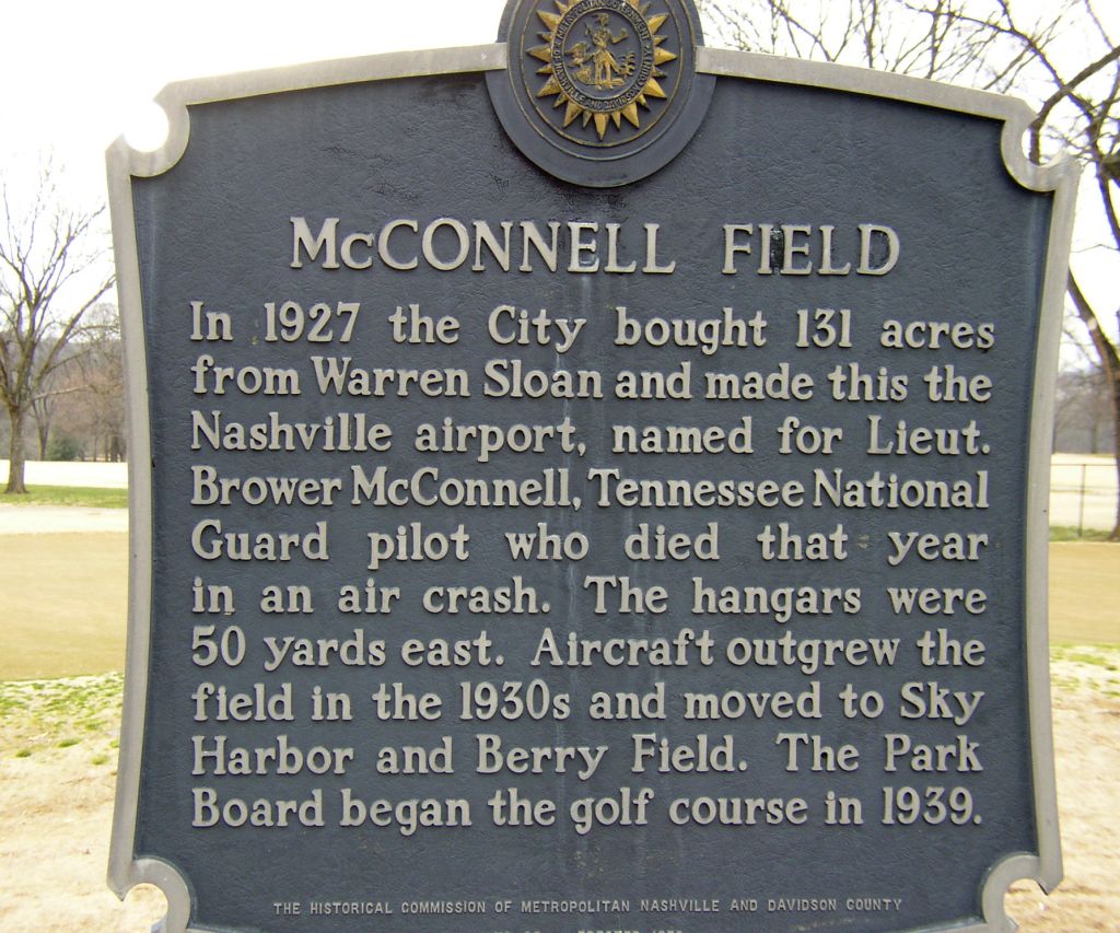
A 2007 photo by John Bailey of a historical marker at the site of McConnell Field.
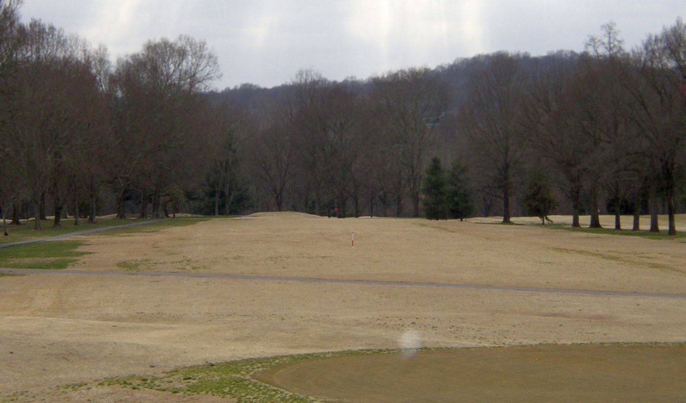
A 2007 photo by John Bailey looking south at the site of McConnell Field, now the McCabe Golf Course.
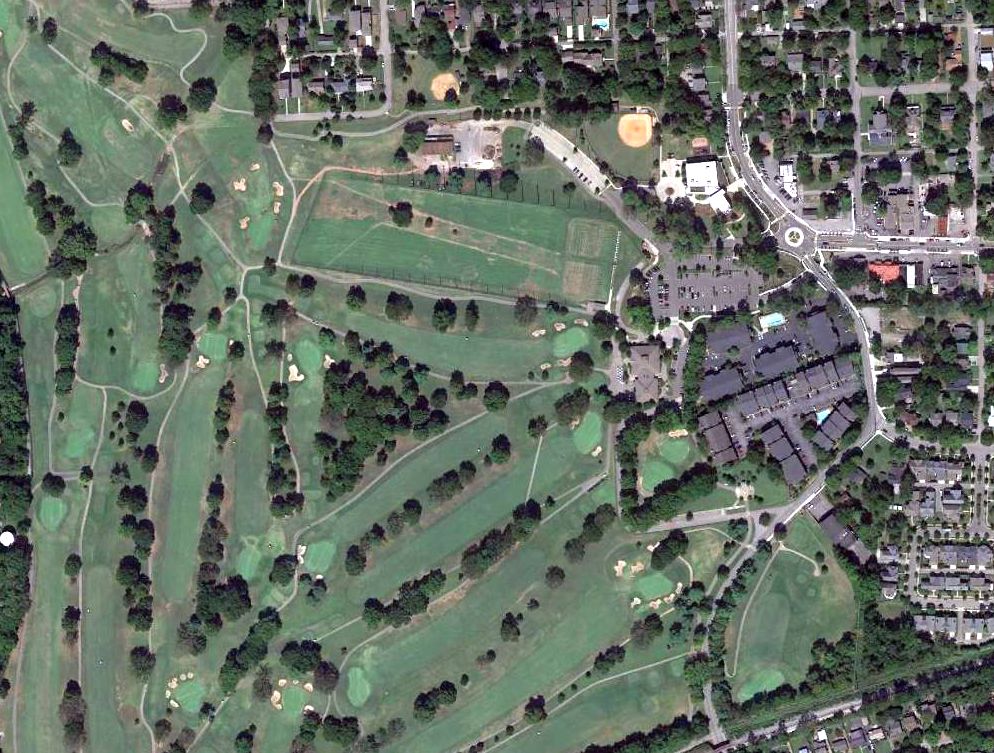
A 2015 aerial view of the site of McConnell Field, now the McCabe Golf Course.
The site of McConnell Field is located northwest of the western terminus of Murphy Road.
__________________________________________________
Fort Campbell Sky Drop Army Airfield, Big Rock, TN
36.63, -87.71 (Northwest of Nashville, TN)
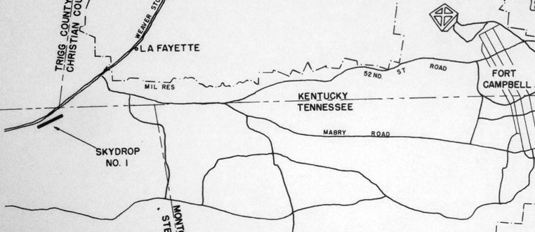
A circa 1954 map of the “Skydrop #1” airfield, showing its location relative to Fort Campbell (from the St. Louis National Personnel Records Center, courtesy of Ron Plante).
Ron Plante reported, “In late 1953, the Air Force & Army started a test called Operation Sky Drop
where Fort Bragg Army engineers built a dirt strip using equipment capable of being dropped by parachute.
A site was selected on the Fort Campbell reservation about 10 miles southwest of what was then Campbell AFB.
Once built, this strip was suitable for USAF C-119, C122, and C-124 cargo planes.
Construction work was completed in the spring of 1954.”
No airfield was depicted at this location on the 1954 or 1955 Nashville Sectional Charts.
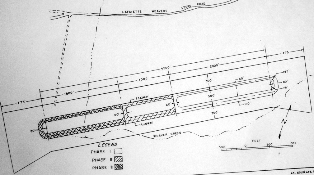
A circa 1954 map showing the 3 phases of construction of the Sky Drop airfield (from the St. Louis National Personnel Records Center, courtesy of Ron Plante),
consisting of a east/west runway with parallel taxiway, of progressively longer lengths.
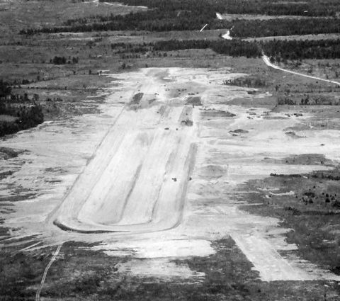
A circa 1954 aerial view looking west at the Sky Drop airfield (from the St. Louis National Personnel Records Center, courtesy of Ron Plante),
showing an east/west unpaved runway with a parallel taxiway.

A circa 1954 photo of the takeoff of a rare Chase C-122 Avitruc from the Sky Drop airfield (from the St. Louis National Personnel Records Center, courtesy of Ron Plante).
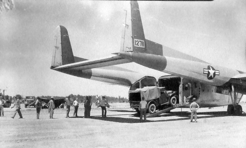
A circa 1954 photo of a truck being unloaded from the rear ramp of a twin-boom Fairchild C-119 Flying Boxcar
on the Sky Drop airfield (from the St. Louis National Personnel Records Center, courtesy of Ron Plante).
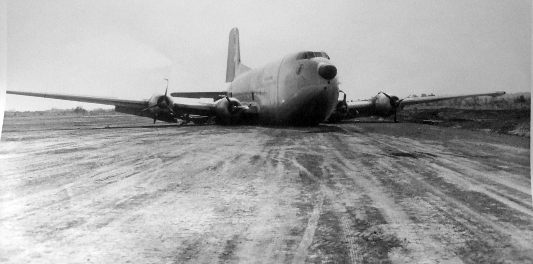
A photo showing the aftermath of the bad landing on 6/27/54 of the 1st Douglas C-124C Globemaster II (51-5210 from Donaldson AFB's 52nd TCS)
at the Sky Drop airfield (from the St. Louis National Personnel Records Center, courtesy of Ron Plante).
Ron Plante reported, “the main gear struck a 12’ dirt fill embankment just short of the approach end.
The main gear detached from the aircraft, and the nose gear was rammed into the cargo compartment. No crew were injured.”
According to Mark Morgan, after the Sky Drop C-124 accident, the “aircraft was classified damaged beyond repair & apparently scrapped on site.”
After the 1954 C-124C accident, Ron Plante reported, “It is unknown if any further flight testing took place at this site.”
A 1955 aerial photo showed the Sky Drop runway & taxiway,
and what appears to be an large aircraft fuselage with a partial wing (possibly the accident C-124 which was scrapped on-site) on a paved square pad on the northeast side.

The 1957 USGS topo map depicted the Sky Drop Airfield as an east/west runway, with a parallel taxiway, labeled simply as “Airfield”.
A 10/19/73 USGS aerial photo showed the outline of the Sky Drop Airfield to remain recognizable though deteriorated,
along with a concrete ramp or foundation on the north side of the runway.
A 2013 aerial view looking southwest still showed the outline of the Sky Drop Airfield to remain recognizable,
along with possibly a concrete foundation on the north side of the runway.
The site of Fort Campbell Sky Drop Army Airfield is located southwest of the intersection of Artillery Road & Angels Road.
Thanks to Ron Plante for pointing out this airfield.
____________________________________________________
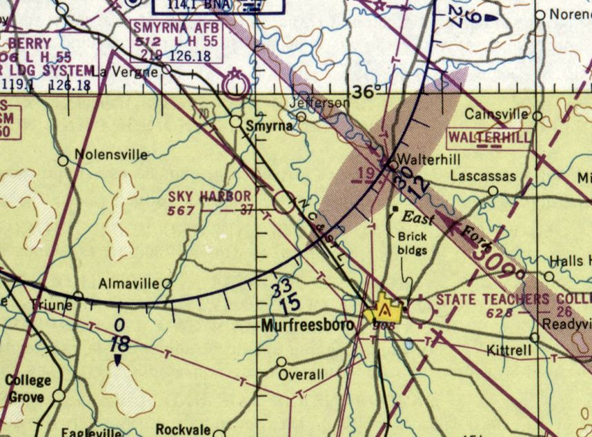
State Teachers College Airport, Murfreesboro, TN
35.848, -86.368 (Southeast of Nashville, TN)

State Teachers College Airport, as depicted on the March 1944 Chattanooga Sectional Chart.
No airfield was yet depicted at this location on the 1941 USGS topo map or the August 1942 Chattanooga Sectional Chart.
According to the book “The Aviation History of Tennessee” by Jim Fulbright (courtesy of David Stevenson),
“In the Spring of 1943, Middle Tennessee State College was chosen by the Army's Flight Training Command
as the site for the 11th College Training Detachment.
State College Airport was constructed on a few acres of the campus now occupied by Forrest Hall.
A training contract went to a Nashville firm known as the Murfreesboro Flying School & later, Murfreesboro Flying Service.”
The earliest depiction which has been located of State Teachers College Airport was on the March 1944 Chattanooga Sectional Chart,
which depicted it as a commercial/municipal airport.
According to the book “The Aviation History of Tennessee” by Jim Fulbright (courtesy of David Stevenson),
“In 1946 the college formed an aviation club consisting of students from the training detachment, as well as those planning an aviation career.
In 1948 the college organized a Civil Air Patrol squadron which was supervised by Major Elmour Merriwether & Captain Miller Lanier.”
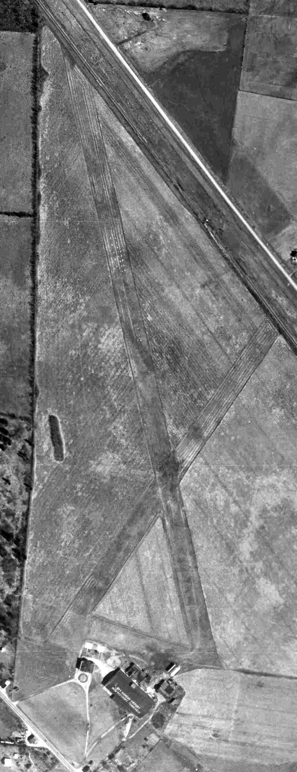
The earliest photo which has been located of State Teachers College Airport was a 2/23/50 USGS aerial view.
It depicted 3 light single-engine aircraft parked on the west side of a north/south grass runway.
The last aeronautical chart depiction which has been located of the State Teachers College Airport was on the February 1950 Chattanooga Sectional Chart,
which depicted State Teachers College Airport as having a 2,600' unpaved runway.
A circa 1950s photo of the State Teachers College Airport hangar (courtesy of Curtis Parish).
A 1952 photo of 2 Aeronca L-19s during Civil Air Patrol maneuvers at the State Teachers College Airport.
According to the book “The Aviation History of Tennessee” by Jim Fulbright (courtesy of David Stevenson),
“In 1952 a new airport for Murfreesboro was established.
Both MTSU & public aviation operations moved to the site.”
A map from the 1952 Middle Tennessee State University yearbook labeled the former State Teachers College Airport hangar as the “ROTC Armory”.
The February 1955 Chattanooga Sectional Chart no longer depicted State Teachers College Airport,
but instead depicted the new Murfeesboro Airport to the northwest.
The 1957 USGS topo map no longer depicted the State Teachers College Airport.
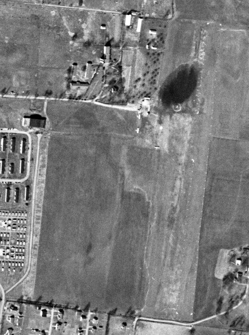
A 3/29/59 USGS aerial view (courtesy of Dick Merrill) depicted the State Teachers College Airport after its closure.
The hangar remained on the west side, and the north/south grass runway remained intact on the east side,
but there was no sign of any recent aviation usage.
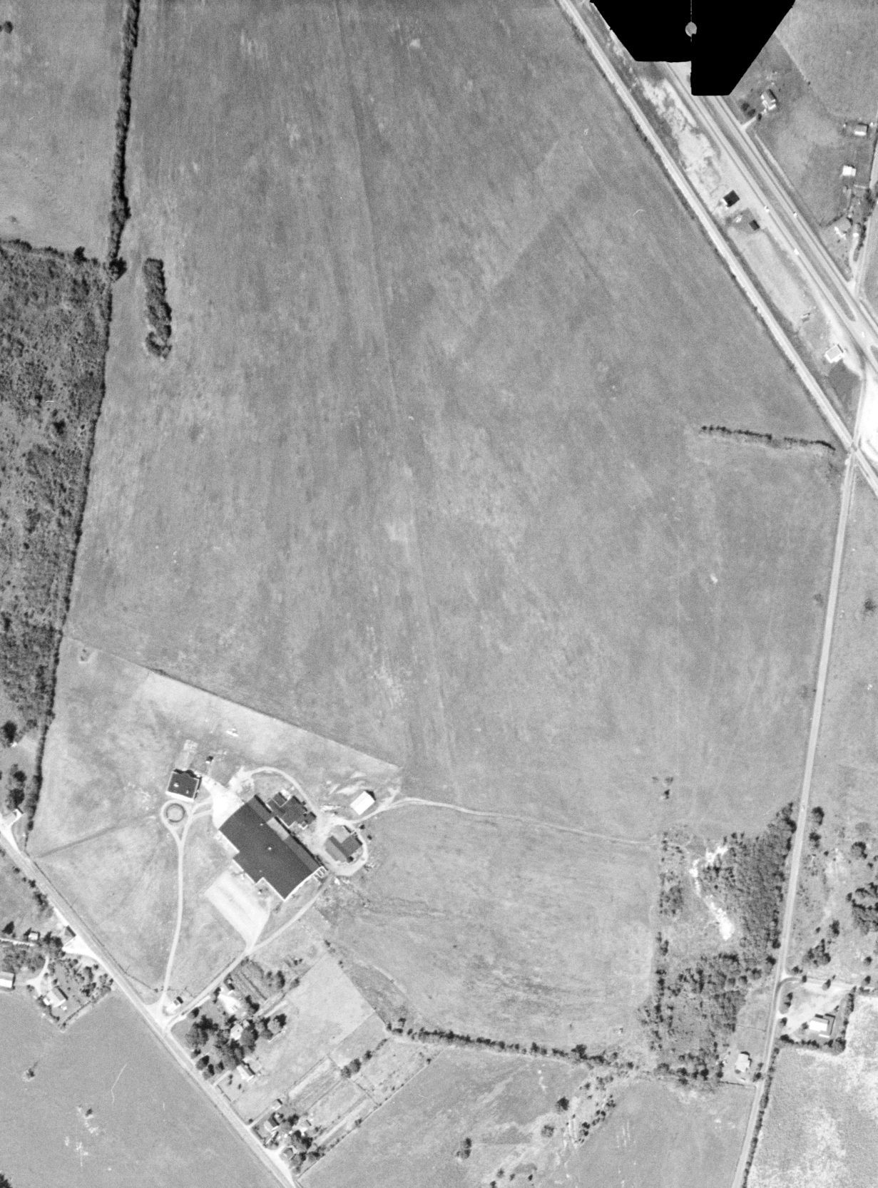
An 8/1/11 aerial photo showed many buildings of Middle Tennessee State University covering the site of the State Teachers College Airport,
with the former hangar near the top-left.
A 2/10/14 photo by Curtis Parish of the former hangar which remains at the site of the State Teachers College Airport.
Curtis reported, “The ROTC program at MTSU uses it. Part of it is used for an indoor electronic rifle range.”
The site of State Teachers College Airport is located at the intersection of Champion Way & Military Memorial.
Thanks to Curtis Parish for pointing out this airfield.
____________________________________________________
Tennessee's Sky Harbor Airport, Murfreesboro, TN
35.923, -86.473 (Southeast of Nashville, TN)
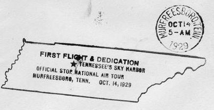
A postmark commemorating the 10/14/29 dedication of Sky Harbor Airport.
According to the book “The Aviation History of Tennessee” by Jim Fulbright (courtesy of David Stevenson),
“Early in 1929 residents of Rutherford County learned that a large airline planned to open an airfield in the area.
On 3/22/29, Interstate Airlines Inc. bought 152 acres of land on what had been the Martha Crostwaite Farm,
seven miles north of Murfreesboro on the Old Dixie Highway.
Construction of the airfield began on June 5,
and the official dedication of Sky Harbor Airport was held 10/14/29.
Jimmy Doolittle, air racer & famous research pilot who literally invented instrument flight,
performed in the dedication ceremonies.”
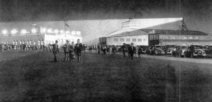
A circa 1929-37 artist's depiction of a nighttime event at Sky Harbor Airport.
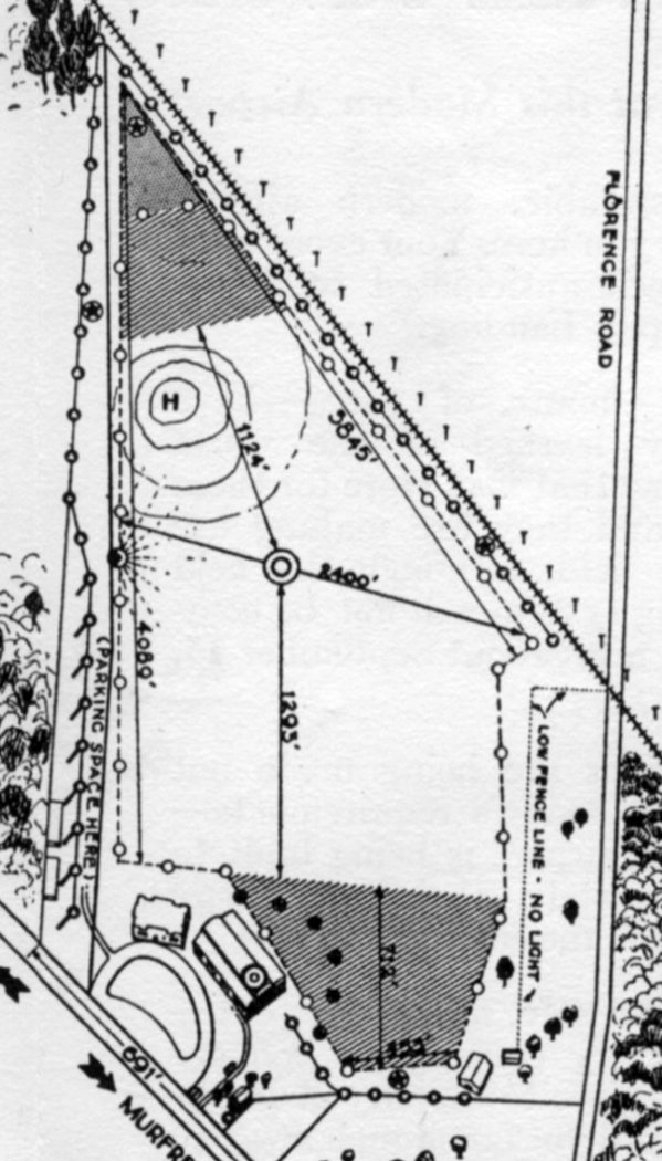
A circa 1929 plan of Sky Harbor, from an Interstate Airlines brochure promoting the field (courtesy of Tom Heitzman).
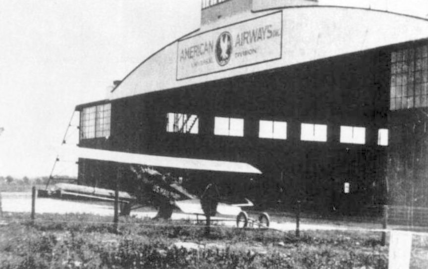
A circa 1930s photo of a U.S. Mail biplane (type unknown) in front of an American Airways hangar st Sky Harbor.
In 1930 the 105th Observation Squadron used Sky Harbor on a temporary basis for a few months,
but its distance from Nashville made it a less desirable National Guard post.
On 11/25/30, the 105th Observation Squadron was disbanded & the aircraft & equipment were moved to Memphis Municipal Airport,
a move made necessary in order to comply with the requirement by the Militia Bureau for National Guard air units to operate from an A-1 airport.
A circa 1930s photo of Sky Harbor's terminal building & main hangar.
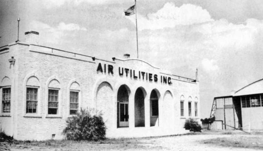
A circa 1930s photo of Sky Harbor's whitewashed terminal building, marked “Air Utilities Inc.”
Weather instruments such as barometers were mounted on the corners of the roof.
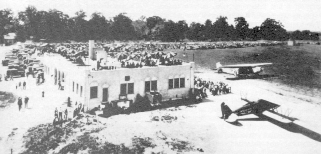
A circa 1930s photo of a large crowd gathered at Sky Harbor, with a Fokker TriMotor & an Airmail biplane (type unidentified) on the field.
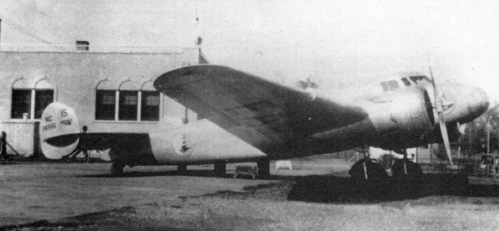
A 1935 photo of an Eastern Air Lines Lockheed 10B at Sky Harbor.
Eastern operated the aircraft on its Chicago to Miami route, and this particular 10B was the 4th example delivered to Eastern.
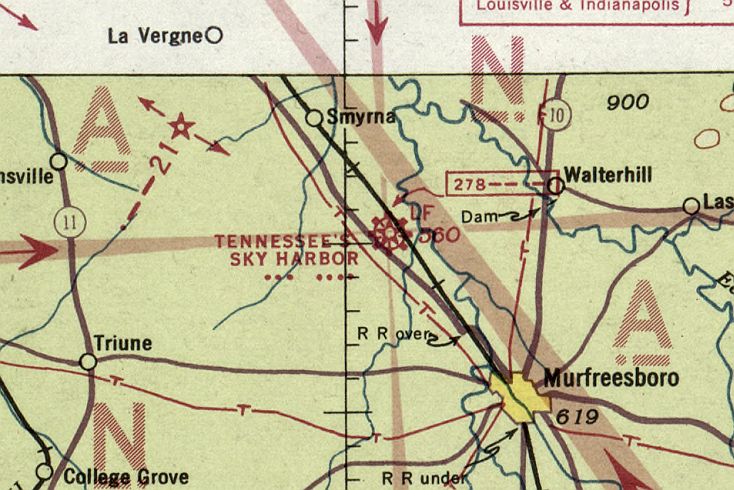
The earliest aeronautical chart depiction which has been located of Sky Harbor was on the January 1936 Chattanooga Sectional Chart.
It depicted “Tennessee's Sky Harbor” as a commercial/municipal airport.
The 1941 USGS topo map didn't depict Sky Harbor Airport,
just a few small buildings along its southwest side.
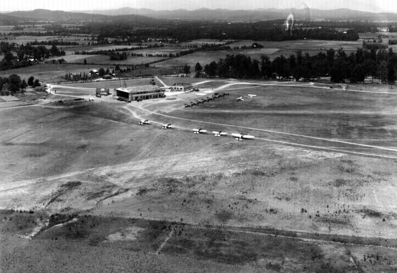
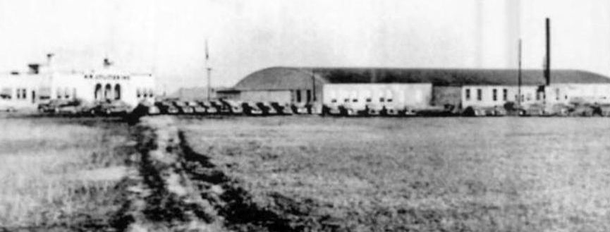
A June 1941 aerial view looking southwest at Sky Harbor hangar, showing the hangar & terminal, and over a dozen military aircraft on the field.
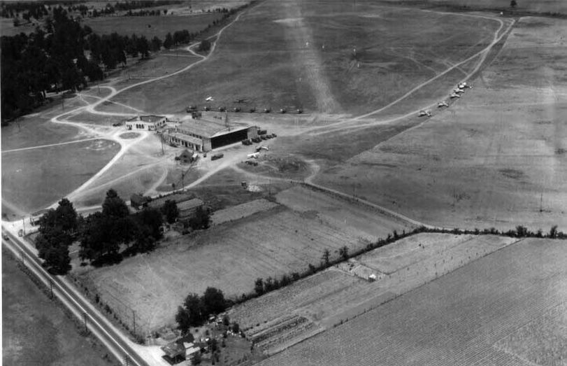
A June 1941 aerial view looking northwest at Sky Harbor hangar, showing the hangar & terminal, and over a dozen military aircraft on the field.
A circa 1940s photo of what appear to be Army Stearman biplanes under maintenance inside a Sky Harbor hangar.
Sky Harbor Airport may have gone through a period of closure during WW2 (like many other small civilian airports),
as it was not depicted on the March 1944 Nashville Sectional Chart (courtesy of Thomas Ramsey).
According to the book “The Aviation History of Tennessee” by Jim Fulbright (courtesy of David Stevenson),
“During WW2 Sky Harbor was purchased by Air Utilities Inc. for its plane repair plant.
Later it became Alfred Hoffman's bomb factory, where practice bombs were made.”
The last aeronautical chart depiction which has been located of Sky Harbor was on the February 1950 Chattanooga Sectional Chart.
It depicted Sky Harbor as having a 3,700' unpaved runway.
Sky Harbor Airport may have been closed by 1950, as the 1950 USGS topo map didn't label the airport,
but the terminal building & hangar were still depicted.
A 3/22/51 USGS aerial view showed Sky Harbor perhaps after its closure.
The field had 2 grass runways, the terminal building, and the main hangar's roof was painted with “Sky Harbor Airport, Murfreesboro Tennessee”.
But no aircraft were visible on the field.
Sky Harbor Airport was no longer depicted on the February 1954 Chattanooga Sectional Chart.
The last photo which has been located of Sky Harbor Airport was a 10/5/58 USGS aerial view (courtesy of Dick Merrill).
The field was still intact, with the runways still recognizable but less distinct compared to the 1951 photo.
The terminal building remained, along with the main hangar, but the “Sky Harbor Airport, Murfreesboro Tennessee” lettering on its roof had been removed at some point between 1951-58.
However, 1 light single-engine aircraft was visible parked just north of the hangar, so the airport might have continued to see some use even after its official closure.
The 1972 USGS topo map continued to depict Sky Harbor's terminal building & hangar.
The 1977 USGS topo map continued to depict Sky Harbor's hangar,
but the terminal building had been removed & a new street had been built over it.
According to the 1996 book “The Aviation History of Tennessee” by Jim Fulbright (courtesy of David Stevenson),
“Today the old terminal area is the site of a boat manufacturing plant, and the airfield has returned to agricultural use.”
A 1997 USGS aerial photo showed the former Sky Harbor hangar had been expanded into a larger industrial building.
The 1999 USGS topo map continued to depict Sky Harbor's hangar.
An 8/1/11 aerial photo showed houses covering the northern portion of the Sky Harbor site.
The former Sky Harbor hangar had been expanded into a larger industrial building.
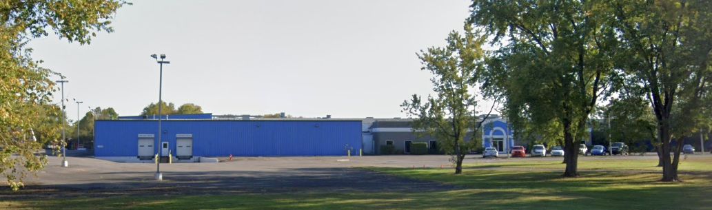
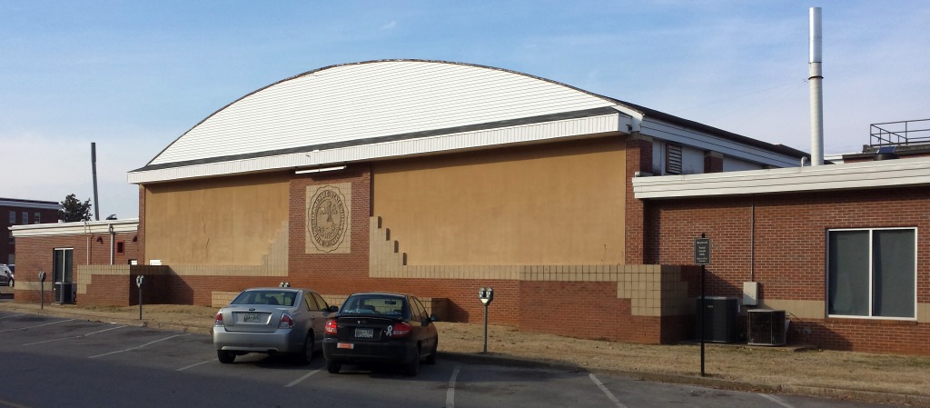
A 2023 photo looking northeast at the Better Metal industrial building which was built around the former Sky Harbor hangar.
An article in the 7/18/13 issue of The Tennessean (courtesy of Curt Parish) described how a drive-in movie theater was being proposed for the site of Sky Harbor Airport.
The site of Sky Harbor Airport is located northwest of the intersection of Old Nashville Highway & Florence Road.
____________________________________________________
Gillespie Field / Cumberland Airport, Nashville, TN
36.2, -86.813 (Northwest of Downtown Nashville, TN)
Gillespie Field, as depicted on the March 1944 Nashville Sectional Chart (courtesy of Thomas Ramsey).
According to the book “The Aviation History of Tennessee” by Jim Fulbright (courtesy of David Stevenson),
“Gillespie Field was developed in 1941 by Nashville entrepreneur & pilot Jim Gillespie.
His idea was to give private & commercial aviation a new home
at a time when military activity was taking over virtually all of Berry Field.
Gillespie purchased property north of downtown, along the river, and began a flying school.
The airport consisted of a a northeast/southwest turf runway.
The total usable length was 3,300' which included a 1,500' paved portion on the northeast end
where the hangars & offices were located.”
According to Wikipedia, “During World War II, it was leased to the United States Army Air Forces as a training airfield.”
From 10/3/42-11/2/42 the following Known USAAF units trained at Gillespie Field:
the 305th, 306th, 307th, and 308th Dive Bombardment Squadrons.
The earliest depiction which has been located of Gillespie Field
was on the March 1944 Nashville Sectional Chart (courtesy of Thomas Ramsey).
According to Wikipedia, “Returned after the war to private ownership,
it was later bought by the city of Nashville & was renamed 'Cumberland Field'.”
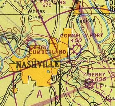
The October 1946 Nashville Sectional Chart (courtesy of Jim Stanton)
depicted Cumberland Airport as a commercial/municipal airport.
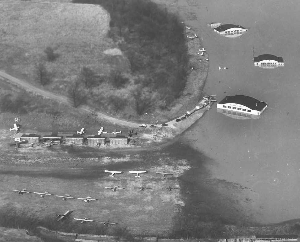
The earliest photo which has been located of Cumberland Airport
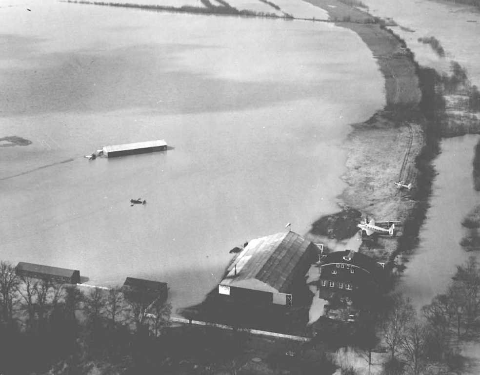
was a sad 2/14/48 aerial view looking southwest during a flood.
It showed 2 aircraft remaining above water near the 2 hangars, but 3 smaller aircraft partially submerged on the middle of the field.
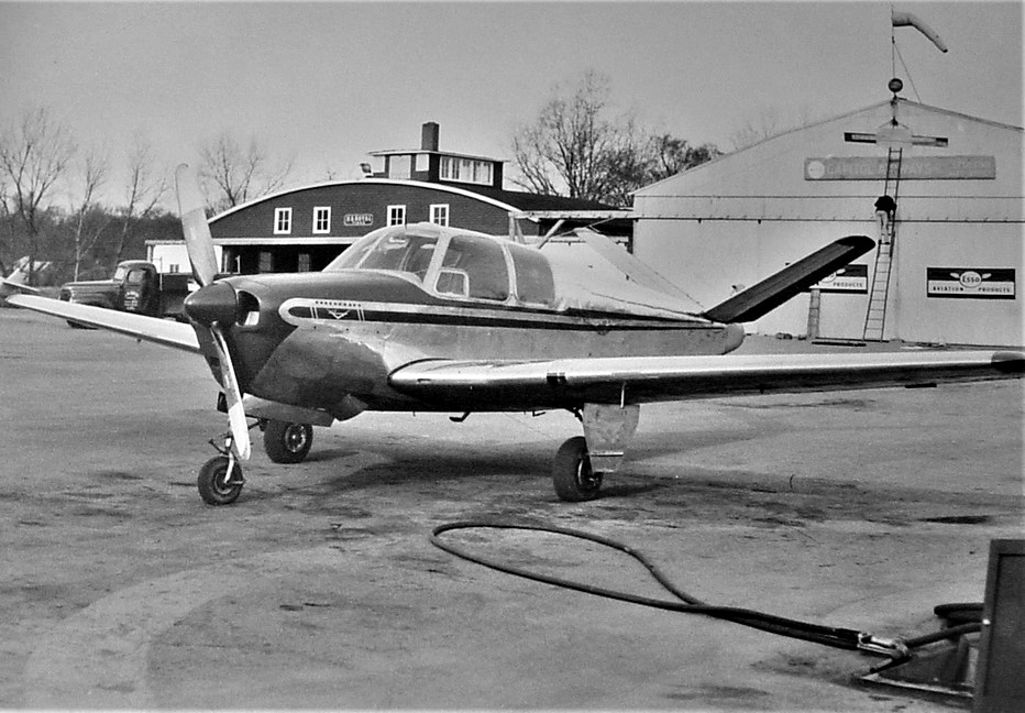
A circa 1950 photo by Russell Eberhardt (courtesy of William Eberhardt) of a Beech Bonanza in front of the Gillespie Field Capitol Airways hangar.
A circa 1950 photo by Russell Eberhardt (courtesy of William Eberhardt) of a Stinson in front of the Gillespie Field Capitol Airways hangar.
A 1951 photo of a Cessna 120 or 140 in front of a Cumberland Field hangar (courtesy of Brad Baisley).
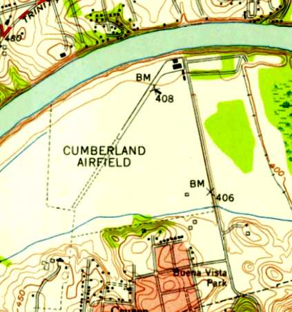
The 1952 USGS topo map depicted “Cumberland Airfield” as having a single northeast/southwest runway, of which the northeastern half was paved.
A paved ramp & 4 small buildings were depicted on the northeast side.
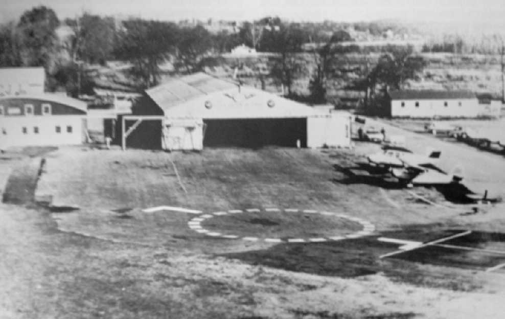
A circa 1950s aerial view of Cumberland Field (courtesy of David Stevenson) showed a Bonanza & a taildragger in front of 2 hangars.
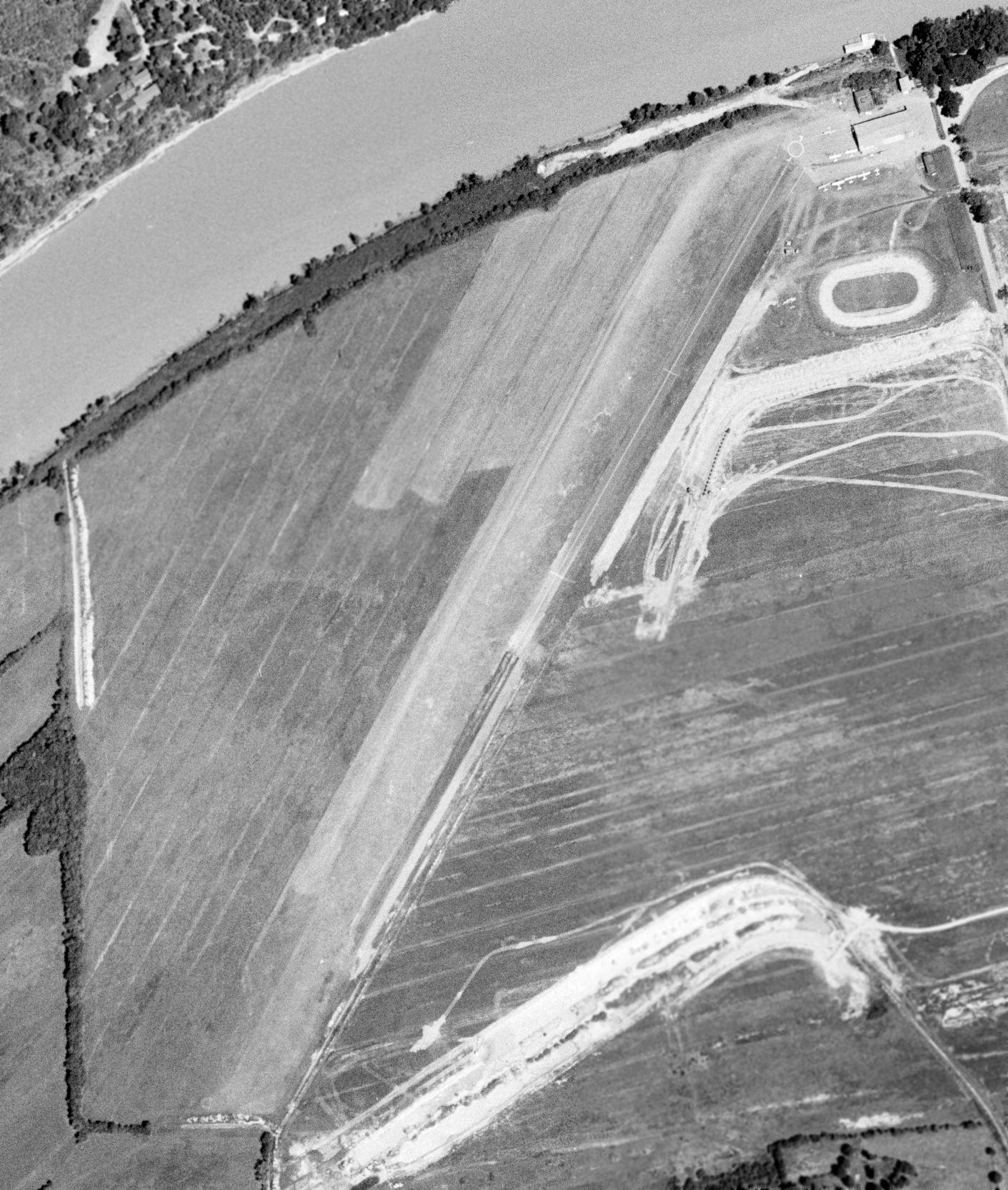
The last photo which has been located of Cumberland Field was a 7/6/59 USGS aerial view (courtesy of Dick Merrill).
It depicted Cumberland as having single northeast/southwest runway, of which the northeastern half was paved.
A hangar, a few small buildings, and 7 light single-engine aircraft were depicted on the northeast side.
According to the book “The Aviation History of Tennessee” by Jim Fulbright (courtesy of David Stevenson),
“Cumberland Field continued to operate into the early 1960s.”
The last depiction which has been located of Cumberland Field was on the 1965 Nashville Sectional Chart (courtesy of John Price),
which depicted Cumberland as having a 2,700' unpaved runway.
The book “The Aviation History of Tennessee” by Jim Fulbright (courtesy of David Stevenson)
observed of Cumberland Field, “The valuable land near the downtown area was eventually redeveloped.”
Cumberland Field was no longer depicted on the October 1970 Atlanta Sectional Chart (courtesy of Ron Plante).
A 1992 USGS aerial photo did not show any remaining trace of Cumberland Field.
An 8/1/11 aerial photo did not show any remaining trace of Cumberland Field.
The site of Cumberland Airport is located west of the intersection of Great Circle Road & Mainstream Drive.
____________________________________________________
(Original) Humphreys County Airport / Waverly Airport, Waverly, TN
36.078, -87.856 (West of Nashville, TN)
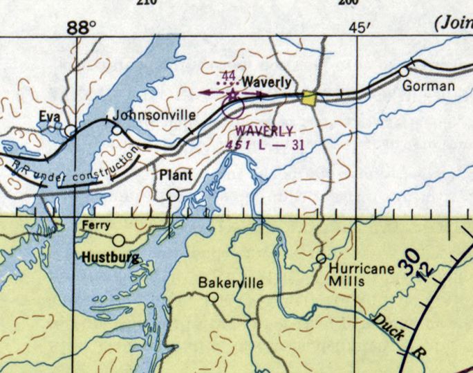
Waverly Airport, as depicted on the February 1950 Chattanooga Sectional Chart.
Photo of the airport has not been located.
Waverly Airport was not yet depicted on the October 1946 Nashville Sectional Chart (courtesy of Jim Stanton).
According to the book “The Aviation History of Tennessee” by Jim Fulbright (courtesy of David Stevenson),
“Waverly's first municipal airport was opened in 1947.
It was located on county property 3 miles west of Waverly on the north side of Highway 70.
It consisted of a 1,600' east/west turf strip which was licensed for public use.”
According to the book “The Aviation History of Tennessee” by Jim Fulbright (courtesy of David Stevenson),
“By 1949 the runway had been extended to 3,100'.
J.L. King managed the airport for the county.”
The earliest depiction which has been located of Humphreys County Airport was on the February 1950 Chattanooga Sectional Chart.
It depicted Waverly as having a 3,100' unpaved runway.
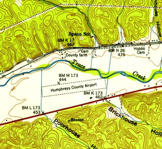
The 1950 USGS topo map depicted Humphreys County Airport
as having a single unpaved east/west runway with a single small building on the southeast side.
A 1958 USGS aerial photo depicted Humphreys County Airport as having a single unpaved east/west runway
with 1 light single-engine aircraft parked near some small buildings on the southeast side.
According to the book “The Aviation History of Tennessee” by Jim Fulbright (courtesy of David Stevenson),
“The field was unattended & without facilities until the 1950s.
By then a large metal hangar was constructed & the runway was lighted.”
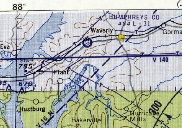
The last depiction which has been located of the original Humphreys County Airport was on the February 1960 Chattanooga Sectional Chart.
It depicted Humphreys County as having a 3,100' unpaved runway.
According to the book “The Aviation History of Tennessee” by Jim Fulbright (courtesy of David Stevenson),
“In 1964 the county began building a new high school on the property & the Waverly Airport was closed.”
Waverly Airport was no longer depicted on the August 1965 Chattanooga Sectional Chart,
which instead depicted a new Humphreys County Airport having been built several miles to the east.
The 1970 USGS topo map still showed the outline of the western portion of the former Waverly Airport runway,
but the new high school covered the eastern portion.
A 1973 USGS aerial photo did not show any remaining trace of Waverly Airport.
A 4/9/10 aerial photo did not show any remaining trace of Waverly Airport.
The site of Waverly Airport is located north of the intersection of Route 70 & Curtis Drive.
____________________________________________________
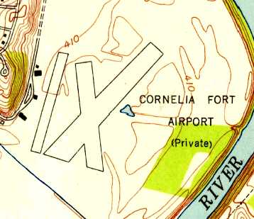
Cornelia Fort Airport / Cornelia Fort Airpark (M88), Nashville, TN
36.19, -86.703 (Northeast of Downtown Nashville, TN)
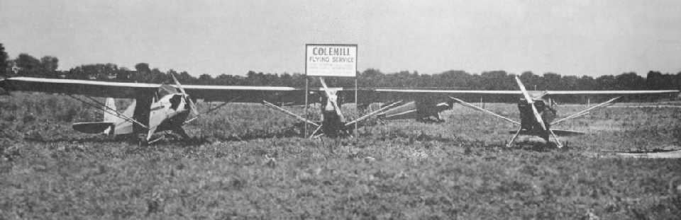
A 1945 photo of 4 taildraggers with a sign for the Colemill Flying Service at Cornelia Fort Airport (courtesy of David Stevenson).
According to the book “The Aviation History of Tennessee” by Jim Fulbright (courtesy of David Stevenson),
“In late 1944 Norman Thomas purchased 200 acres along a bend of the Cumberland River.
Because the property adjoined part of a farm owned by Rufus Fort,
Thomas named the airfield in honor of Fort's daughter, Cornelia.
Fort was one of the the original 5 members of the Women's Auxiliary Ferrying Squadron.
She died in an aircraft accident in 1943, becoming the first female pilot in US history to be killed on active military duty.”
Logan Colbert reported, “My Grandfather was Ernest Colbert.
He started Colemill in December of 1944 in the north hangar on the Cornelia Fort property.”
However, Cornelia Fort Airpark was not yet listed among active airfields in the 1945 AAF Airfield Directory (courtesy of Scott Murdock).
The earliest depiction which has been located of Cornelia Fort Airport
a 1945 photo of 4 taildraggers with a sign for the Colemill Flying Service at Cornelia Fort Airport (courtesy of David Stevenson).
The earliest depiction which has been located of Cornelia Fort Airport
was on the October 1946 Nashville Sectional Chart (courtesy of Jim Stanton),
which depicted it as a commercial/municipal airport.
According to a 2010 FAA Airport/Facility Directory entry, Cornelia Fort Airpark was established in 11/1946,
but that date is obviously somewhat erroneous.
A sad 1950 aerial view looking north at a flooded Cornelia Fort Airport.
Logan Colbert reported, “My Grandfather was Ernest Colbert. He bought [Cornelia Fort] Airport in 1951.”
A 1951 aerial photo depicted Cornelia Fort Airport as having 2 unpaved runways,
with 18 light aircraft parked around several hangars on the west side.
The earliest topo map depiction which has been located of Cornelia Fort Airport was on the 1952 USGS topo map.
It depicted the field as having 2 runways, with a ramp & 4 small buildings on the west side.
According to Wikipedia, “In the early 1950s Ernest Colbert bought out his partner to become sole owner (operating it as Colemill Enterprises).”
A 10/23/53 USGS aerial photo depicted Cornelia Fort Airport as having 2 unpaved runways & several hangars on the west side.
The 1965 Nashville Sectional Chart (courtesy of John Price) depicted Cornelia Fort as having a 3,000' unpaved runway.
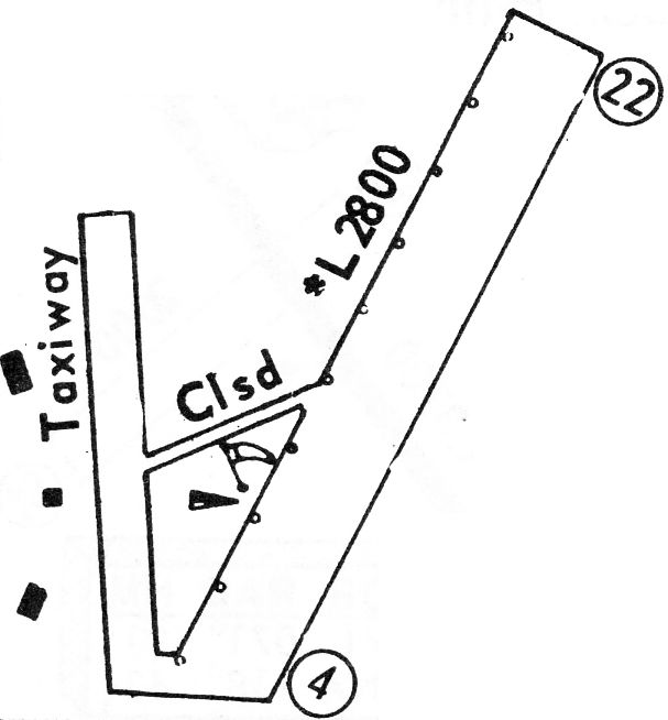
The 1968 Flight Guide (courtesy of Robert Levittan) depicted Cornelia Fort Airport
as having a single 2,800' unpaved Runway 4/22, with a taxiway & 3 small buildings on the west side.

The last aeronautical chart depiction which has been located of Cornelia Fort Airpark was on the November 1991 St. Louis Sectional Chart.
It depicted Cornelia Fort as having a 2,500' paved northeast/southwest runway.
Cornelia Fort Airpark evidently gained a paved runway at some point between 1968-97,
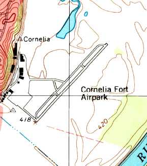
as the 1997 USGS topo map depicted it as having a single paved northeast/southwest runway with a parallel taxiway,
and a ramp & a cluster of buildings along the west side.
A 3/1/97 aerial view looking northeast at Cornelia Fort Airpark
evidently showed construction in progress to extend Runway 4/22 further to the southwest.
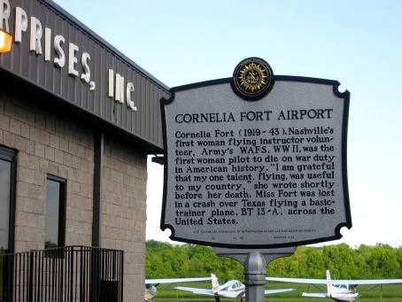
An undated (circa 2000-2011) photo of the historical plaque at Cornelia Fort Airport, in front of the Colemill Enterprises Building.
Ironically, although the plaque is entitled “Cornelia Fort Airport”,
it says absolutely nothing about the airport, instead summarizing the history of the airport's namesake.
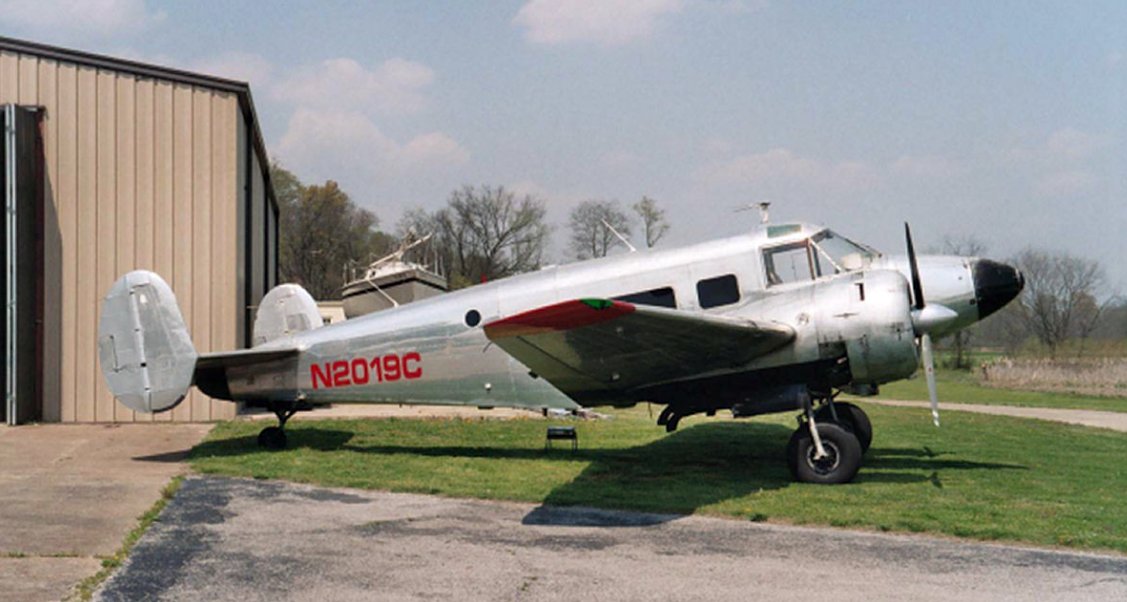
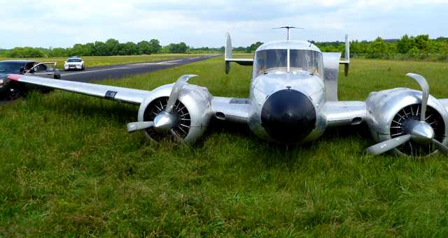
An 8/4/04 photo of Beech G18S N2019C BA-573 at Cornelia Fort Airpark.
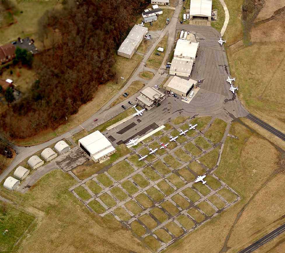
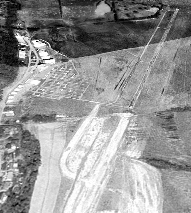
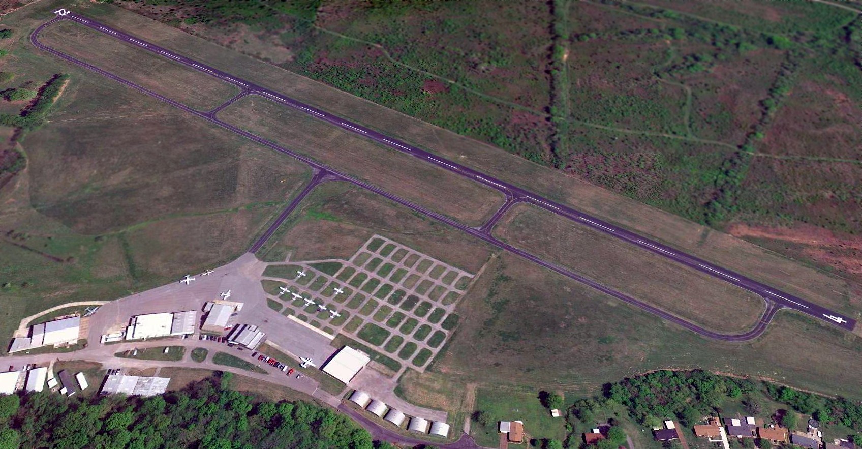
An undated (circa 2007-2011?) aerial view looking north at Cornelia Fort Airpark,
showing a dozen aircraft, but also a large number of empty parking spaces.
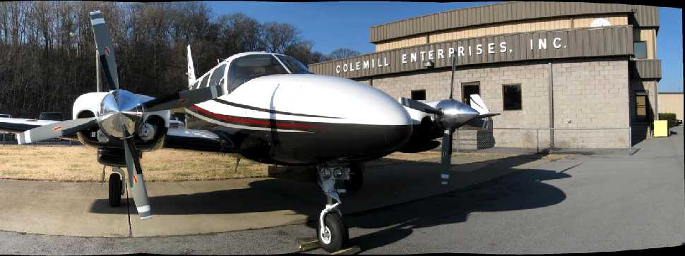
An undated (circa 2007-2011?) photo showing a pretty twin Cessna in front of the Colemill Enterprises building at Cornelia Fort Airpark,
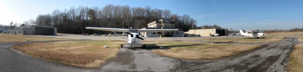
An undated (circa 2007-2011?) panoramic photo looking northwest at 2 Cessna 172 on Cornelia Fort's ramp.
A 4/12/10 aerial view looking east showed a dozen planes parked outside at Cornelia Fort Airpark, less than a month before the flood that sealed its fate.
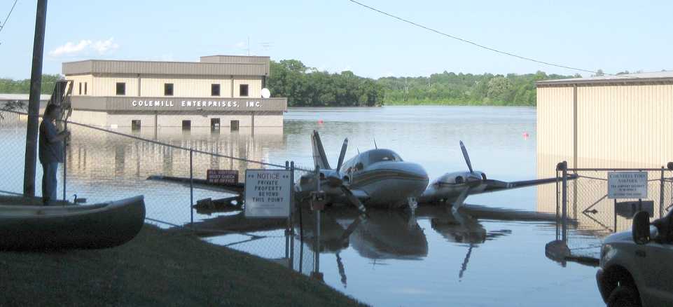
A sad 5/3/10 photo looking north at the result of the 2010 flood, showing a partially submerged Beech Baron in front of the Colemill Enterprises building.
According to Jon Bailey, “The May 2010 flood sealed its fate.”
According to Wikipedia, airport owner Ernest Colbert sought a buyer for Cornelia Fort Airpark
after defaulting on a $1.4 million loan in 2010 (after it was inundated in the 2010 Tennessee floods).
According to a 2010 FAA Airport/Facility Directory entry, Cornelia Fort Airpark covered an area of 300 acres,
had a single 3,500' asphalt Runway 4/22, was owned by Colemill Enterprises, and the Manager was Scott White.
The airport was said to have 27 based aircraft, and to conduct an average of 82 takeoffs or landings per day.
According to Wikipedia, in 2011 the city of Nashville acquired the 141 acre airport to include it as non-aviation part of Shelby Park.
Jon Bailey reported in 2011, “Cornelia Fort has closed.”
An 8/2/11 aerial photo showed closed-runway “X” markings on Cornelia Fort's runway,
but the airport otherwise remained completely intact.
An April 2012 photo of a Beech 18 which landed gear-up at Cornelia Fort more than a year after the airport closed.
According a 4/22/12 Nashville Police Department press release, “Metro Police & the Federal Aviation Administration
are working to identify the person or persons who crash landed a 1961 Beechcraft twin-engine airplane on grass at the closed Cornelia Fort Airpark in East Nashville.
The airpark has been out of operation for a number of months & is presently under the control of the Metro Parks Department.
Large yellow Xs are painted on the runway as a sign to aircraft that the facility is closed.
A Parks Department maintenance worker noticed the airplane in the grass to the left of the runway Saturday morning.
When it was still there today, the worker notified Parks Police officers.
The landing gear mechanism on the airplane apparently became inoperable.
It is believed the pilot(s) cut the engines before belly-landing the plane in a large grassy area adjacent to the runway.
Markings in the grass show that the plane traveled about 2/10th of a mile before coming to a stop. The propellers & engines show obvious damage.
The plane is registered to Great American Transportation, Inc., which lists its address as Cornelia Fort Airpark.
The plane is believed to have been housed at the airpark in the past.
At this point, it is unknown who or what was onboard the airplane. There is no indication that anyone was seriously injured.
No cargo or contraband was located when officers arrived today.
The airplane was not in contact with the Nashville control tower, nor was a flight plan filed.
It likely arrived in the dark late Friday or early Saturday.
Officers & the FAA will also be working to learn the plane’s whereabouts over the past several weeks.”
A 2014 photo by Jonathan Westerling of an undated photo of Cornelia Fort Airpark's terminal building, part of a Metropolitan Nashville Airport display by Jeff Cashdollar about the history of Cornelia Fort Airpark.
A 2014 photo by Jonathan Westerling of an undated photo of Cornelia Fort Airpark's runway, part of a Metropolitan Nashville Airport display by Jeff Cashdollar about the history of Cornelia Fort Airpark.
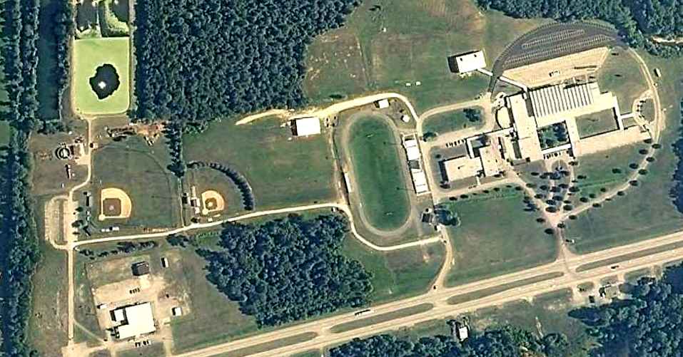
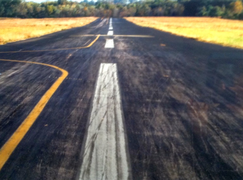
A 2017 photo looking northeast along the former Cornelia Fort Airpark runway.
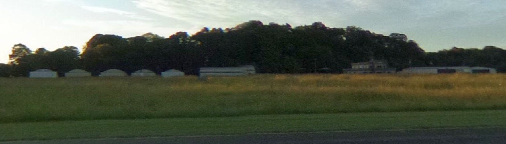
A 2017 photo looking northwest at the former Cornelia Fort Airpark hangars.
A 2017 aerial view looking east showed Cornelia Fort Airpark to remain intact. What a shame for this nice airport to not be used by the aviation community.
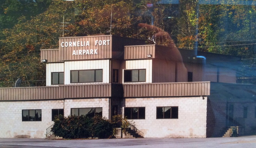
A 2023 photo looking northeast at the former Cornelia Fort Airpark hangars & terminal building.
Cornelia Fort Airpark is located east of the intersection of Shadow Lane & Airpark Drive, appropriately enough.
____________________________________________________
Parsons Municipal Airport / Scott Field, Parsons, TN
35.64, -88.13 (Southwest of Nashville, TN)
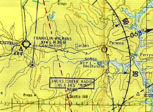
Scott Field, as depicted on the January 1961 Chattanooga Sectional Chart (courtesy of Chris Kennedy).
This general aviation airport was not yet depicted on the August 1956 Sectional Chart (according to Chris Kennedy).
According to the book “The Aviation History of Tennessee” by Jim Fulbright (courtesy of David Stevenson),
“Parsons Municipal Airport was established in December 1959.
The limited facilities originally consisted of a 2,900' chert runway.”
The earliest depiction which has been located of Scott Field
was on the January 1961 Chattanooga Sectional Chart (courtesy of Chris Kennedy).
It depicted the field as having a 3,200' unpaved runway.
Scott Field evidently gained a paved runway at some point between 1961-86,
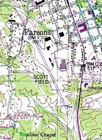
as the 1986 USGS topo map depicted Scott Field as having a single paved northwest/southeast runway,
with a few small buildings along the east side.
The earliest photo which has been located of Scott Field was a 1997 USGS aerial view looking southwest.
It depicted the field as having a single paved Runway 15/33, with a taxiway leading to a small ramp on the east side with a few small hangars.
No aircraft were visible in the photo.
The last aeronautical chart depiction which has been located of Scott Field
was on the April 2004 Memphis Sectional Chart (courtesy of Chris Kennedy).
It depicted the field as having a single paved 4,000' runway.
A larger Beech River Regional Airport opened in 2006 a few miles to the northwest.
Scott Field was closed on 7/1/06, according to Damon Morris.
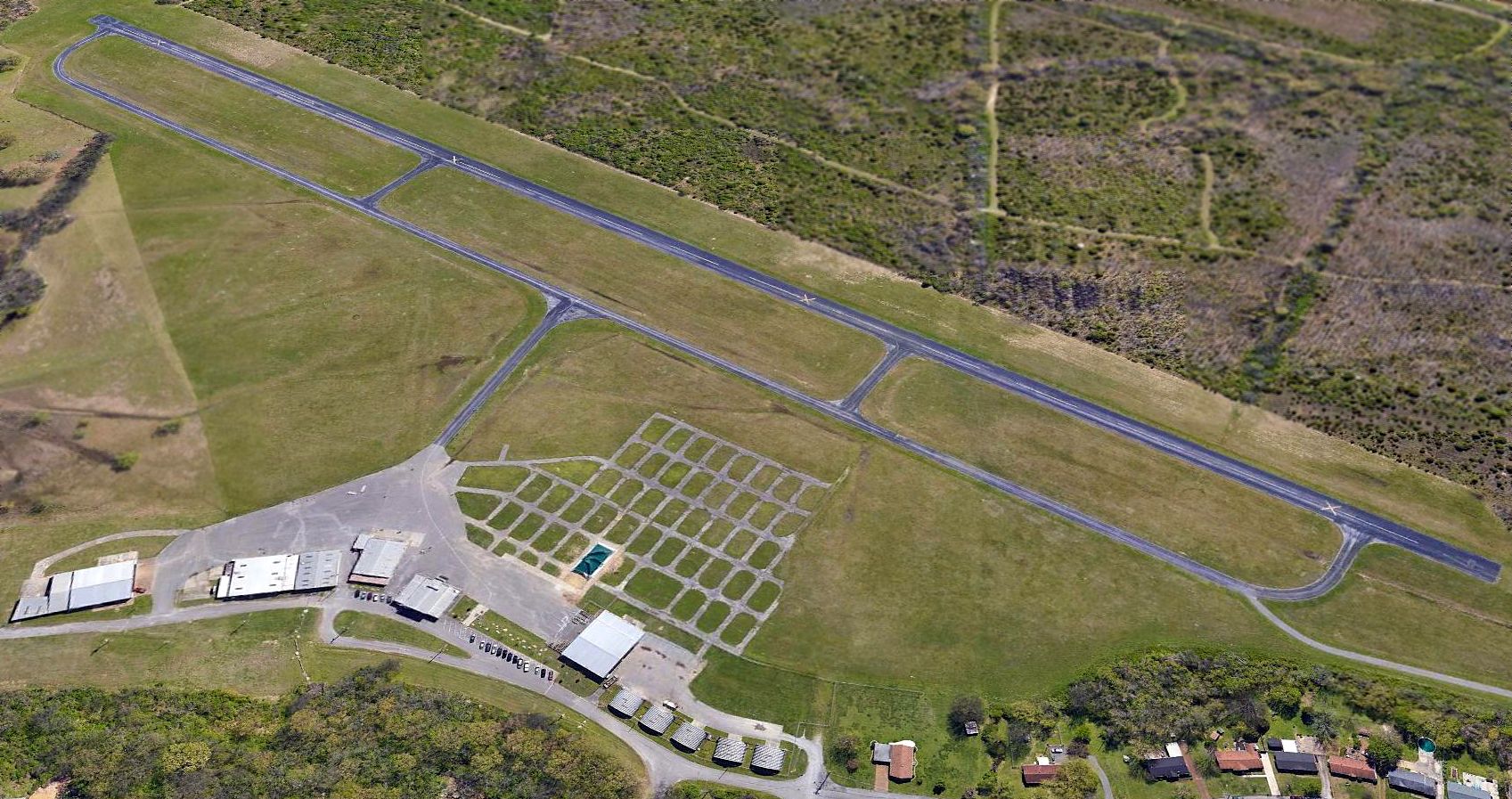
The last photo which has been located showing Scott Field remaining intact was a 2012 aerial view looking southwest.
Although the runway was painted with closed-runway “X” symbols, the airport otherwise remained intact.
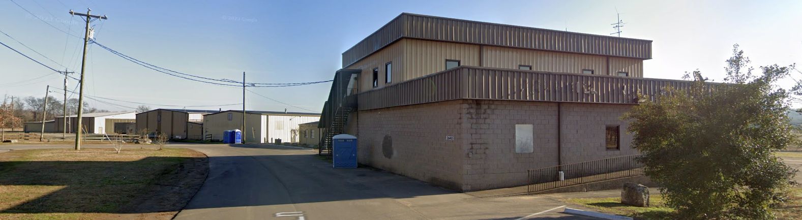
A July 2013 photo looking west at former Scott Field hangars.
Stephen Brookfield observed that a 2015 aerial photo shows baseball diamonds had been constructed over the southern portion of Scott Field's runway at some point between 2012-2015.
The site of Scott Field is located west of the intersection of West Holly Street & West 9th Street.
Thanks to Chris Kennedy for pointing out this airfield.
____________________________________________________
Blackwood Field, Old Hickory, TN
36.22, -86.607 (Northeast of Nashville, TN)
An undated photo of Army biplanes (type undetermined) at Blackwood Field (courtesy of the TN State Library, via Marvin Maes).
This former military airfield is located on the property of The Hermitage (the home of President Andrew Jackson).
Blackwood Field was opened in 1921 to house the First Squadron, Air Service, Tennessee National Guard.
The airfield property consisted of 100 acres, on which 2 hangars were erected.
The historical marker at the site (pictured above) indicates
that H.O. Blackwood gave $1,000 to aid the construction of the field.
However, a history of the squadron indicates that H.O. Blackwood donated a farm adjacent to The Hermitage,
and that a WW1-era hangar was moved from Memphis to the site.
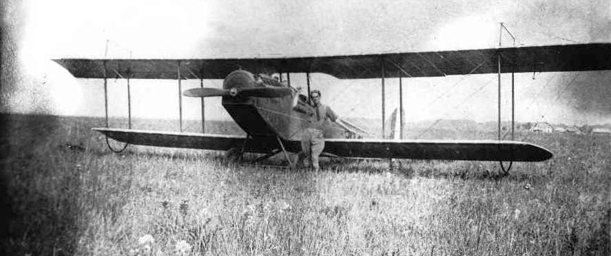
A circa 1920-25 photo of an unidentified pilot in front of an Army JN-4 Jenny biplane at Blackwood Field.
The flying unit at Blackwood Field was redesignated the 136th Air Observation Squadron at the end of 1921,
and operated four new Curtiss JN-6HG Jennys & one DeHavilland DH-4B aircraft.
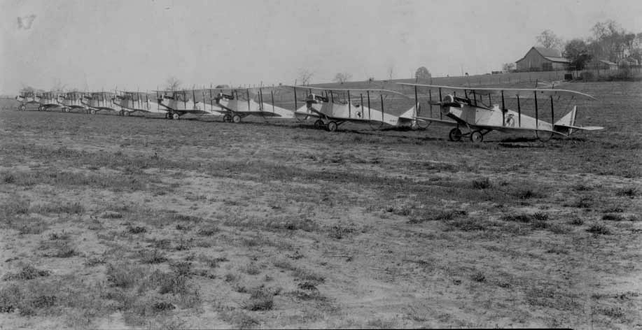
A circa 1922-28 photo of 9 Army JN-4 Jenny biplanes at Blackwood Field.
Blackwood's squadron was further redesignated the 105th Observation Squadron in 1923.
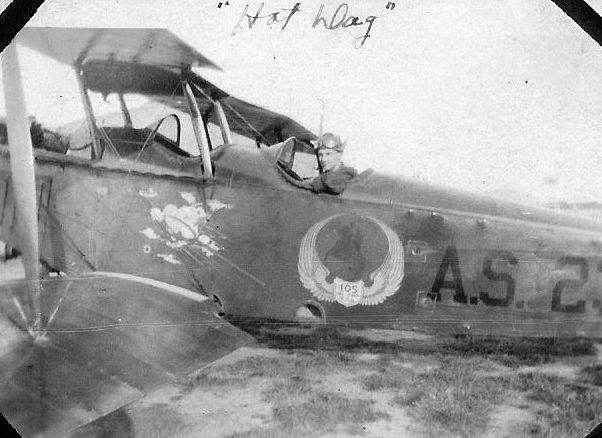
A circa 1920s photo (courtesy of Jim Wheeler) of Jim Wheeler's grandfather in a 105th Observation Squadron JN-4 Jenny biplane at Blackwood Field.
Jim Wheeler reported, “My grandfather was a member of the 105th & was a mechanic & a pilot.
We found these recently while looking though my granddad's trunk that had been closed up for 70 years.”
The first airmail flight from Nashville was conducted from Blackwood Field to Chicago in 1924.
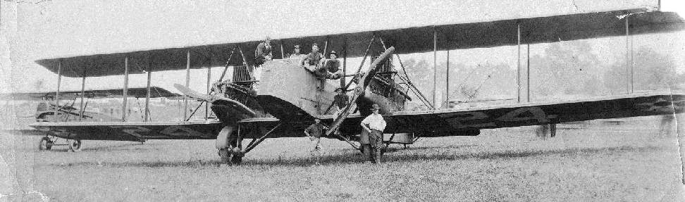
A photo of J.W.Ray sitting on a Martin B-2 bomber at Blackwood Field in 1924.
Blackwood's 105th Observation Squadron received 0-2 observation airplanes in 1926.
According to Peggie Black, "My grandfather, Frank McCampbell was a member of the 105th AS based out of Blackwood Field."
According to an article in the 12/21/03 issue of The Tennessean (courtesy of Marvin Maes),
the poor condition of the unpaved roads leading to Blackwood Field (and the cost of improving them)
removed Blackwood from contention for serving as a permanent airmail airfield for Nashville.
The increasing use of airmail also brought about the need for a closer airport to Nashville,
eventually leading to the establishment of McConnell Field (west of downtown Nashville) in 1927.
The 105th Observation Squadron relocated to McConnell Field in 1927.
According to the book “The Aviation History of Tennessee” by Jim Fulbright (courtesy of David Stevenson),
“Although local pilots continued to use Blackwood Field for a time, it was closed in 1928.”
Nothing was depicted at the site of Blackwood Field on the 1932 USGS topo map.
The site of Blackwood Field remained an undeveloped field on a 1951 aerial photo.
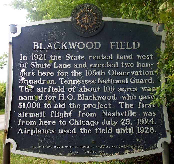
A 8/02 photo by Paul Freeman of a historical marker which was erected in 1970 along the west side of Shute Lane, the eastern boundary of the site of Blackwood Field.
Remains of concrete footings are visible from adjacent Shute Lane when vegetation doesn’t block the view.
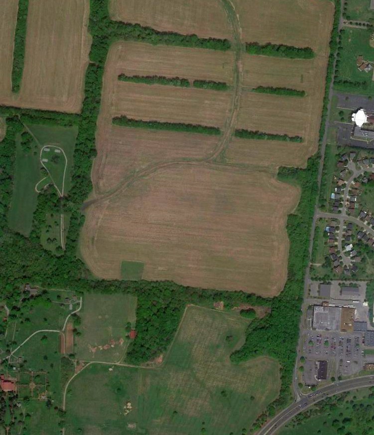
A 2014 aerial view of the general location of Blackwood Field.
The site of Blackwood Field is located northwest of the intersection of Shute Lane & Lebanon Pike.
Thanks to Marvin Maes for pointing out this field.
See also: http://198.65.138.161/military/agency/usaf/118aw.htm
____________________________________________________
UL>
Or if you prefer to contact me directly concerning a contribution (for a mailing address to send a check),
please contact me at: paulandterryfreeman@gmail.com
If you enjoy this web site, please support it with a financial contribution.
____________________________________________________
This site covers airfields in all 50 states.