Abandoned & Little-Known Airfields:
Eastern Tennessee
© 2002, © 2024 by Paul Freeman. Revised 9/1/24.
This site covers airfields in all 50 states: Click here for the site's main menu.
____________________________________________________
Please consider a financial contribution to support the continued growth & operation of this site.
Cleveland Airport / Hardwick Field (revised 4/25/23) - Dallas Bay Skypark (revised 4/25/23) - Dunlap Airfield (revised 9/1/24) - Powell Airport / Powell STOLPort (revised 4/25/23)
Putnam County Airport (revised 11/29/21) - Roane County Airport (revised 11/3/21) - Smithville Intermediate Field (revised 5/6/18) - Tusculum Field (revised 4/25/23)
____________________________________________________
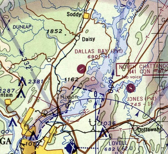
Dallas Bay Skypark (1A0, 1AA0), Hixson, TN
35.188, -85.177 (Northeast of Chattanooga, TN)
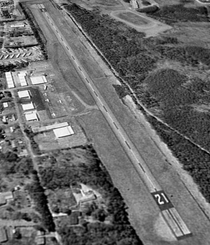
Dallas Bay Skypark, as depicted on the February 1965 Chattanooga Sectional Chart.
According to Wikipedia, “Dallas Bay Skypark began as the Optimist Club Drag Strip back in the late 1950s.”
Dallas Bay Skypark was not yet depicted on the 1961 Chattanooga Sectional Chart.
According to Wikipedia, “In the early 1960s the dragstrip was moved to East Ridge, and John Flewellen & his family bought the old dragstrip & turned it into a private runway.”
The earliest depiction which has been located of Dallas Bay Skypark was on the February 1965 Chattanooga Sectional Chart.
It depicted Dallas Bay as a private airfield having a single paved northeast/southwest 3,100' runway.
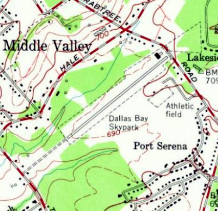
The earliest topo map depiction which has been located of Dallas Bay Skypark was on the 1969 USGS topo map.
It depicted Dallas Bay Skypark as having a single paved northeast/southwest runway, with 1 small building on the northeast side.
According to Wikipedia, “In the early 1970s the airstrip became an FAA-certified public airport with the designation 1A0.”
According to its FAA Airport/Facility Directory data, Dallas Bay Skypark conducted an average of 28 daily takeoffs or landings for the year ending 5/4/98, 100% of which were general aviation.
According to article in the 4/27/21 Chattanooga Times Free Press,
“John Osterhage said his group bought Dallas Bay in 2002 when the owner was going to sell it to a real estate developer.”
 The
earliest photo which has been located of Dallas Bay Skypark was an
April 2019 photo looking southwest.
The
earliest photo which has been located of Dallas Bay Skypark was an
April 2019 photo looking southwest.
One light single-engine plane was depicted on the paved runway, and another was visible on the southeast ramp.
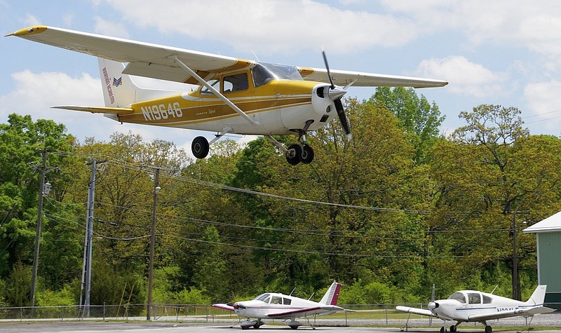
A
2021 photo of a Cessna 172 landing at Dallas Bay Skypark.
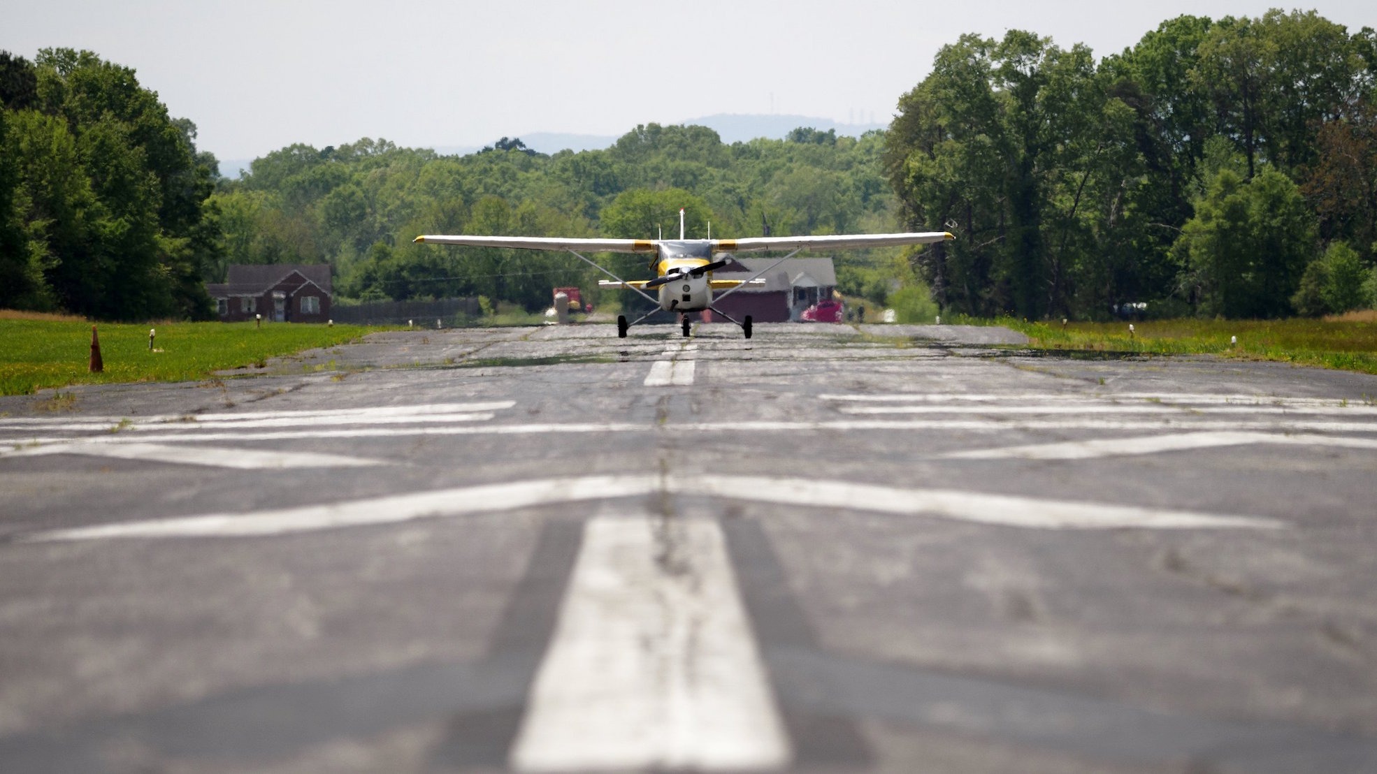
A 2021 photo of a Cessna 172 on the Dallas Bay Skypark runway.
According to Wikipedia, “In April 2021, the airport owners notified tenants that the airport would close before the end of the year.”
An article entitled “Dallas Bay airport in Hixson plans to close after nearly 60 years” in the 4/27/21 Chattanooga Times Free Press by Mike Pare reported,
“Dallas Bay Skypark, a private airport in Hixson that's open to the public & small aircraft, plans to permanently close later this year after nearly 6 decades of operation, an official says.
John Osterhage, president of airport owner Aviation Integrated Resources Inc.,
said in a memo to the renters of the more than 30 hangars at the facility that Dallas Bay likely will close in late summer or early fall.”
“I'll be sad to see it go as a pilot," he said.
He declined to say what Aviation Integrated plans to do with the 56-acre tract, adding that he "can't get into those details due to confidentiality.
I can't comment on anything related to a potential sale."
For the planned closure, Osterhage blamed TDOT's Aviation Division & nearby homeowners who've refused to cut down tall trees near the 1-runway airfield.
He said TDOT "has notified us that the trees on the approach end are a sufficient enough hazard to flight operations that they will revoke our airport operating license later this year."
Osterhage also said TDOT informed the Dallas Bay owner that it would no longer fund runway work such as repairs & repaving for private airports.
"This is a major change as twice the runway was repaired, sealed, painted by TDOT since 2002," he said.
"The estimated cost to repair is many, many times our annual revenue."
But TDOT said in response to questions that the airport's license expired at the end of 2020
and that, per a communication earlier this month, the owner isn't seeking to renew it.
"TDOT is not revoking the airport license," said TDOT spokeswoman Rae-Anne Bradley in an email.
TDOT also said airports such as Dallas Bay, which are privately owned but public use,
are eligible for state funding for projects that add to the safety of the airport & assist in meeting state licensing requirements.
"The airport owner is responsible for maintenance of the facility," Bradley said. "This has been the department's policy since 2002."
However, Osterhage said he has a letter from TDOT "that specifically said they're revoking" the airport's license.
Concerning the runway, the owner said he was told by a TDOT employee that if the runway was "a bad enough safety issue, they'd come in and do something."
Osterhage said he didn't want a chunk of asphalt to come loose & compromise safety.
The airport sells fuel & a separate business, Hixson Aviation, offers flight training & aircraft rental.
Mark Winton of Hixson Aviation said he received the memo from Aviation Integrated but didn't want to comment further.
A sad December 2021 photo looking southwest at Dallas Bay Skypark, devoid of aircraft.
According to its FAA Airport/Facility Directory data, Dallas Bay Skypark's operations had decreased to only 8 monthly takeoffs or landings for the year ending 3/16/22.
The 2023 Sectional Chart depicted Dallas Bay Skypark as a private airfield having a single paved northeast/southwest 3,000' runway.
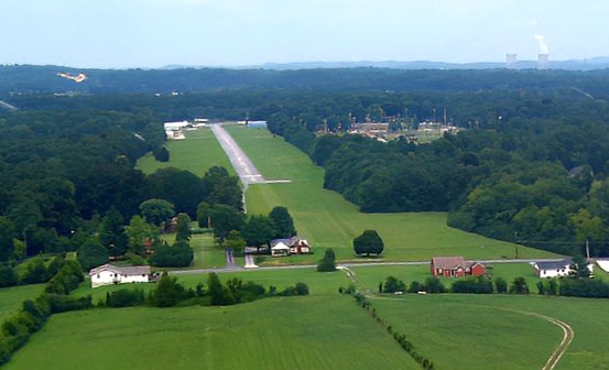
A 2023 aerial view by Robert Morris looking northeast at Dallas Bay Skypark.
As of 2023, the FAA Airport/Facility Directory described Dallas Bay Skypark as having a single 3,037' asphalt Runway 5/23, in fair condition.
It was said to be privately-owned by Aviation Integrated Resource Inc., managed by John Ostrerhage,
and to have 6 aircraft based on the field: 4 single-engine & 2 multi-engine.
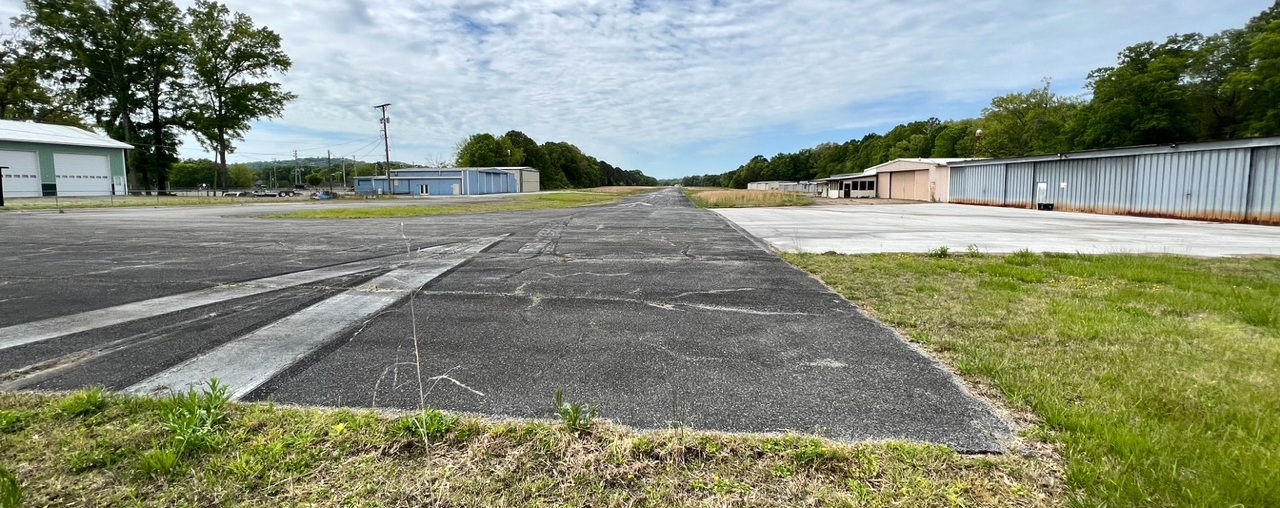
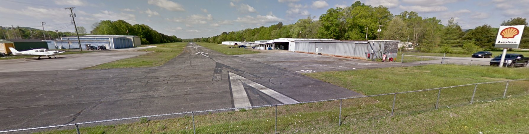
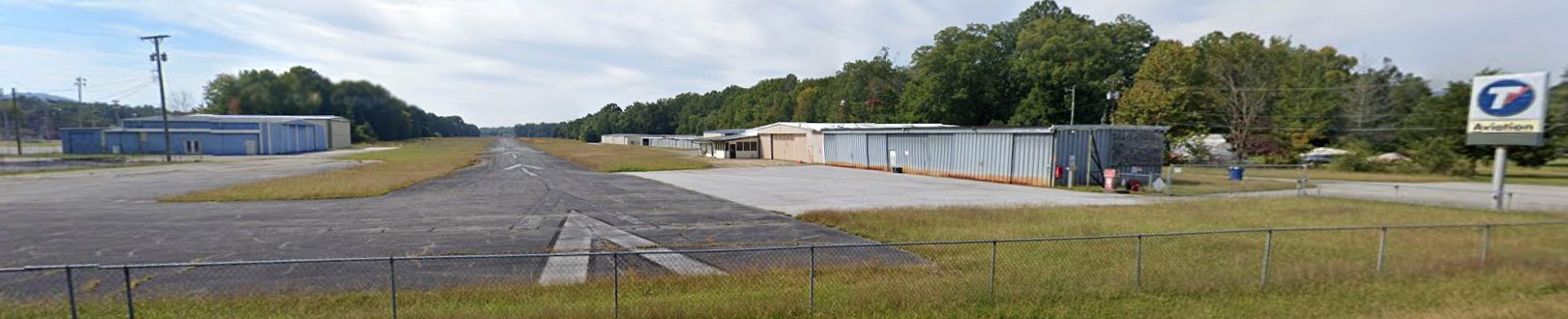
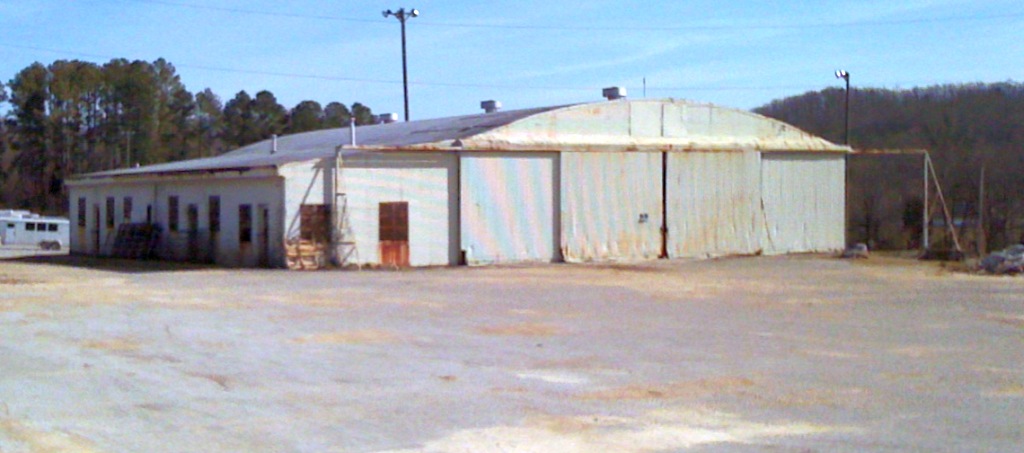
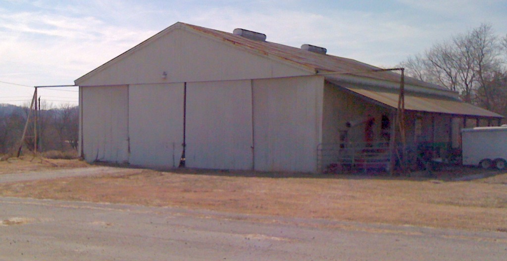
A 4/25/23 photo by Robert Morris looking southwest along the closed Dallas Bay Skypark runway.
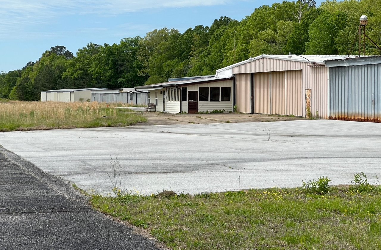
A 4/25/23 photo by Robert Morris looking west at the office & hangars of the closed Dallas Bay Skypark.
Thanks to Robert Morris for pointing out this airfield.
____________________________________________________
Smithville Intermediate Field, Smithville, TN
35.96, -85.79 (Southeast of Nashville, TN)
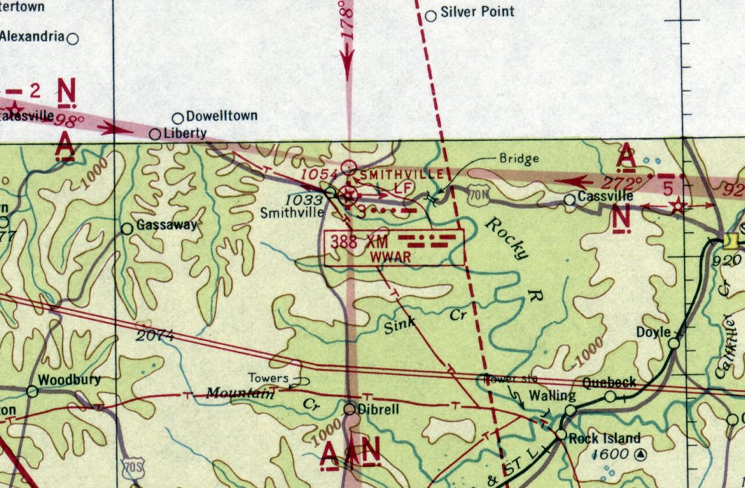
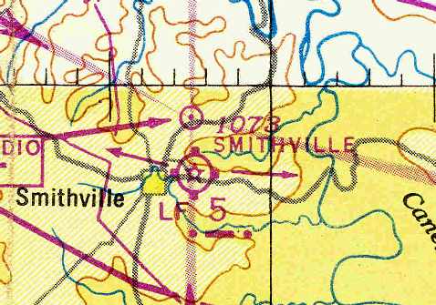
Smithville Intermediate Field, as depicted on the July 1940 Chattanooga Sectional Chart.
The Smithville Intermediate Field was one of the Department of Commerce's network of fields
which were established in the 1930s for the emergency use of commercial aircraft flying airways between major cities.
Smithville was not yet listed among active airfields in the 1934 Department of Commerce Airfield Directory (according to Chris Kennedy)
nor depicted on the January 1936 Chattanooga Sectional Chart.
According to the book “The Aviation History of Tennessee” by Jim Fulbright (courtesy of David Stevenson),
“The first airport at Smithville was established in the mid-1930s
as a U.S. Department of Commerce emergency airfield on the Nashville-to-Washington airway.”
The earliest reference which has been located to the Smithville Intermediate Field
was in The Airport Directory Company's 1938 Airport Directory (courtesy of Chris Kennedy).
It described Smithville as the Department of Commerce's Site 3 along the Nashville-Washington Airway.
The field was said to consists of 2 runways in a cross shape,
measuring 3,420' east/west & 2,400' north/south.
The earliest depiction which has been located of the Smithville Intermediate Field was on the July 1940 Chattanooga Sectional Chart.
It depicted Smithville as Commerce Department Site 3.
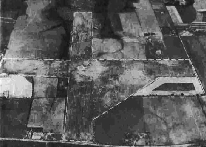
The only photo which has been located showing the Smithville Intermediate Field while it was operational
was a 10/29/43 aerial view looking north from the 1945 AAF Airfield Directory (courtesy of Scott Murdock).
It depicted Smithville as having 2 grass runways.
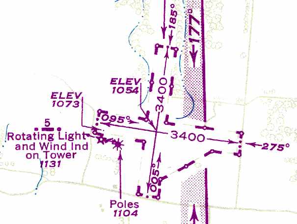
The 1945 AAF Airfield Directory (courtesy of Scott Murdock) described Smithville Intermediate Field
as a 79 acre irregularly-shaped property having 2 sod runways, measuring 3,420' east/west & 3,400' north/south.
The field was not said to have any hangars, to be owned by private interests,
and operated by the Civil Aeronautics Administration.
The designation of the Smithville Intermediate Field had evidently been changed at some point between 1941-46,
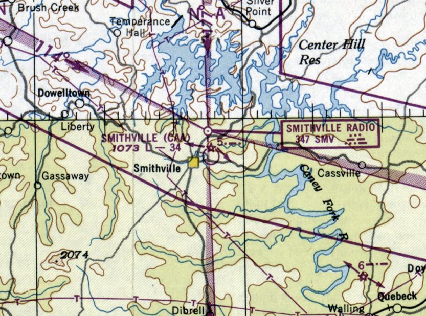
as the October 1946 Chattanooga Sectional Chart (courtesy of Chris Kennedy) labeled Smithville as Site 5.
The 1949 USAF Pilot's Handbook (courtesy of Chris Kennedy)
depicted Smithville Intermediate Field as having two 3,400' unpaved runways.
The last depiction which has been located of Smithville Intermediate Field as an active airfield
was on the February 1950 Chattanooga Sectional Chart.
It depicted “Smithville (CAA)” as having a 3,400' unpaved runway.
Smithville Intermediate Field was evidently closed at some point between 1950-54,
as it was no longer depicted at all on the August 1954 Chattanooga Sectional Chart (courtesy of Chris Kennedy).
It had lasted somewhat longer than many other Intermediate Fields,
many of which were no longer needed due to advances in the range & reliability of commercial aircraft.
The 1984 USGS topo map still depicted the outline of the Smithville airfield,
although it was no longer labeled as such.
The map also labeled the road bordering the west side of the property as “Airport Road”
(although later street maps show that it was evidently renamed “Smith Road” at some point between 1984-2005).
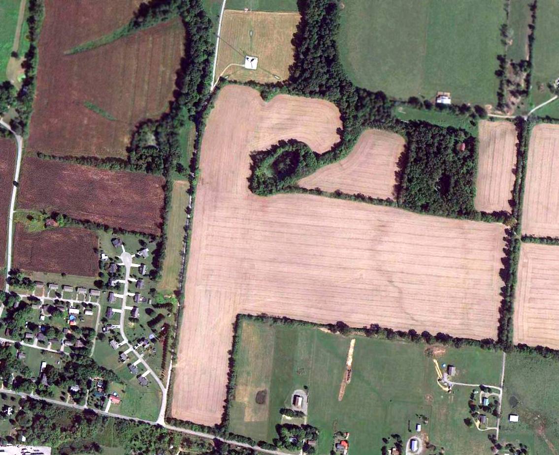
A 2014 aerial photo showed that the outline of the former Smithville Intermediate Field runways was still quite recognizable.
There do not appear to be any buildings at the site related to its time as an airfield.
The site of Smithville Intermediate Field is located northeast of the intersection of Smith Road & Steeplechase Drive.
____________________________________________________
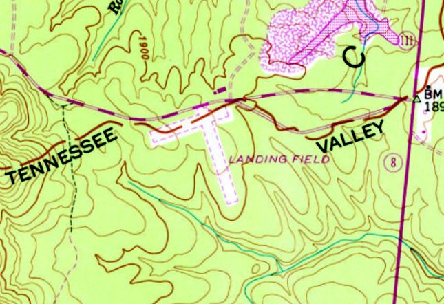
35.531,-85.479 (North of Chattanooga, TN)

Dunlap Airfield, as depicted on a 3/26/51 USGS aerial view.
Photo of the airfield while in use has not been located.
Not much is known about this small airfield, including its name or purpose.
Dunlap Airfield was evidently constructed in 1951,
as a 3/26/51 USGS aerial photo showed 2 perpendicular runways in the process of being constructed.
Dunlap Airfield was was not yet depicted on the 1955/60/68 Chattanooga Sectional Charts or the 1948/62/65 USGS topo maps.
The earliest topo map depiction which has been located of Dunlap Airfield was on the 1974 USGS topo map.
It depicted 2 perpendicular unpaved runways, labeled simply as “Landing Field”, with 2 small buildings on the opposite side of the road to the north.
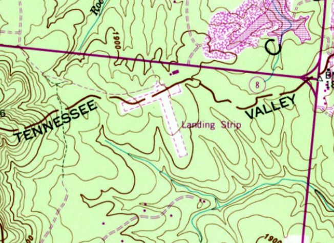
The 1992 USGS topo map showed that Route 8 had been rerouted away from the airfield, farther north.
Dunlap Airfield was still depicted as 2 perpendicular unpaved runways, labeled simply as “Landing Strip”.
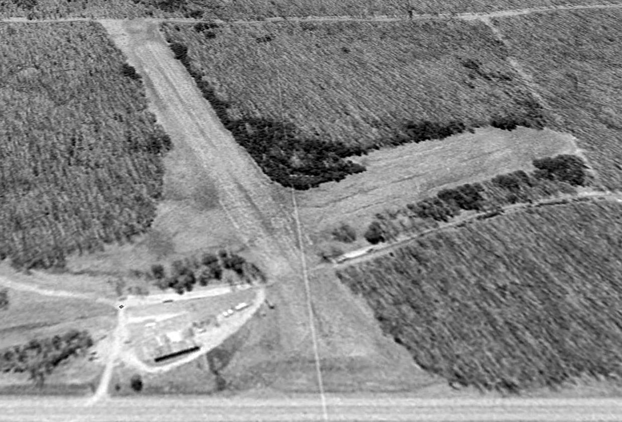
The earliest photo which is available of Dunlap Airfield was a 1997 USGS aerial view looking south.
It depicted Dunlap Airfield as having 2 perpendicular unpaved runways, with a small building on the northeast side. No aircraft were visible on the field.
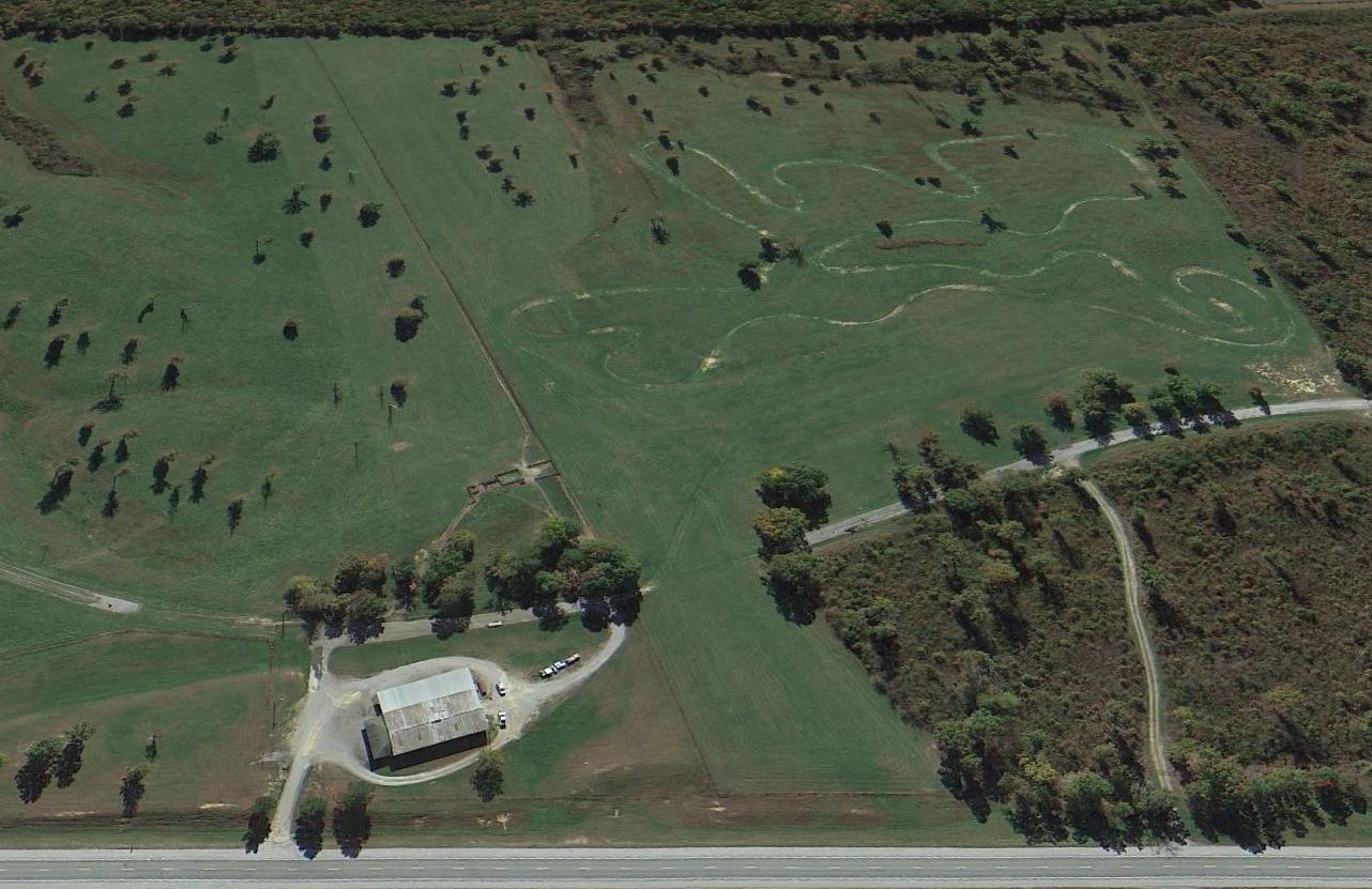
A 2014 aerial view looking south showed Dunlap Airfield's runways to remain intact, but there was no indication of any recent aviation usage.
As of 2016, there was no airfield depicted at this location on aeronautical charts.
The site of Dunlap Airfield is located at southwest of the intersection of Route 111 & Route 8.
Thanks to Bret Kepner for pointing out this airfield.
____________________________________________________
Cleveland Airport / Hardwick Field (KHDI), Cleveland, TN
35.22, -84.83 (Southwest of Knoxville, TN)

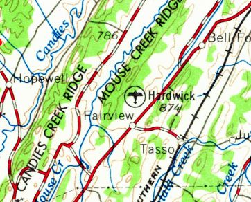
Cleveland Airport, as depicted on the February 1950 Chattanooga Sectional Chart.
Cleveland Airport was evidently constructed at some point between 1946-50,
as it was not yet depicted on the October 1946 Chattanooga Sectional Chart.
The earliest depiction which has been located of Cleveland Airport
was on the February 1950 Chattanooga Sectional Chart,
which depicted Cleveland as having a 2,400' unpaved runway.
Cleveland Airport was evidently renamed Hardwick Field at some point between 1950-57,
as that is how it was labeled on the 1957 USGS topo map.
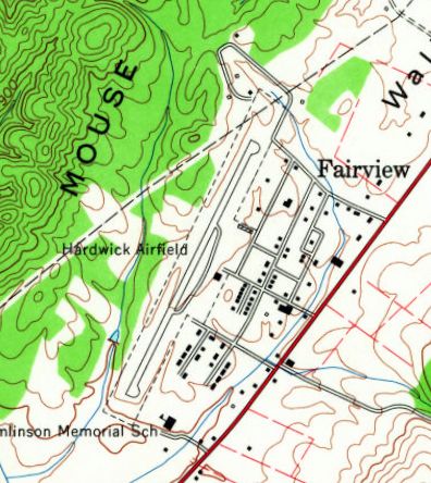
The 1965 USGS topo map depicted Hardwick Airfield as having a northeast/southwest runway.
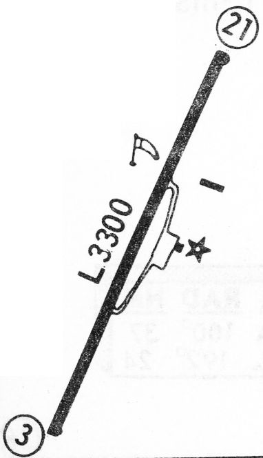
The 1968 Flight Guide (courtesy of Robert Levittan) depicted Hardwick Airfield as having a single 3,300' paved Runway 3/21,
with a taxiway leading to a ramp & 1 small building on the east side.

The last aeronautical chart depiction which has been located of Hardwick Field
was on the February 1968 Chattanooga Sectional Chart.
It depicted Hardwick as having a 3,300' paved northeast/southwest runway.
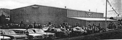
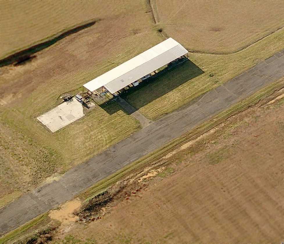
The earliest photo which has been located of Hardwick Field was a 1970 photo of a hangar during an open house.
Hardwick Field's FAA Airport/Facility Directory data said that it conducted an average of 100 takeoffs or landings per week in 2011.
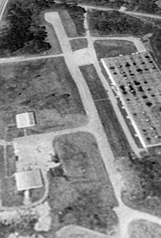
A 3/15/97 USGS aerial view looking southwest at Hardwick Field a paved Runway 3/21,
and 4 single-engine aircraft parked on the ramp near several hangars.
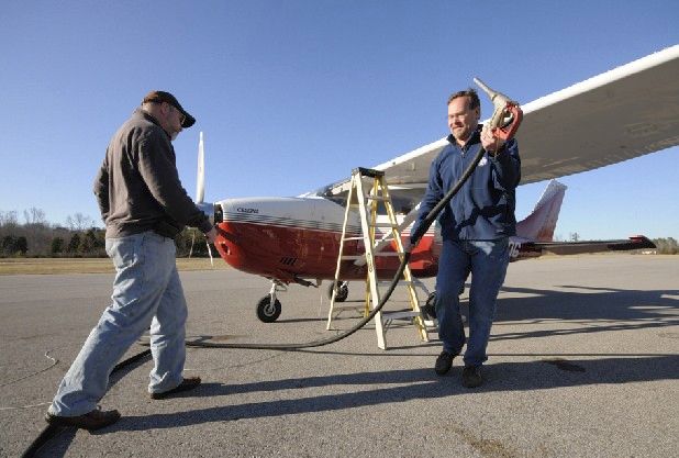
A January 2012 photo by Tim Barber of Cleveland Municipal Airport Manager David Harmon
fueling a Cessna for aerial survey photographer Fred Davis at Hardwick Field.
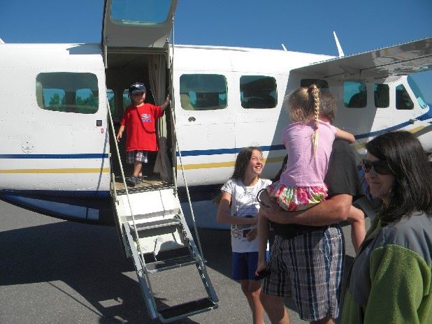
A June 2012 photo by Randall Higgins of Cole Newman, the 3-year-old son of Taylor Newman, the contract operator of Cleveland's Hardwick Field,
showing off a Cessna Caravan, one of the airplanes used for rides over town during an open house.
According to Wikipedia, “Cleveland Regional Jetport opened on 1/25/13 approximately 2 miles east of Hardwick Field.
It was created to replace Hardwick Field, which closed on 12/31/13.”
In 2014, Hardwick Field's FAA Airport/Facility Directory data described it as having a single 3,297' asphalt Runway 3/21, “in fair condition”.
The owner was listed as the City of Cleveland, and the manager was listed as David Harmon.
Hardwick was listed as having a total of 28 based aircraft.
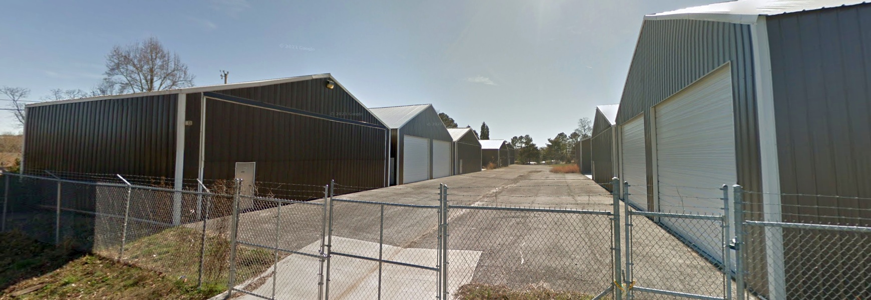
A 2017 photo looking south at rows of former Hardwick Field hangars.
A 2019 aerial view looking northwest depicted Hardwick Field as remaining intact.
Hardwick Field is located at the western terminus of Airport Road, appropriately enough.
Thanks to Don Warrington for pointing out the closure of this field.
____________________________________________________
Roane County Airport, Rockwood, TN
35.88, -84.62 (West of Knoxville, TN)
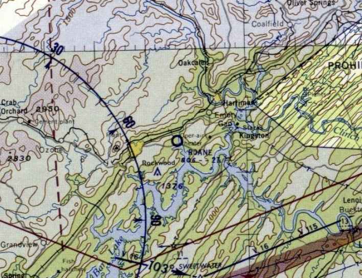
Roane County Airport, as depicted on the February 1958 Chattanooga Sectional Chart.
According to the book “The Aviation History of Tennessee” by Jim Fulbright (courtesy of David Stevenson),
“Construction of the Roane County Airport began in the early 1950s
when a 2,800' sod runway was built along Highway 70, two miles east of Rockwood.”
Roane County Airport was not yet depicted on the August 1957 Chattanooga Sectional Chart.
The earliest depiction which has been located of Roane County Airport was on the February 1958 Chattanooga Sectional Chart.
It depicted Roane as having a 2,700' unpaved runway.
According to the book “The Aviation History of Tennessee” by Jim Fulbright (courtesy of David Stevenson),
“By 1958 the runway was paved & 2 metal hangars with office & shop space were constructed.
Ray Brumley, a former U.S. Air Force pilot, began offering instruction & charter services.”
According to Keith Murchison, “My dad remembered the airport was active when he was in high school in the late 1950s.”
According to the book “The Aviation History of Tennessee” by Jim Fulbright (courtesy of David Stevenson),
“In 1960 Jack Bowman became airport manager.
A short time later the City of Rockwood received approval for scheduled airline service contingent on developing a new airport.”
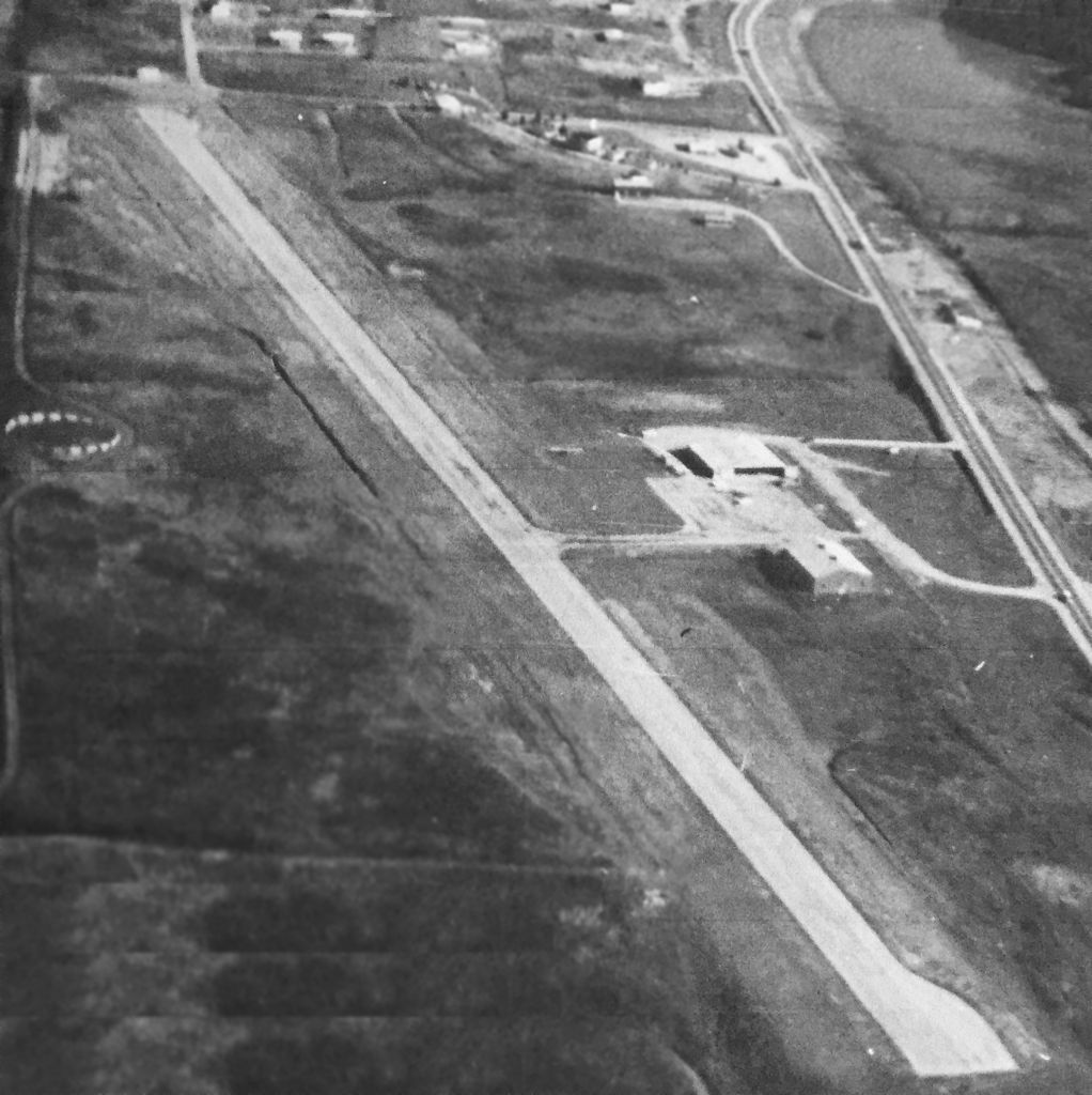
The earliest photo which has been located of Roane County Airport was a 1961 aerial view by David Stevenson, “while the airport was still active.”
It depicted 2 hangars on the south side of a paved east/west runway.
According to the book “The Aviation History of Tennessee” by Jim Fulbright (courtesy of David Stevenson),
“Roane County Airport was closed about 1962.”
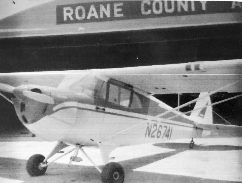
The only photo which has been located of an aircraft at Roane County Airport was a 8/24/63 photo by David Stevenson of his Piper J4A Cub “in front of the main hangar.”
David recalled, “I flew my airplane out on 8/24/63; the field was closed with Xs on the runway -
Rockwood officials had requested that the FAA enforce the closure,
and an FAA inspector was there – told us that we could depart but if we landed we would get a violation.”
Keith Murchison recalled, “My dad... said he tried to flight plan it in 1967 & it was closed.
In 1977 my dad & I would drive by the old airport.
It was closed & the Palm Beach Mill Factory Outlet was built along the runway.
The hangars were not in too bad of a condition.
The rodeo complex had not been built then, the community college was there but was very small at the time.”
A 3/15/97 USGS aerial view looking west along the site of Roane County Airport.
The earliest depiction which has been located of the Roane County Airport site was a 3/15/97 USGS aerial view.
It depicted 2 metal hangars on the south side of a paved runway,
and the factory outlet which had been built to the north of the runway.
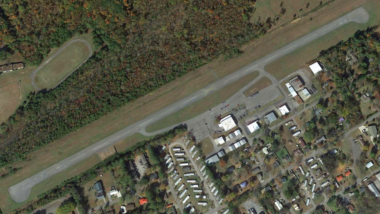
A circa 2010 aerial view looking east at the runway & hangars which remain at the site of Roane County Airport.
A 4/12/13 aerial view looking west at the runway & hangars which remain at the site of Roane County Airport.
A 2014 photo by Keith Murchison looking west along the remains of the Roane County Airport runway.
A 2014 photo by Keith Murchison looking southeast at a former Roane County Airport hangar.
A 2014 photo by Keith Murchison looking southwest at a former Roane County Airport hangar.
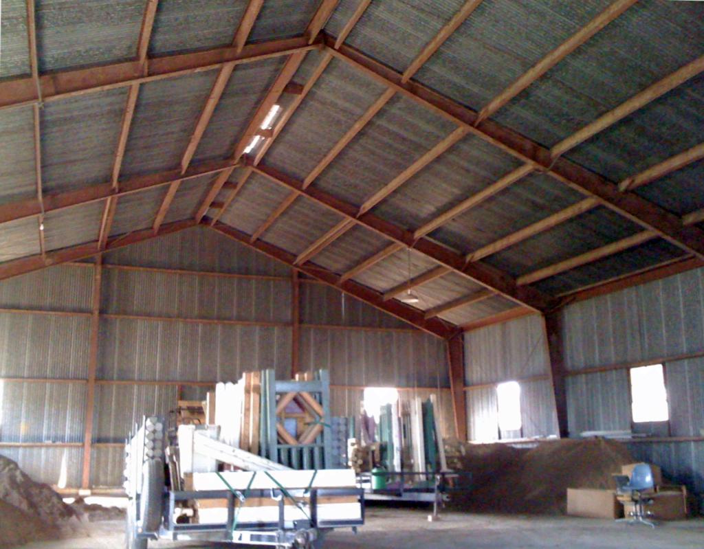
A 2014 photo by Keith Murchison of the interior of a former Roane County Airport hangar.
As of 2014, street maps labeled the airport site as part of Roane State Community College, and the former runway was labeled College School Drive.
____________________________________________________
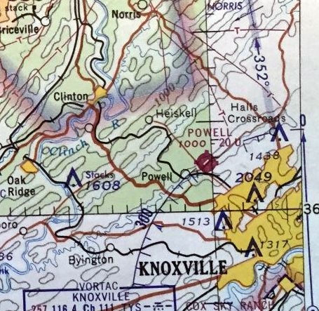
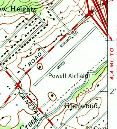
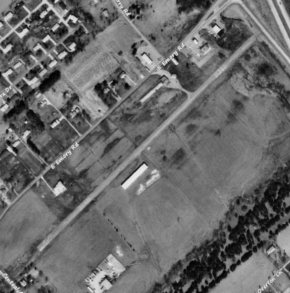
Powell Airport / Powell STOLPort (9A2), Powell, TN
36.044, -84.005 (Northwest of Knoxville, TN)
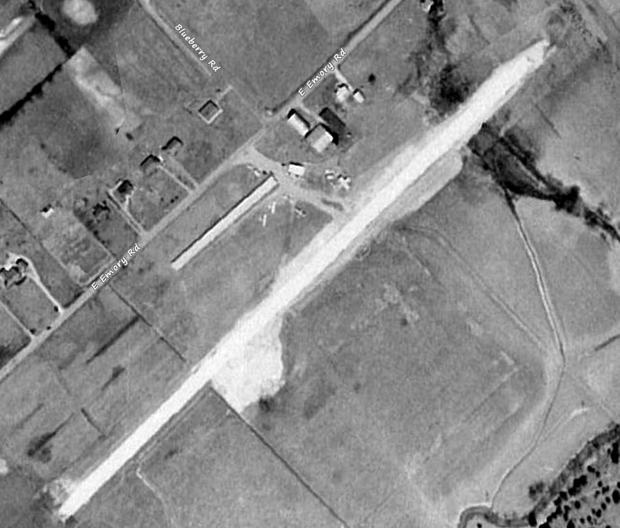
Powell Airport, as depicted on a 1959 aerial photo (courtesy of Jason McDaniel).
Powell Airport was not yet depicted on the 1945 Winston Salem Sectional Chart (courtesy of Dick Merrill).
According to the book “The Aviation History of Tennessee” by Jim Fulbright (courtesy of David Stevenson),
“Powell Airport originated from a pasture on the dairy farm of Norman & Ruth Mayes in 1951.
The couple had recently learned to fly & bought an Aeronca Champ.
As other flyers in the area began using the airstrip, Mayes made several improvements.
By 1957 a portion of the runway was paved & the airport was licensed for public use.”
The earliest depiction which has been located of Powell Airport was on a 1959 aerial photo (courtesy of Jason McDaniel).
It depicted Powell as having a single northeast/southwest runway,
with a few small buildings & 4 light single-engine planes on the northwest side.
Powell Airport was not yet depicted on the 1961 USGS topo map.
The earliest aeronautical chart depiction of Powell Airfield which has been located was on the on the January 1966 Nashville Sectional Chart (courtesy of David Stevenson).
It depicted Powell as having a single paved 2,000' runway.
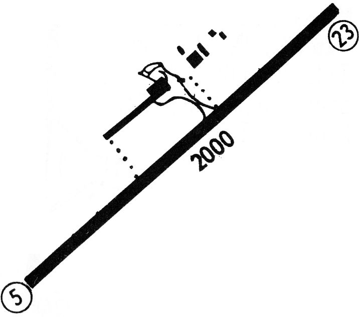
The 1968 Flight Guide (courtesy of Robert Levittan) depicted Powell as having a single paved 2,000' Runway 5/23,
with several small buildings on the northwest side.
A 1969 aerial photo (courtesy of Jason McDaniel) showed an Interstate being built adjacent to the northeast side of Powell Airport.
A building (a hangar?) had been added to the southeast side of the runway at some point between 1959-69.
Four light single-engine aircraft were parked near the buildings on the northwest side.
The 1970 USGS topo map depicted Powell Airfield as having a single paved northeast/southwest runway, with a few small buildings on either side.
A 1985 aerial photo (courtesy of Jason McDaniel) showed Powell Airport in an unchanged configuration compared to the 1969 photo.
No aircraft were visible on the field, but Jason McDaniel recalled this photo was “when I can remember seeing planes land & take off routinely as a kid.”
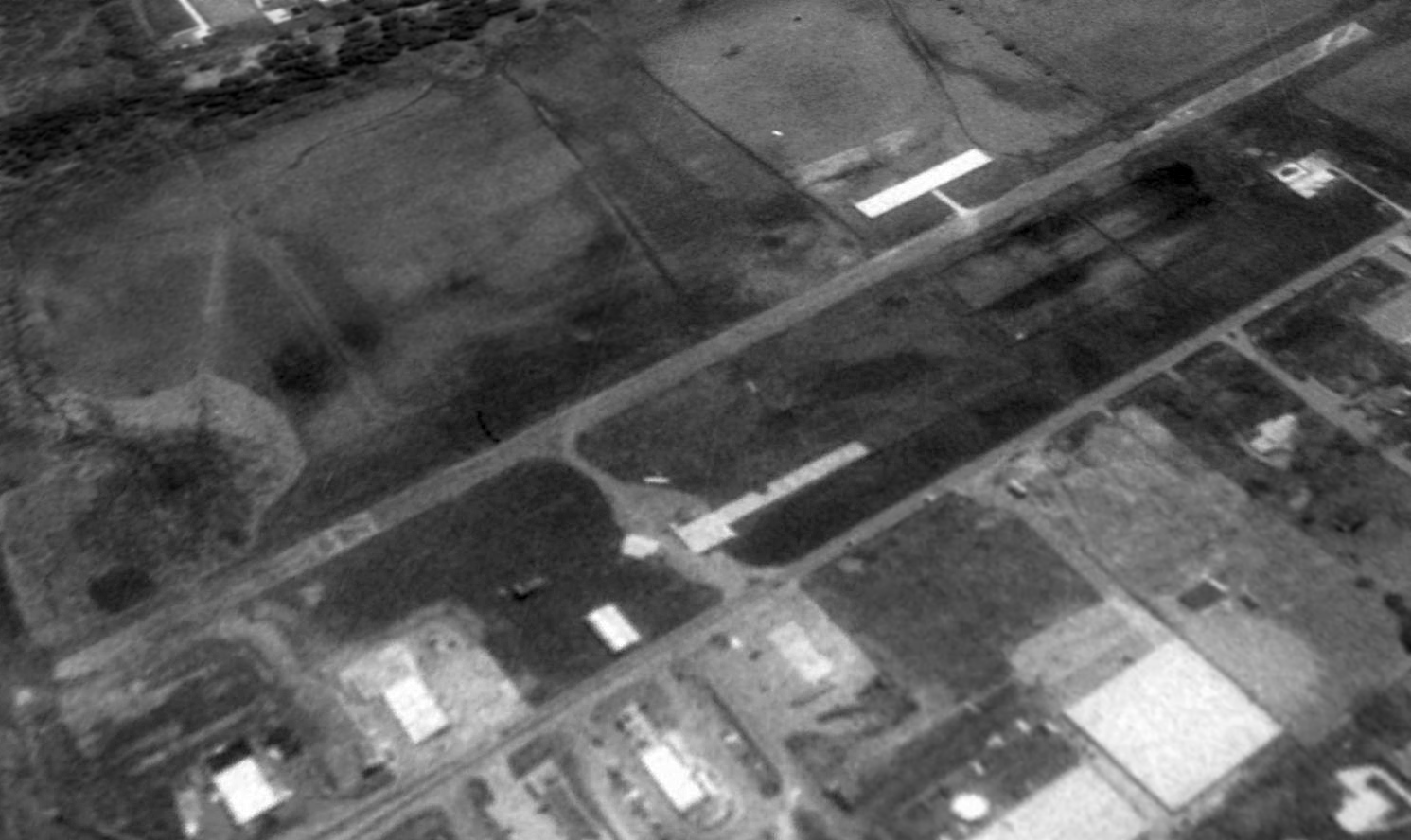
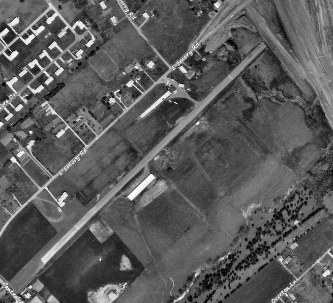
A 3/29/93 USGS aerial view looking south at the Powell STOLPort depicted 1 light single-engine aircraft parked off the northern ramp, near the center of the photo.
Powell STOLPort's runway numbers were still visible in a 1997 aerial photo, but had disappeared by the time of a 2002 aerial view.
A 3/5/03 aerial view showed the open-air parking shed on the south side remained intact.
A 12/20/03 aerial view showed that the northeast portion of the roof of the open-air parking shed on the south side had been removed,
exposing a Cessna parked within.
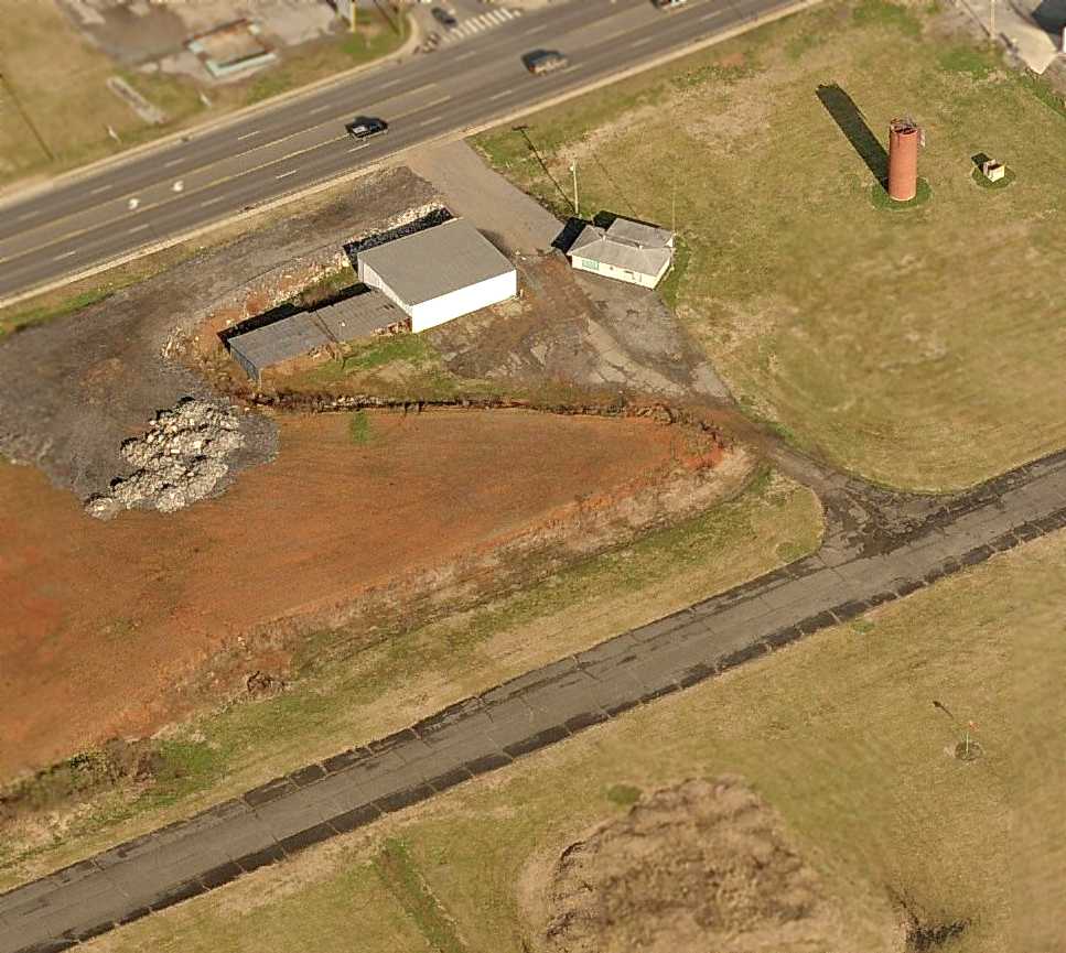
A circa 2003-2010 aerial view looking north at buildings on the north side of the Powell runway, including what looks like a hangar, an office, and a brick tower.
A circa 2003-2010 aerial view looking south at a parking shed on the south side of the Powell runway, under which appears to be the last aircraft on the property.
A 2006 aerial view looking north (courtesy of Jason McDaniel) showed 1 light single-engine plane remained visible at Powell Airport.
A 8/23/10 aerial view showed the open-air parking shed remained standing, and the runway had no visible markings.
According to its last FAA Airport/Facility Directory data, Powell STOLPort was a public-use airport having a single 2,600' asphalt Runway 5/23, in poor condition.
The owner & manager was listed as Norman Mayes,
and the airport was said to have 5 based aircraft: 4 single-engine & 1 multi-engine.
A 10/9/10 aerial view showed that the remainder of the parking shed on the south side had been removed,
and 2 large closed-runway X symbols had been painted on the runway.
A 2012 photo by Keith W. of Powell STOLPort.
Of the plane peeking out from the hangar, Keith reported, “There is some amphibious plane that has been parked for a while. ”
A 4/12/12 aerial view looking southwest shows Powell's runway to remain intact.
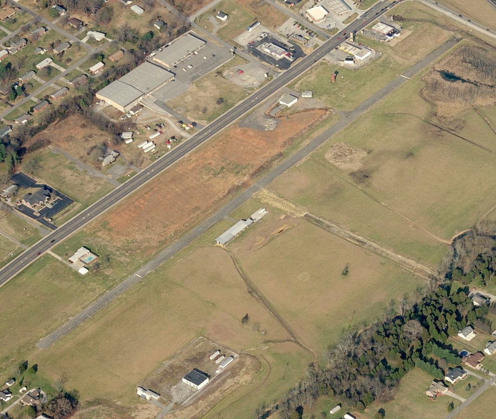
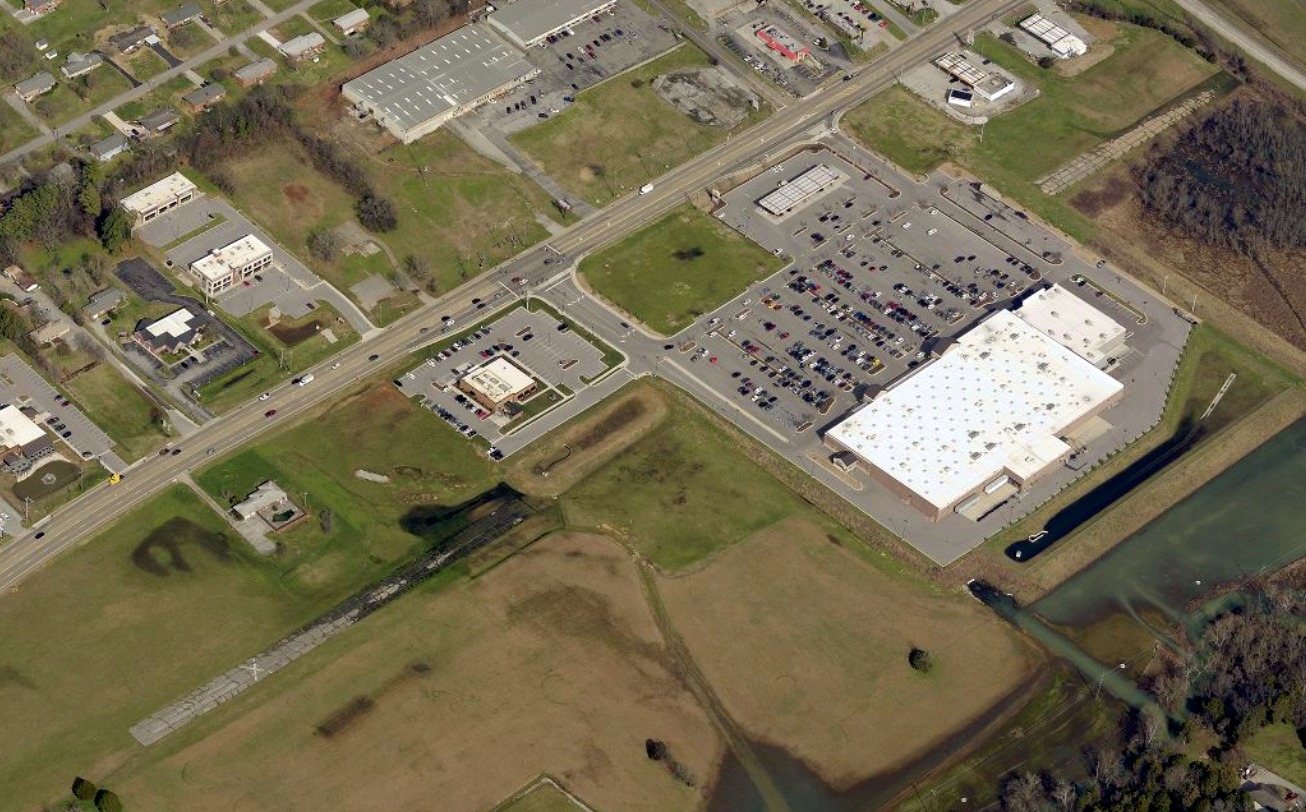
Ryan Peters reported, “Between 2014-2016 the Kroger store took over the east end of the runway.
In 2017 a restaurant was added near the roadway.”
Ryan Peters reported in 2018, “It appears that a strip mall has been built in its place.
The white garage building appears to be intact, and possibly the aircraft tie-downs.”
R. Cate reported in 2019, “Powell Airport... This no longer exists other than a very short stretch of the runway that wasn’t dug up.
It was sold & several businesses have been built on the property.
Not enough left to even make an emergency landing. There are more large stores going in soon & what’s left will be gone.”
A February 2020 aerial view looking north (courtesy of Jason McDaniel) showed that a large retail building was built over the center of the Powell Airport site,
but paved runway portions remained on both ends.
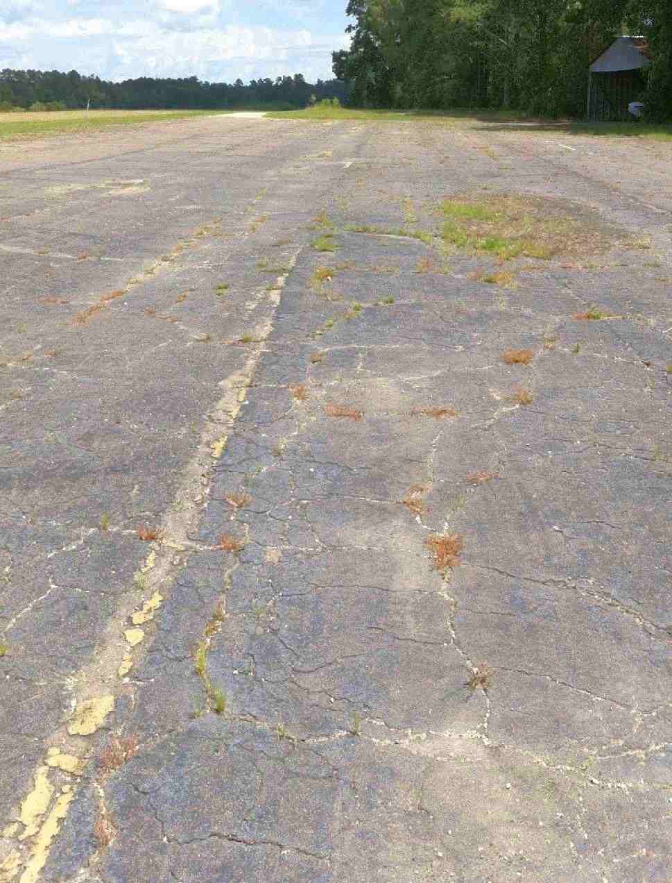
A 2022 photo looking southwest at the southwestern portion of the remains of the Powell Airport paved runway.
The site of Powell STOLPort is located southwest of the intersection of Interstate 75 & East Emory Road.
____________________________________________________
36.17, -82.75 (East of Nashville, TN)
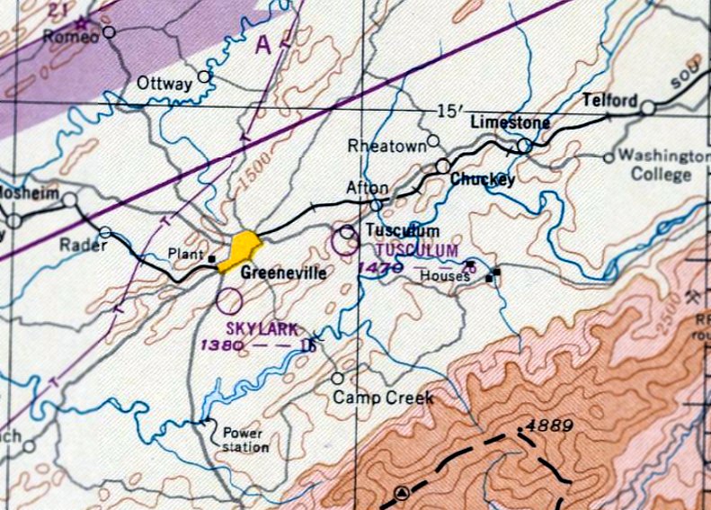
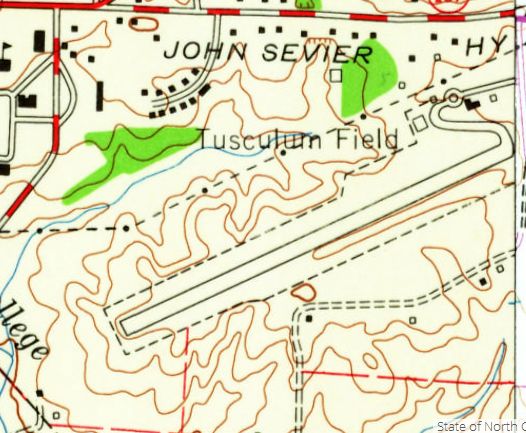
Tusculum Field, as depicted on the July 1949 Winston-Salem Sectional Chart.
No airfield was yet depicted at this location on the 1940 USGS topo map (courtesy of Dallam Oliver-Lee).
According to the book “The Aviation History of Tennessee” by Jim Fulbright (courtesy of David Stevenson),
“The first airport in Greene County was Tusculum Field.
It was opened in March 1948 with funding that was provided by both Greeneville & Greene County.
The first flight from the sod strip was made by Hunter Jones.”
Tusculum Field was not yet depicted on the October 1948 Winston-Salem Sectional Chart.
The earliest depiction of Tusculum Field which has been located was on the July 1948 Winston-Salem Sectional Chart.
It depicted Tusculum Field as having a 2,600' unpaved runway.
According to the book “The Aviation History of Tennessee” by Jim Fulbright (courtesy of David Stevenson),
“In 1953 an airport paving project was financed by 3 local firms:
The Austin Tobacco Company, Malone Brothers Construction Company, and Magnavox.”
The July 1954 Winston-Salem Sectional Chart (courtesy of Chris Kennedy) depicted Tusculum Field as having a 2,600' unpaved runway.
According to the book “The Aviation History of Tennessee” by Jim Fulbright (courtesy of David Stevenson),
“Plans to expand the airport were halted in 1957 when the federal government refused to provide funds, except for a new airport.”
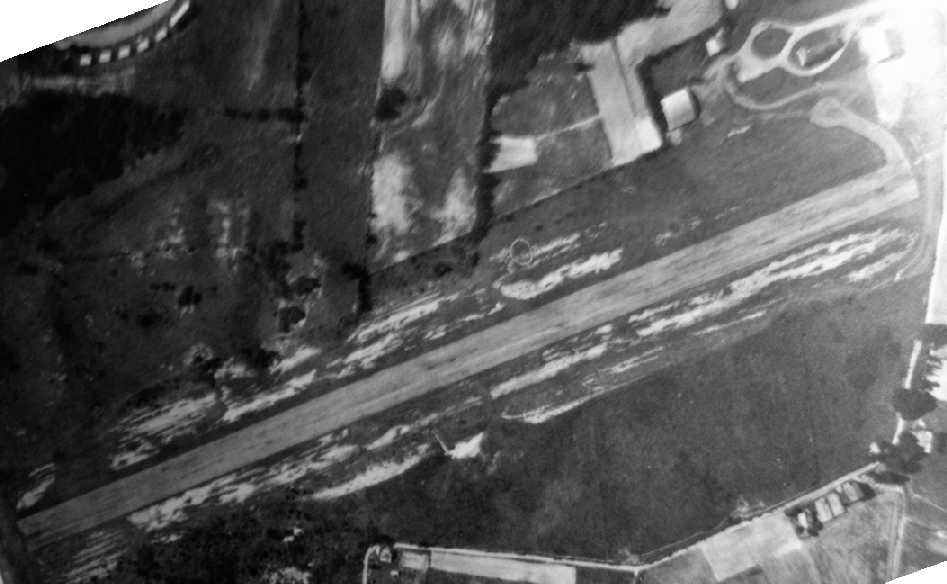
The only photo which has been located showing Tusculum Field while open was a June 1960 aerial view (courtesy of David Stevenson).
It depicted a single northeast/southwest paved runway, with a taxiway that led to a few small buildings on the northeast side of the field.
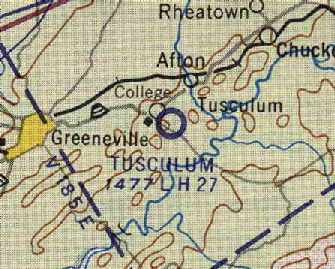
The July 1961 Winston-Salem Sectional Chart (courtesy of Chris Kennedy) depicted Tusculum as having a 2,700' hard-surface runway.
The 1961 USGS topo map depicted Tusculum Field as having a single paved northeast/southwest runway,
with a taxiway leading to a few small buildings on the northeast side of the field.
Tusculum Field's runway was somewhat lengthened at some point between 1961-67,
as the 1967 AOPA Airport Directory (courtesy of Chris Kennedy)
described Tusculum Field as having a single 5,000' asphalt Runway 5/23.
The field was said to offer fuel, repairs, hangars, and tiedowns.
According to the book “The Aviation History of Tennessee” by Jim Fulbright (courtesy of David Stevenson),
“Tusculum Field was closed in 1968 following the opening of the new Greeneville – Greene County Municipal Airport.”
Tusculum Field was no longer listed among active airfields in the 1971 Flight Guide (according to Chris Kennedy),
nor was is depicted on the 1980 USGS topo map (courtesy of Dallam Oliver-Lee).
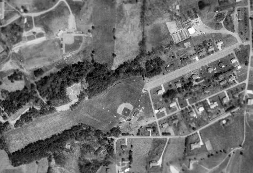
As seen in the 3/20/97 USGS aerial photo,
the eastern half of the former runway of Tusculum Field had been reused as a street, Pleasant View Drive.
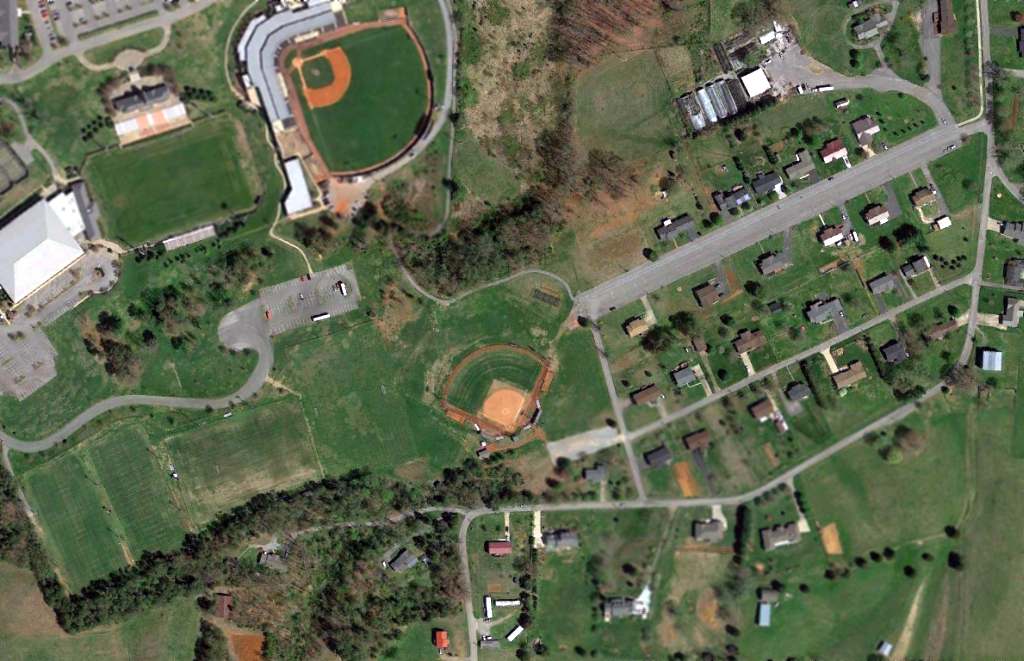
A baseball diamond had been constructed over the center of the former runway,
with the western half of the former runway having been removed, but its outline was still recognizable.
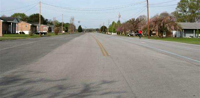
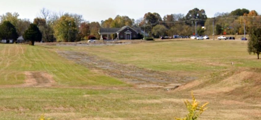
A 2008 photo by Dick Merrill looking to the southeast along the street which used to be the runway of Tusculum Airport.
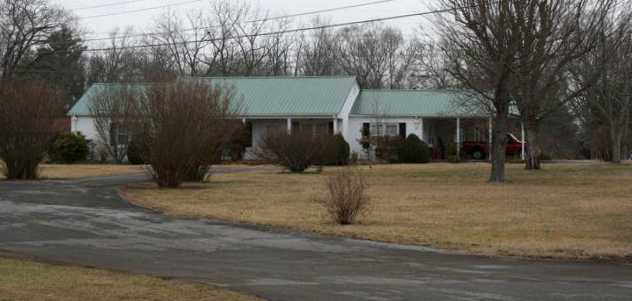
A 2009 photo by Dick Merrill of the house which used to be the Tusculum Airport office.
A 4/12/13 aerial view (courtesy of Dallam Oliver-Lee) shows the eastern half of Tusculum's runway remains intact, reused as a street.
The former hangar is just north of the runway segment.
A 2013 photo looking west at the former Tusculum Airport hangar.
The site of Tusculum Airport is located southwest of the intersection of Pleasant View Drive & Briar Patch Lane.
Thanks to Chris Kennedy for pointing out this airfield.
____________________________________________________
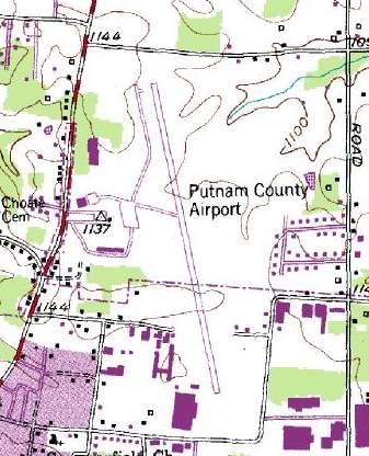
Cookeville Airport / Putnam County Airport (CJE), Cookeville, TN
36.194, -85.488 (East of Nashville, TN)
Cookeville Airport, as depicted on the September 1935 Nashville Sectional Chart.
According to the book “The Aviation History of Tennessee” by Jim Fulbright (courtesy of David Stevenson),
“It was in the fall of 1932 when Cookeville resident Clarence Stone noticed an airplane parked in a field about a mile southeast of town.
Stone, who had always wanted to fly, was curious about why the pilot & Waco 10 were there.
Stone introduced himself to Earl Stark of Elkhart, IN, a barnstormer who was enroute to FL.
Stone convinced Elkhart to stay in Cookeville for the winter & promised to help find a place from which to fly.
The next day, arrangements were made to rent a field north of town for $50/year.
This makeshift field became Cookeville Airport, one of the longest continually operated airports in TN.”
According to Angelo, the Cookeville Airport originally had 2 runways: a 2,600' East/West strip & a 1,200' North/South strip.
The earliest depiction which has been located of Cookeville Airport was on the September 1935 Nashville Sectional Chart.
It depicted Cookeville Airport as a commercial/municipal airport.
The April 1944 US Army/Navy Directory of Airfields (courtesy of Ken Mercer)
described Cookeville Airport as having a 2,700' unpaved runway.
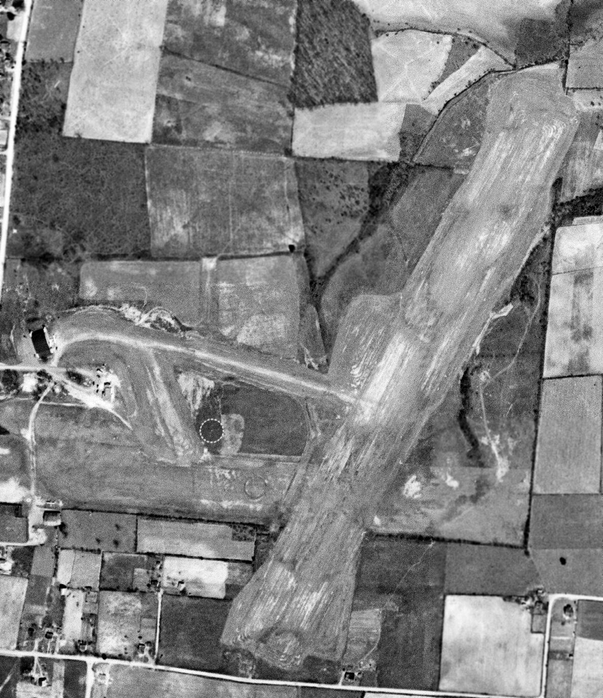
The earliest photo which has been located of Cookeville Putnam County Airport was a 4/7/50 USGS aerial photo.
It depicted Putnam County Airport as having 2 unpaved runways, with a taxiway leading to a hangar on the west side.

The 1953 USGS topo map depicted Putnam County Airport as having 2 unpaved runways, and a small building on the northwest side.
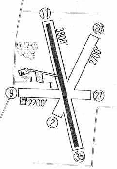
The Putnam County Airport had gained a paved runway at some point between 1953-60,
as the 1960 Jeppesen Airway Manual (courtesy of Chris Kennedy)
depicted the field as having a single 3,800' paved Runway 17/35,
as well as 2 unpaved runways: 2,700 Runway 2/20 & 2,200' Runway 9/27.
A taxiway led to a ramp on the west side of the field, with a single hangar.
The 1962 AOPA Airport Directory described the field as having
a 3,800' asphalt Runway 17/35 & a 1,500' turf Runway 9/27,
and listed the operator as Hunter's Flying Service.
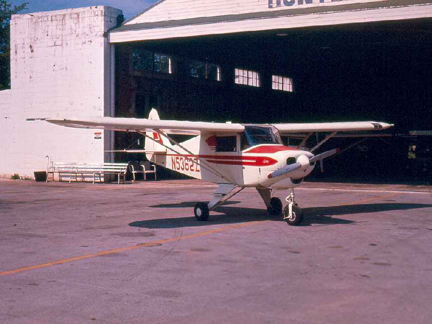
A 1964 photo by John O'Hara of a 108 hp Piper Colt in front of the Hunter's Flying Service hangar at Putnam County Airport.
John recalled, “I learned to fly in this plane. Mr. Hunter Mir owned & used this aircraft for his training & rental aircraft.
At that time, he also owned & operated a C-Model Bonanza. The airport was active in those days.
There were 11 aircraft based there & approximately a couple of dozen visiting aircraft per day.
Mr. Mir operated a flight school & charter service located in the lean-to portion of the hangar building.
At that time, the more modern building atop the hill was used as a restaurant.
There was an operating airport beacon light tower next to this building.”
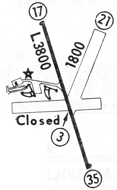
The 1968 Flight Guide (courtesy of Robert Levittan) depicted Putnam County Airport as having a single 3,300' paved Runway 17/35,
along with an 1,800' unpaved Runway 3/21 & a closed east/west runway.
A taxiway led to a ramp on the west side of the field, with a single hangar.
The July 1969 Nashville Sectional Chart depicted Putnam County Airport as having a single 3,800' paved northwest/southeast runway.
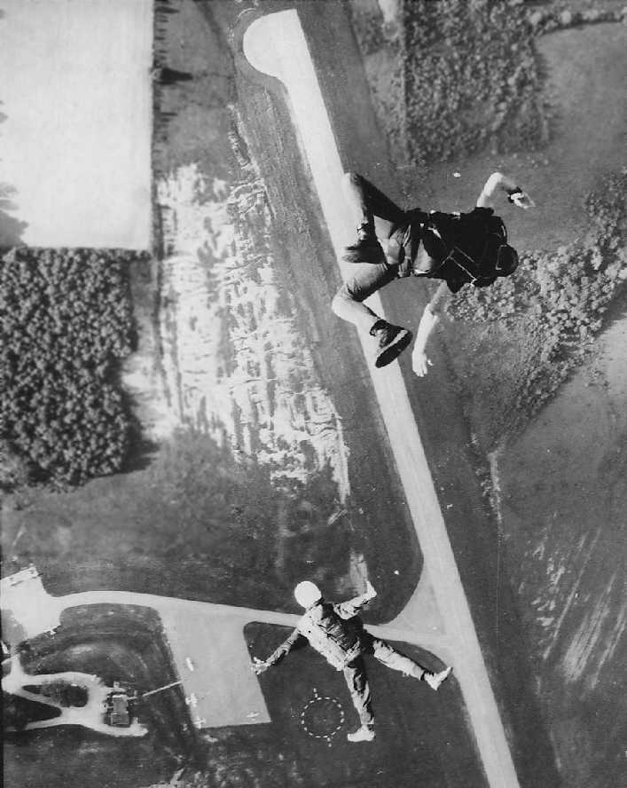
A 1975 photo by Tom Fleming of TTU skydivers with the Putnam County Airport visible below.
Tom recalled, “There was a very active skydiving group associated with the local university, Tennessee Tech, that utilized the airport in Cookeville for several years.
I took this photo in 1975 from approximately 4,000' AGL while at the same time piloting N2462G, a Cessna 182 owned by one of the members.
In the background you can see the airport & barely make out the runway numbers '17' on the right of the picture.
The jumper towards the lower-right is the Jumpmaster, Bruce Niles.
The large hangar is just off the top edge of this picture.”
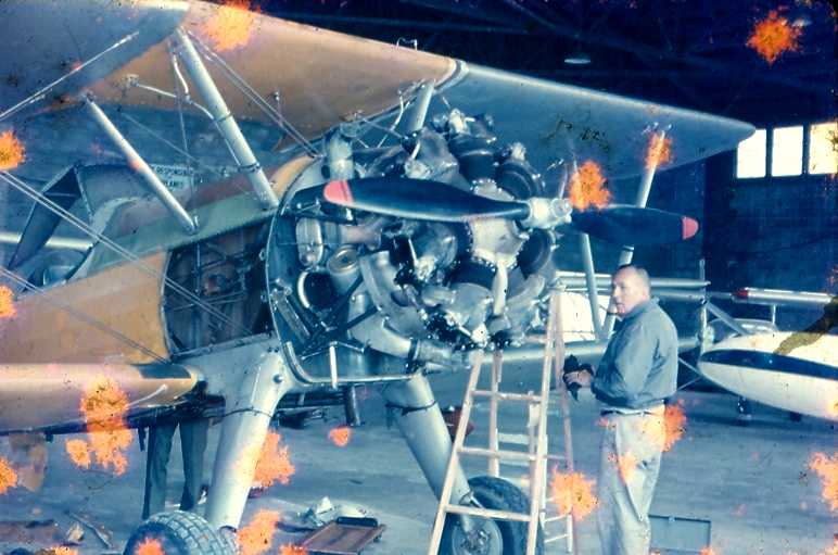
A circa 1979 photo by Tom Fleming “of Grady Allison restoring a Stearman, Boeing A75N1 in the hangar.
Grady worked for the National Guard & was the primary mechanic at the airport on his off-time for a long, long time.
I used to (1973–83) keep my plane in the large hangar at Putnam County Airport.”
In the 1982 AOPA Airport Directory (courtesy of Ed Drury) the runway configuration remained the same,
but the operator was listed as Skyways Inc.
By the time of the 1986 USGS topo map, apparently Putnam County Airport's crosswind grass runway had been closed.
Two paved taxiways led away from the paved runway toward a paved ramp in front of the hangar,
and another paved ramp in front of the terminal building.
Jason Duke recalled, “The Putnam County Airport... I first landed there in 1992 while getting my pilot’s license.
I even landed there the last night it was open. [It] closed in 1993.”
According to the book “The Aviation History of Tennessee” by Jim Fulbright (courtesy of David Stevenson),
“Expansion of the landing area was prohibited by lack of available property.
With airport growth thwarted, the city & county eventually opted for a plan to help develop a regional airport in nearby White County.
In 1993 the 61-year old Putnam County Airport was closed.”
Jason Duke recalled, “The current high school took 2 years to build & opened in the Fall of 1996.
It occupies the southern half of the old runway.”
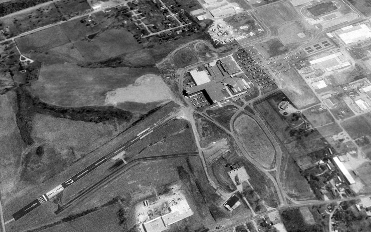
The new Cookeville High School was built over the southern portion of the Putnam County Airport site, as seen in a 1997 USGS aerial view looking southeast.
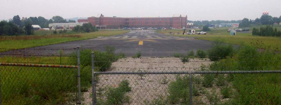
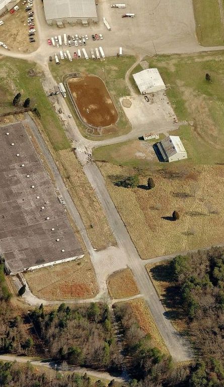
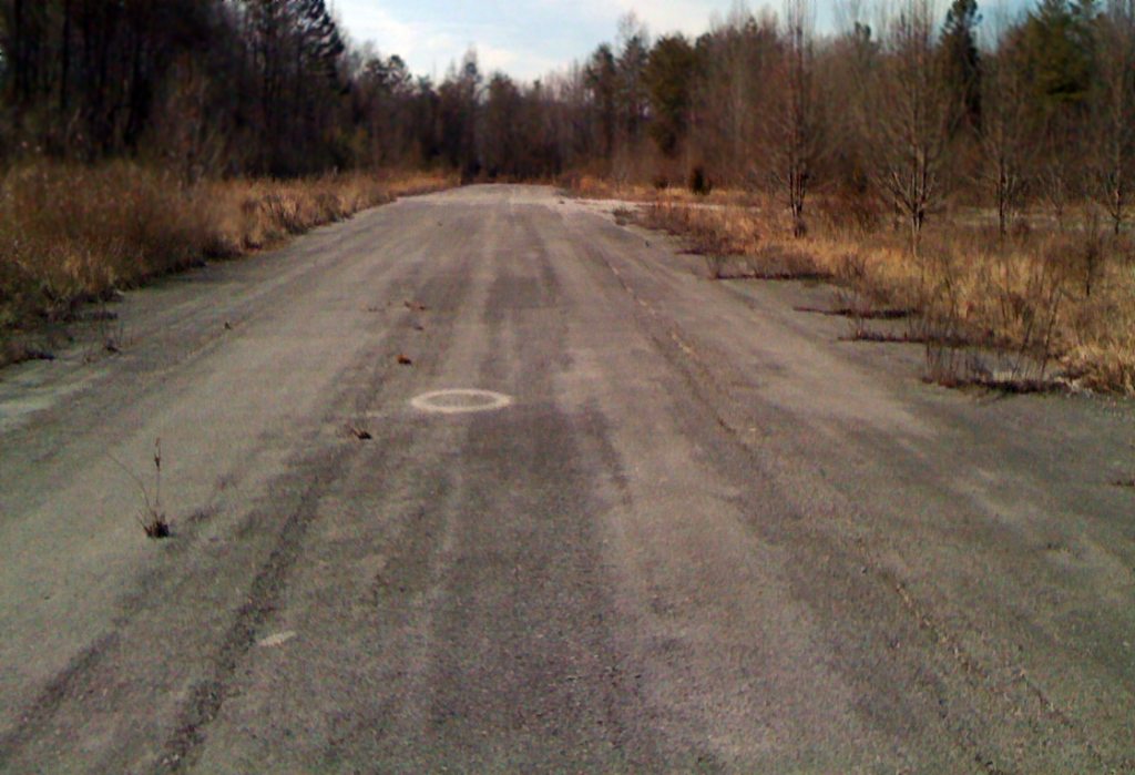
An 8/02 photo by Paul Freeman, looking south along the remaining 1,800' portion of the northern end of the former Runway 17,
toward the new Cookeville High School.
The remaining runway portion is used for operating model aircraft & go-carts.
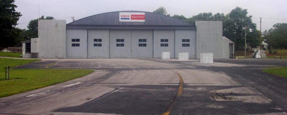
An 8/02 photo by Paul Freeman looking west at the former hangar of the Putnam County Airport.
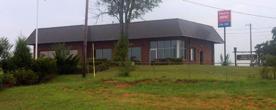
An 8/02 photo by Paul Freeman looking south at the former terminal building of the Putnam County Airport.
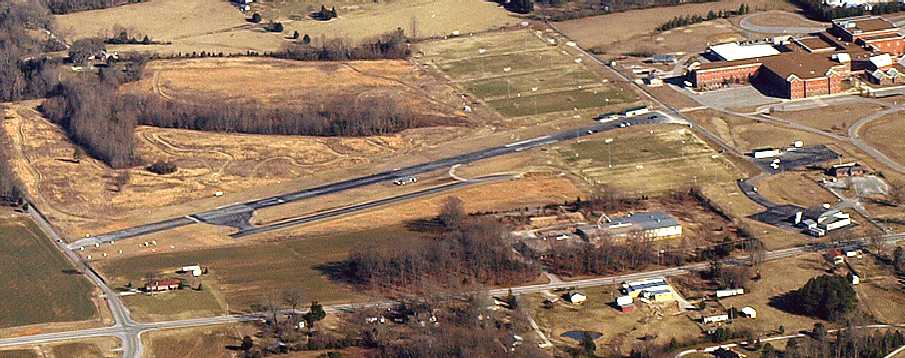
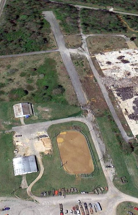
A 3/6/10 aerial view looking east at the northern end of Putnam County's Runway 17 which remains oddly intact.
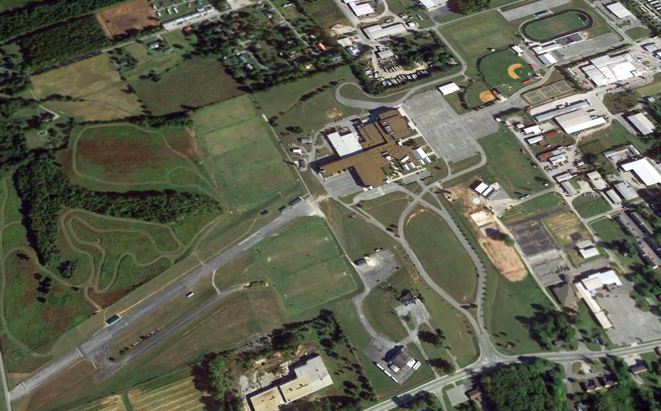
A 2013 aerial view looking southeast shows the northern end of Putnam County Airport's Runway 17 & a hangar remain oddly intact.
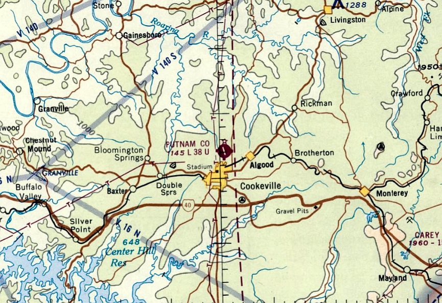
The site of Putnam County Airport is located southeast of the intersection of Route 136 & Whiteaker Springs Road.
Thanks to Marvin Maes for information about Putnam County Airport.
____________________________________________________
Or if you prefer to contact me directly concerning a contribution (for a mailing address to send a check),
please contact me at: paulandterryfreeman@gmail.com
If you enjoy this web site, please support it with a financial contribution.
____________________________________________________
This site covers airfields in all 50 states.