Abandoned & Little-Known Airfields:
Texas: Eastern Abilene area
© 2002, © 2026 by Paul Freeman. Revised 2/22/26.
This site covers airfields in all 50 states: Click here for the site's main menu.
____________________________________________________
Please consider a financial contribution to support the continued growth & operation of this site.
(Original) Abilene Municipal Airport (revised 9/20/16) - An Khe Army Stage Field / Walker Red Fox Airfield (revised 5/25/17) - Clear Lake Ranch (revised 9/6/21)
Da Nang Army Stage Field (revised 6/3/25) - Dempsey Army Heliport (revised 11/5/23) - Downing Army Heliport (revised 11/5/23) - Cam Ranh Army Stage Field (revised 6/3/25)
Camp Wolters / Fort Wolters Army Heliport (revised 2/22/26) - Fort Wolters Army Stage Field #1 / Pinto Stage Field (revised 6/3/25)
Fort Wolters Army Stage Field #2 / Sundance Stage Field (revised 5/25/17) - Fort Wolters Army Stage Field #3 / Ramrod Stage Field (revised 6/24/18)
Fort Wolters Army Stage Field #4 / Mustang Stage Field (revised 4/25/15) - Fort Wolters Stage Field #6 / Bronco Stage Field (revised 4/25/15) - Hue Stage Field (revised 11/5/23)
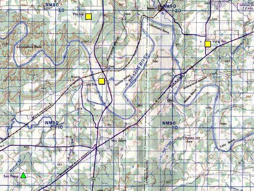
My Tho Army Stage Field (added 5/9/15) - Phu Loi Army Stage Field (added 5/4/15) - Qui Nhon Army Stage Field (revised 4/29/15) - Vung Tau Army Stage Field (revised 4/27/15)
____________________________________________________
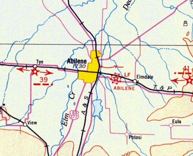
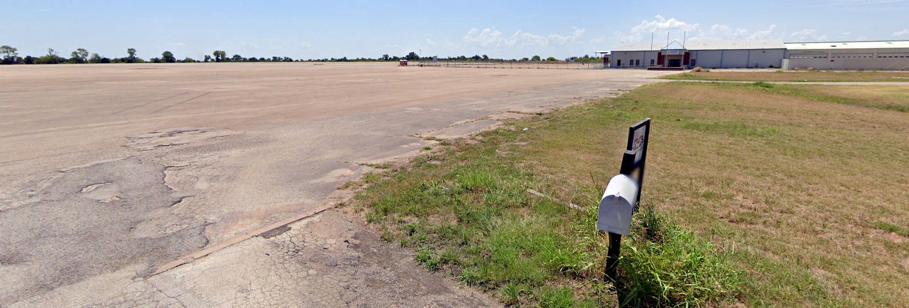
(Original) Abilene Municipal Airport, Abilene, TX
32.44, -99.69 West (West of Fort Worth, TX)
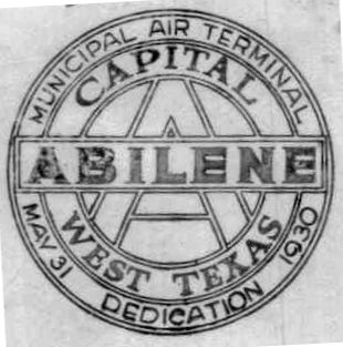
A postmark commemorated the 5/31/30 dedication of Abilene Municipal Air Terminal.
This former airfield is separate & distinct from the present-day Abilene Municipal Airport,
which sits on the opposite side of State Spur 322 to the southeast.
A postmark commemorated the 5/31/30 dedication of Abilene Municipal Air Terminal.
The earliest depiction which has been located of Abilene Air Terminal was on the 1932 Dallas Sectional Chart.
It depicted Abilene as a commercial/municipal airport.
The earliest directory listing which has been located of Abilene Air Terminal
was in the 1934 Department of Commerce Airfield Directory (according to Chris Kennedy).
It described the "Abilene Air Terminal" as having 3 sod runways,
with the longest being a 2,500' northwest/southeast strip.
An undated aerial view from The Airport Directory Company's 1937 Airports Directory (courtesy of Bob Rambo)
depicted Abilene Air Terminal as having 3 runways, with a single hangar & a terminal building alongside the ramp.
The Airport Directory Company's 1937 Airports Directory (courtesy of Bob Rambo)
described Abilene Air Terminal as having 3 gravel runways, with the longest being the 2,500' northwest/southeast strip.
The airport manager was listed as L.E. Derryberry,
and the operators were listed as American Airways Inc., C.J. Collier, L.E. Derryberry, and Paul Stambaugh.
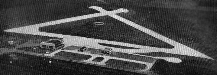
An undated aerial view looking west from The Airport Directory Company's 1938 Airports Directory (courtesy of David Brooks)
depicted Abilene Air Terminal as having 3 runways, a ramp & hangar along the south side.
The 1942 Dallas Sectional Chart (according to Chris Kennedy)
depicted "Abilene" as a commercial/municipal airport.
According to Scott Murdock, a March 1943 airfield directory listed this field as "Abilene Army Air Field (old)",
while a May 1943 directory listed the field as "Abilene Air Terminal".
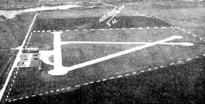
A 10/14/43 aerial view looking north from the 1945 AAF Airfield Directory (courtesy of Scott Murdock)
depicted Abilene Air Terminal as having 4 concrete runways with a ramp & hangar on the west side.
The 1945 AAF Airfield Directory (courtesy of Scott Murdock) described Abilene Air Terminal
as a 403 acre irregularly-shaped property having 4 concrete runways, the longest being a 3,640' northeast/southwest strip.
The field was said to have 2 hangars, the largest being a 185' x 120' wood structure,
and to be owned & operated by the City of Abilene.
At some point between 1943-54,
a much larger Abilene Municipal Airport was constructed on a separate plot of land one mile to the southeast.
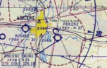
The August 1954 Dallas Sectional Chart (courtesy of Chris Kennedy)
depicted the original Abilene Airport (with a 3,700' hard surface runway),
as well as “Abilene (New)” adjacent to it on the south side (with a 5,400' hard surface runway).
Larry Nussbaumer recalled, “I attended an airshow at the NEW Municipal Airport,
probably in the summer of 1954.
Not long after that, Dad had me practice driving our (almost new then) 1953 Chevy
around the runways on the old Municipal Airport.
It certainly had to be before mid-summer 1955, as that's when Dad got a new 1955 Buick.”
The original Abilene Airport had evidently been abandoned by the time of an 11/11/54 USGS aerial view,
as the airport was devoid of any aircraft, but still completely intact.
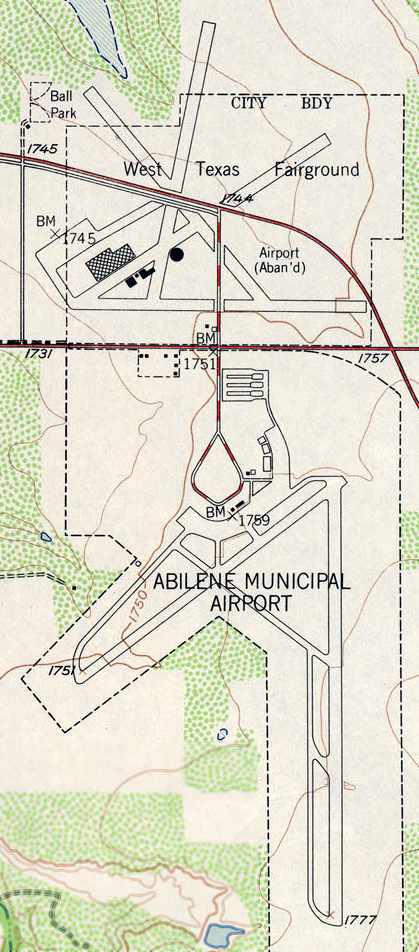
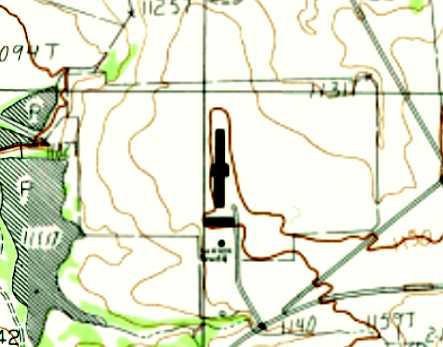
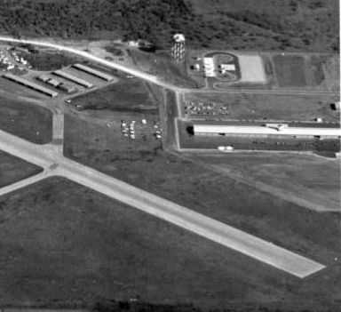
The 1957 USGS topo map depicted the runways of the original Abilene Municipal Airport
(at the top, labeled as “Airport Aban'd” & as the “West TX Fairground”)
and the newer & separate airfield layout of the present-day airport (at the bottom).
Only the new Abilene Municipal Airport was depicted on the March 1961 Austin Sectional Chart (courtesy of Chris Kennedy).
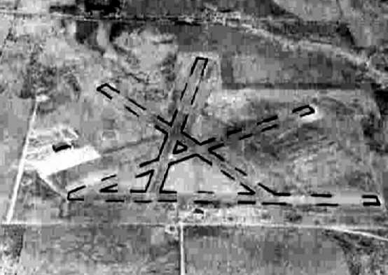
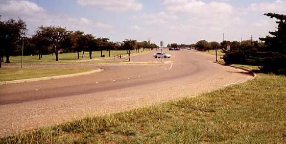
A 1967 aerial photo showed the remains of the runways of the original Abilene Airport, bisected by a new highway.

The 1987 USGS topo map, showing both the runways of the original Abilene Municipal Airport (at the top)
and the newer & separate airfield layout of the present-day airport (at the bottom).
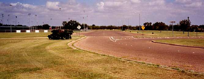
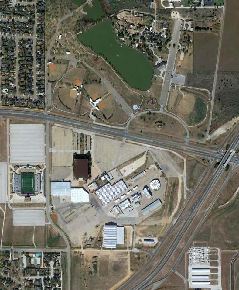
The City Coliseum was built at an unknown date on the western edge of the former ramp area.
The north end of a former runway has been reused as a parking lot of the Abilene Zoo,
and the northwest end of another former runway has been reused as a parking lot for ball fields next to the zoo.
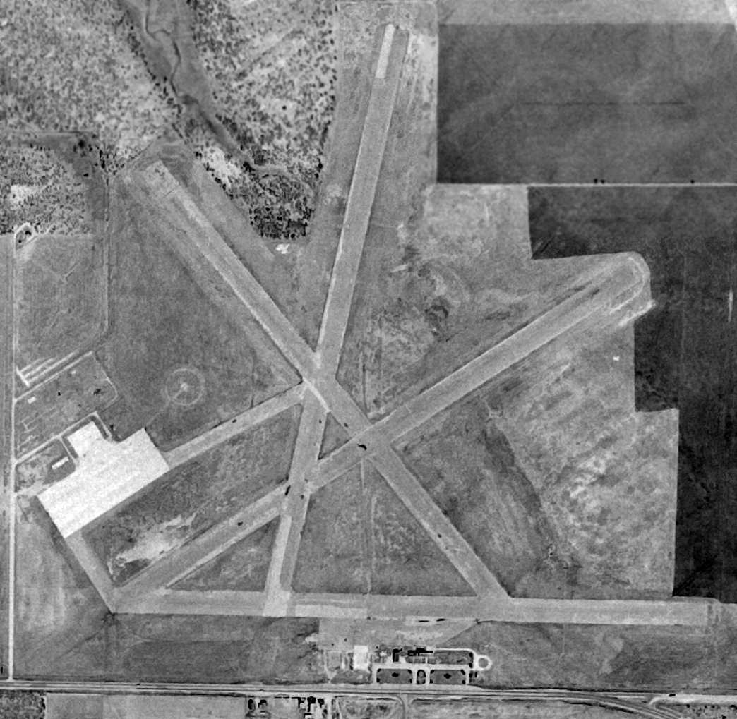
Significant portions of all 4 runways were still evident in the 1994 USGS aerial photo.
As seen in a 12/9/12 aerial photo, significant portions of all 4 runways of the original Abilene Municipal Airport were still evident.
It does not appear as if any of the original airfield buildings remain.
The site of the original Abilene Municipal Airport is located west of the intersection of State Spur 322 & Route 36.
Thanks to Scott Murdock for pointing out this former airfield.
____________________________________________________
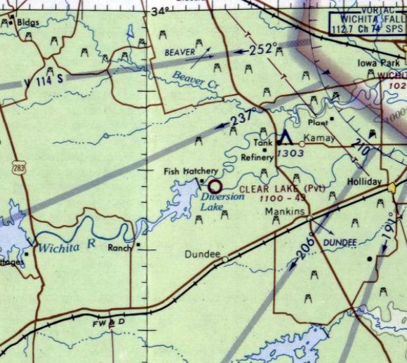
Clear Lake Ranch Airfield, Mankins, TX
33.82, -98.9 (Northwest of Fort Worth, TX)
Clear Lake Landing Strip, as depicted on the February 1966 Dallas Sectional Chart.
Photo of the airport while open has not been located.
Clear Lake Ranch Airfield was evidently constructed at some point between 1955-65,
as it was not yet depicted on a 1955 aerial photo or the July 1965 Dallas Sectional Chart.
The earliest depiction which has been located of the Clear Lake Airfield was on the February 1966 Dallas Sectional Chart.
It depicted Clear Lake as a private airfield having a 4,900' unpaved runway.
The earliest photo which has been located of Clear Lake Airfield was a 1965 aerial photo.
It depicted Clear Lake as having a single unpaved northeast/southwest runway, but there were no other facilities or aircraft visible.
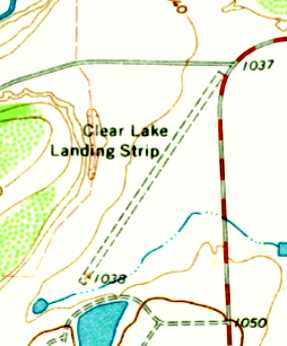
The 1966 USGS topo map depicted Clear Lake Landing Strip as having a single unpaved northeast/southwest runway.
![]()
The July 1968 Dallas Sectional Chart (courtesy of Chris Kennedy)
depicted Clear Lake Ranch as a private airfield with a single 3,100' paved runway.
The Clear Lake Ranch Airfield was evidently closed (for reasons unknown) at some point between 1968-78,
as it was depicted as an abandoned airfield on the 1978 DFW Sectional Chart (courtesy of Ray Brindle).
It was still labeled "Clear Lake Landing Strip" on the 1979 USGS topo map,
but was labeled simply "Landing Strip" on the 1983 USGS topo map.
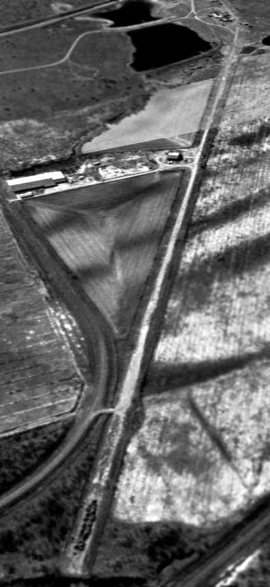
A 12/18/94 USGS aerial view looking southwest showed Clear Lake Ranch to have a single 3,600' paved runway,
along with a single hangar along the east side of the runway.
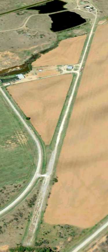
A 3/31/08 aerial view looking southwest showed the Clear Lake Ranch airfield remained largely unchanged.
Clear Lake Ranch Airfield is located west of the intersection of Ranch Road 1180 & Ranch Road 2846.
____________________________________________________
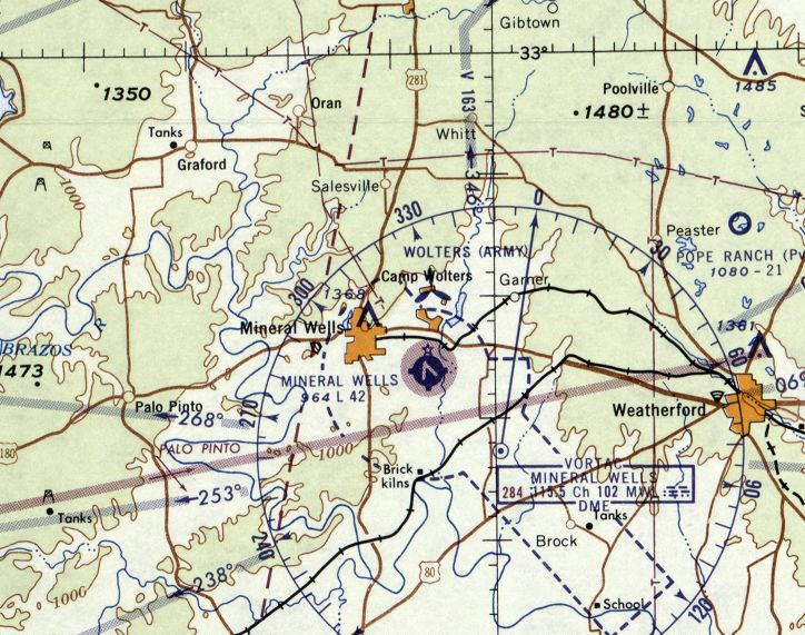
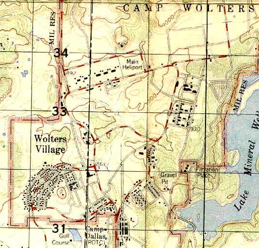
Camp Wolters / Fort Wolters Army Heliport (88TS), Mineral Wells, TX
32.84, -98.05 (West of Fort Worth, TX)
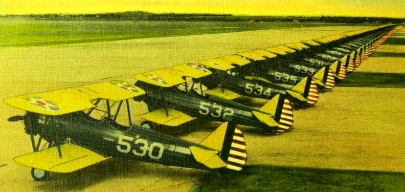
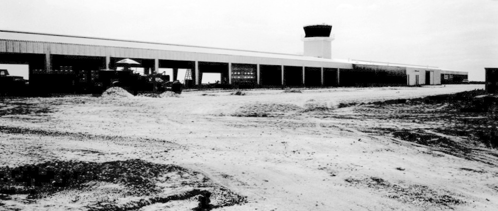
A WW2 era photo of a long line of biplane trainers on a paved ramp at Camp Wolters.
In 1925 a grant for construction of a Texas National Guard training camp was given to Brigadier General Jacob Wolters,
who established as Camp Wolters.
According to a 1999 historic sign, “On 10/13/40, the U.S. Army activated Camp Wolters as an infantry replacement center,
with the support of Mineral Wells community leaders.
Additional lands were bought or donated to the Army by local residents to expand the camp to over 7,500 acres.
In less than 4 months, more than 100 buildings were constructed.”
A 1943 Army Corps of Engineers photo of Camp Wolters
depicted a large rectangular concrete pad which evidently served as a foundation for numerous buildings (but would later become the massive heliport).
However, what appears to possibly have been a single runway (approximately 3,000' long)
extended away to the northwest from the concrete pad.
Camp Wolters was deactivated in 1945 & converted to private use.
No airfield at Camp Wolters was depicted on the September 1945, March 1946, or February 1950 Dallas Sectional Charts.
The facility was reactivated as Wolters Air Force Base (a non-flying base) in 1951.
It was used to house the newly formed Aviation Engineer Force,
which trained special-category Army & Air Force personnel.
These Air Force Aviation Engineer units may have constructed a paved runway,
1.5 miles northeast of what would eventually be the Fort Wolters Heliport.
This runway was apparently used for the Engineer's training purposes,
and not ever used for actual flying purposes.
This abandoned runway was later described as "completely weed infested"
by Chris Ness (who eventually attended helicopter training at Fort Wolters in the 1960s).
He recalled, "My only real memory was racing down it backwards in my car to adjust the brakes."
A 3/31/53 USGS aerial view depicted a large rectangular concrete pad which evidently served as a foundation for numerous buildings (but would later become the massive heliport) at Fort Wolters.
According to Fort Wolters History by Willie Casper, “On 7/1/56, Wolters Air Force Base
was reverted back to Army control with a dedication ceremony on 7/13/56.
Its mission was to prepare Camp Wolters to become the Primary Cargo Helicopter training base for pilots.”
A contract was awarded to the Southern Airways Company to conduct flight training
as the U.S. Army Primary Helicopter School.
The 1st class graduated from the U.S. Army Primary Helicopter School on 4/27/57.
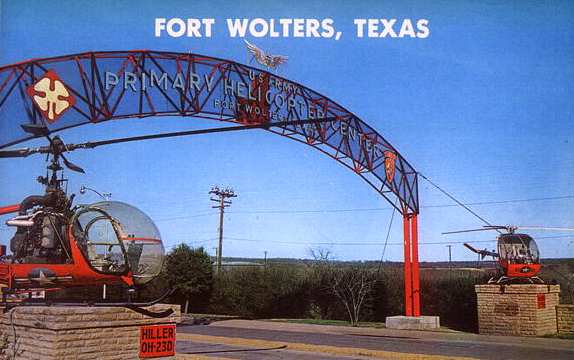
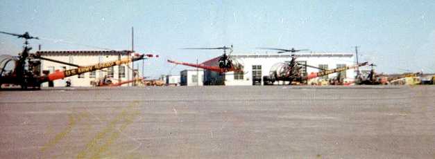
An undated view of a Hiller OH-23 & a Hughes TH-55 flanking the main entrance to Fort Wolters (courtesy of Steve Cruse).
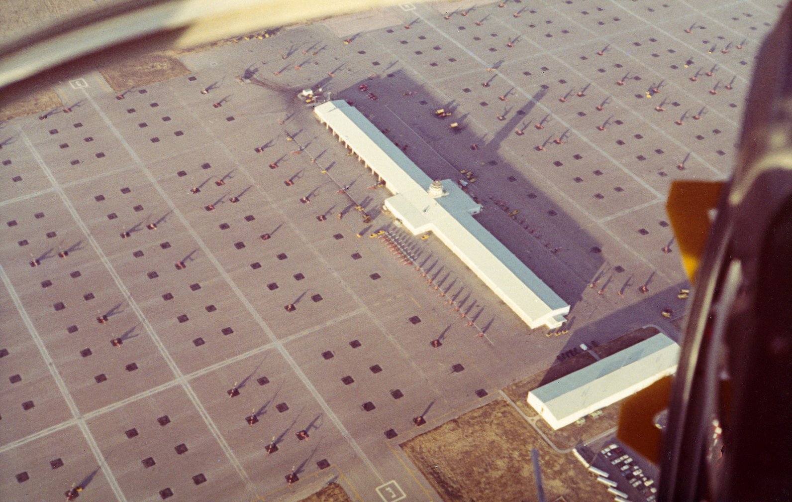
For their large-scale helicopter flight training operations at Fort Wolters,
in the area formerly occupied by the cantonment area
the Army constructed a large concrete helipad (approximately 4,300' x 1,200'),
with a control tower, and numerous other support buildings.
According to Chris Ness, a runway "was painted diagonally across the main heliport."
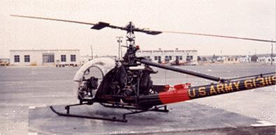
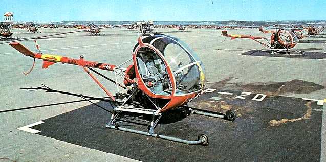
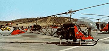
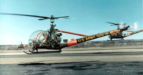
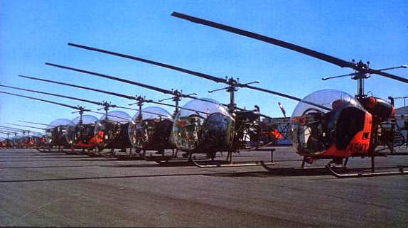
A Fort Wolters Hiller OH-23 Raven.
The School started with 125 Hiller OH-23 Raven helicopters.
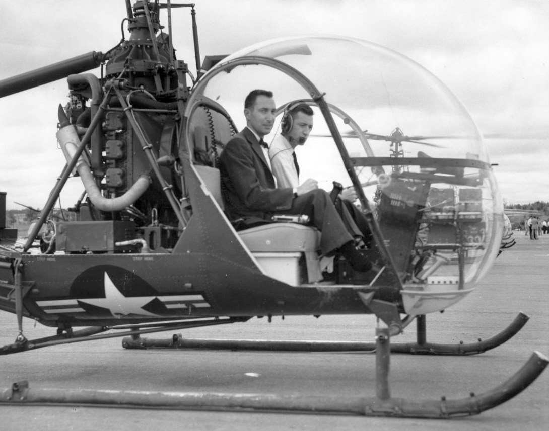
A 4/27/57 photo of Stanley Hiller, President of Hiller Helicopter Inc. arriving at Camp Wolters in a Hiller OH-23 Raven
for the ceremonies honoring the 1st graduating class of the U.S. Army Helicopter School.
No airfield at Camp Wolters was depicted on the September 1957 Dallas Sectional Chart.
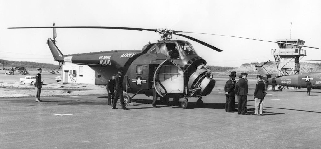
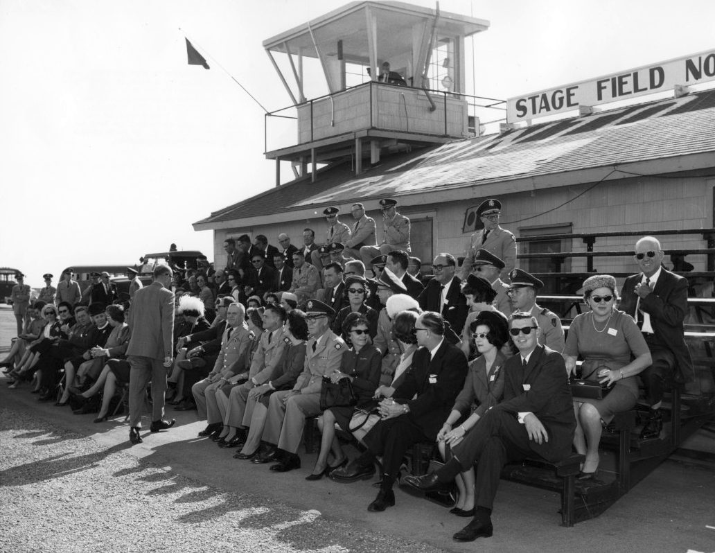
A 12/13/57 photo of touring TCU ROTC cadets looking over an Army H-19 helicopter, one of 5 types of Army aircraft on display at Fort Wolters.
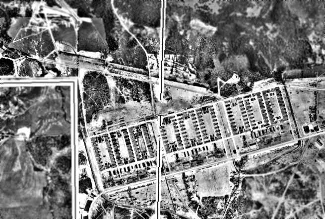
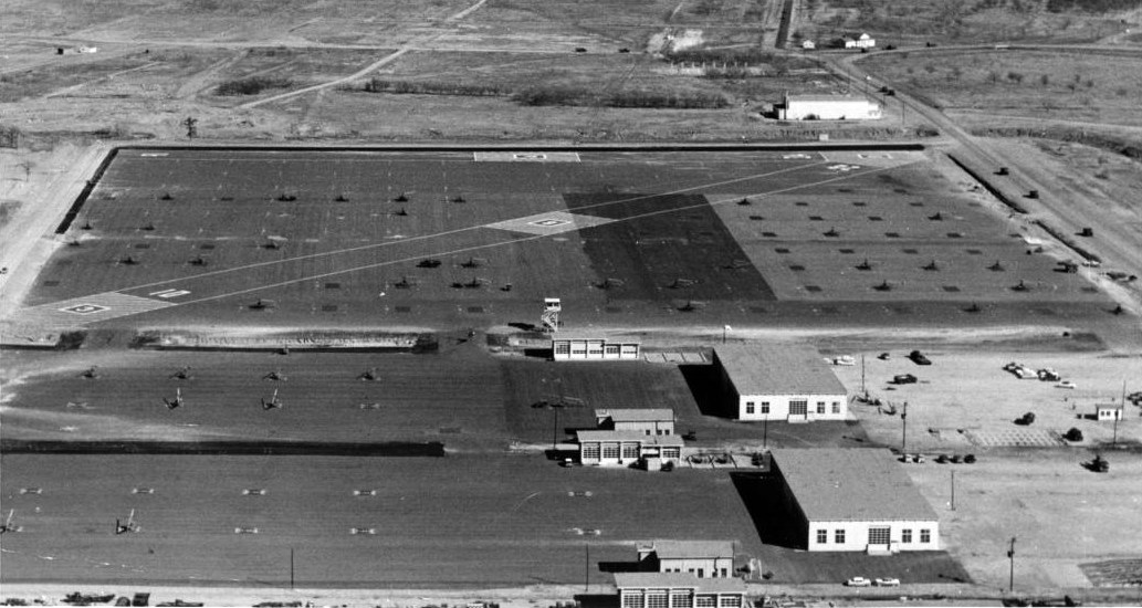
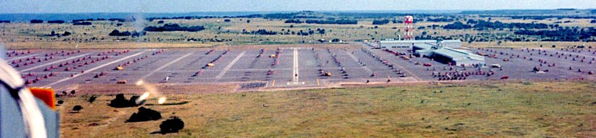
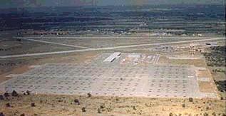
A 1/21/58 USGS aerial view depicted a large number of helicopter landing spots which had been laid out over the eastern portion of the massive Ft. Wolters concrete ramp.
The earliest aeronautical chart depiction which has been located of the Wolters Heliport was on the March 1958 Dallas Sectional Chart.
It depicted “Wolters AHP” with a rotor symbol.
A circa late 1950s aerial view looking at Fort Wolters, showing 2 runways painted on the east end of the heliport.

A January 1959 photo of the Nike surface-to-air missile Launch Site DF-70 while still under construction.
The Ft. Wolters property was also the site of an Army Nike surface-to-air missile battery, located just north of the helipad.
Site DF-70, consisting of both launcher & control sites, was constructed starting in 1959 & became operational in September 1960,
and was one of the 4 Nike batteries which protected the Dallas / Fort Worth metro area.
The August 1960 Dallas Sectional Chart depicted “Wolters (Army)” with a rotor symbol.
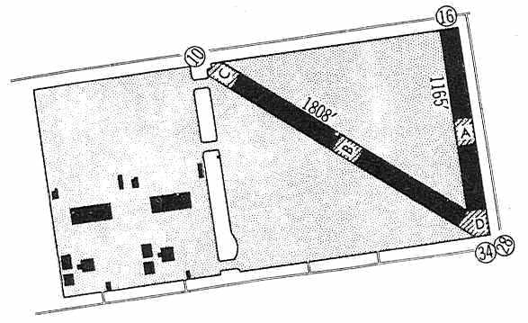
A 1960 Jeppesen Manual (courtesy of Chris Kennedy) depicted the Fort Wolters Army Heliport
as consisting of a 3,000' x 1,500' rectangular pad,
on the east side of which were 2 paved runways: 1,808' Runway 10/28 & 1,165' Runway 16/34.
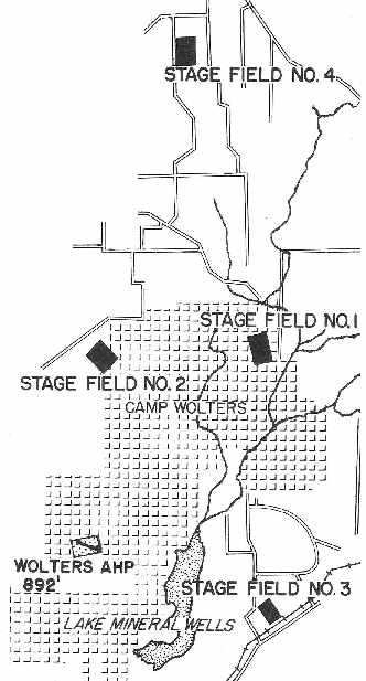
A 1960 Jeppesen Manual (courtesy of Chris Kennedy) depicted Fort Wolters as having 4 active Stage Fields,
outlying heliports constructed to handle the huge quantity of Fort Wolters flight training operations.
According to the 8/22/60 Mineral Wells Index, “The last formation flight of H-23D helicopters
to be delivered from Hiller Aircraft Corporation in Palo Alto CA for use at the U.S. Army Primary Helicopter School at Camp Wolters
touched down at the Wolters Main Heliport late Sunday afternoon after completing an 1,800 mile flight,
bringing the total complement of H-23Ds up to 144.”
On 6/1/63, Camp Wolters was redesignated Fort Wolters, a permanent military installation.
At the time all Army rotary-wing aviators received basic & primary flight training there.
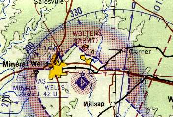
Ft Wolters Army Heliport, as depicted on the 1965 Dallas Sectional Chart (courtesy of John Voss).
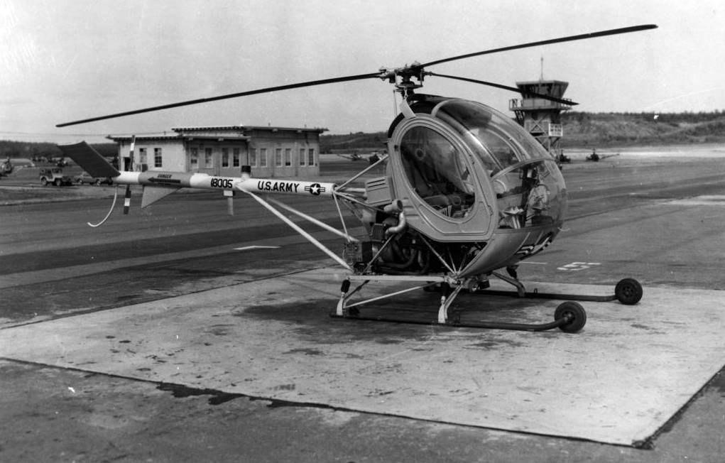
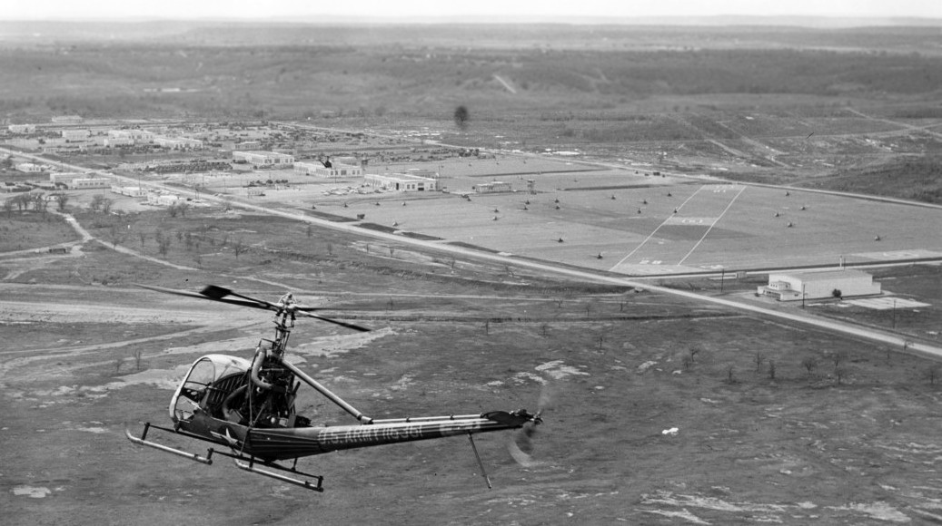
A 3/10/65 U.S. Army photo by Jack Cameron of a Hughes TH-55A Osage training helicopter at the main Fort Wolters heliport.
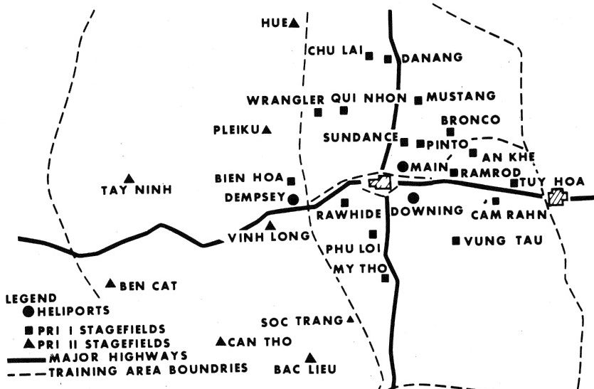
Early in the Vietnam War era,
helicopter training facilities at Fort Wolters were supplemented by 3 "Stage Fields" (small outlying heliports):
designated as Stage Field #1, Stage Field #2, and Stage Field #3.
According to a 1999 historic sign, “Camp Wolters was used for helicopter flight training with more than 1,000 helicopters stationed at 3 different heliports.
The base was expanded to cover nearly 722,000 acres of land for flight training purposes.”
In March 1966 the post was designated the U.S. Army Primary Helicopter Center.
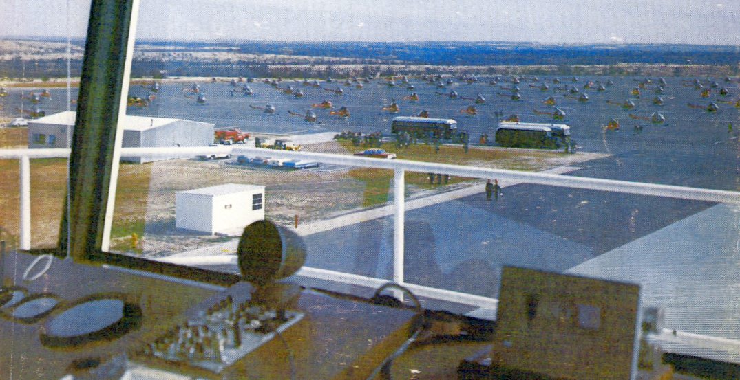
A 1966 Army photo from the Fort Wolters control tower in 1966,
showing a total of 80 OH-23 &TH-55 helicopters (courtesy of Chris Ness).
A January 1966 US Army Corps of Engineers aerial photo of the Ft. Wolters Nike-Hercules missile battery.
The Launch Site is on the left, and the Integrated Fire Control Site is on the right.
Fort Wolters, as depicted on the July 1966 USGS topo map (courtesy of Chris Ness).
A 11/22/66 photo of 6 OH-23D Ravens at Fort Wolters.
An undated aerial view looking northwest at a Hiller H-23 Raven approaching Fort Wolters.
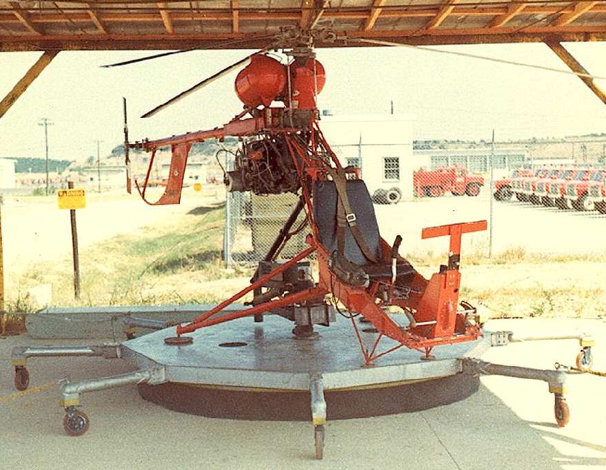
A 1966 photo by Chuck Ross of a truly unique machine - a Del Mar DH-1A Whirlymite, seen at Fort Wolters.
Perhaps the smallest manned aircraft the Army ever operated was the DH-1A Whirlymite,
a product of the Del Mar Engineering Labs.
A rare example of the Whirlymite was used at Fort Wolters by students needing additional hover practice.
It was tethered to a rolling platform, which itself was tethered to the corner posts of the shed.
In other uses the Whirlymite was flown as a conventional helicopter, in free, untethered flight.
In Chuck Ross' words, "I took that photo in August 1966 while attending pre-flight training at Fort Wolters.
I don't know how long the Whirlymite was there but gathered that it had been a year or so when I saw it.
My 'rotorhead' friends told me it was not part of the regular syllabus
but if a student needed hover practice beyond the syllabus hours it was cheaper & safer than an OH-23 or TH-55."
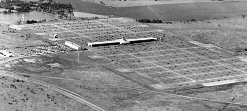
A pre-1967 aerial view looking west at the Fort Wolters Heliport (courtesy of Chris Ness).
As the volume of helicopter training at Fort Wolters picked up toward the latter stages of the Vietnam conflict,
the number of other nearby heliports used to support the heavy volume of flight training increased to an amazing 38.
The most elaborate were 2 large Army heliports: Downing Army Heliport & Dempsey Army Heliport.
Somewhat smaller “Stage Fields” were constructed in large numbers, of both “Type 1” & “Type 2”.
The first 7 Stage Fields were given "Western" names,
while the rest were named after towns in Vietnam to get the students used to Vietnamese names.
Type 1 Stage Fields were: An Khe, Bronco (Stagefield 6), Cam Ranh, Chu Lai, Da Nang, Mustang (Stagefield 4), My Tho, Phu Loi, Pinto (Stagefield 1),
Qui Nhon, Ramrod (Stagefield 3), Rawhide (Stagefield 5), Sundance (Stagefield 2), Tuy Hoa, Vung Tau, and Wrangler (Stagefield 7).
Type 2 Stage Fields were: Bac Lieu, Ben Cat, Ben Hoa, Can Tho, Hue, Pleiku, Soc Trang, Tay Ninh, and Ving Long.
A number of nearby civilian airports were also used: Cisco Municipal Airport, Eastland Municipal Airport, Graham Municipal Airport, Granbury Airport,
Jacksboro Airport, Ranger Municipal Airport, Stephens County Airport (Breckenridge), Stephenville Municipal Airport, and Weatherford Airport.
An undated photo of a Hughes TH-55A Osage at Fort Wolters (courtesy of Steve Cruse).
An undated photo of a large numbers of Hughes TH-55 Osages at Fort Wolters.
Peak output of Fort Wolter's flight training operation occurred in 1967, with 600 students graduating each month.
The Vietnam War increased the need for pilots, and Fort Wolters became the home for training not just Army personnel,
but also helicopter pilots for the Marine Corps in 1968.
The Ft. Wolters Nike surface-to-air missile battery was deactivated in October 1968.
The number of helicopters at Fort Wolters peaked in 1969 at more than 1,300, including the OH-13 & TH-55.

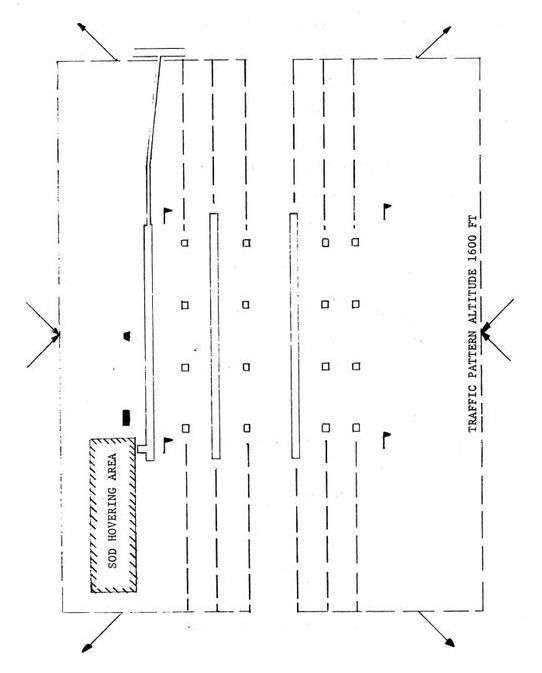
An undated diagram of Fort Wolters helicopter traffic procedures.
The airspace around the Fort Wolters training area was among the most crowded in the world.
It was especially congested when the training fleet returned back to the Main Heliport after the morning & afternoon training periods.
As the returning helicopters approached Fort Wolters, they formed into long “daisy-chains” of many dozens of aircraft.
To maintain spacing & ensure control, all landings & takeoffs at the Main Heliport were divided into East or West traffic patterns.
During landings, all approaching aircraft all entered the traffic pattern using either the East or West Area Marker as the Initial Point (IP) of entry.
The Area Marker was overflown at 1,500' in West traffic and 1,800' in East traffic.
Once the IP was passed, all traffic was separated further by splitting up to cross the Outer Markers.
These were large (24' x 24') panels on the ground that were painted different colors to be readily visible from the air.
As the brush & undergrowth was always cleared leading to them, they were easy to locate.
Crossing the Outer Markers, it was easy to follow the color-matched poles that led to the final Approach Marker which was overflown at 1,200' -
from the Approach Marker it was just a short distance to terminate the flight in a hover on the Approach Panel on the heliport.
It was a simple & safe procedure. Similar procedures were followed for take-offs.
Traffic using the Main Heliport stayed north of U.S. Highway 180,
while traffic using Downing AHP stayed to the south of U.S. Highway 180.
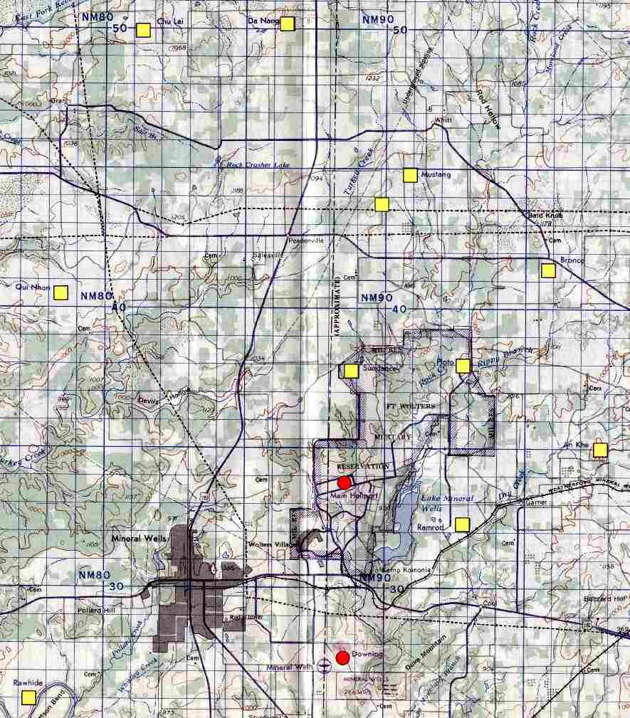
A portion of a circa late-1960s Crash Rescue Map, provided to all aviators at Fort Wolters from the late 1960s & onwards.
The complete map showed the position of all of the Stagefields & Heliports were shown, as well as civilian airfields.
An Aircraft Mishap Notification template was listed on the side of the map,
listing the radio frequencies for the main heliports as well as the Crash Rescue helicopter.
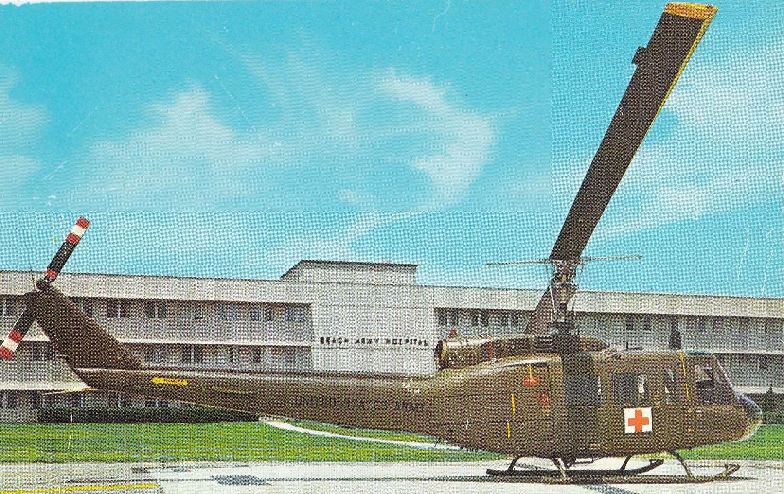
A circa 1960s view of a Bell medevac UH-1D in front of Beach Army Hospital at Fort Wolters (courtesy of Steve Cruse).
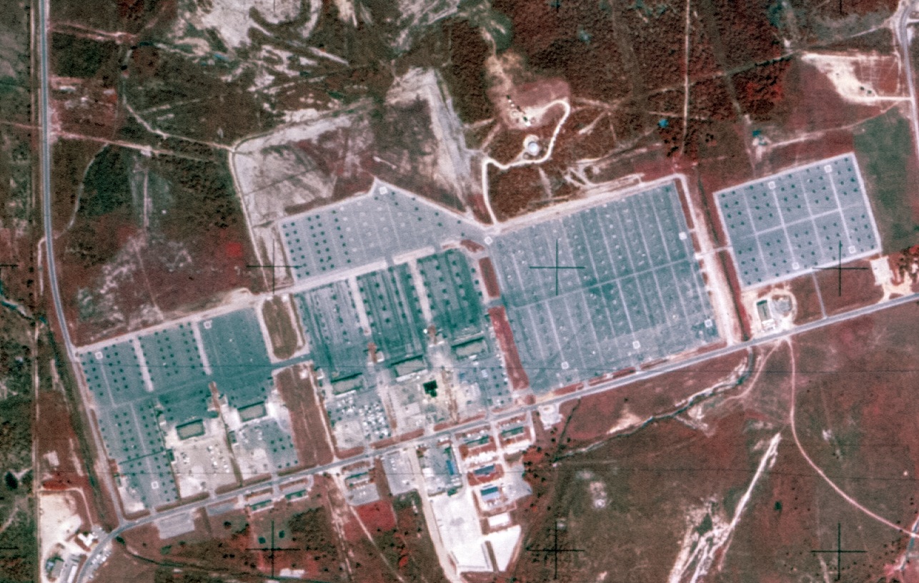
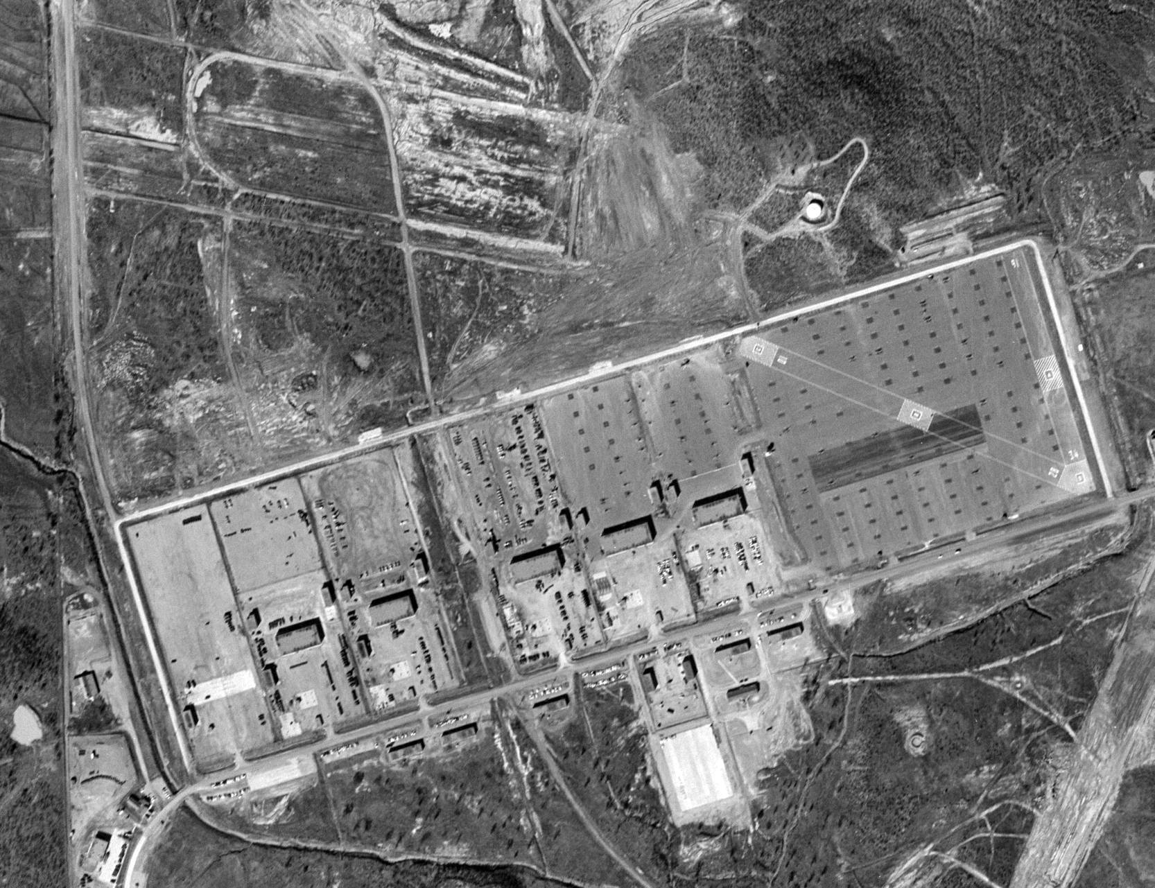
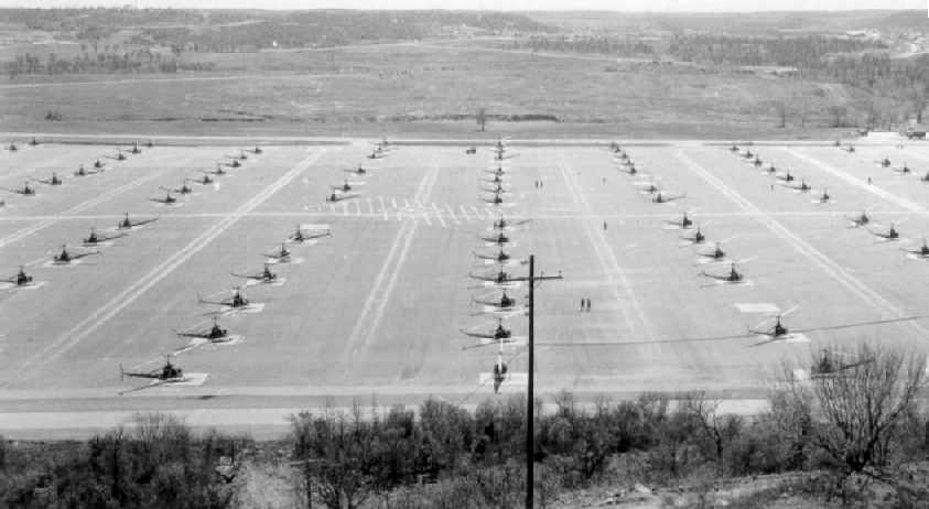
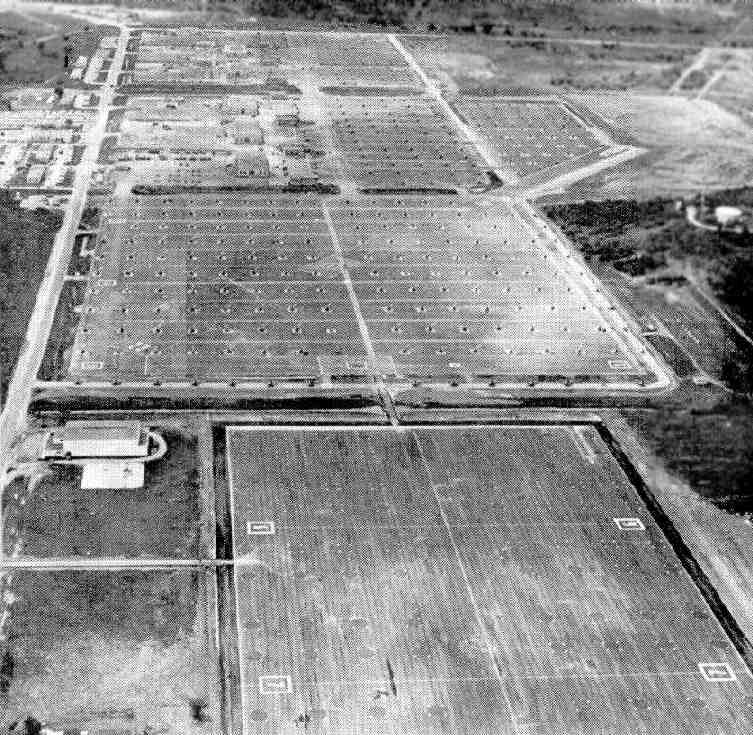
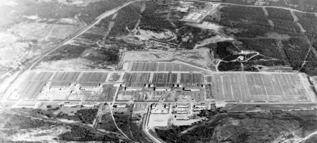
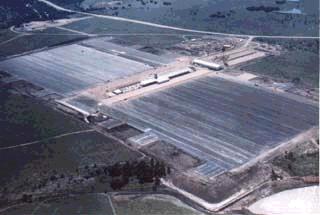
A 10/1/69 USGS aerial view depicted the huge number of helicopter parking spots on the massive Fort Wolters heliport, at the height of its service during the Vietnam War.
Fort Wolters also began training helicopter pilots for the Air Force in 1970.
By 1970 Fort Wolters covered 8,500 acres & leased an additional 1,700 acres.
A 4/16/70 U.S. Army aerial view looking northwest at Fort Wolters.
The deactivated Nike surface-to-air missile battery was also visible in the background.
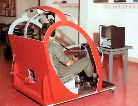
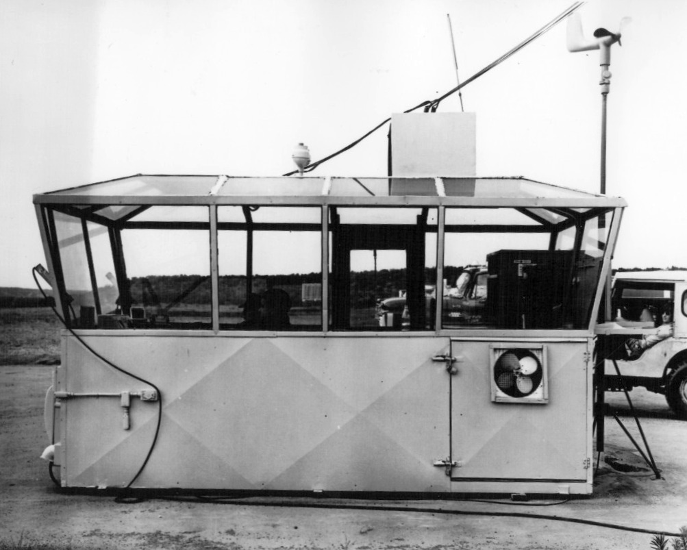
A 1971 U.S. Army photo of an extremely rudimentary “flight simulator” for a Hughes TH-55A Osage at Fort Wolters.
Who manufactured this simulator?
The last aeronautical chart depiction which has been located of Ft Wolters Army Heliport
was on the July 1971 Dallas Sectional Chart (courtesy of Ron Plante).
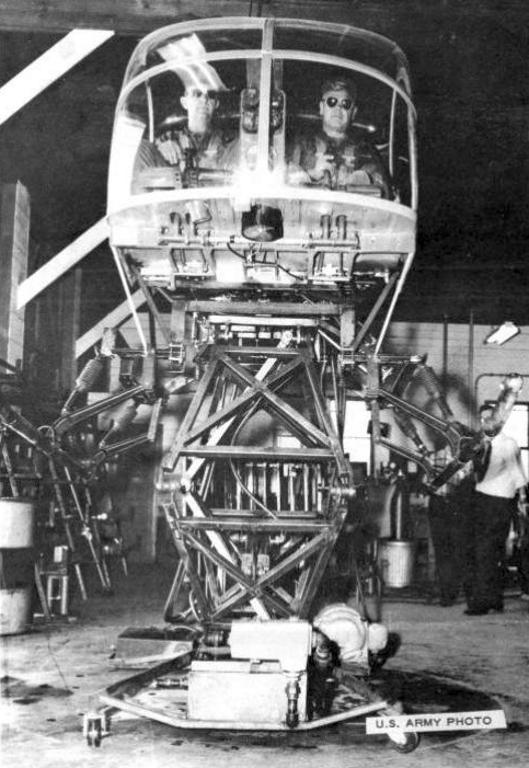
An undated U.S. Army photo from the August 1971 Southern Airways of TX Southern Views of a “Hover Simulator”
built by Fort Wolters personnel for $10,000 in parts, including a Hughes TH-55 cockpit mounted on a hydraulic motion base.
Over 41,000 students, representing over 30 countries,
graduated from the primary helicopter school at Fort Wolters during the 17 years it functioned in this capacity.
In 1973 the helicopter school transferred to the U.S. Army Aviation School at Fort Rucker, Alabama.
According to a 1999 historic sign, “Fort Wolters was officially closed for military service on 2/1/73.”
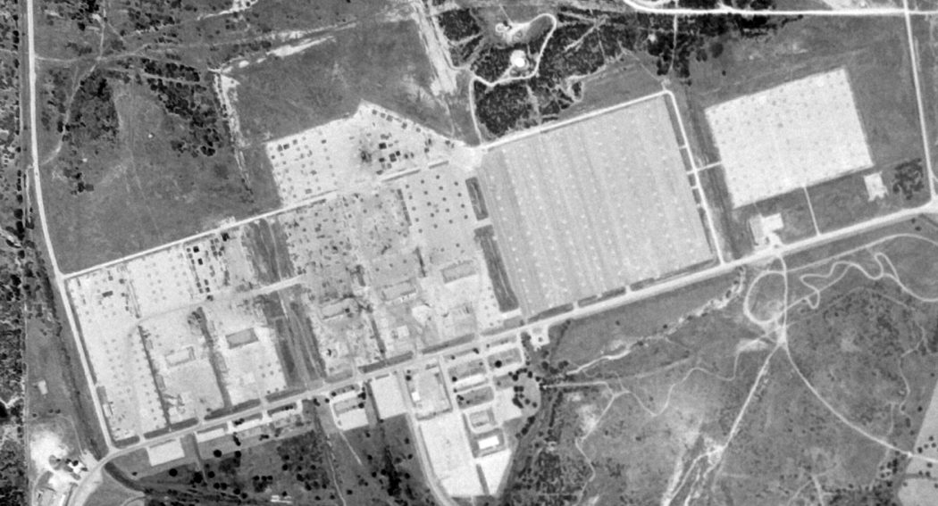
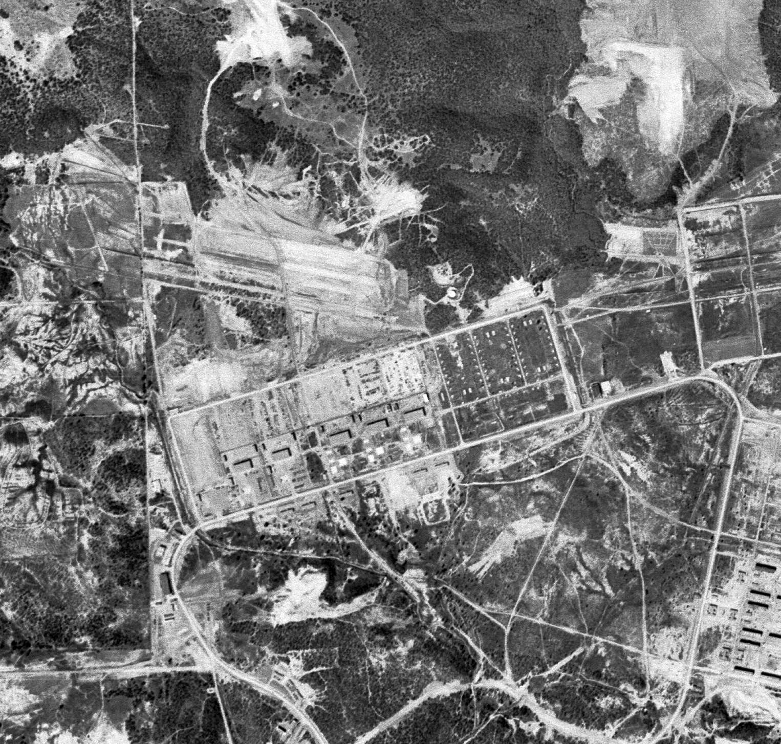
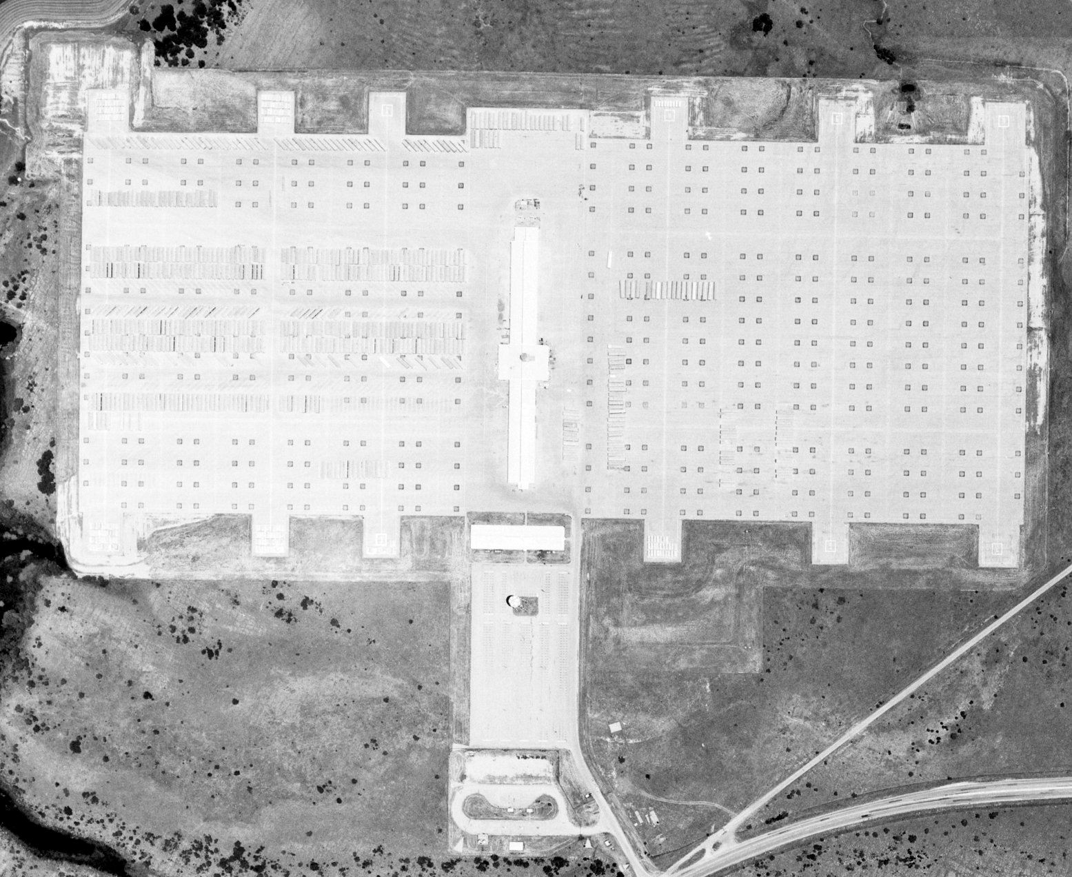
A 7/25/77 USGS aerial photo showed the massive Ft. Wolters ramp shortly after its closure.
By 1978, Ft. Wolters was no longer depicted at all (not even as an abandoned airfield)
on the DFW Sectional Chart (courtesy of Ray Brindle).
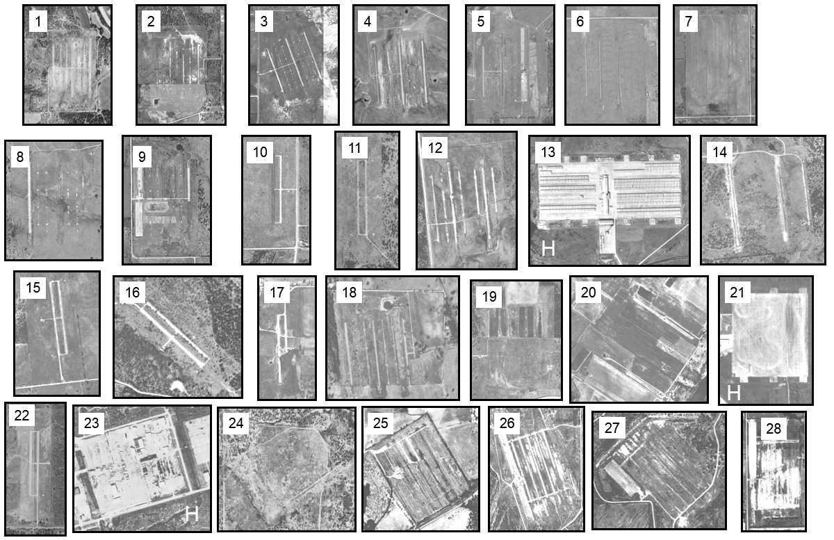
An Army Corps of Engineers composite of 1995/96 aerial photos showing the amazing number & variety of Fort Wolters Stage Fields.
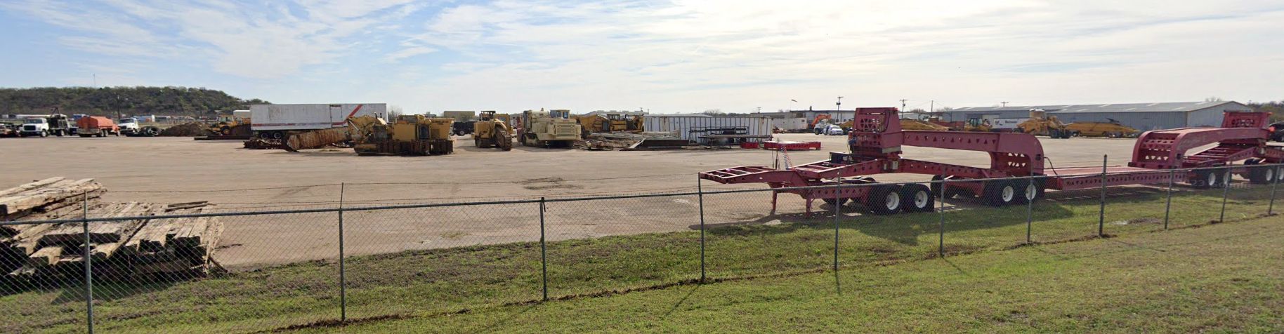
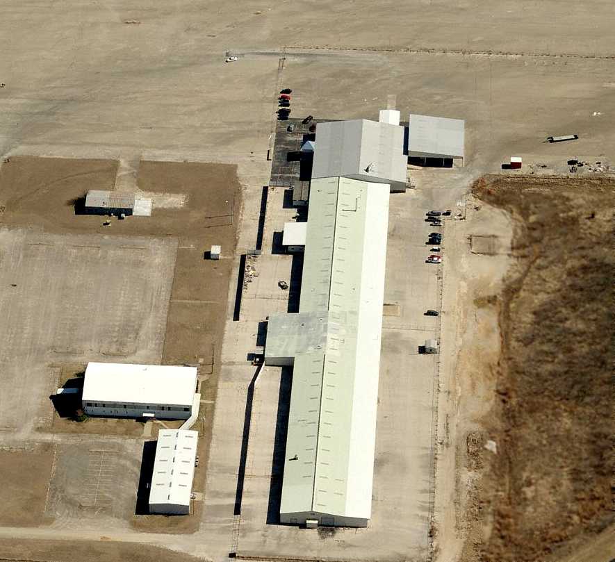
Part of the Fort Wolters land & facilities eventually became the Wolters Industrial Park, housing a number of businesses.
One of these businesses is Fort Wolters Helicopters,
which maintains the only active aviation facility at Fort Wolters, the Fort Wolters Helicopters Heliport.
Their business is located in the former engine shop of the Army Primary Helicopter Training Center.
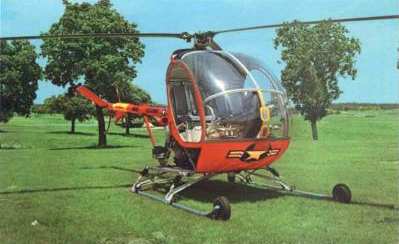
They specialize in refurbishing & resale of the Hiller UH-12 formerly operated by the Army at Fort Wolters.
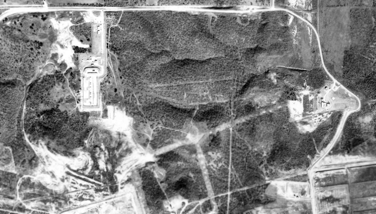
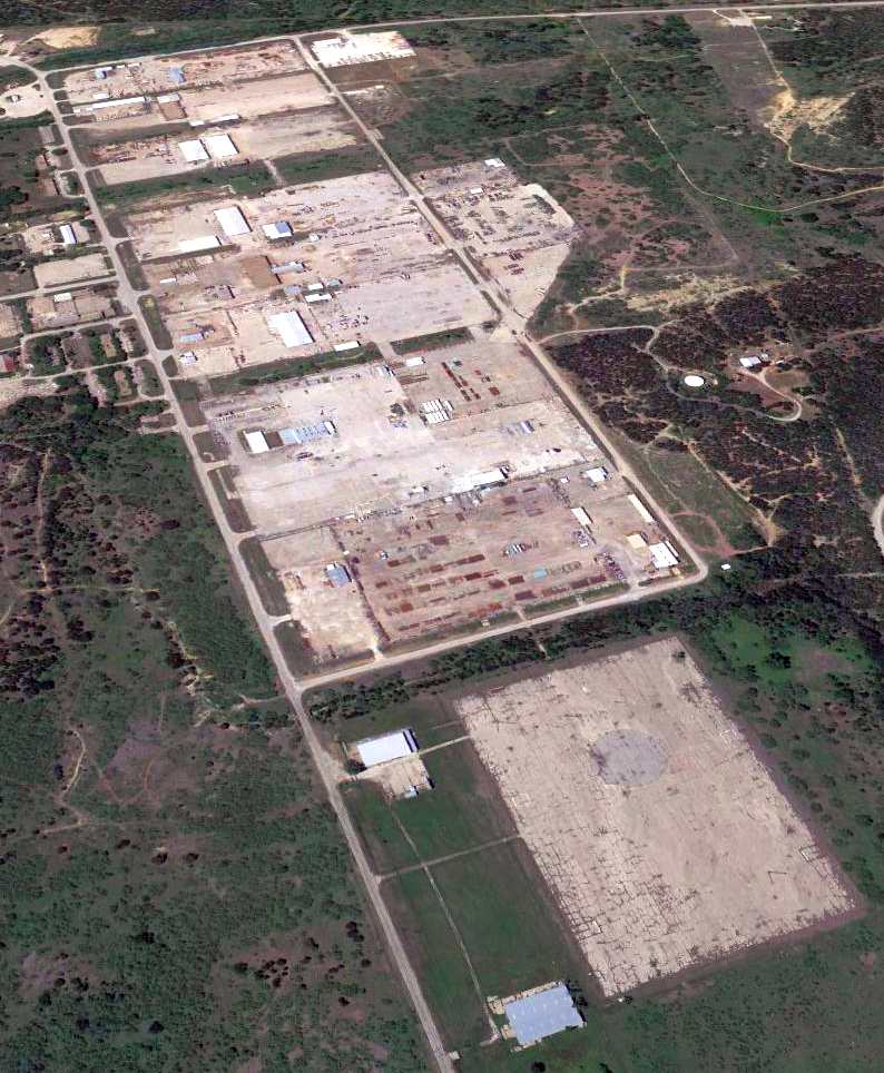
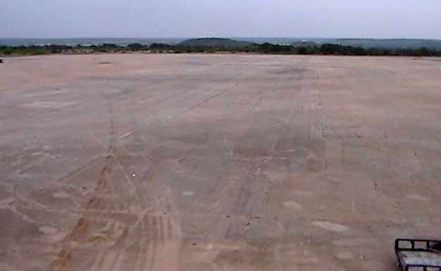
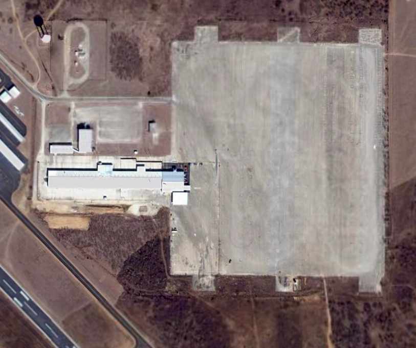
The remaining airfield facility at Fort Wolters consists of the
concrete helipad (approximately 4,300' x 1,200') & a large number of buildings.
At the site of the former Ft. Wolters Nike surface-to-air missile battery (just north of the helipad),
the remains of the 3 launchers still exist.
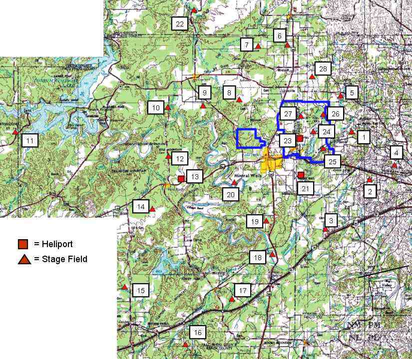
A 2003 Army Corps of Engineers map, showing the amazing number of Stage Fields (25) & heliports (3)
which encompassed the Fort Wolters helicopter flight training complex.
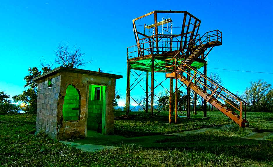
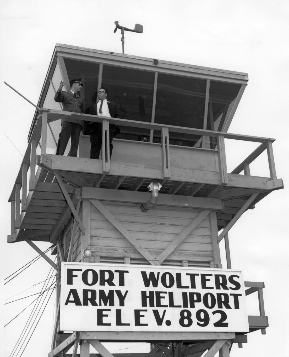
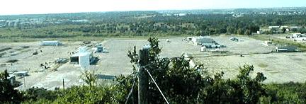
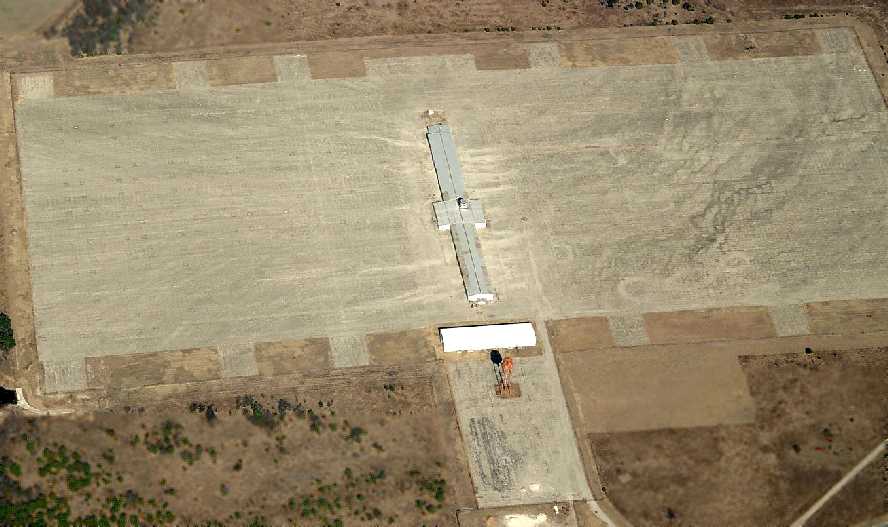
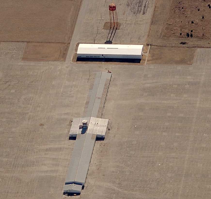
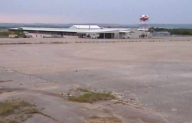
A 3/25/08 photo of the remains of the control tower on the hill overlooking the Fort Wolters heliport.
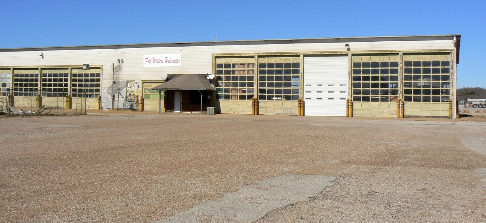
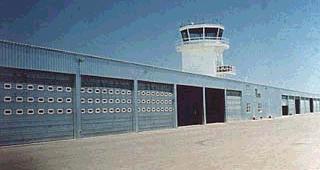
A 1/18/09 photo of the former Fort Wolters Army helicopter hangar.
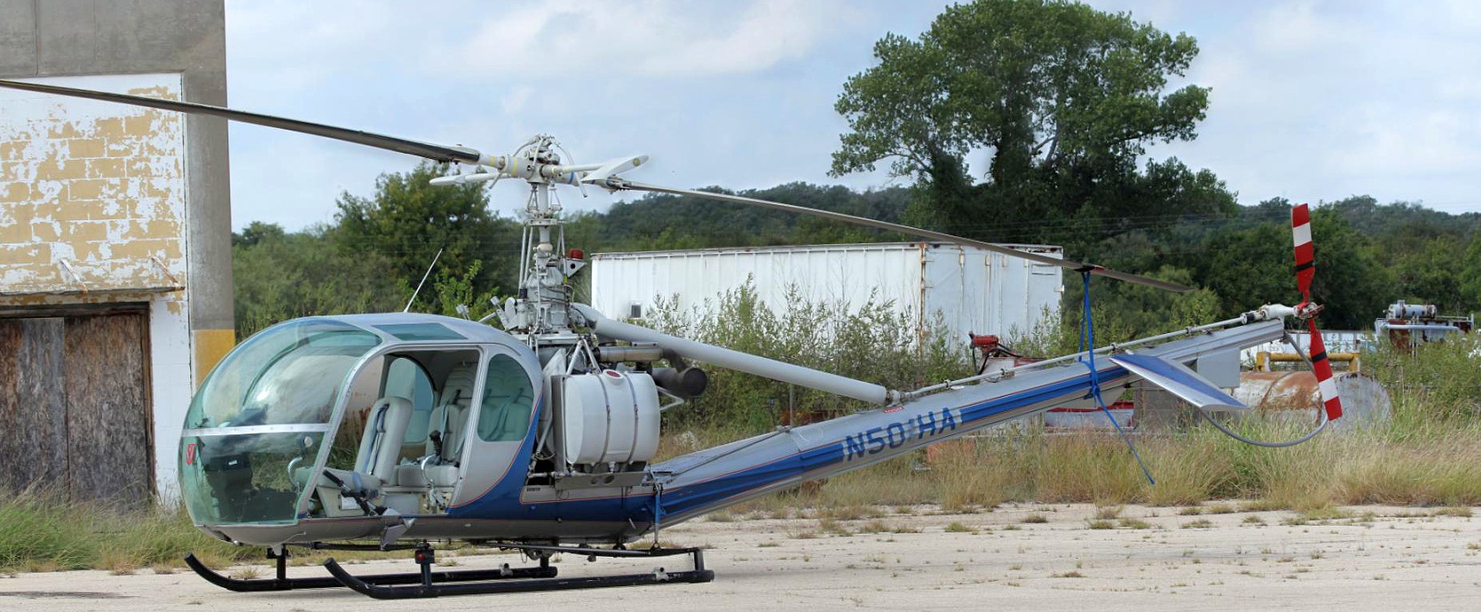
A 1/18/09 photo of a 1966 Hiller UH-12E4 at the Fort Wolters heliport.
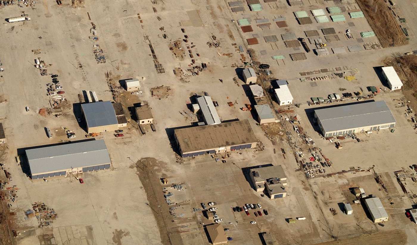
A circa 2010 aerial view looking north at the industrial buildings which occupy the huge former heliport at Fort Wolters.
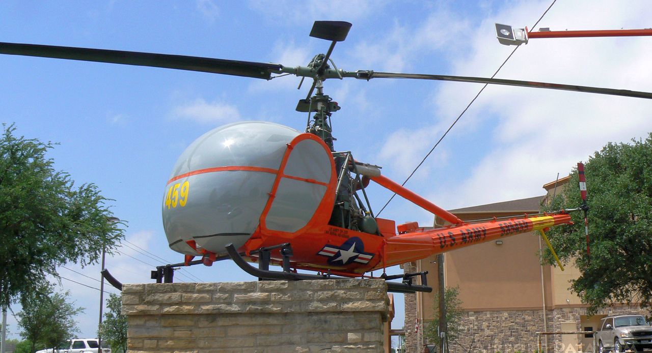
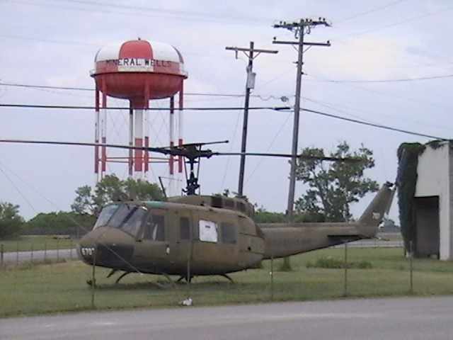
A 4/26/11 photo of N5985, a 1958 Hiller H-23D, serial #58-5459, which sits on display next to the main entrance to Fort Wolters.
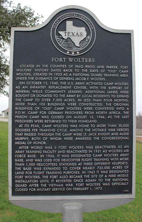
A 2/18/12 photo of a 1999 historic sign commemorating Fort Wolters.
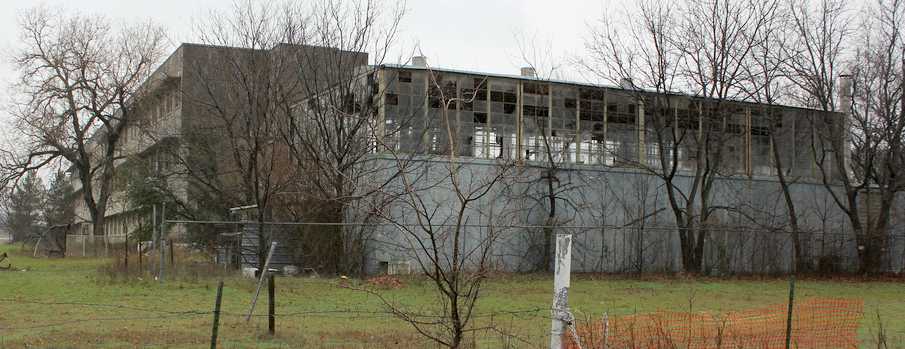
A 2/18/12 photo of the deteriorating Beach Hospital building at Fort Wolters.
According to Jamie Oakley, “The photo is of the newer hospital that was built just before the base was closed.
It sat empty until the 1990s when the city finally found a buyer, a married couple bought it for $100,000 at action.
They used the lobby as their home, and completely cleaned up the small hospital.
They don't have it now, not sure why, maybe passed away, who knows, but it looks in terrible shape, I saw it last year [2013].”
A 4/16/12 aerial view looking northwest along the remains of the Fort Wolters heliport.
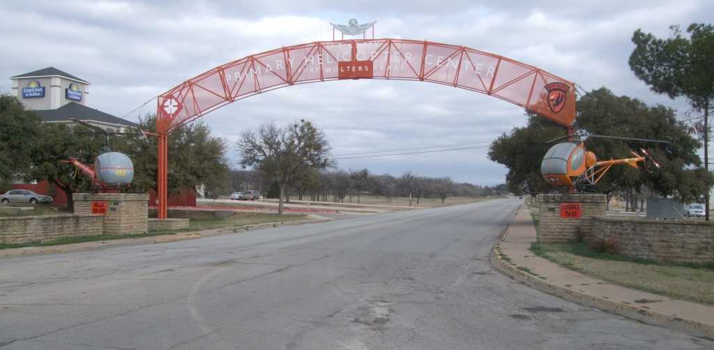
A March 2013 photo by Ron Plante of the Hiller OH-23 & Hughes TH-55 which still flank the main entrance to Fort Wolters.
A 2023 photo looking east at the remains of the Fort Wolters heliport.

A May 2024 photo by Mike Legeros of a Ft. Wolters memorial, flanked by helicopter rotor blades.

A May 2024 photo by Mike Legeros of the remains of the Ft. Wolters heliport.

A May 2024 photo by Mike Legeros of the former Ft. Wolters fire station, with windsock on top.

A 2/20/25 photo of the Hiller OH-23 & Hughes TH-55 which still flank the main entrance to Fort Wolters.
See also:
http://www.armyflightschool.org/rotary.htm
____________________________________________________
Fort Wolters Army Stage Field #1 / Pinto Stagefield, Garner, TX
32.88, -98.01 (West of Fort Worth, TX)
"Stage Field #1", as depicted relative to the main Fort Wolters Army Heliport on a 1960 Jeppesen Manual (courtesy of Chris Kennedy).
This airfield was one of at least 25 Stage Fields which were eventually used to support
the large-scale Army helicopter training program at Fort Wolters (4 miles to the southwest).
The date of construction of Stage Field #1 has not been determined,
but the helicopter training program at Fort Wolters began operating in 1956.
The earliest depiction of Stage Field #1 which has been located
was on a 1960 Jeppesen Manual (courtesy of Chris Kennedy).
Like the rest of the large number of Ft. Wolters Stage Fields, Stage Field #1 was not depicted on aeronautical charts of the times.
The only dated photo which has been located showing Fort Wolters Stage Field #1 in operation
was a 10/29/64 photo of civilians from Mineral Wells & Weatherford watching a helicopter demonstration,
with the control tower in the background.
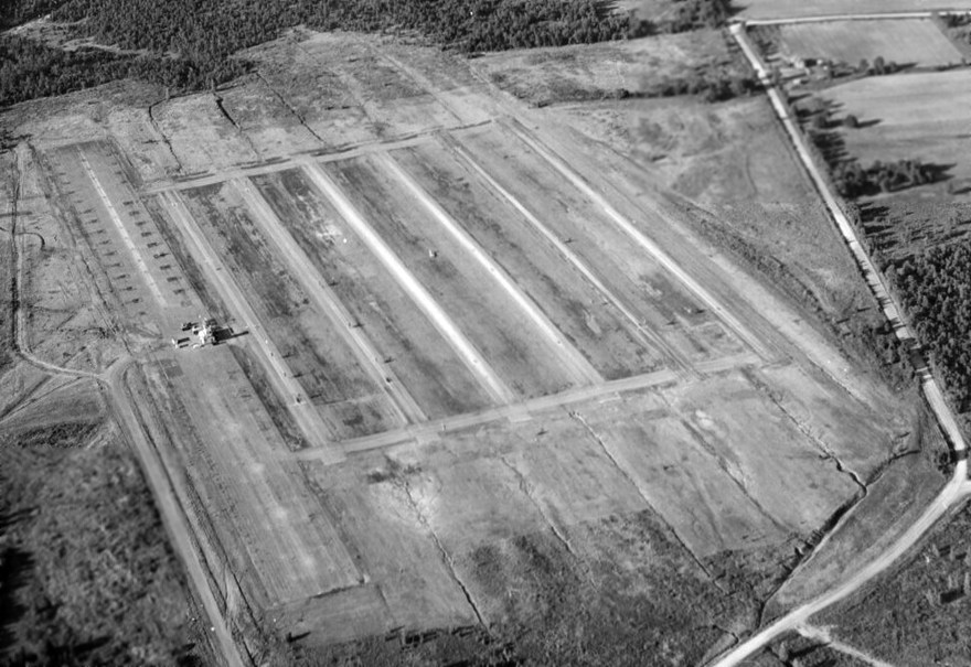
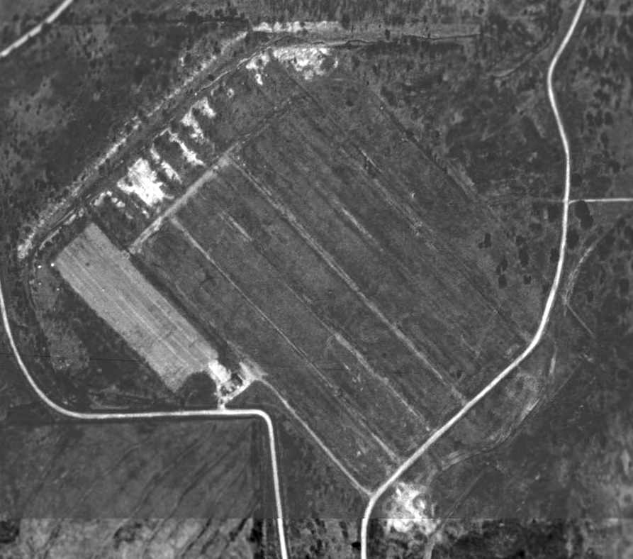
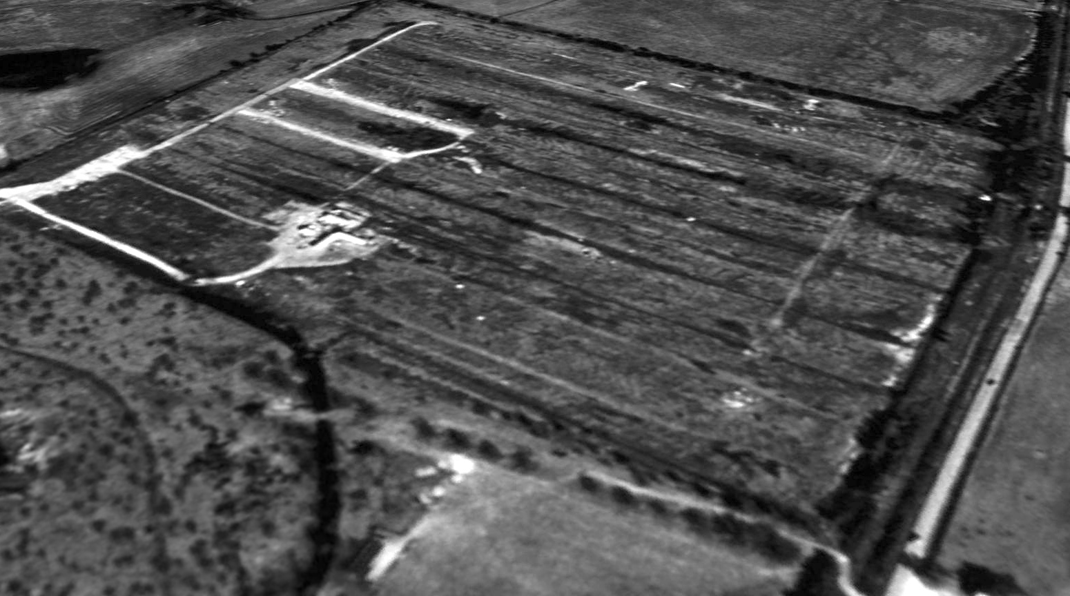
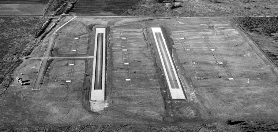
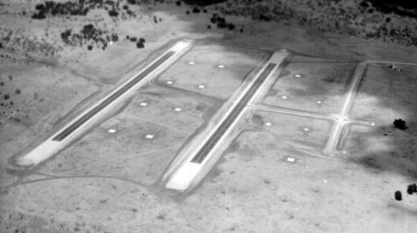
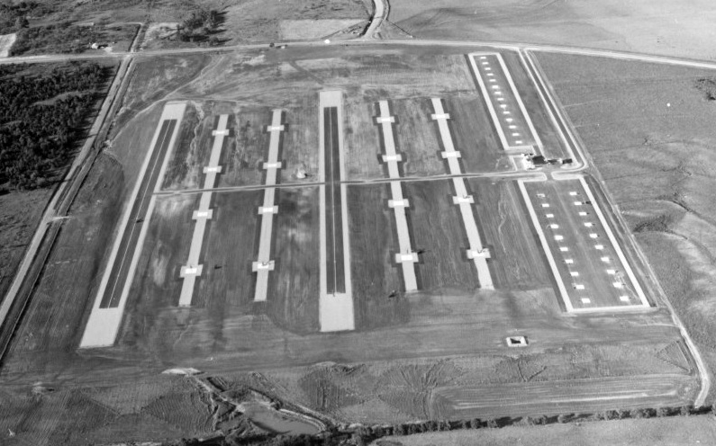
A circa 1960s aerial view looking northeast showing Fort Wolters Stage Field #1 / Pinto.
The airfield had a large paved ramp on the west side with helicopter parking pads, in the middle of which was a control tower.
To the east was a set of 6 parallel paved runways.
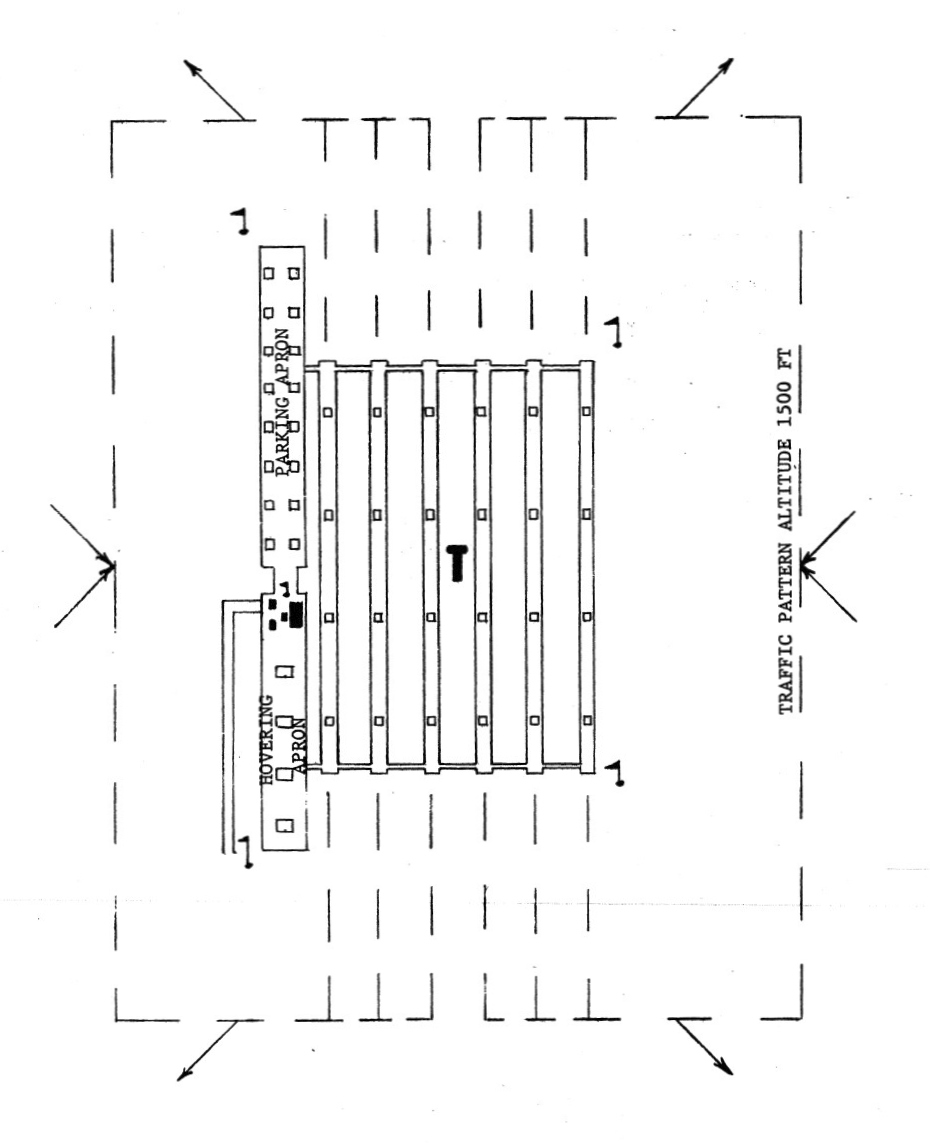
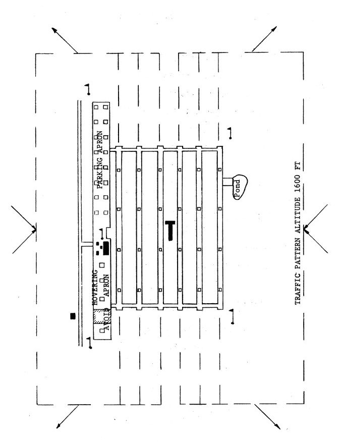
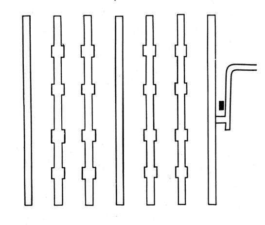
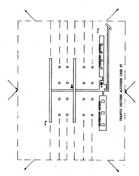
A circa 1960s airfield layout of Fort Wolters Stage Field #1 / Pinto,
showing the Parking Apron on the northwest, the Hovering Apron on the southwest, and 6 parallel runways on the east.
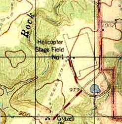
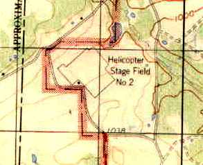
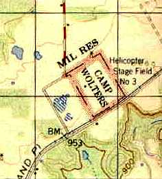
The July 1966 USGS topo map (courtesy of Chris Ness)
depicted "Helicopter Stage Field #1" as an outlined area, with no details within.
A circa late-1960s Crash Rescue Map labeled this Stage Field as “Pinto”.
Pinto Stage Field, as depicted on a 1/4/71 Army map of Fort Wolters Heliports & Stage Fields.
The use of this Stage Field definitely came to an end by 1973,
when the Army's helicopter training program at Fort Wolters was deactivated.
This Stage Field was not depicted at all on the July 1973 DFW Sectional Chart
or on USGS topo maps from 1973, 1983, or 1984.
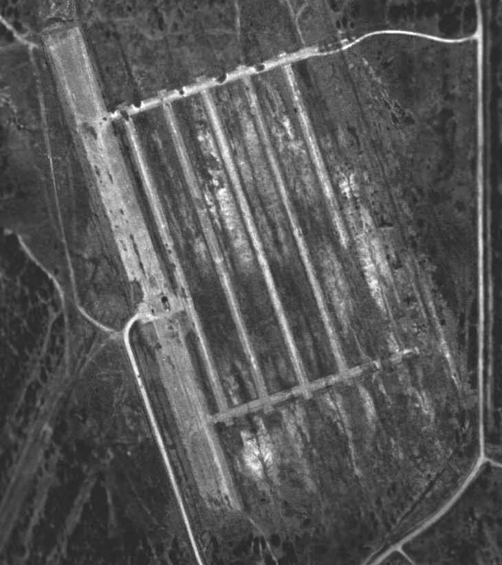
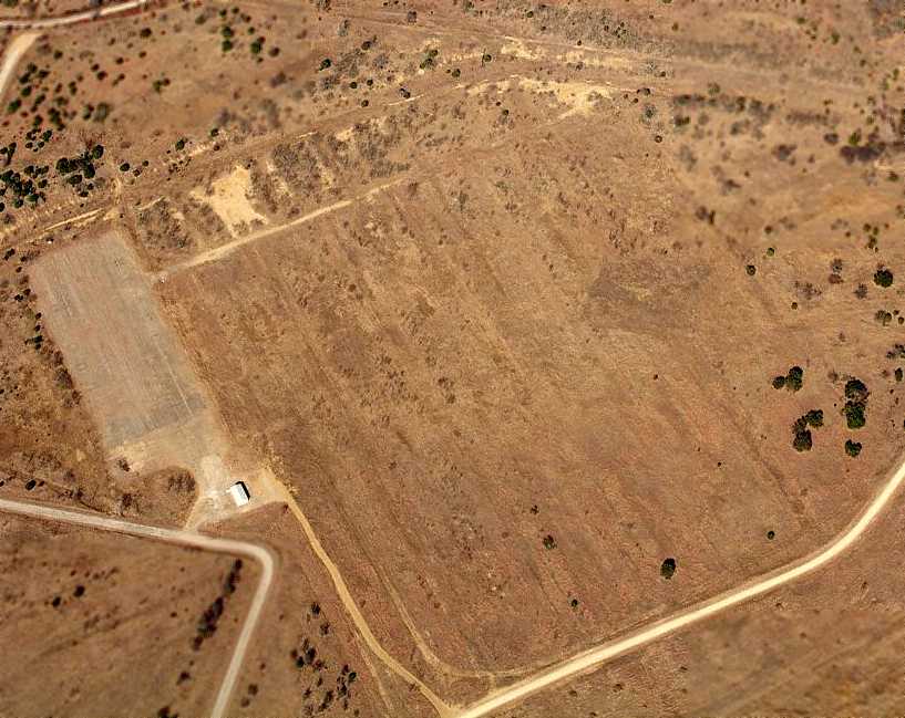
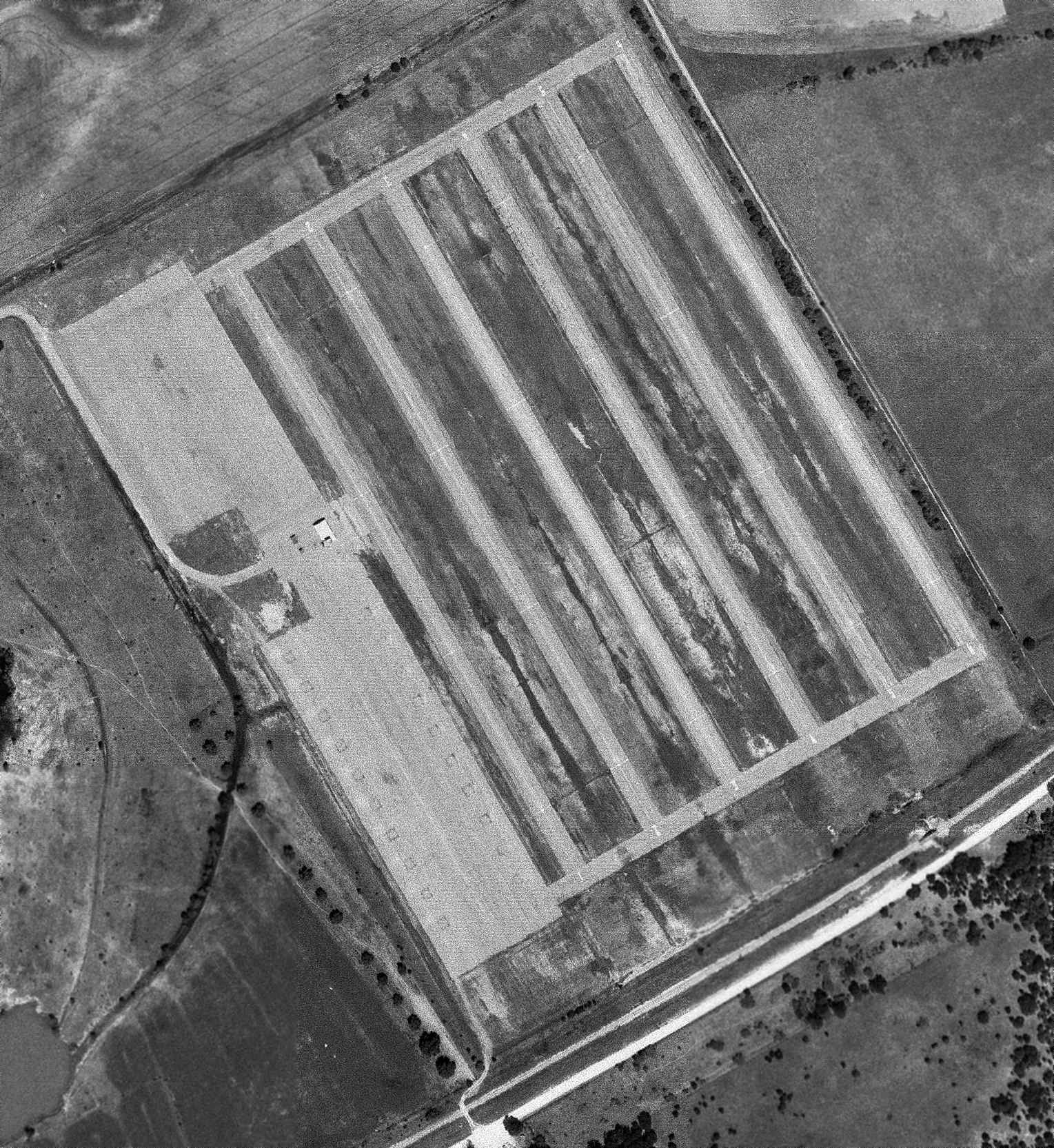
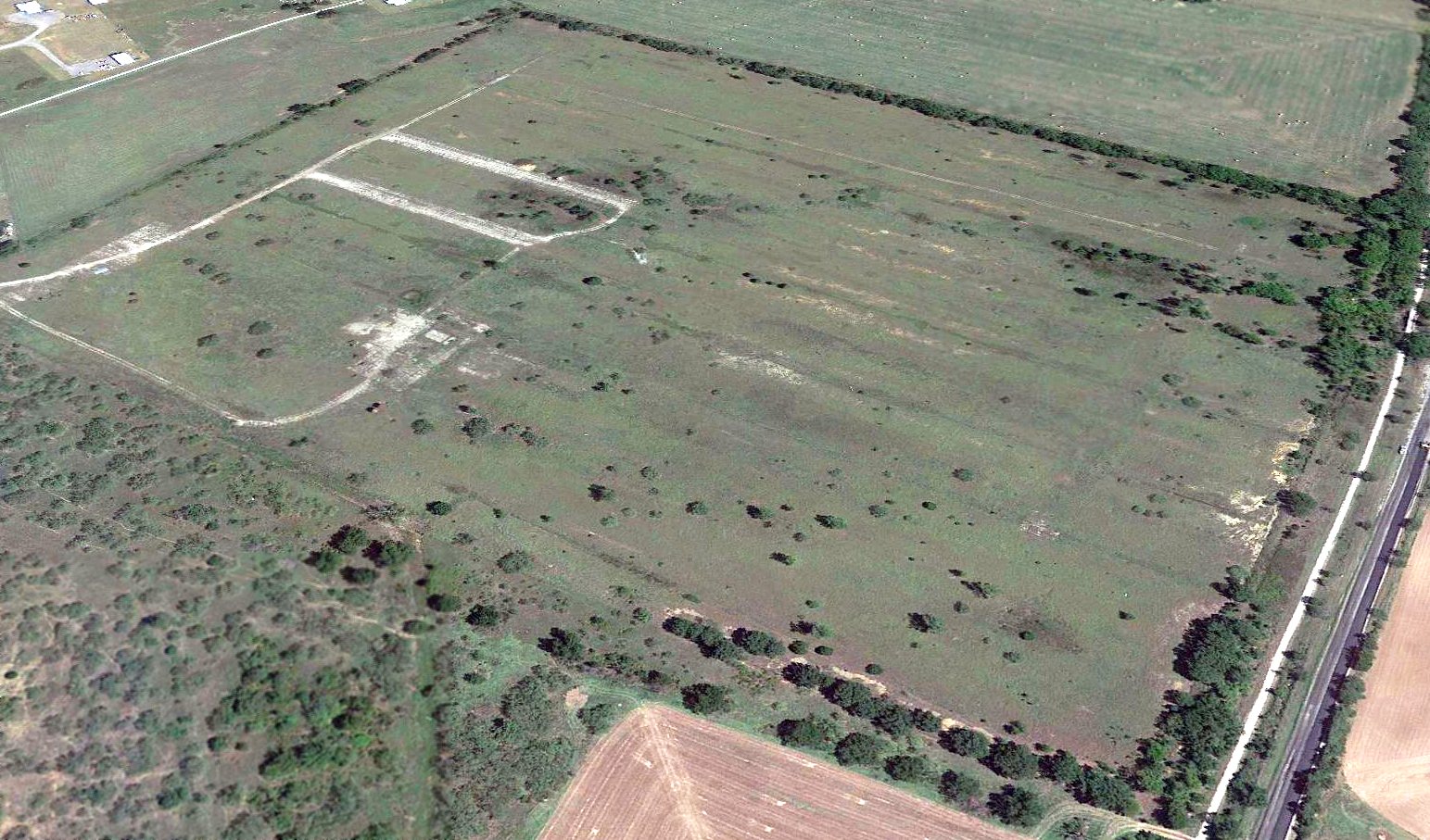
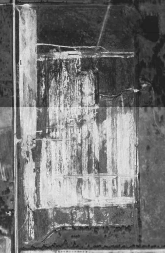
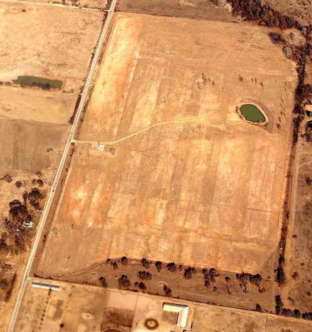
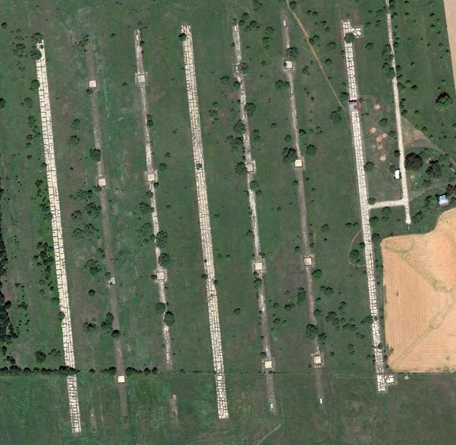
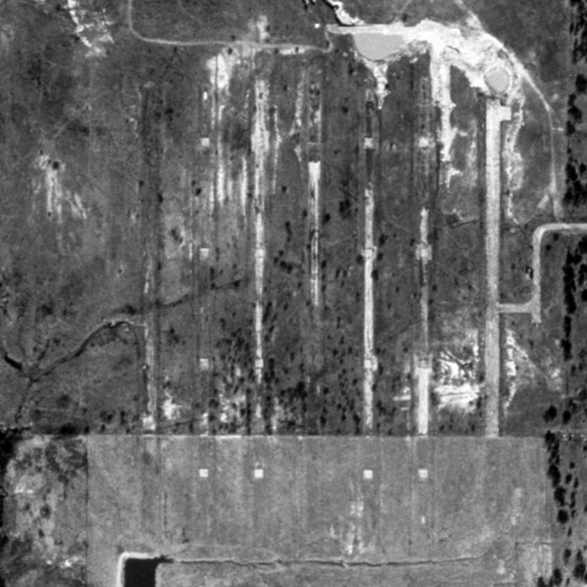
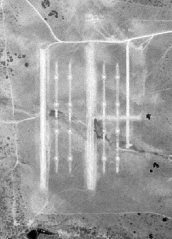
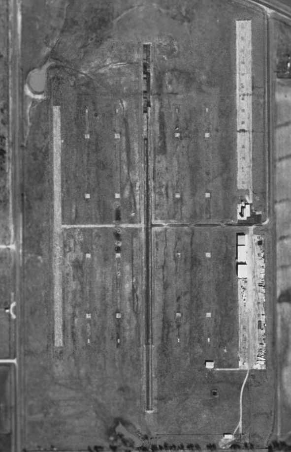
A 1995 USGS aerial photo showed Pinto Stage Field had a 2,400' paved runway or ramp area along the west side, along with 5 shorter paved strips, all arranged in parallel.
A small building had been constructed over the former western runway.

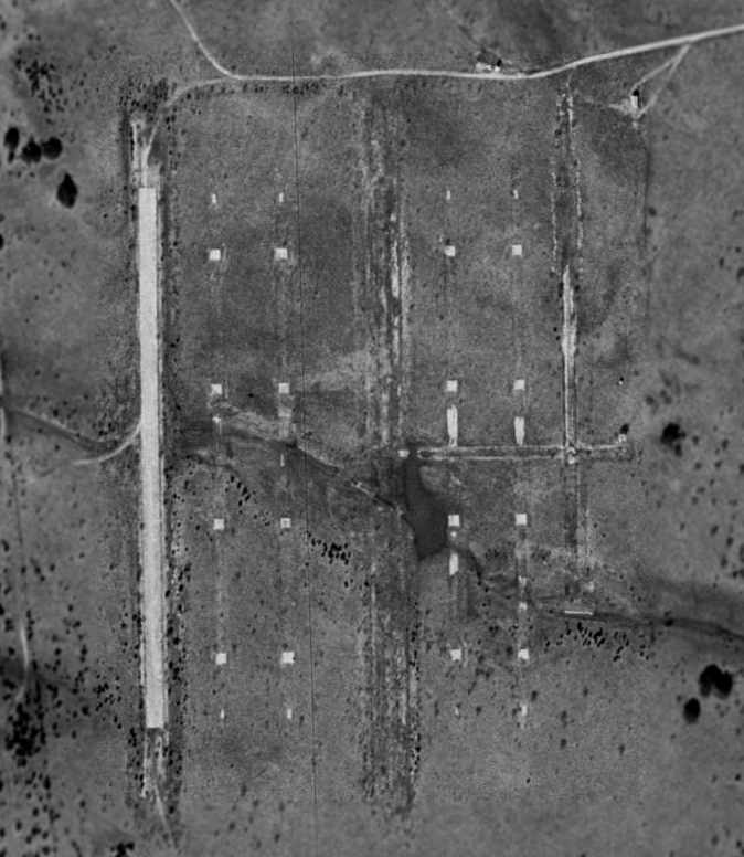
A 2023 aerial view looking northeast at the remains of Fort Wolters Stage Field #1.
Stage Field #1 is located southwest of the intersection of Route 113 & New Authon Road.
____________________________________________________
Fort Wolters Army Stage Field #2 / Sundance Stage Field, Salesville, TX
32.88, -98.05 (West of Fort Worth, TX)
"Stage Field #2", as depicted relative to the main Fort Wolters Army Heliport on a 1960 Jeppesen Manual (courtesy of Chris Kennedy).
This airfield was one of at least 25 Stage Fields which were eventually used to support
the large-scale Army helicopter training program at Fort Wolters (2 miles to the south).
The date of construction of Stage Field #2 has not been determined,
but the helicopter training program at Fort Wolters began operating in 1956.
The earliest depiction of Stage Field #2 which has been located
was on a 1960 Jeppesen Manual (courtesy of Chris Kennedy).
Like the rest of the large number of Ft. Wolters Stage Fields, Stage Field #2 was not depicted on aeronautical charts of the times.
The July 1966 USGS topo map (courtesy of Chris Ness)
depicted "Helicopter Stage Field #2" as an outlined area, with no details within.
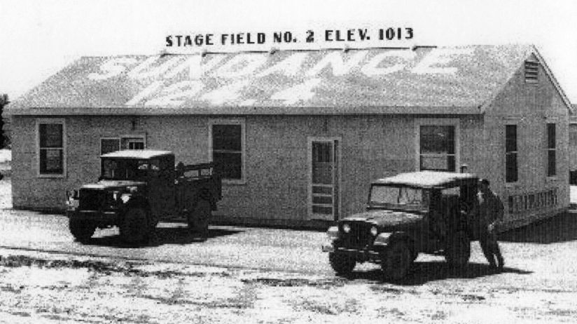
An undated photo of the Fort Wolters Stage Field #2 was operations building, which had “Sundance 124.4” (its radio frequency) painted on its roof.
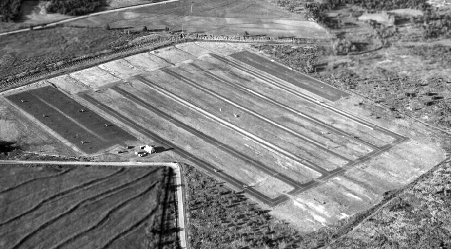
An undated aerial view looking north at Fort Wolters Stage Field #2
showed it to have a paved parking apron on the west, and operations building, and 6 paved parallel runways on the east.
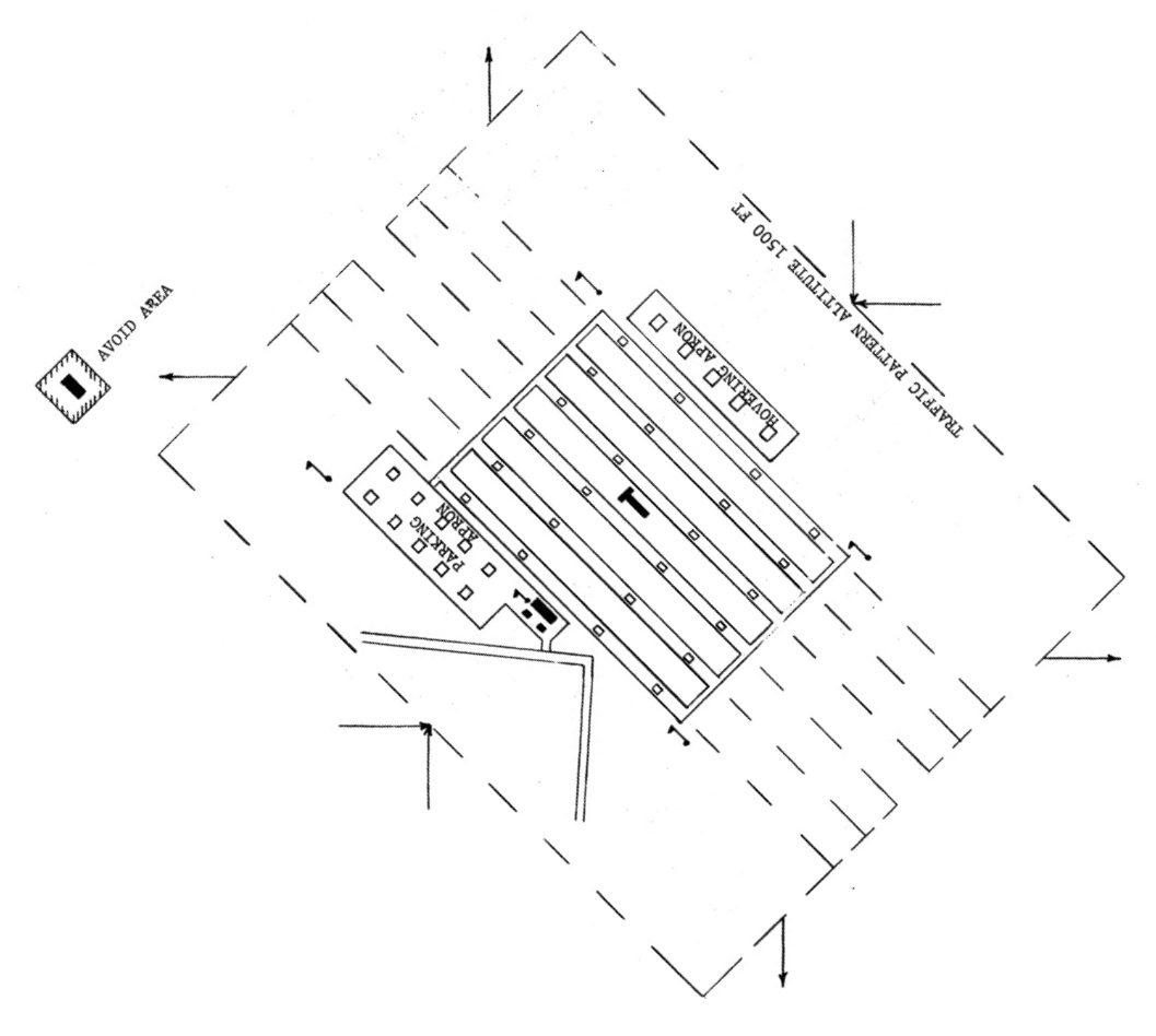
A circa 1960s airfield layout of Fort Wolters Stage Field #2 / Sundance
showing the Parking Apron on the west, 6 parallel runways in the middle, and a Hovering Apron on the northeast.
Chris Ness recalled, "#2 would have been right under traffic north of the field [of the main Fort Wolters Heliport].
I seem to recall my IP pulling a forced landing on me over old #2 the very first time I ever flew -
before I had ever done an auto-rotation."
A circa late-1960s Crash Rescue Map labeled this Stage Field as “Sundance”.
0
Sundance Stage Field, as depicted on a 1/4/71 Army map of Fort Wolters Heliports & Stage Fields.
The use of this Stage Field definitely came to an end by 1973,
when the Army's helicopter training program at Fort Wolters was deactivated.
This Stage Field was not depicted at all on the July 1973 DFW Sectional Chart
or on USGS topo maps from 1973, 1983, or 1984.
As seen in the 1995 USGS aerial photo,
this Stage Field consisted of a parallel group of 5 paved strips, each 1,600' long.
A paved ramp area sat on the west side of the field,
along with what may have been a single small building at the south side of the ramp.
A circa 2006 aerial photo looking north at the remains of Stage Field #2,
showed the landing strips to be far less recognizable than in the 1995 photo.
Stage Field #2 is located northeast of the intersection of Lamkin Road & Hayes Road.
____________________________________________________
Fort Wolters Army Stage Field #3 / Ramrod Stage Field, Garner, TX
32.825, -98.01 (West of Fort Worth, TX)
"Stage Field #3", as depicted relative to the main Fort Wolters Army Heliport on a 1960 Jeppesen Manual (courtesy of Chris Kennedy).
Photo of the airfield while in use has not been located.
This airfield was one of at least 25 Stage Fields which were eventually used to support
the large-scale Army helicopter training program at Fort Wolters (2 miles to the northwest).
The date of construction of Stage Field #3 has not been determined,
but the helicopter training program at Fort Wolters began operating in 1956.
The earliest depiction of Stage Field #3 which has been located
was on a 1960 Jeppesen Manual (courtesy of Chris Kennedy).
Like the rest of the large number of Ft. Wolters Stage Fields, Stage Field #3 was not depicted on aeronautical charts of the times.
The July 1966 USGS topo map (courtesy of Chris Ness) depicted "Helicopter Stage Field #3" as an outlined area, with no details within.
In Chris' words, "I don't remember ever seeing anything flying in the vicinity of #3 at all."
A circa late-1960s Crash Rescue Map labeled this Stage Field as “Ramrod”.
Ramrod Stage Field, as depicted on a 1/4/71 Army map of Fort Wolters Heliports & Stage Fields.
The use of this Stage Field definitely came to an end by 1973,
when the Army's helicopter training program at Fort Wolters was deactivated.
Ramrod Stage Field was not depicted at all on the July 1973 DFW Sectional Chart or the 1973 USGS topo map.
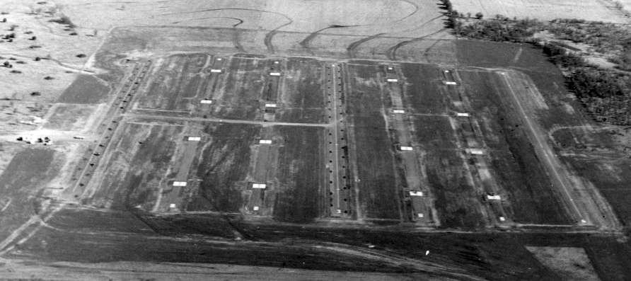
A 6/4/77 USGS aerial photo showed Ramrod Stage Field to consist of 6 parallel paved 1,800' northwest/southeast strips,
with a large paved ramp with numerous helicopter parking spots & a small building on the west side.
A 1995 USGS aerial view looking northeast showed Ramrod Stage Field was significantly more deteriorated than many of the other former Stage Fields,
as it appears as if all of the pavement had been removed,
and a home or other buildings appears to have been built over a portion of the site.
However, the characteristic Stage Field arrangement of the parallel strips was still quite recognizable.
A 2017 aerial view looking northeast showed Ramrod Stage Field was almost unrecognizable as a former airfield,
with only small portions of the airfield pavement remaining.
Stage Field #3 is located northeast of the intersection of Lamkin Road & Hayes Road.
____________________________________________________
Fort Wolters Army Stage Field #4 / Mustang Stage Field, Salesville, TX
32.94, -98.03 (West of Fort Worth, TX)
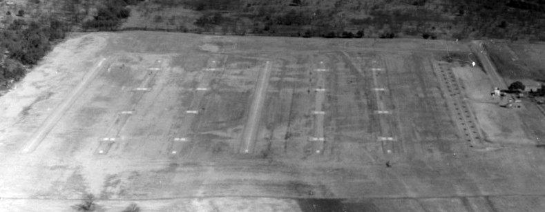
A January 1959 US Army Corps of Engineers aerial photo of Ft. Wolters Stage Field #4.
This airfield was one of at least 25 Stage Fields which were eventually used to support
the large-scale Army helicopter training program at Fort Wolters (7 miles to the southwest).
The date of construction of Stage Field #4 has not been determined,
but the helicopter training program at Fort Wolters began operating in 1956.
The earliest depiction which has been located of Stage Field #4
was a January 1959 US Army Corps of Engineers aerial photo.
It depicted the field as having 6 parallel north/south runways.
A total of 20 helicopter landing pads were clustered in 2 rows along the west side of the field,
along with 1 or 2 small buildings.
Like the rest of the large number of Ft. Wolters Stage Fields, Stage Field #4 was not depicted on aeronautical charts of the times.
"Stage Field #4", as depicted relative to the main Fort Wolters Army Heliport on a 1960 Jeppesen Manual (courtesy of Chris Kennedy).
A 1966 U.S. Army aerial view looking north at Stage Field #4.
A circa 1960s airfield layout of Fort Wolters Stage Field #4 / Mustang
showing the Parking Apron on the northwest, a Hovering Apron on the southwest, and 6 parallel runways on the east.
Stage Field #4 also had a field house, control tower, and connecting crash truck lanes.
A circa 1960s photo of the elaborate control tower at Fort Wolters Stage Field #4 / Mustang.
A 1968 photo of 3 Hiller OH-23D Ravens at Stage Field #4.
A circa late-1960s Crash Rescue Map labeled this Stage Field as “Mustang”.
Mustang Stage Field, as depicted on a 1/4/71 Army map of Fort Wolters Heliports & Stage Fields.
The use of this Stage Field definitely came to an end by 1973,
when the Army's helicopter training program at Fort Wolters was deactivated.
This Stage Field was not depicted at all on the July 1973 DFW Sectional Chart
or on USGS topo maps from 1973, 1983, or 1984.
As seen in the 1995 USGS aerial photo,
this Stage Field appears to have originally had a similar configuration as that of the other former Stage Fields,
with several rows of parallel strips with numerous helicopter landing pads.
However, unlike many other stage fields, this one appears to have had all of its pavement removed at some point.
A circa 2006 aerial photo looking north at the remains of Fort Wolters Stage Field #4.
Stage Field #4 is located southeast of the intersection of Bounty Road & Whitt Cutoff Road.
____________________________________________________
Dempsey Army Heliport, Palo Pinto, TX
32.78, -98.27 (West of Fort Worth, TX)
A circa 1960s photo of Bell OH-13s on the ramp at Dempsey Army Heliport (courtesy of Steve Cruse).
This large helicopter facility was built as a satellite field
for the large-scale helicopter training program at nearby Fort Wolters.
It was constructed on 160 acres of government-owned land.
Dempsey Army Heliport opened in 1968, according to Chris Ness (who soloed at Fort Wolters).
The concrete helipad (approximately 3,900' x 1,600') contained parking spaces for 476 helicopters
together with a 65,000 square-foot maintenance hangar, 39 briefing rooms, a fire station,
a self-contained sewage disposal plant, administrative offices & a control tower.
Like the rest of the large number of Ft. Wolters Stage Fields, Dempsey Army Heliport was not depicted on aeronautical charts of the times.

A circa 1960s photo of Hughes TH-55A Osages on the West Ramp at Dempsey Army Heliport, with the control tower in the background.
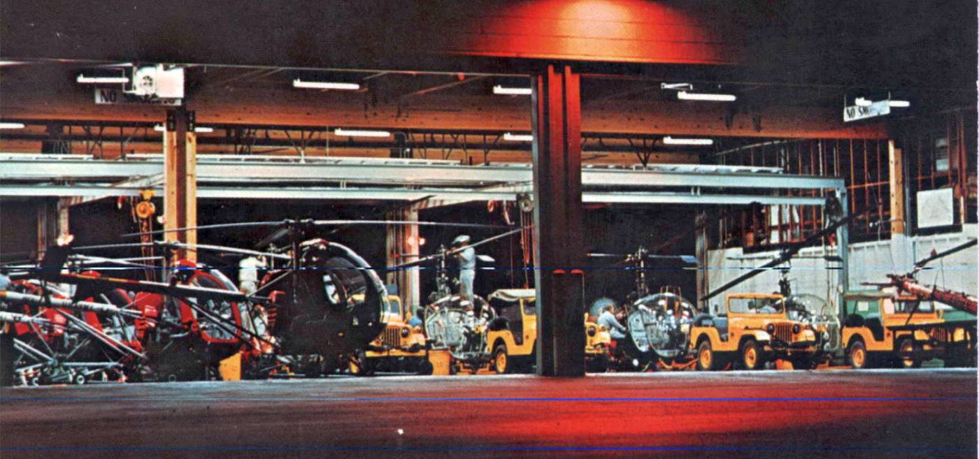
A circa 1960s nighttime view of Hughes TH-55A Osages & Bell TH-13s inside the Dempsey Army Heliport maintenance hangar.
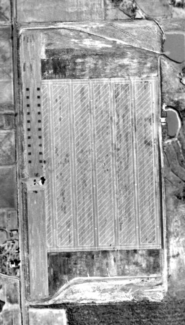
An April 1968 aerial view looking south at Dempsey Heliport, showing large numbers of helicopters on the field.
A 1960s aerial view looking northeast at Dempsey Heliport.
Nothing was depicted at the site of Dempsey Army Heliport on the 1969 USGS topo map.
A 1970 U.S. Army aerial view looking northwest at Dempsey Heliport,
showing what appear to be large numbers of helicopters on the field.
Dempsy Heliport, as depicted on a 1/4/71 Army map of Fort Wolters Heliports & Stage Fields.
The date closure of Dempsey by the Army has not been determined,
but flight training operations at Fort Wolters ended in 1973.
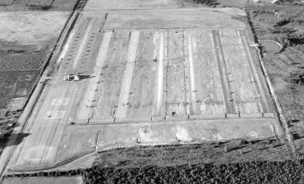
A 6/7/77 USGS aerial view depicted Dempsey Army Heliport as being marked with a huge number of helicopter landing spots,
but there appeared to be trailers stored on the heliport.
An aerial view looking southeast at Dempsey shortly after its Army use.
By 1978, Dempsey Army Heliport was no longer depicted at all (not even as an abandoned airfield)
on the DFW Sectional Chart (courtesy of Ray Brindle).
The Dempsey Army Heliport facilities were still depicted on the 1984 USGS topo map, but without any label.
Justin recalled, “Palo Pinto... I drove up to there back in 1986.
There was no activity, no vehicles, nothing that I recall.
I looked through a window on the southeast corner of the long east/west-stretching building under the red & white water tower.
I noticed an unusual helicopter inside, small than the Osage...It might have been the hover training aircraft”, a Del Mar DH-1A Whirlymite.
A recent (pre-2003) view of the Dempsey tower & hangars.
A faded sign indicates it is now the Dempsey Strategic Storage Center,
of the Federal Emergency Management Agency (FEMA).
Nearly all of the helipad area is now being used for storage.
Mac Mack reported in 2003 that "The rectangular shapes at the old Dempsey AAF are mobile homes / trailers
that FEMA takes to disasters for use by people whose homes have been destroyed, damaged, etc.
After such an event occurs we see them on the local freeways outbound,
and after a while they return, to be used again the next time they are needed."
A circa 2006 aerial view looking north at the former Dempsey heliport,
showing it to be completely devoid of the trailers mentioned previously being stored at the facility.
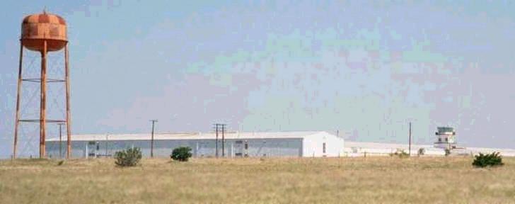
A circa 2006 aerial view looking south at the Dempsey control tower, hangars, and water tower.
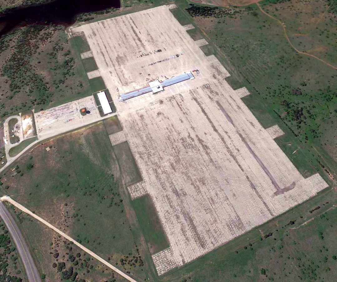
A 4/16/12 aerial view looking northwest at the former Dempsey heliport.
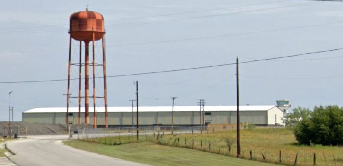
A 2023 photo looking northwest at the water tower, hangar, and control tower of the former Dempsey heliport.
See also: http://www.airforcebase.net/trips/wtex2k/tr_wtex2k.html
____________________________________________________
Downing Army Heliport, Mineral Wells, TX
32.78, -98.05 (West of Fort Worth, TX)
According to Fort Wolters History by Willie Casper, “The main heliport on Camp Wolters ran out of training & maintenance space in 1964.
The City of Mineral Wells offered to lease their property east & adjacent to the Mineral Wells Municipal Airport
to support the expanding primary helicopter [training] mission.
To offset the rapid requirement for helicopter pilots in Vietnam,
the most modern heliport in the world was built & dedicated 9/30/66.
It was named Downing Army Heliport in memory of Col. Wayne Downing,
the 1st Assistant Commander of the U.S. Army Primary Helicopter School.”
The Downing Army Heliport was constructed adjacent to the east side of the civilian Mineral Wells Municipal Airport (MWL),
on 97 acres of land leased from the city for $1/year.
It consisted of a concrete helipad having parking spaces for no less than 300 helicopters (measuring approximately 1,600' x 1,500'),
and a very long hangar (64,000 square feet; nearly 800' long),
16 briefing rooms, a fire station, administrative offices & a control tower.
Like the rest of the large number of Ft. Wolters Stage Fields, Downing Army Heliport was not depicted on aeronautical charts of the times.
Cecil Lucas recalled, “I was a mechanic At Fort Wolters.
In October of 1966 I was transferred to Downing Heliport which had just been completed.”
A 10/24/66 US Army aerial view by William Phillips looking north at a portion of Downing Army Heliport on the east side of Mineral Wells Airport.
On 4/13/67 a heavy wind storm, possibly a tornado, struck the Downing Heliport damaging 179 TH-55A helicopters.

An aerial view of some of the 179 Hughes TH-55A Osages damaged by a 4/13/67 heavy storm at Downing Heliport.
In what was named Operation Recoup, 9,000 pounds of replacement parts from the Hughes factory along with personnel from Hughes & other Army facilities
were rushed to Downing to affect priority repairs to the huge number of storm-damaged TH-55As,
and the 179 helicopters were repaired in an amazing 50 days.

A 1969 photo showing dozens of Hughes TH-55 Osages at Downing Army Heliport from the cockpit of another TH-55.
A circa 1960s-70s aerial view of Downing during its use by the Army.
Note the large number of helicopters parked at heliport, and runways of Mineral Wells Airport in background.

A 1970 U.S. Army aerial view looking north at Downing Heliport,
showing what appear to be large numbers of helicopters on the field.
Downing Heliport, as depicted on a 1/4/71 Army map of Fort Wolters Heliports & Stage Fields.
According to Fort Wolters History by Willie Casper, “The Army closed the Downing Heliport in 1973
to coincide with the phaseout of the helicopter training at Fort Wolters.”
Chris Walton reported in 2003, "I've visited it many times.
For many years, the old heliport has been used for autocrosses (a kind of low-speed time trial)
by 2 Dallas/ Fort Worth area sports car clubs,
Equipe Rapide Sports Car Club & the Texas Region of the Sports Car Club of America (SCCA).
The Porsche Club of America has also run many autocrosses there
and has also used the track for high-speed drivers' schools.
The squiggly line that's vaguely visible in the 1995 aerial photograph
is the Porsche Club's high-speed track.
The site has hosted numerous large invitational SCCA autocross events in past years,
and has become affectionately known as the Mineralring (after the Nurburgring racetrack in Germany).
However, the asphalt surface at the heliport has deteriorated badly in the last several years
to the point that it doesn't have enough grip for auto racing,
and several better-paved & more conveniently located racing sites have recently opened in the area.
The site is gradually being phased out by the local car clubs
and probably won't be used for racing at all within the next few years."
Chris continued, "The long, tan-colored metal hangar in the lower left-hand corner of the aerial photo
was used during the late 1990s by a local manufacturer of manufactured housing (i.e. mobile homes)
but the operation closed a couple of years ago
and the building has since been abandoned & surrounded by a tall sheet-metal fence.
The little metal building to the upper right of the hangar appears military
and has always looked like some sort of fueling facility to me;
it has been boarded up ever since I first saw it.
The building to the upper left looks like an ordinary 1980s-era concrete industrial building;
it does not look military & doesn't look old enough to date from the heliport days."
A 2005 photo by Gregg Lee of the former Downing Heliport.
Gregg Lee gave a somewhat different account in 2005:
“At least 5 different sports car clubs rent the helipad regularly for autocross & trials.
Clubs have over 40 days scheduled for autocrosses,
trials and schools in 2005, probably the most ever.
While the City of Mineral Wells has invested next to nothing to maintain the site,
last year those who use the pad began a project to clear brush & dirt which continues.
There are some small damaged pavement areas,
many created a few years ago by trucks cutting across to a gas well on the south side,
and a weak pavement area toward the east side that seems to have a seep beneath it, but no wholesale breakup.
Grip is comparable to other asphalt autosports sites.”
Gregg continued, “Last year the city held its annual fireworks display on the helipad.”
Gregg continued, “The approximately 30' x 50' metal building adjacent to the helipad,
which I have heard called the 'fuel building',
is currently unoccupied but well maintained, with for example, air conditioning installed.
A city employee recently called it the 'firehouse'.”
Model airplane hobbyists often set up on the drive in front of this building.”
A 2005 photo by Gregg Lee of the buildings adjacent to the former Downing Heliport.
Gregg observed, “The water tower is still military red & white.”
Gregg continued, “A company called DRS occupies the long hangar plus an extension added by a previous tenant,
and about 15% of the original pad, now fenced off by chain link fence.
DRS makes Remotely Piloted Vehicles which appear to have 6-8' wingspan.
Another company called STEC occupies several other building on the airport.”
A 2005 photo by Gregg Lee of a static-display UH-1 which “was recently installed in front of the terminal.”
A 2006 aerial photo of the former Downing Army Heliport & hangar.
A circa 2006 aerial view looking east at the former Army helicopter hangar.
A 2019 photo looking southeast at the former Downing Army Heliport & hangar.
____________________________________________________
My Tho Army Stage Field, Mineral Welss, TX
32.66, -98.11 (West of Fort Worth, TX)
A 1966 U.S. Army aerial view looking north at My Tho Stage Field.
My Tho Stage Field was one of 25 Army outlying airfields used to support
the large-scale Army helicopter training program at Fort Wolters (several miles to the north) during the Vietnam War.
The date of construction of the My Tho Stage Field has not been determined,
but the helicopter training program at Fort Wolters began in 1956.
My Tho Stage Field was not yet depicted on the 1959 USGS topo map.
The earliest photo which has been located of the My Tho Stage Field was a 1966 U.S. Army aerial view.
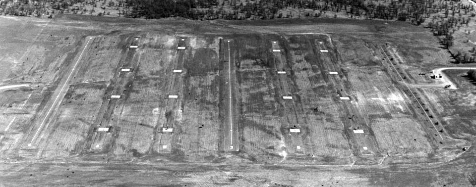
It depicted the field as having 7 paved parallel north/south strips: two 1,600' autorotation lanes, 4 approach lanes each with 4 helipads,
and a parking ramp on the east side.
Like the rest of the large number of Ft. Wolters Stage Fields, My Tho Stage Field was not depicted on aeronautical charts of the times.
My Tho Stage Field, as depicted on a 1/4/71 Army map of Fort Wolters Heliports & Stage Fields.
The date of closure of the My Tho Stage Field has not been determined,
but the helicopter training program at Fort Wolters ended in 1973.
A 2012 aerial photo showed My Tho Stage Field remained intact though deteriorated.
The site of My Tho Stage Field is located southwest of the intersection of Old River Road & Route 281.
____________________________________________________
Phu Loi Army Stage Field, Mineral Welss, TX
32.71, -98.12 (West of Fort Worth, TX)
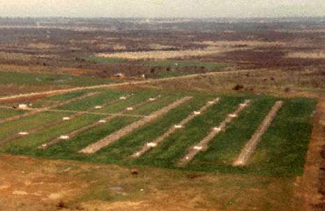
A 1966 U.S. Army aerial view looking north at Phu Loi Stage Field.
Phu Loi Stage Field was one of 25 Army outlying airfields used to support
the large-scale Army helicopter training program at Fort Wolters (several miles to the north) during the Vietnam War.
The date of construction of the Phu Loi Stage Field has not been determined,
but the helicopter training program at Fort Wolters began in 1956.
Phu Loi Stage Field was not yet depicted on the 1959 USGS topo map.
The earliest photo which has been located of the Phu Loi Stage Field was a 1966 U.S. Army aerial view.
It depicted the field as having 7 paved parallel north/south strips with multiple helicopter landing pads,
with a few small buildings on the west side.
Like the rest of the large number of Ft. Wolters Stage Fields, Phu Loi Stage Field was not depicted on aeronautical charts of the times.
Phu Loi Stage Field, as depicted on a 1/4/71 Army map of Fort Wolters Heliports & Stage Fields.
The date of closure of the Phu Loi Stage Field has not been determined,
but the helicopter training program at Fort Wolters ended in 1973.
A 2012 aerial photo showed Phu Loi Stage Field remained intact though deteriorated.
The site of Phu Loi Stage Field is located southwest of the intersection of Fairview Road & Route 281.
____________________________________________________=
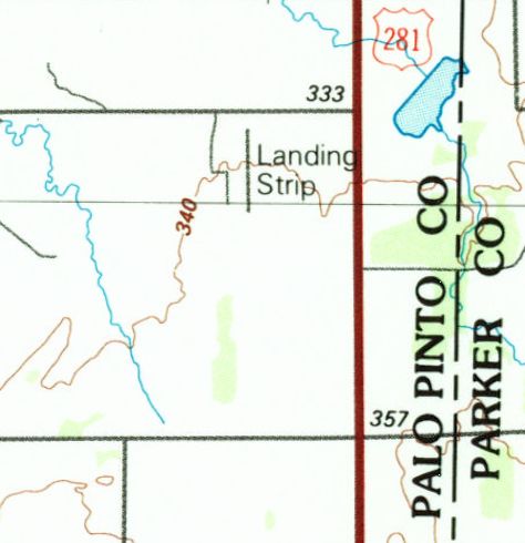
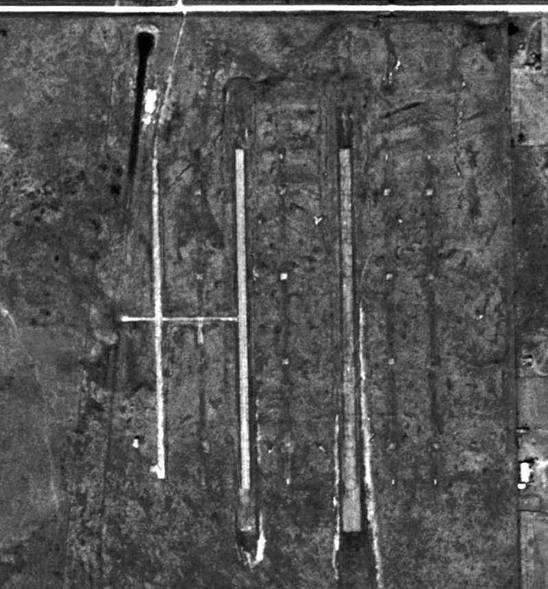
Da Nang Army Stage Field, Perrin, TX
32.99, -98.07 (West of Fort Worth, TX)
A 1966 U.S. Army aerial view looking north at Da Nang Stage Field.
This airfield was one of 25 stage fields used to support
the large-scale Army helicopter training program at Fort Wolters (several miles to the south).
The date of construction of the Da Nang Stage Field has not been determined,
but the helicopter training program at Fort Wolters began in 1956.
Da Nang Stage Field was not yet depicted on the 1959 USGS topo map.
The earliest photo which has been located of the Da Nang Stage Field was a 1966 U.S. Army aerial view.
It depicted the field as having 3 paved parallel north/south runways & 4 other rows of helicopter landing pads,
with a few small buildings on the southwest side.
Like the rest of the large number of Ft. Wolters Stage Fields, Da Nang Stage Field was not depicted on aeronautical charts of the times.
An undated photo of a portable control tower cab at Da Nang Stage Field.
A 1/4/71 Army airfield layout depicted Da Nang Stage Field
as having 3 paved parallel north/south runways & 4 other rows of helicopter landing pads,
a few small buildings on the west side, and a sod hovering area on the southwest side.
Da Nang Stage Field, as depicted on a 1/4/71 Army map of Fort Wolters Heliports & Stage Fields.
The date of closure of the Da Nang Stage Field has not been determined,
but the helicopter training program at Fort Wolters ended in 1973.
The 1985 USGS topo map depicted Da Nang Stage Field simply with 1 north/south runway labeled simply as “Landing Strip”.
A 1995 USGS aerial photo depicted Da Nang Stage Field as deteriorated but still recognizable.
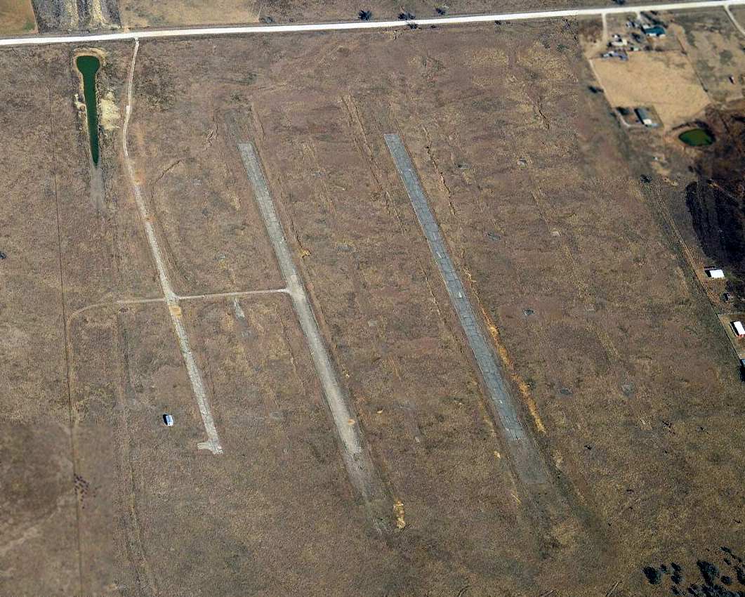
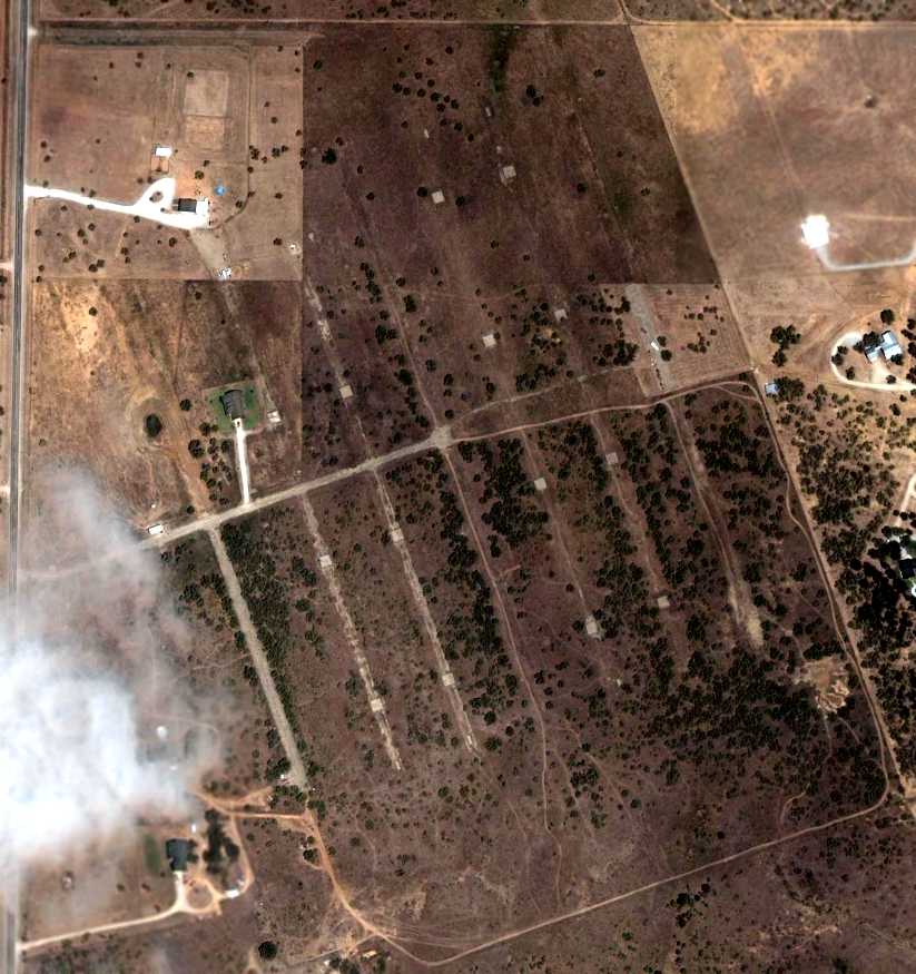
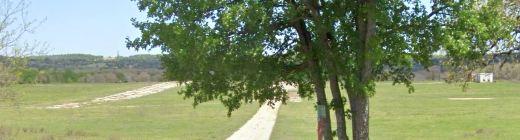
A circa 2010 aerial view looking north showed the paved landing pads of Da Nang Stage Field remained intact.

A 2012 aerial photo showed Da Nang Stage Field remained intact though deteriorated.

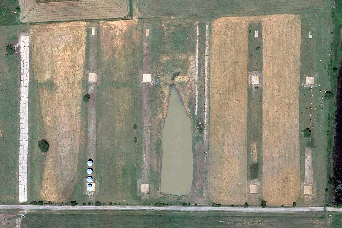
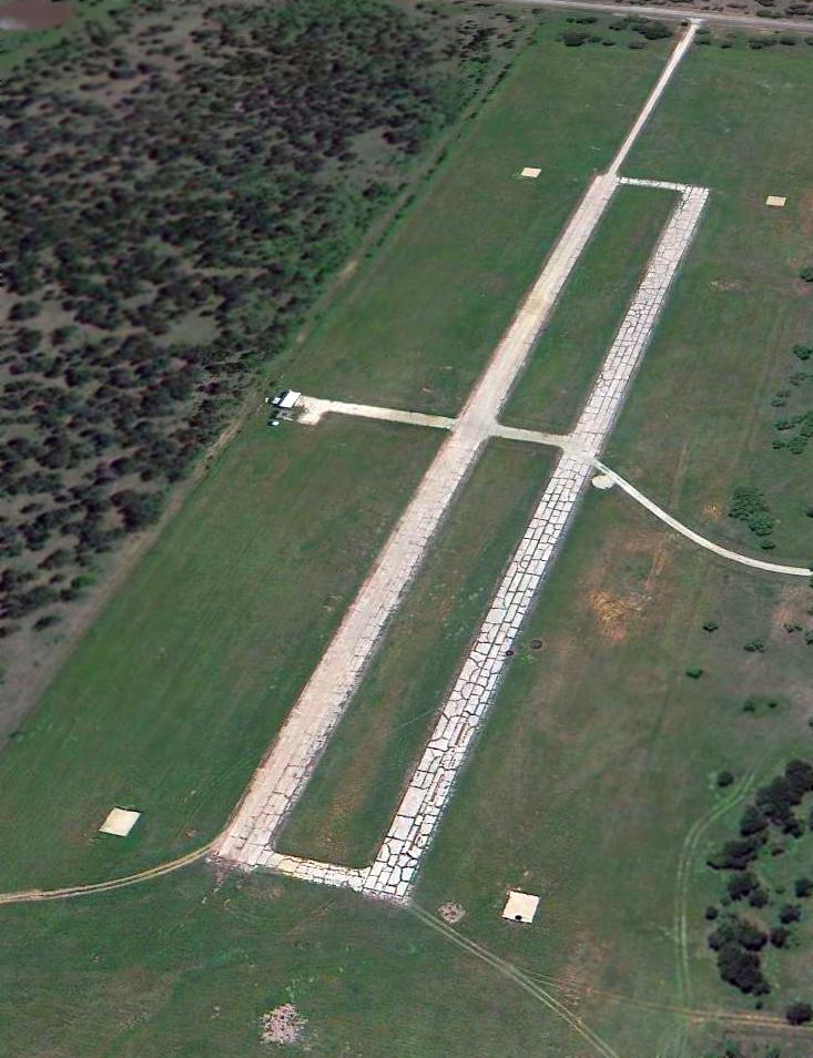
A 5/30/25 aerial view by Sierra looking northwest showed Da Nang Stage Field remained intact though deteriorated.
The site of Da Nang Stage Field is located southwest of the intersection of Rambling Road & Route 281.
____________________________________________________
Cam Ranh Army Stage Field, Weatherford, TX
32.77, -97.92 (West of Fort Worth, TX)
A 1966 U.S. Army aerial view looking north at Cam Ranh Stage Field.
This airfield was one of 25 Stage Fields used to support the large-scale Army helicopter training program at Fort Wolters (4 miles west).
The date of construction of the Cam Ranh Stage Field has not been determined,
but the helicopter training program at Fort Wolters began in 1956.
Cam Ranh Stage Field was not yet depicted on the 1959 USGS topo map.
The earliest photo which has been located of the Cam Ranh Stage Field was a 1966 U.S. Army aerial view.
It depicted the field as having a total of 6 parallel north/south paved strips & a parking apron & small building on the east side.
A 1/4/71 Army airfield layout depicted Cam Ranh Stage Field
as having 6 parallel runways, with a parking apron & small building on the east side.
Cam Ranh Stage Field, as depicted on a 1/4/71 Army map of Fort Wolters Heliports & Stage Fields.
The date of closure of the Cam Ranh Stage Field has not been determined,
but the helicopter training program at Fort Wolters ended in 1973.
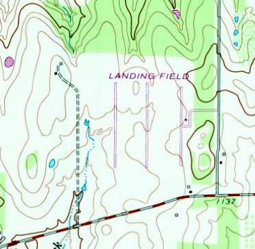
The 1979 USGS topo map depicted Cam Ranh Stage Field as a “Landing Field” with 3 parallel paved runways.
A 1995 USGS aerial photo depicted Cam Ranh Stage Field as deteriorated but still recognizable.
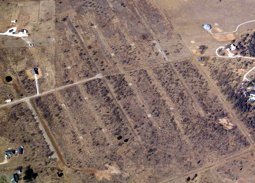
A circa 2010 aerial view looking north showed multiple helicopter landing pads of Cam Ranh Stage Field remained intact, along with the parking ramp on the east side.
A farm building had been built over the eastern portion of the airfield at some point between 1995-2010.

A 2024 aerial view looking north showed multiple helicopter landing pads of Cam Ranh Stage Field remained intact, along with the parking ramp on the east side.
The site of Cam Ranh Stage Field is located northwest of the intersection of Old Millsap Road & McCarthy Road.
____________________________________________________
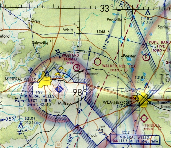
An Khe Army Stage Field / Walker Red Fox Airfield, Authon, TX
32.85, -97.96 (West of Fort Worth, TX)

A 1966 U.S. Army aerial view looking north at An Khe Stage Field.
This airfield was one of 25 stage fields used to support
the large-scale Army helicopter training program at Fort Wolters (4 miles west).
The date of construction of the An Khe Stage Field has not been determined,
but the helicopter training program at Fort Wolters began in 1956.
The earliest photo which has been located of the An Khe Stage Field was a 1966 U.S. Army aerial view.
It depicted the field as having a total of 7 north/south paved strips, all oriented north/south.
Three of the strips were configured as runways (the longest being 2,000'),
and the other 4 strips had a total of 16 helicopter landing pads.
Additionally An Khe had a field house, control tower, and connecting crash truck lanes.
A circa late-1960s Crash Rescue Map labeled this Stage Field as “An Khe”.
An Khe Stage Field, as depicted on a 1/4/71 Army map of Fort Wolters Heliports & Stage Fields.
By 1971 the An Khe Stagefield had evidently been abandoned by the Army & reused as a civil airfield,
as it was depicted as “Walker Red Fox” Airfield on the July1971 Dallas Sectional Chart (courtesy of Ron Plante), with a 1,600' unpaved runway.
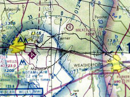
The 1978 DFW Sectional Chart (courtesy of Ray Brindle)
depicted "Walker Red Fox" as a private airfield having a 1,600' unpaved runway.
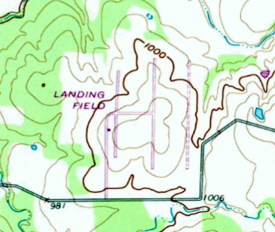
An Khe was depicted simply as "Landing Field" on the 1979 USGS topo map.
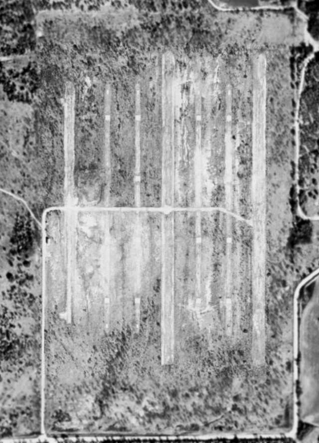
In the 1995 USGS aerial photo,
all 7 runways still existed, although some had deteriorated more than others.
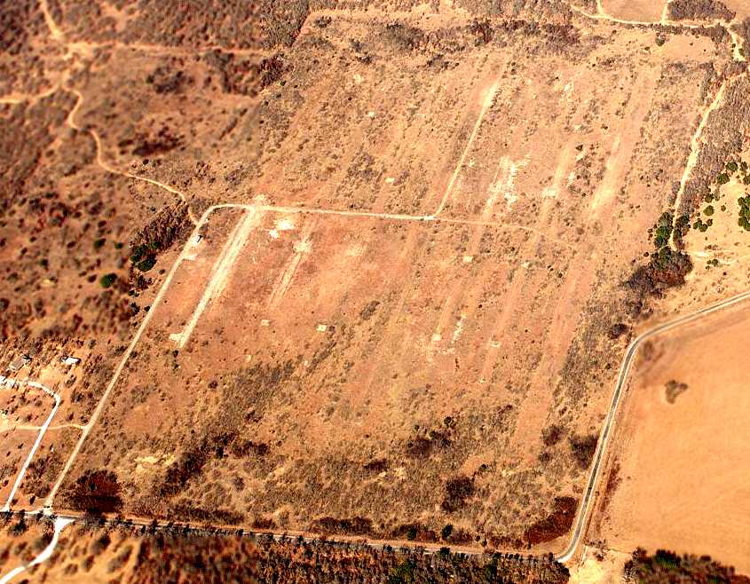
A circa 2006 aerial photo looking north at the remains of the An Khe Stage Field.
The site of An Khe Stage Field is located northwest of Garner Adell Road, one mile southwest of Authon.
____________________________________________________
Vung Tau Army Stage Field, Bennett, TX
32.7, -98.01 (West of Fort Worth, TX)
An undated aerial view looking northwest at Vung Tau Stage Field.
This airfield was one of 25 stage fields used to support
the large-scale Army helicopter training program at Fort Wolters (4 miles west).
The date of construction of the Vung Stage Field has not been determined,
but the helicopter training program at Fort Wolters began in 1956.
This field had a configuration which was very common among the numerous Ft. Wolters Stage Fields:
a total of 7 north/south paved strips, all oriented north/south.
Three of the strips were configured as runways (the longest being 2,000'),
and the other 4 strips had a total of 16 helicopter landing pads.
A circa late-1960s Crash Rescue Map labeled this Stage Field as “Vung Tau”.
Vung Tau Stage Field, as depicted on a 1/4/71 Army map of Fort Wolters Heliports & Stage Fields.
The date of closure of the Vung Tau Stage Field has not been determined,
but the helicopter training program at Fort Wolters ended in 1973.
This airfield was not depicted at all on USGS topo maps from 1973, 1983, or 1984.
The 1995 USGS aerial photo did not show any indication of recent usage.
An August 2006 view of the remains of the Vung Tau Stage Field
showed that all 7 paved strips remained in various states, with the individual helicopter landing pads standing out.
Two homes had been built over the northwest part of the site.
A circa 2010 aerial view looking north at the remains of the Vung Tau Stage Field.
The site of Vung Tau Stage Field is located east of the intersection of Route 113 & Bennett Road.
____________________________________________________
Qui Nhon Army Stage Field, Salesville, TX
32.9, -98.16 (West of Fort Worth, TX)
An 8/3/66 Army aerial photo looking northwest at Qui Nhon Stage Field (courtesy of Chris Ness, who soloed from Qui Nhon).
This airfield was one of 25 stage fields used to support
the large-scale Army helicopter training program at Fort Wolters (7 miles to the east).
The specific dates of Army use of the Qui Nhon Stage Field are unknown,
but the helicopter training program at Fort Wolters operated from 1956-73.
The Qui Nhon Stage Field was not yet depicted on the July 1966 USGS topo map (courtesy of Chris Ness).
The earliest depiction of the Qui Nhon Stage Field which has been located
was an 8/3/66 Army aerial photo (courtesy of Chris Ness).
The airfield at Qui Nhon had a configuration which was fairly common to the Fort Wolters Stage Fields.
In particular, Qui Nhon had 2 paved 1,700' runways,
and 4 other rows of paved helicopter landing spots, all arranged in parallel.
A circa late-1960s Crash Rescue Map labeled this Stage Field as “Qui Nhon”.
Qhi Nhon Stage Field, as depicted on a 1/4/71 Army map of Fort Wolters Heliports & Stage Fields.
The helicopter training program at Fort Wolters ended in 1973, presumably ending use of Qui Nhon Stage Field.
The Qui Nhon Stage Field was not depicted at all on the July 1973 DFW Sectional Chart nor on the 1973 USGS topo map.
A 6/4/77 USGS aerial photo showed the abandoned Qui Nhon Stage Field.
As seen in the 1995 USGS aerial photo,
the western-most runway still remained in the best condition,
while it appears as if the pavement of the middle runway had been removed at some point.
The other rows of individual paved helicopter landing spots still remained as well.
A circa 2006 aerial view looking north at the remains of Qui Nhon State Field shows that it has deteriorated considerably compared to the 1995 photo.
The Qui Nhon Stage Field is located 3 miles south of the intersection of Route 254 & Route 52.
____________________________________________________
Fort Wolters Stage Field #6 / Bronco Stage Field, Garner, TX
32.91, -97.98 (West of Fort Worth, TX)
A 1966 U.S. Army aerial view looking north at Fort Wolters Stage Field #6.
Fort Wolters Stage Field #6 / Bronco Stage Field was one of 25 stage fields used to support
the large-scale Army helicopter training program at Fort Wolters (5 miles to the southwest).
The date of construction of Fort Wolters Stage Field #6 has not been determined,
but the helicopter training program at Fort Wolters began in 1956.
The earliest depiction of this field which has been located was a 1966 U.S. Army aerial view.
Stage Field #6 had a configuration which was fairly common to the Fort Wolters Stage Fields:
a set of 7 rectangular paved strips arranged in parallel, oriented north/south.
Two of the strips were configured as runways,
and the other 5 strips had a large number of individual helicopter landing spots.
A circa 1960s airfield layout of Fort Wolters Stage Field #6 / Bronco
showed the Parking Apron on the northeast, a Hovering Apron on the southeast, and 2 parallel runways & 4 rows of landing pads on the west.
The date of closure of Fort Wolters Stage Field #6 / Bronco Stage Field has not been determined,
but the helicopter training program at Fort Wolters ended in 1973.
Bronco Stage Field was not depicted at all on the July 1973 DFW Sectional Chart
or on USGS topo maps from 1973, 1983, or 1984.
USGS aerial photo 1995.
A December 19, 2003 photo by Scott Murdock looking southwest at the former control tower at the site of Bronco Stage Field.
A December 19, 2003 photo by Scott Murdock looking south along a runway toward the former control tower at the site of Bronco Stage Field.
A circa 2006 aerial photo looking northwest at the remains of the Bronco Stage Field.
Bronco Stage Field is located northwest of the intersection of Route 113 & New Authon Road.
____________________________________________________
33.04, -98.25 (West of Fort Worth, TX)
Hue Stage Field, as depicted on a circa late-1960s Fort Wolters Crash Rescue Map.
Photo of the airfield while in use has not been located.
Hue Stage Field was one of 25 stage fields used to support
the large-scale Army helicopter training program at Fort Wolters (5 miles to the southwest).
The date of construction of Hue Stage Field has not been determined,
but the helicopter training program at Fort Wolters began in 1956.
The earliest depiction of Hue Stage Field which has been located
was on a circa late-1960s Fort Wolters Crash Rescue Map.
The date of closure of Hue Stage Field has not been determined,
but the helicopter training program at Fort Wolters ended in 1973.
Hue Stage Field was not depicted at all on the July 1973 DFW Sectional Chart.
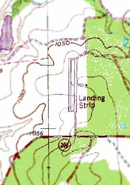
Hue Stage Field was labeled simply as “Landing Strip” on the 1981 USGS topo map.
It depicted 2 parallel paved runways.
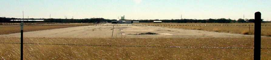
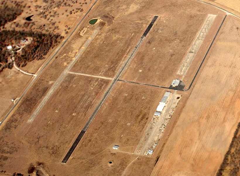
A 4/16/12 aerial view looking southeast showed the paved runway surfaces & 4 square landing pads
remained intact though deteriorated at the site of Hue Stage Field.
A 2023 photo looking north at the paved runway remains & square landing pads at the site of Hue Stage Field.
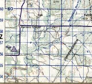
Hue Stage Field is located southwest of the intersection of Bartons Chapel Road & Route 4.
Thanks to Chris Kennedy for determining the location of this field.
____________________________________________________
Or if you prefer to contact me directly concerning a contribution (for a mailing address to send a check),
please contact me at: paulandterryfreeman@gmail.com
If you enjoy this web site, please support it with a financial contribution.
____________________________________________________
This site covers airfields in all 50 states.