
Abandoned & Little-Known Airfields:
Texas, Western Abilene area
© 2002, © 2026 by Paul Freeman. Revised 2/22/26.
This site covers airfields in all 50 states: Click here for the site's main menu.
____________________________________________________
Please consider a financial contribution to support the continued growth & operation of this site.
Butterfield Trail Airport (revised 9/20/16) - D-Bar Ranch Airfield (revised 1/4/22) - Goodfellow AFB (revised 2/22/26)
Goodfellow Army Airfield Aux #2 / Broome Field (added 3/27/20) - Goodfellow Aux AAF #6 / Vancourt Field (revised 9/24/17)
Maker Field / Hughes Airport (revised 12/1/23) - Victory Field (revised 1/17/22)
____________________________________________________
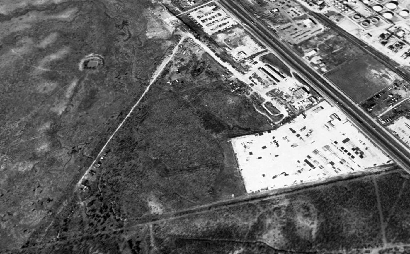
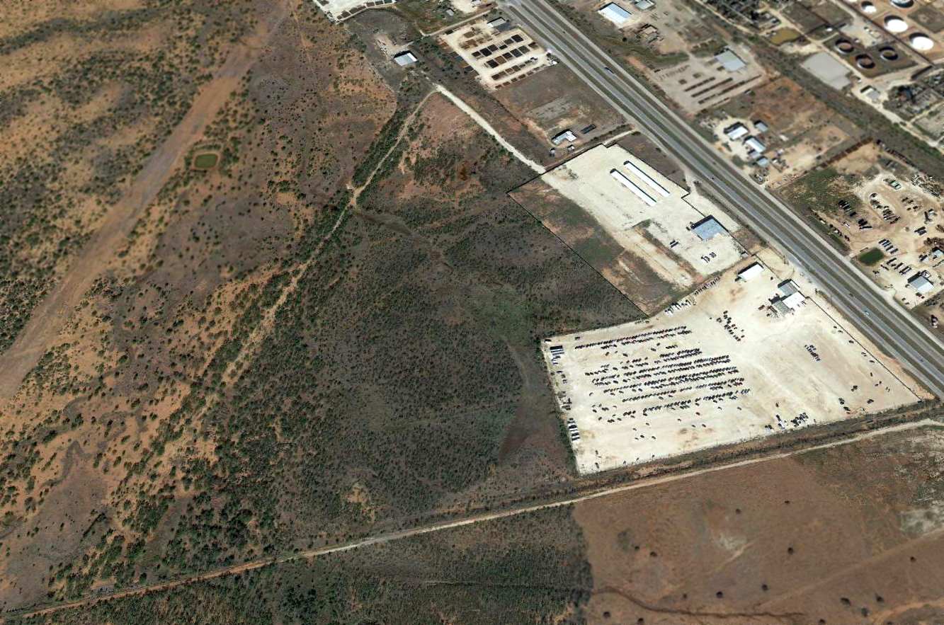
Goodfellow Army Airfield Aux #2 / Broome Field, San Angelo, TX
31.323, -100.424 (West of Austin, TX)
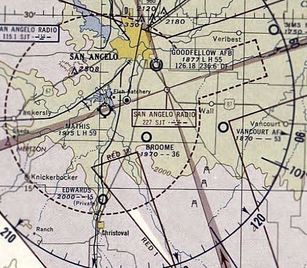
Broome Field, as depicted on the September 1944 Austin Sectional Chart.
Broome Field was evidently built at some point between 1942-44,
as it was not yet depicted on the June 1942 Austin Sectional Chart.
It was built as one of 7 satellite airfields which supported pilot training at Goodfellow Army Airfield.
The earliest depiction which has been located of Broome Field was on the September 1944 Austin Sectional Chart.
Broome Field was evidently reused as a civilian airfield after WW2.
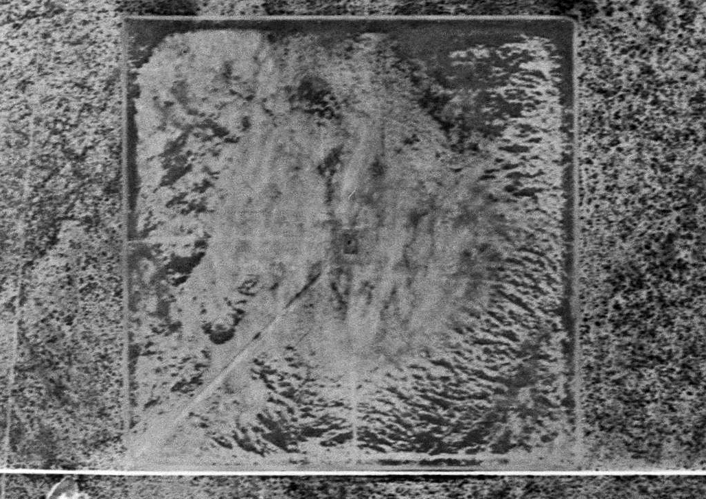
The earliest photo which has been located of Broome Field was a 5/4/54 aerial view (courtesy of Bob Morris).
It was depicted as a 3,600' square unpaved airfield.
There were no aircraft or buildings visible on the field.
The last aeronautical chart depiction which has been located of Broome Field was on the March 1956 Austin Sectional Chart.
It depicted Broome Field as having a 3,600' unpaved runway.
Broome Field was evidently closed (for reasons unknown) at some point in 1956,
as it was no longer depicted on the September 1956 Austin Sectional Chart.
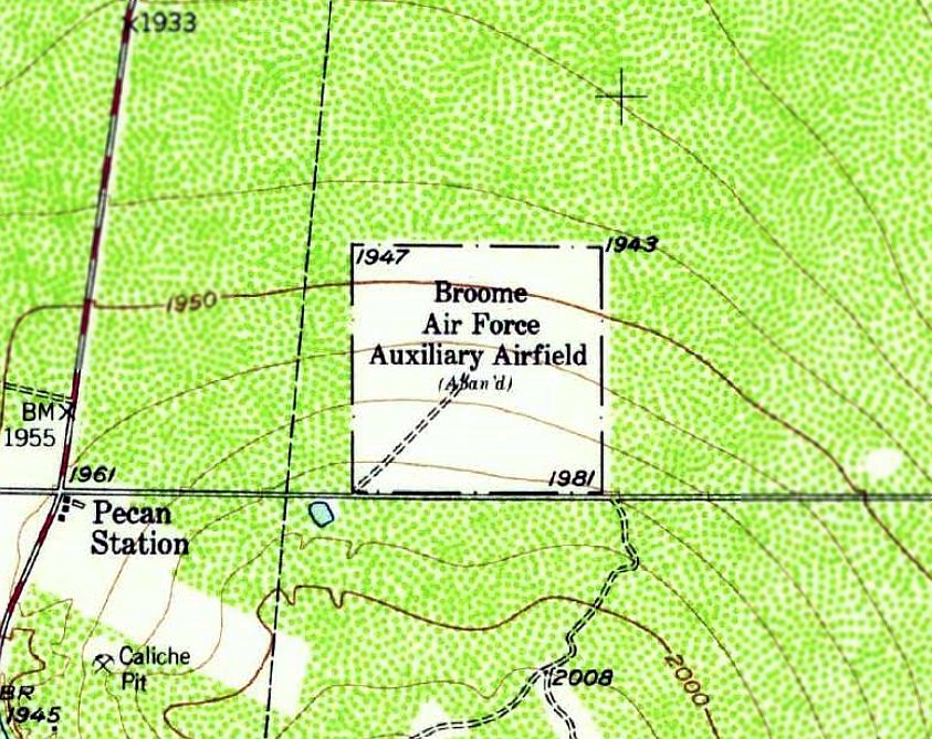
The 1957 USGS topo map (courtesy of Bob Morris) depicted “Broome Air Force Auxiliary Airfield (Abandoned)” as a 3,600' square.
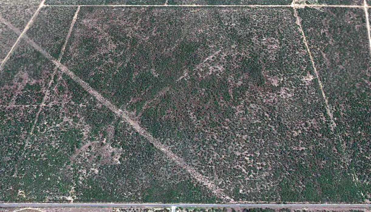
A 2018 aerial view looking north at the remains of Broome field showed the square airfield perimeter to remain recognizable.
Thanks to Bob Morris for pointing out this airfield.
____________________________________________________
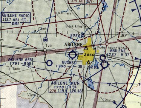
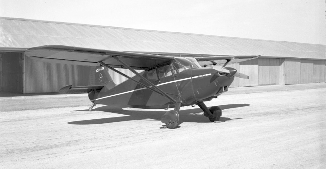
Maker Field / Hughes Airport, Abilene, TX
32.45, -99.78 (Southwest of Fort Worth, TX)
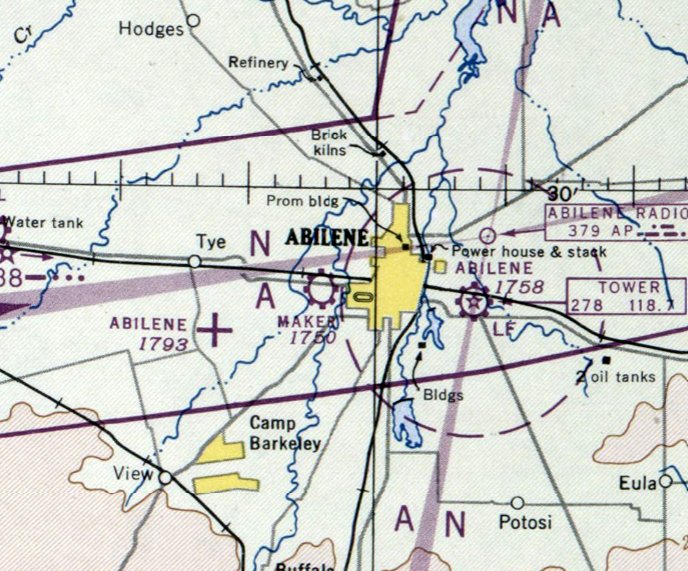
Maker Field, as depicted on the March 1947 Dallas Sectional Chart.
According to the 5/25/10 Clack Middle School Chronicle (courtesy of Mark Williams),
Maker Field was established after WW2 by former military flight instructors Red Maker & his brother-in-law Lester.
They came to Abilene in 1945, and lived at the airport for a year or so.
Maker Field was not yet depicted on the September 1946 Dallas Sectional Chart.
The earliest depiction which has been located of Maker Field was on the March 1947 Dallas Sectional Chart.
It depicted Maker Field as a commercial/municipal airport.
The February 1950 Dallas Sectional Chart depicted Maker Field as having a 3,000' unpaved runway.
In 1950 or 1951, local businessman Jack Hughes wanted to buy the Maker Field property to put up a shopping center.
He ran the airport for a short period of time, renaming it Hughes Airport.
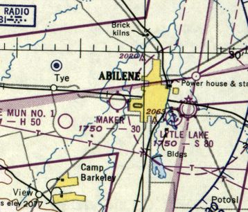
Hughes Airport, as depicted on the 1954 USGS topo map.
The earliest photo which has been located of Hughes Airport was an 11/19/54 USGS aerial view.
It depicted Hughes as having 3 unpaved runways, with a few small hangars on the northeast side.
No aircraft were visible on the field.
According to the 5/25/10 Clack Middle School Chronicle (courtesy of Mark Williams), Earl Outland ran the Hughes Airport.
Don Bledsoe learned to fly at Hughes, and became a lineman at the airport.
The field had a main hangar, sales office, T-hangars, and over 100 planes.
The field featured fly-outs, hangar parties, and flying shopping excursions.
Jack North remembered flying out of Hughes Airport several times.
The last aeronautical chart depiction which has been located of Hughes Field was on the February 1955 Dallas Sectional Chart.
It depicted Hughes Field as having a 3,000' unpaved runway.
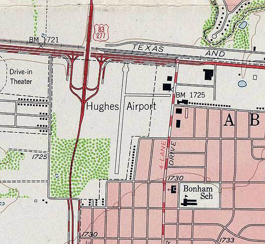
The 1957 USGS topo map (courtesy of Mark Williams) depicted Hughes Airport as having a north/south paved runway with a taxiway leading to 2 buildings on the northeast side.
The 2 other runways depicted in 1954 had been lost, as the airport property had been reduced by the construction of Route 83 along the west side.
The construction of the bypass at Loop 322 & South 1st was a factor against the longevity of Hughes Airport.
Hughes Airport was evidently closed at some point between 1957-60,
as it was no longer depicted on the August 1960 Dallas Sectional Chart.
Jack Hughes opened the Westgate Shopping Capital on the Hughes Airport property in 1962.
The 1968 USGS topo map depicted the shopping center covering the Hughes Airport property.
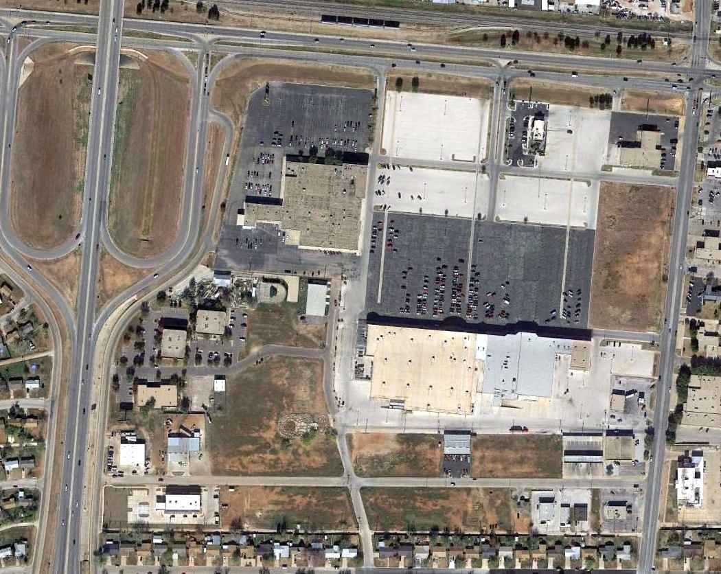
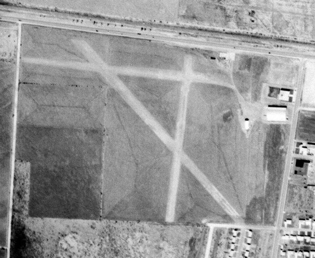
A 12/9/12 aerial view showed no trace remaining of Hughes Airport.
The site of Hughes Airport is located southeast of the intersection of South 1st Street & Route 277.
Thanks to Mark Williams for pointing out this airfield.
____________________________________________________
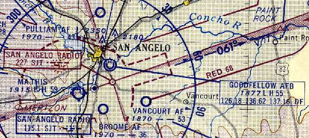
Goodfellow AAF / Goodfellow AFB, San Angelo, TX
31.43, -100.41 (Southwest of Fort Worth, TX)
The airfield which would eventually become Goodfellow AAF was depicted (but not specifically labeled)
on the 1941 Austin Sectional Chart (courtesy of Chris Kennedy).
Goodfellow Field was evidently constructed at some point between 1940-41,
as it was not yet depicted on the August 1940 Austin Sectional Chart.
The earliest depiction which has been located of Goodfellow Field was on the 1941 Austin Sectional Chart (courtesy of Chris Kennedy).
It depicted Goodfellow Field (as an unlabeled military airfield) just northwest of the predecessor "San Angelo" civilian airport.
According to the Goodfellow AFB website, military flight operations at Goodfellow Field began in February 1941,
when the first class of Army Air Corps students arrived to take basic flying training.
Primary & basic flight training was provided at Goodfellow for American & foreign cadets.
The North American BT-9/14 Yale & Vultee BT-15 Valiant were used at Goodfellow in 1941.
Goodfellow AAF consisted of a total of 1,137 acres.
A rare color photograph of a Vultee BT-13 Valiant at Goodfellow Field in 1941.
The BT-13 Valiant was used at Goodfellow from 1941-45.
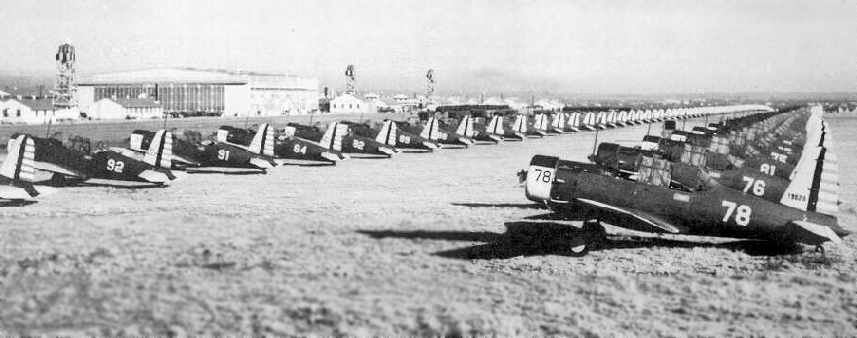
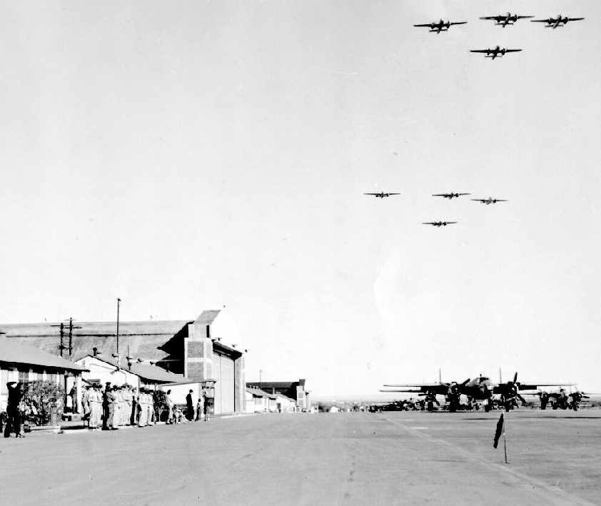
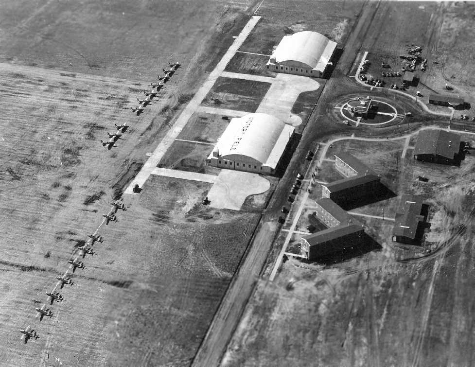
A 1942 photo of a huge number of BT-13 Valiants on the flight line at Goodfellow Field.
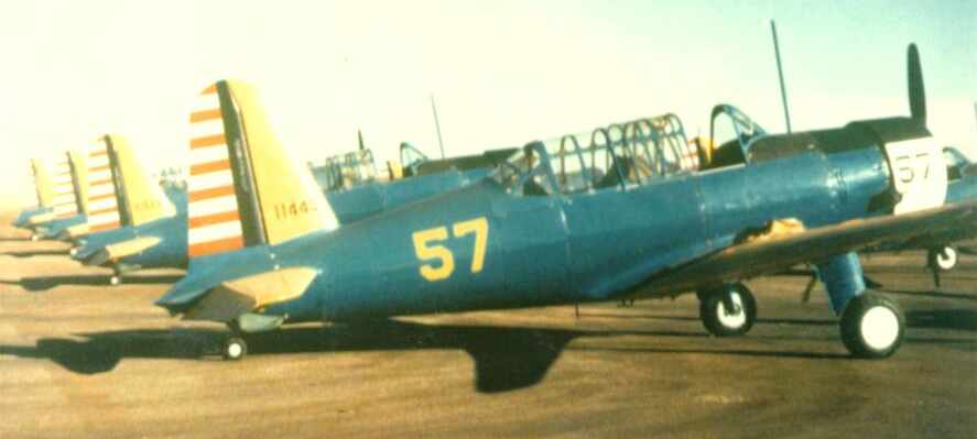
A WW2 photo of North American AT-6 Texan trainers at Goodfellow Field (courtesy of William Womack).
A WW2 aerial view of Goodfellow Field (courtesy of William Womack).
A WW2 photo of North American AT-6 Texan trainers at Goodfellow Field (courtesy of William Womack).
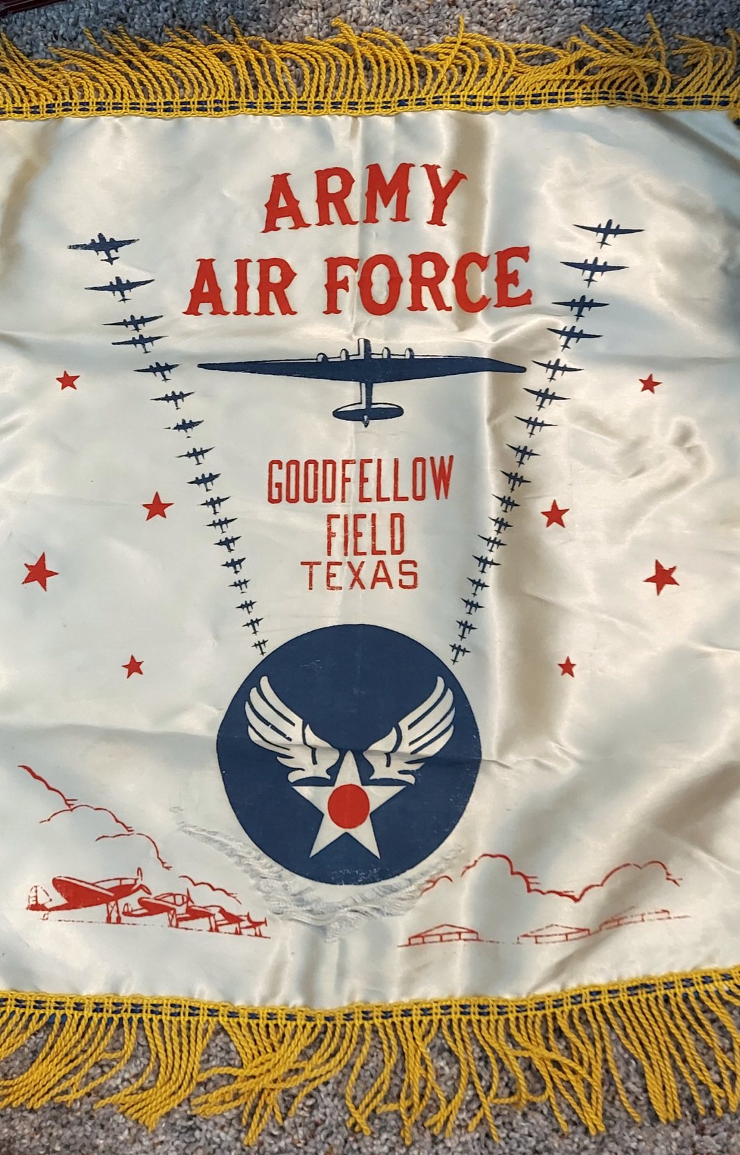
A WW2 scarf from Goodfellow Field (courtesy of William Womack).
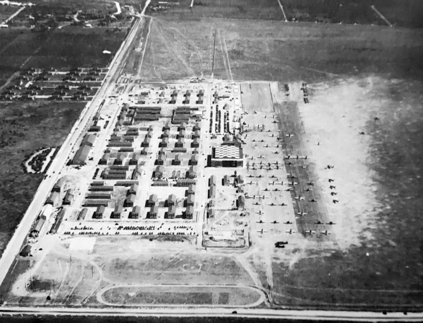
A 1943 aerial view looking east at Goodfellow Field.
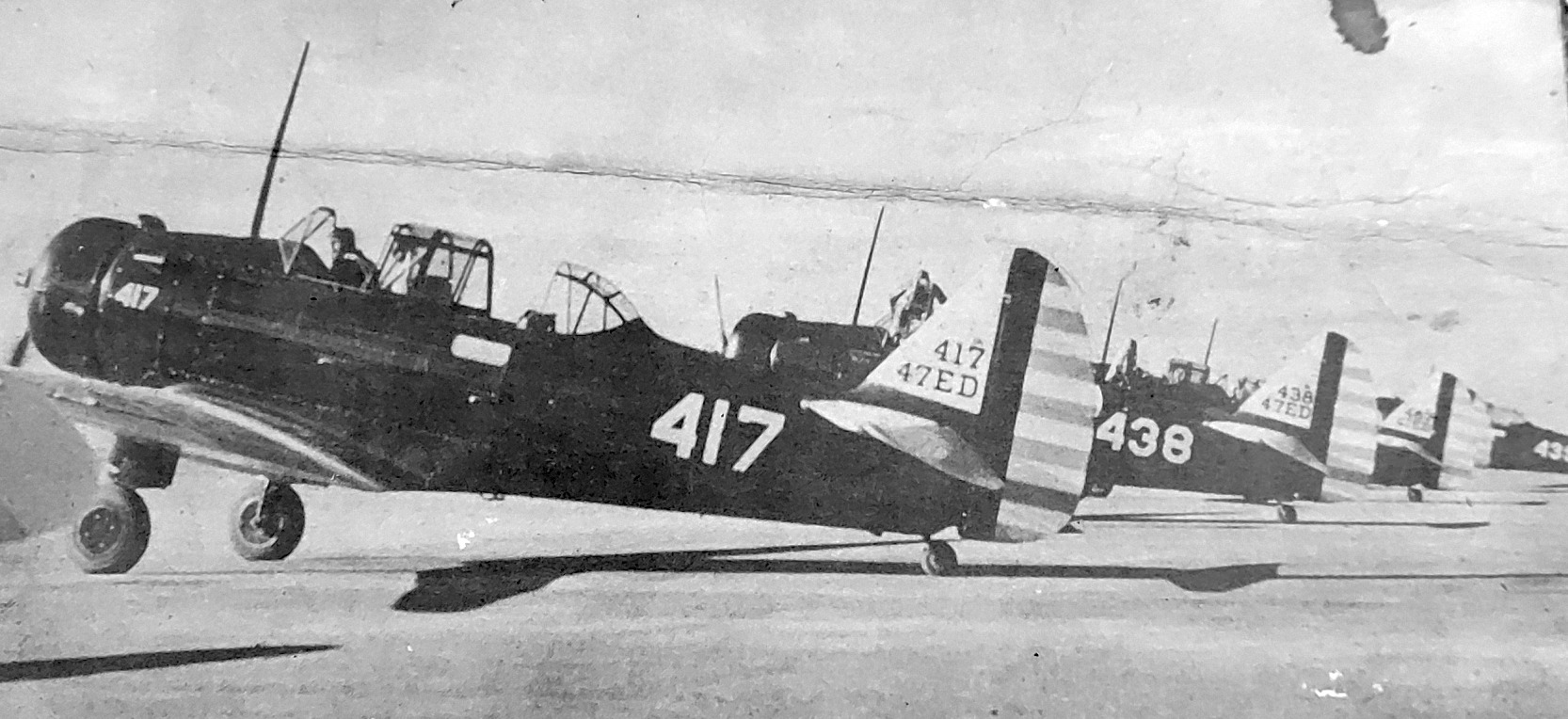
A 5/15/43 AAF list of airfields of the Gulf Coast Training Center (courtesy of Ron Plante)
described Goodfellow Field as having 3 asphalt runways, with the longest being the 5,500' northeast/southwest & northwest/southeast strips.
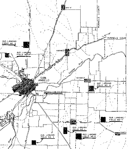
It listed Goodfellow as having 7 satellite fields (all unpaved):
Oates Aux #1 (9.3 miles southeast of San Angelo),
Broome Aux #2 (10 miles SSE of San Angelo),
Robbins Aux #3 (7 miles NNW of San Angelo),
Lane Aux #4 (10 miles ESE of San Angelo),
Pullium Aux #5 (2 miles northwest of Pullium),
Vancourt Aux #6 (1.5 miles southwest of Vancourt),
and Wall Aux #7 (3 miles ESE of Wall).
The Fairchild PT-19 Cornell primary trainer was used at Goodfellow from 1944-45,
while the Stearman-Boeing PT-13/17 Kaydet primary trainer biplane was used from 1944-46.
The North American AT-6/T-6 Texan Basic/Primary Trainer was used at Goodfellow from 1944-54.
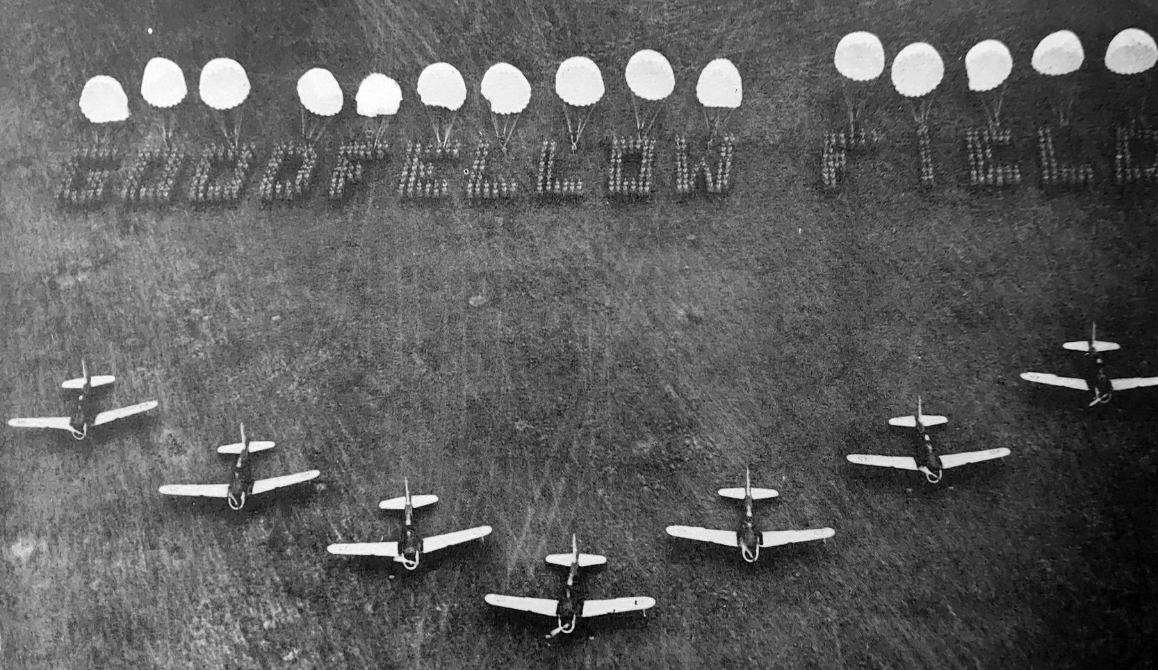
The satellite fields surrounding Goodfellow AAF.
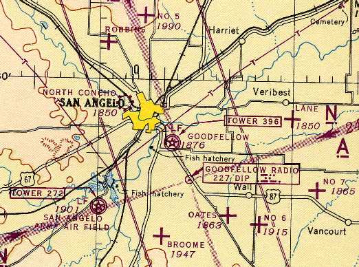
Goodfellow AAF & its satellite fields, as depicted on the 1945 Austin Sectional Chart (courtesy of Chris Kennedy).
The Beechcraft AT-11 Kansan, North American P-51 Mustang, and North American B-25 Mitchell all served at Goodfellow from 1945-46.
Goodfellow trained a total of 10,000 airmen during the Second World War.
Goodfellow AAF was retained after WW2.
The Douglas C-47 Skytrain was used at Goodfellow from 1946-71.
Following the creation of the independent U.S. Air Force in 1948, Goodfellow AAF became Goodfellow Air Force Base, an installation of the Air Training Command.
Goodfellow AFB was depicted on the 1949 Austin Sectional Chart (courtesy of Chris Kennedy) as having a 5,500' hard-surface runway.
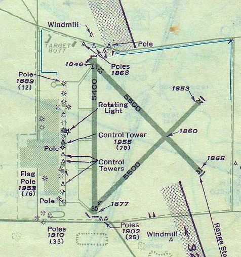
A 1951 approach plate (courtesy of John Price) depicted Goodfellow AAF as having 3 paved runways, with the longest being 5,500'.
A ramp, hangars, and control tower were depicted on the west side of the airfield.
The Beechcraft C-45 Expediter was used at Goodfellow from 1951-54.
Goodfellow was host to a test program (a competitive flyoff?) in 1951-52, using the Beechcraft YT-34 Mentor & the TEMCO YT-35 Buckaroo.
The Beechcraft AT-7/T7BH Navigator Basic Trainer was used at Goodfellow in 1952.
The Aeronca L-16 was used at Goodfellow from 1952-53, while the Piper L-21 Super Cub was used from 1952-54.
The North American T-28 Trojan Basic Trainer was used at Goodfellow from 1953-55.
The North American B-25 Mitchell returned to service at Goodfellow from 1954-58.
Goodfellow AAF & its satellite fields, as depicted on the 1954 Edward's Plateau World Aeronautical Chart (courtesy of Chris Kennedy).

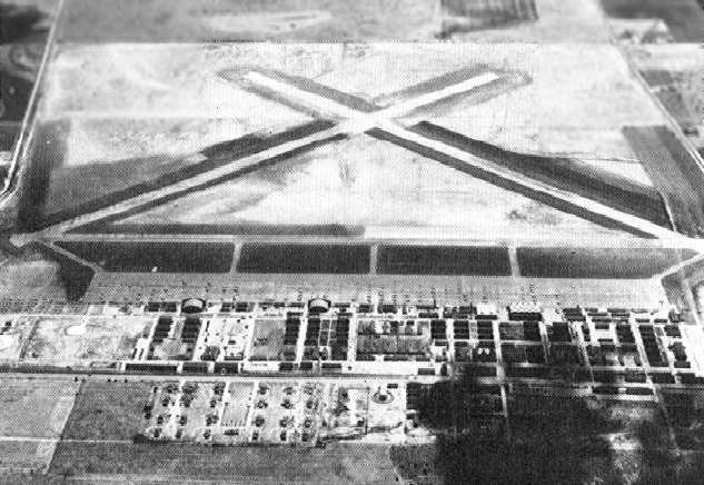
A 10/20/54 USGS aerial view depicted Goodfellow AFB as having 3 paved runways & a huge number of aircraft filling its ramp.
The first jet aircraft to be assigned to Goodfellow was the Lockheed T-33 Shooting Star,
which was used in a test program from 1956-57.
The Cessna U-3 Administrator was used at Goodfellow from 1958-71,
while the Piasecki H-2 Workhorse helicopter was used for weather missions from 1958-66.
Goodfellow continued to offer flight training until 1958, at which point it had trained a total of 20,000 aviators.
Goodfellow was transferred to the USAF Security Service, and its new mission became the training of Air Force personnel in advanced cryptologic skills.
The base's mission eventually expanded to include joint-service training in these same skills for Army, Navy, and Marine Corps personnel.
The DeHavilland U-6 Beaver was used for weather missions at Goodfellow from 1960-66.
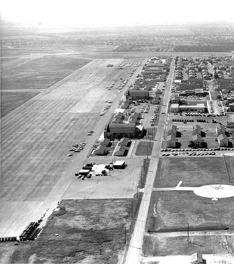
A 1966 aerial view looking south showed cars along along Goodfellow's ramp but no planes.
The last aeronautical chart depiction which has been located showing the Goodfellow AFB runways open was on the November 1967 Austin Sectional Chart.

The last photo which has been located showing Goodfellow AFB while it was still open was a 3/2/72 USGS aerial view.
Only Runway 17/35 was still marked as open, but there were no aircraft visible on the ramp.
The last aircraft to be permanently assigned to Goodfellow AFB was the Cessna O-2 Super Skymaster,
which served from 1972-75, at which point the last 2 examples were transferred.
Goodfellow's runways were permanently closed in March 1975.
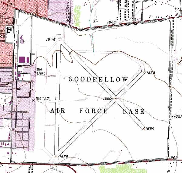
The 1978 USGS topo map still depicted Goodfellow AFB's 3 paved runways, ramp, and hangars.
Occasional flying operations were conducted into Goodfellow in the early 1980s
by C-130s participating in Readiness Loading Program activities.
Mark Williams recalled, “Goodfellow AFB... I was stationed there from April-August 1983.
While there I started taking my private pilot's course with the base flying club, and flew from the then-closed runways enough to get just over 20 hours.
My instructor was an active duty, USAF Lt. Col., and the base chaplain!
God may not have been my co-pilot, but I had the next best thing!
My last flight there was rather eventful, or I should say the landing was.
At the time they were just beginning the construction which resulted in what we see at Goodfellow today.
We frequently had to coordinate our takeoffs, and landings to avoid heavy construction equipment on the runways,
but generally they were done for the day when started our flying in the early, West Texas summer evenings.
This particular flight was spent shooting approaches at San Angelo's Mathis Field, and when we finished flew back to Goodfellow.
It was going to be 'my' landing, but on very short final a road grater drove onto the runway.
My instructor first told me to go around, then stated he had the aircraft.
I gave the controls to him, and acknowledged that it was 'his' aircraft.
He extended the final flying over the grater, then landed ('Geez, Chaplain!').
Just as he started to slow the aircraft we experienced quite a jolt. and he literally hollered at me, 'Did you touch the brakes?!'
No sir, I said, and it the became quite apparent that we blew a main tire.
He was able to safely bring the aircraft to a stop on the runway, and when we examined the tire we discovered that we had run over quite a large nail.
A man with the construction company drove over to us in his pickup, asked if we were okay, then drove us back to our hangar.
That was my last flight as a student at Goodfellow AFB. It was late July, 1983.
When I left Goodfellow in August the flying club was still there, and still using the runway, so I am not certain when they finally stopped using the field.”
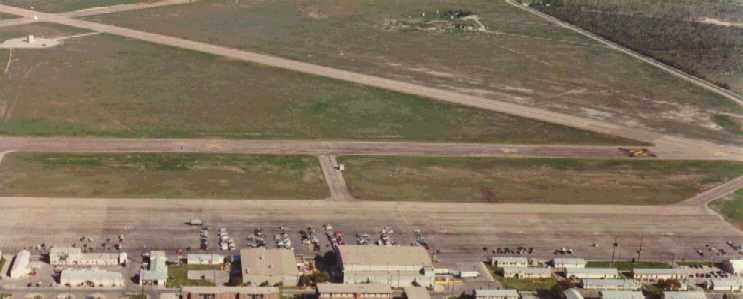
Ramp & runways at Goodfellow in 1985, after runways had been closed.
One of the large circa 1940s hangars at Goodfellow was razed in the late 1980s to make way for a new Commissary & Base Exchange.
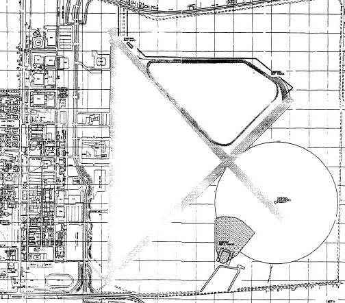
Goodfellow's airfield layout, from a 1989 Environmental Impact Report (courtesy of Rex Ricks).
The very last aircraft to operate from the runways at Goodfellow were 2 C-130s
which landed in June 1990 to support the fire-protection training mission realigning from Chanute AFB.
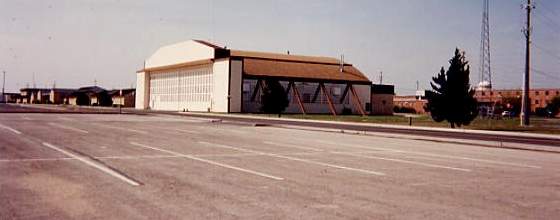
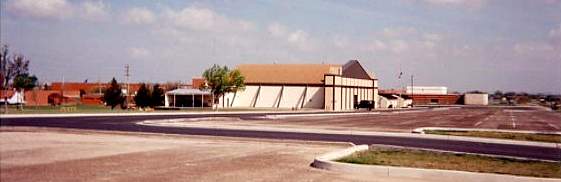
Two 1994 photos by Scott Murdock of 2 former hangars which remained standing at Goodfellow AFB.

A 1996 USGS aerial view looking east at Goodfellow AFB, showing the remains of the 3 runways.
As of 2003, Goodfellow remains open as an active military base, although without any flight operations.
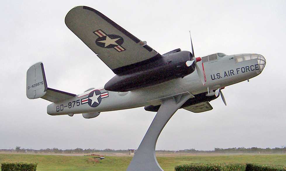
A 11/8/03 photo by Brian Johnstone of a North American B-25J Mitchell mounted as a gate guard at Goodfellow.
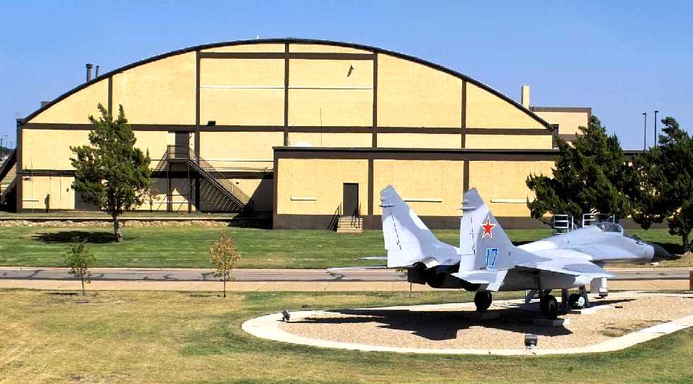
What an ironic sight, only a few years after the end of the Cold War:
a 2005 photo of a once-feared Soviet Air Force MiG-29 Fulcrum A, on static display behind a Goodfellow AFB hangar.
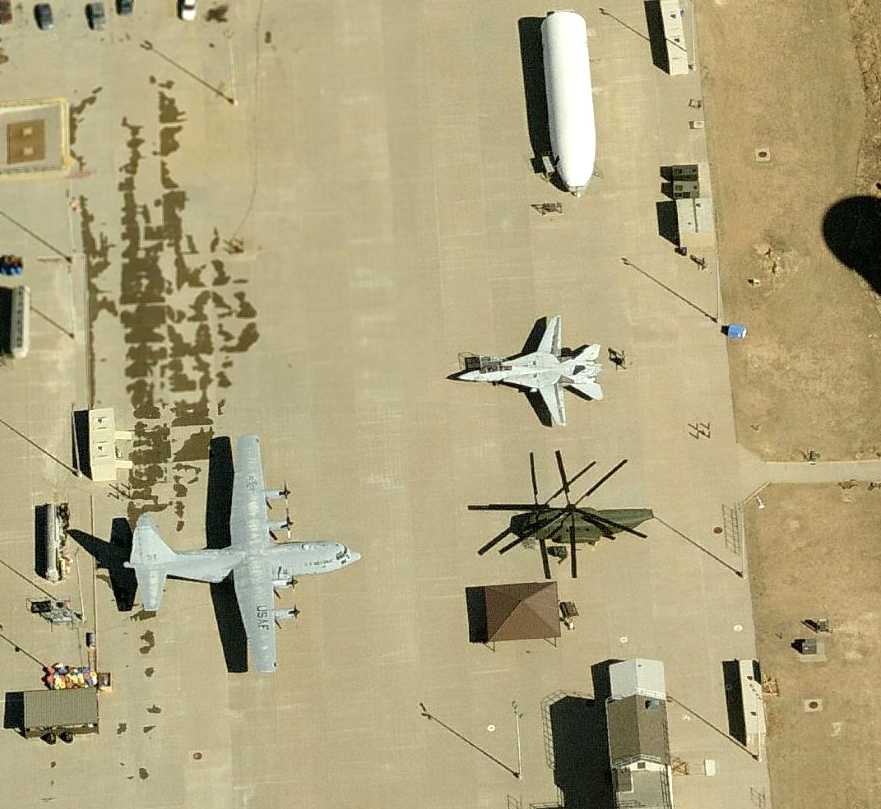
A circa 2006 aerial view looking north at an unusual collection of retired aircraft on Goodfellow's ramp:
a C-130 Hercules, F-14 Tomcat, and CH-53 Sea Stallion (sans no tail & tail rotor).
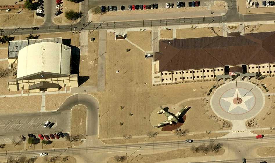
A circa 2007 aerial view looking west at a former Goodfellow hangar, a C-47 on static display, and the former Wing headquarters building.
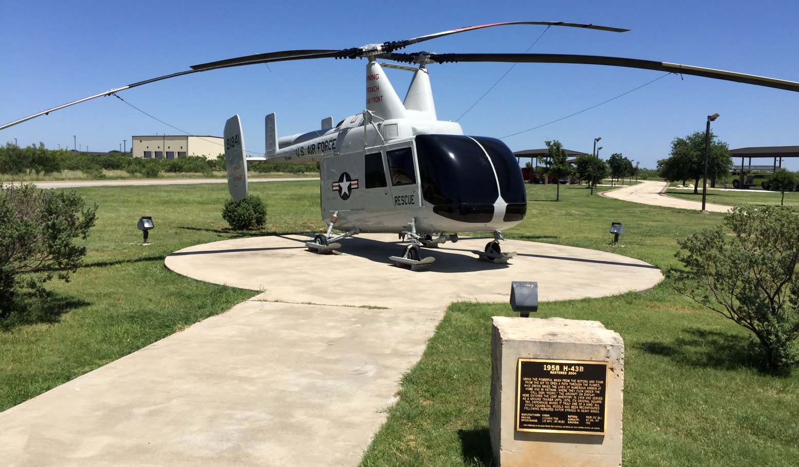
A 7/15/15 photo of a Kaman H-53 Huskie rescue helicopter on static display at Goodfellow AFB.

A 2025 aerial view looking east at Goodfellow AFB, showing the remains of the 3 runways.

A 2025 aerial view of the unusual collection of retired aircraft on Goodfellow's ramp: an F-16, H-60, F-14, and 2 C-130s.
William Womack reported in 2022 that the former Goodfellow hangar south of the former Wing headquarters building “is now a gym.”
See also: The Handbook of TX Online.
____________________________________________________
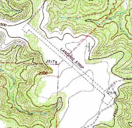
Goodfellow Army Airfield Aux #6 / Vancourt Field, Wall, TX
31.34, -100.29 (West of Austin, TX)
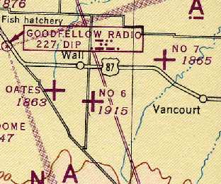
Vancourt was simply labeled as "No 6" on the 1945 Austin Sectional Chart (courtesy of Chris Kennedy).
Vancourt Field was evidently built at some point between 1941-43,
as it was not yet depicted at all on the 1941 Austin Sectional Chart (according to Chris Kennedy).
Vancourt Field was reportedly operational by 1943.
It was built as one of 7 satellite airfields which supported pilot training at Goodfellow Army Airfield.
A 5/15/43 AAF list of airfields of the Gulf Coast Training Center (courtesy of Ron Plante)
listed Goodfellow Auxiliary #6 but did not specify its runway configuration.
Vancourt Field was declared surplus with the end of WW2 in 1945.
Unlike many other WW2-era auxiliary military airfields, Vancourt was returned to active service in 1948.
"Vancourt AF" was depicted on the 1949 Austin Sectional Chart (courtesy of Chris Kennedy)
as having a 5,300' unpaved runway.

"Vancourt AF" was depicted on the 1954 Edward's Plateau World Aeronautical Chart (courtesy of Chris Kennedy)
as having a 5,300' unpaved runway.
A 11/6/54 USGS aerial photo showed Vancourt equipped with 3 paved runways,
in contrast to earlier depictions of it having only unpaved runways.
Vancourt may have been the only one of Goodfellow's 7 satellite fields to be improved with paved runways,
to support training of B-25 Mitchell bomber crews.
Thus it became the only one of Goodfellow's satellite fields of which any trace still exists.
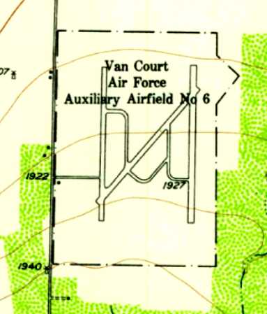
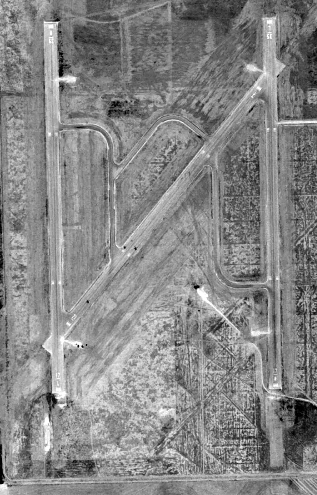
The 1957 USGS topo map depicted “Van Court Air Force Auxiliary Airfield #6” as having 3 paved runways & taxiways.
Vancourt was transferred from the control of Goodfellow AFB to Webb AFB in 1958,
until it was closed by the Air Force in 1961.
The Vancourt airfield was no longer depicted at all
on the 1961 Edward's Plateau World Aeronautical Chart (according to Chris Kennedy).
Joe Prouse recalled, the “airfield south of Wall... Back in the 1960s & 1970s I raced motorcycles on it.
I was told that it was WW2 training base, but I never knew its name.”
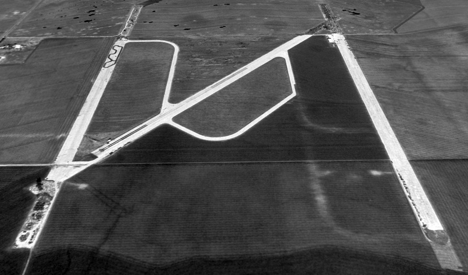
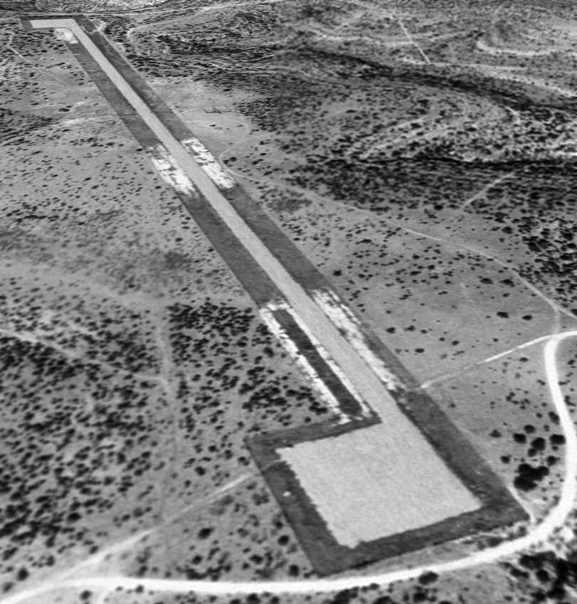
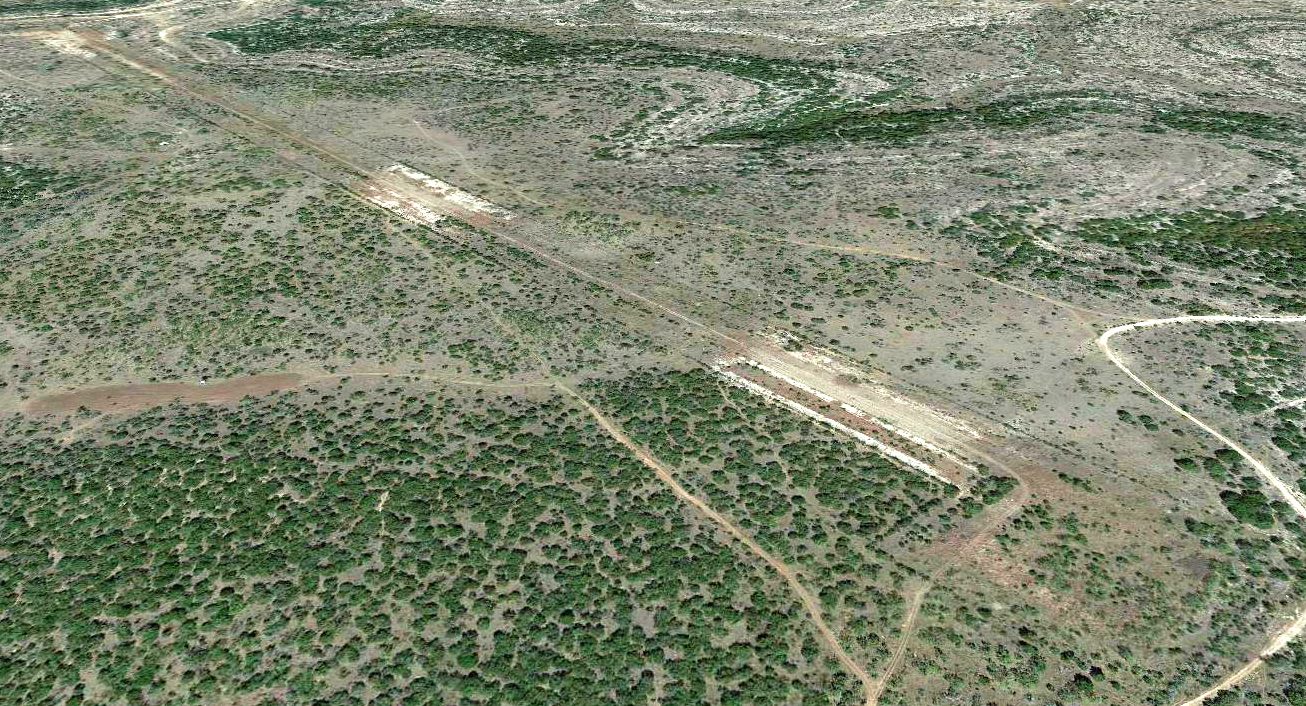
As seen in a 1996 USGS aerial view looking north, the Vancourt airfield consisted of 3 paved runways (each 5,000' long) & a number of taxiways.
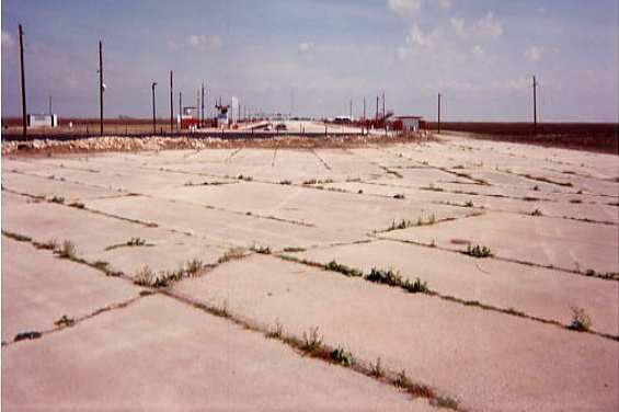
Vancourt has been reused as a drag racing strip following its closure by the Air Force,
with the western N/S runway being used as a parking area, and the NE/SW runway serving as a drag strip.
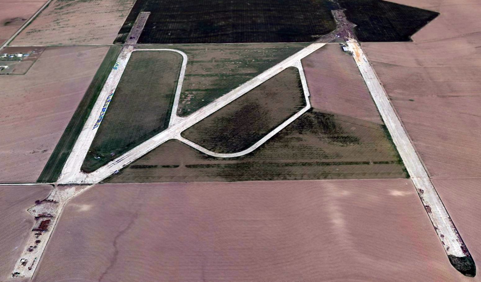
A 2015 aerial view looking north at the remains of the Vancourt airfield showed the runways to remain largely intact.
____________________________________________________
34.08, -99.29 (Northwest of Wichita Falls, TX)
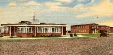
A 1942 postcard of Vernon TX presumably depicted buildings of Victory Field (courtesy of Steve Cruse).
Victory Field was not yet depicted on the September 1940 Dallas Sectional Chart.
Victory Field was established in 1941 as a contract flying school for primary training
for the Army Air Forces during WW2 by Hunter Flying Service & Richey Flying Service.
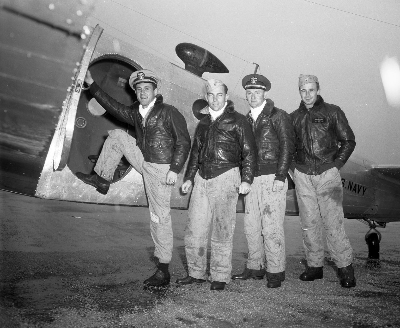
At its peak,Victory Field had 122 instructors, 175 aircraft, and 400 cadets for each class.
A WW2 -era aerial view looking southwest at Victory Field, showing 20 single-engine aircraft, along with 2 hangars & other buildings.
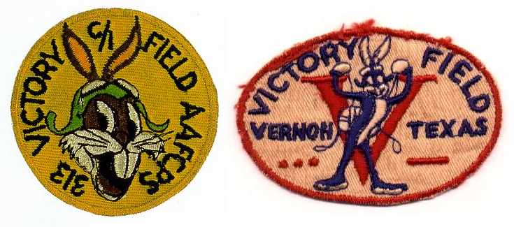
Two undated WW2-era unit patches from Victory Field (courtesy of David Brooks).
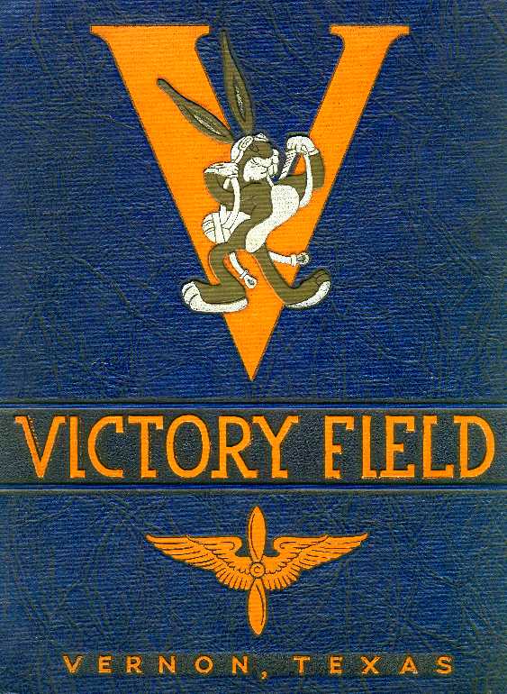
An undated WW2-era class book cover from Victory Field.
Norman Delker was a flight instructor in the cadet training program from 1942-44.
In his words, "It was a great group of men that did the instructing.
Paul brown was the director of flying at the time. Dan Hunter was the owner of the operation.
We had approximately 200 Fairchild PT-19s in which the cadets were given their first 65 hours in the air.
After that they went on to BT-13s and then AT-6s when they got their wings upon graduation.
It was a wonderful experience."
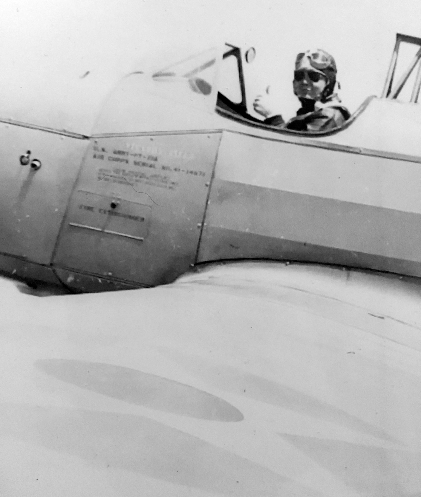
A 1943 photo of Earl Parker giving the thumbs-up from his PT-19 at Victory Field (courtesy of his grandson, Matt Beckum).
The earliest aeronautical chart depiction which has been located of Victory Field was on the February 1943 Dallas Sectional Chart.
It depicted Victory as a civilian commercial/municipal airport.
Victory Field was deactivated in 1944 because of the glut of AAF pilots.
The September 1945 Dallas Sectional Chart depicted Victory as an auxiliary airfield.
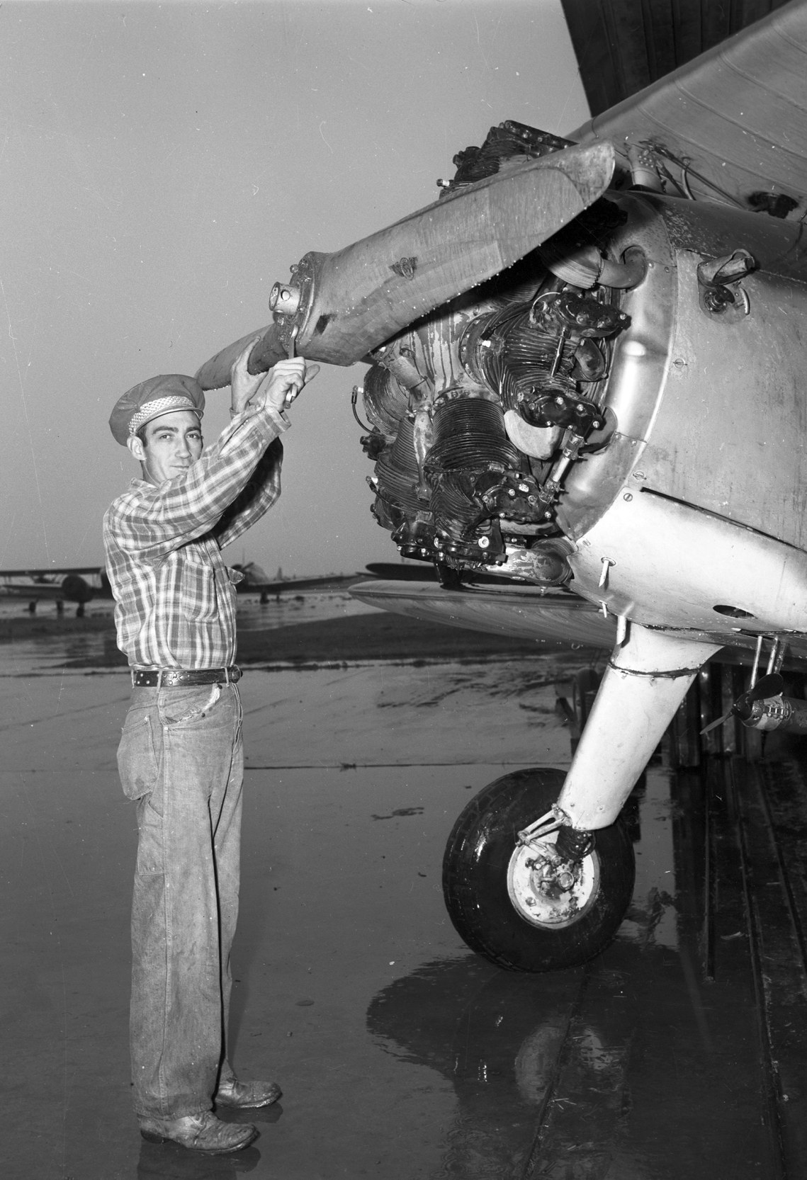
Oroginally captioned: “Hines adjusts a prop on a reconditioned plane for sale at Vernon's Victory Field. He is hired by a private contractor.
Used planes cheaper than used cars at Vernon's Victory Field sales lot range from $590-$8,500.
It's one of those post-war paradoxes, but you can buy a used plane cheaper than you can a used automobile, if you have any use for a plane!
C.C. Grady, the Reconstruction Finance Corporation's used plane salesman at Victory Field,
has more than 800 planes for the buyer to choose from & they range in size from a 2-seat open cockpit biplane trainer to a dive-bomber or a twin-engine 5-place Cessna cabin job.
"We've sold about 100 in the last 3 weeks & the buyers are still coming, rain or shine," Grady laughed.
Victory Field was was depicted as a commercial airfield on the 1949 Oklahoma City Sectional Chart (according to Chris Kennedy).
The last aeronautical chart depiction which has been located of Victory Field was on the February 1950 Dallas Sectional Chart.
It depicted Victory as a civilian airport having a 2,700' paved runway.
In 1950 Victory Field's buildings were taken over by the TX Department of Mental Health & Mental Retardation,
which established the Vernon Center as a unit of Wichita Falls State Hospital.
Victory Field was no longer depicted at all (not even as an abandoned airfield) on the August 1952 Dallas Sectional Chart.
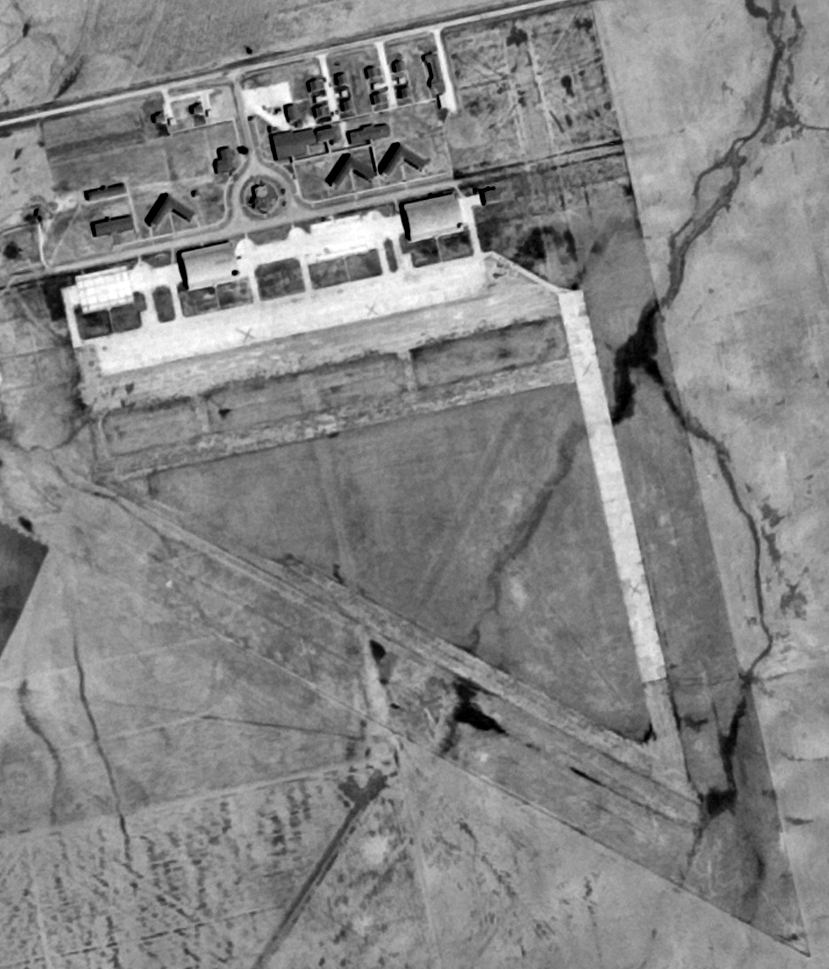
A 9/6/53 USGS aerial view showed Victory Field after the airfield had been closed but was still completely intact.
Tamara Griffith recalled that "one of the hangars from Victory Field was moved
and is still in use at Wilbarger County Airport [in Vernon].
I learned to open those doors, and wandered through much of the unused areas as a kid
while my dad was usually out crop dusting in Stearmans."
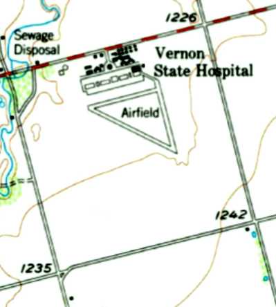
The 1958 USGS topo map depicted 3 paved runways, labeled simply as “Airfield”,
with the former Victory Field buildings labeled as Vernon State Hospital.
Only 1 of the former hangars was still depicted.

In the 1994 USGS aerial photo, the airfield remains consisted of a single concrete runway (approximately 1,500' long),
along with traces of the other 2 runways.
The last of the 2 hangars had evidently been removed at some point between 1958-94.
In 1995, the property became the Victory Field Correctional Academy, a military-style youth correctional facility.
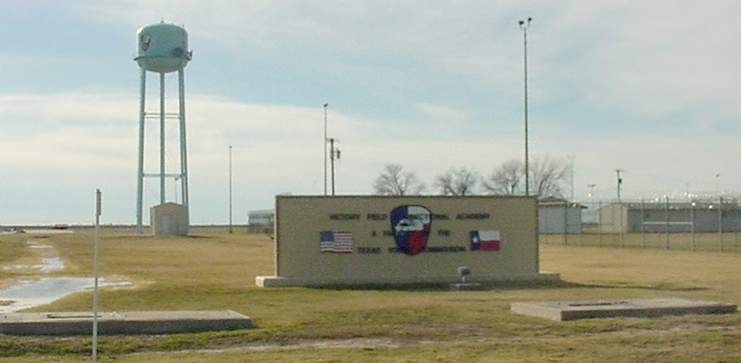
A 2001 photo by Scott Murdock of the entrance sign at the Victory Field Correctional Academy.
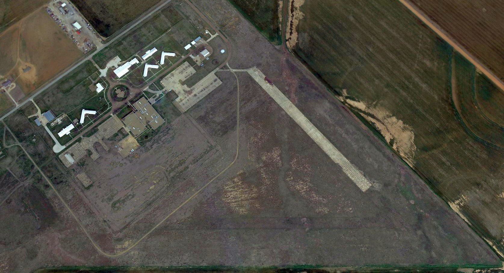
A 2015 aerial view looking northeast at the site of Victory Field, showing the runway & ramp remains south of the prison buildings.
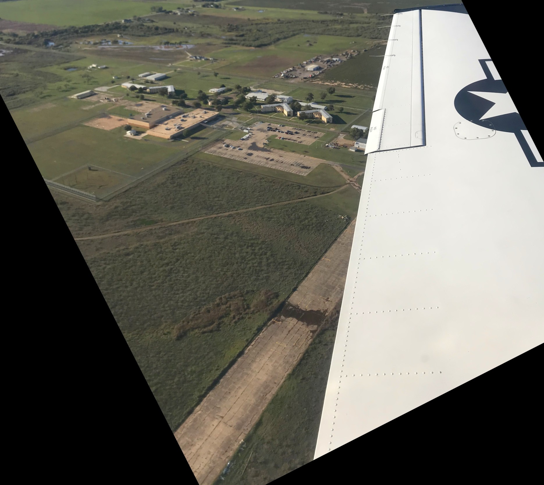
A 10/26/18 aerial view by Matt Beckum from his USAF T-6 Texan 2 looking northwest at the site of Victory Field, where his grandfather, Earl Parker, served in 1943.
The remains of the concrete northeast/southwest runway & the ramp are still visible, and several military buildings remain in use.
See also:
http://www.airforcebase.net/trips/call/call.html
____________________________________________________
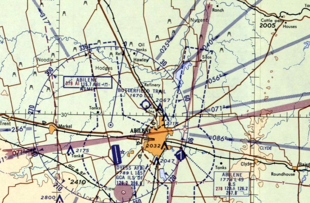
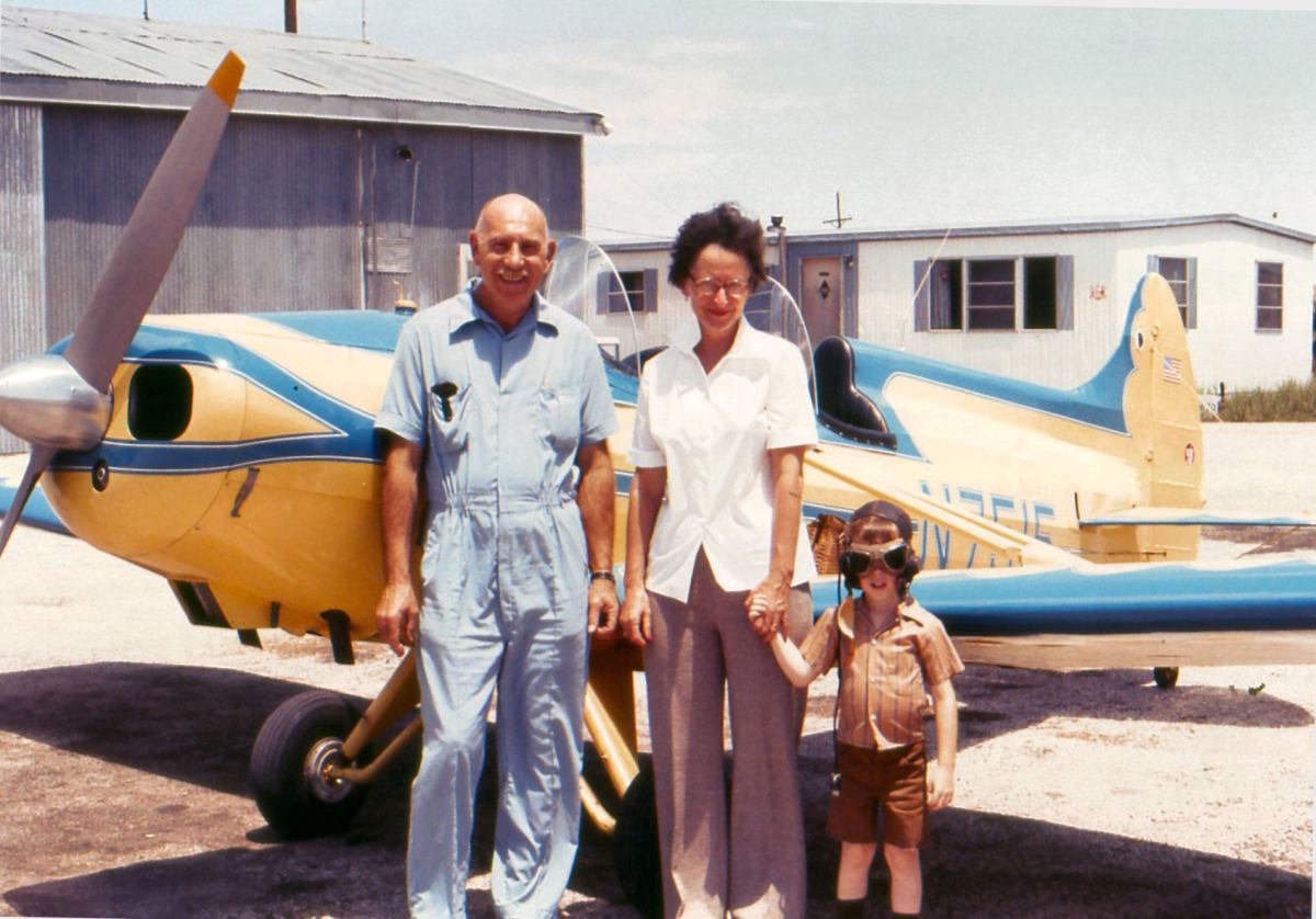
Butterfield Trail Airport, North Abilene, TX
32.54, -99.77 (West of Fort Worth, TX)
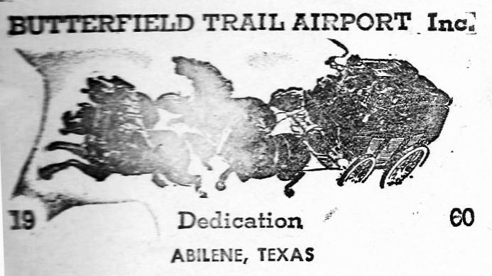
A 1960 postmark commemorating the dedication of Butterfield Trail Airport.
No airport was yet depicted at this location on a 11/11/54 USGS aerial photo,
or on the August 1960 Dallas Sectional Chart.
This general aviation airport was dedicated in 1960, according to a commemorative postmark.
The earliest depiction which has been located of Butterfield Trail Airport
was on the March 1961 Austin Sectional Chart (courtesy of Chris Kennedy).
It depicted Butterfield Trail Airport as having a 3,100' unpaved runway.
George Spurr recalled, “I have many fond memories of Butterfield Trail Airport.
The airport, the people I met there, the airplanes we flew and hangared there - killing rattlesnakes - the list goes on.
I made my solo flight there in 1962 & got my Private License later the same year in a Cessna 150 (N1152Y).
I was in the Air Force then & Paul Volgamore was the Fixed Base Operator at the time & the ram-rod behind the Dyess AFB Aero Club.
I worked there helping out, doing odd jobs & building flight time there from 1964-68 when I had some time off.
The Butterfield Overland Stage company... That is where the airport got it name since the stage ran over that spot of ground on it's way to California.
When I was at Butterfield you could still see the ruts made by the coaches traveling to & from back in their day.
Some people (non-flyers) came to the airport just to see the tracks in the land which ran along with the dirt runway.”
The 1963 TX Airport Directory (courtesy of Steve Cruse)
described Butterfield Trail Airport as having a 3,100' paved runway.
It listed the operator as Air Service Inc., and listed the manager as Paul Volgamore.
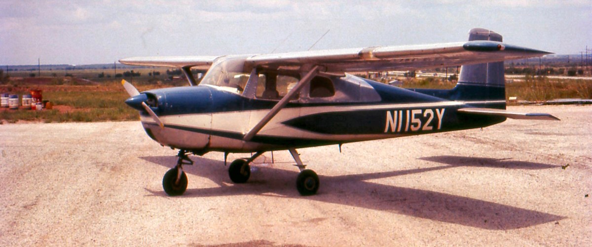
A 1966 photo by George Spurr of the Cessna 162 in which he flew his first solo at Butterfield Trail Airport.
George observed the photo was “Taken at the North end of the T-Hangar row looking North.”
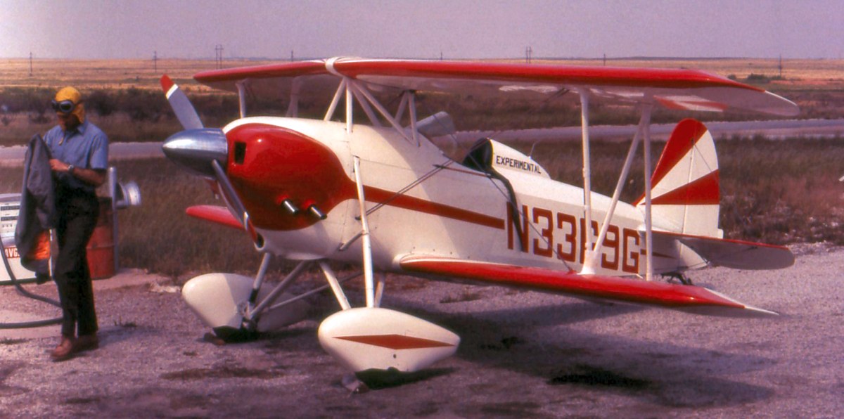
A circa 1966-73 photo by George Spurr at Butterfield Trail Airport of “a customer at the fuel pump - a frequent visitor, and a one-off I think called the Clark Dollar.
Taken in front of the hangers looking West. You can see the runway in the background.”
A circa 1966-73 photo by George Spurr at Butterfield Trail Airport of “my frequent customers with my little son.
Taken at the South end of the hangars looking South East. The large double-wide mobile home was used as an office, pilot lounge, and training room.
The corner of the hangar behind them has a small office / line shack in the corner & contains the only paved hangar(s) on-site.
It was a double hangar big enough for at least 2 airplanes.
It served mostly as a shop while Paul was there & later for Abilene Aero before they moved to the big airport & put into motion the death of Butterfield.”
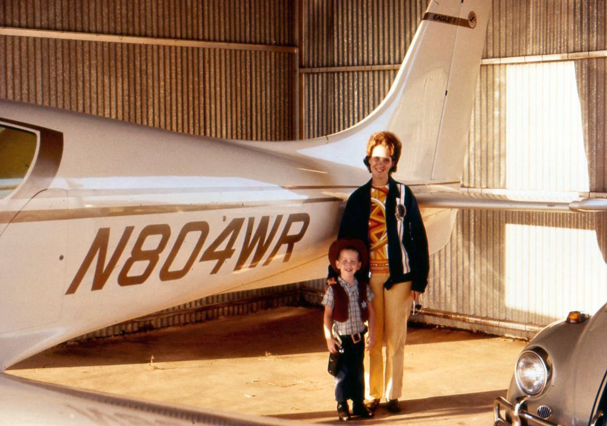
A circa 1966-73 photo by George Spurr at Butterfield Trail Airport, “Inside the 'big' hangar with the Windecker Eagle prototype (my wife & son).
The son of the designer married a woman from Abilene so they were frequently at Butterfield.”
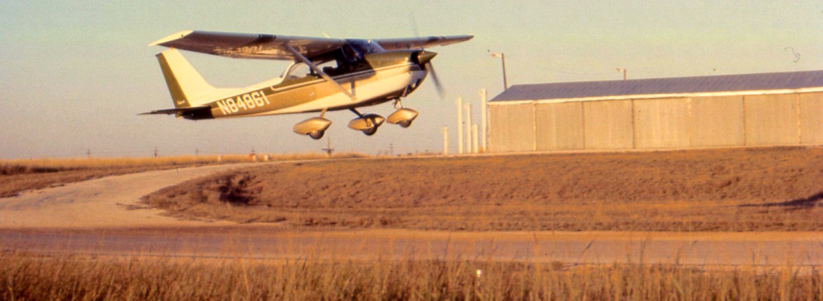
A circa 1966-73 photo by George Spurr at Butterfield Trail Airport, “Looking northeast: One of my rental 172's taking off from the asphalt runway for a local pleasure flight.
You can see the runway, the hill behind & one of the taxiways up, the North end of the West hangar row
and way in the background right at the end of the hangars you can see the stacks of the Pride Refinery across the highway from Butterfield.
They made some gasoline but their main purpose was refining JP-4 jet fuel for Dyess AFB & sending it over to the storage tanks at Dyess via an underground pipeline.”
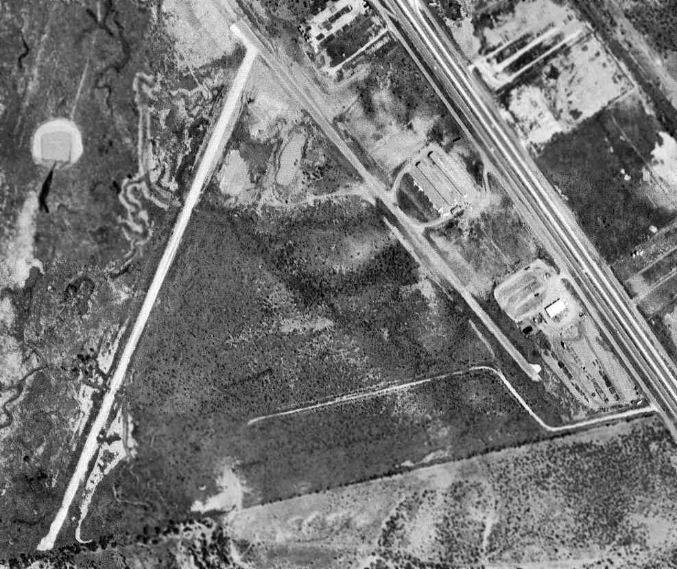
A 9/29/67 USGS aerial photo depicted Butterfield Trail Airport as having a one paved runway & one unpaved runway.
Three single-engine planes were visible around 2 hangars on the northeast side.
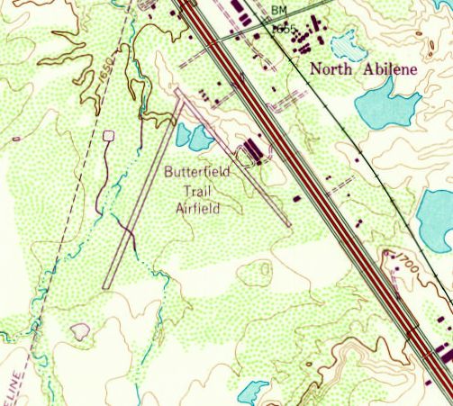
The 1967 USGS topo map depicted “Butterfield Trail Airfield”
as having 2 runways & several buildings on the east side.
The fixed-base operator Abilene Aero began in 1968 at Butterfield Trail Airport as a partnership with 4 employees.
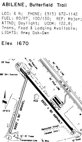
The 1970 TX Airport Directory (courtesy of Ray Brindle) depicted Butterfield Trail
as having a 2,500' asphalt Runway 13/31 & a 3,000' gravel Runway 1/19.
Two hangars were depicted on the northeast side of Runway 13/31.
George Spurr recalled, “I came back to Butterfield as the 'live-in' manager under Abilene Aero in 1970 (til about 1973).
I bought a mobile home for my family & we lived on-site.
Fixed-base operator Abilene Aero moved from Butterfield Trail Airport to Abilene Municipal Airport in 1971.
Linda Medellin reported that “Paul Volgamore often spoke fondly of operating the airport.
He did so after he retired from the Air Force as a Major.”
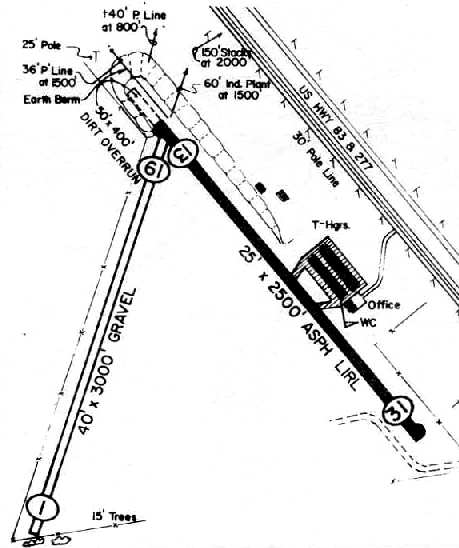
Butterfield Trail Airport depicted in the 1978 TX Airport Directory (courtesy of Chris Kennedy)
as having a 2,500' asphalt Runway 13/31 & a 3,000' gravel Runway 1/19.
Two rows of T-hangars & an office were located along the east side of Runway 13/31.
The managers were listed as O. Higgins & K. Waddell.
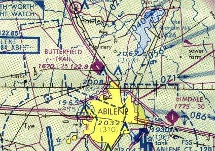
The last aeronautical chart depiction which has been located of Butterfield Trail Airport was on the 1978 Dallas Sectional Chart.
It depicted Butterfield Trailer as having a 2,500' paved runway.
Daniel Reese reported, “Kent Waddel was co-founder or owner of Abilene Aero.”
According to Randall Reese, in the mid 1970s or early 1980s the property was bought by Westex Drilling Company
and eventually used for storage of oilfield equipment.
Butterfield Trail Airport was evidently closed at some point between 1978-82,
as it was no longer listed among active airfields in the 1982 AOPA Airport Directory.
Butterfield Trail Airport was still depicted on the 1987 USGS topo map, even though it was apparently closed by that point.
The January 1987 Dallas Sectional Chart (courtesy of Stu Sibitzky) depicted Butterfield Trail Airport as an abandoned airfield.
A 1995 USGS aerial view looking north showed the 2 runways of the former Butterfield Trail Airport were still quite discernible, although somewhat deteriorated.
Several of the former hangars appeared to still be standing.
A circa 2006 aerial photo looking north at the 2 former hangars which remain standing at the site of Butterfield Trail Airport.
A 2014 aerial view looking north showed the site of Butterfield Trail Airport remained recognizable as a former airfield.
The site of Butterfield Trail Airport is located west of the intersection of Route 83 & Market Road.
____________________________________________________
D-Bar Ranch Airfield, Sanco, TX
32.04, -100.46 (Southwest of Fort Worth, TX)
D-Bar Ranch Airfield was depicted simply as “Landing Strip” on the 1987 USGS topo map.
Photo of the airfield while open has not been located.
George Horn recalled, “I personally supervised the construction of the airfield.
I personally designed & directed it's construction for the owner, circa 1983-86.
The field is a 5,280' runway built on the 'D-Bar Ranch',
owned at the time by S. E. 'Skinny' Adams & his wife Elsie & their trust.
Skinny was also the owner of Adams Abstract Company in Robt Lee TX.
He was a walking, talking history-book of Coke County & environs,
and I worked for the family as their chief pilot (under another business they owned, Lamar Savings, of Austin).
Elsie was a retired schoolteacher. Two truly adorable people.
My direct boss was Skinny's son, Stanley Adams, who was CEO of the bank.”
George continued, “The family wanted a runway constructed on top of that mesa
and I designed & supervised its construction.
It consisted of a caliche underlayment & covered with a 2-course oil-penetration mix asphaltic topcoat.
It's center crossed over a dry creek & so triple-corrugated drainage culverts were laid down & the runway was overlaid that arroyo
(you can still see that area as the lighter-colored area alongside the middle portion of the runway).
It was surrounded by a 8' game-proof fence which required 2 drilling rigs to drill 4' deep holes 10' apart
for 12' long creosoted poles for fence posts.
The fencing was a significant expenditure of the project.”
George continued, “It has 300' x 300' turnarounds/parking at each end, and was never lighted.
It was painted with reflective center stripes in 1986.
It was completed over a 3-year period, and the company jet (Hawker), King Airs, and my personal airplane
used it only a few times, and then it was relegated to an unused status (remember the S&L failures of 1986?).
It was never registered as a runway with the FAA & the official position with anyone who asked was that it was merely a 'paving experiment',
not to be used without permission.”
The D-Bar Ranch Airfield was depicted as "Landing Strip" on the 1987 USGS topo map.
George Horn recalled, “I left the employ of the Adams family in the late 1980s
and by the late 1990s the runway condition was deplorable & unsafe even for automobiles
as it has small trees & brush which has grown up penetrating the runway.
I advise anyone overflying it to avoid it not only for their own safety
but also to avoid possible legal actions from the property owners who never allowed outside use of it.”
The earliest photo which has been located of the D-Bar Ranch Airfield was a 1/28/96 USGS aerial view looking northwest.
It depicted the airfield as consisting of a single paved 5,280' runway, with a paved ramp area at each end of the runway.
There did not appear to be any signs of any buildings, or any indication that the field had been used recently.
The D-Bar Ranch Airfield was no longer depicted at all (even as an abandoned airfield) on 2002 aeronautical charts.
A 2017 aerial view looking northwest at the remains of the D-Bar Ranch runway.
A 2024 property sale listing for the D-Bar Ranch said, “There is an old asphalt runway over a mile in length that is high-fenced & could be resurfaced & restored to functionality.”
____________________________________________________
Or if you prefer to contact me directly concerning a contribution (for a mailing address to send a check),
please contact me at: paulandterryfreeman@gmail.com
If you enjoy this web site, please support it with a financial contribution.
____________________________________________________
This site covers airfields in all 50 states.