Abandoned & Little-Known Airfields:
Texas: Eastern Dallas area
© 2002, © 2025 by Paul Freeman. Revised 10/24/25.
This site covers airfields in all 50 states: Click here for the site's main menu.
____________________________________________________
Please consider a financial contribution to support the continued growth & operation of this site.
Cole Airport (revised 9/24/24) - Dallas Hudson Airport / Dallas-Garland Airport (revised 11/18/19) - Mustang Airport (revised 10/24/25)
Luscombe / Temco-Garland Airport (revised 11/18/19) - Marshall Airport (revised 4/14/18) - Rives Airpark (revised 12/30/23) - White Rock Airport (revised 9/11/22)
____________________________________________________
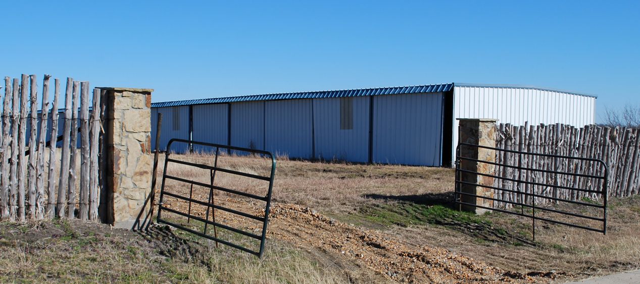
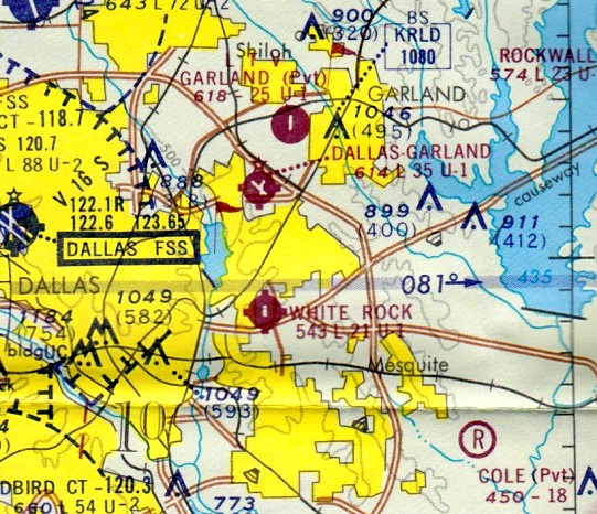
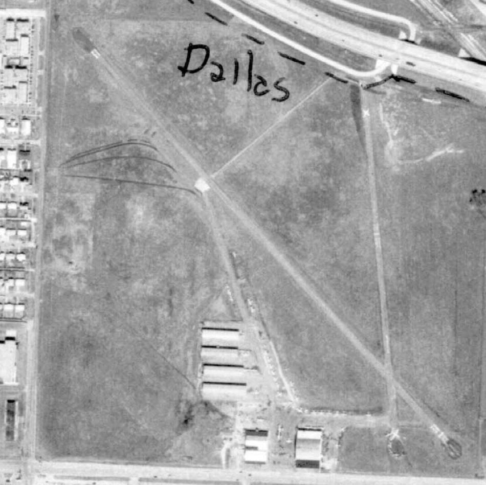
Rives Airpark (T33), Royse City, TX
32.855, -96.311 (East of Dallas, TX)
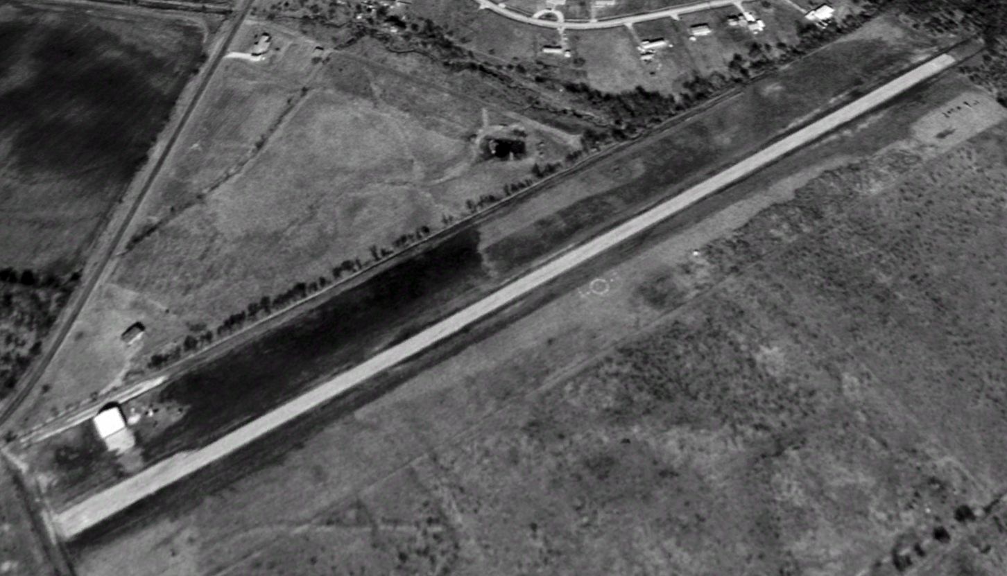
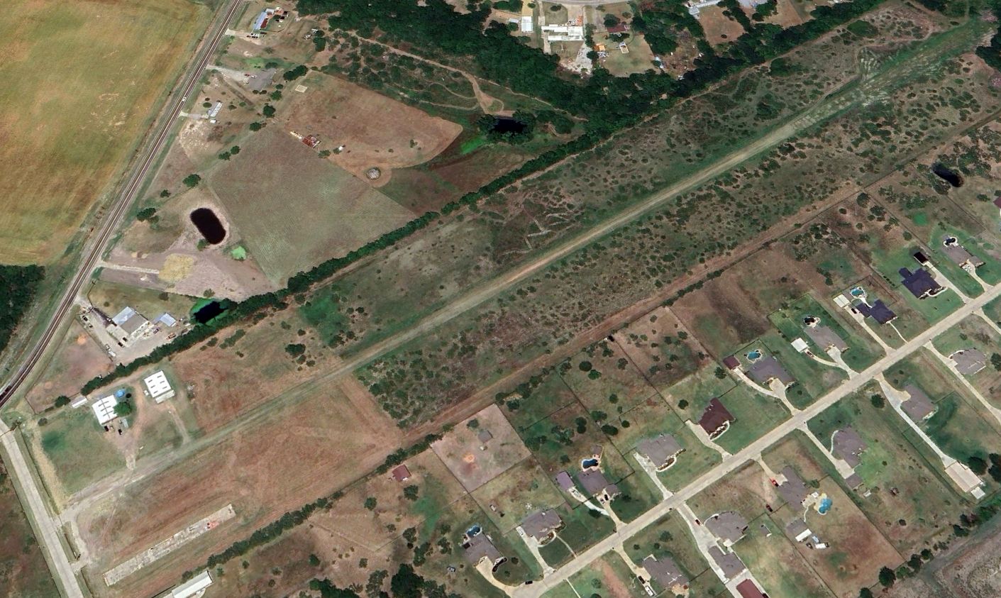
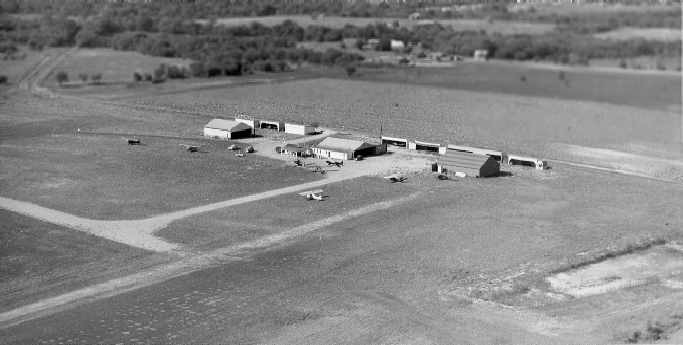
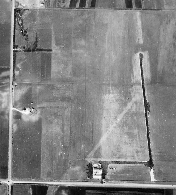
Rives Airpark, as depicted on a 1996 aerial view looking north.
Photo of the airfield while in use has not been located.
This small general aviation airport was evidently constructed at some point between 1981-95,
as it was not yet depicted on a 1981 aerial photo, the 1986 or 1991 USGS topo maps, or the 1993 DFW Terminal Chart (courtesy of Jonathan Westerling).
The earliest depiction which has been located of Rives Airpark was on a 1995 aerial photo.
It showed a single northeast/southwest runway, which appeared to be newly-constructed, with 1 hangar on the west side.
The earliest photo which has been located of Rives Airpark was a 1996 aerial view looking north.
It showed a single northeast/southwest runway, with 1 hangar on the west side.
The earliest aeronautical chart depiction which has been located of Rives Airpark was on the 2004 DFW Terminal Chart (courtesy of Jonathan Westerling).
It depicted Rives as a public-use airport having a single 2,800' paved northeast/southwest runway.
A 2005 aerial view showed 2 more hangars had been added to Rives Airpark at some point between 1996-2005.
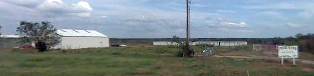
A 2007 photo looking east showed the 3 hangars on the west side of Rives Airpark.

The last aeronautical chart depiction which has been located of Rives Airpark was on the 2009 Dallas Terminal Chart.
It depicted Rives as a public-use airport having a single 2,800' paved northeast/southwest runway.
A 2013 inspection by the State of TX (courtesy of Randy Coller) described Rives Airpark as having “Runway 4/22 overgrown with 2-3' weeds & grass; potholes.”
Randy Coller recalled, “There was a new owner in 2016, [they] wanted to go from private-us to public-use. I inspected it.
I wouldn't drive my truck down the runway. It was difficult to walk the runway. After my inspection, I think he decided it was too much to make it usable.”
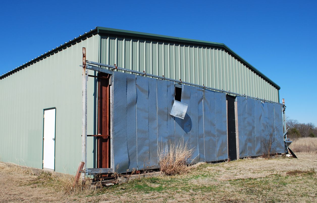
A 2016 photo by Randy Coller of a Rives Airpark hangar.
A 2016 photo by Randy Coller of a Rives Airpark hangar.
A 2016 photo by Randy Coller of a Rives Airpark hangar.
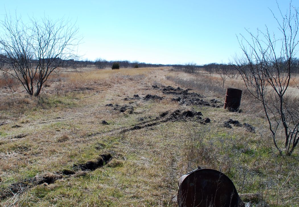
A 2016 photo by Randy Coller of the Rives Airpark runway.
The 2016 Inspection report (courtesy of Randy Coller) described Rives Airpark as follows:
“Airport unsuitable for aircraft. 55 gallon barrels on runway. Tire ruts in runway greater than 12” deep.”
Rives Airpark was no longer depicted on the 2016 Dallas Sectional Chart.
A 2018 aerial photo showed the hangar on the south side of Rives Airpark was removed at some point between 2016-2018.
A 2023 photo looking east depicted Rives Airpark hangars, along with single-family houses which had been built adjacent to the east side.
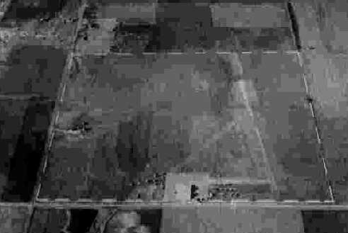
A 2023 aerial view looking north showed 2 Rives Airpark hangars, the foundation of a 3rd hangar, and the deteriorated runway.
Thanks to Randy Coller for pointing out this airfield.
___________________________________________________
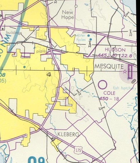
32.739, -96.56 (Southeast of Downtown Dallas, TX)
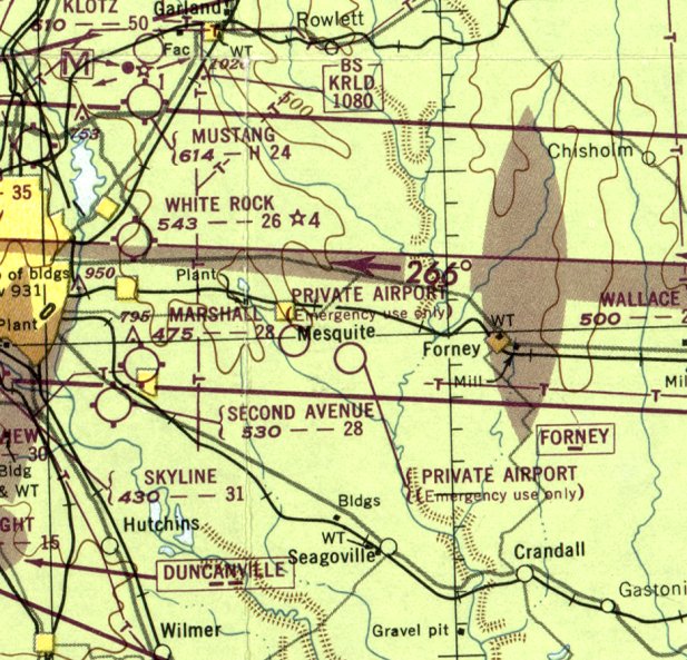
Cole Airport, as depicted on the September 1948 Dallas Sectional Chart, which labeled it generically as “Private Airport”.
This small general aviation airport was located to the east of Dallas.
Cole Airport was apparently built at some point in 1948,
as it was not yet depicted on the January 1948 Dallas Local Aeronautical Chart.
The earliest depiction which has been located of Cole Airport was on the September 1948 Dallas Sectional Chart,
which labeled it generically as “Private Airport (Emergency use only)”.
The earliest photo which has been located of Cole Airport was a 1956 aerial view.
It depicted Cole as having 2 unpaved runways, with a few small buildings on the southeast side.
The 1959 USGS topo map depicted “Cole Airport (Private)” as having 2 unpaved runways, with a few small buildings on the southeast side.
The 1966 Dallas Local Aeronautical Chart depicted Cole Airport as having a 1,900' unpaved runway.

The only photo which is available of Cole Airport was a 9/18/68 USGS aerial view.
It showed that Cole Airport had lost its crosswind runway, with only the northwest/southeast runway remaining.
Mel Asberry recalled, “Cole Airport In December of 1969, I stopped at the house to get permission to land my 1941 Taylorcraft there to disassemble it, take it home, and re-cover it.
The response was a very pleasant, 'No problem!'
I landed there in addition to a friend who flew in to help me. While we were taking the wings off, a gentleman drove by & stopped.
He asked why I had not gotten permission to land at a 'Private Airport'. I answered that I had.
He then told me that HE owned the airport & that I had not gotten permission from him.
Apparently the guy I spoke to was leasing the property from him & did not have authority to give permission.
Anyway, he said that everything was good & good luck with my refurbishment.”
A 1972 aerial view showed Cole Airport in an unchanged fashion.
The last aeronautical chart depiction which has been located of Cole Airport was on the July 1978 Dallas Terminal Chart.
It depicted Cole as having an 1,800' unpaved runway.
Cole Airport was evidently closed (for reasons unknown) at some point between 1978-79,
as a 1979 aerial view no longer showed any trace of the runway, with the area having been wiped clean,
but the small buildings remained at the southeast corner.
Cole Airport was no longer depicted on the July 1985 Dallas Sectional Chart.
A 1989 aerial photo showed houses covering the site of Cole Airport, with no trace remaining of the little airport.
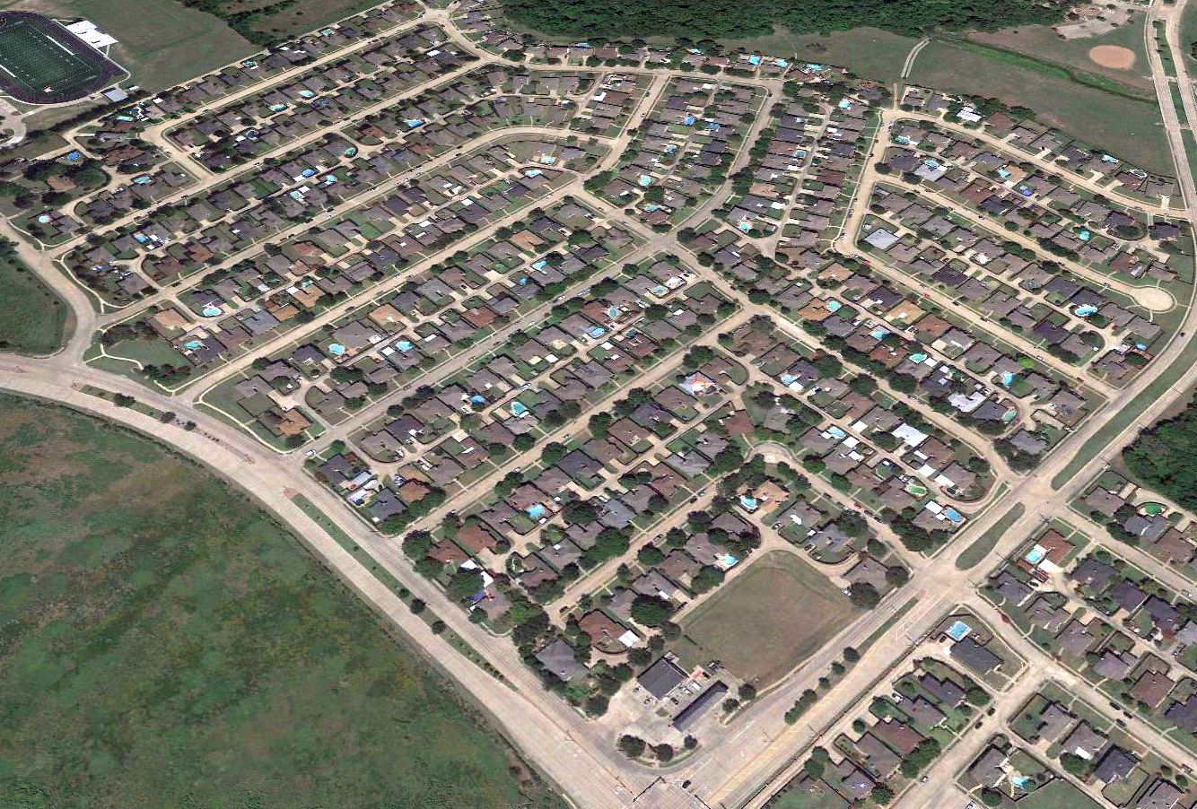
A 2017 aerial view looking north showed no trace remaining of Cole Airport.
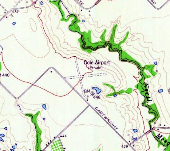
The site of Cole Airport is located north of the intersection of East Cartright Road & Faithon P Lucas Senior Boulevard.
Thanks to Paul Clark for pointing out this airfield.
___________________________________________________
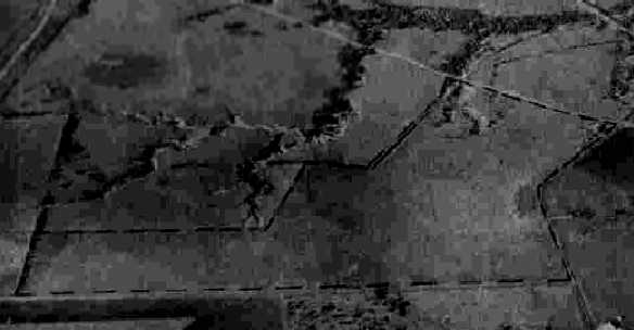
Marshall Airport, Pleasant Grove, TX
32.74, -96.69 (Southeast of Downtown Dallas, TX)
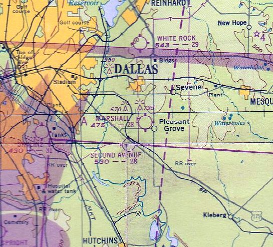
Marshall Airport, as depicted on the January 1948 Dallas Local Aeronautical Chart.
Photo of the airfield has not been located.
This short-lived small airport was located to the southeast of Dallas.
Marshall Airport was apparently built at some point between 1946-48,
as it was not yet depicted on the March 1946 Dallas Sectional Chart.
The earliest depiction which has been located of Marshall Airport was on the January 1948 Dallas Local Aeronautical Chart,
which depicted Marshall as having a 2,800' unpaved runway.
Paul Clark recalled, “In the 1940s & early 1950s there was an airport in Pleasant Grove east of Dallas.
It was of a military nature; I remember my dad taking me into a large Quonset Hut hangar/office & letting me sit in a Link Trainer.
The hangar was on Buckner Boulvevard.”
The last aeronautical chart depiction which has been located of Marshall Airport was on the February 1950 Dallas Sectional Chart.
It depicted Marshall as having a 2,800' unpaved runway.
Marshall Airport was evidently closed at some point between 1950-52,
as it was no longer depicted on the August 1952 Dallas Sectional Chart.
Its closure was presumably caused by the growth of the surrounding suburban development -
yet another American grassroots airport swallowed up by development.
A 1952 aerial photo showed no obvious trace of Marshall Airport, with suburban development extending outward from Dallas.
A 2017 aerial photo showed the site of Marshall Airport to be heavily redeveloped.
Paul Clark observed, “The big square building [on the right side] of the photograph is approximately where the hangar was, with Buckner Boulevard running north & south on the right.”
Thanks to Paul Clark for pointing out this airfield.
___________________________________________________
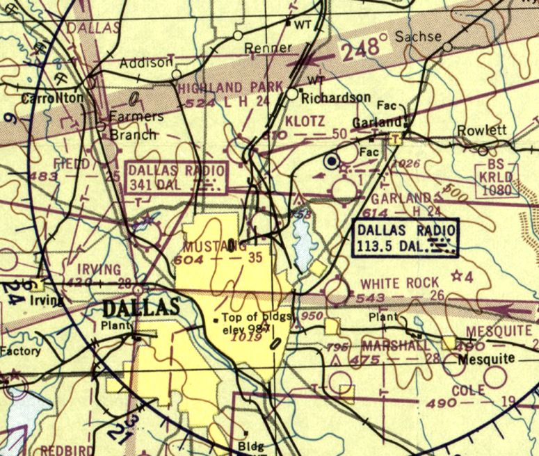
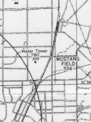
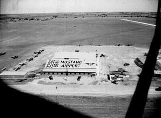
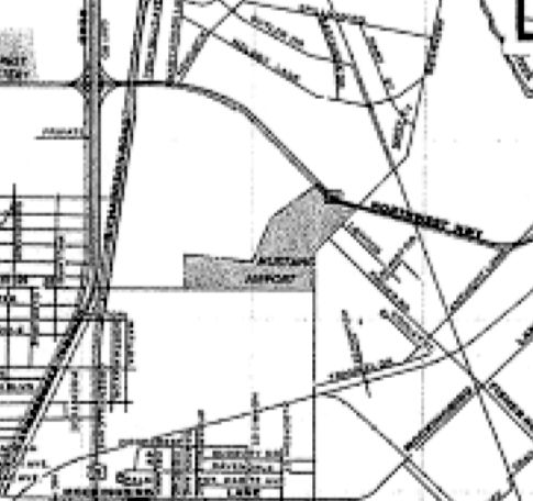
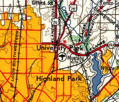
Mustang Airport, Highland Park, TX
32.86, -96.76 (Northeast of Downtown Dallas, TX)
Mustang Field, as depicted on the August 1941 Dallas Sectional Chart.
Mustang Field was named after the Southern Methodist University Mustangs, as the school was located nearby.
It is not known if the airport had any connection to the school.
Mustang Field was apparently built at some point between 1940-41,
as it was not yet listed among active airfields in the Airport Directory Company's 1937 Airport Directory (courtesy of Bob Rambo),
nor depicted on the September 1940 Dallas Sectional Chart.
The earliest depiction of Mustang Field which has been located was on the August 1941 Dallas Sectional Chart,
which depicted Mustang Field as a commercial/municipal airport.
The earliest photo which has been located of Mustang Airport
was a 10/15/43 aerial view looking northeast from the 1945 AAF Airfield Directory (courtesy of Scott Murdock).
It depicted Mustang Airport as an open grass area.
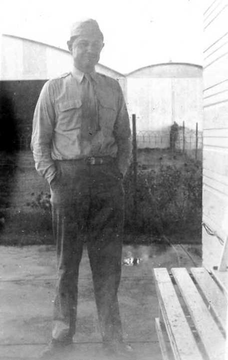
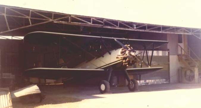
A circa 1943 photo (courtesy of Elwood Christ) of Warren Christ in front of a Mustang Airport hangar.
Elwood Christ recalled, “My father, Warren Christ, was a flight instructor working for the Civilian Pilots Training Program during WWII.
My mother always told me that his first job as a flight instructor was in 1943 for the Army at 'Mustang Aviation' at Dallas.
I assume that 'Mustang Aviation' was at Mustang Airport.”
The April 1944 US Army/Navy Directory of Airfields (courtesy of Ken Mercer)
described Mustang Airport as having a 3,900' unpaved runway.
Mustang Airport was depicted on the August 1944 Dallas Sectional Chart (courtesy of David Brooks).
A WW2 era approach plate for Love Field (courtesy of Terry Smith) depicted Mustang Field as an irregularly-shaped property outline.
The 1945 AAF Airfield Directory (courtesy of Scott Murdock) described Mustang Airport
as a 160 acre irregularly-shaped property having 4 sod runways,
the longest being a 3,150' east/west/ strip.
The field was said to have a total of 13 hangars, the largest being a 98' x 65' metal structure.
Mustang Airport was said to be owned & operated by private interests.
An aerial view of Mustang Airport from an article entitled "Private Airports"
in the May 1947 issue of the Dallas Chamber of Commerce Magazine (courtesy of Jeff Ferguson).
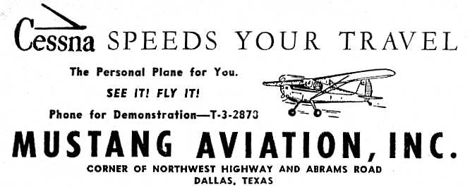
An advertisement for Mustang Aviation from the May 1947 issue of the Dallas Chamber of Commerce Magazine (courtesy of Jeff Ferguson).
Mustang Airport was described in an article entitled "Private Airports"
in the May 1947 issue of the Dallas Chamber of Commerce Magazine (courtesy of Jeff Ferguson):
"Located at Northwest Highway & Abrams Road,
Mustang Airport provides private flyers with an all-sod landing area of 160 acres.
Under the management of N.T. Womack, T.O. Womack, and N.T. Womack Jr.,
the field offers a continuous program of flight & ground training.
Seventy-eight students are currently enrolled, most of whom are studying under the G.I. training bill.
Approximately 75 planes, rental & privately owned, operate from Mustang Airport.
Mustang Aviation Inc. is distributor for Cessna aircraft & provides repair & service facilities."
John Little recalled, “In the 1940s our Dad had an airplane at Mustang Field.”
The January 1948 Dallas Local Aeronautical Chart depicted Mustang Field as having a 3,200' unpaved runway.
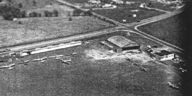
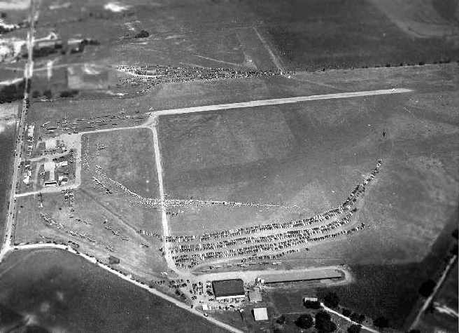
A 1948 aerial view depicted a total of 17 light aircraft parked near a large number of T-hangars at Mustang Field.
A 1948 aerial view by Tom Collins (from the Dallas Historical Society) of Mustang Field showed the hangar along Northwest Highway.
The "3252" painted on the roof of the hangar presumably refers to the runway length.

The last aeronautical chart depiction which has been located of Mustang Airport was on the February 1950 Dallas Sectional Chart.
It depicted Mustang Field as having a 3,500' unpaved runway.
Mustang Airport was depicted on a 1951 Dallas street map (courtesy of Michael McMurtrey) as an irregularly-shaped property outline.

The last photo which has been located of Mustang Field was a 1952 USGS aerial view.
The row of T-hangars on the northeast side had been removed at some point between 1948-52,
and the number of aircraft on the field had decreased to 10.
According to Jerry Felts, "I know [Mustang Airport] was still open as of about 1954."
Mustang Field evidently closed (for reasons unknown) at some point between 1954-55,
as it was no longer depicted on the February 1955 Dallas Sectional Chart.
A 1956 aerial photo depicted a new road cutting through the Mustang Field site,
and there was no recognizable remains of an airport, with the hangar having been removed.
The last depiction which has been located of Mustang Airport was on the 1958 USGS topo map,
even though the airport had evidently been closed already for at least 2 years by that point.
Mustang Field was not depicted at all on the 1960 Humble Oil DFW road map,
nor listed among active airfields in the 1963 TX Airport Directory.
A 1993 aerial photo showed no recognizable trace of Mustang Airport.
Steve Harkins recalled, “I worked at the Park Central office complex in Dallas, formerly the location of Mustang Airport.
As late as the late 1990s there were still small concrete pads in the grassy areas near the east parking lots,
which apparently had had landing or taxiway lights bolted to them.”

A 2023 aerial photo showed the site of Mustang Airport to be heavily redeveloped.
The site of Mustang Airport is located northwest of the intersection of Lovers Lane & Abrams Road.
___________________________________________________
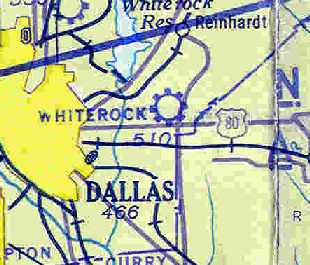
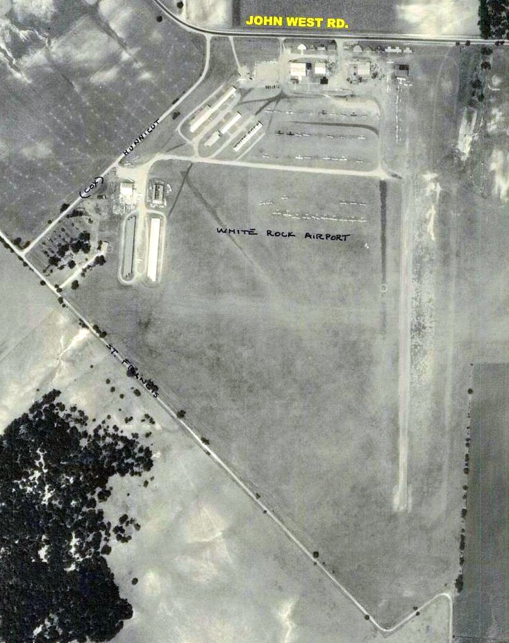
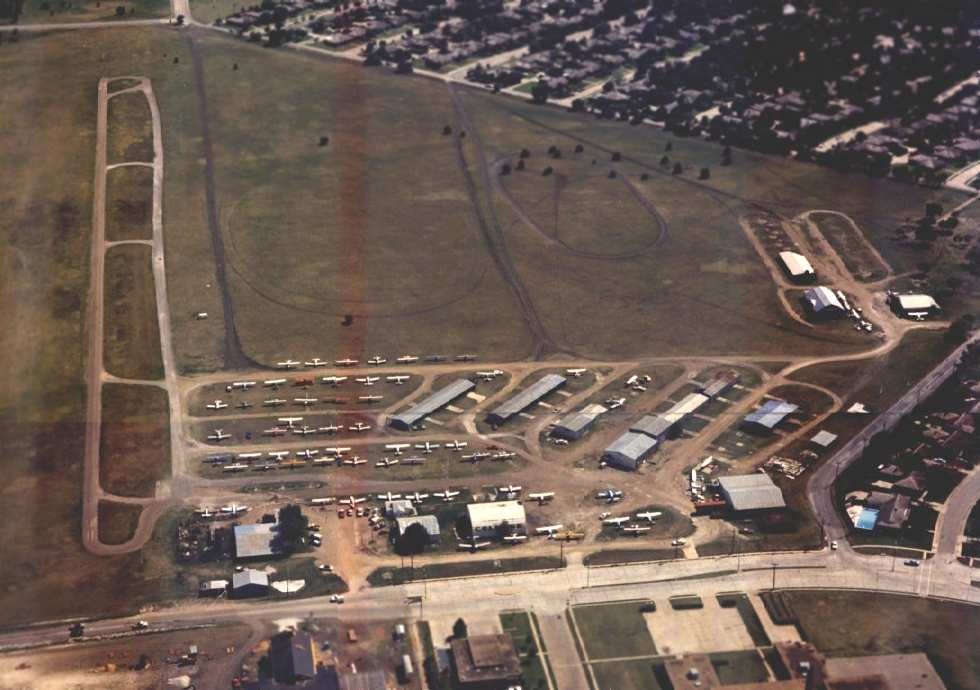
White Rock Airport (WRK), Dallas, TX
32.8, -96.69 (East of Downtown Dallas, TX)
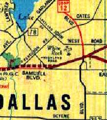
White Rock Airport as depicted on the September 1942 Dallas Sectional Chart (courtesy of Chris Kennedy).
Yet another small general aviation airport which was swallowed up by the growth of the Dallas urban area.
Dagley Reeves recalled, “My father [Morris 'Pappy' Reeves] started White Rock airport in 1941. I learned to fly there.
The man always present at the old airport was Wayne. He was my cousin & was the manager.”
However, White Rock Airport was yet not depicted on the February 1942 Dallas Sectional Chart (courtesy of Chris Kennedy).
The earliest depiction of White Rock Airport which has been located
was on the September 1942 Dallas Sectional Chart (courtesy of Chris Kennedy).
It depicted White Rock as a commercial airport.
A circa early 1940s aerial view looking northwest at the hangars of White Rock Airport,
from “not long after the start of operations” (courtesy of Dagley Reeves).
A 1943 aerial view looking east at White Rock Airport (courtesy of Dagley Reeves),
taken during “the one & only airshow ever held at the field.
The Old Man let a couple of girls borrow 2 Cubs to do a formation pass.
They collided & one of the pilots was killed.
After that neither Wayne (my cousin the manager) nor the Old Man would hear of any kind of airshow.
If you look closely you can see a P-38 the Air Corps brought for display.”
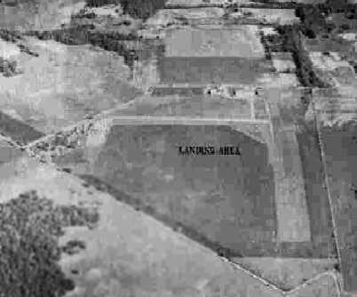
A 10/16/43 aerial view looking north from the 1945 AAF Airfield Directory (courtesy of Scott Murdock)
depicted White Rock Airport as having an east/west paved runway adjacent to a grass landing area,
with several buildings on the north side.
The April 1944 US Army/Navy Directory of Airfields (courtesy of Ken Mercer)
described White Rock Airport as having a 2,300' unpaved runway.
The 1945 AAF Airfield Directory (courtesy of Scott Murdock) described White Rock Airport
as a 97 acre irregularly-shaped property having 6 sod runways,
the longest being a 2,850' northwest/southeast strip.
The field was said to have a total of 6 hangars, the largest being a 65'' x 60' wood & metal structure.
White Rock Airport was said to be owned & operated by private interests.
White Rock Airport was described in article entitled "Private Airports" in the May 1947 issue
of the Dallas Chamber of Commerce Magazine (courtesy of Jeff Ferguson).
The aerial photo accompanying the article depicted several hangars,
but did not show the runway configuration of the field at the time.
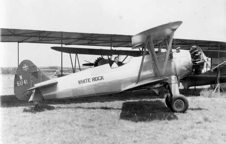
A circa late 1940s photo of a Stearman emblazoned with “White Rock” on the fuselage (courtesy of Dagley Reeves).
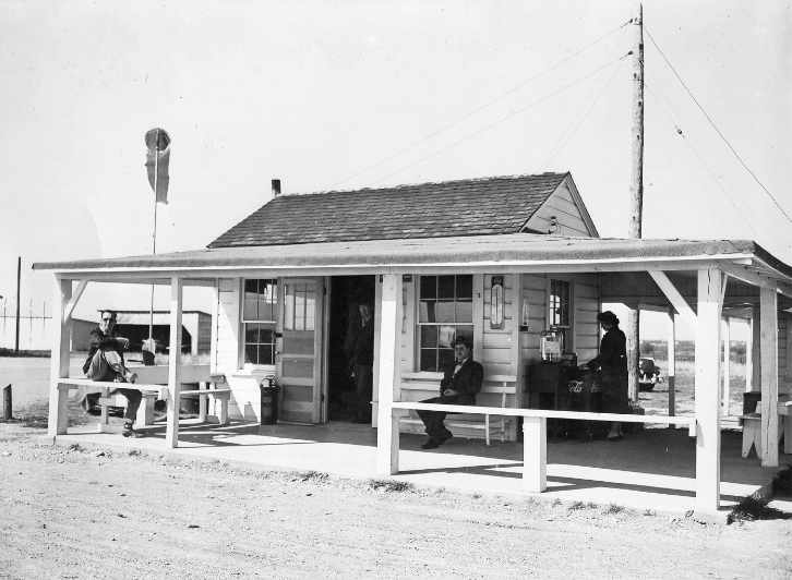
A circa late 1940s photo of the White Rock Airport line shack (courtesy of Dagley Reeves).
According to Dagley, “Although the grounds totaled more than 125 acres,
the epicenter was the porch & tiny shack where everybody hung out.
On the weekends the porch was the scene of countless domino games,
quarter tossing contest & if the Old Man was not around, a card game in the line shack.”
A circa 1940s photo of James McKey in front of several surplus WW2 planes at White Rock Airport.
The January 1948 Dallas Local Aeronautical Chart depicted White Rock Airport as having a 2,900' unpaved runway.
Several B-25 Mitchell bombers were reported to have landed at White Rock Airport in 1949.
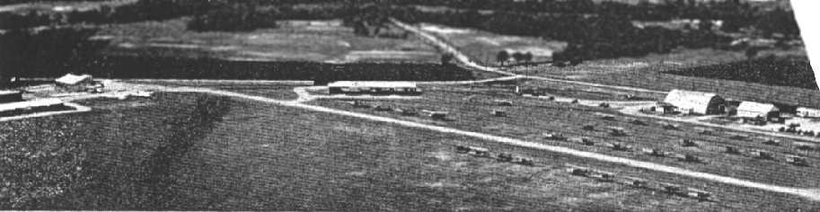
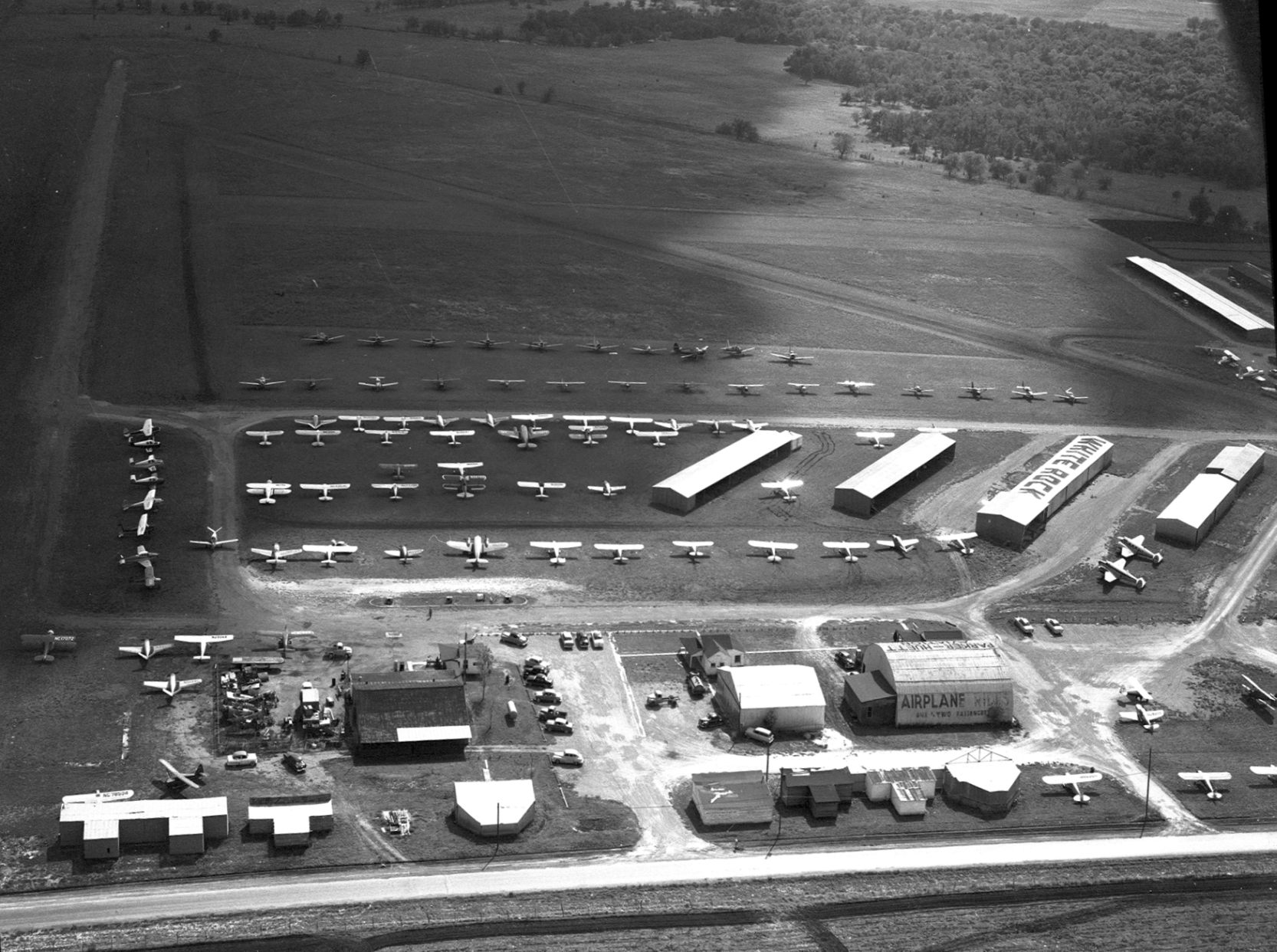
A March 1949 Barnes Aerial Surveys aerial photo (from the Dallas Department of Public Works Survey & Records Library, courtesy of Chris Walton)
depicted White Rock as having a north/south paved runway & 2 crosswind grass runways.
A large number of hangars & dozens of light aircraft were on the west & north sides of the field.
Sherry Dunn recalled, “My grandparents, Mr. & Mrs. C. R. Jannasch owned the property
(except for a portion that belonged to the airport) that the White Rock Airport was on.
You can see the fields nearby which my grandfather plowed.
My grandparents' house was directly behind the airport.
I used to walk up to some of the airplanes from the barn & look into some of the airplanes when I was little.
My grandmother caught me a few times & told me to stay away.”
A large number of hangars & dozens of light aircraft were on the north side of the field.
KG recalled, “When I was a kid [1956-57], just having moved into a new neighborhood, me & a buddy discovered White Rock Airport, a little uncontrolled field not far from my new home.
White Rock had some mothballed WWII aircraft that we could play in. Nobody ever bothered us & man oh man was it ever fun.”
Guy Johnson recalled, “I have very intimate knowledge of White Rock Airport.
I was a student at Skyline High School during its first 3 years of operation.
I spent 3 years turning wrenches & running up the old R-985s on that Beech 18; actually one of 2 we had out there.
We only had the Twin Beech there for our first semester while the ceiling on our hangar at the school was being fixed.
We were bussed from the school to the airport a few times a week to play with the airplanes.
I have a bunch of pics taken the morning after the big microburst that destroyed quite a few airplanes; in fact a pic of what was left of that short gas pump & the Cessna 210 I believe that was pushed sideways into it.”
A 1957 aerial view depicted White Rock as having a north/south paved runway & 2 crosswind grass runways.
A large number of hangars & dozens of light aircraft were on the west & north sides of the field.
Chris Walton observed, “Very little changed between 1949-57, other than the construction of several new hangars;
it's probably no coincidence that fewer airplanes were parked out in the open in 1958."
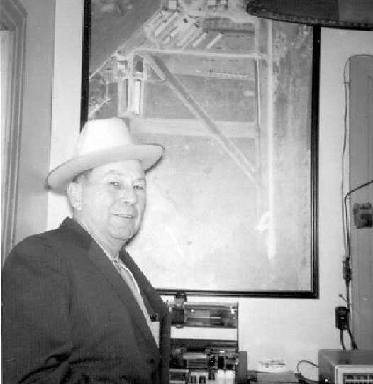
An undated photo of White Rock Airport owner Morris 'Pappy' Reeves in the line shack, in front of an aerial picture of the airport (courtesy of Dagley Reeves).
The 1959 USGS topo map depicted White Rock Airport as having 4 runways,
and 2 buildings on the north side of the field.
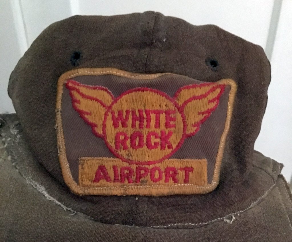
A 2016 photo by Scott Laminack of his circa 1959 White Rock Airport “ball cap I used to wear when I went flying with my father George Laminack.
It was a very old hat when Dad gave it to me.
Dad owned a Cessna 140 taildragger N90066 & had it tied down outside for many years.”
White Rock Airport, as depicted on a 1960 Humble Oil DFW road map.
The 1962 AOPA Airport Directory described White Rock Airport as having a 2,450' asphalt Runway 18/36
and 2 sod runways (2,100' Runway 13/31 & 2,000' Runway 9/27).
The operators were listed as White Rock Airport Inc., Turner Aviation School Inc.,
Aircraft Mechanics Service, Skyways Aviation Inc., and Aircraft Engines & Accessories.

The 1963 TX Airport Directory (courtesy of Steve Cruse) gave a slightly different runway configuration for White Rock,
with the primary runway being a 2,120' asphalt Runway 17/35,
and only one grass runway: a 1,600' turf Runway 8/26.
A total of 14 hangars & an office building were depicted along the northwest side of the airport.
The manager was listed as W.W. McWhirter.
Of White Rock Airport, Spike Cutler observed, "…Sad to lose, but it was always kinda crappy!
I recall that it was running over with decrepit & rotting aircraft
(I especially recall 2 Cessna Bobcat twins, 'Bamboo Bombers')."
Richard Wright recalled, “White Rock... 3/15/64: Late on a Saturday evening (11 PM) I took off from Abilene Municipal in my Swift to visit my Dallas lady friend.
When I arrived, the fire pots were not lit. With no moon, White Rock was a big black hole.
I recalled the approach from the south started at a highway intersection 3 miles out – so I made a low pass over what I figured was the runway.
No joy. But my lady friend saw my pass & understood the dark runway problem.
She maneuvered her car to the far end of the runway with the headlights pointing down the runway.
That was enough to make the next approach with landing lights for a successful landing.
The next morning, the airport manager explained that the fire pots normally lit each evening, were not that day as the winds were strong enough to blow them out.
Fortunately, there was a dead calm for my post midnight arrival.”
Brian Jones recalled, "I grew up across the street from White Rock Airport!
It was bounded by Lakeland Road to the North, Hunnicut (used to be Cox) to the West, St. Francis to the South, and Fields to the East.
The airport was very busy until the end."
John Price recalled, “White Rock Airport was the location of the White Rock Civil Air Patrol Squadron I belonged to in 1966 or 1967.”
Dennis Barnes sent in the following observations in 2003 "of White Rock Airport, which, after 37 years,
is still very fresh in my mind & dear to my heart."
"I lived near White Rock Airport while attending the 6th grade at George W. Truett Elementary School.
My parent's house, as well as my school, were sort of under the downwind approach to White Rock Airport.
Having an intense interest in aviation, I used to enjoy sitting in the back yard
and watching the aircraft go downwind & turn base to final for White Rock Runway 17.
My sense of curiosity & adventure finally inspired me to get on my bicycle
and find how to get to this busy little airport so I could see the aircraft up close.
I did... and I must say that I, along with my friend Billy Boulet,
became regular fixtures at White Rock Airport during 1965-66.
"After school & on weekends, hanging around White Rock Airport was our favorite pastime.
I have many fond memories of that Airport and, although nearly 50 years old now,
I still think of my days hanging around that airport as some of the best times of my life."
"I took my first airplane ride from Jimmy's Flying Service on White Rock.
They kept an old yellow Piper Cub right outside their door that had to be 'hand propped' to get started.
I remember they charged $9/hr solo & $14/hr dual in that aircraft. Rides were only about $5.
I saved my allowance & finally took the $5 ride.
'Jimmy' himself piloted my 'ride' & I remember at one point he turned the stick & rudders over to me
and asked if I wanted to fly the airplane. I was thrilled!
Not only was this my first flight in any kind of aircraft, but I got to 'fly' the airplane too!"
"Brown & Brown Aviation was right beside the approach end of Runway 17
and we used to love to stand at the fence in front of Brown & Brown
and watch the airplanes as they flew just a few feet above our heads while landing.
We'd also like to lazily sit on the porch near the fuel island, get a Dr. Pepper,
and just watch all the airplanes coming & going from there.
It was a tremendous thrill when a 'twin' or 'exotic' airplane would come in at White Rock.
I remember one day a Twin Commander landed at White Rock.
We became very excited about this because we thought it was a seaplane!"
"My buddy & I befriended several of the regular aircraft owners & pilots at White Rock.
We became friends with a free lance instructor, a Mr. Alexander,
who owned a 'straight tail' Cessna 172 there.
Sometimes, when giving instruction to a student, Mr. Alexander would ask the student if he minded,
and then would offer to let me & my friend sit in the back seat during instructional flights!
We also became friends with a dentist, Merlin Day,
who owned not only a Mooney M20, but a little single seat Mooney Mite (very rare) which he kept at White Rock.
Many times when locally flying the bigger Mooney he would let us 'ride along'.
I remember all the 'old aircraft' around the airport.
There was a decaying Stenson 'Flying Station Wagon', Luscombes,
even a Beech 18, and other aircraft which just seemed to sit tied down in the tall grass & never be flown.
And I remember some even older aircraft which sat in or near a hangar at the rear of the field which stayed very quiet.
I'll never forget all those adventures, riding my bike on the gravel taxiways & dirt roads which ran through White Rock Airport,
stopping to walk around an interesting aircraft & peer through the windows at the instrument panel & seats.
My family moved to Georgia in late 1966 & I never saw White Rock Airport again.
I've always wondered what happened to the busy & fascinating little airport."
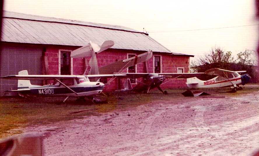
Mel Asberry recalled, “I soloed out of White Rock Airport in September 1967 with Scott Aero. Shortly thereafter bought a 1941 Taylorcraft & flew it out of there until it closed.
My T-hangar was the very last one on the southwest corner. I remember paying 48 cents/gallon for avgas.
Dale Milford [restored] a Globe Swift there... It was actually the prototype of the Buckaroo, basically a tandem Swift.”
Bill Sterling recalled, "In 1968, after serving with the US Army,
I returned to flight training with T. D. Brown, of Brown & Brown Aviation, White Rock Airport.
Runway 18/36 was only 12’ to 15’ wide asphalt & 2,100’ long,
with a parallel grass strip to the east, a parallel taxiway to the west,
and a very seldom used crosswind grass strip about mid-field.
The crosswind runway was very poorly maintained & questionably usable even for emergencies.
I don’t remember ever seeing it used."
Tom Bria recalled, “I worked as a flight instructor for Brown & Brown Aviation at White Rock Airport during 1968 & 1969.
T. D. & Mrs. Brown were fine people & took me in as I waited for my USAF Officer Candidate Class to begin.
They really didn't need another CFI, as the weather in the winter of 1968-69 was terrible,
so much time was spent hanging around the office or heading off to Samuels Street for finer entertainment, courtesy of T.D. Brown.
Operating out of White Rock was tricky, with John West Road at the north end of the runway (final approach needed to be timed between auto traffic)
and the high tension power lines at the south end.
T. D. was very proud of his Piper Apache & delighted in flying it out of White Rock.”
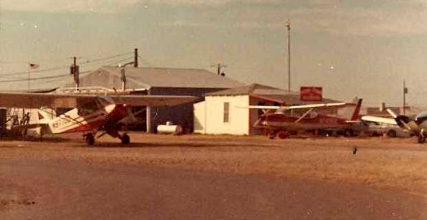
A July 1969 photo by Tom Bria of White Rock Airport, showing “the Brown & Brown building
and 3 airplanes we operated from there in 1968-69: a Piper Supercub, a Cessna 172, and half of T.D.'s beloved Piper Apache.”
Bill Sterling recalled, "Housing developments were crowding in from the west with apartments & commercial to the east also.
White Rock Airport was destination for many aircraft during the State Fair & OU Weekend.
But the short narrow strip was a bit intimidating, however,
for those pilots with larger home base operations.
Landing short & even bouncing off vehicles running east west on John West Road was the norm.
Dale Milford, retired USAF, local TV weather personality & Congressman, lived a few blocks away from the airport.
Milford restored a Globe Swift in his garage.
For test flights during reconstruction he would taxi up the street to the airport.
There were a couple of Stearman aircraft used to tow banners off the grass there often
and not unusual to see a DC-3 come in for repairs at Shorty’s.
I frequented the airport through 1973."
David Meyer recalled of White Rock Airport, “I earned my private license at Brown & Brown in January 1970.”
An 11/15/70 USGS aerial view depicted White Rock as having a north/south paved runway,
with a large number of hangars & dozens of light aircraft on the west & north sides of the field.
David Meyer was one of the pilots involved in an accident at White Rock, on 4/17/72,
in which one Piper 140 landed on top of another Piper 140.
David recalled, “I was in the 'bottom' Piper & sustained only minor injuries, with Mr. Ward's propeller narrowly missing my head.
I remember that day well. I still have the front page photo from the Dallas Times Herald.”
A circa-1972 photo by Ken Adwan of a Stearman at White Rock.
Ken recalled, "The Stearman was one of the old airplanes… at the back of the airport.
However, unlike many of the old planes at that end of the field, it was very airworthy when this picture taken.”
Russell Bowen recalled, “The Stearman belonged to a fellow named Mott Walters; he had 2 of them, a black & red one."
A circa-1972 photo by Ken Adwan, looking taken looking southeast from the tiedowns just east of the runway.
Ken recalled, "This particular Twin Beech (a C-45 military version of the 18) was not a regular at White Rock.
This airplane is now apparently a maintenance trainer at Skyline High School.”
Russell Bowen recalled, “The Beech 18 is at Skyline, I was a student there,
and remember taking the wings off & towing it to the school.
It was done on a Saturday morning 1972 I believe, and it was a cold one at that!!"
A circa-1972 photo looking southeast at the fuel island at White Rock Airport, by Ken Adwan.
The last aeronautical chart depiction which has been located of White Rock Airport
was on the February 1973 Dallas Sectional Chart (courtesy of Ron Plante).
It depicted White Rock as having a single 2,100' paved north/south runway.
An aerial view of White Rock Airport looking south in 1974, just prior to its closing.
Photo is by longtime Dallas area flight instructor Paul Bartlett, courtesy of Ken Adwan.
Ken Adwan recalled, "I began my love affair with airplanes while attending Conner Elementary School
which was built across John West from White Rock Airport in 1965.
My first grade class was perfectly situated for viewing aircraft landing on Runway 17."
Russell Bowen recalled, "I lived my early teen years at this airport & knew the Bartletts very well.
I was a close friend of Don Bartlett's son, Perry.
I also knew a mechanic called 'Shorty'. He had a hanger over off Hunnicut.
I also spent many hours watching Dr. Swaze & Dale build those AT-6's.
I spent many lazy summer days sitting on the 'flightline' with Mr. Bartlett
in their yellow & white 1957 Ford Fairlane or his van, or under the wing of Dr. Swaze's T-6.
At night we use to watch the Buckner theater from the flightline.
I also remember the famous Cherokee landing on top of the Cessna event!! WOW scarieeeeeeee.
I worked for a short time for Talon Aviation.
I believe there was a aircraft rental company called Aeroscott,
Don Bartlett rented a Yankee Clipper & asked me if I wanted to go flying,
well on a hot summer day with a 250lb man & a 195lb teenager onboard,
it took all the runway & seat puckering to get it in the air!! Never do that again!
I wish I had time to recall all the adventures we had as youths at that grungy old airport,
but it was the best of times."
A 1974 photo by Blake Pursur of tornado damage at White Rock Airport, including several wrecked aircraft.
White Rock Airport, as depicted on a 1974 Rand-McNally DFW road map.
Dagley Reeves recalled, “We owned the airport until its close in the 1970s.”
Ken Adwan recalled, "Regrettably, the little airport closed [in 1974] about a year prior to the start of my flying lessons.
The hangars near the corner of [Hunnicut] & St. Francis were my favorite part of the airport.
Back in the 1960s, they contained dusty, derelict old remains of airplanes that would bring a handsome fortune today.
I have had a recurring dream for the past 20 or so years
that I am driving past the old airport site & this part of the airport still remains.
On a couple recent trips to Dallas I drove by there to prove to myself that I was just dreaming."
Bill Sterling recalled, "Airport Manager Bill McWhirter was in poor health
and real estate development in the area forced the airport to close around 1974/75."
Sherry Dunn [granddaughter of the airport property owner] recalled,
“I remember finding out that the airport was paying my grandfather only $100 a month in rent
and had been doing this for years & the taxes kept increasing.
He never raised the rent. So I take it my grandfather was not a very astute businessman.
I understand my aunt raised the rent at the airport (the taxes were more than the rent received);
however, I believe the offer was refused or something happened.
I do remember there was a family meeting & the family voted to sell the property. It was sold to Fox & Jacobs.”
Brian Jones recalled, "It was replaced by a Fox & Jacobs development in the mid-1970s
and a city park on the southwest corner."
White Rock was depicted as "Closed" on the January 1976 Dallas Sectional Chart (according to Bill Sterling).
By 1976 part of the property had been redeveloped as White Rock Village, a residential development.
According to resident Sandra McNabb, street names in this neighborhood reflect the former airport:
Lindbergh, Rickenbacker, Grumman, Cessna, O'Hare.
Lesia Yancey recalled, “I grew up on Sikorski Street, in a Fox & Jacobs home built in 1977 on the very site of the old airport.
I heard as a child that our neighborhood used to be an airfield,
but I never knew that is was such a short time between the demise of the airport & the development of the homes.
I was in 2nd grade when we moved there & I still remember digging up some weird part or piece of metal when I dug tunnels in the back yard.
Wish I would’ve kept them!”
By the time of the 1978 DFW Sectional Chart (courtesy of Ray Brindle),
White Rock Airport was no longer depicted at all (not even as an abandoned airfield).
Troy recalled, “White Rock Airport: About 1978 a group of friends older than me were into aviation.
One of them had a father who kept his plane at White Rock until it closed. Several years later I would be playing soccer on the old site!”
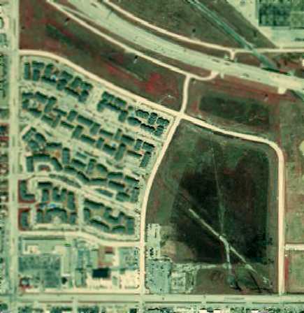
A 1979 aerial view showed that housing had covered the property, with not a trace remaining of the former White Rock Airport.
Brian Jones recalled, "If you walk on the northern side of the park,
you can still see where the hangar posts were set in concrete (the 'evil' developers left a trace after all!)."
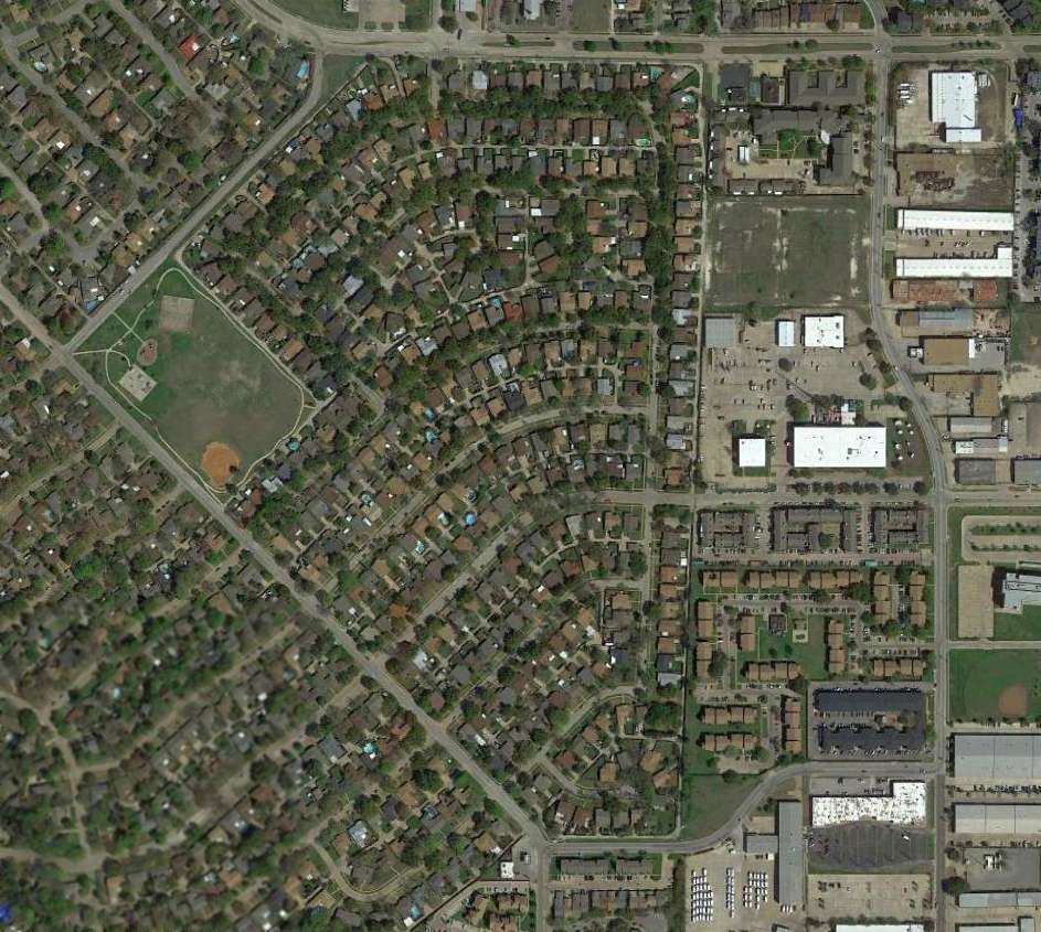
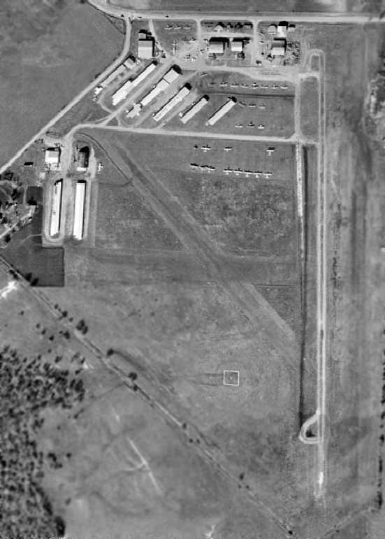
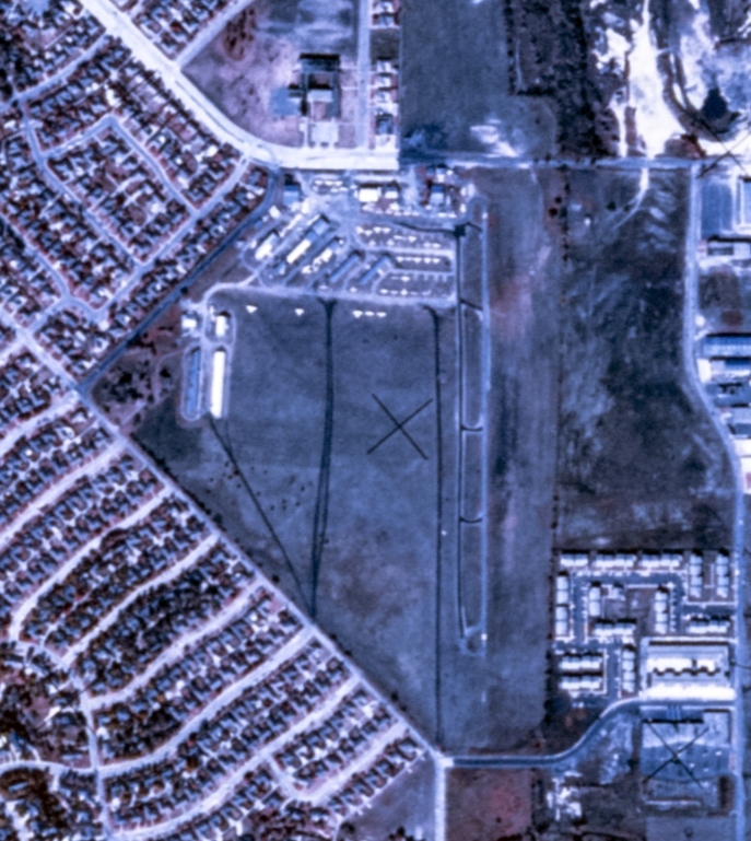
A 2015 aerial photo shows no trace remaining of White Rock Airport.
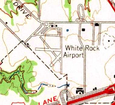
The site of White Rock Airport is located northwest of the present-day intersection of Interstate 30 & North Buckner Blvd.
___________________________________________________
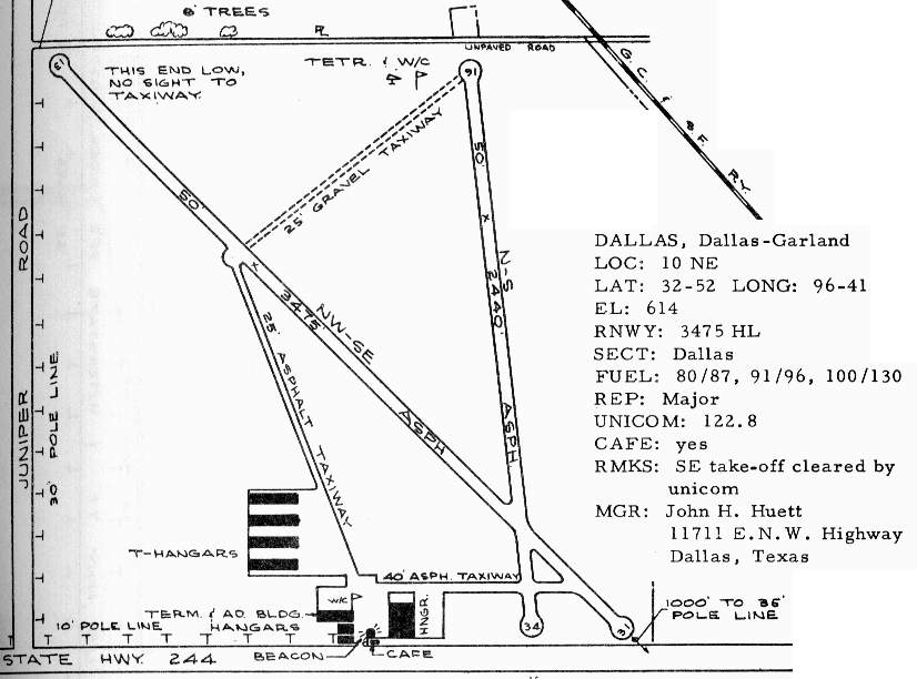
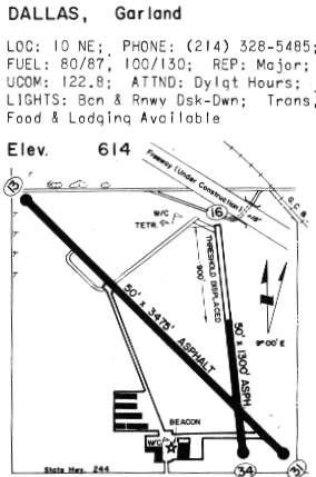
Dallas Hudson Airport / Dallas-Garland Airport, Dallas, TX
32.87, -96.68 (Northeast of Downtown Dallas, TX)
A 1942 aerial view of Dallas Hudson Airport.
Dallas Hudson Airport was apparently built at some point between 1937-40,
as it was not yet listed among active airfields in the Airport Directory Company's 1937 Airport Directory (courtesy of Bob Rambo).
The earliest reference to Hudson Field which has been located
comes from Lonnie Wiggins, who provided logbook entries from his father, Harvey Wiggins,
who flew from 'Hudson Field' starting in October 1940.
The logbook references to "Hudson Field" lasted until July of 1941,
when the first reference to "Hudson Airport" showed up (the significance of that change is unknown).
The earliest photo that has been located of Dallas Hudson Airport was a 1942 aerial view.
It depicted Dallas Hudson as having a paved north/south runway,
with a paved taxiway leading to a hangar & several small aircraft on the south side.
A photo of E.V. Lohberg, W.A. Dorris, and H.W. Wiggins preparing for a Civil Air Patrol flight from Hudson Airport
from the 1/25/42 issue of the Dallas Times Herald (courtesy of Lonnie Wiggins).
The caption read: “Air Patrol leaders prepare for secret flight.
Two flights of the Civil Air Patrol will take the air Sunday under sealed orders.
E.V. Lohberg, squadron leader; W.A. Dorris, group commander for the Hudson Airport unit,
and H.W. Wiggins, flight leader, are preparing for any direction the sealed orders may take them.”
The earliest aeronautical chart depiction of Hudson Airport which has been located
was on the February 1942 Dallas Sectional Chart (courtesy of Chris Kennedy).
It depicted Hudson as a commercial airport.
A 10/15/43 aerial view looking north from the 1945 AAF Airfield Directory (courtesy of Scott Murdock)
depicted Hudson Airport as an square grass area within which was a north/south grass runway.
The April 1944 US Army/Navy Directory of Airfields (courtesy of Ken Mercer)
described Hudson Airport as having a 2,000' unpaved runway.
The 1945 AAF Airfield Directory (courtesy of Scott Murdock) described Hudson Airport
as a 250 acre square-shaped property having a single 1,725' gravel & asphalt north/south runway,
along with a 2,600' square sod all-way area.
The field was said to have 2 wood & metal 120' x 60' hangars.
Hudson Airport was said to be owned & operated by private interests.
The January 1948 Dallas Local Aeronautical Chart depicted Hudson Airport as having a 1,700' paved runway.
A March 1949 Barnes Aerial Surveys aerial photo (from the Dallas Department of Public Works Survey & Records Library, courtesy of Chris Walton)
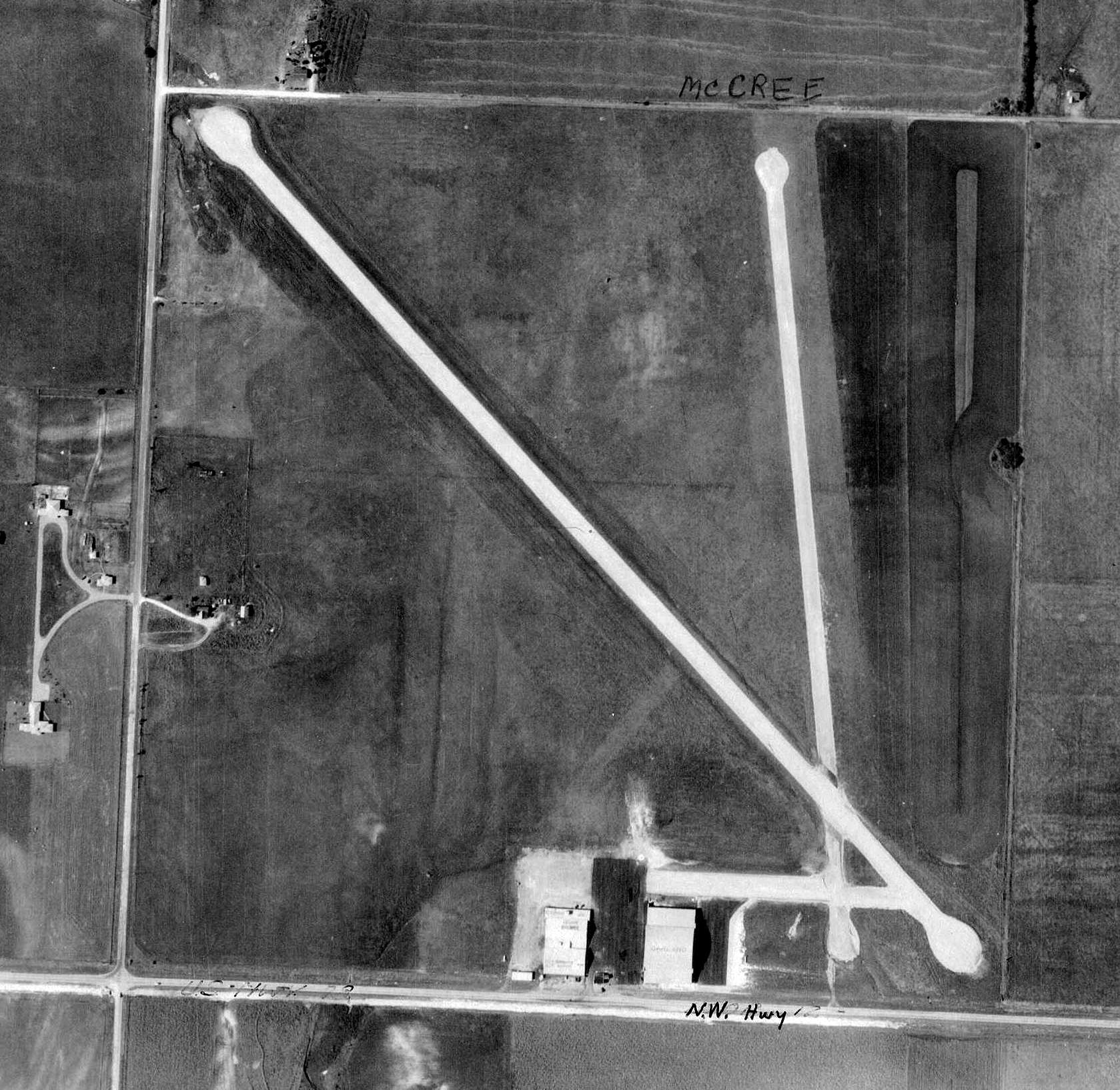
depicted Dallas Hudson Airport as having 2 paved runways, and 2 hangars on the south side of the field.
No aircraft were seen on the field.
John Price recalled, “I got my very first airplane ride here in 1950 or 1951 in a J-3.
My dad was the CO of the Garland CAP Squadron & they bought 2 J-3s for $800.”
A 4/1/52 USGS aerial photo depicted Dallas Hudson Airport in the same configuration as seen in 1949.
However 4 aircraft were visible on the field, including one larger twin-engine aircraft.
A 1957 aerial photo depicted Dallas Hudson Airport as having 2 paved runways.
Two hangars were located on the south side of the field,
and a total of 5 light aircraft were visible on the south & west sides of the field.
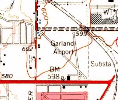
The 1959 USGS topo map depicted Garland Airport as having 2 runways, and 2 buildings on the south side of the field.

By 1960, it had been renamed Dallas "Garland" Airport, as that is how it was depicted on a 1960 Humble Oil DFW road map.
Dallas Garland Airport was described in the 1962 AOPA Airport Directory
as having 2 macadam runways (3,400' Runway 13/31 & 2,800' Runway 16/34).
The operators were listed as Texas Airmotive Co. & Wings Inc.
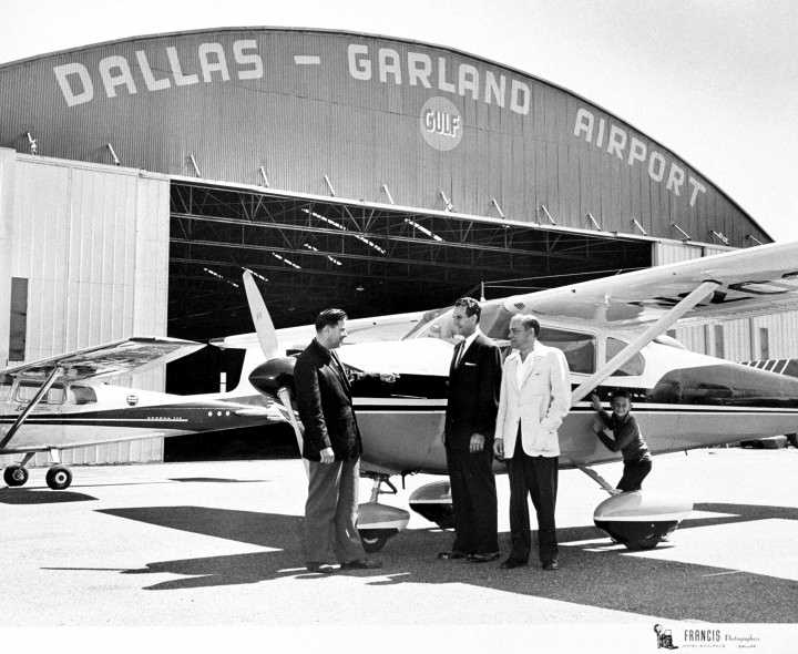
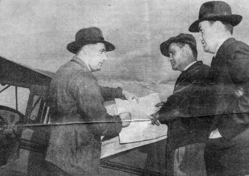
A circa 1962 photo of Garland Airport operator John Huett greeting Congressman Bruce Alger
in front of a Cessna 1982 with a Dallas-Garland Airport hangar in the background.
Gary Walker recalled, "My experience with this field began in around 1962, when my Father assumed the operation(s) as owner.
Upon the ownership assumption of this field, my family performed extensive renovations on the field & property.
Among, but not limited to, these renovations consisted of complete ramp & parking area resurfacing,
extensive updating of the main terminal, the installation of 2 mobile refueling vehicles to replace the existing drive up pump facility, runway resurfacing & lighting.
I recall these projects as quite extended.
There were many businesses located on the airport property, some related to flying, some not.
My family also had a used car dealership on the property during the initial stages of takeover."
The 1963 TX Airport Directory depicted Dallas-Garland as having 5 hangars & a terminal building at the south side of the field,
and listed the manager as John Huett.
Dallas Garland Airport had a strange moment in the spotlight
as part of the mysterious events surrounding the assassination of President Kennedy in Dallas.
Robert Plumlee (who had piloted clandestine flights for the CIA for over 31 years)
testified before the Senate Foreign Relations Committee in 1990 & 1991.
Plumlee testified that on 11/22/63 he was a co-pilot on a top secret flight supported by the CIA.
The flight carried Philippe Socko (a known Mafia/CIA double operative) from Florida to Dallas,
and that their assignment was to stop the assassination attempt on Kennedy's life.
Plumlee stated that Roselli departed the plane at Dallas Garland Airport on the morning of November 22.
According to Gary Walker, his father continued as the airport operator "until his death in late 1966.
At that point, my Mother inherited the operation, which she ran up until about 1969-1970.
Doak recalled, “Circa 1968 I remember Texas State Optical's A-26 at Dallas-Garland Airport.
It was converted cabin, and BLACK.”
Tom Cone recalled, “Texas United Flyers [was] the FBO & flight school I worked with
as Flight Instructor & Airport Manager from 1968-72.
The owner of the operation at the time was Ferris O'Dell.”
As seen in the 1970 TX Airport Directory (courtesy of R.L. Brindle),
Garland's Runway 16/34 lost 1,000' of its length was the new LBJ Freeway cut across its northern end.
Matthew Bailey recalled, “Hudson Airport... Dallas’ largest model airplane club had circles for control-line aircraft built next to the airport, on the East side.
It was near the clump of trees which contained a dead airplane long before the airport was closed,
as that fuselage (and bits of wing, still) appeared there not long after 1970-71.
In the 1970s, radio control airplanes we’re beginning to be nearly affordable,
and they began lobbying the airport for a time-slot in which they could fly them over the area to the East of the airport,
which would have, we argued, 'kept them out of the approaches to the runways.'
They would not relent, as apparently the FAA was still in the throes of debate about R/C aircraft, and how close they could operate to working airports.
I know some guys began flying without permission on Sundays, with the few R/C airplanes that then existed in Dallas,
but a few years later, the airport closed, and the club laid-down a runway for R/C planes, and began flying every weekend.
The R/C runway operated for about 5-6 years.”
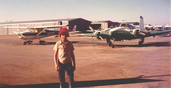
Ken Adwan at the Dallas Garland Airport, circa 1972.
"The view is looking northwest toward the T-hangars from the ramp adjacent to NW Hwy.
When I was young, my dad would take me to White Rock & occasionally Dallas-Garland to look at planes."
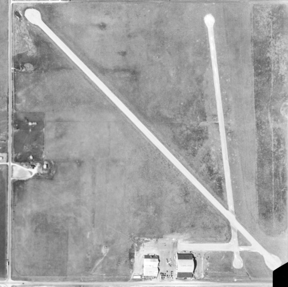
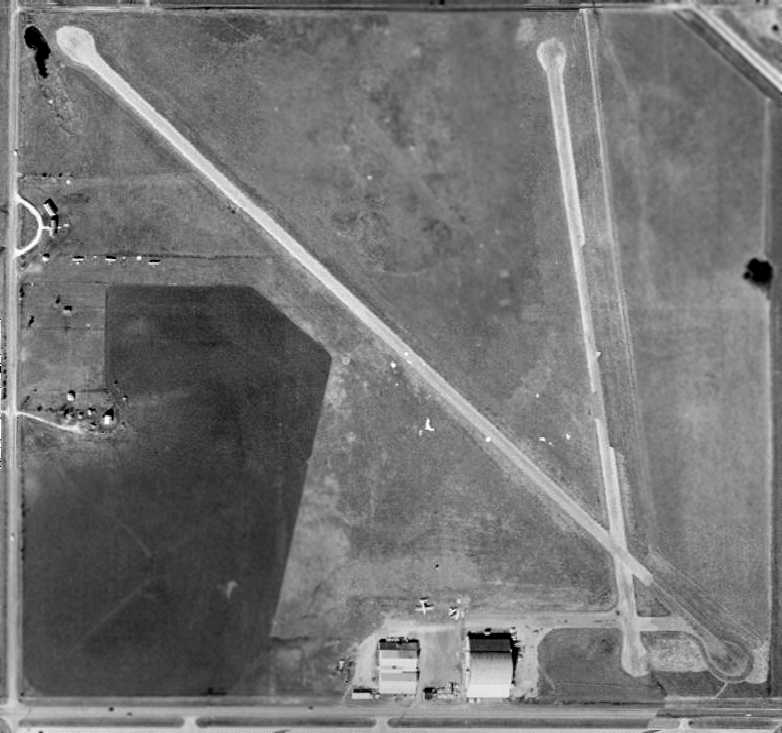
A 1972 aerial view depicted Dallas Garland Airport toward the end of its lifespan.
The small buildings previously seen on the west side of the field in the 1957 aerial view were gone.
The field was evidently well-used right up to the end,as there were dozens of light aircraft parked on the south side of the field.
Troy recalled, “Dallas-Garland Airport: In the early 1970s Jupiter Road was only 2 lanes.
Around 1972-73 a plane on final [approach] clipped a passing car. This was on the Northwest/Southeast runway.
The car was on Jupiter Road. Maybe this is why Hudson was closed in the same time period.
In the 1974-76 period it was a great place to ride motorcycles.”
Spike Cutler recalled that "Dallas - Garland Airport was doomed when Runway 16/34 was rendered unusable by the opening of LBJ Freeway / I-635,
which runs east-west across the northern edge of the property (I think the airport actually gave up some of Runway 16/34 to the freeway).
I had the good fortune of 'hanging around' Dallas-Garland (or 'Garland' as we called it, creatively) when growing up,
since I had a neighbor 2 doors down who owned an operation
which performed aircraft & helicopter (or 'heelicopter' as he called 'em) repair & renovations at Garland."
The last aeronautical chart depiction which has been located of Dallas-Garland Airport
was on the February 1973 Dallas Sectional Chart (courtesy of Ron Plante).
It depicted Dallas-Garland as having 2 paved runways, with the longest being 3,500'.
Reagan Moon recalled of Dallas Garland Airport, “ I just looked at my log book from back then, and my last flight there was 8/15/73.
It was my last solo flight before going to boot camp.
The entry right before that was a dual instruction flight with Tom Cone as my instructor on 8/6/73.”
Mel Asberry recalled, “Dallas Garland Airport: I was among the last airplanes to leave on 6/10/74 when it was closing. I moved my 1946 Globe Swift GC-1B to Seagoville.”
According to Tom Cone, “I hold the dubious honor of flying the last 'official' airplane (Mooney)
off the airport when the operation was moved to the Dallas North airport, then considered far out in the country.
I'm continually surprised to find that most people, even those who have lived in the area for a long time,
never knew there was an airport there!”
Reagan Moon recalled, “I remember visiting home back in early 1974
and found out to my dismay that the field had been closed down & had trenches cut across its main runway.
I still have a chunk of the runway I picked up that day. So the airport closed down somewhere between 1973-74.”
By 1978, the site of Dallas Garland Airport was depicted as an abandoned airfield on the DFW Sectional Chart (courtesy of Ray Brindle).
Troy recalled, “In the 1978-81 period our mother would drop us off to shoot B.B. guns there.
In the Northeast corner of the property were a clump of trees. My brother & I were amazed to find an airplane there!
The fuselage & wings were intact, but it had no landing gear or windows. The interior was mostly stripped out of it.”
A 1979 aerial view showed that all of the hangars had been removed, but the runways were still intact.
Roads had been built over the southwest corner of the former airport property.
Jason Martin recalled, “I remember a twin-engine plane making an emergency landing
on the remains of the old Garland field where apartments are now.
He had to hop over the trenches that were dug across the runway to prevent it from being used as a dragstrip.
He finally dug in on the 4th trench since his airspeed wasn’t sufficient to get up over the trench.”
Troy recalled, “In the mid-1980s the trees & plane were removed & the soccer fields were put in.”
A 1989 aerial view showed that residential construction had covered the west half of the airport property,
but portions of both runways & the former ramp were still visible on the east side.
Spike Cutler noted, "If you were to come to the site with me now,
I could show you a little bit of recognizable remaining evidence, but you'd have to have been there to recognize it;
the paving & bushes which stood in front of the operations building remain.
In the aerial photo, you can kind of see 'em between the Fry's store & NW Highway."
A 2015 aerial photo shows the site of Dallas Garland Airport is the location of a Fry's, Sam's Club, car dealerships & housing developments.
The site of Dallas Garland Airport is located northeast of the intersection of Jupiter Road & East Northwest Highway.
___________________________________________________
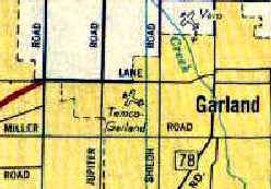
Luscombe / Temco Garland Airport, Garland, TX
32.9, -96.68 (Northeast of Downtown Dallas, TX)
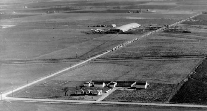
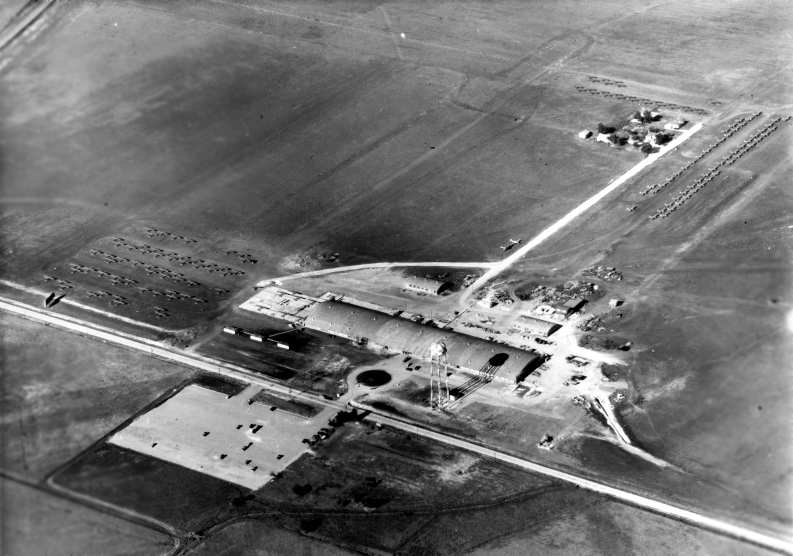
A circa 1945 aerial view looking south down Jupiter Road at Luscombe's Garland Field (courtesy of Ron Nielsen),
soon after the first hangars were built, with Forest Lane in the foreground.
This airfield is not to be confused with the Dallas-Garland Airport,
which was a separate field located 2 miles to the south.
According to Tom Beamer, this facility was originally a government owned plant, built during WW2
"for the production of Guiberson Diesel Radials (A-1020 for aircraft, T-1020 for tanks).
When the Army decided to simplify supply lines & only use gas engines
the plant was turned over to Continental for license production of a tank version of the Wright R-975,
which Continental continued to produce after the war as the R-9A."
After the war, the Garland plant was reused by the Luscombe company as an aircraft factory.
According to John Bradberry, Luscombe relocated in 1945
from Trenton, NJ, to Garland to take advantage of cheap labor.
As seen in the above 1940s photos, Luscombe used the large arched-roof hangar
(along with several smaller hangars to the east)
to build the Luscombe Models 8A, 8D, 8E, 8F, T8F, and 11A from 1945-50.
Production of Luscombe Silvaires peaked at 21/day, with as many as 250 on the field at some times.
The date of construction of the airfield adjacent to the Garland factory has not been determined,
but it was presumably constructed by Luscombe when they began use of the site.
No airfield at this location was yet depicted on the March 1946 Dallas Sectional Chart.
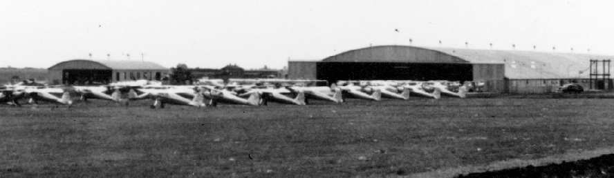
A circa 1940s aerial view looking northeast at Luscombe's Garland Field (courtesy of Ron Nielsen),
with a huge number of newly-built aircraft sitting on the field north & east of the hangars.
A circa 1940s view looking southeast at the huge number of newly-built Luscombes awaiting delivery at Garland (courtesy of Ron Nielsen).
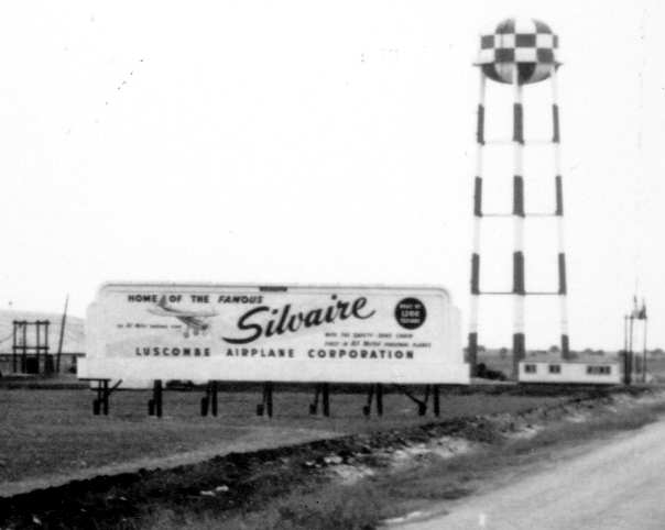
A circa 1940s view looking southeast at the billboard in front of Luscombe's Garland factory (courtesy of Ron Nielsen).
Luscombe Airport, as depicted on the March 1947 Dallas Sectional Chart (courtesy of Chris Kennedy).
The January 1948 Dallas Local Aeronautical Chart depicted Luscombe Field having 2 paved runways, with the longest being 5,000'.
John Price recalled, “My family moved to Garland in 1949.
At the time, Luscombe was in the throes of bankruptcy & there were hundreds of new Luscombes parked outside the big hangar.
My Dad said they were selling them for pennies on the dollar. My Mom still wouldn’t let him buy one.”
Luscombe declared bankruptcy in 1950,
at which point it was acquired by the Texas Engineering & Manufacturing Company (TEMCO).
At that time, Luscombe was no longer building civil airplanes,
but doing defense work such as building elevators, rudders, and bomb bay doors for the B-36 bomber
(assembled nearby in Fort Worth by Convair).
By 1953, the facility was called Temco-Garland.
The 1954 USGS topo map labeled the airfield as Garland.
In 1955, the Temco-Garland facility was producing major assemblies for the C-123, C-130, Electra, F3H & F-100.
A 1956 aerial view depicted the Temco-Garland Airport as having a single north/south paved runway.
In marked contrast to the earlier photos, not a single aircraft was visible on the field.
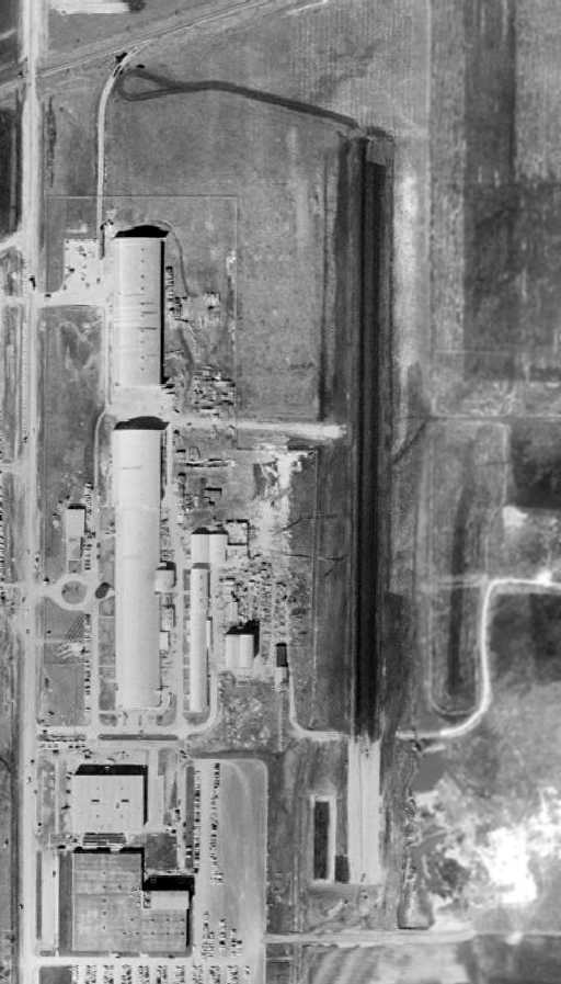
A 1957 aerial view depicted the Temco-Garland Airport as having a single north/south paved runway.
Not a single aircraft was visible on the field.
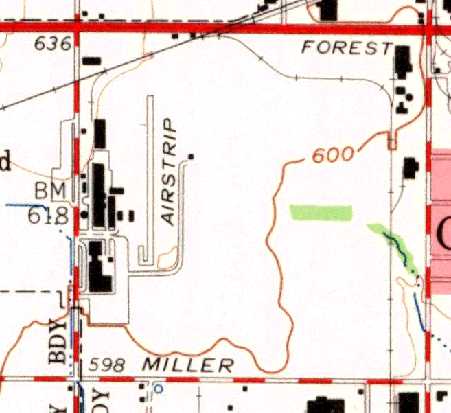
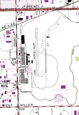
The 1959 USGS topo map depicted a single north/south runway, labeled simply as “Airstrip”,
along with the factory buildings on the west side of the field.
Temco-Garland Airport, as depicted on a 1960 Humble Oil DFW road map.

A circa early 1960s aerial view looking northeast at TEMCO Garland Field, with Jupiter Road on the left (courtesy of Ron Nielsen).
Several other large industrial buildings had been built on the site, adjacent to the original Luscombe hangar,
but there was no aircraft-related production activity.
The runway still remained intact, east of the industrial buildings.
Tecmo-Garland Airport was listed in the 1963 TX Airport Directory,
along with the remark "Private; emergency use only."
The field was described as having a 2,560' hard-surfaced runway,
and the manager was listed as Temco Electronics & Missiles Company.
The 1969 DFW Sectional Chart (courtesy of Ron Myres)
depicted “LTV Garland” as a private field having a single paved 2,500' north/south runway.
A 1972 aerial view showed that an antenna test facility had been added
at some point between 1957-72 adjacent to the northeast side of the runway.
Both of the former Luscombe arch-roof hangars still remained standing.
The February 1973 Dallas Sectional Chart (courtesy of Ron Plante)
depicted Garland as a private airfield having a 2,500' paved north/south runway.
John Price recalled, “Temco became part of LTV & during the 1970s the company ran a shuttle among their plants using an Aero Commander.”
A circa 1970s photo looking northwest at the antenna test facility (courtesy of Ron Nielsen).
The north end of the runway is visible immediately behind the building.
According to on Nielsen (who has worked at the Garland facility for 25 years),
the complex which was built adjacent to the northeast side of the runway was an antenna testing facility.
"Antennas & receivers can be placed out on the little runway/sidewalks,
and people can work in the building to test how well the devices pick up radio/radar signals
that are transmitted from the building.
During this time this facility did a lot of antenna work,
including building the Very Large Array antennas in New Mexico (often seen in movies).
Also we rebuilt & upgraded the Arecibo dish in Puerto Rico,
as well as many other large communication systems."
USGS topo map 1973.

By 1978, after a corporate acquisition, the field was depicted as E-Systems Garland on the July 1978 Dallas Terminal Chart.
A 1979 aerial view depicted the runway as remaining completely intact.
The northern former Luscombe arch-roof hangars still remained standing,
but the southern hangar had been removed at some point between 1972-79.
However, the airfield itself was closed prior to 1982, as the following story points out.
Ken Adwan sent in a fascinating story about what was surely
the last aircraft to land & takeoff at Temco-Garland Airport.
"In August 1982, I was an engineering intern working at E-Systems in Garland.
E-Systems Garland was formerly LTV & before that Temco.
I worked in a small building just off the north end of the old runway there.
By that time the airport was of course closed
and a new electronics lab building had been constructed right in the middle of the runway.
One afternoon, I & several other employees heard a commotion outside & went to investigate.
We discovered an airplane (a 1969 Swearingen SA-26T Merlin)
had just landed on the one thousand or so feet of runway to the north of the new lab.
It had come to a stop just inches from the building.
The aircraft, a Merlin turboprop twin, had run out of fuel while enroute from Atlanta to Love Field.
The pilot, while demonstrating an apparent lack of flight planning skills, made what I consider an heroic dead stick landing.
His passengers were shaken, but unhurt."

The last aircraft departure from Temco Field, a 1982 photo by Ken Adwan.
The takeoff run began with the aircraft "backed all the way up to the lab building that was situated right in the middle of the closed runway.
The aircraft had stopped about 15' short of the building on landing."
Note the dust being kicked up by the Swearingen Merlin's static runup.

A 1982 photo by Ken Adwan of the Swearingen Merlin takeoff run.
The arched-roof hangars originally used as the Luscombe factory are visible in the background.

The last plane to takeoff from Temco Field - a 1982 photo by Ken Adwan.
Ken Adwan continued, "Two days later, with 2 new main landing gear wheels & tires & minimal fuel,
the chief pilot of the Georgia company that owned the aircraft flew it out & completed the trip to Love.
I clicked off about a dozen pictures of what will surely be the last aircraft departure from Temco Field."
Jim King recalled, "I can also vouch for the story about the last plane to land at TEMCO-Garland Airport.
I joined E-Systems in Garland in 1978 (and still work there - now Raytheon),
and I recall the commotion caused by that plane making an emergency landing.
The E-Systems facility was cleared for high security by DoD.
The guards carry guns, and that day, many of them were certain that the Russians had just landed in our back yard!
I also remember a lot of speculation about how they would get the plane out of there.
Taking off to the north, they had to clear power lines along Forest Lane.
Not only did this mean a minimum fuel load, but because it is very hot in Dallas in August, they flew it out at dawn."
The E-Systems Garland Airfield was depicted as an abandoned airfield on the January 1984 Dallas Sectional Chart.
By the time of the 1986 USGS topo map, the Temco runway was still depicted, but was labeled simply "Landing Strip".
A 1989 aerial view showed a marked change in the facility compared to the 1979 photo.
Almost the entire length of the runway was gone, with buildings & parking lots covering it.
The former Luscombe arch-roof hangar had been removed at some point between 1979-89.
The former antenna test facility on the northeast side of the runway had been removed,
but a very similar antenna test facility had been built to the south, adjacent to the former southeast end of the runway.
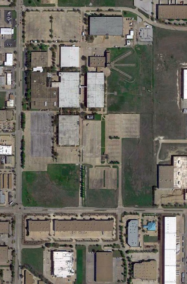
A 2015 aerial view showed the former Luscombe factory buildings were removed at some point in the past,
having been replaced by more modern industrial buildings & their parking lots.
The former runway was also gone, although it appeared as if an internal road inside the complex was built over the former runway.
Three paved sections of the former antenna test facility were still visible on the northeast side of the complex.
The Temco Field site is located northeast of the intersection of South Jupiter Road & Miller Road.
____________________________________________________
Or if you prefer to contact me directly concerning a contribution (for a mailing address to send a check),
please contact me at: paulandterryfreeman@gmail.com
If you enjoy this web site, please support it with a financial contribution.
____________________________________________________
This site covers airfields in all 50 states.