
Abandoned & Little-Known Airfields:
Texas: Southern Dallas area
© 2002, © 2025 by Paul Freeman. Revised 12/7/25.
This site covers airfields in all 50 states: Click here for the site's main menu.
____________________________________________________
Please consider a financial contribution to support the continued growth & operation of this site.
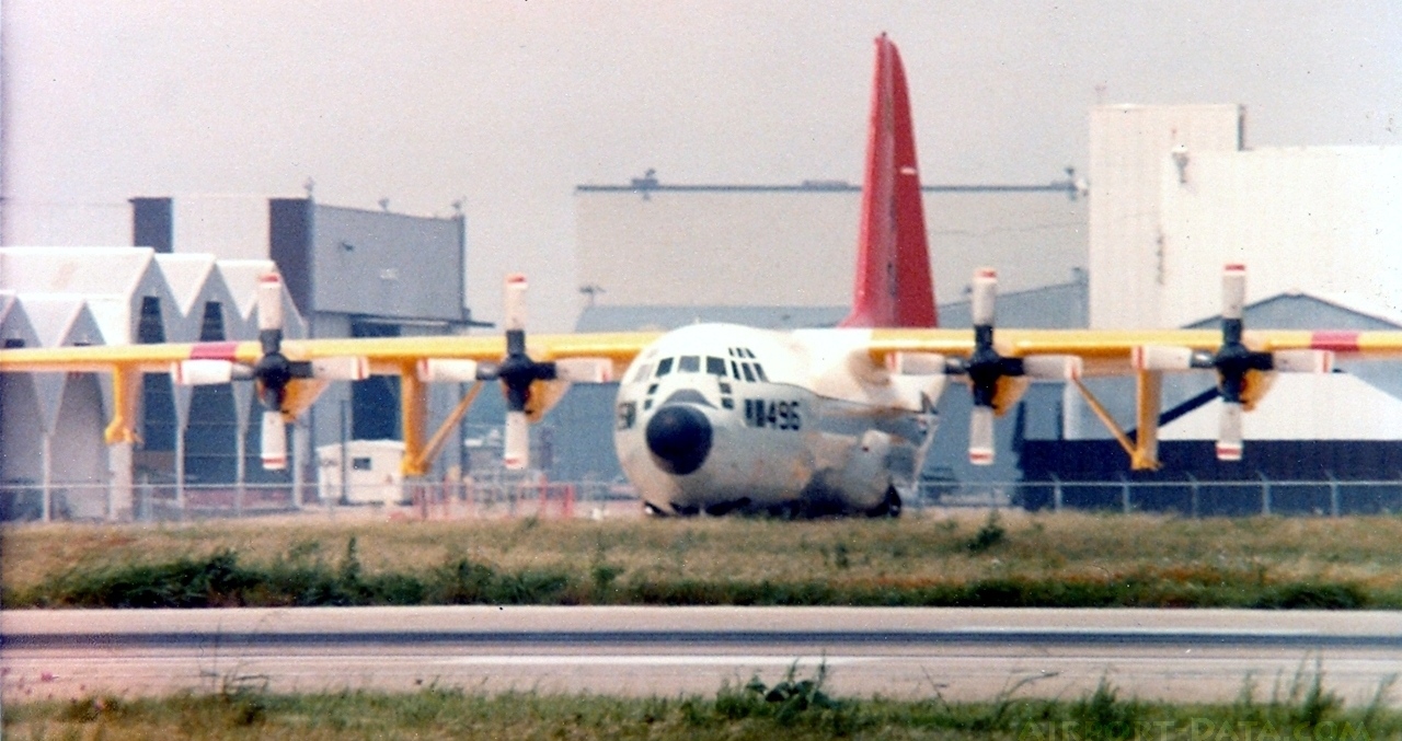
Lou Foote Airport / Highway 77 Airport (revised 10/18/18) - Hensley Field / Dallas NAS (revised 12/7/25)
____________________________________________________
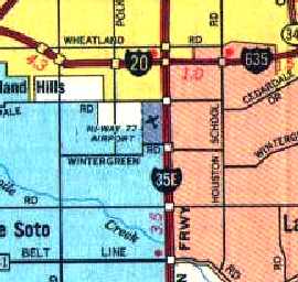
Lou Foote Airport / Highway 77 Airport, Dallas, TX
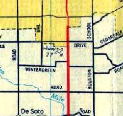
32.626, -96.828 (South of Downtown Dallas, TX)
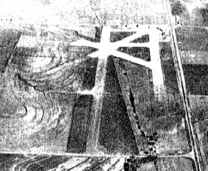
Lou Foote Airport, as depicted on on the February 1943 Dallas Sectional Chart.
This general aviation airport was location on the southern edge of the Dallas city limits.
Foote Airport was apparently built at some point between 1942-43,
as it was not depicted on the September 1942 Dallas Sectional Chart (courtesy of Chris Kennedy).
The earliest depiction which has been located of Lou Foote Airport was on on the February 1943 Dallas Sectional Chart,
which depicted Foote as a commercial/municipal airport.
The earliest photo which has been located of Foote Airport
was a 10/16/43 aerial view looking north from the 1945 AAF Airfield Directory (courtesy of Scott Murdock).
It depicted the field as having 5 runways.
According to Kary McMillen, the field was built by Lou Foote, who taught students at the field during the 1940s.
"I imagine he kept his ownership of the field into the late forties, but was busy training pilots in a number of locations during the war."
Lonnie Wiggins reported, “Lou Foote Airfield... During WWII, it was a airfield used for CAA-WTS pilot instruction.
My father, Harvey Wiggins had a contract with Foote as an instructor.”
The April 1944 US Army/Navy Directory of Airfields (courtesy of Ken Mercer) described Lou Foote Airport as having a 3,900' unpaved runway.
The 1945 AAF Airfield Directory (courtesy of Scott Murdock) described Lou Foote Airport
as a 247 acre rectangular property having 5 caliche runways, the longest being a 3,450' north/south strip.
The field was said to have four 120' x 80' concrete & tile hangars, and to be owned & operated by private interests.
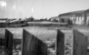
A circa 1940s photo by Bob Johnson of an aircraft & hangar at Lou Foote Airport.
Bob Johnson recalled, “My mother worked for Mr. Foote at the cafe located in the center building between the barracks on the corner.
She also sewed material for airplane owners that covered airplanes.
The cafe & part of the barracks burned probably in the late 1940s.
Lou Foote took my mother up in airplane; he did some crazy things & made her very sick; he was interesting person.”
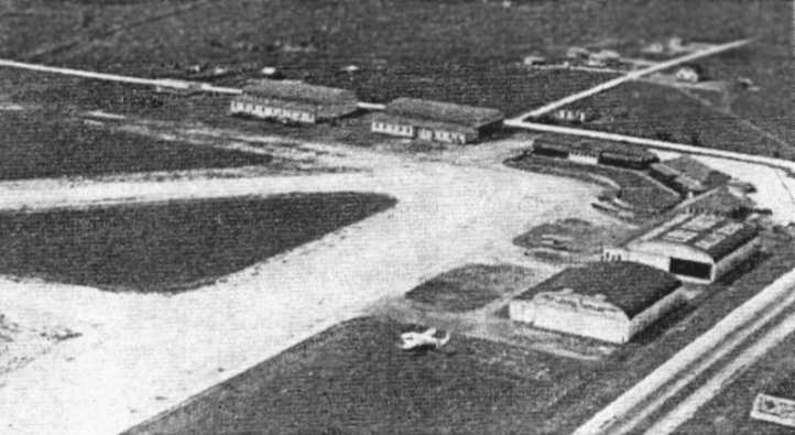
An aerial view looking northwest at Lou Foote Airport from an article entitled "Private Airports"
in the May 1947 issue of the Dallas Chamber of Commerce Magazine (courtesy of Jeff Ferguson).
The photo showed the airport having 4 hangars & some smaller buildings at its northeast corner,
with a single aircraft (a Fairchild AT-21) visible in the foreground.
The article described Highway 77 Airport as being operated by Lou Foote, a "veteran airman".
According to an article entitled “Lou Foote Airport Destroyed by Fire” in the 9/11/47 The Mexia Weekly Herald (courtesy of Micheal McMurtrey),
the airport's Administration building & 2 nearby structures were destroyed in a fire.
It also reported that the airport recently had been placed in receivership & was scheduled for a bankruptcy sale.
By 1947, the field became known as the Highway 77 Airport, named after Highway 77 (later to become Interstate 35),
which ran directly along the eastern edge of the airport property.
The January 1948 Dallas Local Aeronautical Chart depicted Foote Airport as having a 3,500' unpaved runway.
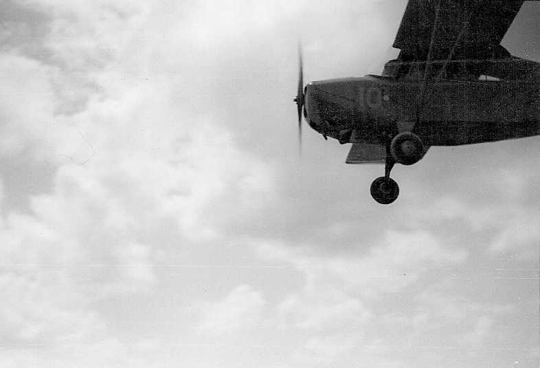
A circa 1951 photo of Howard Kidwell landing an Aeronca at Highway 77 Airport.
Howard Kidwell recalled, "I learned to fly at the Highway 77 Airport in 1951. I soloed in a Piper Cub & then worked then cleaning airplanes for flying time.
I flew Aeronca Champions then, in the 1951-53 timeframe. A B-24 was put in flying condition & they flew it out of there!
I went on to flying fighters for the USAF & am now doing some Citation Flying. All due to my career beginning at Highway 77 Airport!"
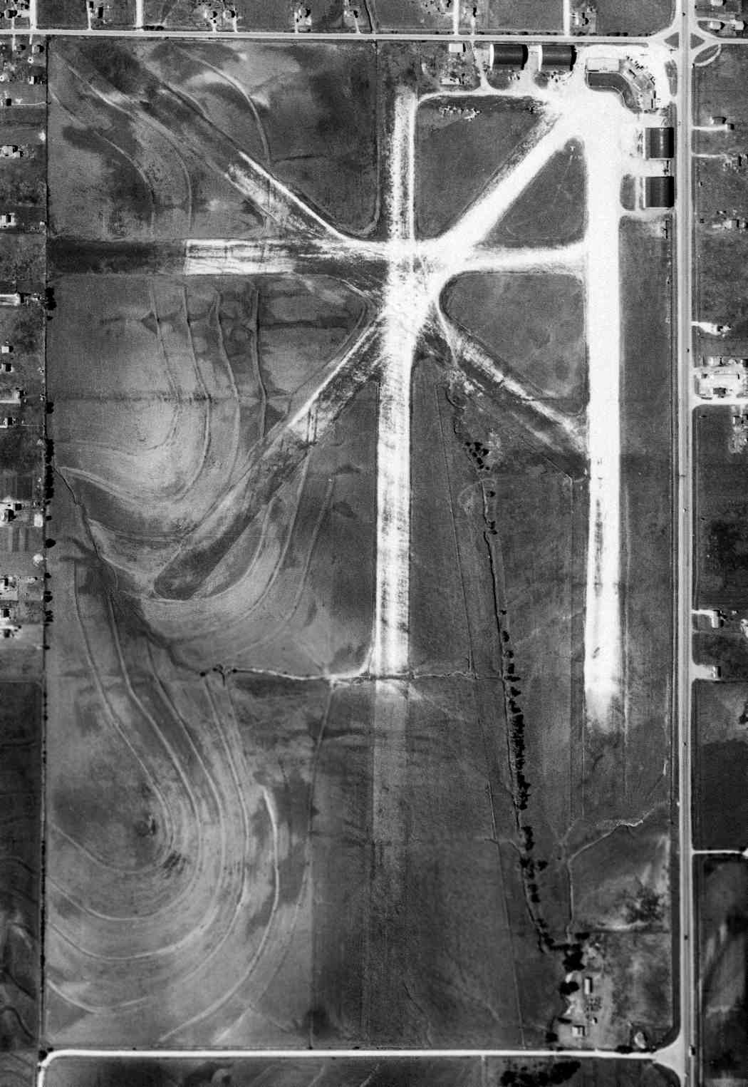
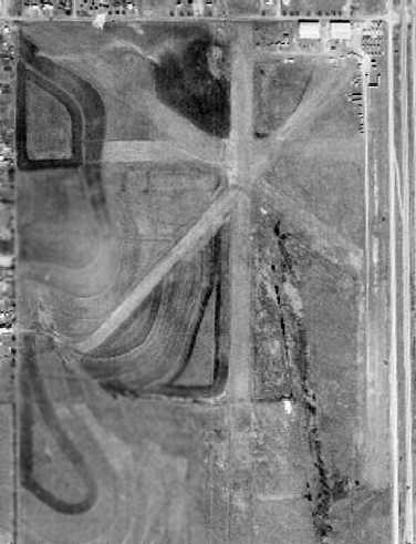
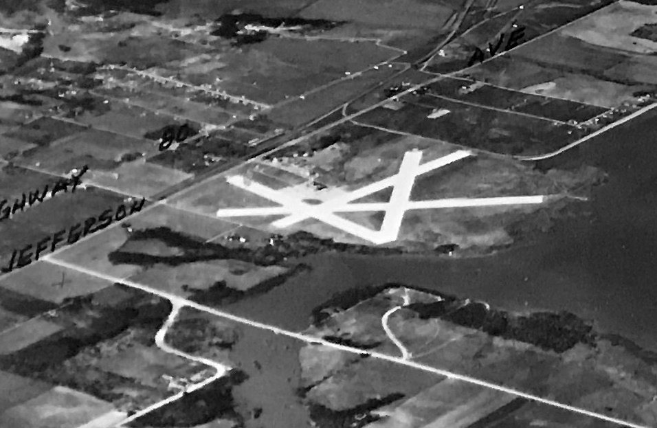
A 4/25/52 USGS aerial view of Highway 77 Airport depicted the field as having a total of 5 unpaved runways.
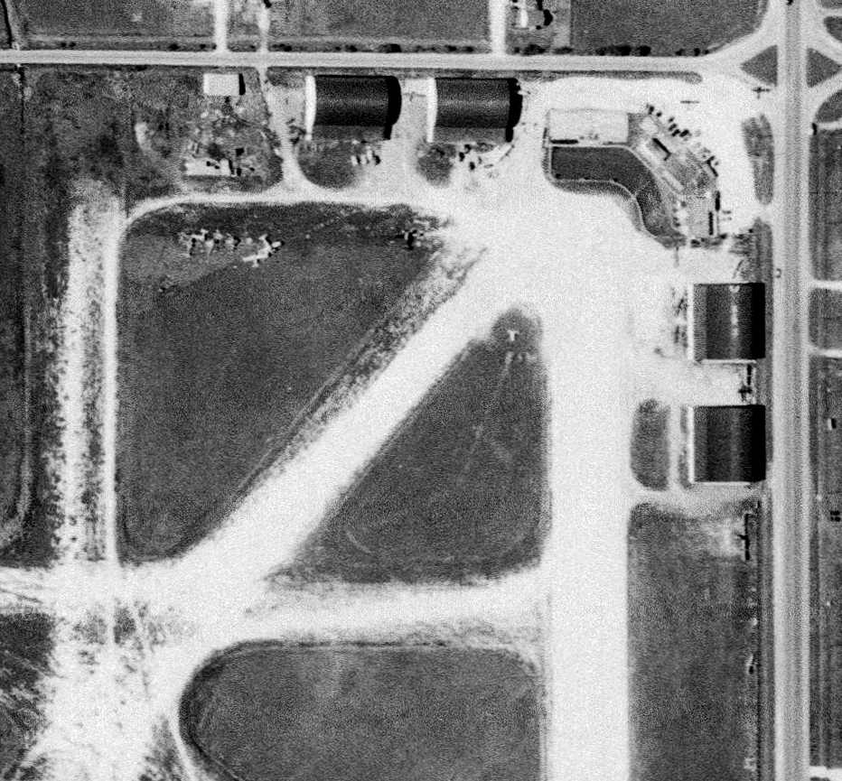
A closeup from the 1952 aerial view depicted the 4 hangars at the northeast corner of the field, and at least 3 aircraft,
along with what appeared to be pieces of several other aircraft on the west side.
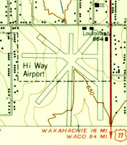
The earliest topo map depiction which has been located of Highway 77 Airport was on the 1958 USGS topo map.
It depicted “Hi Way Airport” as having 5 paved runways, and 5 buildings & a survey marker labeled “Loufoote” at the northeast corner.
Highway 77 Airport, as depicted on a 1960 Humble Oil DFW road map.
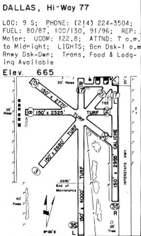
The 1962 AOPA Airport Directory described Highway 77 Airport as having a total of 5 "turf & caliche" runways,
with the longest being the 4,000' Runway 2/20.
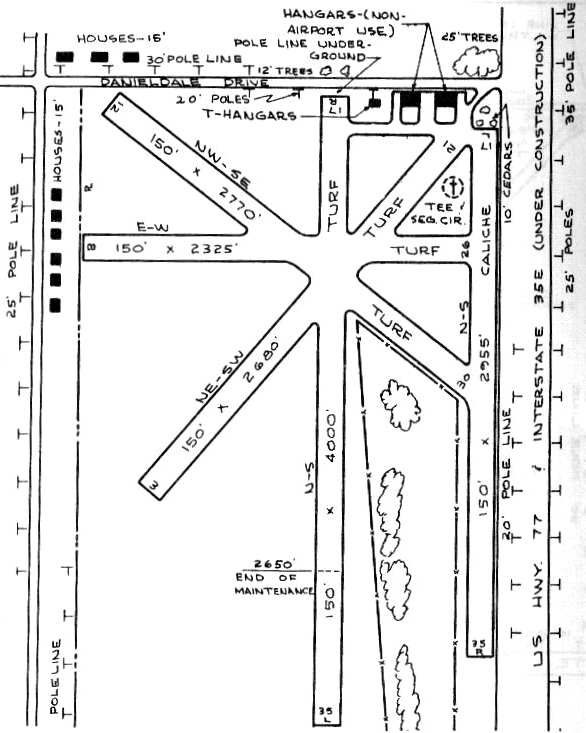
The 1963 TX Airport Directory (courtesy of Steve Cruse) depicted the Highway 77 Airport as having a total of 5 turf & caliche runways,
with the longest being the 4,000' turf Runway 17R/35L.
“Interstate 35E under construction” had eaten away a chunk of the eastern portion of the airport, including the 2 hangars along the eastern side of the field.
A ramp at the northeast corner had 3 hangars (although 2 of the hangars were labeled as having "non-airport use").
The operators were listed as Gabby Hall Aircraft & Modern Aero Sales Company. The airport manager was listed as Orval Kirkwood.
Richard Warner recalled, “I flew out of Highway 77 Airport from 1966-70.
In 1968 (when I was 22), I bought a Cessna 140 there and, a few years later sold it at the same place.
Paul Camp & his wife ran the airport at that time & they called it, at least informally, 'Campaul'.
Paul later moved to Lancaster - maybe that's when Highway 77 Airport closed.
I have very fond memories of Highway 77 Airport. The airport had no runway lights and my Cessna 140 had no landing lights.
So, night landings involved flying south on the west side if I-35, coming over the brightly lighted Gulf billboard at 400',
heading for that long black space on the ground just southwest of the street light at Danieldale & I-35,
going over the airport parking lot at 100' (watch the power lines on Danieldale!)
and touching down on whatever blackness that was just south of the east-west hedge separating the parking lot from the north end of Runway 18L.
Night takeoffs were similar except that I always drove my Volkswagen the length of Runway 18L before takeoff
just to check for teenage parkers or other 'wildlife' - never found any.
During 4 years flying my Cessna 140 plus Piper Cubs, Aero Commanders twins, Commander Larks & Darters,
Luscombes, Mooneys, Cherokee 140s & 180s, and the process of earning my Commercial Pilot rating flying my Cessna 140,
I'll bet I made hundreds of takeoffs & landings at Highway 77 Airport - a great time in my life. There were 5 runways & I used them all.”
Vic Moreland recalled, “I got my license at the 77 Airport in 1967...Paul Camp owned the facility there.”
The 1968 USGS topo map depicted “Hi Way Airport” in an unchanged manner.
Jerry Brown recalled, “My Civil Air Patrol squadron based its aircraft at Highway 77 Airport.
My multi-engine check ride was done by Paul Foster in a 150hp Piper Apache off of Hi-Way 77.”
The 1969 DFW Sectional Chart (courtesy of Ron Myres) depicted the Highway 77 Airport as having a 4,800' unpaved runway.
Russ Riley recalled, “ I called it the 'Riley Airport' because it had that name written across one of the hangars back in the late 1960s & 1970s”
The 1970 TX Airport Directory (courtesy of Ray Brindle) depicted the Highway 77 Airport in basically an unchanged configuration.
Ray Brindle recalled, "It was the airport that separated the men from the boys.
There was a huge billboard at both ends & the telephone lines running parallel to I-35E were 20 feet to your left on a south final.
If you did a touch & go, you had a large pucker factor because you had to clear the billboard on final,
touch down, clean it up, accelerate & climb over huge billboard on departure.
I didn't know squat about Vx or Vy, but I sure knew how to clear a 50' obstacle in real life.
Not a good place for students on a hot Texas day."
Highway 77 Airport was evidently closed at some point between 1970-71,
as it was no longer depicted on the July 1971 Dallas Sectional Chart (courtesy of Ron Plante).
Ben Hendricks recalled, “Lou Foote Airport... my parents bought a travel trailer at this location in the early 1970s.
I remember the hanger that said Riley’s... I believe that was the name of the trailer dealership.”
In a 1972 aerial view, Runway 17L/35R no longer appeared to be in use.
The airport appeared to be on its last legs, with only 2 aircraft visible on the field, and construction equipment clustered around the 2 remaining hangars.
It was labeled “Hi Way Airport (Abandoned)” on the 1974 USGS topo map, but was otherwise depicted in an unchanged configuration,
Highway 77 Airport appeared abandoned in a 1979 aerial photo, with no aircraft visible on the field.
The 2 hangars remained standing, but the runways were noticeably deteriorated.
Of the airport's closure, Ray Brindle noted "It was one of those deals that closed the airport but the industrial park never happened."
Highway 77 Airport was still depicted on a 1979 AAA DFW road map, but that does not necessarily indicate that it was still open at that point.
According to RC Roark, "It seems like in the late 1970s or 1980s, after the airport closed down, the hangar was used by some kind of pallet company.
I don't recall any name, just a gigantic stack of wooden pallets next to the hangar, higher, longer & wider than the hangar itself."
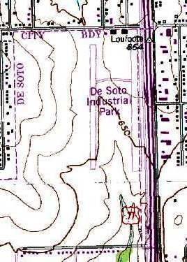
The 1981 USGS topo map labeled the Highway 77 Airport site as "De Soto Industrial Park" (which never happened, making the airport's closure pointless).
The outline of 2 north/south runways was still depicted, underneath the "Industrial Park" label, ironically.
Note that the topo map still depicted a surveying marker labeled "Loufoote" at the northeast corner of the former airfield property,
named after the founder of the former airport.
Dennis Merrell recalled, “Lew Foote Field... I operated an Ultralight [aircraft] training school at this strip [in the] early- to mid-1980s.
I remember an old timer stopping in & saying that the ghost of Lew Foote would be proud of me.
I had no idea to what he was referring to. Thanks for clearing this up.
Airsports Aviation was the last operator of this old hangar & grass strip.”
A 1989 aerial view showed that the last 2 hangars had been removed at some point between 1979-89,
and a road had been cut through the center of the former airfield.
The outline of the former runways were no longer apparent.
Highway 77 Airport was no longer depicted on the 1998 DFW Terminal Aeronautical Chart (courtesy of Ron Plante).
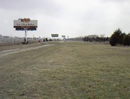
A 2003 photo by Ray Brindle, looking south down along the former Runway 18.
The billboards on the side were not there when it was open, just one at both ends.
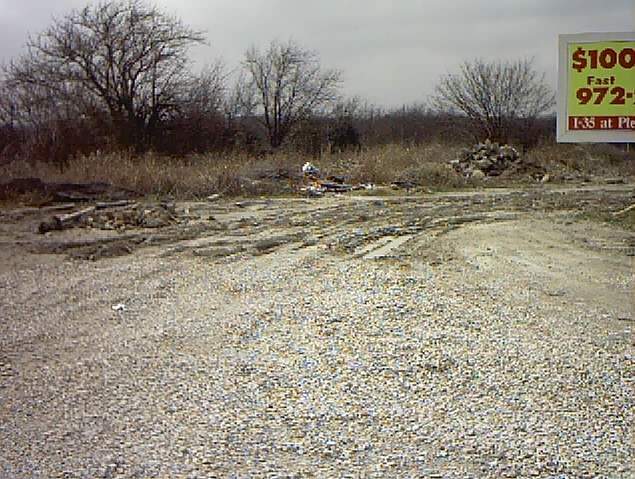
A 2003 photo by Ray Brindle of the area where hangar once stood, now mostly a trash dump.
Ray Brindle observed, "There are remnants of the main hangar still there at the corner of Danieldale & I-35E service road."

A 2003 photo by Ray Brindle, looking south down the end of the former Runway 18.
The runway is now cut by a street but the billboard at the end of the former Runway 18 is still being used.
Ray Brindle observed, "The 2 billboards that used to terrify student pilots are still at both ends of the old runways.”
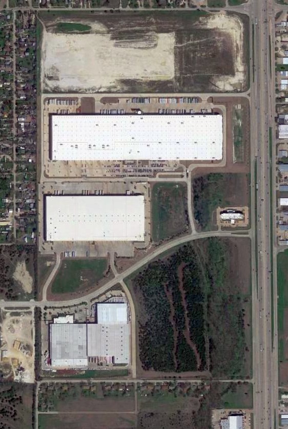
A 2015 aerial view shows the site of Highway 77 Airport has been covered by several large buildings.
The site of Highway 77 Airport is located southwest of the intersection of Interstate 35 & Danieldale Road.
____________________________________________________
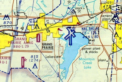
Hensley Field / Dallas Naval Air Station (7TX2), Dallas TX
32.74, -96.969 (Southeast of DFW Airport, TX)

A letter with a postmark commemorating the “Visit of 675 First Air Corps, May 12-14, Hensley Field, Dallas TX 1931” (courtesy of Marshall Morgan).
According to the text of a TX Historical Commission historic sign, “The city of Dallas purchased land at this site in 1928 & leased it to the U.S. Army for a training airfield,
as Love Field had become too busy to provide safe facilities for training.
The field was named for Major William Hensley, an air officer for the 8th Corps Army Area who helped select the base site before his death.
Army air operations were moved here from Love Field, and Hensley Field became the center of all area Army air training operations & a key repair & refueling point in the southwest.”
A letter with a postmark commemorated the “Visit of 675 First Air Corps, May 12-14, Hensley Field, Dallas TX 1931” (courtesy of Marshall Morgan).
The earliest depiction which has been located of Hensley Field was on the 1932 Dallas Sectional Chart (courtesy of Scott O'Donnell).
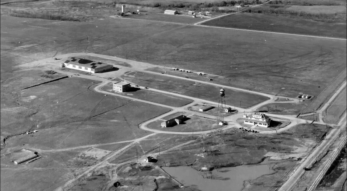
The earliest photo which has been located of Hensley Field was a circa 1930s aerial view looking southwest (courtesy of Nathan Clay).
It depicted 4 biplanes parked on the east side of a north/south grass runway, with a single hangar & several smaller buildings on the east side.
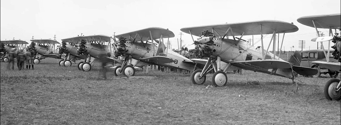
A circa 1930s photo of 7 Boeing F4B-1 fighters of Navy Fighter Squadron VF-5B visiting Hensley Field (courtesy of Nathan Clay).
A 7/25/40 aerial view looking northeast depicted Hensley Field as having 4 paved runways, with hangars & ramps on the northeast side,
a considerable expansion in the runway configuration compared to the 1930s photo.
Note that the North American Aircraft plant had yet to be built on the northwest side.
On 9/28/40 the Federal Government's Defense Plant Corporation built a large aircraft manufacturing plant on the northwest corner of Hensley Field
which was operated by the North American Aircraft Corporation, designated their Plant A.
This million square foot plant was built specifically for the production of AT-6 (SNJ) as a Naval Weapons Industrial Reserve Plant.
Plant A's production commenced in March of 1941. North American's Dallas facility employed a total of 39,000 workers at its height.
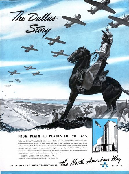
A circa 1941 advertisement for Hensley Field's North American factory, noting its amazing transformation “From plain to planes in 120 days.”
According to Wikipedia, “At the beginning of World War II, the Army extended their lease to 40 years.
In March 1941, the Navy began maintaining operations at the base & shortly afterward established a naval reserve training base on 160 acres adjacent to Hensley Field.”
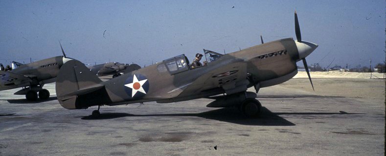
A 1941 photo of 2 Curtiss P-40E Warhawks at Hensley Field.
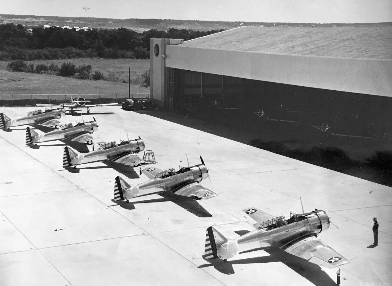
A circa 1941-44 photo of a row of factory-new AT-6 & SNJ Texans outside Hensley Field's North American Plant.
Adjacent to the main Plant building was a storage hangar for AT-6s awaiting delivery, with a 300' wide door.
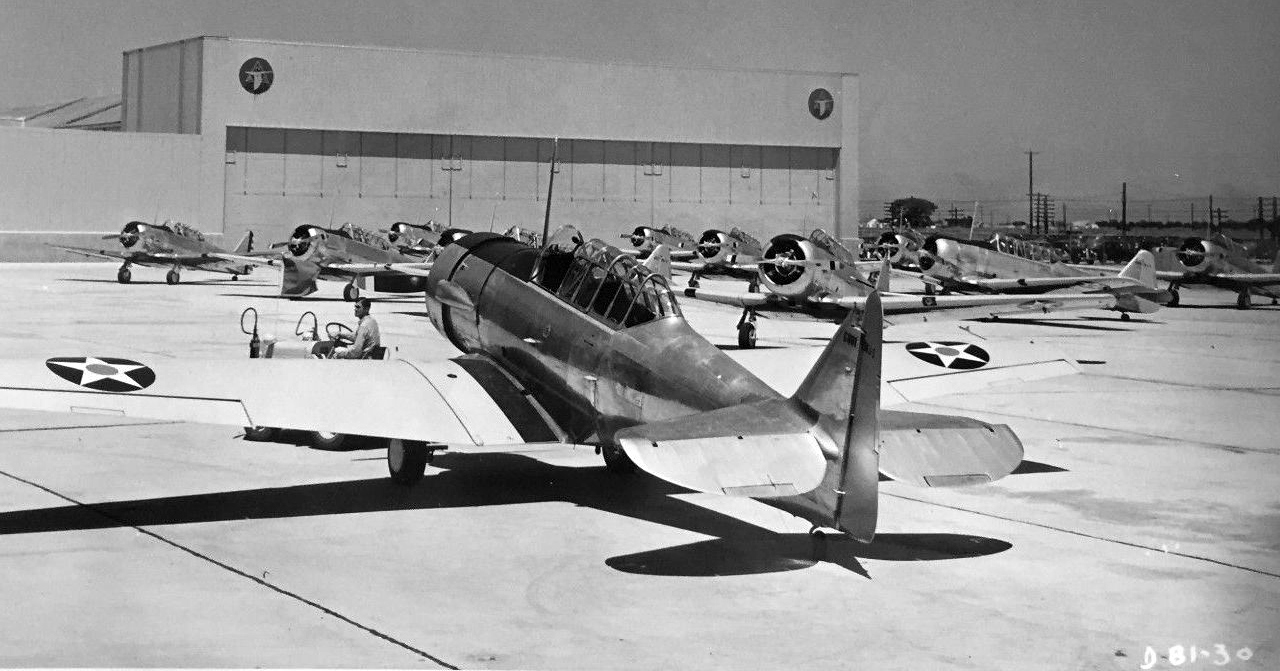
A circa 1941-44 photo of a brand-new Navy SNJ-3 Texan outside Hensley Field's North American Plant, in front of dozens of AT-6s & SNJs.
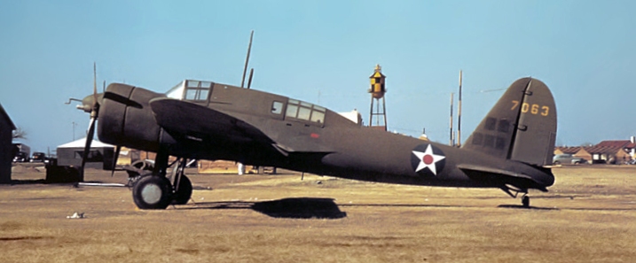
A March 1942 photo of a rare Curtis A-18 Shrike at Hensley Field (courtesy of Nathan Clay).
"Hensley" was depicted as a military airfield on the February & September 1942 Dallas Sectional Charts (courtesy of Chris Kennedy).
A 1942 aerial view looking west (National Archives photo) depicted Hensley Field as having 4 paved runways,
with hangars & ramps on the northeast & southeast sides, and the North American Aircraft plant on the northwest side.
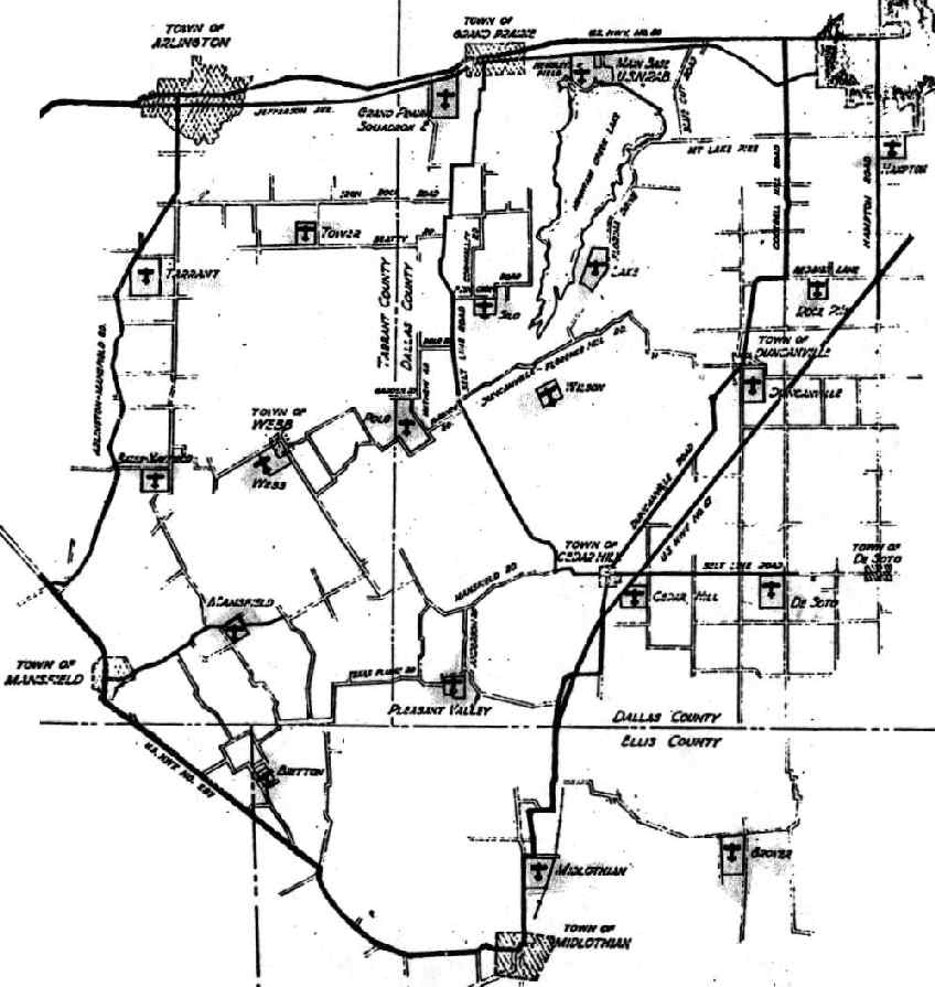
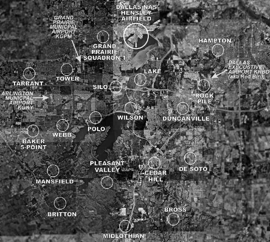
"Location of Outlying Primary Landing Fields, US Naval Reserve Aviation Base, Dallas, TX", 1942 (courtesy of John Voss).
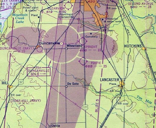
To support training at Dallas NAS, by 1942 the field had a total of 20 Outlying Landing Fields.
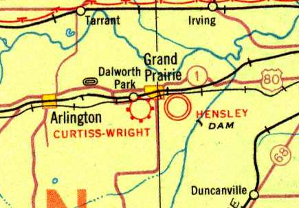
Five of these fields were paved, including Five-Point NOLF (labeled "Baker-Mansfield" on the map above), Mansfield NOLF,
Arlington NOLF (labeled "Tarrant" on the map above), and Grand Prairie NOLF.
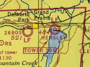
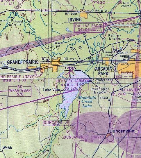
The other fields were: Tower (later reused as the new Grand Prairie Municipal Airport), Webb, Britton, Polo, Silo, Wilson,
Lake, Midlothian, Pleasant Valley, Cedar Hill, Grover, De Soto, Duncanville, Rock Pile, and Hampton.
The Naval facility was renamed Dallas Naval Air Station in 1943.
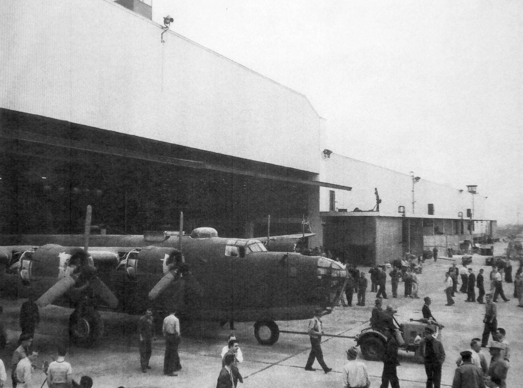
A 3/16/43 photo of the rollout of Consolidated B-24G-NT (serial # 42-7804), the first Liberator to be built at the North American Aircraft Hensley Field factory (courtesy of Nathan Clay).
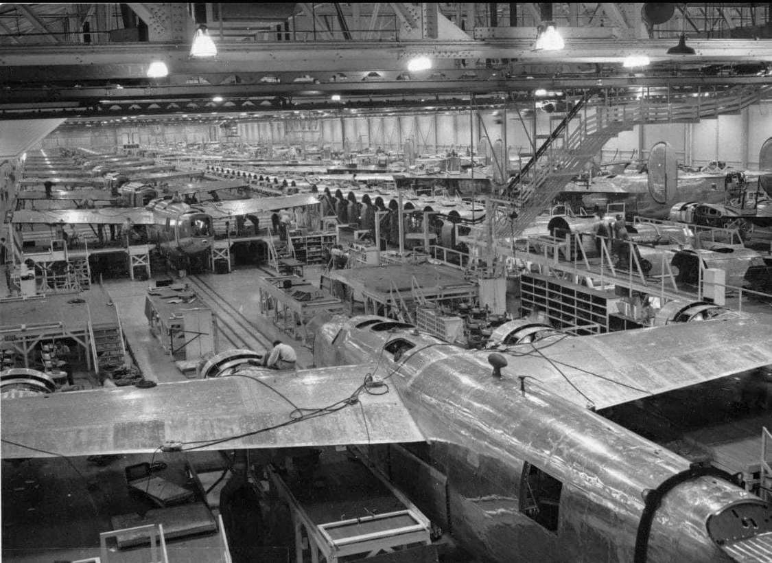
A circa 1943-45 photo of Consolidated B-24 Liberator bombers on the North American Aircraft Hensley Field assembly line (courtesy of Nathan Clay).
A circa 1943 aerial view looking west from the 1945 AAF Airfield Directory (courtesy of Scott Murdock)
depicted Hensley Field as having 3 paved runways & parallel taxiways.
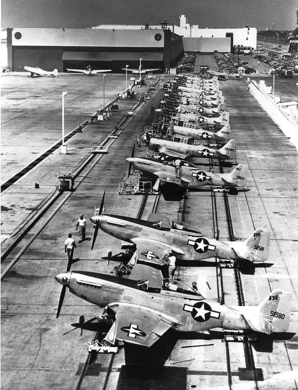
A circa 1943-45 photo of a row of North American P-51D Mustangs & T-6 Texans in front of the North American Aircraft Hensley Field factory (courtesy of Nathan Clay).
Hensley Field, as depicted on the August 1944 Dallas Sectional Chart (courtesy of David Brooks).
The Army Air Forces used their portion of Hensley Field for the training of ferry pilots during WW2,
and later used the field to store surplus aircraft following the end of the war.
North American's Plant A produced a total of 12,967 AT-6s, 4,552 P-51s, and 299 F-6s during WW2.
The 1945 AAF Airfield Directory (courtesy of Scott Murdock) described Hensley Field
as a 638 acre irregularly-shaped property having 3 concrete 5,200' runways.
The field was said to have 3 metal hangars, the largest measuring 200' x 130'.
After the end of the Second World War, the former AAF facilities at the northeast corner
were eventually taken over by the Texas Air National Guard.
The primary runway was expanded to its ultimate size of 8,000' in 1952
to support the arrival of the field's first jet aircraft, the FH-1 Phantom.
In 1945, the North American Aviation plant adjacent to the field was deactivated.
In 1945, several North American employees left the company
to form their own venture, the Texas Engineering & Manufacturing Company (TEMCO).
This new firm used the former North American Aviation plant,
and specialized in airframe-oriented efforts such as subcontract manufacturing of aircraft assemblies,
general aircraft overhaul, aircraft conversion & other special modifications.
TEMCO built Globe Swifts under a license from nearby Globe Aircraft Company in Fort Worth,
as well as other small civil & military aircraft.
Production of the Swift ramped up very quickly, but the Globe Aircraft Company soon dissolved after running into business difficulties.
TEMCO obtained rights to the Swift as payment for money owned them by Globe,
and all parts & production tooling for the Swift were transferred from Globe to the TEMCO Grand Prairie plant.
For more information on TEMCO, see: http://www.napanet.net/~arbeau/swift/conder.htm
TEMCO enjoyed a rapid expansion with its military contracts,
involving production of 400 C-82 subassemblies & 200 F-24 subassemblies for Fairchild Aircraft Company.
After the firm acquired additional facilities in Greenville, the Grand Prairie plant focused primarily on Navy programs.
The next occupant of the Grand Prairie aircraft plant was Vought.
In 1946, the government attempted to interest prime aircraft contractors located in congested pre-war plants
to relocate to the more modern facilities constructed during the war.
The Chance Vought Aircraft plant at Stratford was one of the first plants the government contacted.

An undated aerial view looking northwest at Dallas NAS from the 9/47 Naval Aviation News,
showing the field still in its WW2 runway configuration.
The January 1948 Dallas Local Aeronautical Chart depicted “Hensley (Army)” as having 3 paved runways, with the longest being 5,200'.
In 1948, the Navy announced that Chance Vought would move its entire operation to the Naval Weapons Industrial Reserve Plant in Dallas, Texas.
The move was completed by mid 1949 – the largest industrial move of its kind up to that time.
Metro Goldwyn-Mayer announced a film would be made of the historic move.
The movie, to be entitled "Yankee in Texas" with Spencer Tracy,
never came off as political pressure led by Connecticut’s governor, Chester Bowles,
sought to stop the unfavorable publicity he felt this exposure would give their state.
Twenty-seven million pounds of equipment & 1,300 key personnel & their families were moved the 1,700 miles during 1948-49.

A circa 1949-50s photo of F4U Corsair fighters on the Vought Hensley Field assembly line (courtesy of Nathan Clay).
In the 1950s, the Vought plant was expanded, and additional facilities were constructed, including several wind tunnels.
Hensley's Runway 17/35 was evidently lengthened to 8,000' at this time to support jet operations.
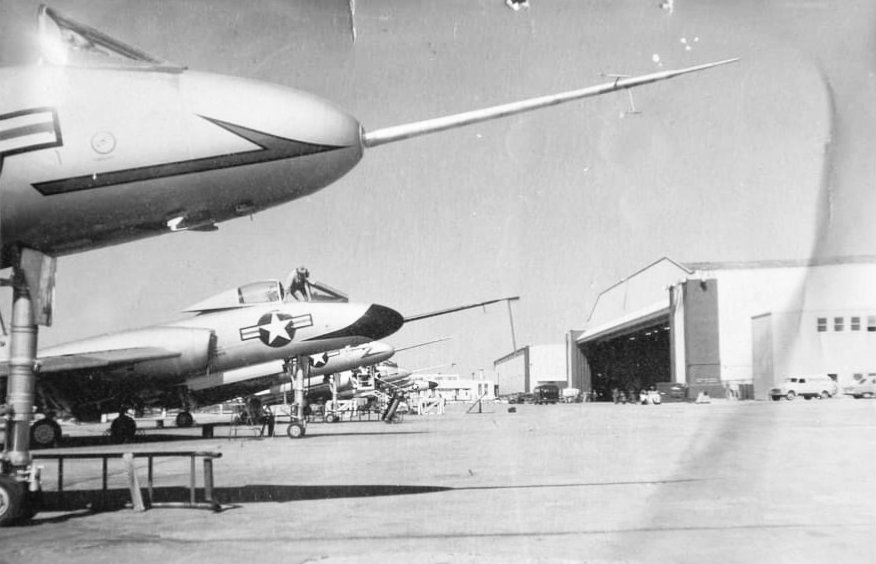
A 3/1/50 photo (courtesy of Nathan Clay) of Vought F4U-5N Corsairs & a F7U Cutlass at Hensley Field.
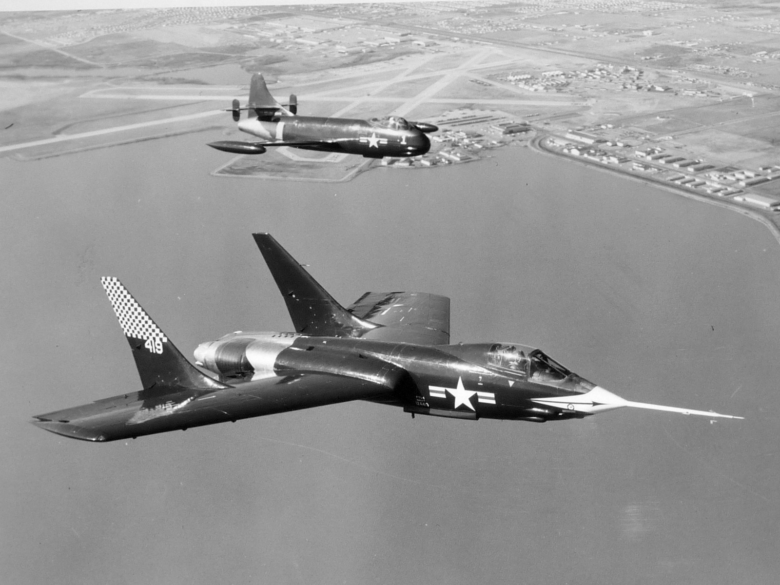
A circa 1950s aerial view (courtesy of Nathan Clay) looking northwest at 2 early Vought jets (an F6U Pirate & XF7U-1 Cutlass) overflying their home at at Hensley Field.
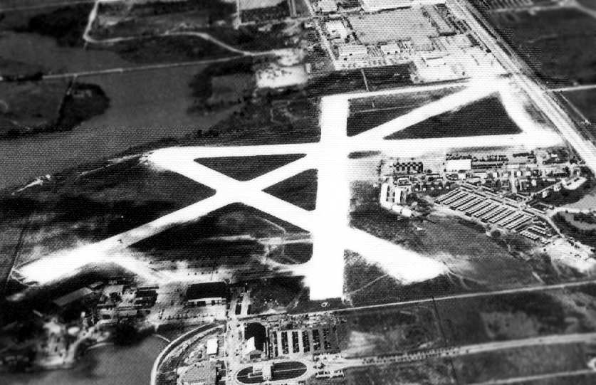
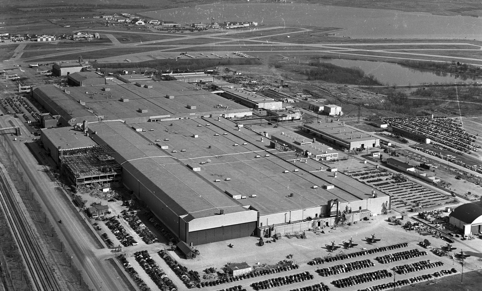
A 4/1/52 USGS aerial view of the massive Hensley Field facilities.
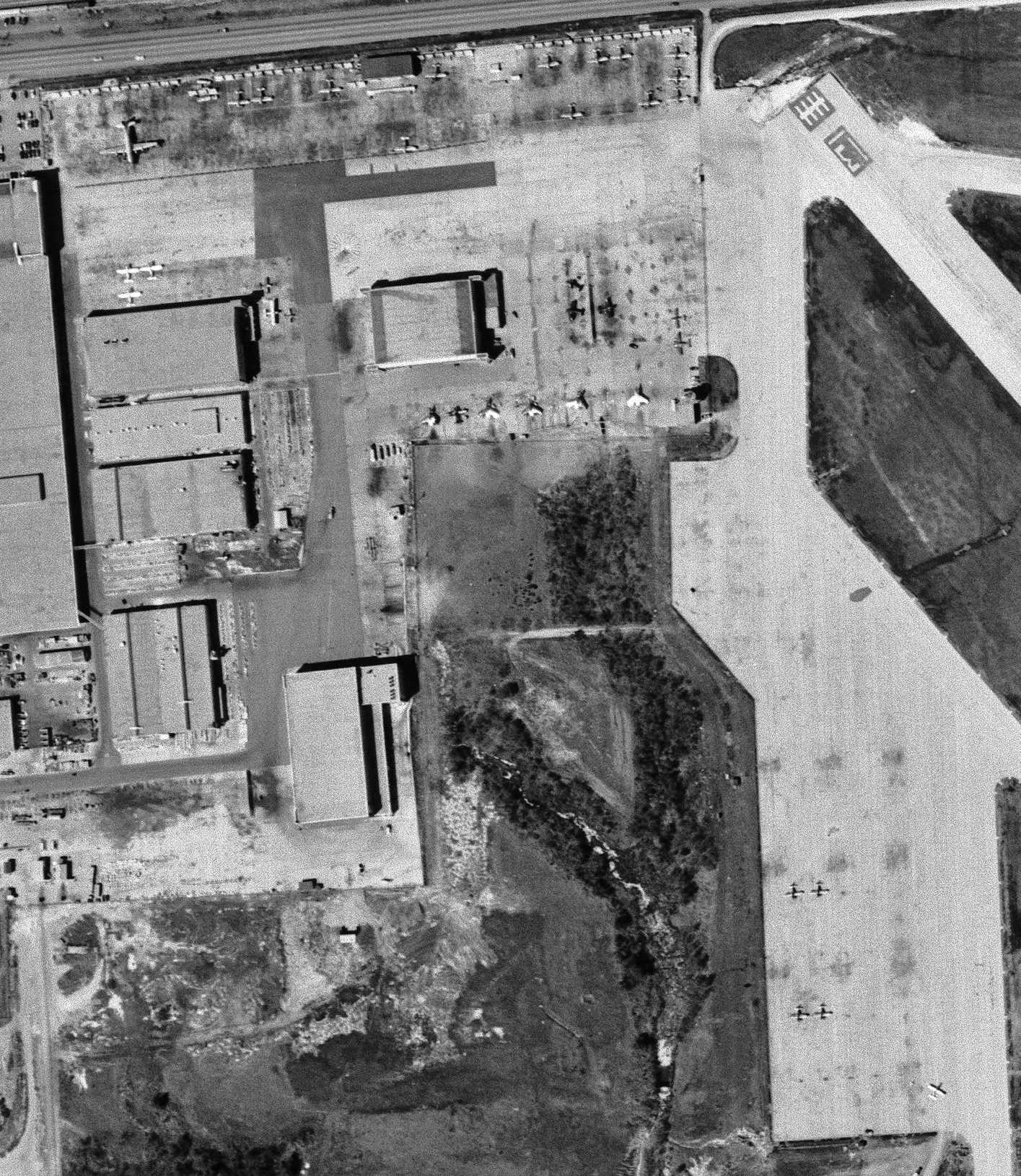
A closeup from the 4/1/52 USGS aerial view of Hensley Field's Vought ramp, showing newly-built F7U Cutlasses & other aircraft.
A closeup from the 4/1/52 USGS aerial view of Hensley Field's east ramps, showing a wide variety of military aircraft.
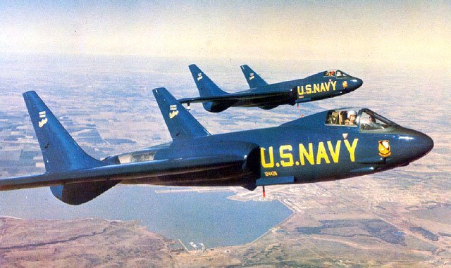
A 1952-53 aerial view (courtesy of Nathan Clay) looking northwest at 2 Vought F7U-1 Cutlasses of the Blue Angels overflying their home at at Hensley Field.
These 2 Cutlasses had a very brief service with the Blue Angels: being delivered in 1952, and withdrawn the next year, being sent to NAS Memphis to become ground maintenance instructional airframes.
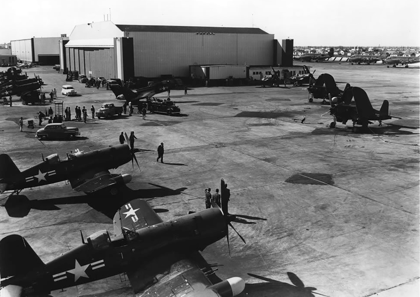
A 5/5/53 photo of Vought F7U-1 Cutlass fighters on the Vought Hensley Field ramp (courtesy of Nathan Clay).
Aircraft manufactured at Dallas by Vought in the 1950s included the F4U Corsair, the F7U Cutlass, the Regulus I missile, and the F8U Crusader.
From a post-WW2 low of 3,600, employment increased to 17,000 by 1957.
A total of 1,263 F-8 Crusaders were eventually built in Dallas.
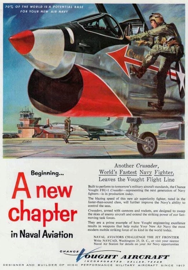
A circa 1950s Vought Aircraft F8U Crusader poster (courtesy of Nathan Clay).
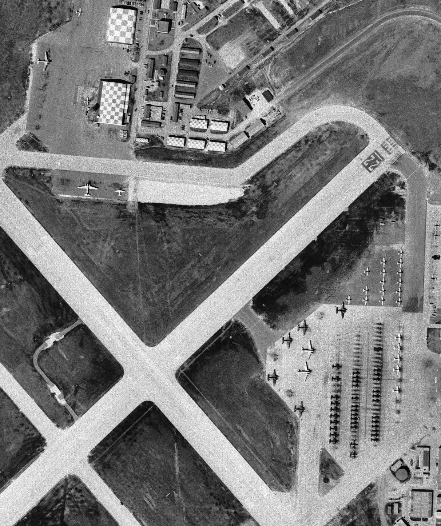
A 1958 aerial view showed a large number of F8U Crusaders awaiting delivery on the Vought ramp,
as well as large number of aircraft (Fairchild R4Q transports & fighter aircraft) on Hensley's northwest ramp.
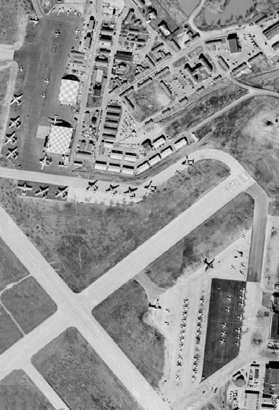
A 1958 aerial view showed a large number of multi-engine & tactical aircraft on Hensley's east ramp.
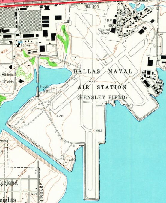
The 1959 USGS topo map depicted “Dallas Naval Air Station (Hensley Field)”
having having 3 paved runways, taxiways, hangars, and factory buildings.
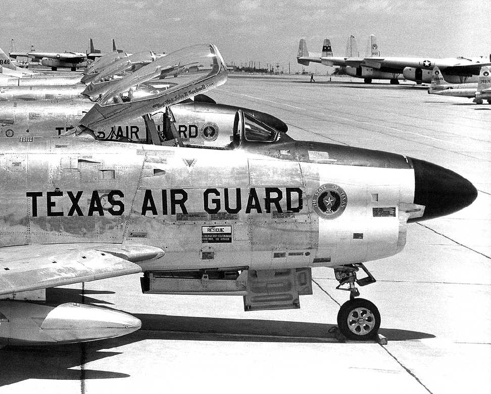
A circa 1950s-60s photo of North American F-86D-41-NA & F-86D-36 Sabre Dogs of the TX Air National Guard's 181st Air Defense Squadron at Hensley,
with several C-119s & T-33s also visible in the background.
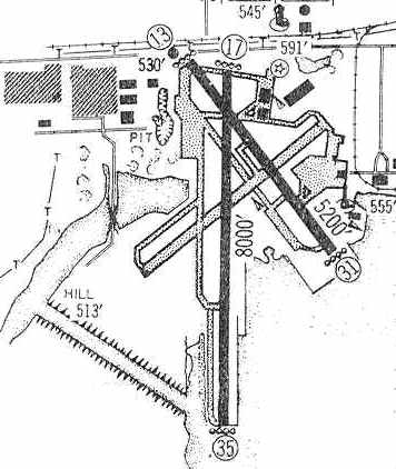
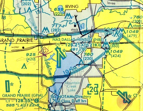
As depicted in the 1960 Jeppesen Airway Manual (courtesy of Chris Kennedy),
the airfield at NAS Dallas consisted of 2 paved runways: an 8,000' Runway 17/35 & a 5,200' Runway 13/31
(the former northeast/southwest runway had evidently been closed).
A large number of taxiways, hangars, and factory buildings were also depicted.

A July 1960 photo by Darrell Crosby of 2 North American F-86L Sabres in air defense alert shelters at NAS Dallas.
Darrell recalled, “I was there for the National Model Airplane Championships.
During the day the base would be closed between 8AM-5PM & if anything flew it was these F-86Ls that were fully armed with air-to-air rockets.
The Air Guard commander let me take photos of the F-86Ls but told me to not get near the planes with 3 day-glow strips of tape on the side
for that indicated that they were fully armed for intercept.”
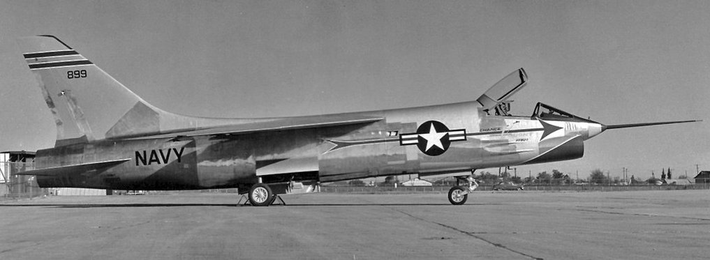
A 1960 photo by Erwin Bulban of a beautiful prototype Vought XF8U-1 Crusader at Hensley Field.
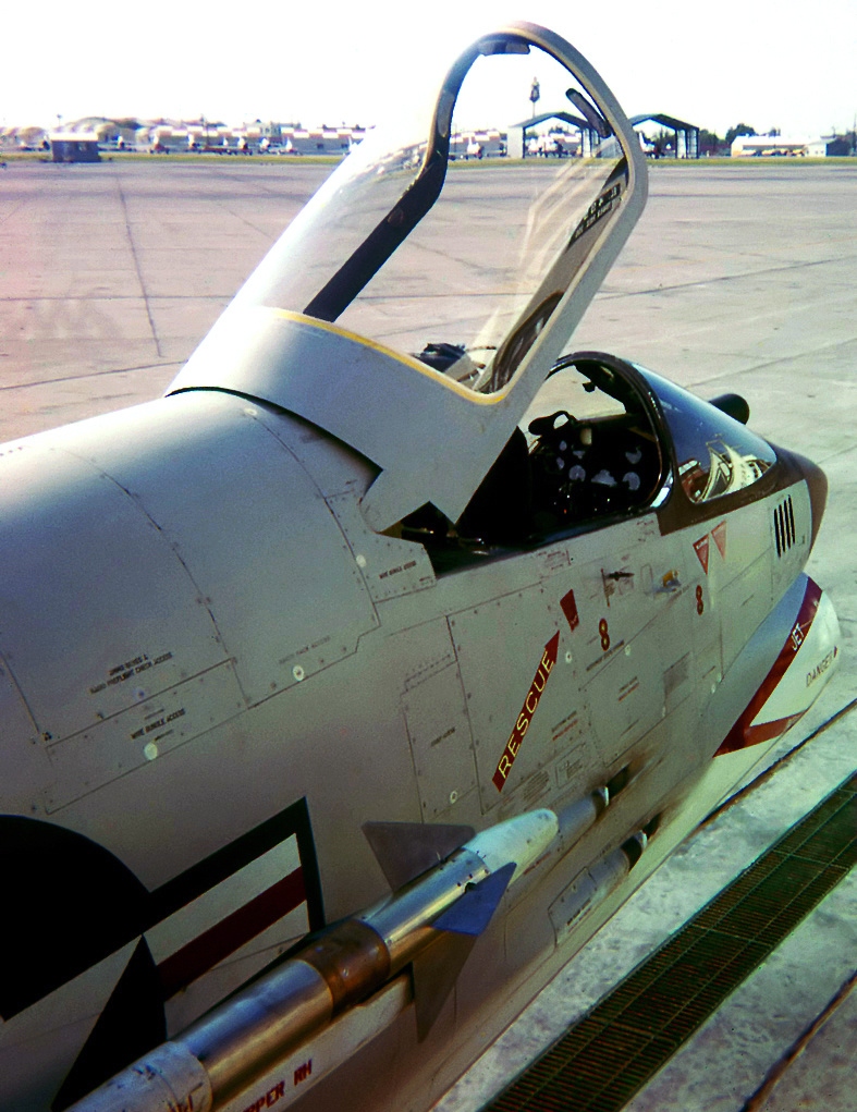
A July 1960 photo by Darrell Crosby of a Vought F8U-2N Crusader at Hensley Field.
During the 1960 National Model Airplane Championships, a Navy seaman had tugged a brand-new Crusader over after a gun test, with gun dust on the plane.
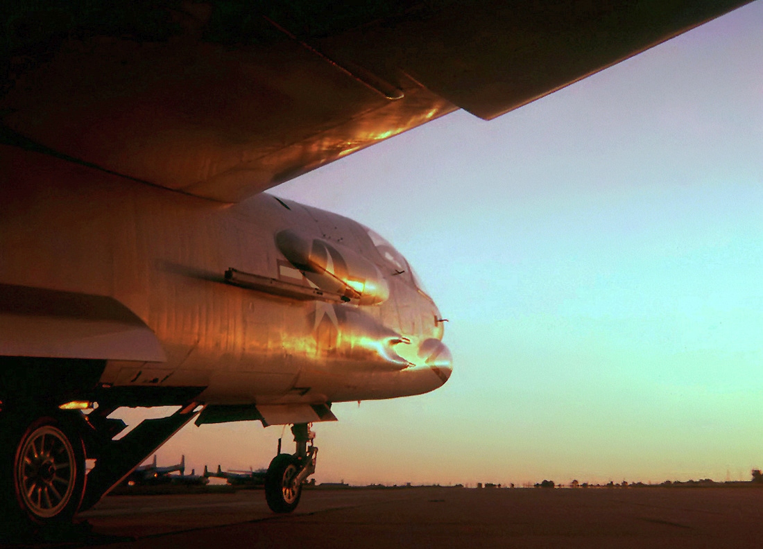
A beautiful sunset July 1960 photo by Darrell Crosby of a Vought F8U-2 Crusader at Hensley Field.
John Price recalled, “Hensley Field / NAS Dallas: I was in the Naval Air Reserve here in the 1960s.
We were flying C-118Bs. The Air National Guard was across the field flying KC-97s.”
In addition to the F-8 Crusader, the Dallas facility produced its cousin, the A-7 Corsair.
The first A-7 flew in 1965, and the type went on to see widespread service with the Navy, Air Force, and foreign militaries.
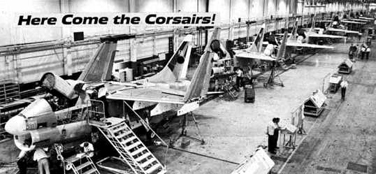
A 1966 photo of A-7s coming down the Vought assembly line.
The July 1971 Dallas Sectional Chart Dallas inset (courtesy of Ron Plante)
depicted NAS Dallas as having 3 paved runways, with the longest being 8,000'.
A 1972 aerial view showed a stark difference in the level of activity noticeable on the northwest ramp (near Vought),
as compared to the 1958 photo.
Only a few aircraft were visible on the entire northwest ramp.
The 1972 photo also showed that a new ramp had been built at some point between 1960-72 on the northeast portion of the base,
effectively ending any use of the former northeast/southwest runway.
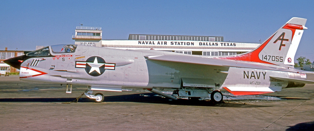
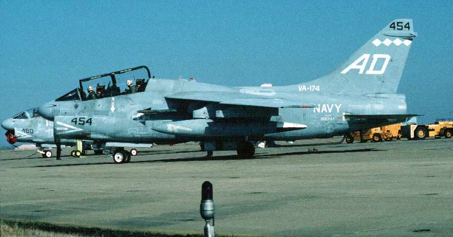
A 10/19/75 photo by R.A. Scholefield of Navy Reserve VF-201 “Red Raiders” Vought F-8H Crusader 147055 C/n 797 in front of an NAS Dallas hangar.
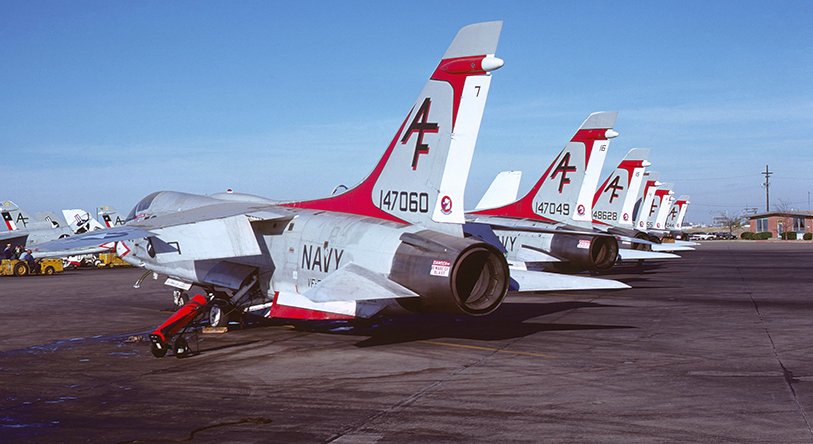
A 12/14/75 photo of a row of pretty VF-201 Vought F-8H Crusaders on the NAS Dallas flight line.
Ted Waldron (the former ANG Facility Manager at Hensley Field) recalled,
"I was on Hensley Field from 1975-93 & saw quite a few changes to the base, especially in the ANG.
During that time we got rid of all the WW2 buildings on the ANG side."
On a 1979 aerial view, not a single aircraft was visible on the entire northwest ramp,
indicating the decrease in the level of activity at the Vought factory.
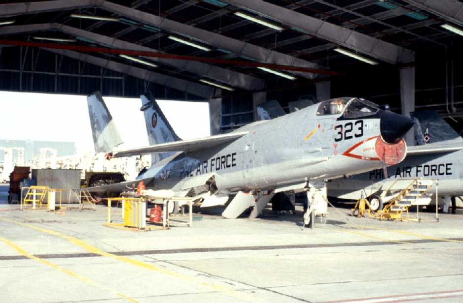
A 3/10/79 photo by David Lednicer of an ex US Navy F-8H Crusader awaiting delivery to the Philippine Air Force inside a Vought hangar at Hensley.
The 1979 aerial photo also showed the new facilities that had been constructed at some point between 1972-79
on the southwest side of the field for TX Army National Guard helicopter operations, including new taxiways, ramps, and hangars.
It also appeared as if Runway 13/31 was no longer active, as aircraft were parked on the southeast end,
effectively leaving the field with only one active runway.
A 1981 photo of a Douglas EF-1B Skyknight at Hensley Field.
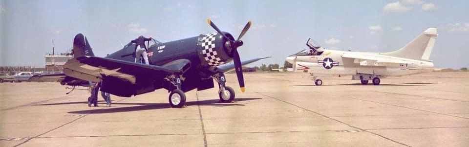
A 1981 photo by Gregory Carroll of an FG-1D Corsair & A-7 Corsair II at Hensley Field (courtesy of Nathan Clay).
The Corsair had completed a 6-year restoration by Vought employees, and was flown by LTV Chairman Paul Thayer.
Connery Carroll recalled, “This photo was taken by my father, Gregory Carroll when he ran the photo lab at Vought.
He said that while he was taking pictures, he saw the A-7 rolling by & waited to get it framed perfectly for this shot.”
A March 1981 photo of a Navy DC-130A Hercules drone carrier aircraft at Vought's facilities on Hensley Field.
A-7 Corsair production ended in 1984, by which point the Dallas facility had produced 1,569 of the attack jet.
The A-7 was the last complete aircraft to be produced in volume at the Dallas facility -
all subsequent Vought Dallas production centered on aircraft structural components subcontracted for other manufacturers.
In the 1980s, Dallas NAS was host to many different squadrons of the Navy & Marine Corps Reserve & Army National Guard.
In 1988 it was announced that LTV (Vought) was a major production subcontractor on the Northtop B-2 Stealth Bomber, designing & producing the intermediate wing section.
LTV also designed the installation of all systems in the intermediate section.
Twenty one ship sets of the intermediate wing section were built & shipped by C-5 Galaxy to Palmdale, CA, for final assembly.
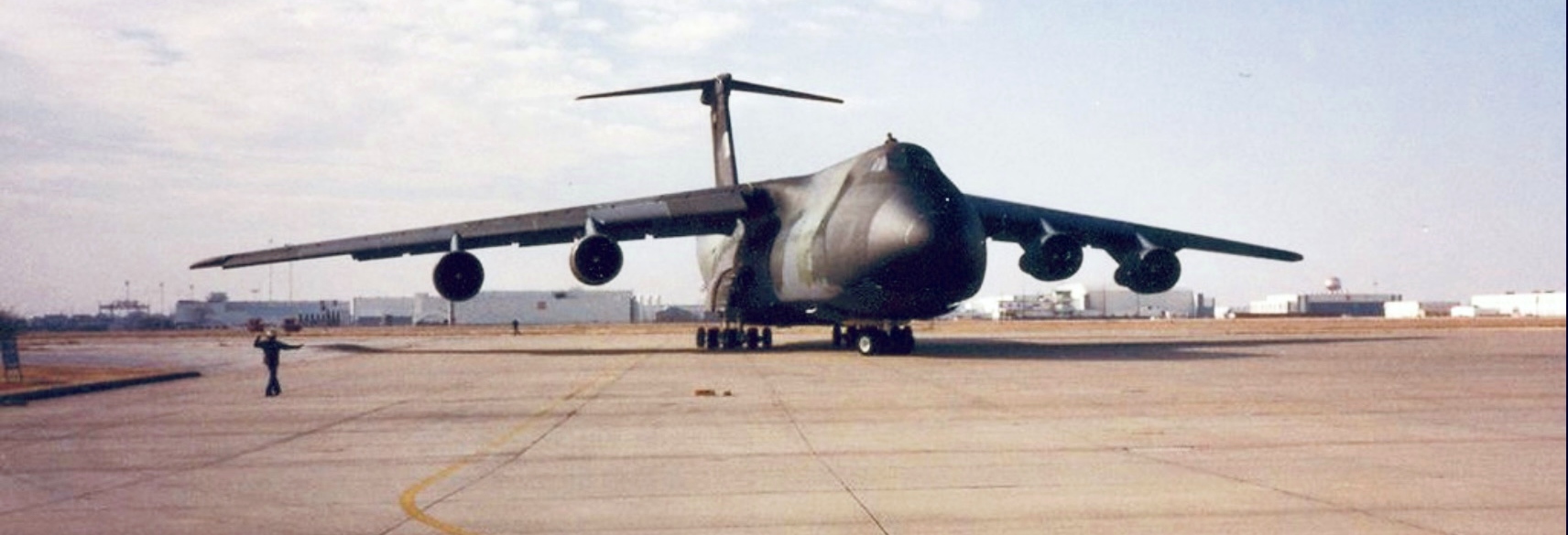
A circa 1980s-90s photo of a Lockheed C-5 Galaxy at Hensley Field, presumably coming to pick up B-2 bomber wing sections built at the LTV plant.
A 2/1/88 DOD photo by Wayne Whited of an Attack Squadron 174 Vought TA-7C Corsair II parked on the NAS Dallas flight line.
The Corsair was built at the Vought facilities on the west side of the field.
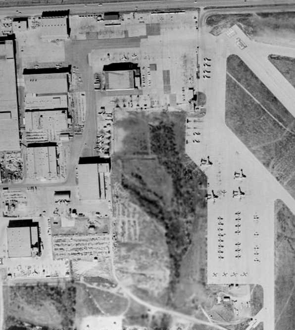
A 1989 aerial view depicted a total of only 16 aircraft & helicopters on all of the expansive east ramps of Hensley.
An 8/6/89 photo By Stephan de Brujin of USMC VMFA-112 McDonnell Douglas F-4S Phantom II 155829 C/n 3153 in front of a Hensley Field hangar.
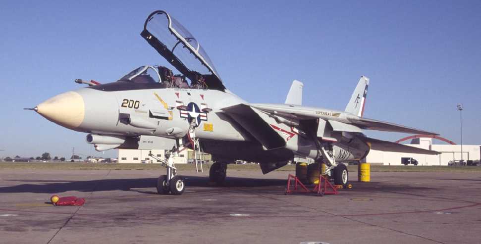
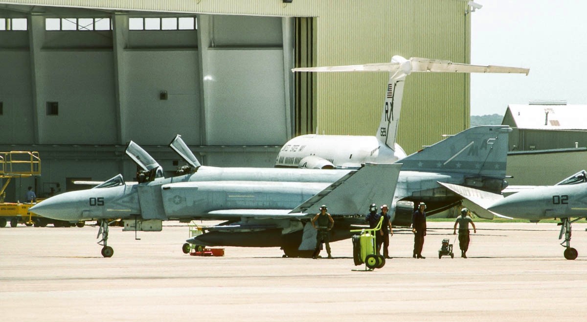
A 10/8/92 photo (copyright Jim Newton, used with permission) of a VF-202 F-14 Super Tomcat (162710 / AF-200 / cn 556) at Hensley Field.
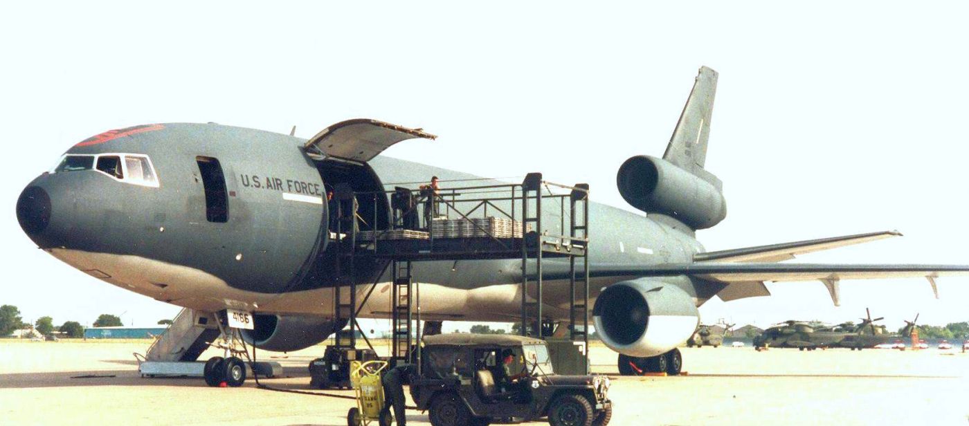
A 1993 photo of a USAF McDonnell Douglas KC-10 Extender at Hensley Field, with several Marine Corps CH-53D helicopters visible in the background.
As part of the Base Closure Act of 1993, Dallas NAS was closed,
and the various reserve squadrons were moved to the former Carswell AFB in Fort Worth, which was renamed Fort Worth NAS.
Ted Waldron (the former ANG Facility Manager at Hensley Field) recalled, “NAS proper still had many WW2 buildings, with face-lifts, when the base closed."
The final B-2 Stealth Bomber intermediate wing section was delivered by LTV to Palmdale on 3/17/94.
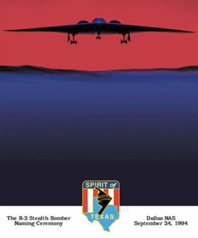
A poster commemorating the 9/24/94 naming ceremony of the 3rd operational B-2 Stealth Bomber as “The Spirit of Texas” at Vought-Dallas (courtesy of Nathan Clay).
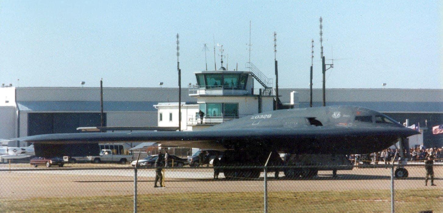
The 9/24/94 photo of the visit of the 3rd operational B-2 Stealth Bomber to the Vought-Dallas facilities for the ceremony naming it as “The Spirit of Texas” (courtesy of Nathan Clay).
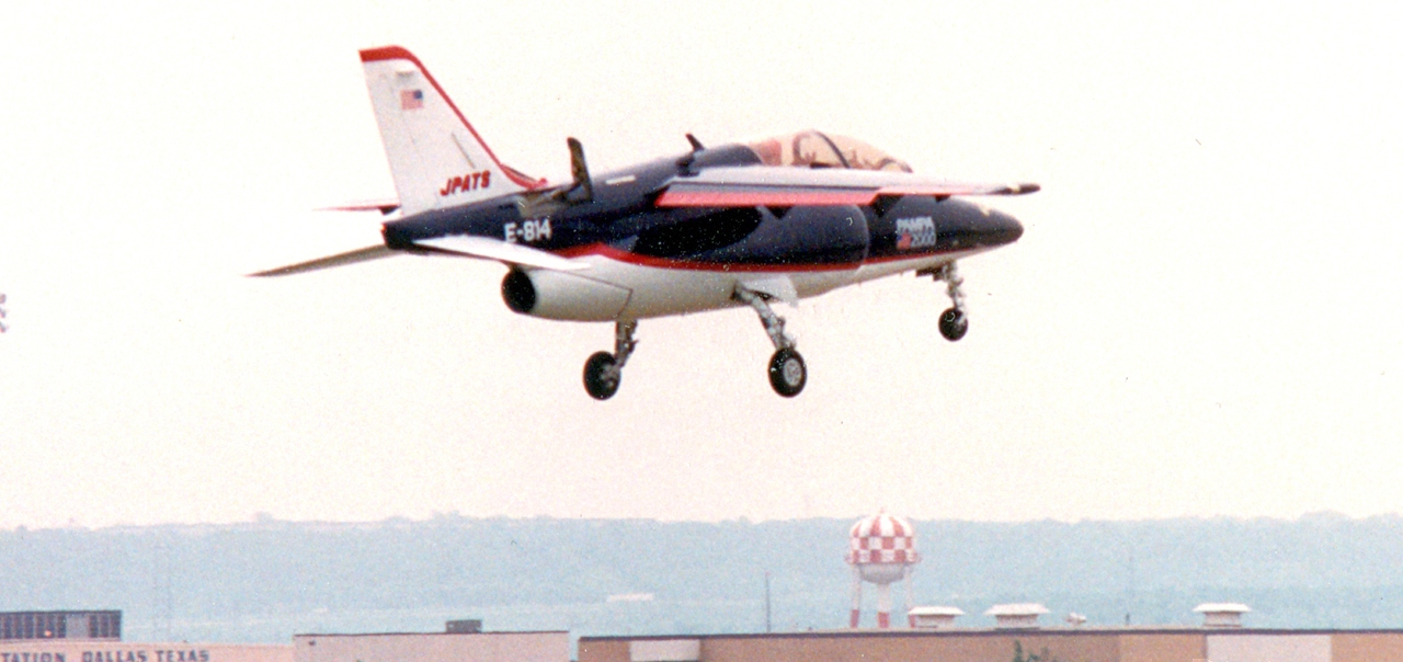
The last photo which has been located showing a fixed-wing aircraft at Hensley Field was a September 1994 photo of an FMA IA-63 Pampa II landing.
The Pampa was Vought Aircraft's unsuccessful entry into the U.S. Joint Primary Aircraft Training System competition.
However “NAS Dallas Hensley” was still depicted on the January 1995 DFW Terminal Area Chart.
A 1995 USGS aerial photo of the area to the south of NAS Dallas,
which has been annotated by David Brooks to show the locations of the large number of WW2-era military airfields.
The last aeronautical chart depiction which has been located of Hensley Field as an active fixed-wing airfield
was on the 1998 DFW Terminal Aeronautical Chart (courtesy of Ron Plante).
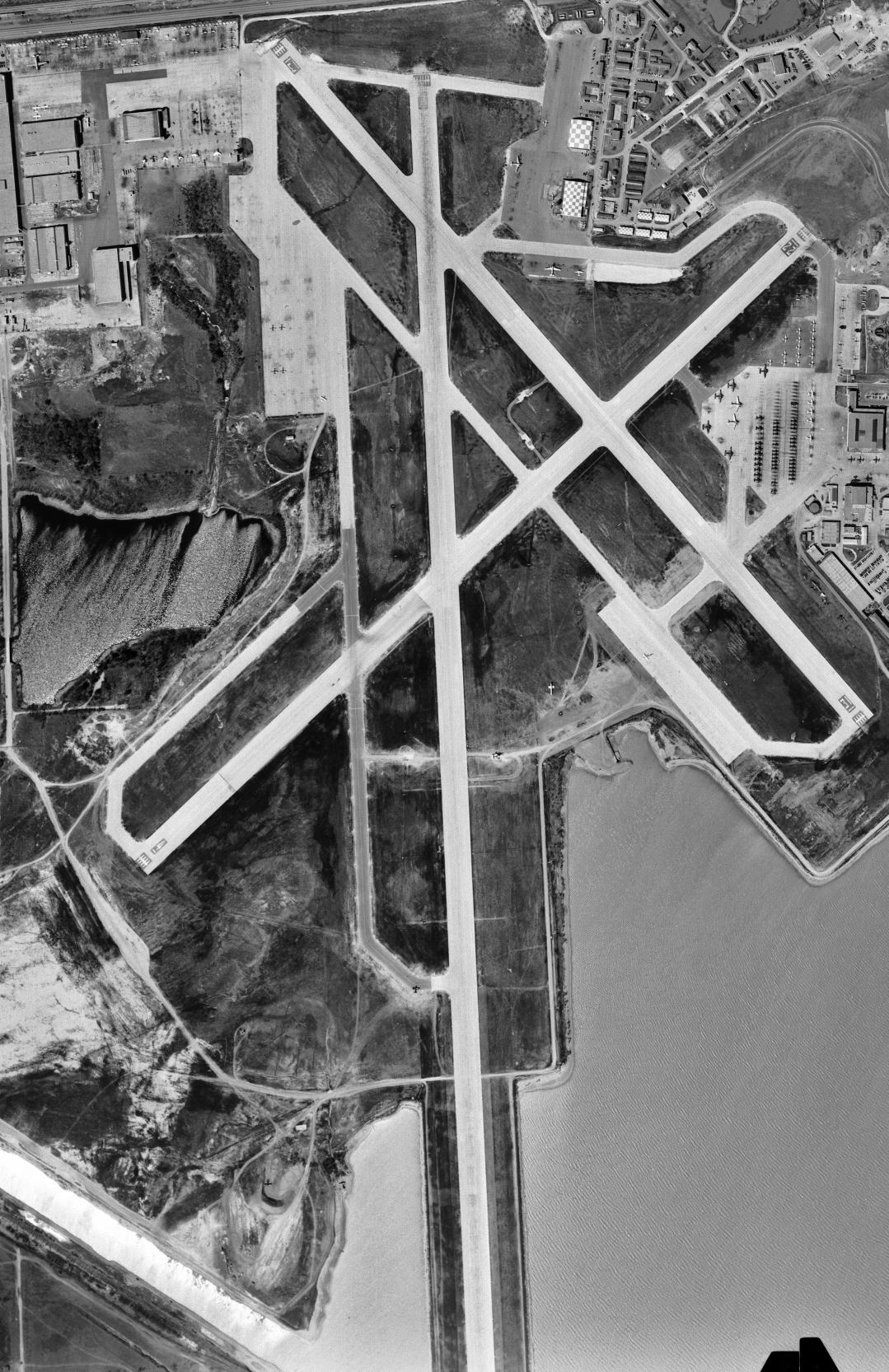
It depicted NAS Dallas Hensley as having 2 paved runways, with the longest being 8,000'.
In 2000 the TX Historical Commission erected a historic sign commemorating Hensley Field.
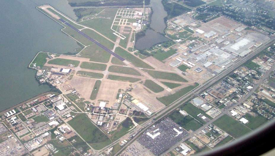
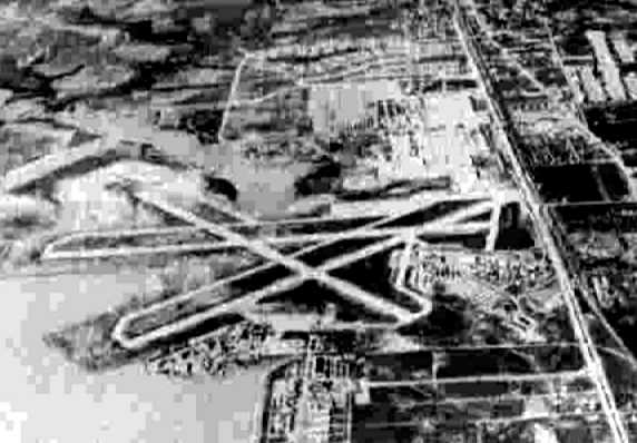
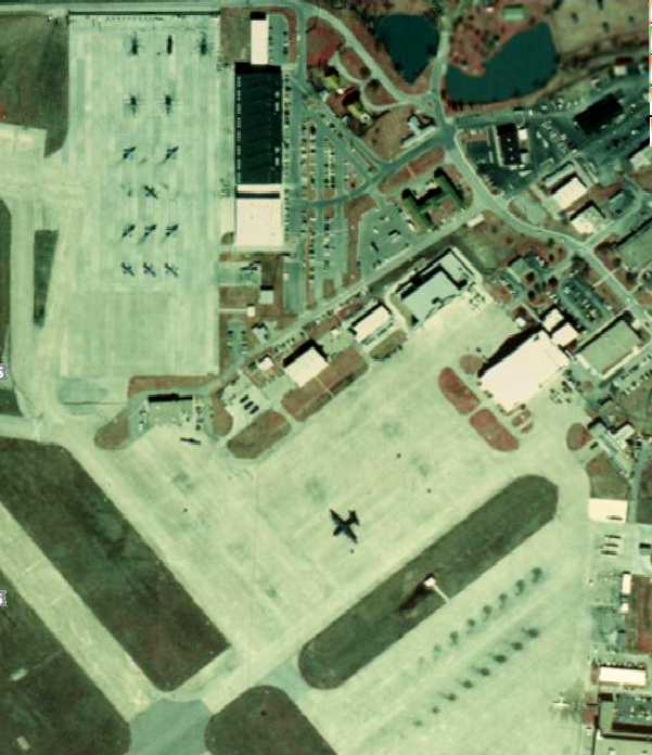
A 2002 aerial view by Paul Freeman looking southwest at Hensley Field.
After NAS Dallas was closed by the military, an attempt was made to reuse the field for business aviation.
As of 2002, although still publicly owned, the former NAS Dallas airfield was operated by a private company as "Millennium Dallas Airport".
One of the former Texas ANG hangars on the northeast corner was modernized by the company,
and was being operated as a terminal catering to business aviation.
Runway 17/35 (8,000' long) was maintained as the sole active runway.
Although the Naval Air Station has officially closed, military aviation continues to be represented on the site by the TX Army National Guard,
which (as of 2002) continued to operate CH-47 Chinook helicopters
from their facility which sits somewhat isolated from the rest of the airfield on the southwest corner of the base.
The Texas ANG also hosts a deployed unit of the Royal Singaporean Air Force, under the project name "Peace Prairie",
at which pilots of the RSAF are trained in Chinook operations.
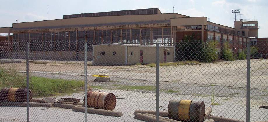
A 2002 photo by Paul Freeman of a sad sight - one of the former Naval Reserve F-14 hangars, rusting away.
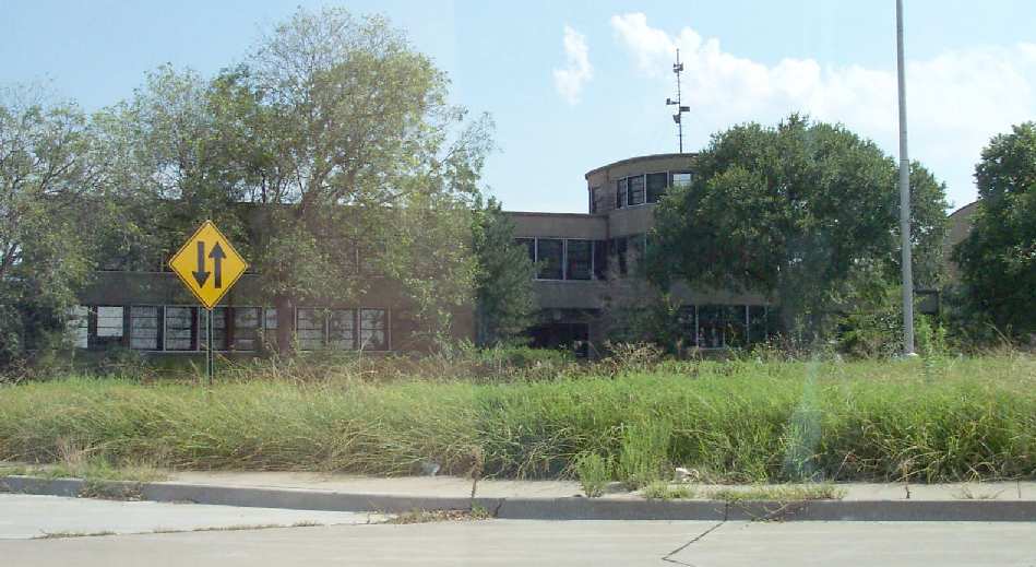
A 2002 photo by Paul Freeman of the former Naval Air Station Headquarters Building, now abandoned & overgrown.
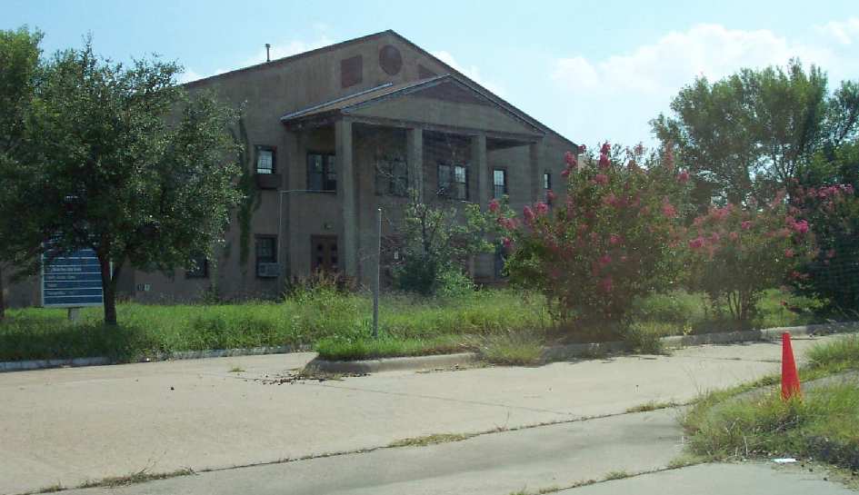
A 2002 photo by Paul Freeman of another former Navy administration building, now also abandoned & overgrown.
Paul Freeman visited the former Dallas NAS site in 2002, to find it a very strange (and sad) sight.
Only portions of the base are still in active use, while the majority of the expansive infrastructure (paid for at great cost by the taxpayers) has been left to completely decay.
In addition to many large hangars, there are entire blocks of the former base office & housing areas in which many large buildings
have been left to the weeds which have taken them over.
Some of these buildings are of relatively recent construction (like what is obviously recognizable as the former base MacDonald's restaurant!).
It is disgraceful that the local politicians have not taken advantage of this base's closure,
and taken more active steps to see that the properties are reused
for some constructive purpose by private industry or local government.
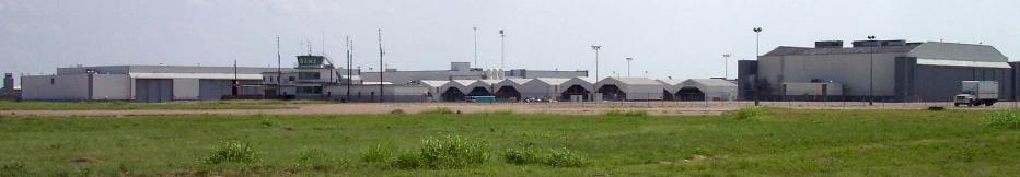
A 2002 photo by Paul Freeman of some of the numerous hangars which still stand
on what has become the Vought Aircraft factory property, as well as the Vought control tower.
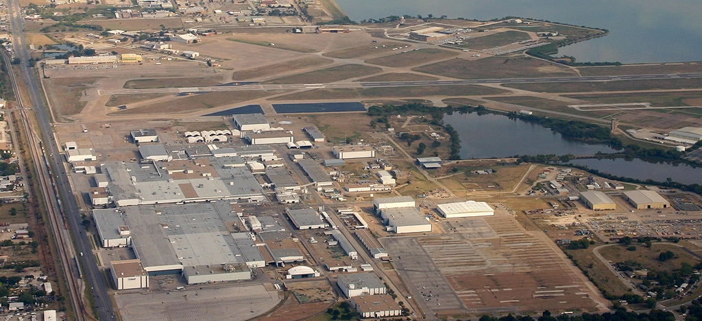
The Vought Aircraft Industries factory is still in operation on the northwest corner of the airfield,
but has not built complete aircraft since the production of the A-7 series came to an end (in the early 1980s?).
Today, the Vought plant produces aircraft structures under subcontract for Boeing & other aircraft manufacturers,
for aircraft including the Bell/Boeing MV-22B Osprey, F-22, C-130, C-17, and the Global Hawk.
A large number of hangars still exist on the Vought property,
leftovers from the days when the factory built & delivered thousands of aircraft from the Dallas location.
At some point between 2002-03, the attempt to reuse the former NAS Dallas as a business aviation airfield
("Millennium Dallas Airport") apparently failed, as the airfield was closed once again,
and depicted on the 2003 Sectional Chart as an abandoned airfield.
Gregg Smith reported of Millennium, “They never made their first rent payment to Dallas & everything sunk into lawsuits.”
Hensley Field's history of 70 years as an airfield had apparently come to an end, for the time being.
In 2004, news reports indicated that the Vought company had obtained a long-term extension
to their occupancy of the plant adjacent to Hensley Field,
and that part of the deal was the possibility of reopening the closed Hensley Field runway,
to facilitate air shipments of large aerostructures.
Vought's Gregg Smith reported in 2005, “Hensley Field Runway 17/35 will reopen in the Summer of 2005.
DMJM Aviation, under contract to the City of Dallas, has completed the A/E work & construction bids have been received.
I expect a construction contract will be authorized in the next several weeks, with a first VFR flight in June of 2005.
The ILS system will be operational by the fall. We intend to deliver structures via C-17s & C-5s.”
Christopher Trott reported in March 2005, “I went by NAS Dallas today.
The City of Dallas recently approved a $500,000 appropriation for the replacement of the roof
on Buildings 25, 26, and 27 in addition to other 'reconstruction' activities
From the wording of the City Council notes, it appears that the airfield will maintain its status as such
and that they will continue to maintain the lighting system
(I saw several vehicles from the City of Dallas at the threshold lights for Runway 18 doing maintenance).
With the reconstruction of some of the buildings directly off Jefferson (north end of the field, across from Vought)
I believe that they may be preparing the entire facility for re-occupation by various companies.”
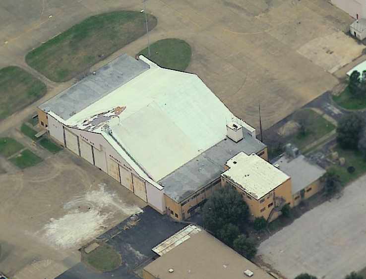
A circa 2002-2005 aerial view looking west at a large abandoned hangar
on the northeast side of Hensley Field which still bears the legend “Texas Air National Guard”.
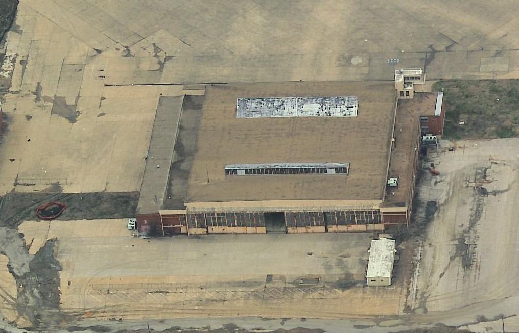
A circa 2002-2005 aerial view looking west at a large abandoned hangar on the southeast side of Hensley Field.
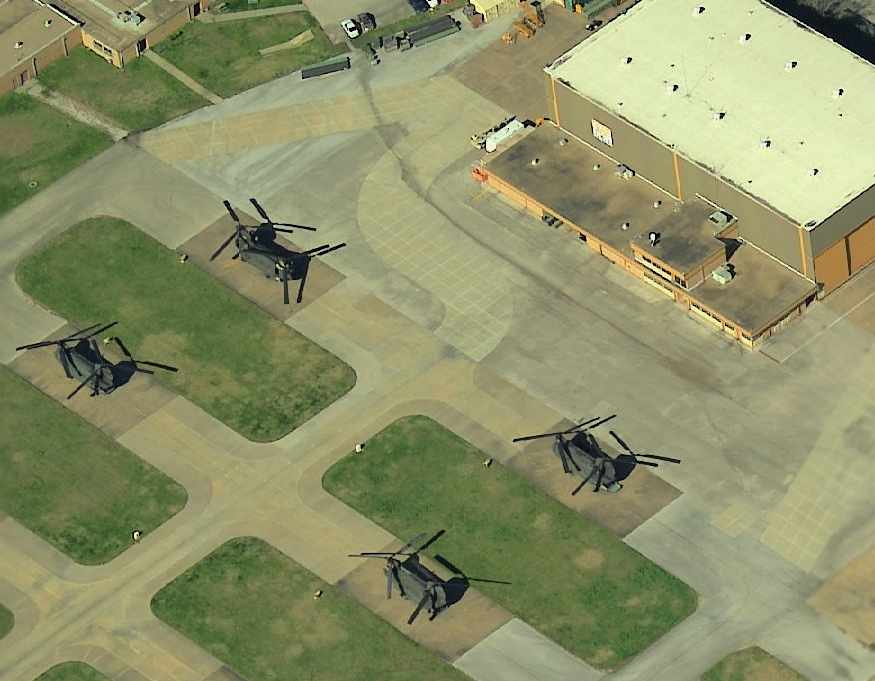
A circa 2002-2005 aerial view looking west at 4 CH-47 Chinooks at the National Guard facility on the southwest corner of Hensley Field.
The 2004 DFW Terminal Aeronautical Chart (courtesy of Jonathan Westerling) depicted Hensley Field as an abandoned airfield, with the Taylor Army Heliport depicted to the west.
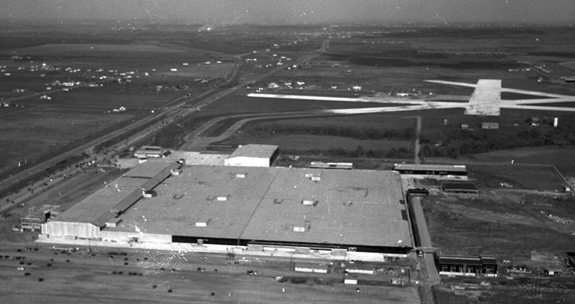
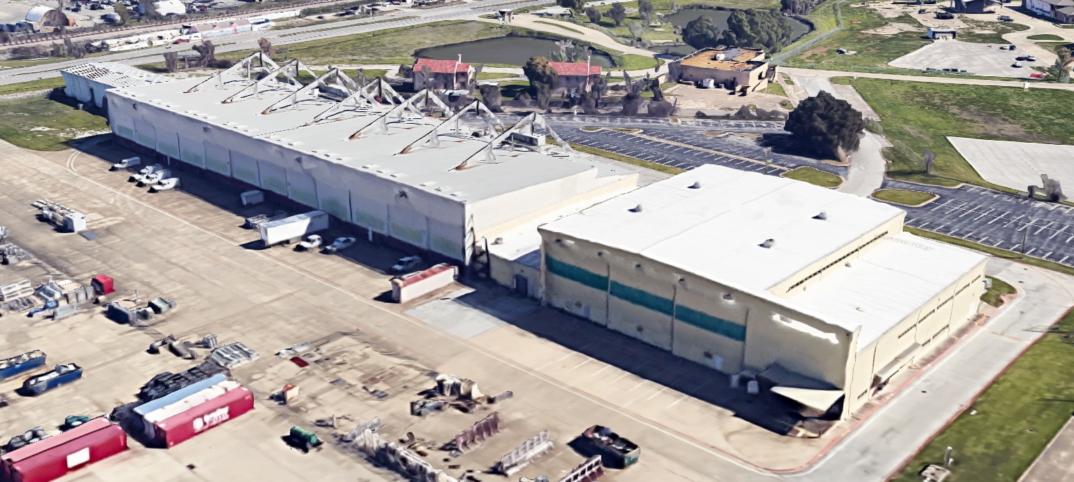
A 10/15/05 aerial view by Andreas Mueller looking east at the huge former Vought aircraft factory on the west side of Hensley Field.
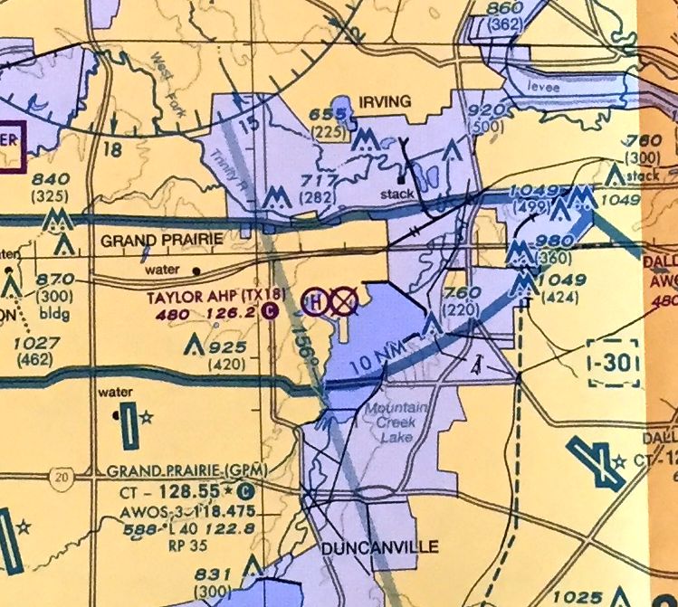
The March 2009 DFW Terminal Aeronautical Chart depicted Hensley Field as an abandoned airfield, with the Taylor Army Heliport depicted to the west.
A 12/27/09 showed only a single aircraft (a UH-1 Huey) on the ramp at the National Guard facility on the southwest corner of Hensley.
All of the other helicopter parking spots were empty.
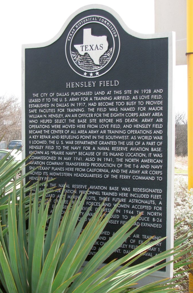
A 3/6/10 photo of the TX Historical Commission's historic sign commemorating Hensley Field.
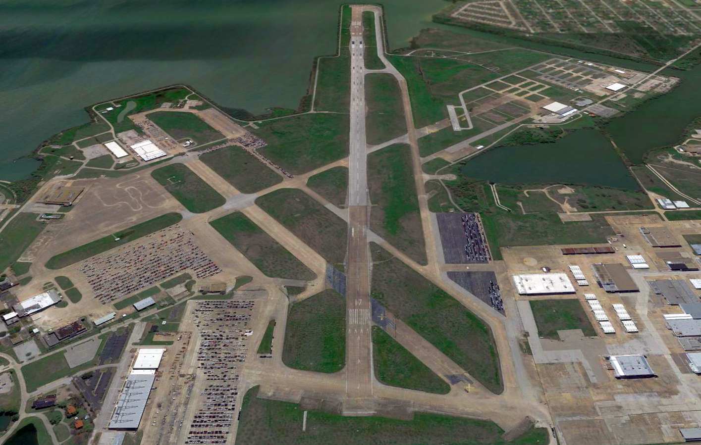
A 2015 aerial view looking south at the massive aviation facilities of the former Hensley Field.
What a shame to see this massive amount of taxpayer-funded aviation infrastructure going to waste.
In 2018, Nathan Clay reported, “Recently the runway has been getting used as an overflow parking lot for the nearby car manufacturers/car dealers etc.
But this event [the DallasHalfMile auto race] is the only time I’ve seen the runway actually used for anything quasi beneficial or fun for the community since the 1993 airshow.”
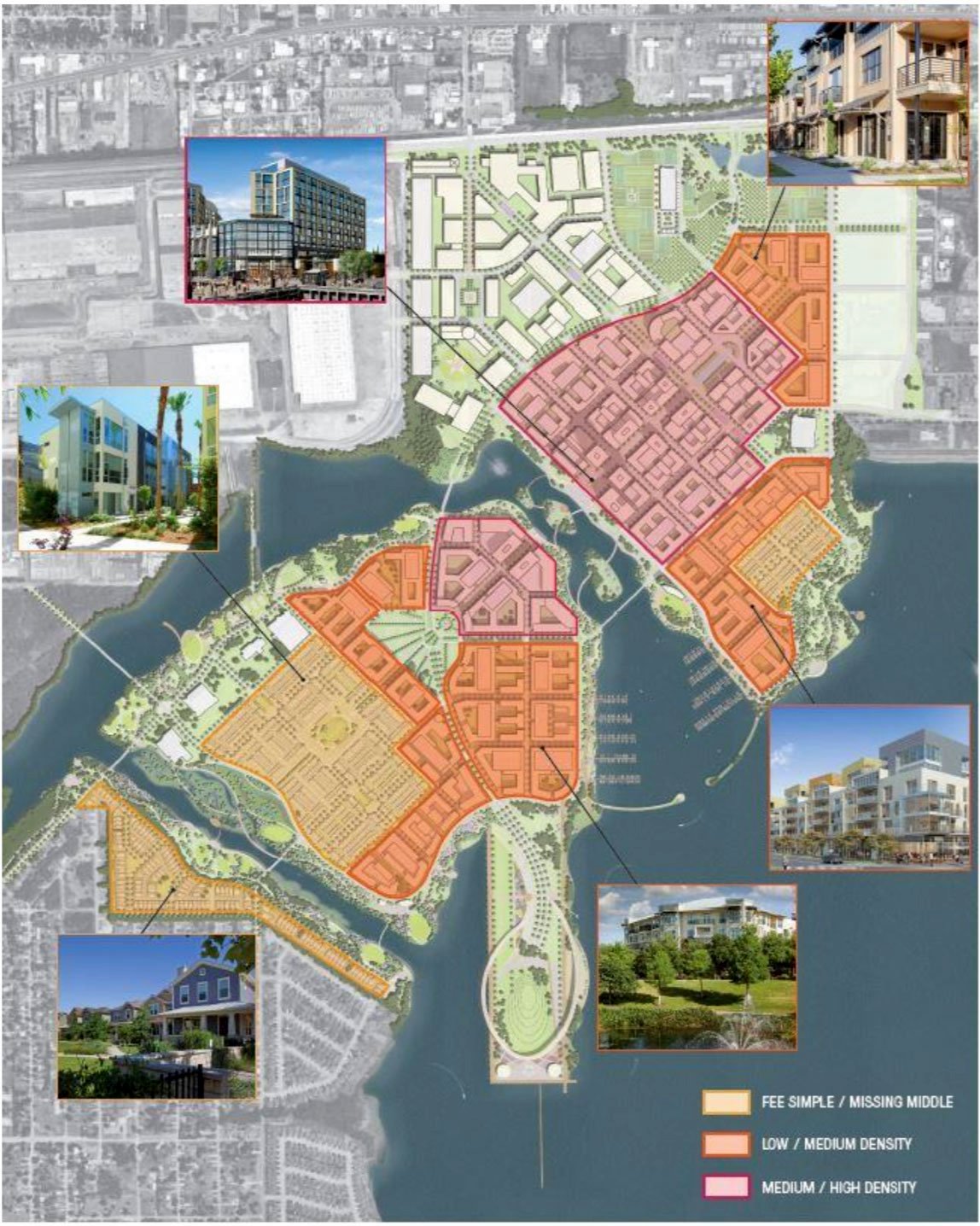
An undated image of proposed dense housing which could cover the site of Hensley Field (courtesy of Nathan Clay).
What a shame it would be to see the massive amount of aviation infrastructure (paid for by the taxpayers) all removed.
Nathan Clay reported in 2022, “Home Depot is using the former NAA/LTV buildings as a distribution center.
Dallas city planners are working to repurpose the rest of the airfield, adding waterfront businesses, restaurants, apartments, marina
and convert the Base Commander’s Quarters to a museum & use the hangars for a brew pub or open-air market etc.”
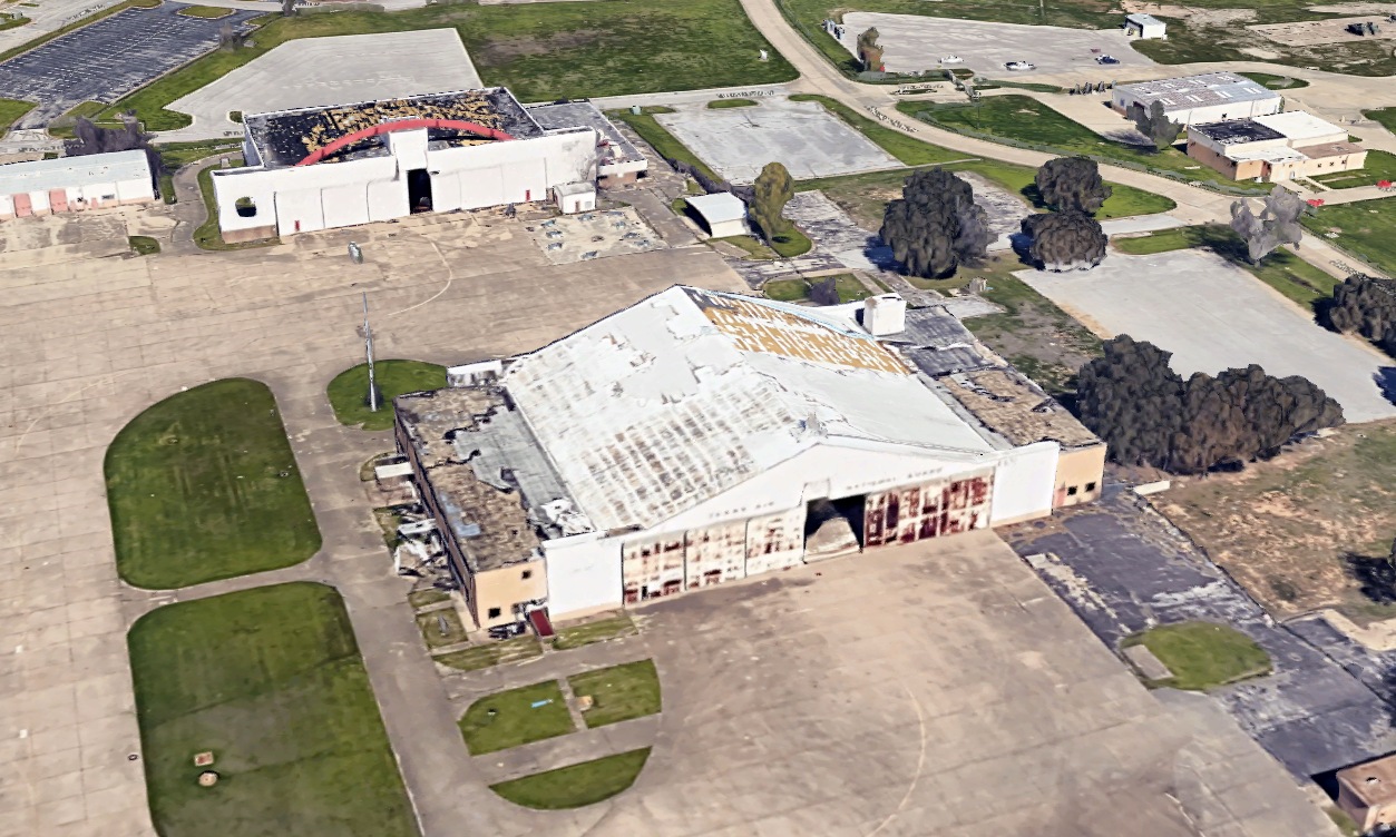
A circa 2022 3-D aerial image of the former TX Air National Guard hangars on the east side of Hensley Field.
A circa 2022 3-D aerial image of former hangars on the northeast side of Hensley Field.

A 2025 photo looking southeast at former hangars on the northeast side of Hensley Field.
A 2025 aerial photo showed the massive Vought aircraft factory buildings were removed at some point between 2022-2025, and replaced by 2 Home Depot distribution buildings.
Thus continuing the removal of America's aviation manufacturing infrastructure.
See also:
http://www.vpnavy.com/nasdallas.html
http://www.raytheon.com/feature/major/part1.htm
http://www.vought.com/y40-50/html/dallas40.html
http://www.vought.com/y50-61/html/dallas_50.html
http://www.vought.com/y61-72/html/dallas_61.html
____________________________________________________
Or if you prefer to contact me directly concerning a contribution (for a mailing address to send a check),
please contact me at: paulandterryfreeman@gmail.com
If you enjoy this web site, please support it with a financial contribution.
____________________________________________________
This site covers airfields in all 50 states.