Abandoned & Little-Known Airfields:
Texas: El Paso area
© 2002, © 2025 by Paul Freeman. Revised 9/11/25.
This site covers airfields in all 50 states: Click here for the site's main menu.
____________________________________________________
Please consider a financial contribution to support the continued growth & operation of this site.
(Original) El Paso Municipal Airport (revised 4/26/13) - West Texas Airport / Horizon Airport (revised 9/11/25) - Hueco Airport (revised 9/11/25)
MacGuire Ranch (revised 1/31/25) - Skyport Airport (revised 9/11/25) - The Westerner Inn Airpark (revised 10/22/21)
____________________________________________________
The Westerner Inn Airpark, El Paso, TX
31.838, -106.568 (West of Downtown El Paso, TX)
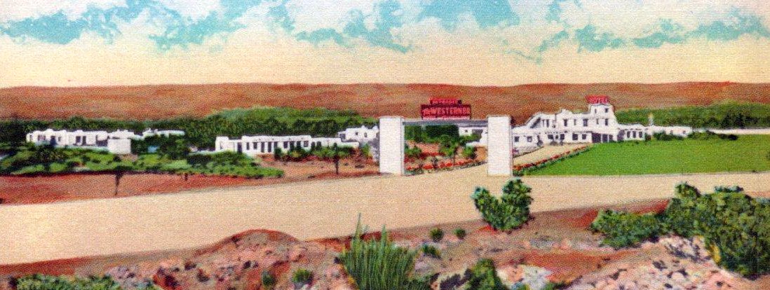
A circa 1940s colorized postcard image of The Westerner Inn & Airpark (courtesy of Bill Quinn).
Bill Quinn reported, “A Password journal of the El Paso County Historical Society indicated this dude ranch was once known as El Ranchotel (1942-46).”
A 1946 aerial photo showed several buildings of the dude ranch, but did not yet show the eventual airfield.
Bill Quinn reported, “Apparently its name was changed from El Ranchotel in 1946, as indicated by a 1946 corporation filing for 'The Westerner Inn of El Paso'.”
The Westerner Inn Airpark was not depicted on 1946/47/48/49/50/52/55 El Paso Sectional Charts (presumably overlooked as a private airfield).
The earliest depiction which has been located of the Westerner Inn Airpark was a circa 1940s colorized postcard image (courtesy of Bill Quinn).
It was captioned, “The Westerner Inn, El Paso. The southwest's finest desert resort, horseback riding, tennis courts, swimming pool,
2,400' airstrip, 50 lovely air conditioned rooms equipped with combination tubs & shower. Six miles west of El Paso on Highway 80.”
The postcard image showed the hotel buildings, along with a dirt clearing in front which may have been part of the unpaved runway.
Bill Quinn reported, “A Password journal of the El Paso County Historical Society indicated, 'At that time the Westerner was completely surrounded by desert
and was, it is reputed, a place where movie stars & other famous persons stayed while they were negotiating Juårez [MX] 'quickie' divorces.'”
Bill Quinn reported, “During my days at TWC (1950-54) this dude ranch was a seldom-visited venue for the students because it was 'too high-class' for a bunch of college-kids.”
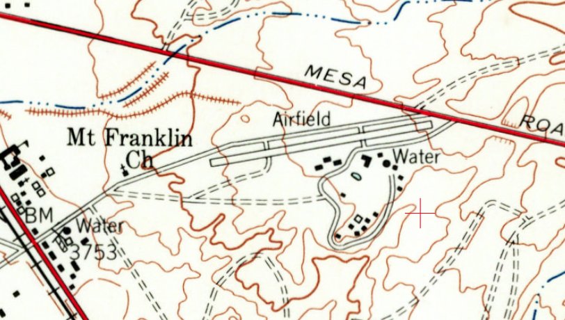
The only topo map depiction which has been located of the Westerner Inn Airpark was on the 1955 USGS topo map.
It depicted a single northeast/southwest runway, generically labeled as “Airfield”, with a cluster of buildings to the south.
A 1955 aerial view depicted the Westerner Inn Airpark as having a single northeast/southwest runway, generically labeled as “Airfield”, with a cluster of buildings to the south.
There were no aircraft visible on the field, nor any other indication of recent aviation use.

The only photo which is available of the Westerner Inn Airpark was a 1956 aerial view (courtesy of Michael McElroy).
It depicted a single northeast/southwest runway, with a cluster of buildings to the south.
There were no aircraft visible on the field, and the western runway end had a closed-runway “X” symbol, so the airfield may have been closed by that point.
Bill Quinn reported, “No information was been found on when The Westerner Inn closed its operations.”
A 1967 aerial photo showed Interstate 10 had been built over the western portion of the former Westerner Inn Airpark runway,
but traces still remained of the eastern portion, and the Inn buildings remained intact.
A 1991 aerial photo showed the Westerner Inn buildings had been removed at some point between 1967-91,
replaced by a Walmart & other retail buildings & parking lots.
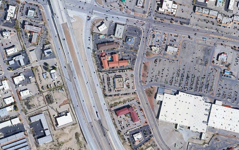
A 2020 aerial view shows no trace remaining of The Westerner Inn Airpark, with the site covered by Interstate 10, a Walmart, and other buildings.
Bill Quinn reported, “An on-the-ground inspection on 3/8/21 revealed that most of the former buildings (lodge & outlying apartments) of The Westerner Inn
were located in the parcel of land now containing the Walmart Supercenter at 7555 North Mesa Avenue.”
Thanks to Bill Quinn for pointing out this airfield.
___________________________________________________
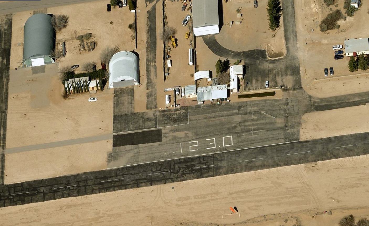
West Texas Airport / Horizon Airport (TX04 / T27), El Paso, TX
31.72, -106.24 (Southeast of El Paso, TX)
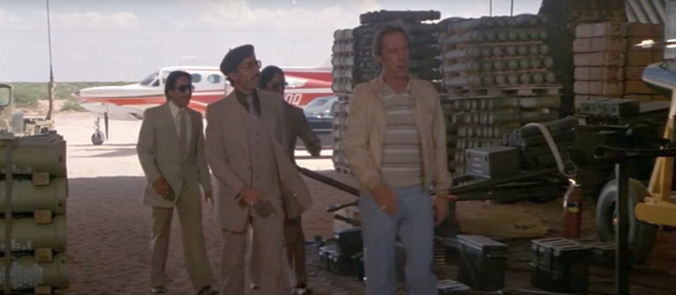
A 1982 still from the Chuck Norris movie “Lone Wolf” filmed at the West Texas Airport.
A 1967 aerial view did not yet show any sign of this eventual airport.
Dan Eikleberry recalled, “Back in 1976, a local air conditioning repair company called Barrett Refrigeration was operating in a hangar
(because the owner was also a pilot & had airplanes) on El Paso International Airport.
Phil Barrett, the owner, bought some land way out in the desert near Horizon City.
Phil always wanted to build an airport where people could build houses & hangars (a sky-park) and he was the Chapter president of our local EAA Chapter.
Phil enlisted the aid of many EAA members as well as his own family & anyone who would help. In 1976-77, we all chipped in.
We drove tractors with blades & scraped the ground flat. We all walked the runway & picked up rocks & bottles & anything that didn't belong on a runway.
Phil bought a big machine that corrugated rolls of steel into giant arches & started building hangars that looked like Quonset huts.
The runway was dirt at first, and about half the size you see [on recent aerial photos].
Maybe 3,000' at best, and the east end was the gas pipeline.
There were no paved roads out there in those days... we used the dirt road along the gas pipeline to get to the airport.”
No airport was yet depicted at this location on the January 1977 El Paso Sectional Chart.
The earliest depiction which has been located of West Texas Airport was a 1982 still from the Chuck Norris movie “Lone Wolf” which was filmed at the airport.
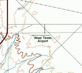
The 1983 USGS topo map depicted West Texas Airport as having one 4,000' east/west runway.
Dan Eikleberry recalled, “At one point, Phil Barrett had a line on a Convair 880 & asked if I would fly it into West Texas if he bought it (mid-1980s).
I said I would do it (rated in CV-880/990) but he never bought it.
Instead he bought that Vickers plane & he & another pilot flew it into West Texas Airport but somehow they crashed it upon landing, causing the damage to the wing.
He started building an aviation museum behind that Vickers,
and showed me a very old computer inside that he claimed had something to do with landing the Apollo 'Eagle' on the moon in 1969.”
Diego Britton recalled, “West Texas Airport... I used to visit the museum there, and also liked to sit & watch the gliders fly around as a kid.”
'The earliest aerial photo which has been located of West Texas Airport was a 1984 aerial view.
It depicted West Texas Airport to have a single asphalt east/west runway, with an asphalt ramp, and a significant number of buildings & at least 8 aircraft on the north side.

The earliest aeronautical chart depiction which has been located of West Texas Airport was on the August 1985 El Paso Sectional Chart.
It depicted West Texas Airport as having a single 4,100' paved east/west runway.
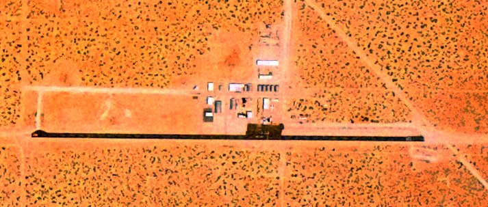
The earliest aerial photo which is available of West Texas Airport was a 5/29/91 USGS aerial view.
It depicted West Texas Airport to have a single asphalt east/west runway, with an asphalt ramp, and a significant number of buildings & at least 1 aircraft on the north side.
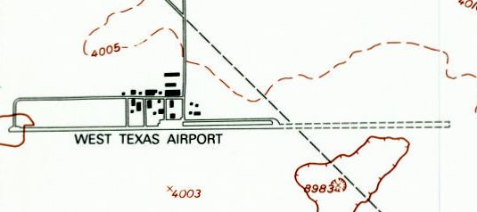
The 1995 USGS topo map of West Texas Airport showed that an unpaved expansion had been added to the east end of the runway at some point between 1983-95.
A significant number of buildings were depicted on the north side of the field.
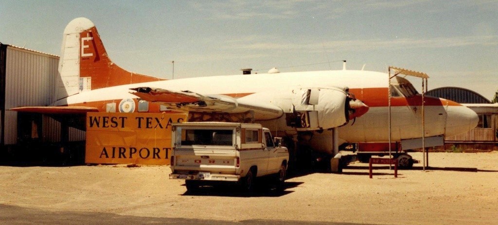
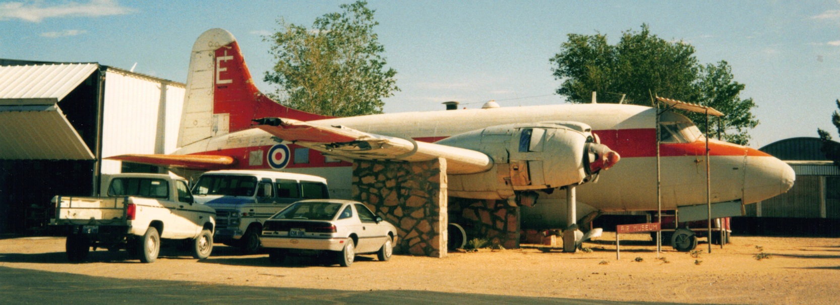
A 1995 photo by Dave Welch of a Vickers Varsity T.1 (N65338), part of the display collection of the West Texas Air Museum.
Note the Varsity's damaged wingtip.
A 3/6/96 aerial view looking southeast showed West Texas Airport to have a single asphalt east/west runway, with a significant number of buildings on the north side.
At least 3 aircraft (possibly display aircraft) were visible among the buildings.
A June 2001 photo by Michael Kersten of a Vickers Varsity T.1 (N65338) of the West Texas Air Museum at West Texas Airport.
A 3/8/02 aerial view showed the eastern expansion of the West Texas Airport runway had been paved with asphalt at some point between 1996-2002,
lengthening the paved surface to a total of 7,000'.
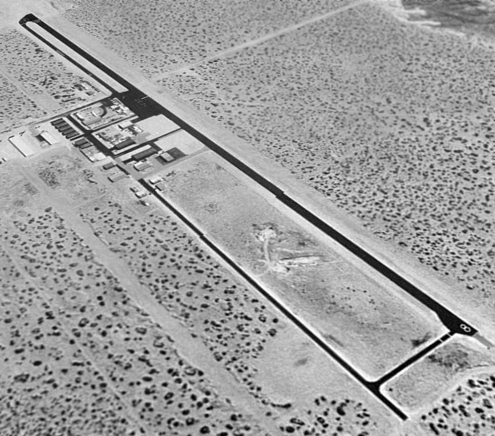
A 2003 aerial photo showed the threshold for West Texas Airport's Runway 8 had been displaced 600' toward the east.
According to its FAA Airport/Facility Directory data, as of 4/28/07 West Texas Airport conducted an average of 85 takeoffs or landings per day,
and had a total of 90 based aircraft: 76% single-engine, 2% multi-engine, 11% gliders, and 11% ultralights.
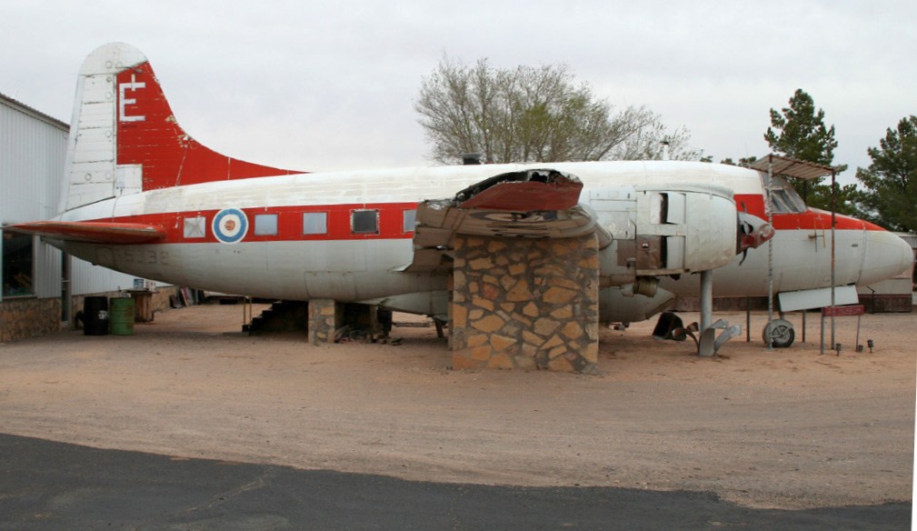
A 3/5/08 photo by Dave Meegan of a Vickers Varsity T.1 (N65338) of the West Texas Air Museum at West Texas Airport.
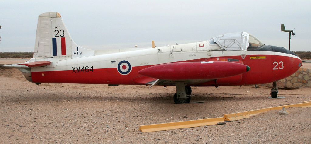
A 3/5/08 photo by Dave Meegan of a Hunting Jet Provost T.3A (XM464) of the West Texas Air Museum at West Texas Airport.
Manny DeReyes reported, “Phil Barrett & his family owned West Texas Airport & built it up until Mr. Barrett's death on 12/17/08.
Many people knew Mr. Barrett, and he was a gentleman who loved aviation & promoted it with zeal.
El Paso lost a great aviation person in Mr. Barrett, and many people still remember him & the numerous ways he enriched aviation & his community.
T27 survived several years” after Barrett's passing.
The airport was renamed Horizon Airport presumably after the passing of Phil Barrett.
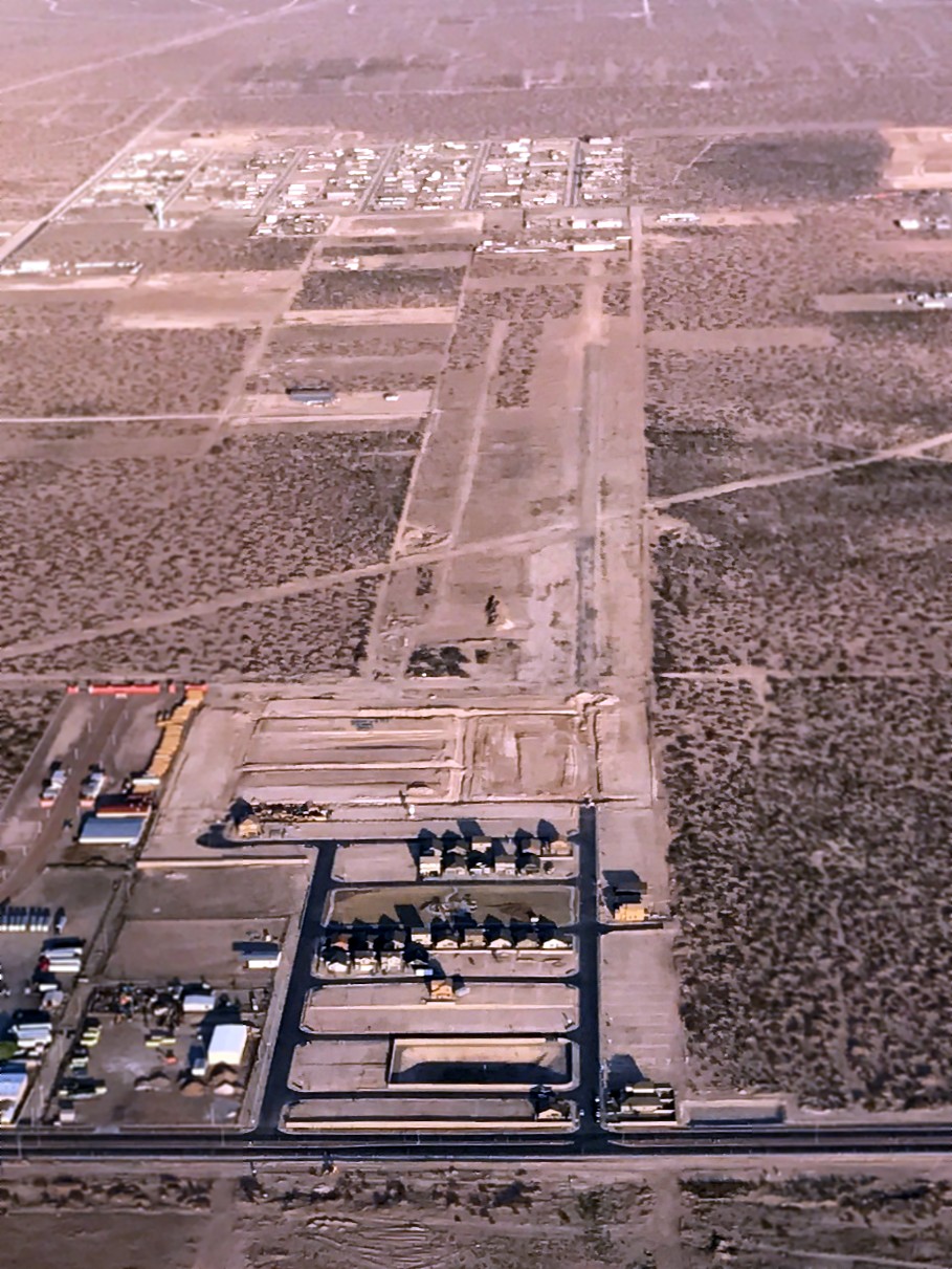
An undated (circa 2010-2014) aerial view looking north at Horizon Airport, showing it devoid of aircraft.
An 11/9/11 aerial view showed Horizon Airport's threshold for Runway 8 had been displaced once again, now to 1,500', shortening the runway to only 5,400'.
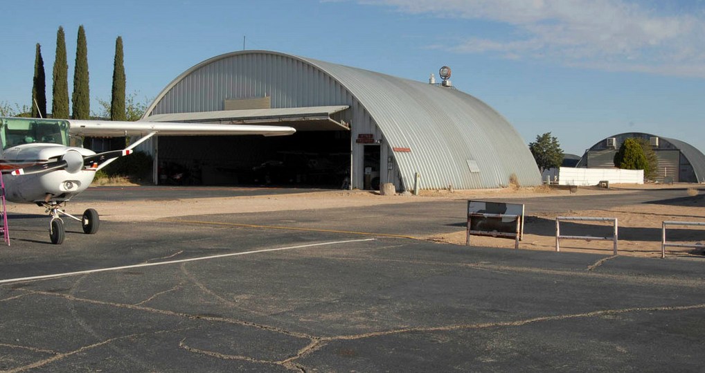
An undated (2012 or earlier) photo of a Cessna 150/152 in front of a Quonset hut hangar at Horizon Airport.
An undated (2012 or earlier) photo of an Aero Commander Callair A-9B at Horizon Airport, used by the El Paso Soaring Society to launch its gliders.
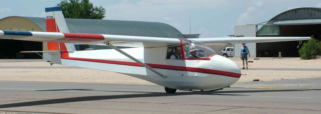
An undated (2012 or earlier) photo of the the El Paso Soaring Society's Schweitzer 2-33A ready to be towed for takeoff at Horizon Airport.
Manny DeReyes reported, “T27 was taken off the Airport Facilities Directory in 2012.”
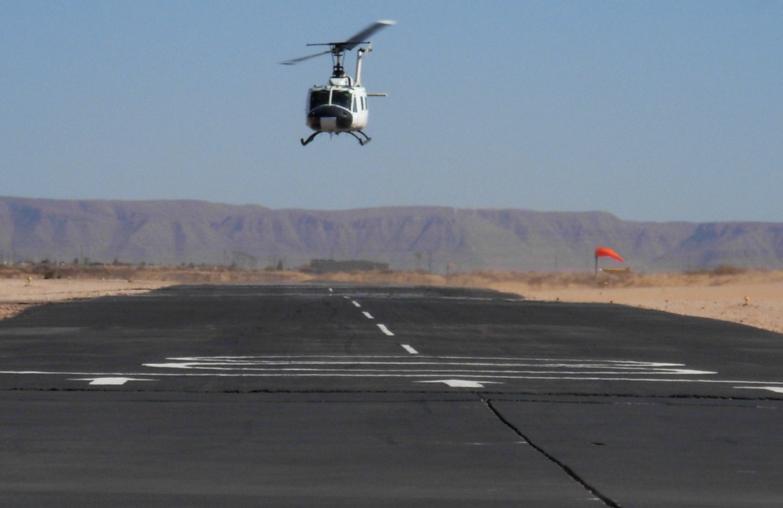
An undated (2014 or earlier) photo of a Bell UH-1 Huey above the Horizon Airport runway.
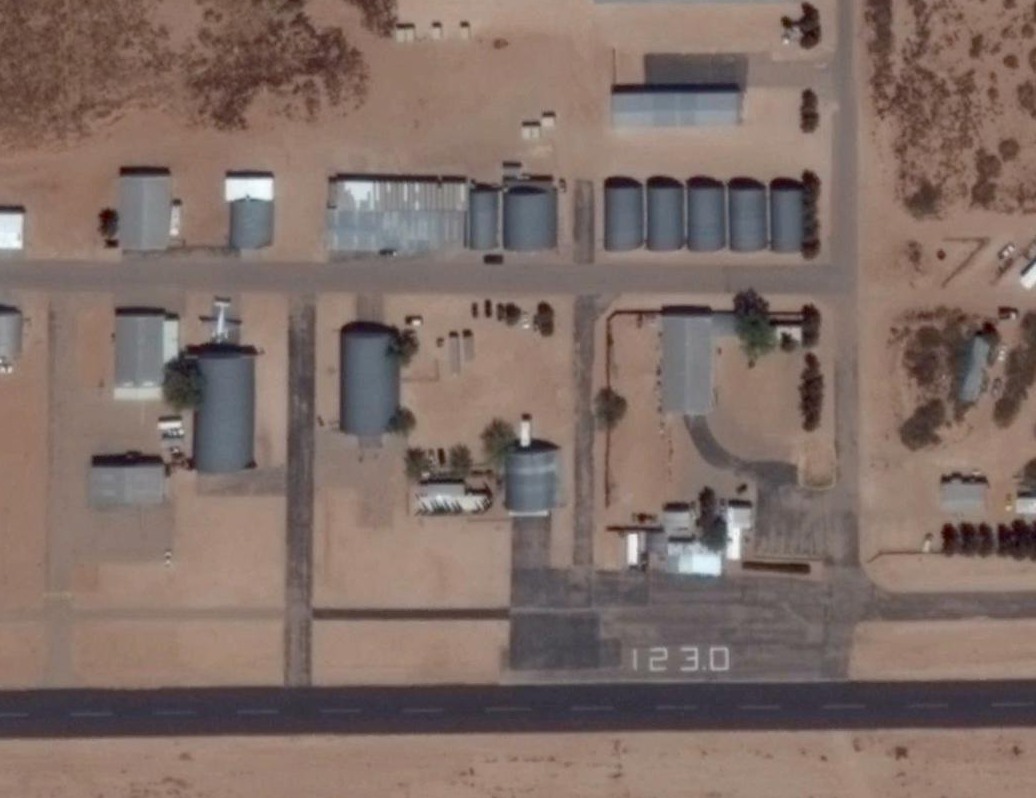
The last photo which has been located showing an aircraft at Horizon Airport was an 3/30/14 aerial view,
which showed one twin-engine aircraft parked among the hangars, and the Unicom frequency painted on the ramp.
Horizon Airport was evidently closed in 2014 (for reasons unknown),
as a 4/7/14 aerial photo showed runways marked with closed-runway “X” symbols.
Dan Eikleberry observed, that photos showed “Construction on pipeline mid-runway, 5/2/14.”
Stepping through photos, it appears the buildings were all dismantled between May-July, 2014.
In October 2014: Four hangars GONE, frequency painted out, X on runway!
The pipeline work was completed, the runway was repaired, but... the runway was still closed.
Sad loss. Another aviation dream disappeared & another airport gone forever.”
As of 2014, the website for the El Paso Soaring Society (previously based at Horizon Airport)
says “The El Paso Soaring Society is currently not flying.”
Wikipedia says Horizon Airport was owned by the family of Phil Barrett.
The 2014 Sectional Chart depicted Horizon Airport as an abandoned airfield,
but note the cutout remained around it for the El Paso Class C airspace.
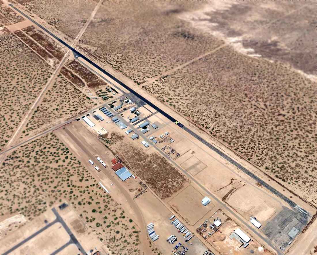
A 5/2/14 aerial view looking southeast depicted Horizon Airport as remaining completely intact,
though devoid of any aircraft, and with the runway marked with closed runway “X” symbols.
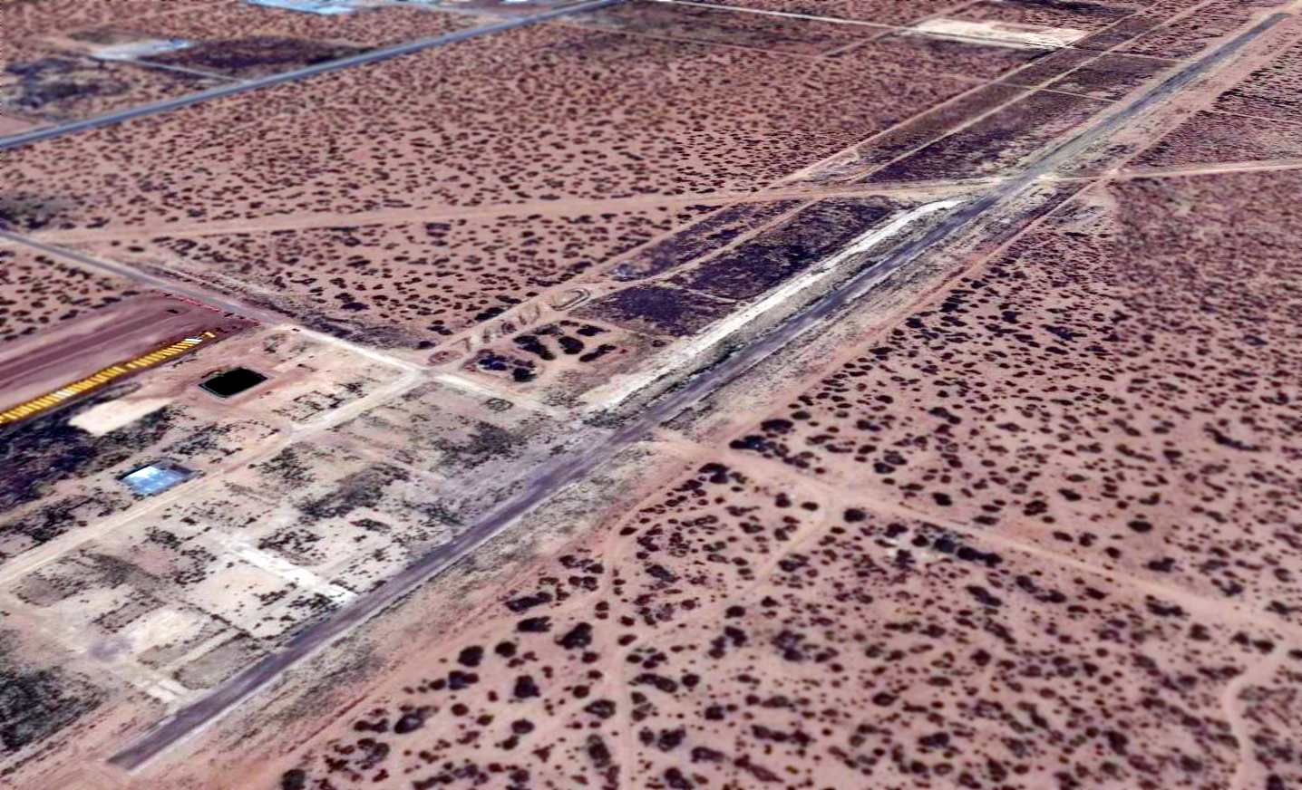
A 8/30/15 aerial view looking northeast at the site of Horizon Airport showed a shocking transformation from the previous year's photo,
with the runway pavement having been removed, and all of the airport hangars & buildings scraped away.
Why would anyone go to such effort & expense to remove all of that infrastructure?
Diego Britton reported in 2015, “I was out driving & remembered the old West Texas / Horizon Airport.
I know the airport had closed down, but I was curious to see what had become of it in the year since. What I found was shocking.”
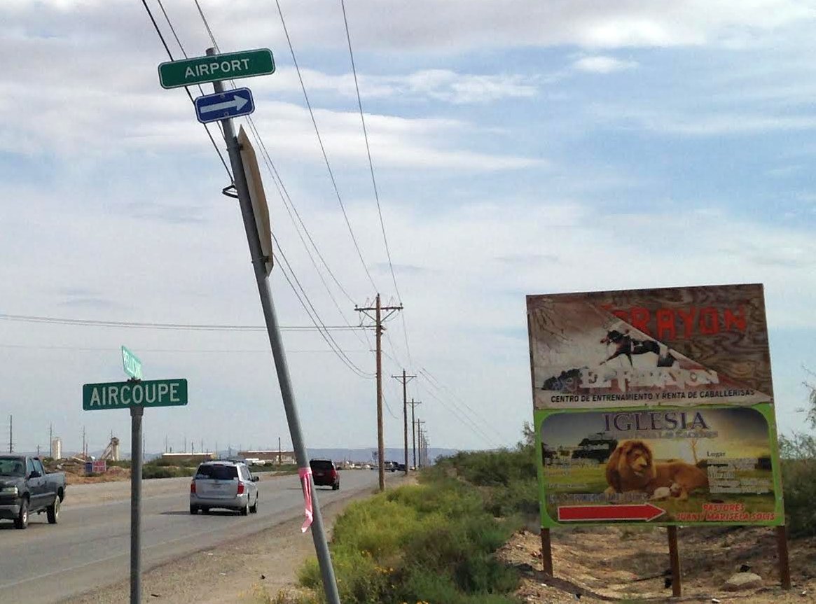
A 2015 photo by Diego Britton at the entrance to Horizon Airport, “of the street signs at the entrance of the old airport.
There are no signs indicating there was an airport here whatsoever, other than these two.
The road leading down into the airport is no longer paved, and has been overgrown with desert shrubbery. It passes by what looks like a school bus graveyard.”

A 2015 photo by Diego Britton of a building at the site of Horizon Airport.
Diego reported, “Driving in, this is the only building that remains standing at the site. I believe it was the old office.
The taxiways are no longer paved as well, and it looks as it an airport was never present there.
It looks as if squatters have taken over it, as there was a jacket laying on the ground (visible in this photo, it is the blue object lying in front of the bush in the center)
and a mattress lying next to the entrance of the building on the far left. Seeing these things made me a little apprehensive about entering the building, so I decided not to.”
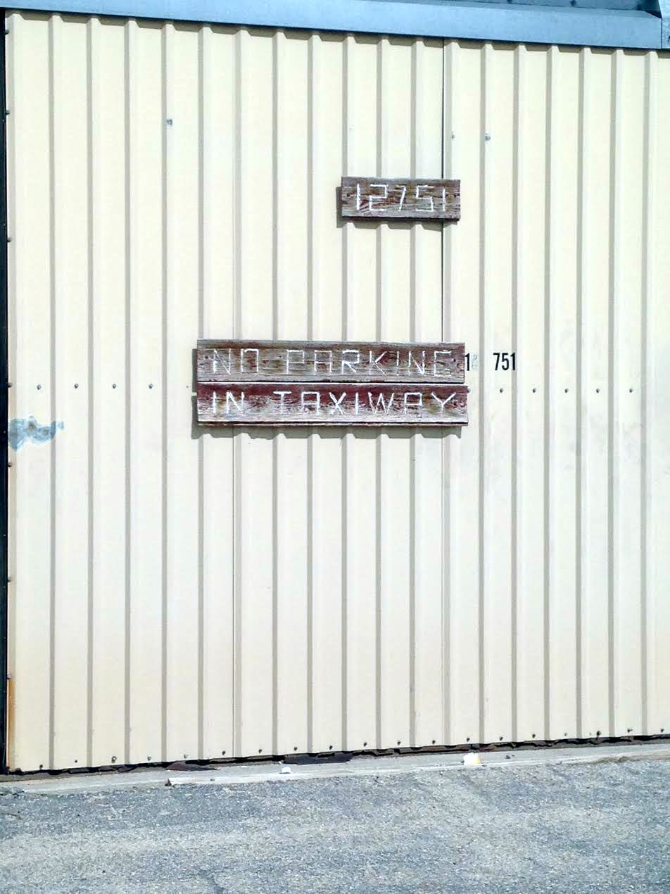
A 2015 photo by Diego Britton of a sign on the only building remaining at the site of Horizon Airport.
Diego reported, “The only indication that an airport was ever present here is the sign on the wall.”
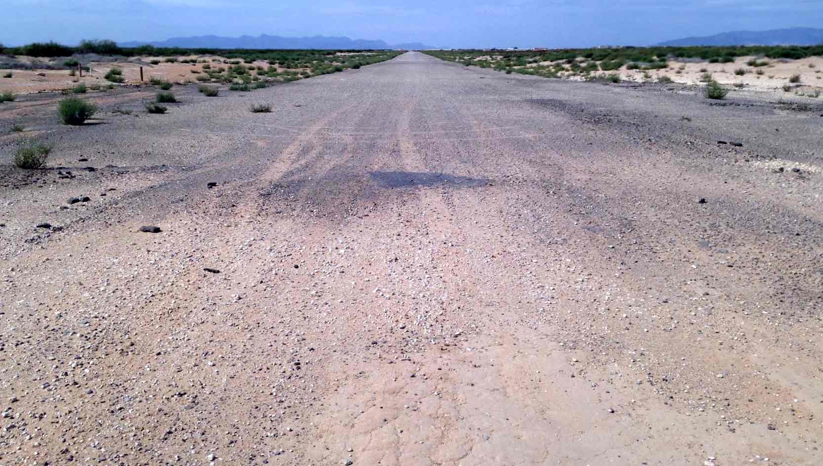
A 2015 photo by Diego Britton looking west at the former Horizon Airport runway.
Diego reported, “At the east end of the runway, few signs of any sort of pavement remain.
The upper layer of pavement has been razed (except for a few small patches here at the East end), and all that remains of the runway is a layer of gravel.
This is a photo of the end of the runway, the east end looking west.
At the west end of the runway, a large ravine has been cut where the runway used to be, and the original west end is no longer present.
In the span of one year, any sign that the West Texas / Horizon Airport ever existed has vanished.
It's a shame, it was a great place to go visit, and to fly for sport in & out of.”
A 3/5/17 aerial view by Mark Ellman looking east at the site of Horizon Airport. Mark observed, “You can see what used to be the runway & homes starting to be built.”
A 2020 aerial view showed houses covering the Horizon Airport site.

A 2024 photo looking east along Runway Avenue, the former Horizon Airport runway.
The Horizon Airport site is located at the intersection of Aircouple Road & Starduster Road.
Thanks to Micheal McMurtrey for pointing out this airfield.
___________________________________________________
(Original) El Paso Municipal Airport, El Paso, TX
31.83, -106.43 (West of Biggs AAF, El Paso, TX)

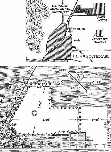
The layout of the original El Paso Municipal Airport (courtesy of Bill Quinn), from the 10/7/28 issue of the El Paso Evening Post.
The El Paso Municipal Airport was originally located in a different location than the present-day El Paso International Airport.
A considerable amount of information about the original El Paso Municipal Airport was submitted by William Quinn,
who extracted it from the El Paso International Airport's publication entitled "50 Years of Service".
The first El Paso Municipal Airport was dedicated in 1928, on a plot of land adjacent to the west side of the Army's Biggs Field.
It had an unpaved all-way landing area measuring 3,150' x 2,750',
with a single 60' x 100' steel hangar along the southeast corner of the field.
Arthur Johnson, a former Army flier, was the first manager of the airport.
Amelia Earhart became the first woman flyer to land at the new field, within its first year.
Also within 1928, the first commercial tenant at the new airport was Scenic Aiways (based in Chicago).
Scenic Airways ceased operations by 1930, and was renamed R & L Airways.
The first regularly scheduled airline service from the original El Paso Municipal Airport was initiated in 1929 by Standard Airlines.
Standard Airlines and the TX & Pacific Railroad inaugurated the country's first rail-plane, coast-to-coast service.
The 1929 Rand McNally Standard Map of TX (courtesy of Chris Kennedy)
depicted 3 airfields in El Paso (from west to east): “Biggs Field”, “Airport Three Sixty Five”, and the “El Paso Airport”.
It described the El Paso Airport as being 200 acres in size.
By 1929, only one year after the Municipal Airport had opened,
Standard Airlines decided it had outgrown the field, and established Standard Airport to the southeast
(which would eventually become El Paso International Airport).
The first airmail service for El Paso was provided in 1930 by Southern Air Fast Express (later a division of American Airlines),
with the inaugural flight being conducted through El Paso Municipal Airport.
However, all future airmail flights were conducted at Standard Airport.
By 1930, activities at El Paso Municipal Airport consisted of private aircraft, charter aircraft, and a flying school.
The location & layout of the El Paso Municipal Airport, as depicted on the 9/13/30 Department of Commerce Airway Bulletin (courtesy of Jonathan Westerling).
It described El Paso as being owned & operated by the City of El Paso, and consisting of a 316-acre irregularly-shaped hard field.
Hangars were located on the southwest corner of the field.
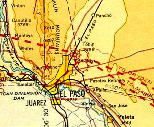
The 1932 Air Navigation Map #30 (courtesy of Bill Johnston) depicted the El Paso Airport as one of 3 airfields in close proximity.
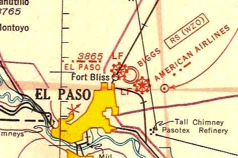
El Paso Municipal Airport, as depicted on the 1935 Roswell Sectional Chart.
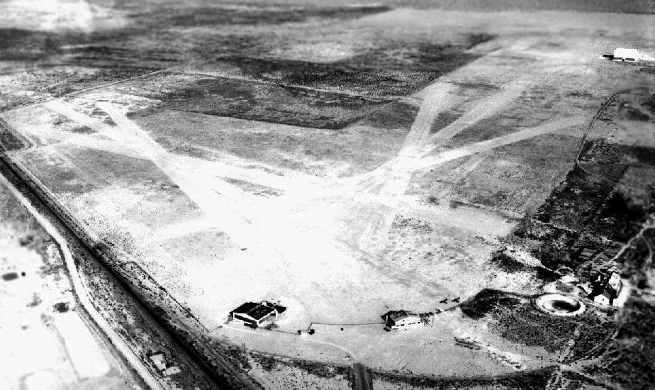
A 1936 aerial photo looking northeast at the original El Paso Municipal Airport (courtesy of Bill Quinn).
The 2 hangars of El Paso Municipal Airport are at the bottom-center, and the dirigible hangar of Biggs AAF is at the top-right.
A total of 6 unpaved runways were visible on the airfield's landing area.
American Airlines & the City of El Paso traded airports in 1936,
and in 1938 two hangars were moved from the original Municipal Airport to the new El Paso City Airport.
The original El Paso Municipal Airport was no longer depicted at all (not even as an abandoned airfield)
on the on the April 1938 El Paso Sectional Chart or the 1939 USGS topo map.
The site of the original El Paso Municipal Airport was not recognizable as a former airfield on a 1946 aerial photo.
A clue as to the previous occupant of the property is found on USGS topo maps from 1983 & 1997, which still labeled the area as "Planeport".
According to Bill Quinn, "It was just vacant land for many years, when around 2000 it became a concrete batching plant & railhead for Jobe Concrete Products."

A 2002 USGS aerial photo of the site of the original El Paso Municipal Airport.
The circular tank of the El Paso city waterworks at the bottom-center is the same one visible in the above 1936 aerial photo.
But there does not appear to be any trace remaining of the former airfield at the site.
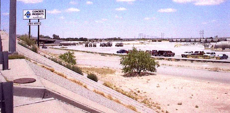

Two 2002 photos by Bill Quinn of the site of the former El Paso Municipal Airport, now the "Planeport" plant of Jobe Concrete Products.
The site of the original El Paso Municipal Airport is located northeast of the intersection of Railroad Drive & Fred Wilson Road,
adjacent to the west side of Biggs Army Airfield.
___________________________________________________
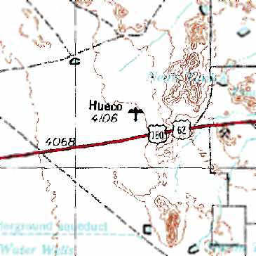
Hueco Airport (4E8), El Paso, TX
31.84, -106.13 (East of El Paso, TX)
Hueco Airport, as depicted on the August 1971 El Paso Sectional Chart.
Photo of the airfield while operational has not been located.
This private airfield was evidently established at some point between 1968-71,
as it was not yet depicted on the February 1968 El Paso Sectional Chart.
Hueco Airport was originally intended to be used as a private airstrip for John Barnett's plane.
In 1968, after attending several auto races in Mexico, Barnett got the idea to operate a racetrack on the airport site.
The first race at the "El Paso Dragway" was held in 1969, and for the next several years the airport was apparently simultaneously used as a racetrack.
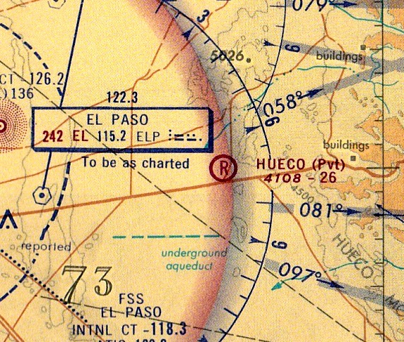
The earliest depiction which has been located of the Hueco Airport was on the August 1971 El Paso Sectional Chart.
It depicted Hueco as a private airfield with a 2,600' unpaved runway.
Hueco Airport, as depicted on the 1974 USGS topo map.
Hueco Airport was listed as a private airfield in the 1982 AOPA Airport Directory (courtesy of Ed Drury),
which described the field as consisting of a 2,600' asphalt Runway 18/36 & a 2,500' dirt Runway 9/27.

The last aeronautical chart depiction which has been located of Hueco Airport was on the August 1985 El Paso Sectional Chart,
which depicted Hueco as a private airfield having a 2,600' unpaved runway.
Hueco Airport was evidently closed as an airfield at some point between 1985-93,
as it was no longer depicted on the August 1993 El Paso Sectional Chart,
and the 1995 USGS topo map labeled the site only as "Drag Strip".
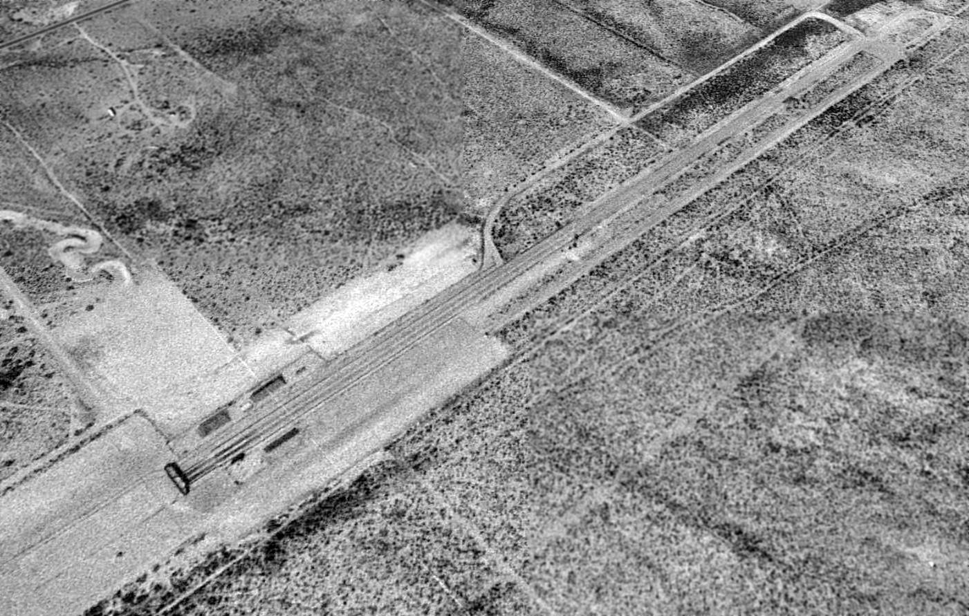
As seen in a 2/10/96 USGS aerial view looking northwest at Hueco Airport, the former Runway 18/36 (which had been reused as the drag strip) had been lengthened to 3,600',
but there was no trace remaining of the former Runway 9/27.
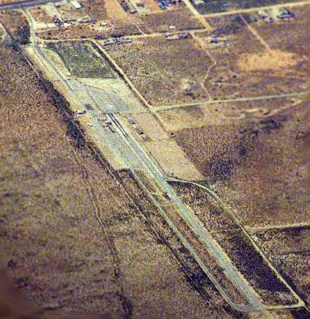
A 2003 photo looking southwest from 16,000 feet at the former Hueco Airport, by Bill Suffa.

A 2013 photo looking north at the Thunder Alley Dragway entrance gate, toward the Hueco Airport site.
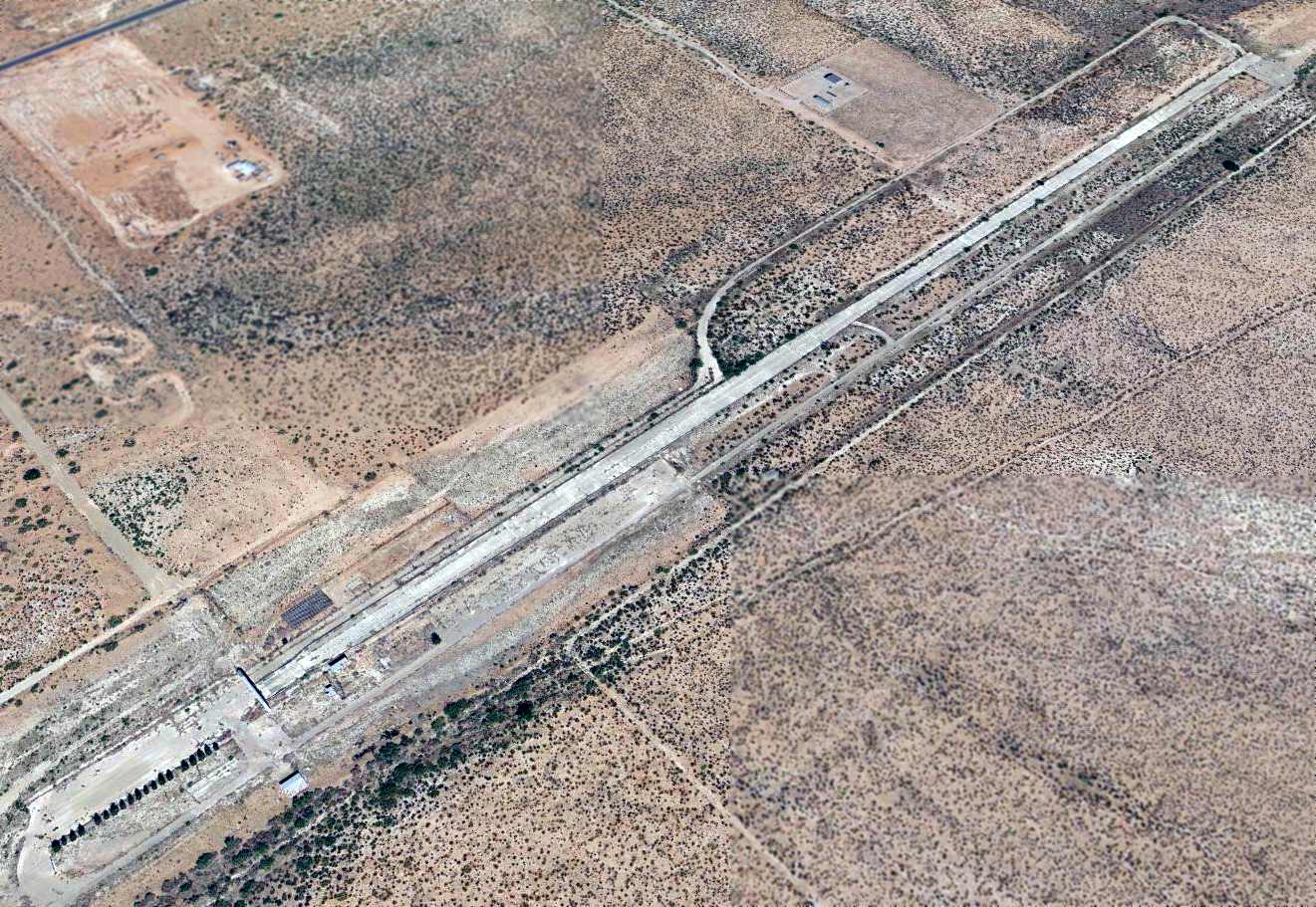
A 2014 aerial view looking northwest at the former Hueco Airport.
The site of Hueco Airport is located north of Route 62, 8 miles east of Route 375.
____________________________________________________
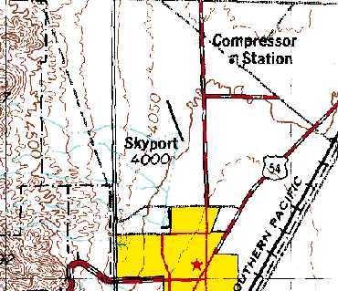
Skyport Airport (4E7), El Paso, TX
31.95, -106.42 (North of El Paso, TX)
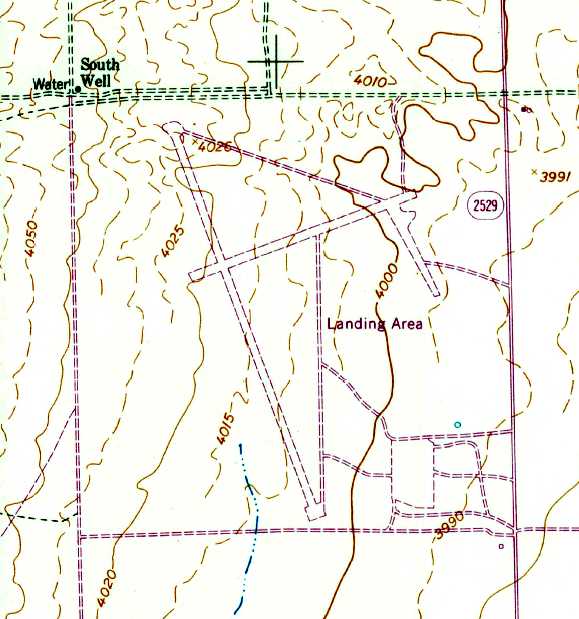
Skyport Airport, as depicted on the 1955 USGS topo map.
Photo of the airfield while operational has not been located.
This small general aviation airport was evidently constructed at some point between 1946-55,
as it was not yet depicted on a 1946 aerial photo.
The earliest depiction which has been located of Skyport Airport was on the 1955 USGS topo map.
It depicted 2 perpendicular runways & 2 taxiways, labeled simply as “Landing Area”.
Skyport was not listed among active airfields in the 1962 AOPA Airport Directory.
The earliest airport directory listing which has been located of Skyport Airport was in the 1963 TX Airport Directory.
It was described as having a 5,000' “sod” runway,
along with the remark, "Private, restricted to skydiving & soaring only."
The manager was listed as Skydivers of El Paso, Inc.
Skyport was not depicted on the 1965 El Paso Sectional Chart.
Steve Wood recalled, “Skyport Airport... In 1965-66 I was an Army Aviator stationed at Biggs Army Airfield.
Ft. Bliss had a skydiving team who used this field for their skydiving activities.
I often flew the skydivers to this airport for their jumps from a De Havilland U-6 Beaver.
At that time, there were no facilities or buildings on the site.
The field was also used for glider towing & launching.
I don't know who maintained the dirt runways but they were in good condition.”
The 1967 AOPA Airport Directory (courtesy of Jonathan Westerling)
described Skyport as “Private airstrip closed to Public.
Used by Skydivers of El Paso. Visiting skydivers welcome.”
It was said to have 2 dirt runways: 5,090' Runway 15/33 & 2,950' Runway 6/24.
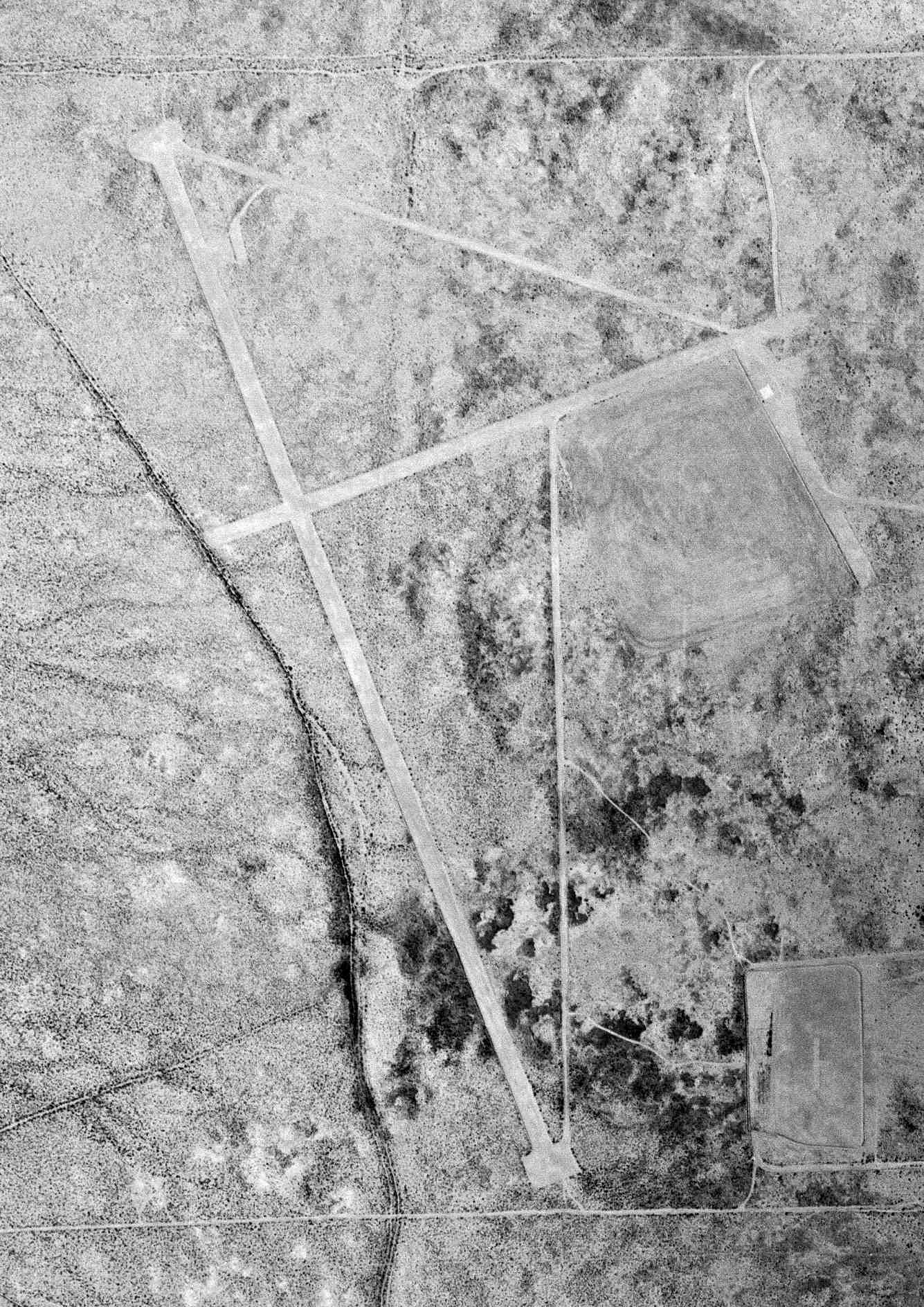
The earliest photo which is available of Skyport Airport was a 3/16/67 USGS aerial view.
It depicted 2 unpaved runways, with a ramp on the south end, but there were no buildings or aircraft.
Skyport was not depicted on the August 1971 El Paso Sectional Chart.
Skyport Airport, as depicted on the 1974 USGS topo map.
The earliest aeronautical chart depiction which has been located of Skyport was on the 1977 El Paso Sectional Chart.
It depicted Skyport as a private airfield with a 5,000' unpaved runway.
The 1979 AOPA Airport Directory (courtesy of Jonathan Westerling)
described Skyport as “Private. Closed to public. Parachuting activities reported.”
It was said to have 2 dirt runways: 5,000' Runway 15/33 & 3,000' Runway 6/24.
Skyport Airport was listed as a private airfield in the 1982 AOPA Airport Directory (courtesy of Ed Drury),
which described the field as consisting of a 5,000' dirt Runway 15/33 & a 3,000' dirt Runway 6/24.
Skyport may have been closed by 1983, as the 1983 USGS topo maps label the field simply "Landing Strips".

The last aeronautical chart depiction which has been located of Skyport was on the August 1985 El Paso Sectional Chart.
It depicted Skyport as a private airfield with a 5,000' unpaved runway.
Don Tedrow recalled of, "Skyport... was used occasionally for skydiving up until about 1987.
Sometime around 1986 or 1987, I landed there with a friend in a Citabria, on a weekend when the jump club was using it.
As you can see in the photos, there was some sort of ditch dug across the main Runway 15/33.
I don't know the purpose, most likely a pipeline of some sort. It left a pretty severe dip & bump in the runway."
Skyport was no longer depicted on the August 1993 El Paso Sectional Chart.
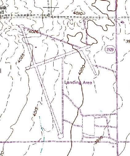
The 1995 USGS topo map depicted the 2 runways & several taxiways, labeled simply as "Landing Area".
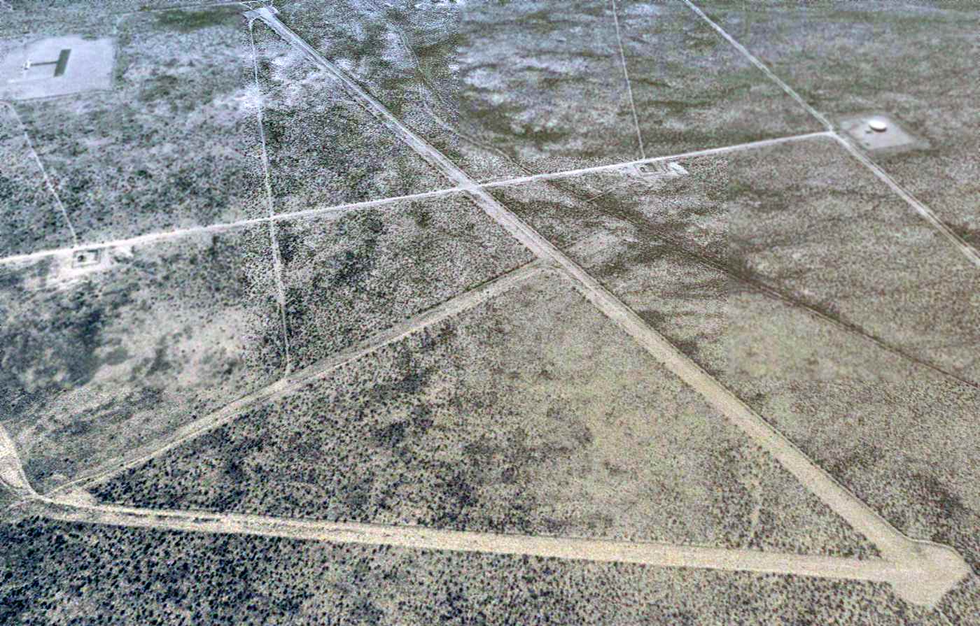
The earliest photo which is available of Skyport Airport was a 1996 USGS aerial view looking south.
It showed Skyport's 2 runways & connecting taxiway still existed in good condition.
According to Don Tedrow, "The structure(s) at the [southeast, the top-left of photo] are the runways & shelter for an El Paso radio control aircraft club.
So in a sense, the 'airfield' is still in use!"
A circa 2006 aerial view looking south at 2 of the runways of the former Skyport Airport.
David Patterson noted in 2006, “Within 5-10 years,
the entire area around the landing strip will be covered with new homes & businesses.”
A 2007 photo by Jonathan Westerling of the shelter of the Burnett Model Air Park adjacent to the southeast side of the former Skyport Airport.
A 2007 photo by Jonathan Westerling, “Looking north up the longer runway at El Paso Skyport.”
Jonathan reported, “It is really amazing how fast they are building houses down there.
In a year & a half the encroaching developments have chewed up a half mile of desert
and now come all the way up to the west end of the former Skyport runway.
As an aside, this DID make it much easier to drive right up to the site for photos without having to bushwhack through the sagebrush,
so there is a small a silver lining I suppose.
The runway & taxiways are hard packed soil with grass growing up along their length.
I was unable to find any remnants of other aviation infrastructure on site.”
A 2008 aerial view showed the Burnett Model Air Park adjacent to the southeast side of the Skyport Airport site appeared to remain in use.
A 2010 aerial view showed that trenches had been cut across the model-aircraft runway of the Burnett Model Air Park adjacent to the southeast side of the Skyport Airport site,
bringing to an end the last aviation usage of this property.
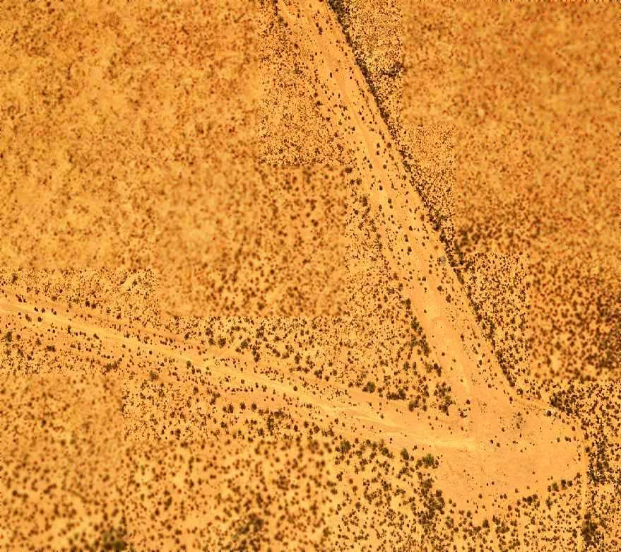
A 2014 aerial view looking south showed the site of Skyport Airport remained intact, without any redevelopment.
It showed Skyport's 2 runways & connecting taxiway still existed in good condition.
____________________________________________________
MacGuire Ranch Airfield, El Paso, TX
31.53, -105.73 (Southeast of El Paso, TX)

The MacGuire Ranch Airfield, as depicted on the March 1960 El Paso Sectional Chart.
The date of construction of the MacGuire Ranch Airfield has not been determined.
According to an obituary on the website of the War Eagles Air Museum (courtesy of Don Tedrow),
this was the private airfield of John MacGuire, a rancher & devoted pilot.
MacGuire moved to the El Paso area in 1947, and he kept many of his warbirds at his private airfield.
MacGuire Ranch Airfield was not yet depicted on the March 1959 El Paso Sectional Chart.
The only aeronautical chart depiction of the MacGuire Ranch Airfield which has been located was on the March 1960 El Paso Sectional Chart,
which depicted MacGuire Ranch Airfield as having a 5,000' unpaved runway.
MacGuire Ranch Airfield was not depicted on the 1965 El Paso Sectional Chart.
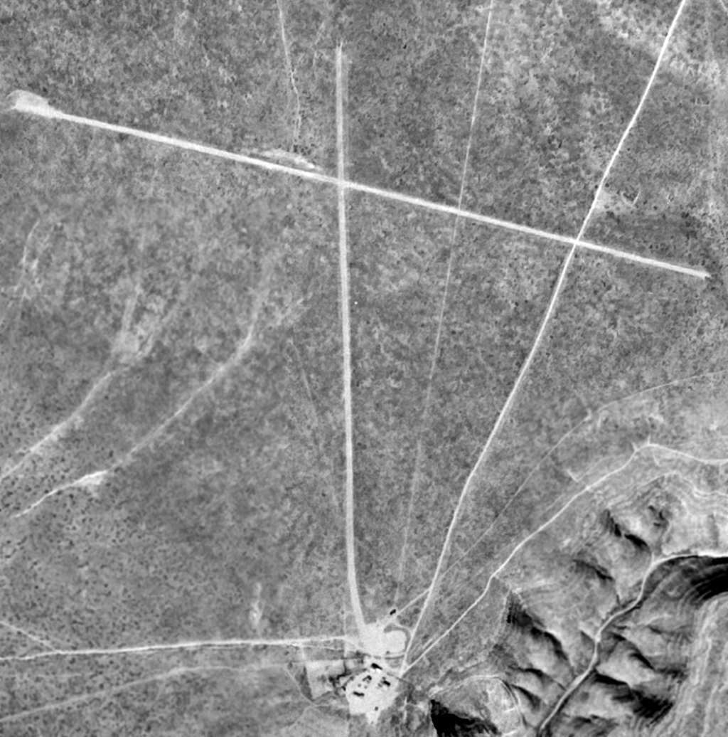
The earliest photo of the MacGuire Ranch Airfield which has been located was on a 1/1/74 USGS aerial view.
It depicted MacGuire as having 2 unpaved runways.
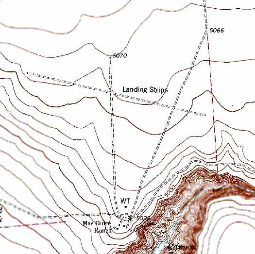
The 1978 USGS topo map depicted MacGuire Ranch Airfield as have 3 runways, labeled simply as “Landing Strips”.
The 1985 USGS topo map continued to depict 3 runways labeled simply as “Landing Strips”.
MacGuire eventually moved his warbird collection after founding the War Eagles Museum at Santa Teresa Airport in 1989.
MacGuire Ranch Airfield was not depicted on the August 1993 El Paso Sectional Chart.
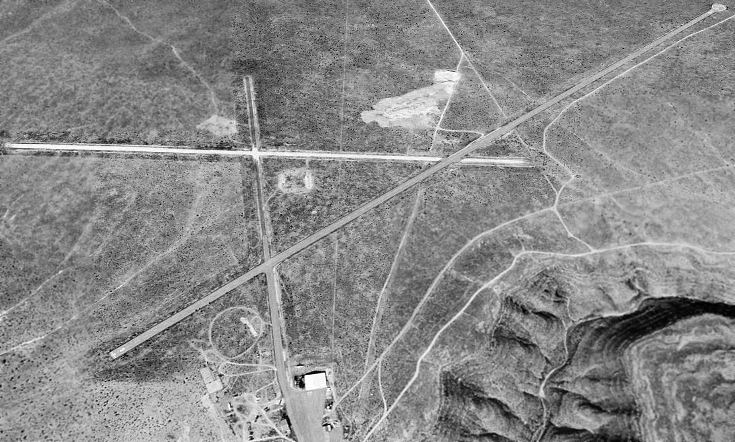
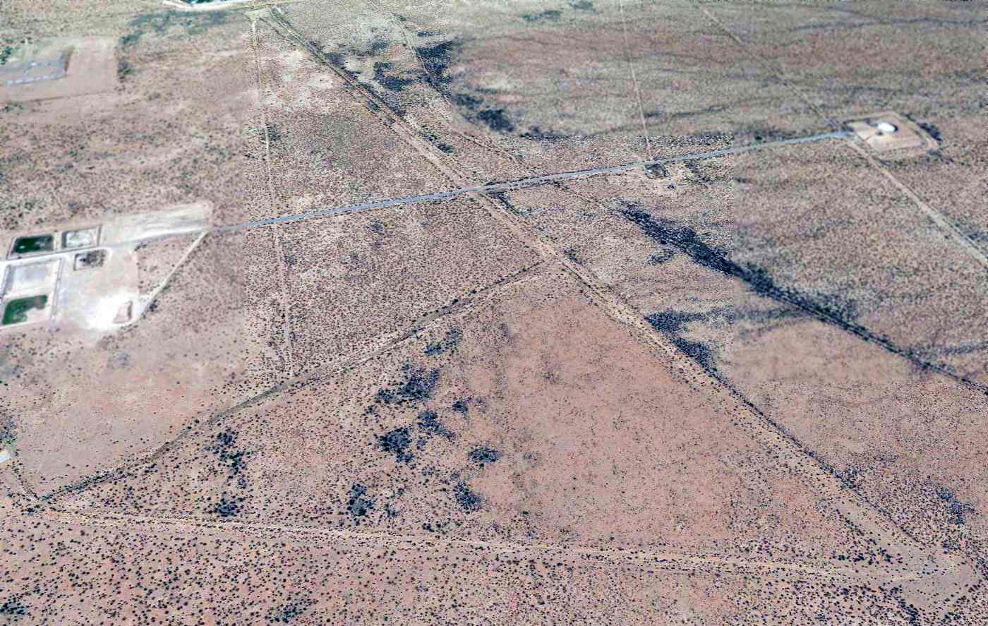
A 1996 USGS aerial view looking northeast showed the MacGuire Ranch Airfield to consist of 3 runways (the longest, 5/23, is 9,200') & a small ramp & hangar on the south side of the field.
The largest runway had been added at some point between 1974-96. The MacGuire's ranch house was also located just to the south of the airfield.
The MacGuire Ranch Airfield appeared to still be active, as the runways were not marked with closed runway symbols.
What appears to be a DC-3 (without outer wings) sat just north of the hangar.
However, the MacGuire Ranch Airfield was depicted as an abandoned airfield on the 1998 World Aeronautical Chart.
Airfield owner John MacGuire died in 2001 at age 80.
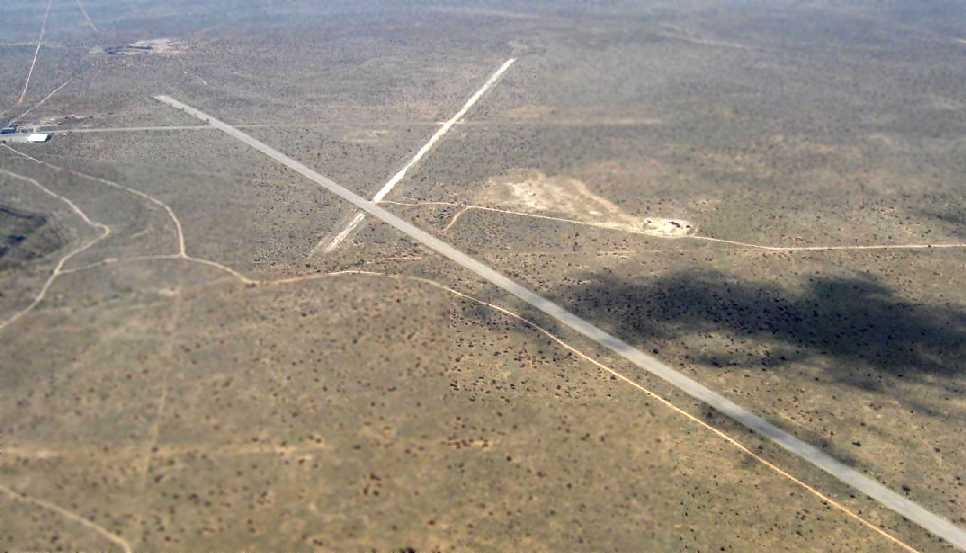
A 3/23/08 aerial view by Marc Ellman looking west at the MacGuire Ranch Airfield.
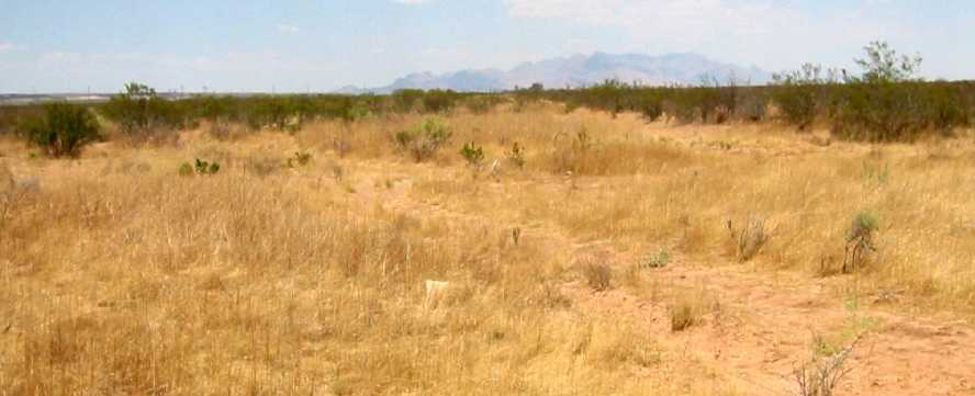
Marc observed, “The runway is still in decent condition. It sits near the edge of a cliff East of El Paso.”
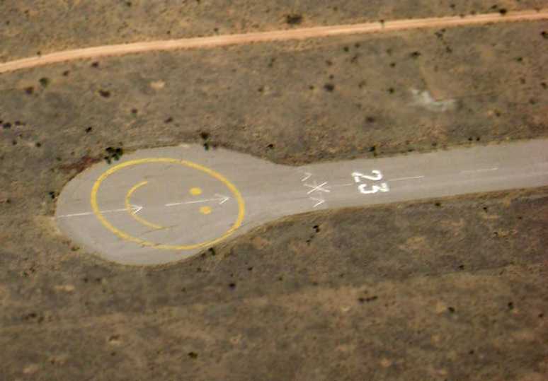
A 3/23/08 aerial view by Marc Ellman looking southeast at the smiley-face painted on the turnaround pad at the end of MacGuire's Runway 23.
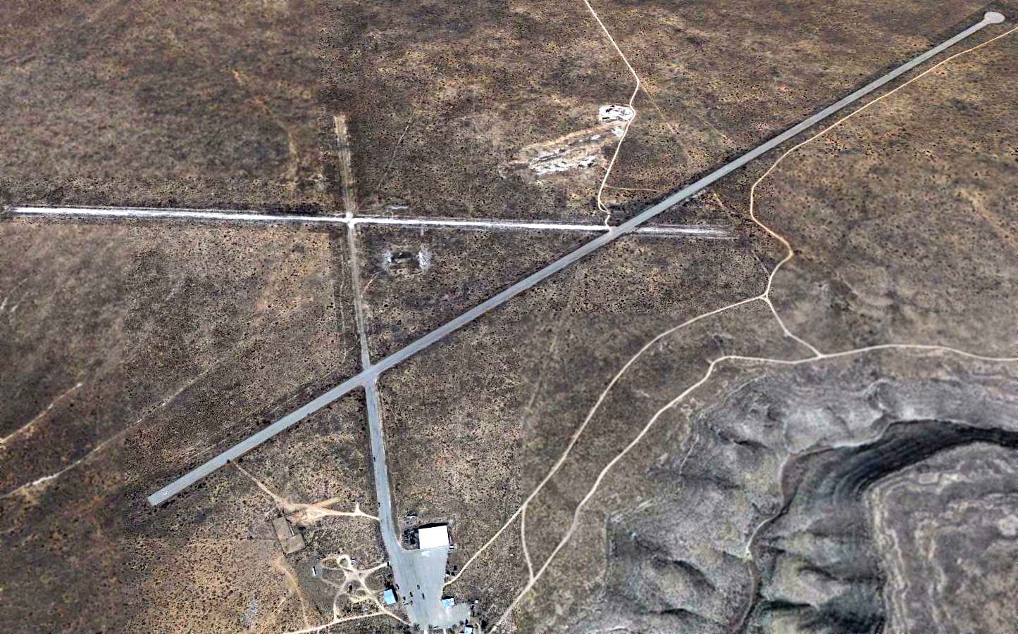
A 2015 aerial view looking northeast shows MacGuire Ranch Airfield as remaining intact. What appears to be a DC-3 (without outer wings) sat just north of the hangar.

A 2023 aerial view of the DC-3 fuselage which remains just north of the MacGuire Ranch Airfield hangar.
____________________________________________________
Or if you prefer to contact me directly concerning a contribution (for a mailing address to send a check),
please contact me at: paulandterryfreeman@gmail.com
If you enjoy this web site, please support it with a financial contribution.
____________________________________________________
This site covers airfields in all 50 states.