Abandoned & Little-Known Airfields:
Texas, Western Houston area
© 2002, © 2026 by Paul Freeman. Revised 6/28/26.
This site covers airfields in all 50 states: Click here for the site's main menu.
____________________________________________________
Please consider a financial contribution to support the continued growth & operation of this site.
Andrau Airpark (revised 6/28/26) - Bay City Municipal Airport (2nd location) (revised 1/23/26) - (Original) Columbus Municipal (revised 7/23/21)
Franz Airfield / King Airfield / King Air Airfield (revised 7/23/21) - Lesikar Ranch Airport (added 4/17/23) - Lite-Flite Ultraport (revised 1/20/23) - Payne Ranch Airport (revised 1/19/25)
Sugar Land State Prison Airfield (revised 12/10/17) - Town & Country Airport (added 1/24/15) - Westheimer Air Park (revised 11/21/18)
____________________________________________________
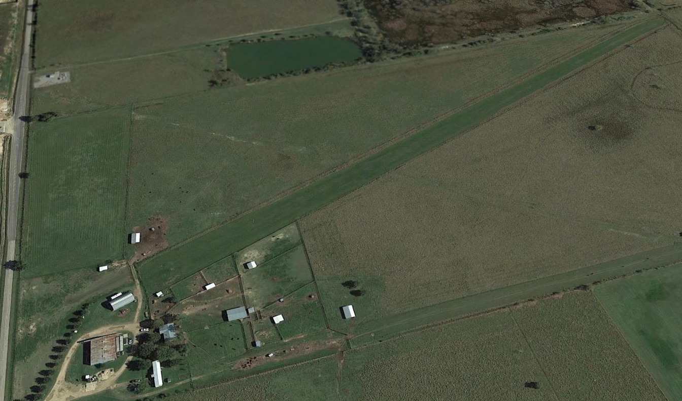
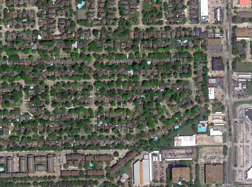
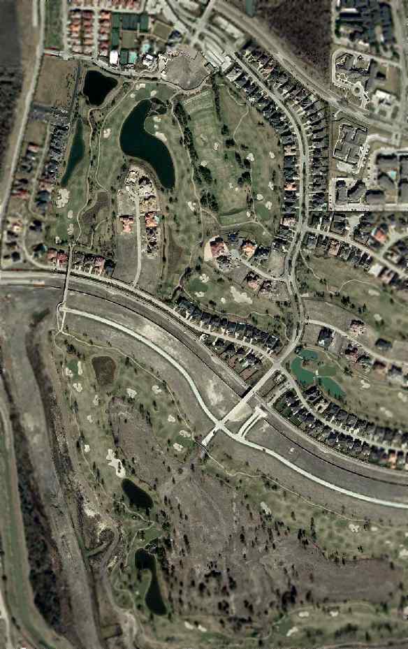
Lesikar Ranch Airport (1TS9, 1T9), Halletsville, TX
29.517, -96.844 (West of Houston, TX)
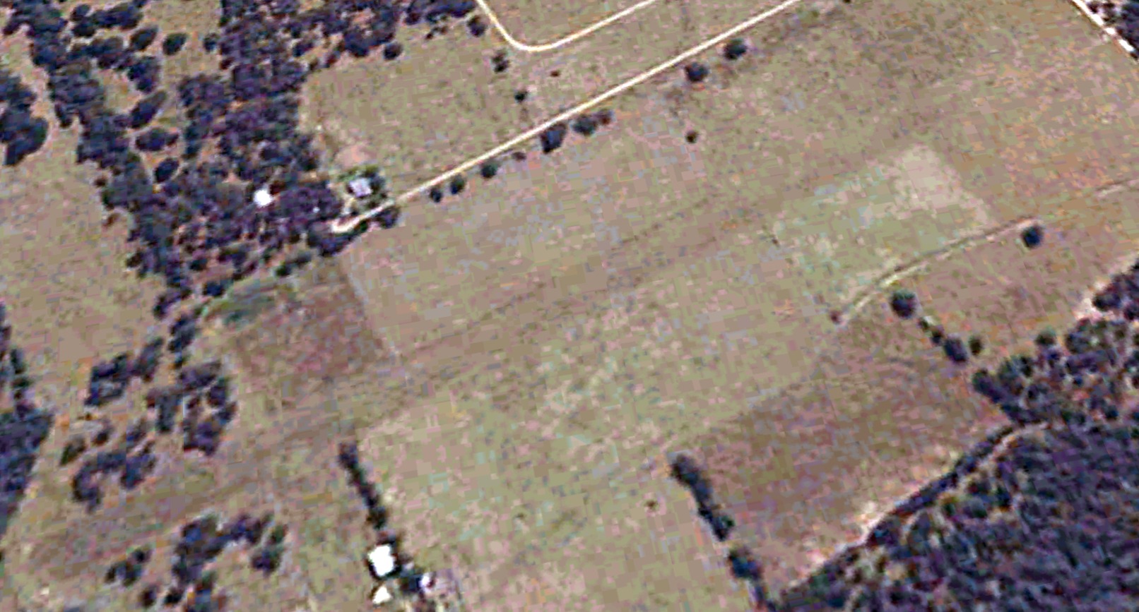
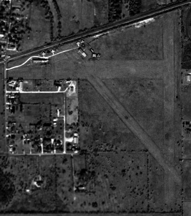
A 2003 aerial view of Lesikar Ranch Airport.
This small private airfield west of Houston was proposed to be established in a 12/21/95 notice (courtesy of Woody Lesikar).
It proposed a single 2,800' turf Runway 16/34, intended to operate 1 single-engine aircraft.
The earliest depiction which has been located of Lesikar Ranch Airport was a 2003 aerial view looking west, which depicted a single unpaved northwest/southeast runway.
An undated aerial view (courtesy of Woody Lesikar) depicted Lesikar Ranch Airport as having a single unpaved runway.
According to owner Woody Lesikar, the Lesikar Ranch Airport “near Hallettsville closed in 2005.”
An undated Sectional Chart (courtesy of Woody Lesikar) depicted Lesikar as a public-use airport having a 2,800' unpaved runway.
Lesikar Ranch Airport was no longer depicted on the 2013 USGS topo map or the September 2018 Houston Sectional Chart.
As of 2020, the FAA Airport/Facility Directory described Lesikar Ranch Airport as “closed indefinitely”.
A 2020 or earlier aerial view of Lesikar Ranch Airport (courtesy of Woody Lesikar).
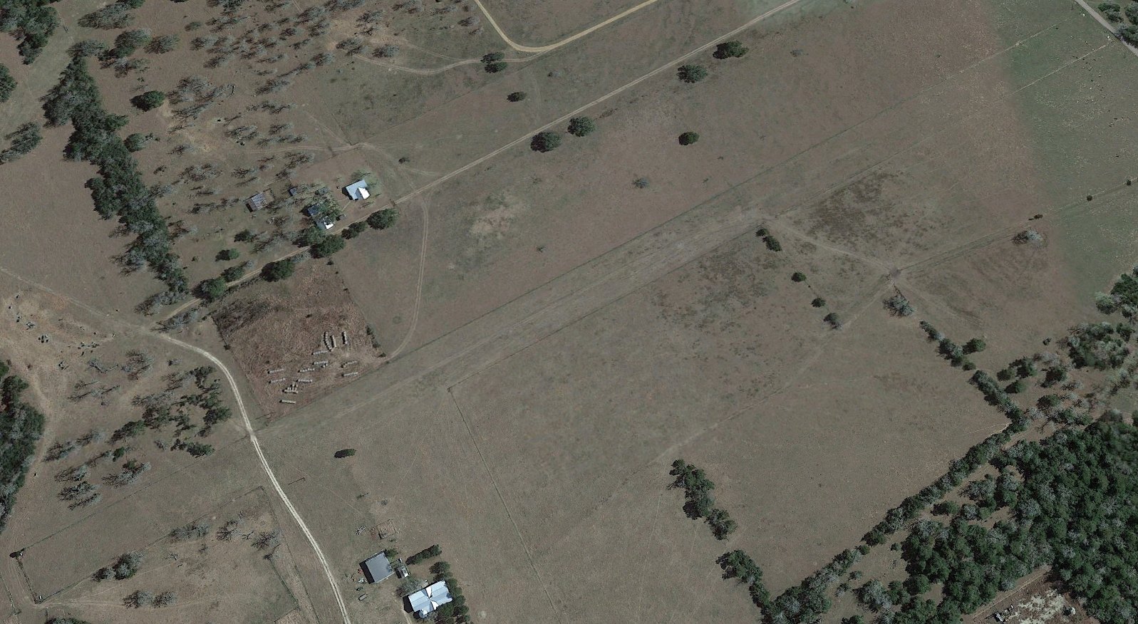
A 2022 aerial view looking west depicted Lesikar Ranch Airport as having a single unpaved northwest/southeast runway.
Thanks to Woody Lesikar for pointing out this airport.
____________________________________________________
29.843, -95.801 (West of Houston, TX)
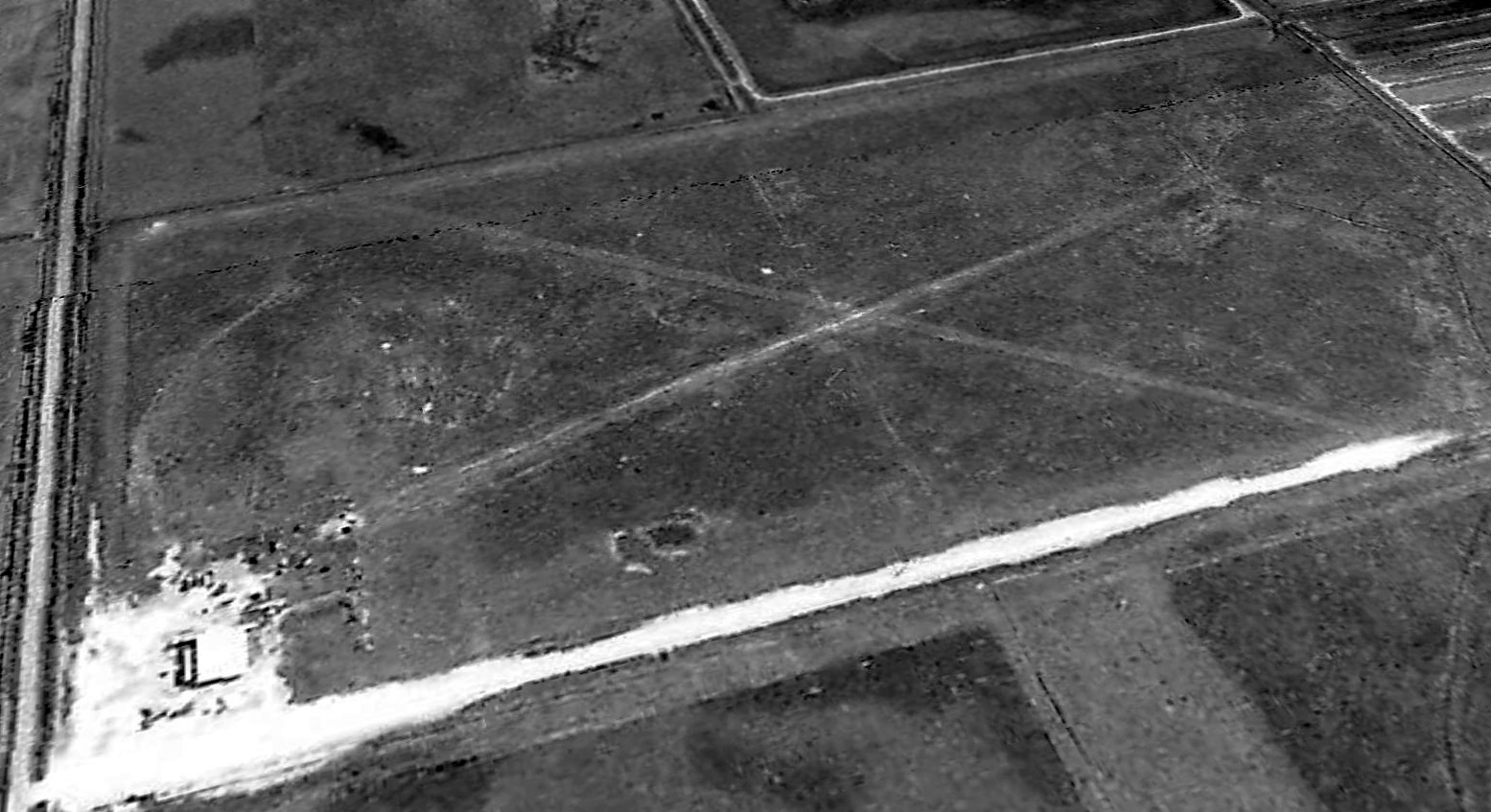
A 1977 TX General Land Office aerial view looking southeast Payne Ranch Airport as having 2 unpaved runways.
This small private airfield west of Houston was evidently established at some point between 1973-77, as it was not yet depicted on a 1973 aerial photo.
The earliest depiction which has been located of Payne Ranch Airport was a 1977 TX General Land Office aerial view.
It depicted Payne Ranch Airport as having 2 unpaved runways, with a small building on the northwest corner.
Payne Ranch Airfield was not depicted on the March 1978 Houston Sectional Chart, the 1980 USGS topo map, or the July 1993 Houston Sectional Chart (courtesy of Ron Plante).
John Rich recalled, “Payne Ranch Airport... Up to 1993-94 this was a crop-duster operation with a turbine Air Tractor,
that served the surrounding rice fields in the Katy prairie, and Skydive West Houston operated there in 1994.
He used to keep an electric fence wire across the runway at night to keep the cattle contained,
and you had to remember to walk down & remove that strand of wire before commencing take-off operations.”
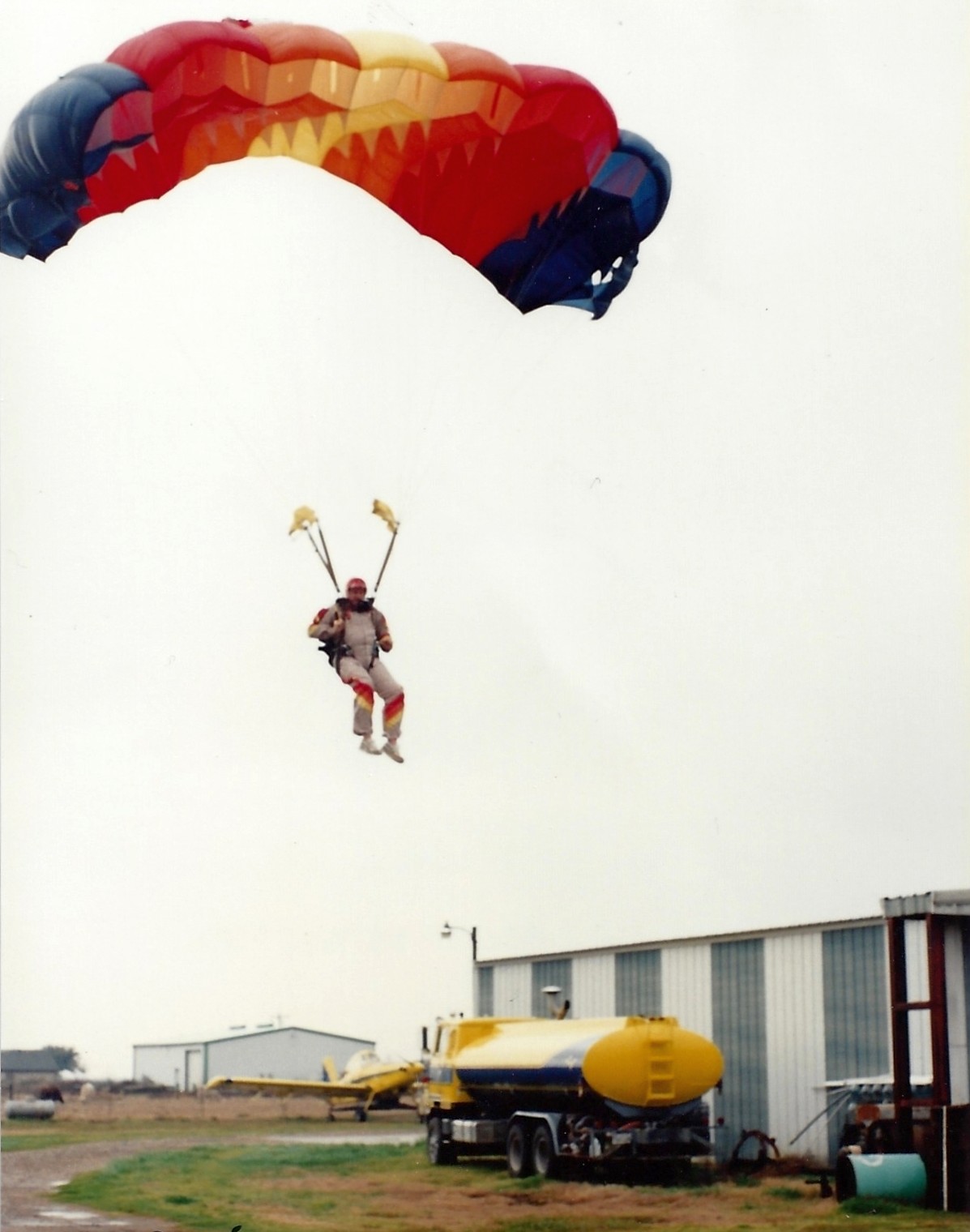
The earliest depiction which has been located of Payne Ranch Airport was a January 1994 photo (courtesy of John Rich) of a skydiver landing,
with a turbine Air Tractor visible in the background.
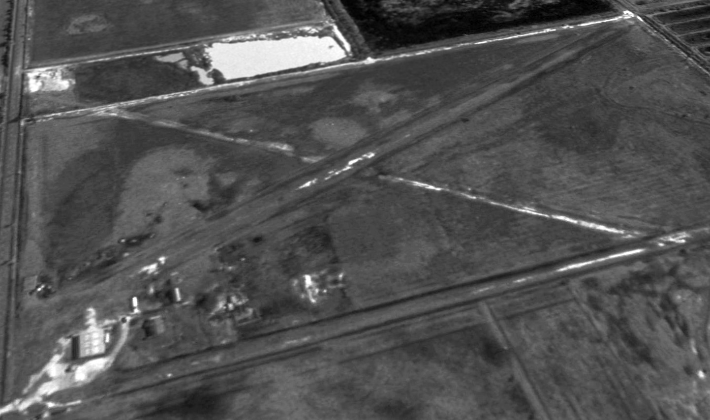
A 1995 USGS aerial view looking southeast depicted Payne Ranch Airport as having 2 unpaved runways, with a few small buildings on the northwest corner.
The only aeronautical chart depiction which has been located of Payne Ranch Airport was on the March 1999 Houston Sectional Chart.
It depicted Payne Ranch Airport as a private airfield having a 2,500' unpaved runway.
Payne Ranch Airport evidently was closed (for reasons unknown) at some point between 1999-2009,
as it was no longer depicted on the March 2009 Houston Terminal Aeronautical Chart.
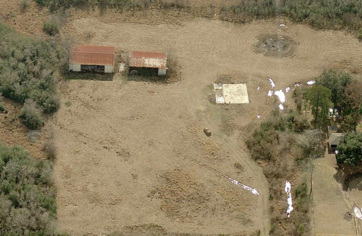
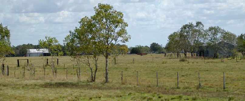
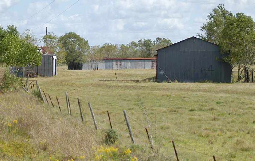
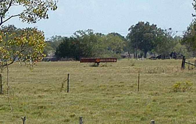
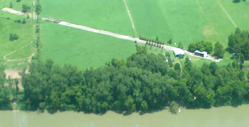
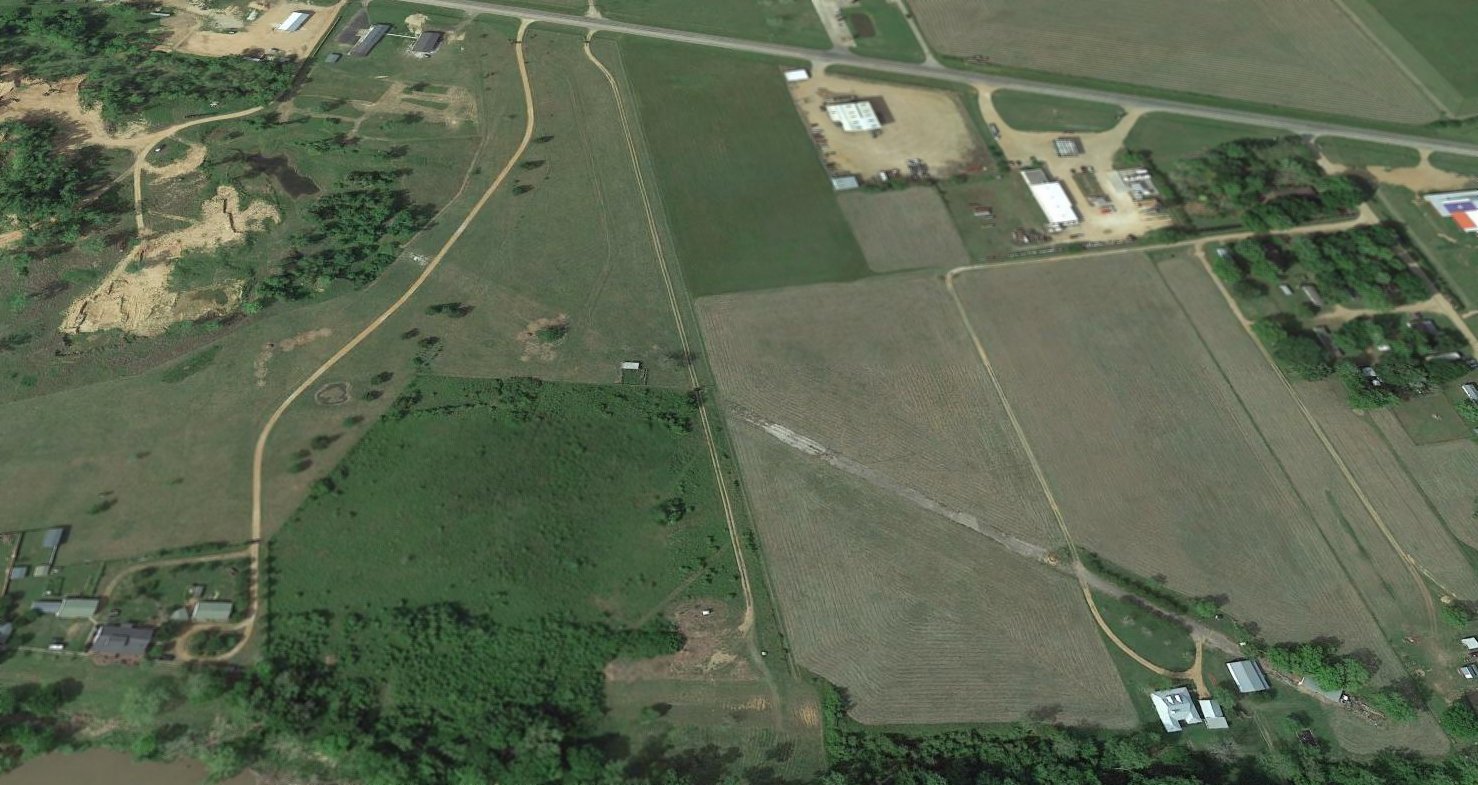
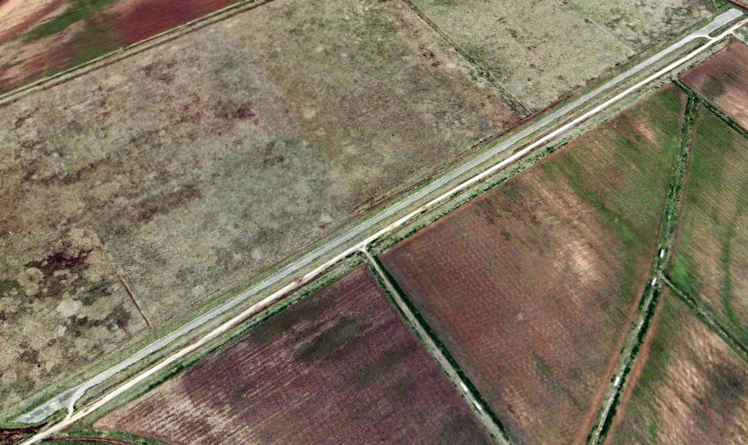
A 2015 aerial view looking southeast showed the 2 former runways of Payne Ranch Airport remained recognizable.

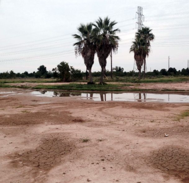
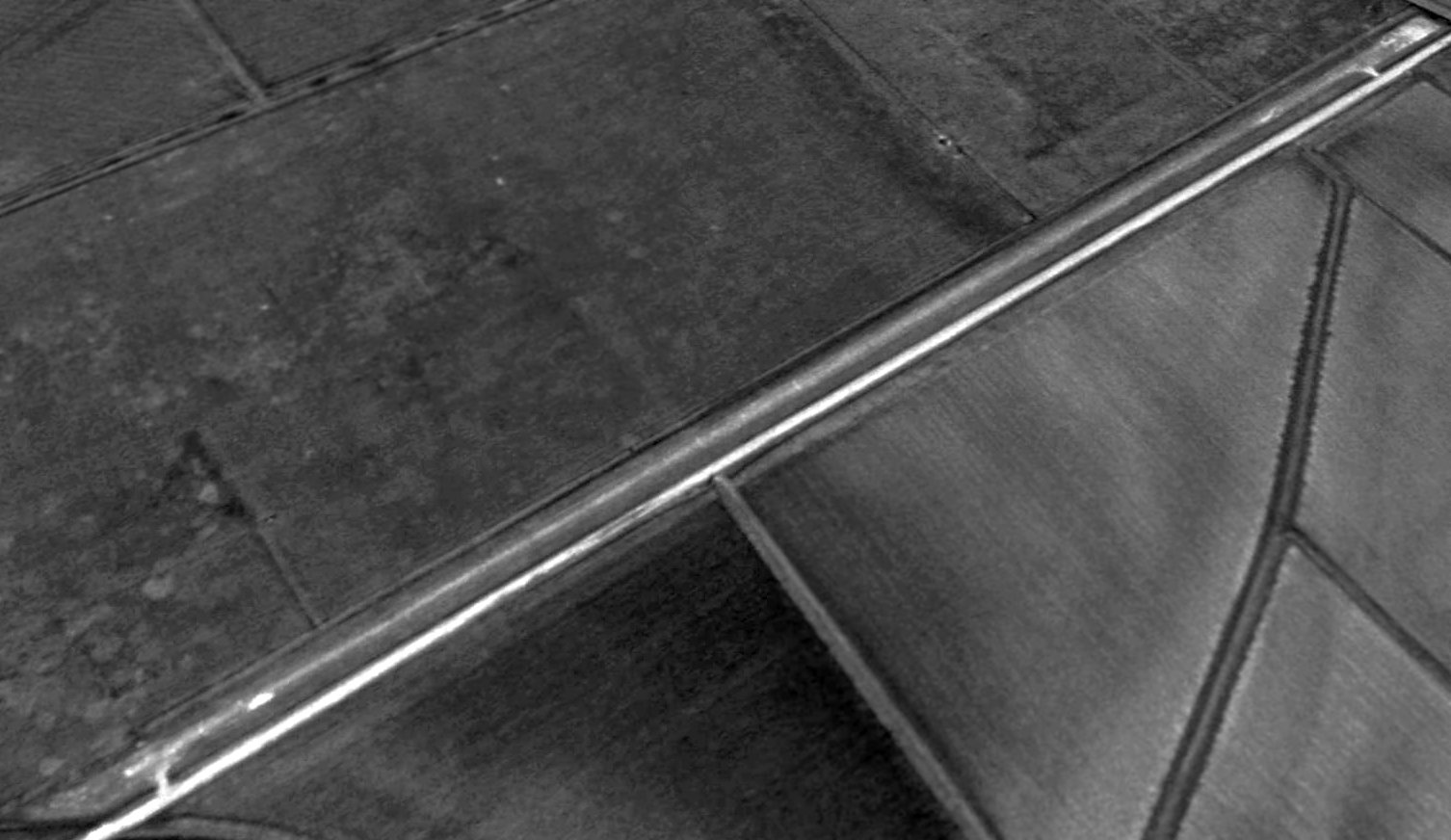
A 2024 photo looking southeast along Payne Ranch Airport's northwest/southeast runway.
As of 2025, street maps label the site of Payne Ranch Airport as “Freeman Property Airport”.
The site of Payne Ranch Airport is located southeast of the intersection of Katy Hockley Cutoff Road & Stockdick School Road.
Thanks to John Rich for pointing out this airport.
____________________________________________________
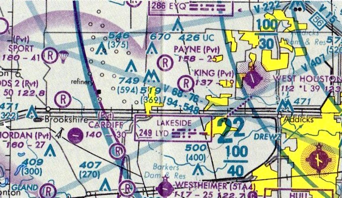
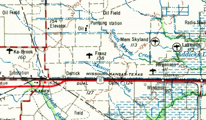
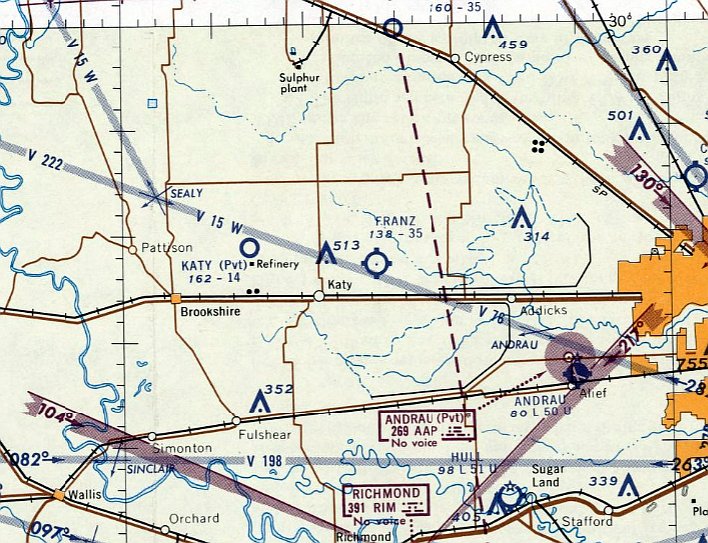
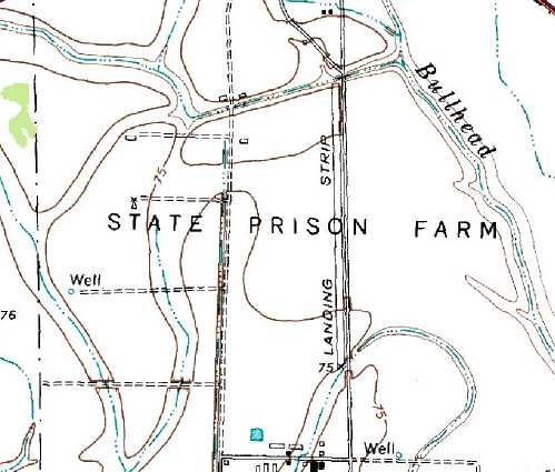
Franz Airfield / King Airfield / King Air Airfield, Katy, TX
29.815, -95.772 (West of Houston, TX)
Franz Airfield, as depicted on the 1956 USGS topo map.
This small private airfield west of Houston was evidently constructed at some point between 1953-56,
as it was not yet depicted on a 1953 aerial photo.
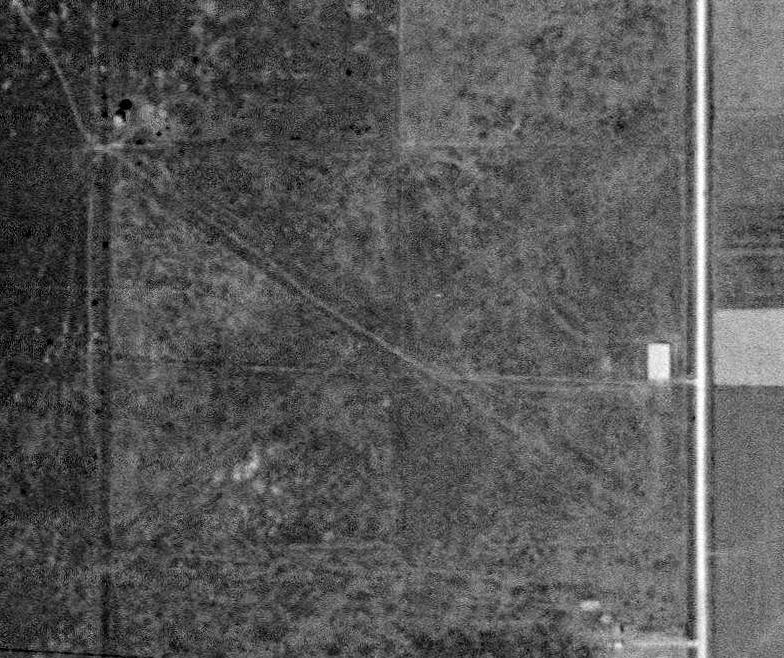
The earliest depiction which has been located of Franz Airfield was on the 1956 USGS topo map.
The earliest photo which has been located of Franz Airfield was a 1958 aerial view.
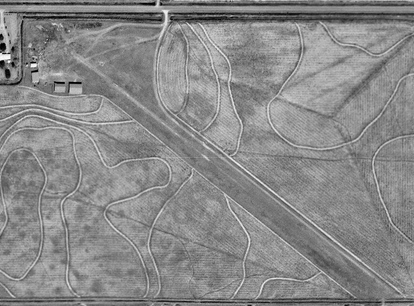
It depicted Franz as having 2 unpaved runways in an X-shape, with a few small buildings & 1 light single-engine aircraft on the northwest side.
Franz Airfield was not yet depicted on the March 1959 San Antonio Sectional Chart.
The earliest aeronautical chart depiction which has been located of Franz Airfield was on the August 1959 San Antonio Sectional Chart,
which depicted Franz as having a 3,500' unpaved runway.
Mike Smith recalled, “King Airfield... In 1964-69 I worked in the summer for Bud & Bertha King & their son Bobby at that airfield.
Bud & Bobby were crop dusters. Bertha & I drove the chemicals out to the planes. His company was called Farm Air Services.”
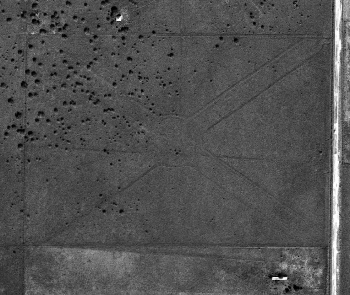
The earliest photo which is available of Franz Airfield was a 1/29/70 USGS aerial view.
It depicted Franz as having a single unpaved northwest/southeast runway.
Two more hangars had been added since the 1958 aerial photo,
but there was no sign of the northeast/southwest runway previously seen in the 1958 photo.
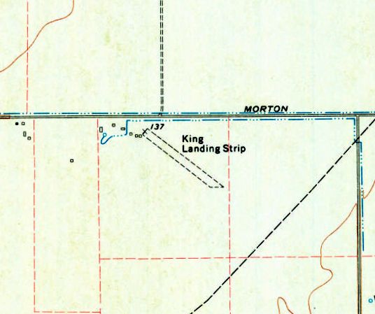
The airport was evidently renamed at some point between 1964-71,
as the 1971 USGS topo map labeled “King Landing Strip” as having a single unpaved northwest/southeast runway.
The last photo which is available of King Airfield was a 12/14/77 USGS aerial view.
The airfield appeared unchanged compared to the 1970 photo.
The 1980 Houston Terminal Aeronautical Chart depicted King Air as a private airfield having a 2,000' unpaved runway.
The last photo which has been located of King Air Airfield was a 1981 aerial view.
The airfield appeared unchanged compared to the 1977 photo,
with 1 light single-engine aircraft parked on the northwest side near the hangars.
A housing development was under construction directly off the southeast end of the runway, though,
presaging the eventual end of this little airfield.
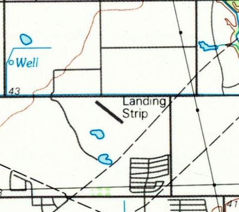
The 1992 USGS topo map depicted King Air Airfield as having 2 single northwest/southeast runway,
but labeled simply as “Landing Strip”, which may indicate the airfield had been closed by that point.
The last aeronautical chart depiction which has been located of King Air Airfield was on the July 1993 Houston Sectional Chart (courtesy of Ron Plante),
which depicted King Air as a private airfield having a 1,900' unpaved runway.
King Air Airfield was evidently closed at some point between 1993-95,
as a 1995 aerial view showed the property remained intact, but the runway appeared overgrown & much less distinct.
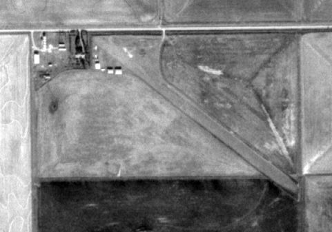
A circa 2010-2011 aerial view looking south at the 2 hangars which remain standing at the site of King Air Airfield.
The King Airfield property (including the former hangars) remained intact on a 2011 aerial photo.
A 2012 aerial photo showed the Grand Parkway had been built right through the center of King Airfield,
but 2 hangars remained standing to the west of the road.
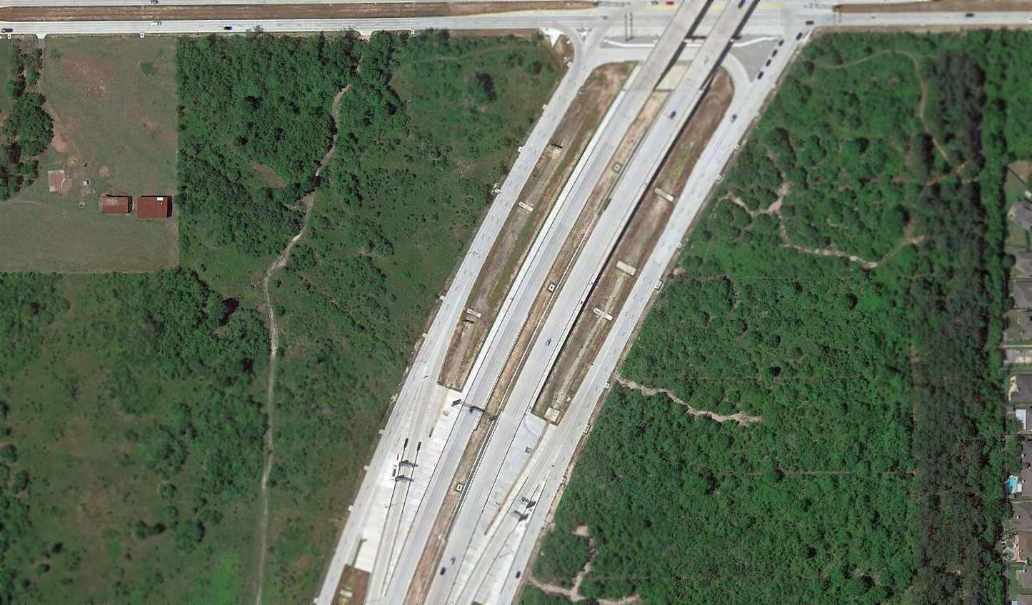
A 2014 aerial view showed the 2 hangars of King Air Airfield remained on the west side, but with Grand Parkway cutting through the center of the airfield site.
According to Danielle White, “Between May 2014 - November 2015, development began on the former airfield & adjacent lots.
On the east side they completely cleared the land & removed a layer of soil for construction of a strip mall with outparcels called Grand Morton Town Center.
On the west side the buildings were removed (along with the house & apparent farm buildings slightly further west) and brush/trees cleared in 2014-15 across much of the lots.
Between February 2017 - April 2019 the western portion was heavily developed.
All that is visible on the April 2019 [aerial photo] is a roughly 400' section of the runway immediately west of TX-99.”
Danielle White reported in 2019, “King Air Airfield... I happened to ride by to find the site changed a lot, with a credit union building near the remaining hangars.
Both are likely to be completely gone very soon if the have not already been paved over.”
Indeed a 2022 photo showed the 2 former King Air Airfield hangars have been removed, erasing the last trace of this little airfield.
The site of King Air Airport is located southeast of the intersection of Route 99 & Morton Ranch Road.
Thanks to Filip Miletic for pointing out this airport.
____________________________________________________
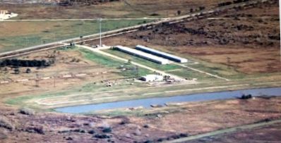
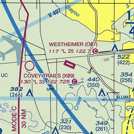
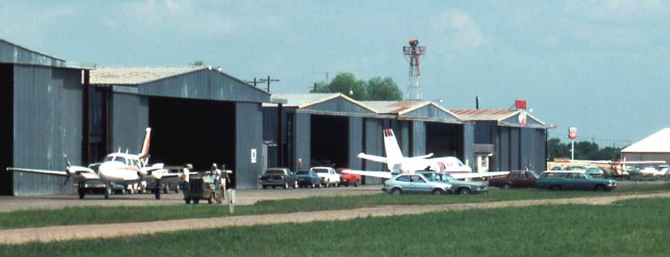
Westheimer Air Park (5TA4 / O07), Richmond, TX
29.695, -95.795 (West of Houston, TX)
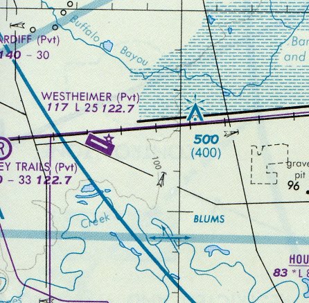
Westheimer Air Park, as depicted on the February 1989 Houston Terminal Chart (courtesy of Stu Sibitzky).
Westheimer Air Park was not yet depicted on a 1976 aerial photo or the 1980 Houston Terminal Chart.
According to its FAA Airport/Facility Directory Data, Westheimer Air Park was established in 4/81.
The earliest photo which has been located of Westheimer Air Park was a 1981 aerial view.
It depicted a single unpaved northwest/southeast runway, along which were parked 9 single-engine aircraft, with a single small building along the north side.
According to Dan Taylor, “During the 1980s oil boom in Houston this airport apparently had aircraft tied down the length of the runway
on the square concrete pads you can see just to the right of the taxiway.”
The earliest depiction which has been located of Westheimer Air Park was on the February 1989 Houston Terminal Chart (courtesy of Stu Sibitzky).
It depicted Westheimer as having a single 2,500' paved northwest/southeast runway.
Scott Schilling recalled, “I flew into Westheimer Airpark once in the early 1990s. There was no development out there, and with pilot controlled lighting it was kind of eerie landing there.
The runway seemed to float in a sea of inky blackness. I don't even remember the power lines paralleling the runway. I guess I survived. I flew in, stood around for a bit, then flew back out.”
The July 1993 Houston Sectional Chart (courtesy of Ron Plante) depicted Westheimer as having a single 2,500' paved northwest/southeast runway.
Cameron Etezadi recalled, “I flew out of Westheimer while I was in college in Houston in the early 1990s.
I started there in 1994 after getting my Private Pilots License elsewhere.
By that point, the runway was already paved & in pretty rough shape, like it had been paved quite a few years prior & not maintained.
It had the cheapest rental rates around, and as a starving college student, it was worth the extra 30 minutes of driving to save $10 or more per hour on a plane.
I used to take a cute girl & a Cessna out to Pierce Field on the Matagorda Peninsula every chance I could get back then;
that airport was totally abandoned, but they had no problems with me taking a flight there!
The FBO at Westheimer had this old Cherokee 140 with a Johnson bar brake.
The best part of coming back into Westheimer Field on a long cross country flight was the TransCo Tower (now called the Williams Tower), one of Houston's tallest buildings,
which had a revolving searchlight on top, and you could see it from miles & miles & miles away as you arrived in the Houston exurbs from the west.”
Cameron continued, “Back in those days, the original identifier was 5TA4.
The runway was super-narrow & I remember a student pilot who drifted off to the side
and got caught up in the high voltage power lines alongside the runway back in the mid-1990s. Fortunately, they were deactivated by then.
Bill Reid, the owner, was a character...one arm which he would use to chain smoke, fly, and flight instruct, all at the same time.
On field, MVP Aviation ran a flight school; John VanPaasschen started it with a few instructors & a few airplanes.
John helped me finish up my instrument rating when I came back to Houston for school one autumn.
Great little airport, and one of my fondest aviation memories! So sad that big development has encroached upon it.”
Tasjah Reid recalled, “Westheimer Airpark… Bill Reid was an EXTRAORDINARY guy with a magnificent dog.”
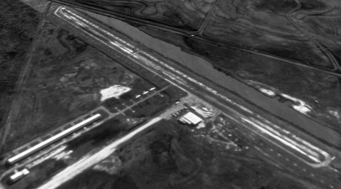
The earliest photo which has been located of Westheimer Air Park was a 1995 USGS aerial view.
It depicted a paved runway & a long row of T-hangars on the north side. Only 6 single-engine aircraft were visible on the field.
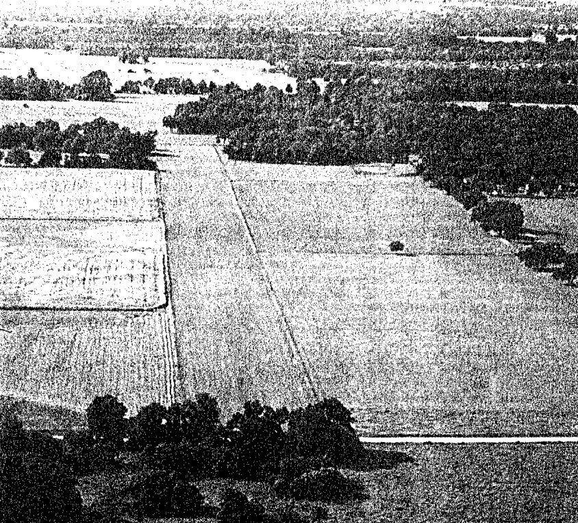
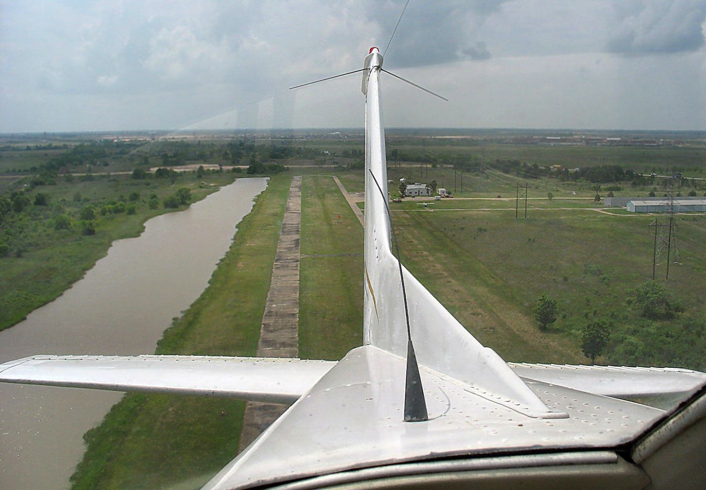
A circa 1996 aerial view by Dan Taylor from final approach to Westheimer Air Park's “Runway 11
which involved clearing the 150' power lines that are visible, contending with the ever-present summertime crosswind on a 28' wide runway
with pond beside you & only 2,500' to stop.
I have heard pilots refer to it as a sidewalk & yes the taxiway certainly was with only a foot or so to spare on either side of the mains on a [Cessna] 172.”
Cameron Etezadi recalled, “The [airport] identifier was changed at some point in the early 2000s to O07.”
A Spring 2000 aerial view by Dan Taylor looking northwest at Westheimer Air Park, “as there is a row of new hangars that were under construction.”
A circa 2001 aerial view by Dan Taylor looking northeast at Westheimer Air Park, showing “the city of Houston encroaching.”
A 5/23/07 aerial view by Steven Wiggs (courtesy of Robin Elston) looking west after departing Westheimer Air Park.
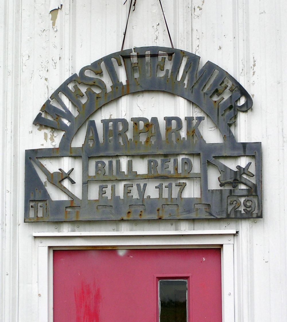
A 12/1/07 photo by Robin Elston of the sign over the entrance to the Westheimer Air Park office.
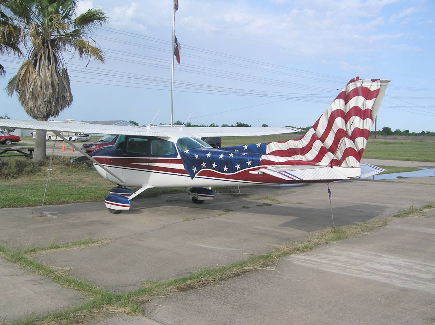
A 2006/2007 photo by Robin Elston of Westheimer Air Park owner Bill Reid's Cessna 172.
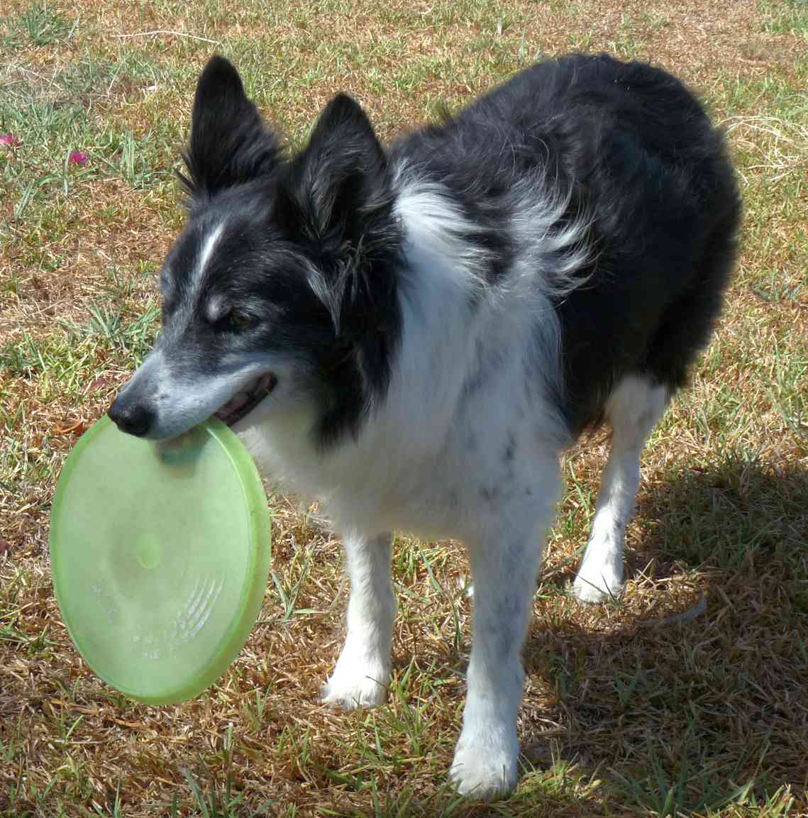
An 8/1/09 photo by Robin Elston of Westheimer Air Park owner Bill Reid's dog, Thrill.
Robin Elston recalled, “The Bill and Thrill show as My Wife & I dubbed it was simply amazing; Bill simply conversed with Thrill.
Bill: 'Do you want to play frisbee?' Thrill charges after & returns with frisbee & expectant gaze.
Bill: 'It's dirty!' Thrill jumps in Bill's truck & returns with a rag.
Bill: 'Too dirty we need a clean frisbee.' Thrill charges up the stairs by the hangar & comes back with a new frisbee.
Bill describes the route he wants Thrill to run to make the catch, and Thrill never missed a beat. I lost track of time entirely watching these two.
I picked up a flyer in his office one day for his concealed handgun license class, I noticed a pistol range south of the west end of the runway that is evident in the [aerial] imagery.
Bill was certainly an interesting character. As it goes with so many people, I wish I had more time to visit. I will miss him & his little airport.”
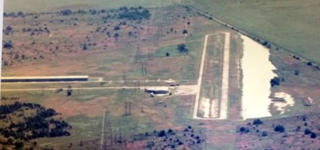
A 2010 aerial view looking north showed that boats significantly outnumbered aircraft at Westheimer Air Park,
which is usually a bad sign for a small airport's long-term viability.
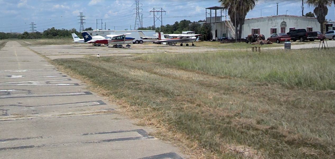
A June 2013 photo by Jeffrey Ng “of O07 when my Dad & I drove to Westheimer Air Park.
The red, white, and blue 172 is Bill's (the owner of the air park) personal plane that he painted with 1 arm!”
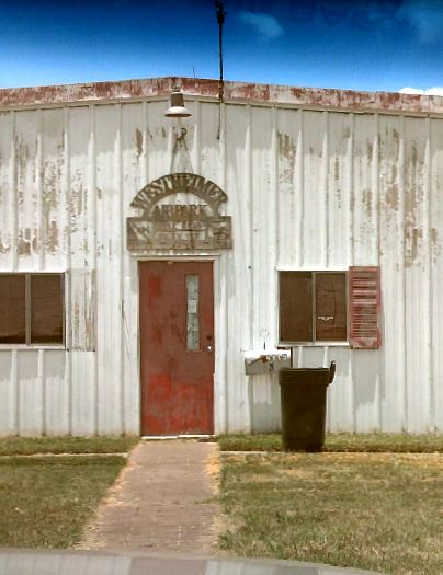
A June 2013 photo by Jeffrey Ng of the Westheimer Air Park office.
John Mechura recalled, “When there was a rare night landing at this airfield the beacon was very visible across FM1093 into my neighborhood.”
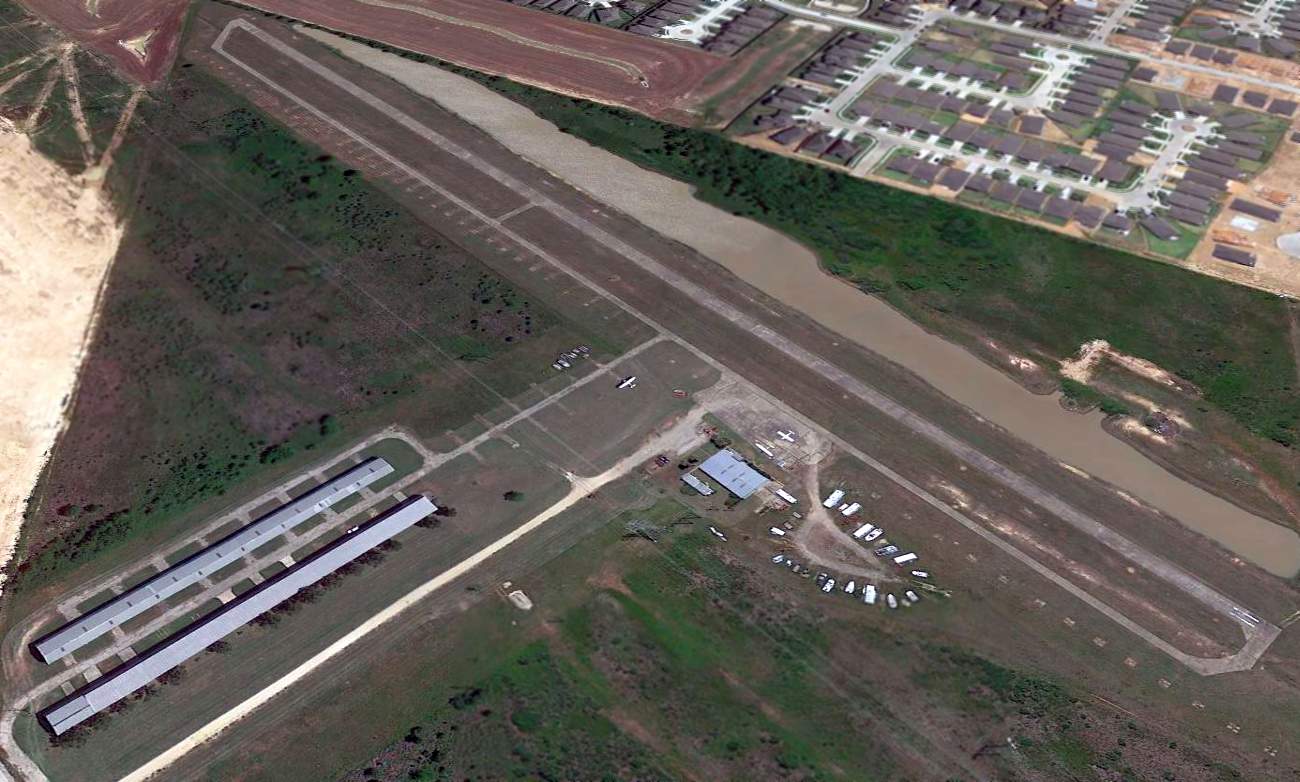
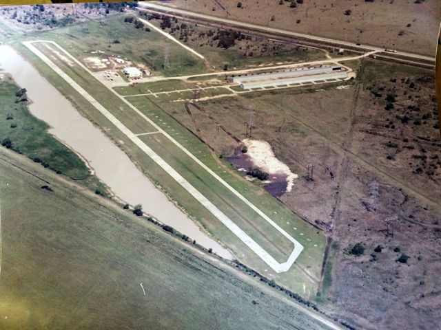
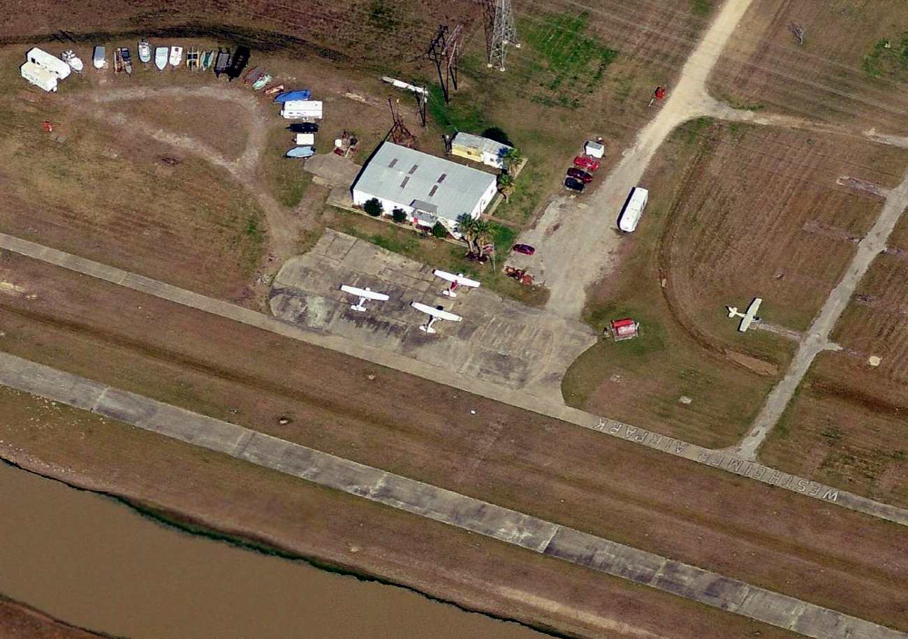
A 2014 aerial view looking southeast at Westheimer Air Park showed only 3 single-engine aircraft on the field.
Nicki Gray reported, “I was the goddaughter of Bill Reid. Bill owned & operated Westheimer Air Park. He passed away Christmas day 2014 & our family inherited the airport.
We were disappointed & sad to see the airport close; that was Bill's entire life, literally. I remember when he bought it & what he made it.
I'm so saddened by the loss of my godfather that I haven't been to the airport site since my mother & I had to spend a month there clearing everything out;
it was a very daunting task that took everything out of me.
I enjoyed reading other's memories of my beloved godfather & his sidekick, Thrill. It brought wonderful thoughts of growing up back but also makes me sad, I miss him very much.”
Dan Taylor recalled, “I was a tenant there for years & am sad to see it go.”
As of 2015, Westheimer Air Park's FAA Airport/Facility Directory Data described it as having a 2,500' concrete Runway 11/29, “in poor condition.”
The owner was listed as Reid Management Company, and the manager was still listed as Bill Reid.
The 2015 Houston Terminal Aeronautical Chart still depicted Westheimer as having a 2,500' paved runway.
Matthew Kosmoski reported in 2015, “O07 has dropped off of the Airport Facility Directory & [aeronautical] charts.
Somebody casually mentioned to me that it officially closed in March 2015.”
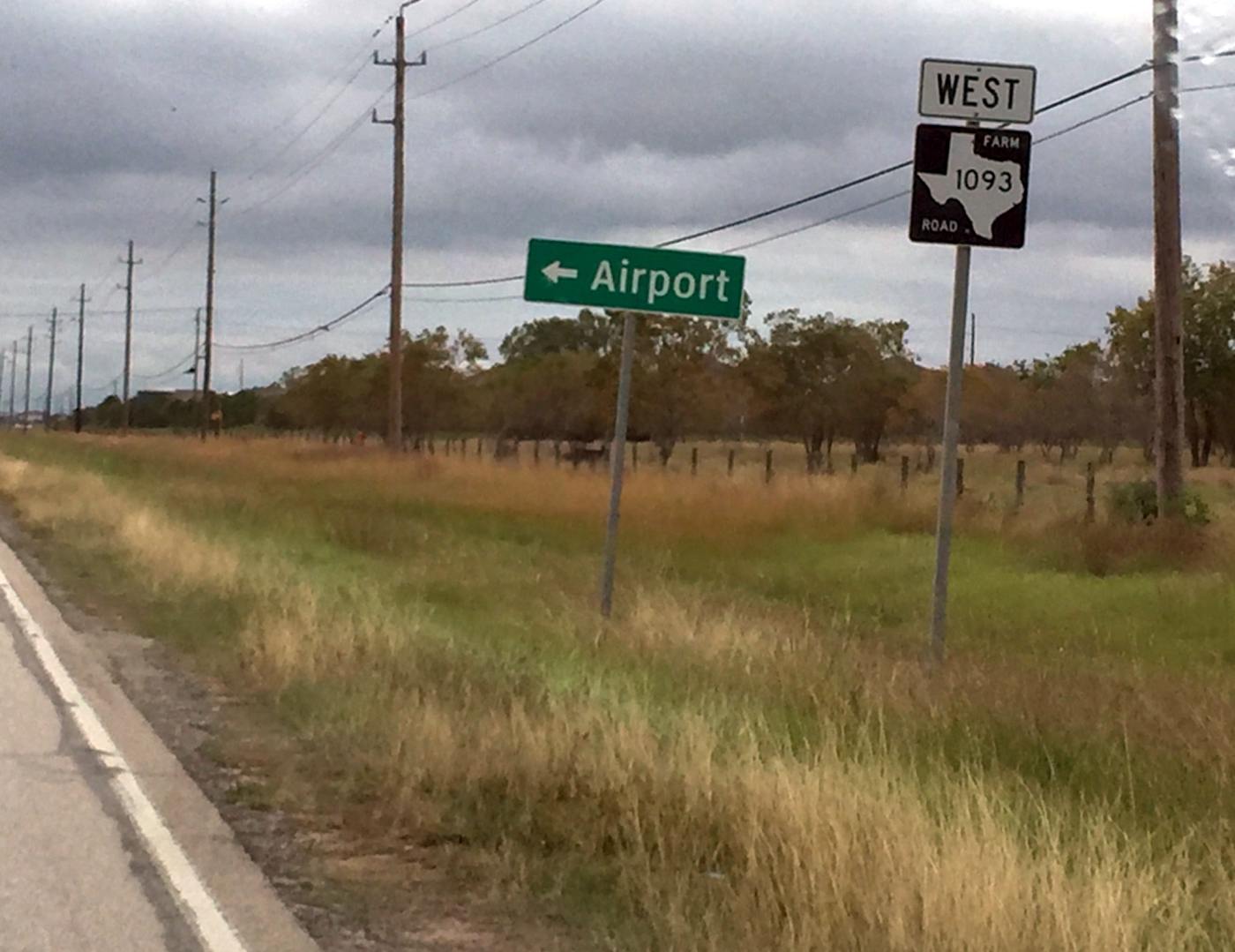
A 10/4/15 photo by John Mechura of the only reminder that remains of Westheimer Airpark: the airport sign, “A sad reminder pointing to where the airport was on FM1093.”
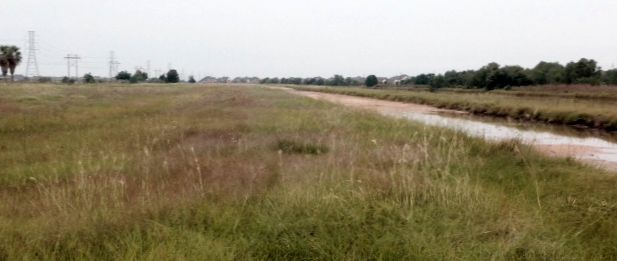
A 10/4/15 photo by John Mechura looking southeast along the former Westheimer Airpark runway.
John observed, “The runway as well as the taxiway have been completely removed.”
A 10/4/15 photo by John Mechura of the Westheimer Airpark Fixed Base Operator site.
John observed, “It as well as the hangars have been removed. They left several of the palm trees for some reason.
The palm trees are clearly visible in some of the [earlier] photos of the airfield.”
Westheimer Air Park was no longer depicted on the 2018 Houston Sectional Chart.
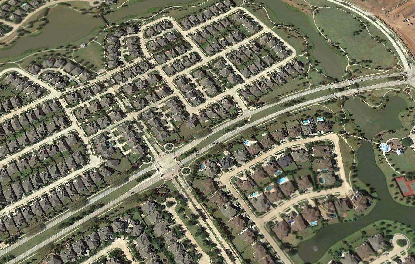
A 2018 aerial view showed no trace remaining of Westheimer Air Park, with a housing development covering the site.
The site of Westheimer Air Park is located southwest of the intersection of Route 1093 & Katy Gaston Road.
Thanks to Dan Taylor for pointing out this airport.
____________________________________________________
Town & Country Airport, Houston, TX
29.75, -95.61 (West of Downtown Houston, TX)
A 10/8/53 USGS aerial view showed the X-shaped arrangement of Town & Country Airport's 2 grass runways.
Jeff Fiind recalled “a small airport that was located on Dairy Ashford between Briar Forest & Westheimer.
I think the years were 1945-50, my cousin owned it, Jean Beeler. The airport was called Town & Country Airport.”
However, Town & Country Airport was not depicted on San Antonio Sectional Charts from 1946/47/48/50.
According to Jeff Fiind, “My cousin said they use to get orders to fly parts out to some of the remote oil well sites.
I remember the planes were Stearman biplanes. They would fly for Brayroid, he said they dropped (with parachute) a part out of the plane to the drill location,
the parachute did not open & the part hit the top of a truck & went through the top.
My cousin closed the airport when Glen Barker crashed his plane there (11/15/50);
we were watching from the top of a barn & saw the crash.
The earliest depiction which has been located of Town & Country Airport was a 10/8/53 USGS aerial view.
It showed Town & Country Airport as having 2 grass runways in an X-shape.
There were no aircraft visible on the field, or any other indication of any recent aviation use.
Town & Country Airport was not depicted at all on the 1955 USGS topo map or the August 1961 San Antonio Sectional Chart.
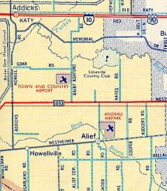
A 1962 street map depicted Town & Country Airport, along with the nearby Andrau Airpark.
The last photo which has been located of Town & Country Airport was a 10/19/66 USGS aerial view.
The distinctive X-shape of the 2 grass runways was still apparent, but there was no indication of any recent aviation use.
A 1974 aerial photo showed that houses had covered the site of Town & Country Airport, leaving no trace of the little airport.
A 2014 aerial view showed no trace remaining of Town & Country Airport.
The site of Town & Country Airport is located west of the intersection of South Dairy Ashford Road & Westella Drive.
Thanks to Fred Fiind for pointing out this airport.
____________________________________________________
Lite-Flite Ultraport, Katy, TX
29.775, -95.848 (West of Houston, TX)
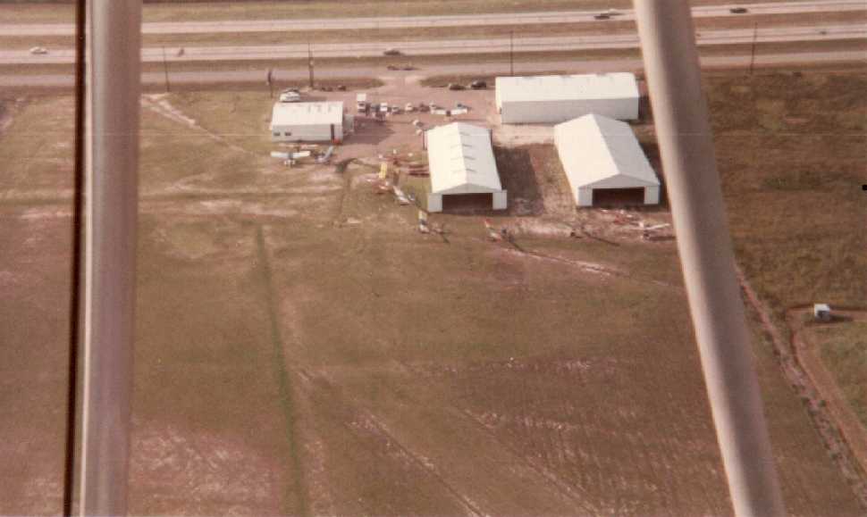
A February-March 1983 aerial view by Charlie Lanni looking north at the Lite-Flight Ultraport, showing the airfield area, hangars, and several ultralights.
This short-lived ultralight aircraft airfield evidently lasted no more than 9 years.
Lite-Flight Utlraport was not yet depicted on a 1982 aerial photo, which showed an open grass field with no buildings.
According to Charlie Lanni, “The Lite-Flite Ultraport was started in the early 1980s west of Houston in Katy, TX.
I first discovered Lite-Flite in the late summer of 1982 & bought a brand new Mirage ultralight there.
I took lessons that fall & solo'ed in my Mirage after about 12 hours of training.
I trained in a Condor ultralight, the most popular aircraft flying at Lite-Flite at the time.
It had a double-wide seat allowing us to fly dual in what was 'supposed' to be a single-seat ultralight.
The rules for flying dual as a Basic Flight Instructor with a student weren't enacted at that time.
In fact, the FAA Part 103 rules had only recently come out.”
Charlie continued, “Due to ultralight activity at that time getting a little out-of-hand...
(I recall one time at my office watching a WeedHopper fly along Highway 59 into downtown Houston, and know of others who did the same,
in fact, one time I landed my ultralight in a field alongside a 6-story office building so I could walk over to the 7-Eleven for a Coke)
the FAA held a meeting for us at the AstroHall.
In a nutshell they showed us how thick the book of FAA regulations was, how our 5 rules fit on one piece of paper,
and told us that if we didn't want to abide by those 5 rules, we could be inserted into the big, fat book along with everyone else!”
Charlie continued, “Lite-Flite was more than sales & instruction; they also manufactured the Spitfire ultralight right there at the airport.
Early ultralight pilots were cocky. The planes were so light & flew so slow they gave the impression of being safe & gentle.
Nothing could be further from the truth. Light winds swirling around the buildings can easily upset these craft.
I can think of no fewer than 5 crashes there at Lite-Flite. Three I witnessed, the last one being a fatality.
A new pilot was practicing touch-n-gos going the wrong direction (tail wind).
He got caught in the downdraft of the wind going over the top & down the back side of the hangar.
He couldn't pull out before hitting the power lines. He blew out a transformer & went nose-first into the next-door parking lot.
I suspect the jolt killed him before the impact.”
According to Andrew Haskins, “My grandfather Norman Haskins was the owner of the land from which the airport operated.
My dad Larry Haskins flew ultralights out of that airport & was involved in some of the operations.
My dad said they used to fly them from the airport to the auto show or boat show at the Astrodome
and land them in the parking lot for display then fly them back to the airport when the show was over.”
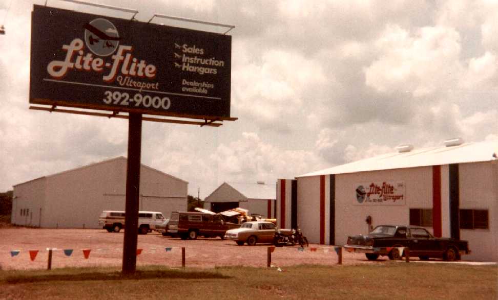
A February-March 1983 photo by Charlie Lanni of “from left-to-right: the manufacturing shop behind the sign, a hangar, (a second hangar is behind the sales office), and the sales office.”
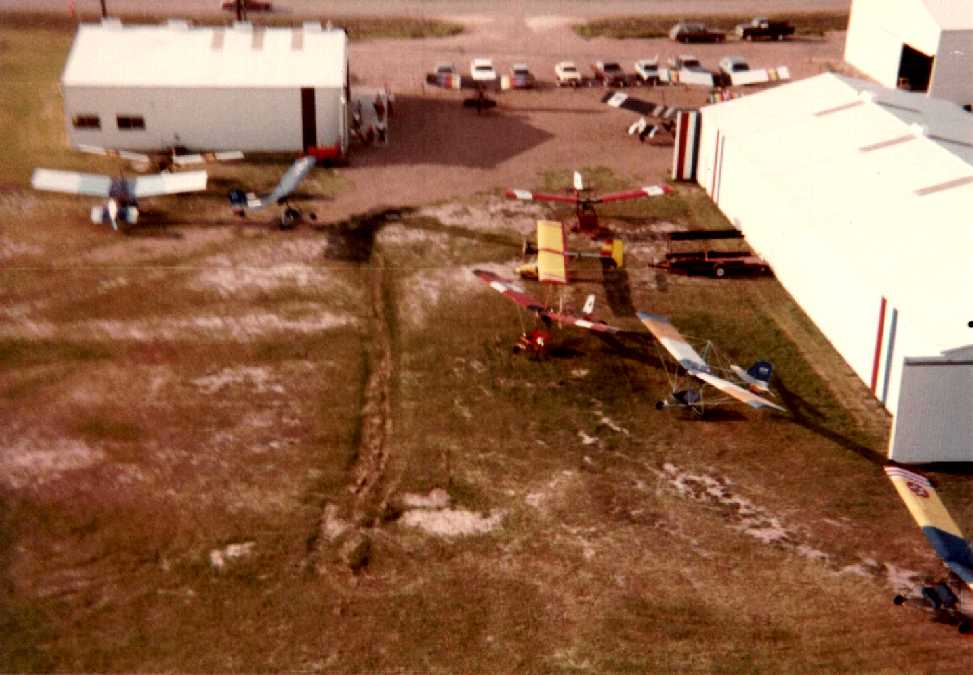
A February-March 1983 aerial view by Charlie Lanni looking north at the Lite-Flight Ultraport, showing several ultralights around the hangars.
Charlie recalled, “We really could take off & land into the wind in many directions, but the preferred direction (because it was longest) was what would've been Runway 12/30.
Later, another hangar was built between the 2 shown, an RV dealer built in the lot to the east. Power lines were run between the properties (that was where the poor fellow crashed).
And at one point, on the south end of the property, there was a pond that someone used to land his ultralight seaplane
(it was nothing more than an ultralight bolted to a little bass boat!).”
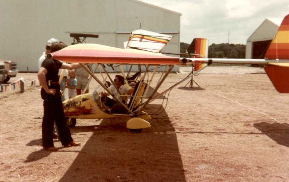
A February-March 1983 photo by Charlie Lanni at Lite-Flight Ultraport, of “an early Spitfire, fresh out of the factory.
It ran a Kawasaki 440 with a belt reduction drive. There's a Condor in the background”
A 1983 aerial view showed the Lite-Flight Utlraport buildings & a northwest/southeast grass runway.
Charlie continued, “Regulations, wrecks, and whatever, it seemed that Lite-Flite & ultralights lost some of their attractiveness.
They sold out to the business next door, I believe. Last I saw they were selling RV's there. And not the ones that fly.”
Aviation activities had evidently ceased at Lite-Flight by the time of a 1/1/89 aerial photo, as no aircraft were evident in the photo.
The airfield area otherwise remained clear.
Lite-Flight was no longer depicted on the January 1992 Houston Terminal Area Chart.
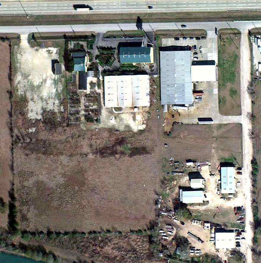
A 1/28/11 aerial view showed the former Lite-Flite hangars remained intact, and the majority of the former airfield area remained clear.

A March 2019 photo looking east at the former Lite-Flite hangars.
The site of Lite-Flite Ultraport is located southwest of the intersection of Interstate 10 & Manino Road.
____________________________________________________
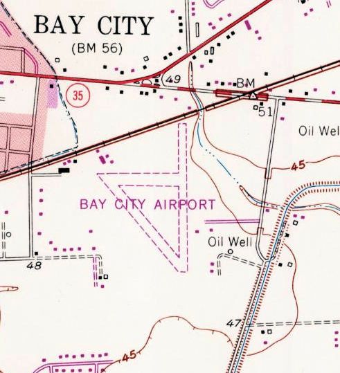
Bay City Municipal Airport (2nd location) (T26), Bay City, TX
28.979, -95.94 (Southwest of Houston, TX)
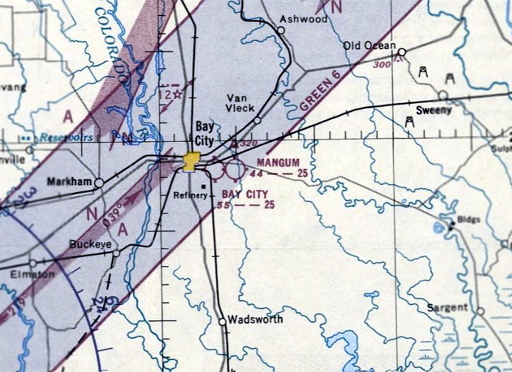
The 2nd location of Bay City Municipal Airport, as depicted on the February 1951 San Antonio Sectional Chart.
A predecessor Bay City Airport was located to the southwest of the town.
The 2nd location of Bay City Municipal Airport (to the southeast of the town) was evidently established at some point between 1950-51,
as it was not yet depicted on the August 1950 San Antonio Sectional Chart.
The earliest depiction which has been located of the 2nd location of Bay City Municipal Airport was on the February 1951 San Antonio Sectional Chart.
It depicted Bay City as having a 2,500' unpaved runway.
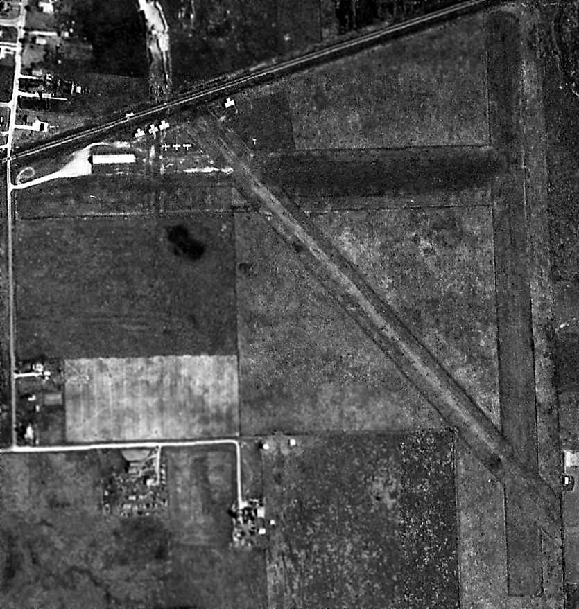
The earliest photo which has been located of the 2nd location of Bay City Airport was a 3/5/57 aerial view.
It depicted Bay City as having 3 unpaved runways,
with 3 light aircraft, 4 T-hangars & a few other buildings on the northwest side of the field.
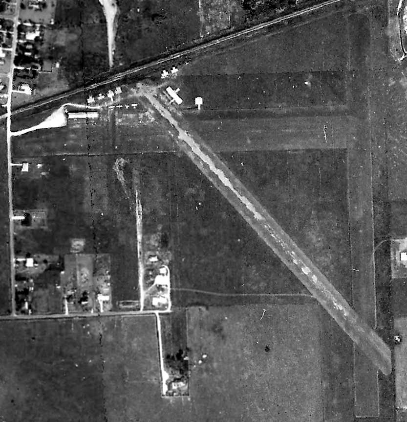
The last photo which has been located showing the the 2nd location of Bay City Airport while in operation was a 1965 aerial view.
Several more small hangars had been added at some point between 1957-65, and 4 light aircraft were parked outside.
The 1966 AOPA Airport Directory (according to David Brooks) described Bay City Airport
as having 3 turf runways: 2,470' Runway 17/35, 2,300' Runway 13/31, and 2,200' Runway 8/26.
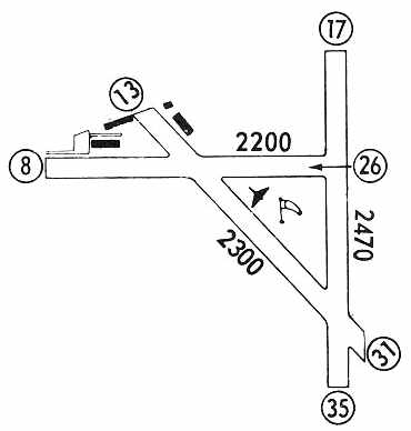
The 1971 Flight Guide (courtesy of David Brooks) depicted Bay City Airport as having 3 unpaved runways (the longest being the 2,470' Runway 17/35) & 4 small buildings on the northwest side.
The 1976 USGS topo map depicted Bay City Airport as having 3 unpaved runways & 4 small buildings on the northwest side.

The last aeronautical chart depiction which has been located of the 2nd location of Bay City Airport was on the March 1978 Houston Sectional Chart (courtesy of Jonathan Westerling).
It depicted Bay City as having a 2,500' unpaved runway.
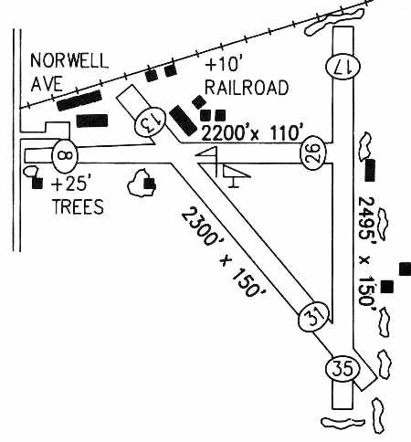
The 1989 TX Airport Directory (courtesy of David Brooks)
depicted Bay City Airport as having 4 unpaved runways, with the longest being the 2,495' Runway 17/35.
Ten small buildings were clustered around the northwest side of the field, with another 3 small buildings on the east side of the field.
The manager was listed as Jim Warnock.
Sarah Hinton recalled, “I finished up my private pilot training on the grass strip at Bay City.”
In the 1995 USGS aerial photo, it is not apparent if the 2nd location of Bay City Airport was still in use,
or had been closed already, as the field was still completely intact.
The outline of the 3 grass runways was still very recognizable,
and several hangars were clustered around the northwest corner of the field.
The 2nd location of Bay City Municipal Airport was closed at some point between 1989-2004,
as it was no longer listed among active airfields as of 2004.
An October 2004 photo by David Brooks of the abandoned 2nd location of Bay City Airport,
"taken from the where the runway used to come to the road, so the picture is looking southeast."
David Brooks visited the site of the 2nd location of Bay City Municipal Airport in October 2004.
His report: "Well - it is closed. Amazingly, the field is pretty much in tack.
The old hangars are in disrepair & rusting. The field has some fences across it.
So this field can definitely be put down in the closed list.
I could not get to the end of runway 35. The road has been torn up & a fence put in."
An October 2004 photo by David Brooks of the hangars at the 2nd location of Bay City Airport,
"taken from the railroad crossing which runs along the north side of the airfield.
The hangars are rusting & falling in a bit.
An October 2004 photo by David Brooks of what appears to be the abandoned wind direction indicator (tetrahedron) at the 2nd location of Bay City Airport.
A 12/31/08 aerial photo of the 2nd location of Bay City Airport showed it to remain completely intact,
including the outline of the 3 grass runways & several hangars on the northwest corner of the field.
An April 2022 photo looking east at the former hangars which remain on the northwest corner of the site of the 2nd location of Bay City Airport.
The 2nd location of Bay City Airport is located southeast of the intersection of Route 35 & Norvell Avenue.
Thanks to David Brooks for pointing out this airfield.
____________________________________________________
Columbus Municipal Airport (Original) (6R7), Columbus, TX
29.72, -96.562 (West of Houston, TX)
Columbus Municipal Airport, as depicted on the August 1948 San Antonio Sectional Chart.
The original airport for the town of Columbus was located on the northwest side of the town.
Columbus Municipal Airport was evidently established at some point between 1947-48,
as it was not yet depicted on the July 1947 San Antonio Sectional Chart.
The earliest depiction of the Columbus Municipal Airport which has been located was on the August 1948 San Antonio Sectional Chart.
It depicted Columbus Airport as having a 2,300' unpaved runway.
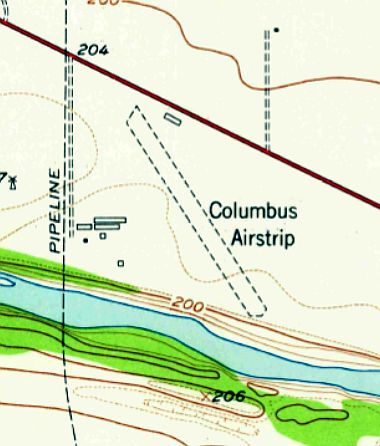
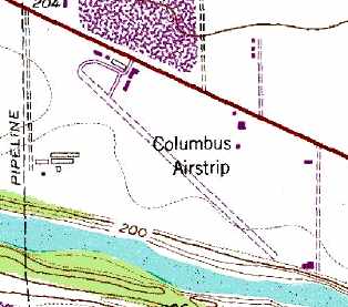
The 1957 USGS topo map depicted “Columbus Airstrip”
as having an unpaved northwest/southeast runway with 1 small building on the north side.
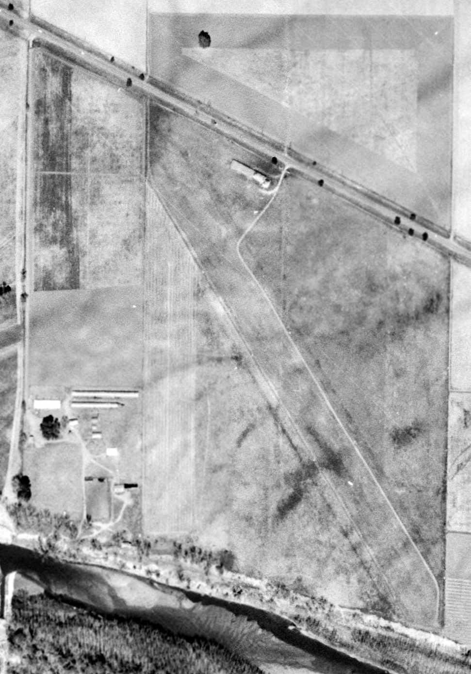
The only photo which has been located showing Columbus Airport while in operation was a 2/1/57 USGS aerial view,
which depicted the field as having a single unpaved northwest/southeast runway with one small hangar on the north side.
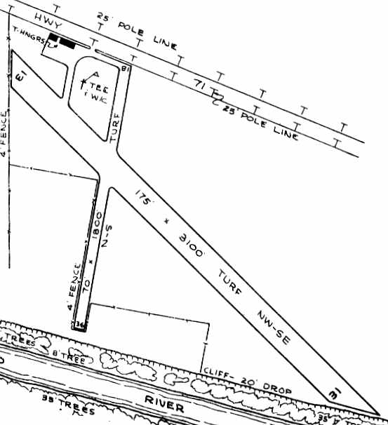
The 1963 TX Airport Directory (courtesy of Steve Cruse) depicted Columbus
as having 2 turf runways (3,100' Runway 13/31 & 1,800' Runway 18/36).
Taxiways led to a small ramp on the northwest corner of the field with 2 T-hangars.
The operator was listed as T. B. West, Inc., and the manager was T. B. West.
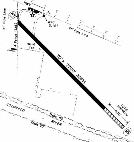
Columbus apparently gained a paved runway at some point between 193-67,
as the 1967 TX Airport Directory (courtesy of Brad Stanford)
depicted the field as having a 2,700' asphalt Runway 13/31, with a 600' turf overrun at the southeast end.
The former crosswind grass runway had apparently been abandoned. The manager was listed as T. B. West.
The 1981 USGS topo map depicted 2 other buildings having been built at the northwest corner of the airfield,
in comparison to the diagram in the 1967 TX Airport Directory.
The 1982 AOPA Airports USA directory (courtesy of Ed Drury)
described Columbus as having a single 3,200' asphalt Runway 13/31.
The field was said to offer fuel, major repairs, and tiedowns.
The operator was listed as Columbus Aviation.
However, the end was in sight for the airfield at this location,
as the remarks said, "Possible closing of airport for relocation."
That possibility was evidently carried out at some point within the next year,
as the 1983 TX Airport Directory (according to Chris Kennedy) depicted a new Robert R. Wells Airport, located 3.5 miles south of Columbus,
but the original Columbus Airport was no longer listed.
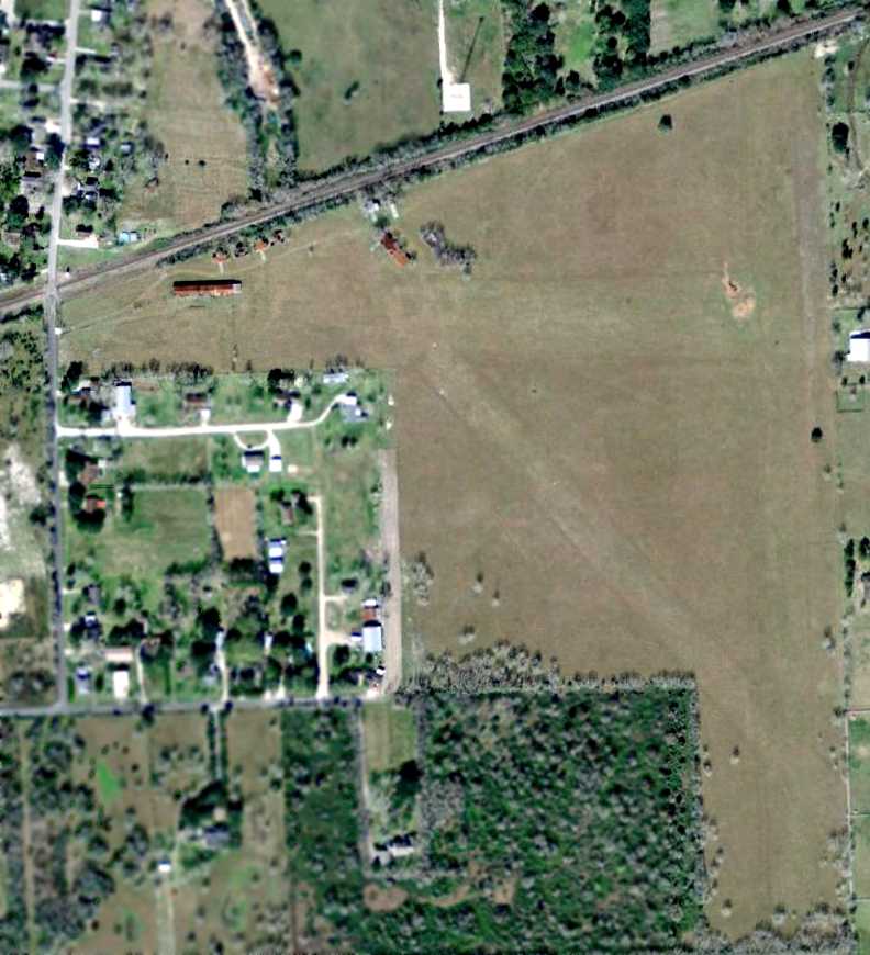
A 1995 USGS aerial view looking northeast showed the majority of the former Columbus Airport asphalt Runway 13/31 still remained intact,
but a pit of some kind appears to have been dug over the northwestern portion of the former runway.
None of the airport buildings remained at the site.
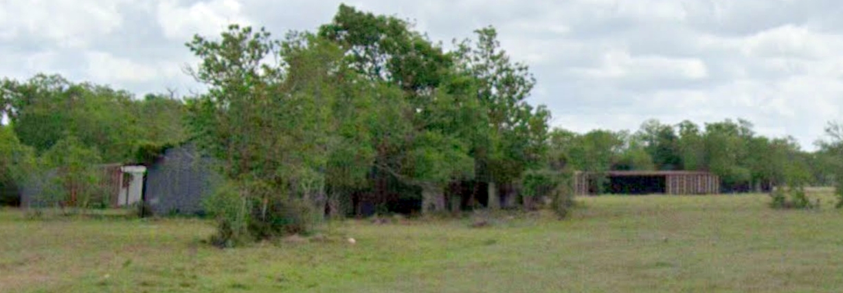
A 2005 photo looking north at the remains of the Columbus runway,
taken by the Colorado County CAP Composite Squadron (courtesy of Troy Millican).
A 2017 aerial view looking northeast showed a considerable portion of the former Columbus Airport asphalt Runway 13/31 still remained recognizable.
The original Columbus Municipal Airport site is located west of the intersection of Route 71F & Braden Lane.
Thanks to David Brooks for locating this airfield.
____________________________________________________
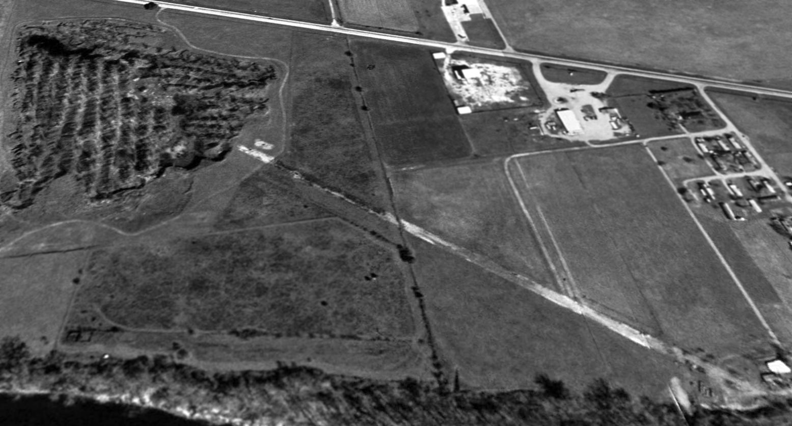
Sugar Land State Prison Airfield, Sugar Land, TX
29.6, -95.65 (Southwest of Houston, TX)
USGS topo map 1980.
Photo of the airfield while open has not been located.
This abandoned airfield is located on the grounds of the State Prison Farm, less than a mile south of the Sugar Land Hull Airport.
The Sugar Land State Prison Airfield was evidently constructed at some point between 1957-68,
as it was not yet depicted on a 1957 aerial photo.
The earliest depiction which has been located of the Sugar Land State Prison Airfield was on a 1968 aerial photo.
It depicted a single north/south runway, adjacent to the west side of Flanagan Road.
The only topo map depiction which has been located of the Sugar Land State Prison Airfield was on the 1980 USGS topo map.
It depicted the airfield as consisting of a single 3,200' north/south runway, adjacent to the west side of Flanagan Road.
Mike Hardwick reported in 2003, "About 15 years ago I came across a small airfield about 1 mile south of the Sugar Land Hull airport.
I was told it was a landing strip for the prison system airplanes."
Claud Pipkin reported, "Being that this airstrip is in the middle of the prison field, I suspect it's prime use is for crop-dusters.
I've seen the prison 'farm' and it is fairly large, crop field wise; a place for crop dusters would be handy."
John Mechura also reported in 2003, "I found this one while using the road next to it as a shortcut.
This is on State of Texas prison farm property. Officially its the Sugar Land Prison unit.
The irony is it is only about 1/2 mile south east of the Sugar Land Municipal Airport.
Its surface is concrete, and there is the frame to an old windsock nearby."
The Prison airfield was not listed in TX Airport Directories from 1963 or 1985, or in the 1962 AOPA Airport Directory.
In a 1/14/95 USGS aerial view looking northwest, the Sugarland Prison runway appeared to be paved, and in decent condition.
There did not appear to be any other aviation infrastructure at the site, other than the runway itself.
The date of closure of the prison airfield is unknown.
No airfield was listed at the site in 2003 FAA records, or depicted on the 2003 Sectional Chart.
In a 2004 aerial view looking northwest, the Sugarland Prison runway remained intact.
A 2005 aerial photo showed construction began over the site of the Sugarland Prison runway, eventually covering the site with new residential construction.
A 2017 aerial view looking northwest showed no trace of the Sugarland Prison runway.
____________________________________________________
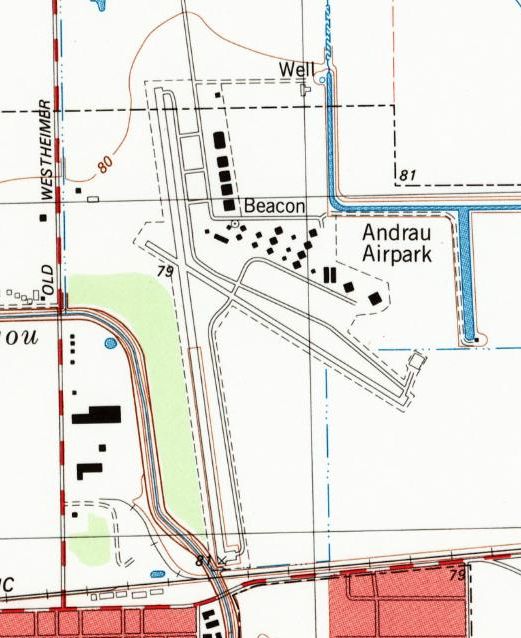
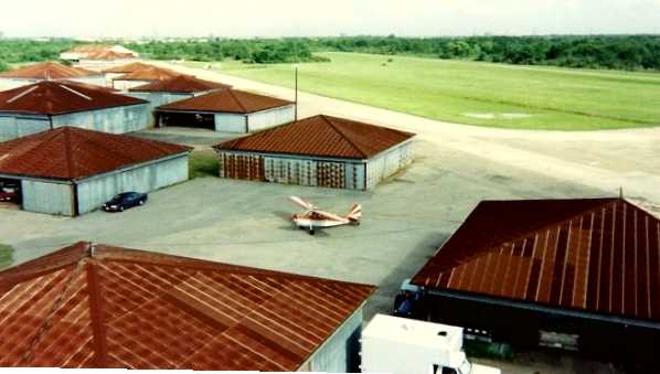
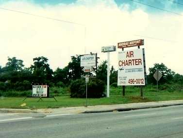
Andrau Airpark (AAP), Alief, TX
29.725, -95.586 (West of Houston, TX)
Andrau Airpark, as depicted on the August 1949 San Antonio Sectional Chart.
No airfield was yet depicted at this location on a 1944 aerial photo.
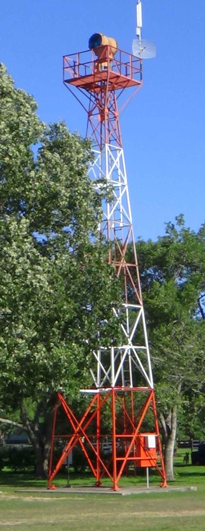
According to Archivaltexas, Andrau Airpark was was built in 1946 on a rice farm owned by Evert Willem Karel Andrau (nicknamed the “Flying Dutchman”).
According to a historical plaque on the beacon tower (courtesy of Bob Supina), a 1930s era airway beacon tower was relocated to Andrau Airpark in 1948 to serve as its airport beacon.
However, Andrau Airpark was not yet depicted at the January 1949 San Antonio Sectional Chart.
The earliest depiction of Andrau Airpark that has been located was on the August 1949 San Antonio Sectional Chart.
It depicted Andrau as having a 2,000' unpaved runway.
Airport owner Evert Andrau was killed in a plane crash in 1951, but his airfield continued to operate for another 47 years.
Andrau Airpark still was not yet depicted on a 1952 Humble Oil street map of Houston.
The earliest photo of Andrau Airpark that has been located was a 1953 aerial view.
It depicted Andrau Airpark as having 2 paved runways, a distinctive cluster of diamond-shaped hangars, and several aircraft, including what appeared to be a DC-3.
Claud Pipkin recalled of Andrau Airpark, "While in High School or just out of school [prior to 1957], I would go out there.
Baroid Corporation (drilling muds) had an Aero Commander that was often seen on the flight line. It was bright yellow with red trim."
A 1957 aerial view depicted Andrau as having 2 paved runways,
and a large number of hangars on the northeast side of the field, and over 30 aircraft on the field.
A 1962 street map depicted Andrau Airpark, along with the nearby Town & Country Airport.
The 1962 AOPA Airport Directory described Andrau Airpark as having 2 paved runways (the primary, Runway 16/34, was 4,710' long),
and listed the operators as Andrau Airpark Inc. & Dave Wallace Company.
Gregory Propps recalled, “I grew up near Andrau from 1962-74.
My first grade teacher lived right behind us, and she was married to the pilot of the Aero Commander that Bariod kept out there.
My best friend was their son. And the 'Legend' we were talking about came from the old Baroid pilot himself.
He maintained that in those days, there was 'party house' hidden in the trees on the south end of the property.
And the executives at Brown & Root Engineering used to fly customers in from out of town & put them up there.
You couldn’t get liquor-by-the-drink anywhere in Houston back then, and entertainment from the 'ladies' wasn’t as easy to come by either.
But you could get all that & more at the Brown & Root party house.
In the daytime, the activities included some skeet shooting, and a fully-stocked bass pond.
These guys would fly in & stay a few days, and never leave the airport.
And that’s how business got done in the wild west of Houston in the early days of the post-war oil boom.
On a more personal note, there was a little spot near the north end of the runway where you could pull off for some sight-seeing as the planes landed.”
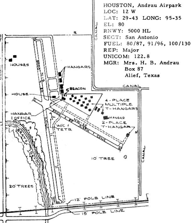
The 1963 TX Airport Directory (courtesy of Steve Cruse) depicted Andrau Airpark as having 2 asphalt/concrete runways: 5,000' Runway 16/34 & 3,000' Runway 11/29.
There were already a large number of hangars at Andrau in 1963: 6 large hangars & 17 4-place hangars. The manager was listed as Mrs. H. B. Andrau.
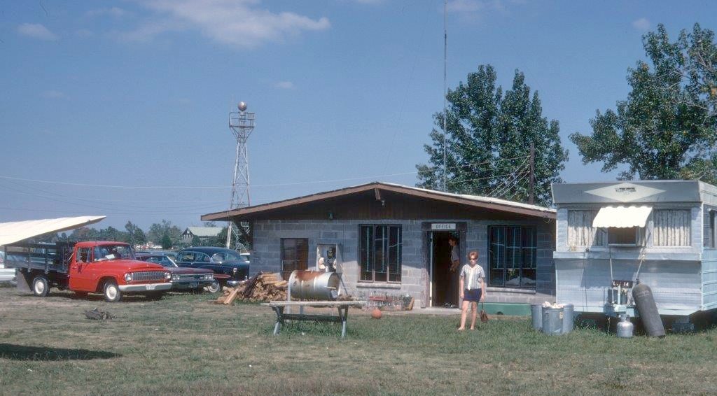
A 1968 photo by Dick Merrill “of the office for the Andrau Airpark. I think Mrs. Andrau was living on the airport at that time.”
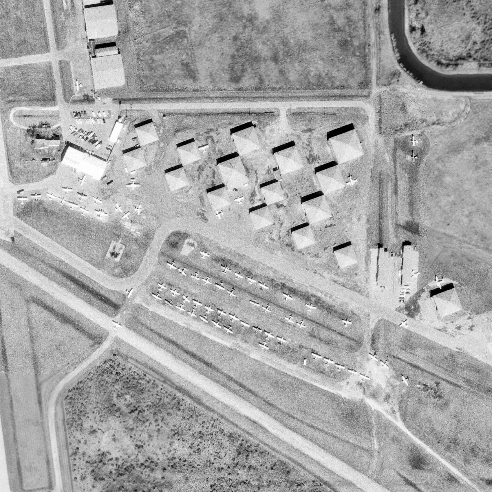
A 12/4/68 USGS aerial view showed a large number of hangars & light planes at Andrau Airpark.
A summer 1977 photo by James Brackley of a Piper Navajo & a Cessna Citation jet in front of Andrau hangars.
James noted, “At that time the airport was a bustling operation with over 100 tenants on the field.”
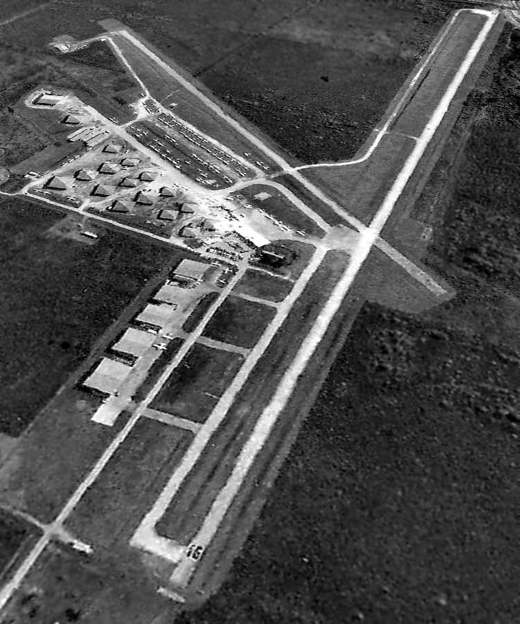
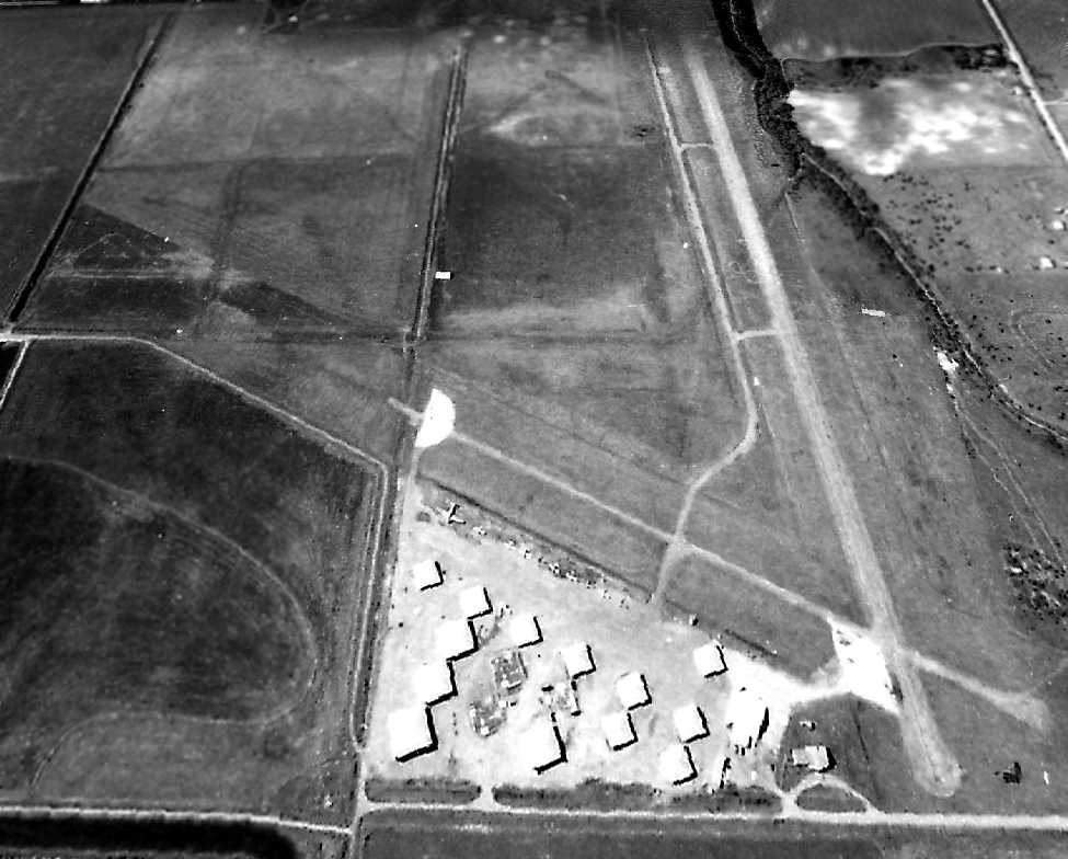
A 3/5/78 aerial view looking southeast at Andrau Airpark.
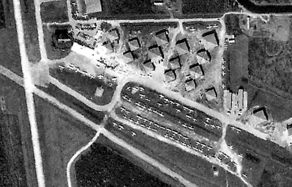
A 3/5/78 aerial view showing the large number of hangars & planes at Andrau Airpark.
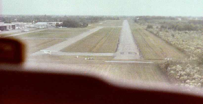
A 1979 photo by Ricky Baker taken while Robin Elston flew final approach to Andrau's Runway 16 in a Cessna 172.
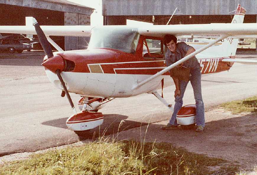
A 1979 photo of Robin Elston in front of a Cessna 152, after he had flown his 3-leg solo flight,
with some of Andrau's hangars visible in the background.
Robin recalled, “I took flight training at Andrau from Norris Aviation operated by Mary Jane Norris in 1979.”
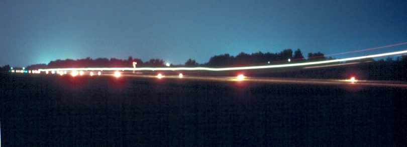
A 1979 photo by Robin Elston of a turboprop landing on Andrau's Runway 16 at night.
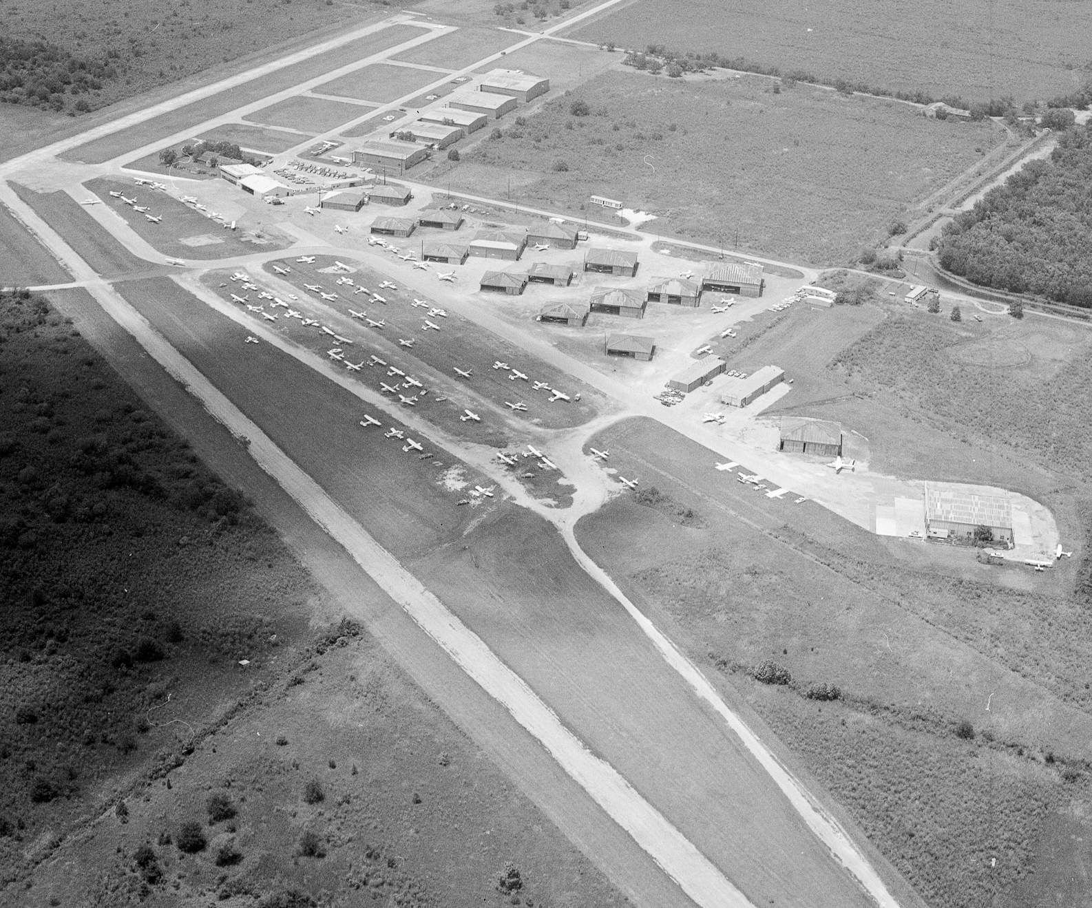
An August 1980 aerial view looking northwest (© by Robert Laird, used by permission) depicted Andrau Airpark at perhaps its zenith of popularity, with over 80 light aircraft visible on the field.
The 1980 Houston Terminal Chart depicted Andrau as having 2 paved runways, with the longest being 4,700'.
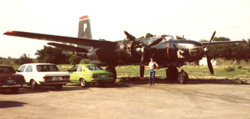
A circa 1980-81 photo of Mark Robinson in front of an A-26C Invader parked at the north end of Andrau.
Mark Robinson recalled visiting Andrau "twice in the early 1980s",
where he saw an A-26C Invader parked on the north end of the field.
"A group of Confederate Air Force folks were flying & maintaining this aircraft at the time.
I helped out on a sparkplug change & then saw it flying some time later when I was (again) visiting Houston.
There was what I think was a PacAero Learstar (executive Loadstar) based there.
I saw it fly one time, in 1981. Nicely maintained in a white/yellow/black paint job. I don't know who owned it."
The 1982 USGS topo map depicted Andrau Airpark as having 2 paved runways & a large number of hangars on the northeast side.
Hurricane Alicia caused damage at Andrau in 1983, flipping over at least one Cessna 152.
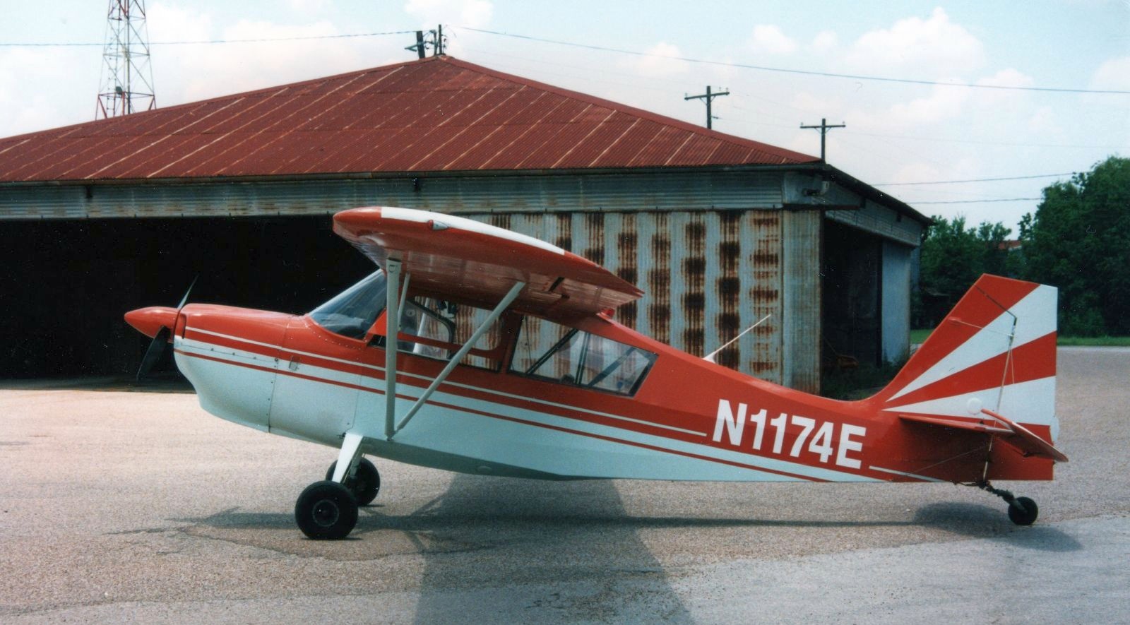
A circa 1980s photo of a Citabria among Andrau's hangars (courtesy of Jeffrey).
According to Jeffrey, “That Citabria (N1174E) was owned & operated by Texas Taildraggers flight school (Joy Bowden).”
Andrew Haskins reported that he learned to fly in Citabria N1174E.
A circa 1980s photo (courtesy of Jeffrey) of Andrau's “Westhiemer entrance sign”.
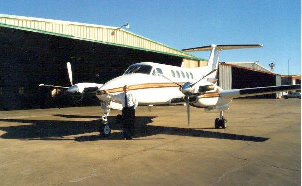
A circa 1980s photo of a King Air in front of Andrau's hangars (courtesy of Jeffrey).

A circa 1980s photo of the interior of the Andrau flight school (courtesy of Jeffrey).
Andrau Airpark, as depicted in the 1985 TX Airport Directory (courtesy of Steve Cruse).
Ranger Aircraft Enterprises (a maintenance shop operated by Tom McDonald) was located at Andrau in the 1980s.
Able Aviation was a flight school at Andrau, operated by Mary Able.
Walter Aviation moved to Andrau from Houston Southwest Airport in 1993 (according to Robin Elston).
The last aeronautical chart depiction which has been located of Andrau Airpark was on the July 1993 Houston Sectional Chart (courtesy of Ron Plante).
It depicted Andrau as having 2 paved runways, with the longest being 4,600'.

A 1995 USGS aerial view looking southwest showed only 6 aircraft parked outside at Andrau.
Andrau Airpark was closed in 1998, when the prices offered by developers for the land won out over continued operation of the airpark.
Apparently the Andrau family had been just waiting to sell,
as no improvements had been made to the facility in years - it looked pretty shabby.
According to Jim Schuler, “I used to work & fly out of there until it closed in 1998.
The youngest Andraus were waiting for the last of the eldest to pass on -
apparently it was set up that the field would remain open until a certain family member passed away.”
The Andrau property (755 acres) was purchased for $53 million in 1998 by Camden, a Houston realty company.
An undated photo of a TX Taildraggers Citabria in front of one of Andrau's hangars.

A 1998 aerial view by Jim Schuler looking east at Andrau Airpark, with the Houston skyline in the background.
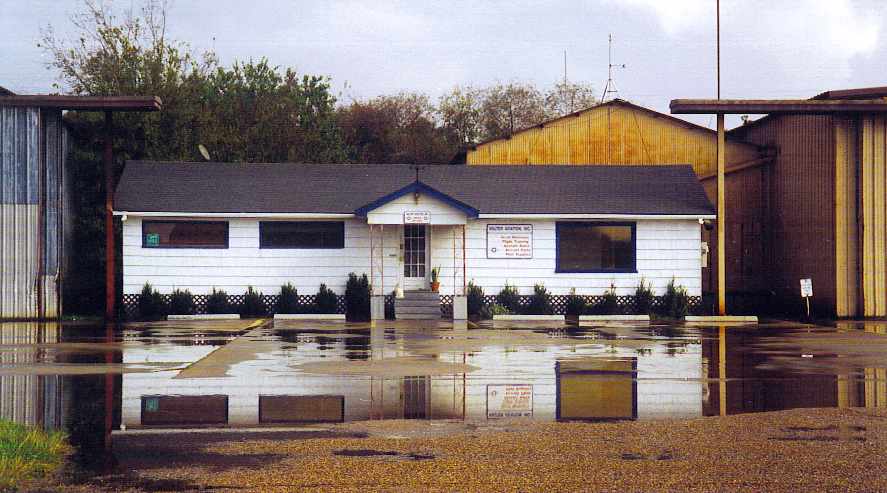
A 1998 photo by Jim Schuler of the office of Walter Aviation at Andrau Airpark.
According to Bob Supina, “When Andrau Airport closed, Covey Trails [Airport] acquired the historic beacon & tower that had been at Andrau.”
According to Peder Serkland, Andrau Airport was razed only a couple of months after being purchased.
As of 2001, upscale houses, a golf course and a large retail center were under development on the Andrau Airport site.
The Royal Oaks golf course community was being built on about 500 acres of the Andrau site,
and the Royal Oaks Village shopping center will be built another 32 acre parcel.
Tim Kraemer contributed a poignant commentary to the Andaru closure:
"Having grown up right near Andrau Airport I really get a sad feeling deep down inside knowing now that the airport of my childhood memories is gone.
It seems like in the seventies everybody knew somebody who owned or flew a Cessna.
I really wish somehow it would go back the other way, and private aviation could be 'cool & cheap' again.
It seems with all the insane traffic congestion we face, the sky is the only place left to go.
With all the small airports gone, the likelihood of that happening is dwindling fast."
The 2002 USGS aerial photo showed that the Andrau Airpark site is no longer even recognizable as having been a former airfield.
A 5/4/14 photo by Bob Supina of the last existing remnant of Andrau Airpark: its former airport beacon which was relocated from Andrau to nearby Covey Trails Airport.
The site of Andrau Airpark is located southeast of the intersection of Richmond Avenue & Old Westheimer Road.
Thanks to Steve Cruse for providing information about Andrau.
See also: Houston Chronicle 2/17/01.
____________________________________________________
Or if you prefer to contact me directly concerning a contribution (for a mailing address to send a check),
please contact me at: paulandterryfreeman@gmail.com
If you enjoy this web site, please support it with a financial contribution.
____________________________________________________
This site covers airfields in all 50 states.