Abandoned & Little-Known Airfields:
Texas: Northwestern Houston area
© 2016, © 2026 by Paul Freeman. Revised 2/1/26.
This site covers airfields in all 50 states: Click here for the site's main menu.
____________________________________________________
Please consider a financial contribution to support the continued growth & operation of this site.
Airman's Field (added 8/25/18) - Collier Airport (revised 5/6/22) - Flying Acres Airfield (revised 1/3/26) - Goodyear Blimp Airfield (revised 11/9/24)
Gulf Coast Airport (revised 8/28/22) - Harbican Airport / Sack-O-Grande Acroport (revised 11/21/18) - Jackson Airport / Weiser Airpark (revised 2/1/26)
___________________________________________________________
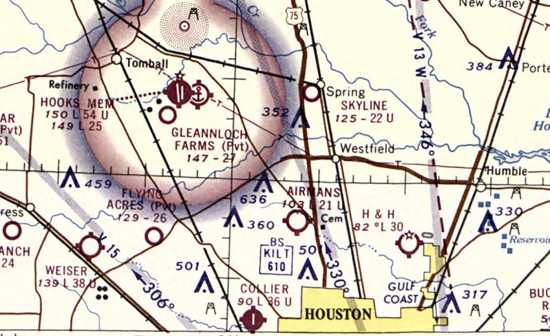
Gulf Coast Airport, Houston, TX
29.919, -95.408 (Northwest of Downtown Houston, TX)
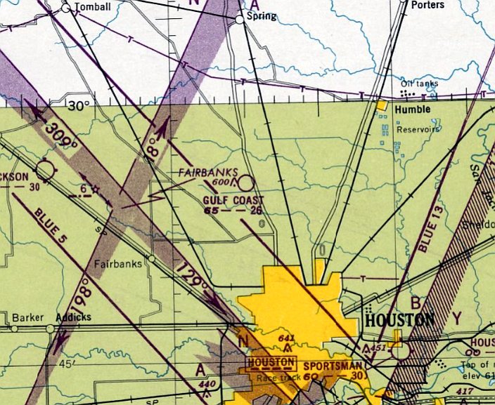
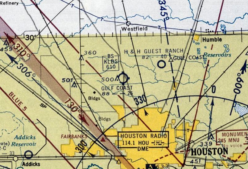
Gulf Coast Airport, as depicted on the August 1948 San Antonio Sectional Chart.
This small, short-lived general aviation airport was not yet depicted on the July 1947 San Antonio Sectional Chart.
According to Billyf, Gulf Coast Airport opened in 1948.
The earliest depiction which has been located of Gulf Coast Airport was on the August 1948 San Antonio Sectional Chart,
which depicted Gulf Coast Airport as having a 2,600' unpaved runway.
According to ADC78, “My grandfather got his pilots license out of Gulf Coast Airport using his GI Bill money.”
The earliest topo map depiction which has been located of Gulf Coast Airport was on the 1950 USGS topo map.
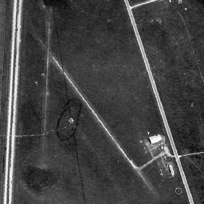
The earliest photo which has been located of Gulf Coast Airport was a 1952 TX Land Office aerial view.
It depicted Gulf Coast Airport as having 2 unpaved runways, with a few small buildings & 10 light single-engine planes on the southeast side.
The last photo which has been located of Gulf Coast Airport was a 1953 aerial view.
The number of aircraft visible on the field had decreased to 5.
The last topo map depiction which has been located of Gulf Coast Airport was on the 1954 USGS topo map.
It depicted Gulf Coast Airport as having 2 unpaved runways, with 3 small buildings on the southeast side.
According to Billyf, Gulf Coast Airport closed in 1955.
The last aeronautical chart depiction which has been located of Gulf Coast Airport was on the March 1956 San Antonio Sectional Chart,
which depicted Gulf Coast Airport as having a 2,600' unpaved runway.
Gulf Coast Airport was no longer depicted on the August 1956 San Antonio Sectional Chart.
A 1957 aerial view showed Gulf Coast Airport shortly after it had closed.
The runways were still intact, but all of the buildings had been removed, and there were no aircraft visible.
Aldine Senior High School had been built adjacent to the south side of the Gulf Coast Airport property.
A 1962 aerial view still showed the Gulf Coast Airport property remained largely unredeveloped.
A 1964 aerial view showed Stovall Middle School had been built over the Gulf Coast Airport site.
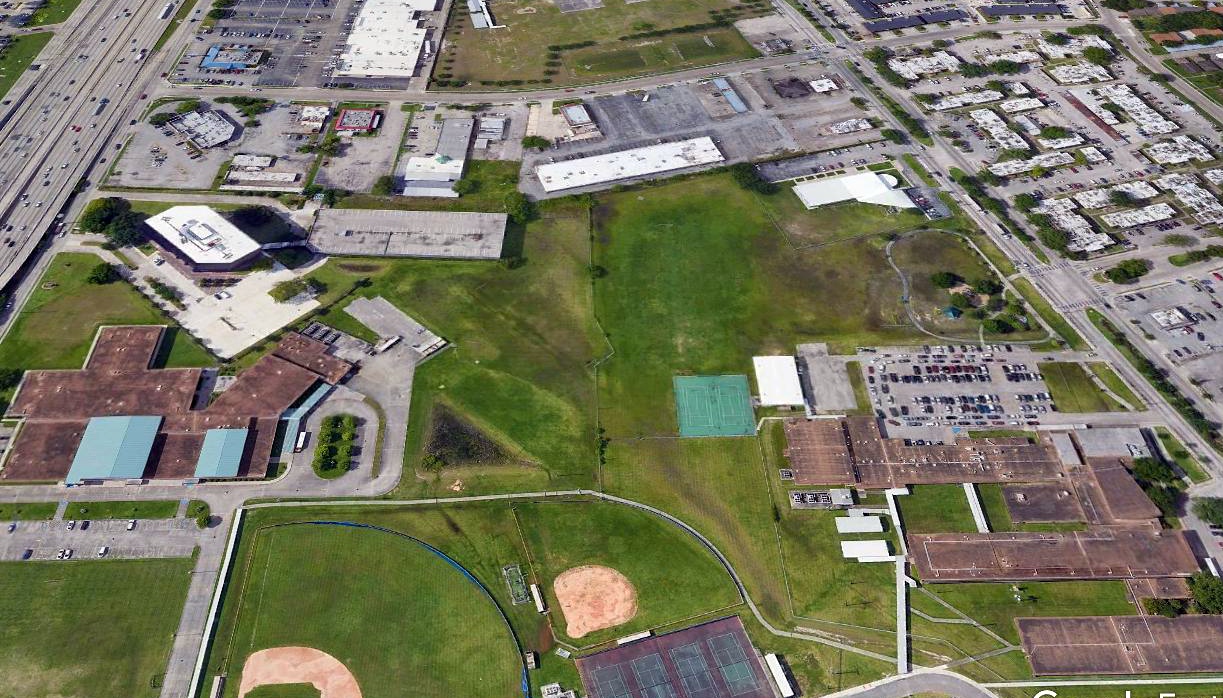
A 2018 aerial view shows the Gulf Coast Airport site covered by Stovall Middle School & other buildings.
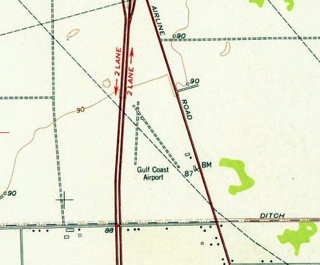
The site of Gulf Coast Airport is located along Airline Drive.
Although this may seem to denote the site's aviation history, other sources indicate that the Airline Drive name predated the airport,
that “Airline got it's name because that's how you'd get to Dallas in an 'air line' meaning it was a straight road, much like a line.”
Thanks to Waseem Malhi for pointing out this airfield.
____________________________________________________
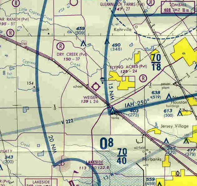
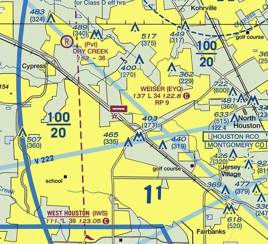
Jackson Airport / Weiser Airpark (KEYQ), Cypress, TX
29.935, -95.641 (Northwest of Houston, TX)
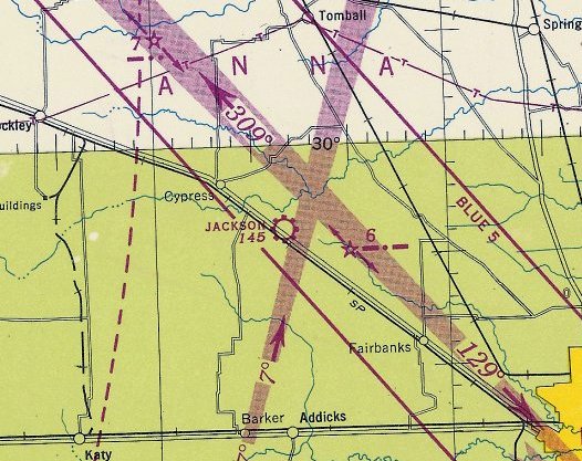
Jackson Airport, as depicted on the January 1947 San Antonio Sectional Chart (courtesy of Ron Plante).
Jackson Airport was evidently established at some point between 1945-47 (like hundreds of other small American airports, in the post-WW2 general aviation boom),
as it was not yet depicted on the August 1945 San Antonio Sectional Chart (courtesy of Ron Plante).
The earliest depiction which has been located of Jackson Airport was on the January 1947 San Antonio Sectional Chart (courtesy of Ron Plante),
which depicted Jackson as a commercial/municipal airport.
According to the Weiser Airpark website, “Cecil & Robert Weiser had a dairy farm on the East side of Huffmeister.
They expanded their farm in 1951 & purchased additional acres on the West side of Huffmeister.
This acreage extended from Huffmeister to Highway 290 & contained a small grass air strip named F. H. Jackson Airport.”
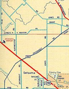
Jackson Airport, as depicted on a 1962 road map.
According to the Weiser Airpark website, “The air strip was renamed Weiser Airpark in 1963.
In 1963 they built a row of 10 hangars & in 1964 they built 2 more rows of 10 hangars each.
A gas pump was installed in 1963 but there were no credit cards & everyone wrote a gas ticket on the 'honor system' for what they purchased & were sent a bill every month.
The airport, which encompasses 31 acres, was separated from the dairy farm by a fence to keep the cattle off the runway & the airport continued to grow.”
The April 1965 Beaumont Sectional Chart (courtesy of Spencer Hamons) depicted depicted Weiser Airpark as having a 3,800' unpaved runway.
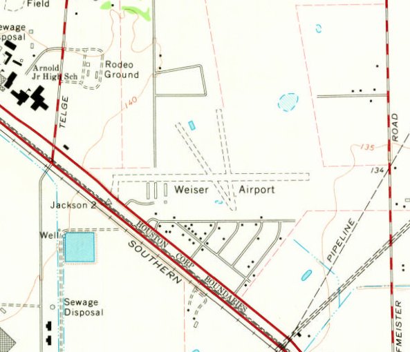
The 1970 USGS topo map depicted Weiser Airport as having 3 unpaved runways, with 4 buildings on the southwest side.
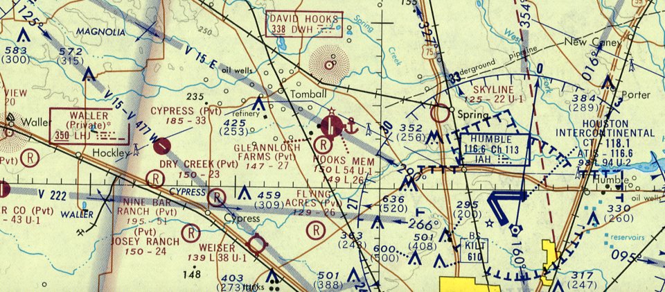
The April 1971 Houston Sectional Chart depicted (courtesy of Mike Meadows) depicted Weiser Airpark as having a 3,800' unpaved runway.
The earliest photo which has been located of Weiser Airpark was a 1977 aerial view.
It depicted Weiser as having 3 unpaved runways, with over 30 light aircraft parked near several hangars on the southwest side.
The 1980 Houston Terminal Chart depicted Weiser Airpark as having a 3,600' unpaved runway, and to conduct parachute operations.
According to the Weiser Airpark website, “The main runway 9/27 was paved in 1980 & runway lights & a rotating beacon were installed.
A 2,000' grass runway, 16/34, was used to handle crosswinds & is now used only for emergencies.”
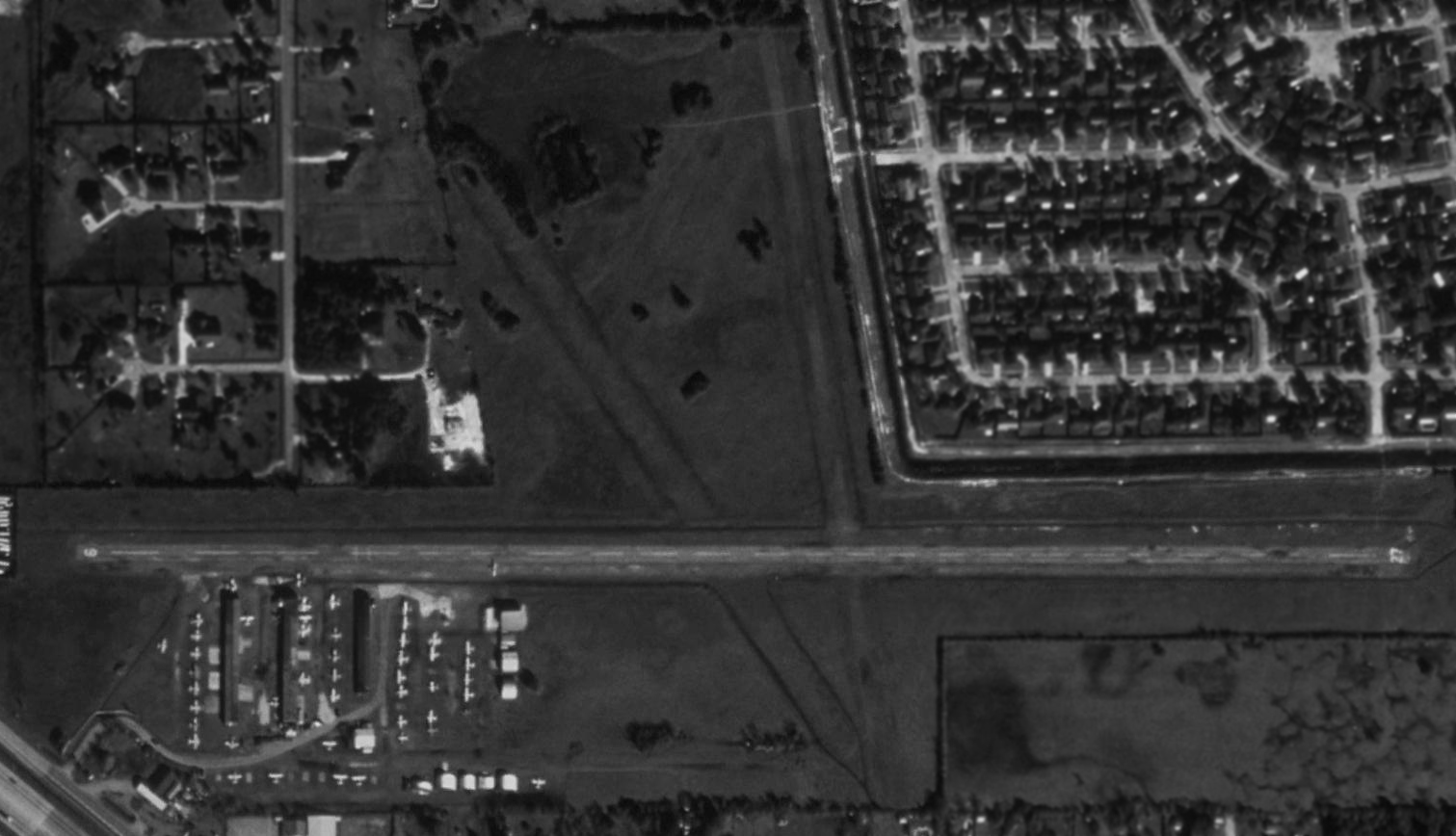
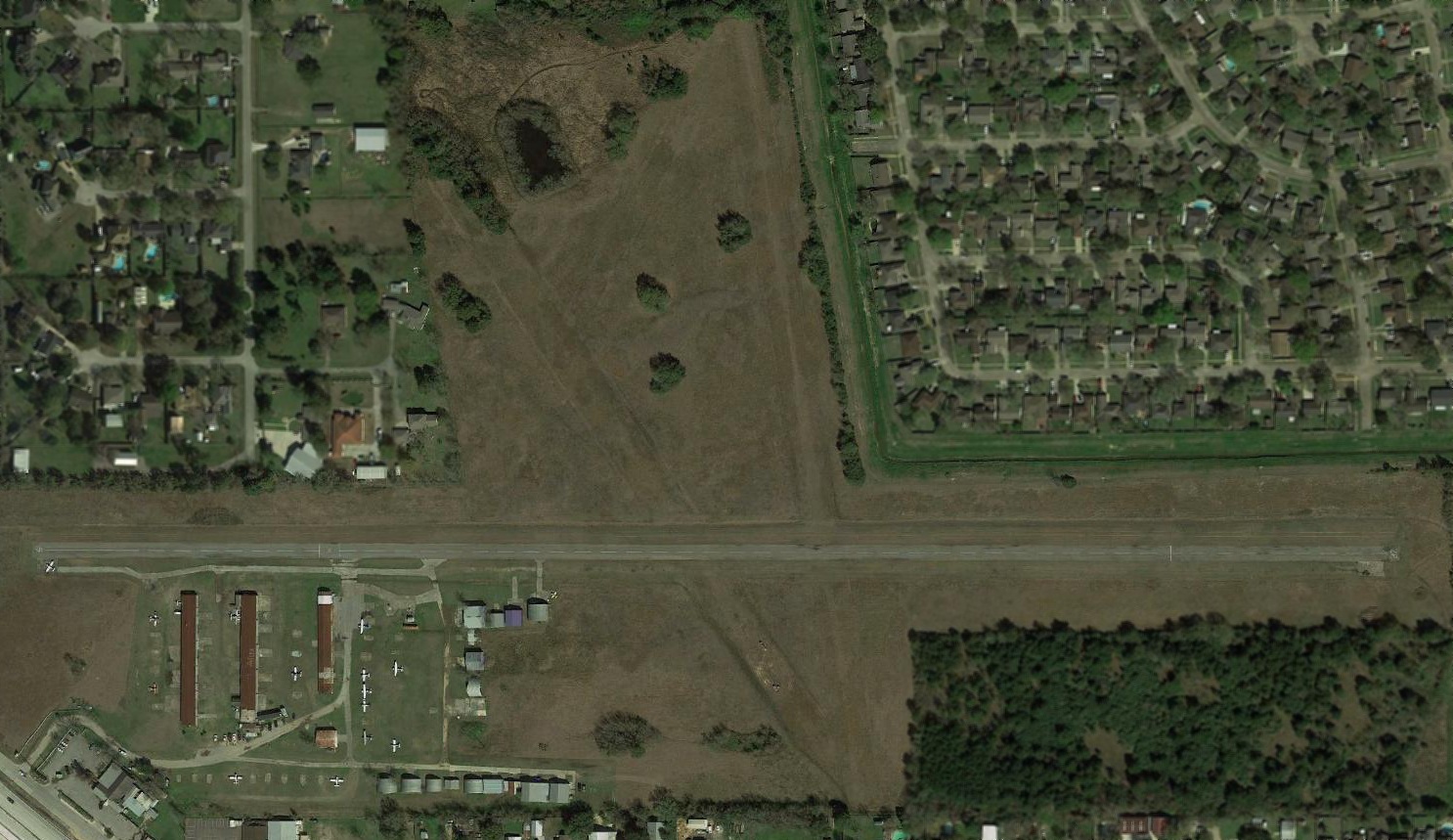
A 1995 USGS aerial view depicted Weiser Airpark as having a paved Runway 9/27 & 2 former grass crosswnd runways.
The airport was pictured at perhaps its zenith of popularity, with a total of almost 50 light aircraft visible parked outside.
According to the Weiser Airpark website, “In 2000 a self-serve credit card system was installed so customers & visitors could access the gas pump on a 24 hour basis.”
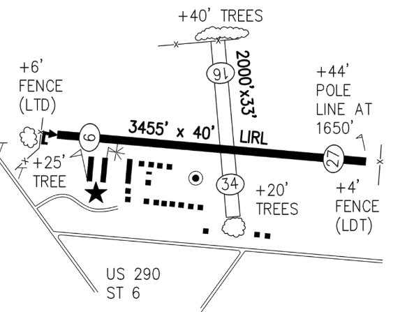
A 2015 airport diagram of Weiser Airpark from the TX Airport Directory (courtesy of Randy Coller)
depicted Weiser as having a 3,455' paved Runway 9/27, a 2,000' unpaved Runway 16/34,
and a large number of buildings on the southwest side.
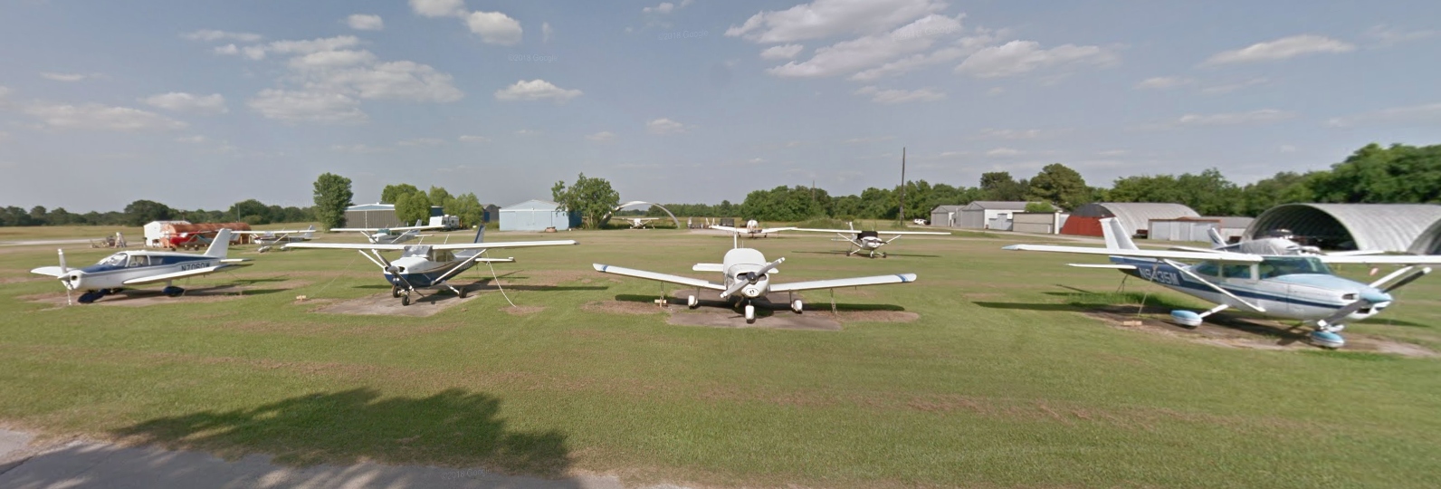
A circa 2015-2019 photo looking east at a variety of single-engine general aviation aircraft parked at Weiser Airpark.
For the year 2016, Weiser Airpark's FAA Airport/Facility Directory data said the field conducted an average of 104 takeoffs or landings per day.
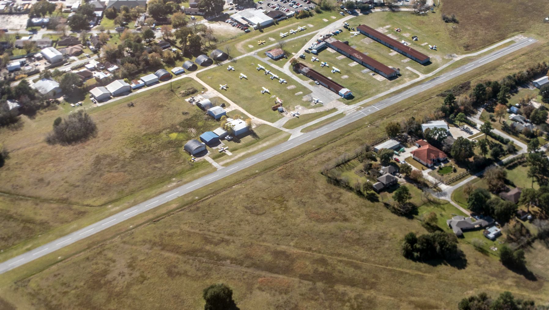
A 12/2/18 aerial view by Robert Laird looking southwest showed Weiser Airpark to remain well-used, with over two-dozen light aircraft visible on the field.
The Weiser Airpark website reported in 2019, “Weiser Airpark has been an institution in the Cypress area for decades & produced many pilots who are now captains with major airlines.
Many of the hangar renters at Weiser are business people & use their aircraft for personal and/or business use.
It is not unusual when you visit Weiser Airpark to see Cecil, Robert or one of the other Weiser family members mowing grass or maintaining the property on a tractor or a front end loader.
Weiser Airpark is a very unique airport. It is the only small airport in the Houston area that is located on a major freeway.
It has no employees, but if someone needs help, there are plenty of volunteers to assist.
It is probably the 'friendliest airport' in the United States. Pilots from all over the Houston area come to Weiser Airpark for the camaraderie & friendship it offers.
The coffee pot is usually on in the 'shack' & everyone likes to talk about flying, politics or anything else.
Many people visit the airport just to watch planes land & take-off. There are areas to view the aircraft within 50' of the runway.
It has been said that if someone learns to fly at Weiser, they can land at any airport.
Weiser has predominant crosswind landings which are sometimes a challenge but make better pilots of the students!
The airport has 2 independently owned flight schools: Houston Flight Training & The Flight School.
Both of the schools offer instruction for Private Pilot, Instrument, Multi Engine, Commercial & Certified Flight Instructor.
The mechanic on the field for over 30 years, Harold Wilson, owns Wilson Aircraft, Inc.
and is well known throughout the United States for his expertise in Beech aircraft, especially T-34s, as well as Cessna, Piper & others.
VFW Post 8905, next to the airport, has been great friends of the airport & sponsor many charitable events every year.
The Weisers have also supported the FFA & many other charitable events in the area.
This is truly a family owned & operated Cypress business!”
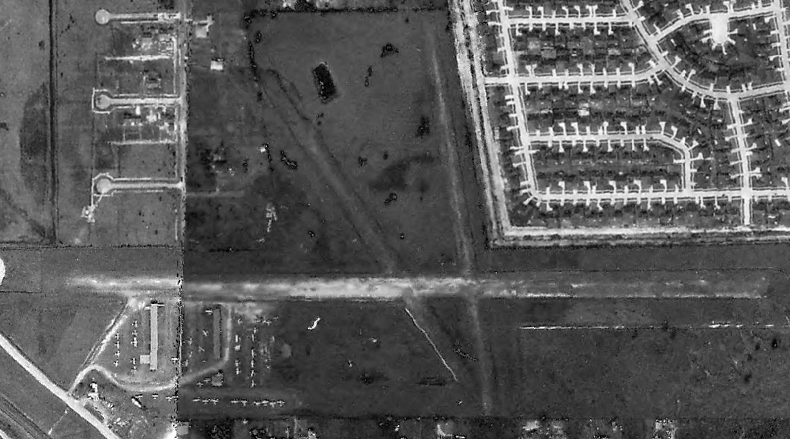
A 2019 aerial view showed the number of planes visible parked outside at Weiser Airpark had decreased to 15.
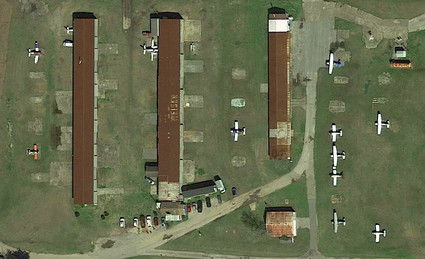
A closeup from the 2019 aerial view of the planes parked around the Weiser Airpark hangars, one of which had the airport name painted on its roof.
The 2019 Houston Terminal Chart depicted Weiser Airpark as having a 3,400' paved east/west runway.
As of 2019, Weiser Airpark's FAA Airport/Facility Directory data described it as having a 3,455' asphalt Runway 9/27 “in fair condition”
and a 2,000' turf Runway 16/34 “in poor condition”.
The owner & manager were listed as Cecil & Robert Weiser, and the airport was said to have a total of 78 based aircraft.
Unfortunately the end for the 'friendliest airport' in the United States came in 2019.
Mike Meadows reported, “Cecil Weiser died last year & the family have decided to sell for commercial property development.”
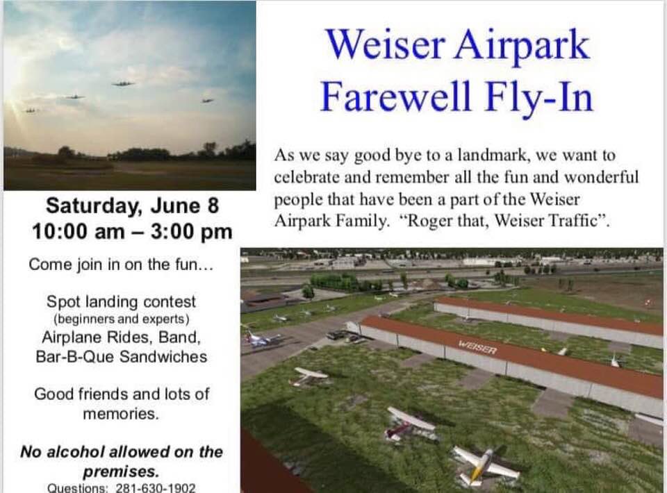
An announcement of the 6/8/19 “Weiser Airpark Farewell Fly-In” (courtesy of Mike Meadows).
Randy Coller reported, “I was advised by Brenda Weiser (daughter of one of the co-owners) that the airport was closed 11/3/19.”
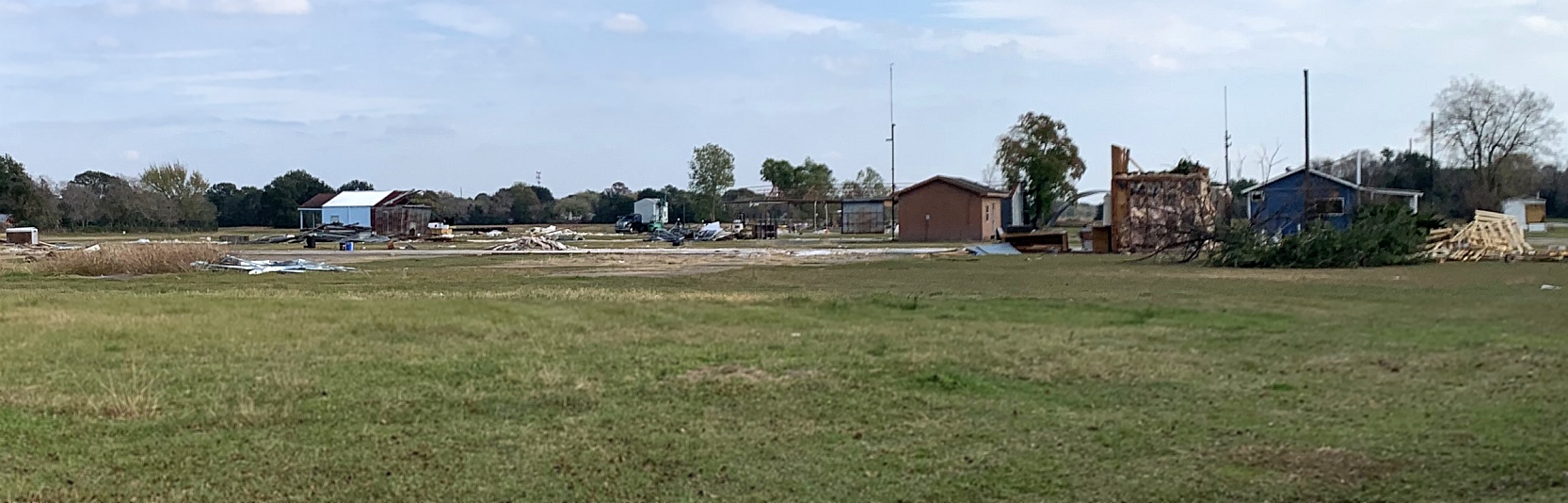
A sad 12/5/19 photo by John Mechura taken from the Weiser Airpark entrance road. John reported, “They were in the process of tearing the buildings down.”
Randy Coller reported in 2020, “I was advised by Brenda Weiser (daughter of one of the co-owners), it's been sold & the runways are gone.”
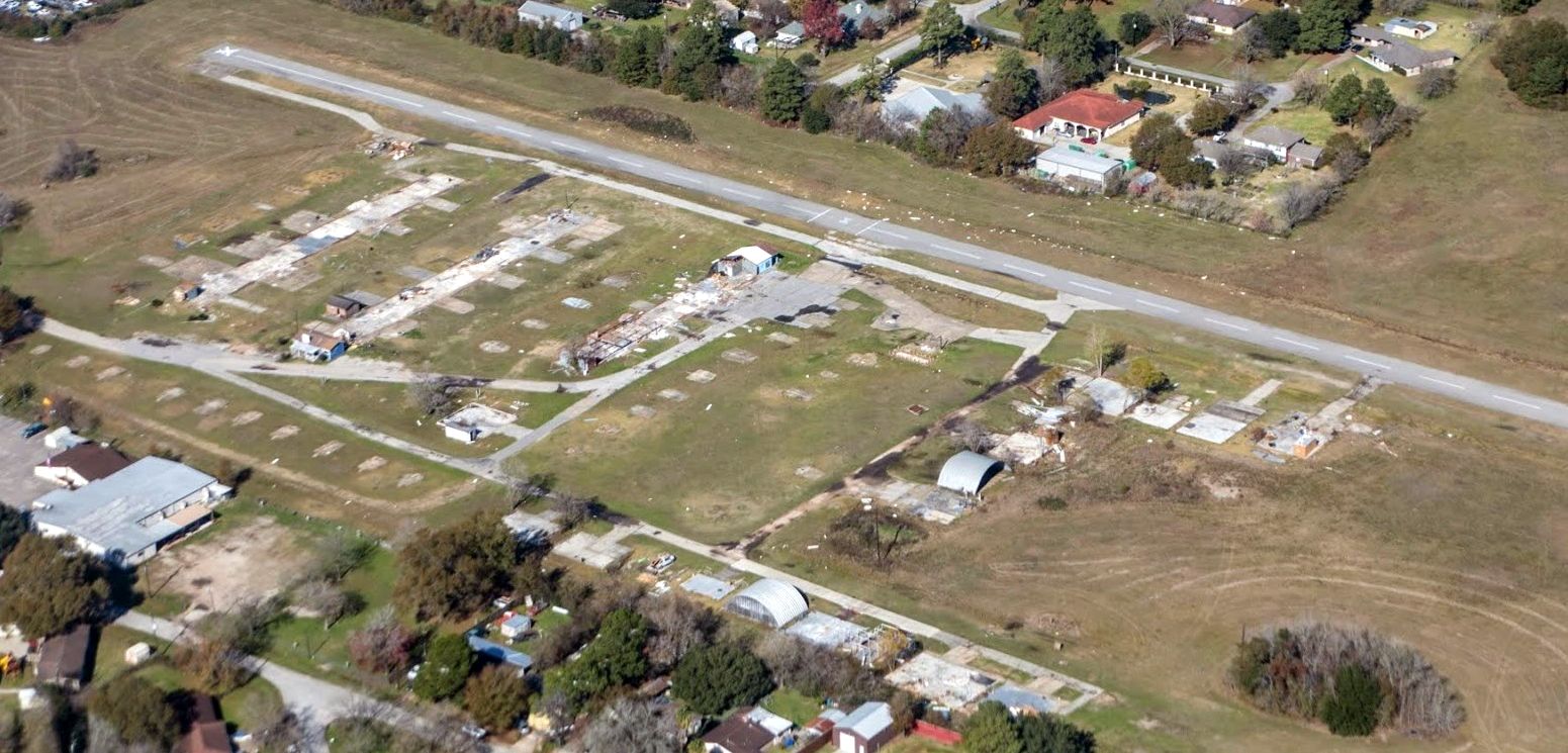
A sad 1/20/20 aerial view by Robert Laird looking northwest showed Weiser Airpark after most of the hangars had been demolished.
Thanks to Mike Meadows for pointing out this airfield.
____________________________________________________
29.962, -95.44 (Northwest of Downtown Houston, TX)
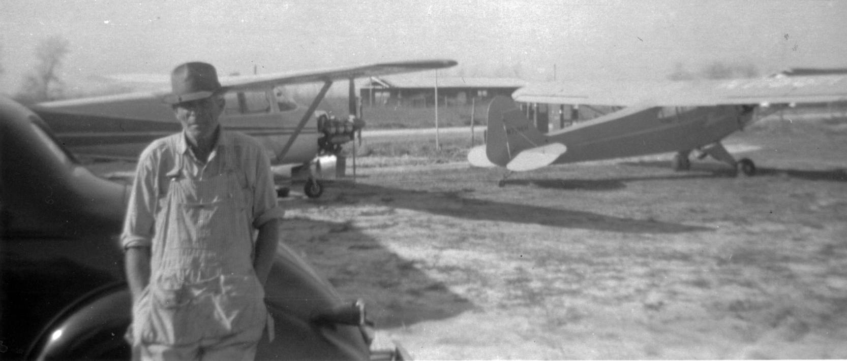
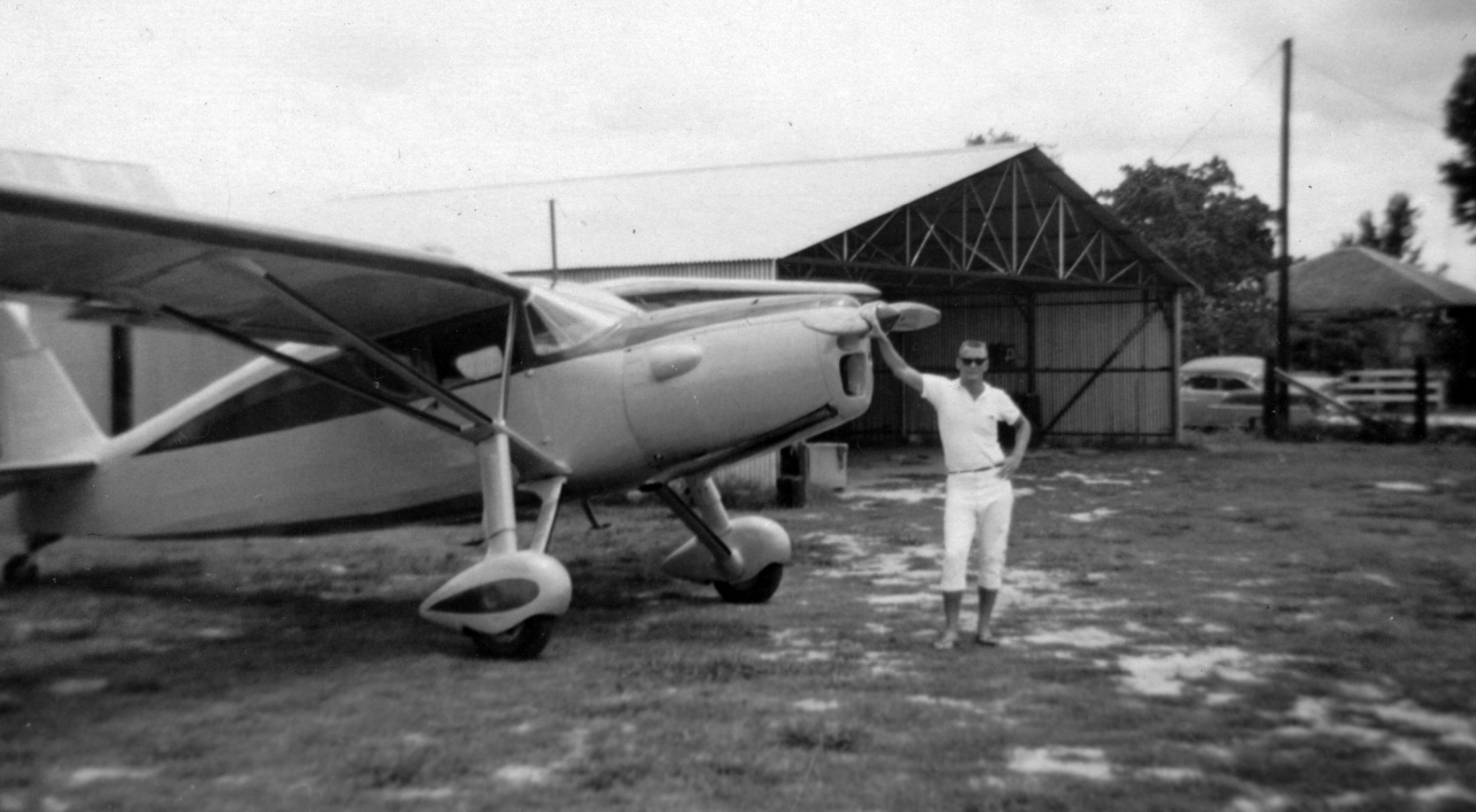
A circa 1955 photo of William "Bill" Hamons at Airman's Field in front of a 1938 Chevy Coupe, a Cessna, and a Piper J-3 Cub (courtesy of Spencer Hamons).
A 1953 aerial photo did not yet show any sign of an airfield at this location – just farm fields.
Spencer Hamons recalled, “The Hamons Family consisting of William (Bill) Hamons & his wife Emma (Helen) Hamons, and their son Warren (Sonny) Hamons
lived between U.S. Highway 75 (now Interstate 45) & Steubner Airline (now Veteran’s Memorial Drive).
In the early 1950s, Mr. Dromer, a nearby neighbor, took [flying] lessons, earned his Pilot’s License, and purchased an Ercoupe which he kept at various small airports around North Harris County.
In 1955, Mr. Dromer asked Bill Hamons for permission to land his Ercoupe in the pasture so he could taxi across the street to his own property,
in exchange for some culverts, a wire fence, and some other miscellaneous work – to which Mr. Hamons eagerly agreed.
This became Runway 1/19, the 1,680' North/South runway.”
The earliest depiction which has been located of Airman's Field was a circa 1955 photo of William "Bill" Hamons in front of a 1938 Chevy Coupe, a Cessna, and a Piper J-3 Cub (courtesy of Spencer Hamons).
A 1957 aerial view showed Airman's Field to have an unpaved north/south runway,
with 3 light single-engine aircraft parked across the street to the south.
Spencer Hamons recalled, “As time went on, another friend asked, and then another.
Soon there was a yard full of airplanes & more weekend fliers were asking Mr. Hamons about starting an airport with tie-downs in the pasture.
Up to this point, pilots had to remember to run the cows off the runway before takeoff, and perform a low-pass before any landing; but with the popularity of the airport, the last few cows were sold.
In 1959, two new runways were established, 1,820’ Runway 9/27 & 2,100’ Runway 12/30.
T-hangars & a larger rectangular hangar provided enough hangar space for 22–25 aircraft, and there was a small Unicom office.
Fuel & oil were available on-field, but no maintenance services were ever offered at this airport.
It was decided that with all of the improvements being made at what was an 'official' airport now, that the airport should have a name.
Mr. Hamons called a meeting of the owners of all of the various aircraft & solicited their input.
After kicking around various ideas in true Texas style, the name 'Airman’s Field' was voted-on & selected.”
Spencer continued, “All the airplane owners were working people & 'weekend pilots'.
Airman’s Field was a busy place on weekends, and as time went by, a lot of pilots would manage to come fly a bit in the late afternoons & evenings.
Airman’s Field became a launch point for pilots to go out & see family, and was a meeting place for other pilots to come in & meet others.
One of these visiting pilots was a gentleman by the name of Edmonds who flew a beautiful Cessna 120. Mr. Edmonds was the pilot to give Sonny his first flight.”
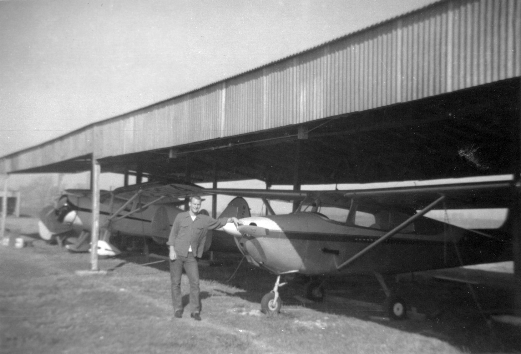
A 1959 photo of Sonny Hamons in front of a Cessna at Airman's Field, also note the radial-engine Fairchild in the background (courtesy of Spencer Hamons).
A June 1959 photo of a Fairchild with inverted 6 cylinder inline Ranger engine 6-440C-36 engine in front of a hangar at Airman's Field (courtesy of Spencer Hamons).
A June 1959 photo of several single-engine aircraft under shade hangars Airman's Field (courtesy of Spencer Hamons).
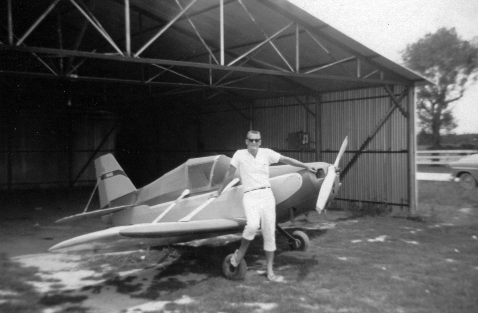
A June 1959 photo of Marcus Heath in front of an unidentified single-seat aircraft (a hombuilt?) in an Airman's Field hangar (courtesy of Spencer Hamons).

A June 1959 photo of Sonny Hamons & Marcus Heath in a Ryan PT-22 at Airman's Field (courtesy of Spencer Hamons).
Airman's Field was not yet depicted on the August 1961 San Antonio Sectional Chart.
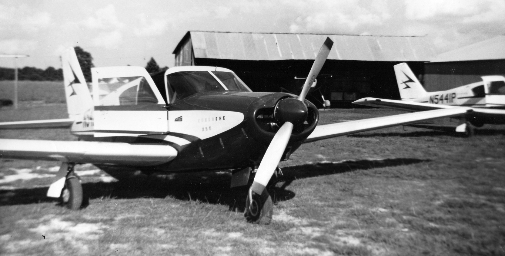
A 1962 photo of Piper Comanche N5441P in front of Airman's Field hangars (courtesy of Spencer Hamons).
A 1962 aerial view depicted Airman's Field as having 3 grass runways, and a large number of small hangars & several single-engine aircraft on the south side.
Spencer Hamons recalled, “Mr. Hamons’ son, Warren (called Sonny), always enjoyed the activities, and in his late-teens became involved with every aspect of the operation.
His duties included managing the office & the hangars, grass mowing (remember, these were turf runways), managing & pumping fuel, responding to radio requests, and whatever else needed to happen.
Sonny managed many of the airport operations until he left for Lamar Technical University.
Once he left for college, Sonny would return home on weekends & holidays to help out at the airport.
In 1964, Sonny was drafted into the Army.
Sonny’s duty-station was at Ft. Hood, TX, so when he was good enough to earn a weekend pass & on holidays,
he continued to return to Airman’s Field to enjoy being around private general aviation operations & helping out the family business.”

A 1964 photo of Piper Comanches N5441P & N5424P in front of Airman's Field hangars (courtesy of Spencer Hamons).
The earliest aeronautical chart depiction which has been located of Airman's Field was on the April 1965 Beaumont Sectional Chart (courtesy of Spencer Hamons).
It depicted Airman's as having a 2,100' unpaved runway.
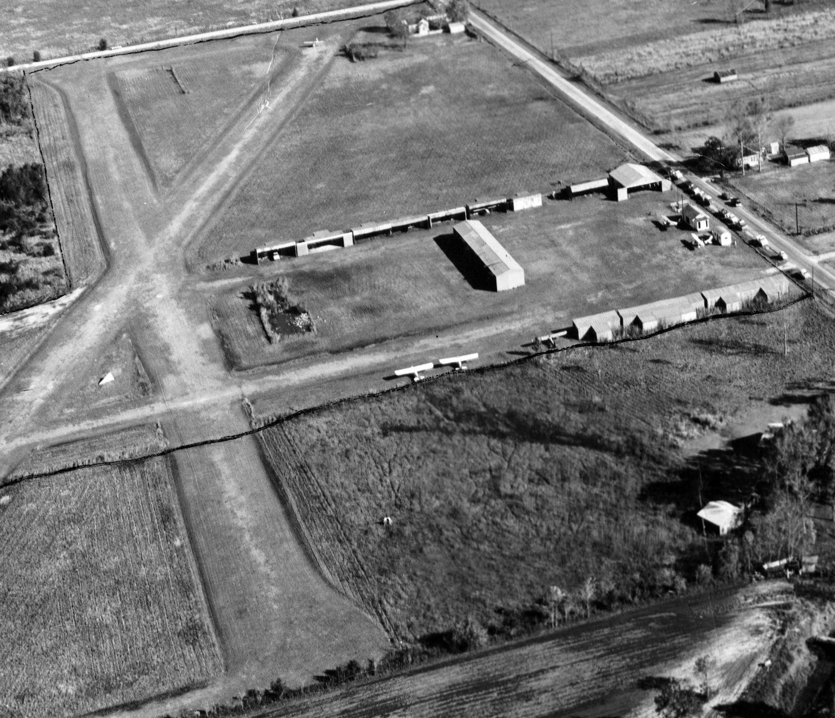
The earliest aerial photo which has been located of Airman's Field was a March 1966 aerial view looking southeast (courtesy of Spencer Hamons).
It depicted Airman's as having 3 grass runways, and a large number of small hangars & several single-engine aircraft on the south side.
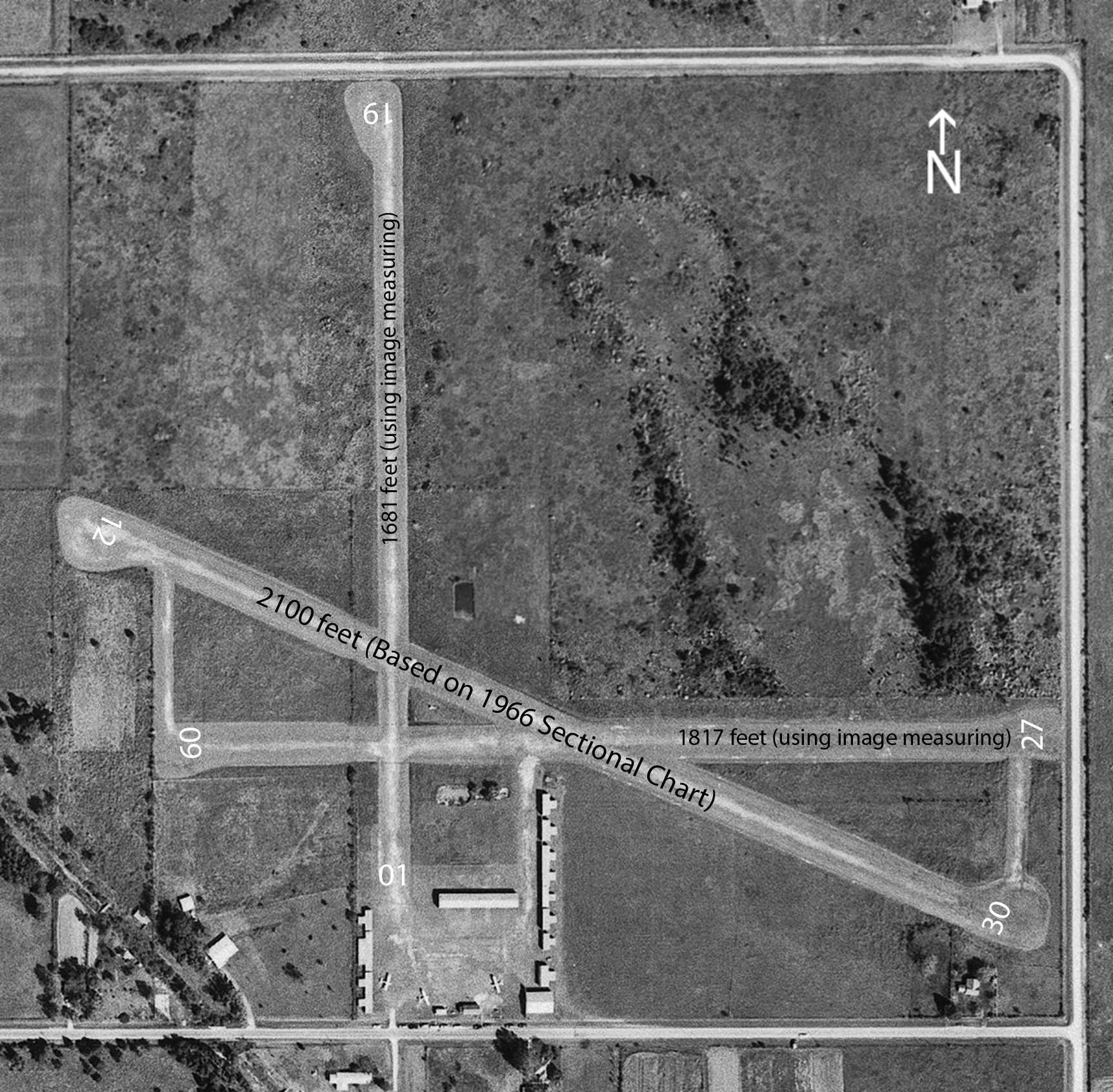
A 10/16/66 aerial view of Airman's Field annotated by Spencer Hamons to show the runway numbers & lengths.
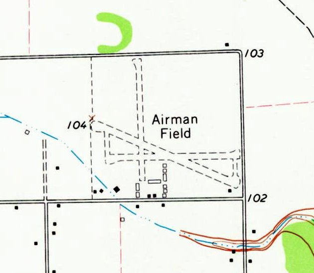
The only topo map depiction which has been located of Airman's Field was on the 1967 USGS topo map.
It depicted “Airman Field” as having 3 unpaved runways & a large number of small buildings on the south side.
The last aeronautical chart depiction which has been located of Airman's Field was on the September 1967 Beaumont Sectional Chart.
It depicted Airman's as having a 2,100' unpaved runway.
Spencer Hamons recalled, “Airman’s Field was shut-down in 1968 due to a lawsuit by the City of Houston seeking to close the airport when Houston Intercontinental Airport opened.
The City of Houston lost their imminent domain suit to obtain the land.”
Airman's Field was no longer depicted on the September 1970 Houston Sectional Chart (courtesy of Ron Plante).
A 1973 aerial view showed a sad sight: Airman's Field's runways were still recognizable, but all the hangars had been removed & the field was devoid of aircraft.
Yet another of America's thousands of grassroots airports lost to “progress”.
The last photo which has been located showing any trace of Airman's Field was a 2006 aerial view looking north.
The last remnants of the southeastern portions of 2 runways were still recognizable on the southeastern portion of the site.
A 2008 aerial view showed housing had been built on the southeastern portion of the Airman's Field's site, erasing the last vestige of the small airport.
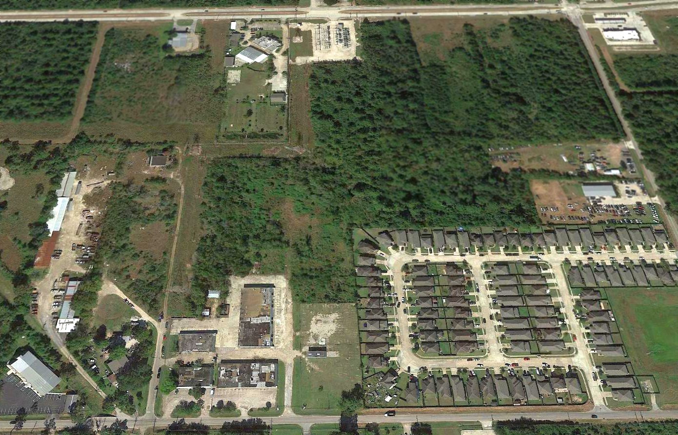
A 2017 aerial view looking north showed no trace remained of Airman's Field.
The site of Airman's Field is located northwest of the intersection of Hugh Road & Spears Road.
Thanks to Spencer Hamons for pointing out this airfield.
____________________________________________________
29.88, -95.48 (Northwest of Downtown Houston, TX)
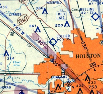
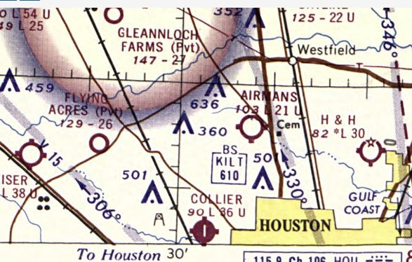
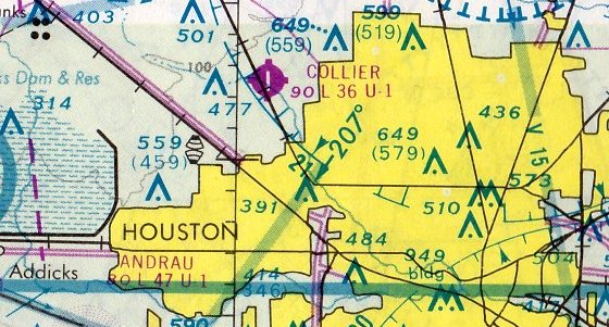
Collier Airport, as depicted on the August 1961 San Antonio Sectional Chart.
This small general aviation airport was evidently established at some point between 1960-64,
as it was not yet depicted on a 1953 aerial photo nor on the February 1960 Beaumont Sectional Chart.
The earliest depiction which has been located of Collier Airport was on the August 1961 San Antonio Sectional Chart,
which depicted Collier as having a 3,500' unpaved runway.
Collier Airport gained a paved runway at some point between 1961-64,
as the 1964 Sectional Chart depicted Collier as having a north/south paved 3,600' runway.
Dale Muenzler recalled, “Collier Field... I soloed & finished my private ticket around 1965.
Bill Collier was a Colonel in the Air Force Reserve or the Army Reserve. He owned & ran this airport for many years.”
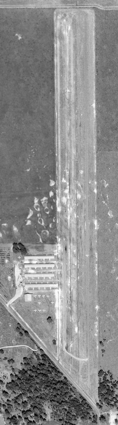
The only photo which has been located of Collier Airport was a 10/16/66 USGS aerial view,
which depicted Collier as having a single north/south runway,
with 4 rows of T-hangars, an office, and 11 light single-engine aircraft on the west side.
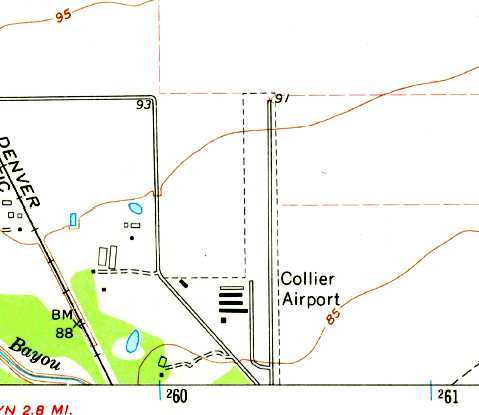
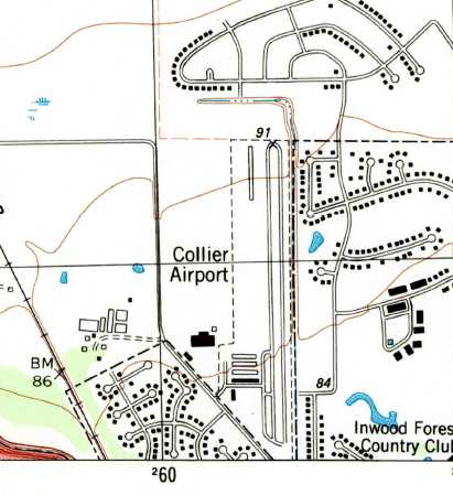
The 1967 USGS topo map depicted Collier Airport as having a single paved north/south runway with 5 buildings on the west side.
The September 1967 Beaumont Sectional Chart depicted Collier Airport as having a north/south paved 3,600' runway.
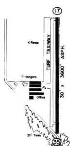
The 1970 TX Airport Directory depicted Collier Airport as having a 3,600' paved Runway 17/35, with 4 rows of T-hangars & an office on the west side.
The last aeronautical chart depiction which has been located of Collier Airport was on the February 1975 Houston Sectional Chart.
It depicted Collier as having a north/south paved 3,600' runway.
Collier Airport presumably fell victim to rising suburban property values (like thousands of other small general aviation airports),
and evidently closed at some point between 1975-77,
as a 1977 TX General Land Office aerial photo showed housing being constructed,
with no trace remaining of the former Collier Airport.
The last depiction which has been located of Collier Airport was on the 1982 USGS topo map.
Ironically, even though the airport had ceased to exist for over 5 years by that point,
the 1982 USGS topo map still depicted Collier as having a single paved north/south runway with 5 buildings on the west side,
and possibly another row of T-hangars having been added on the northwest side.
Collier Airport was no longer depicted on the February 1989 Houston Sectional Chart.
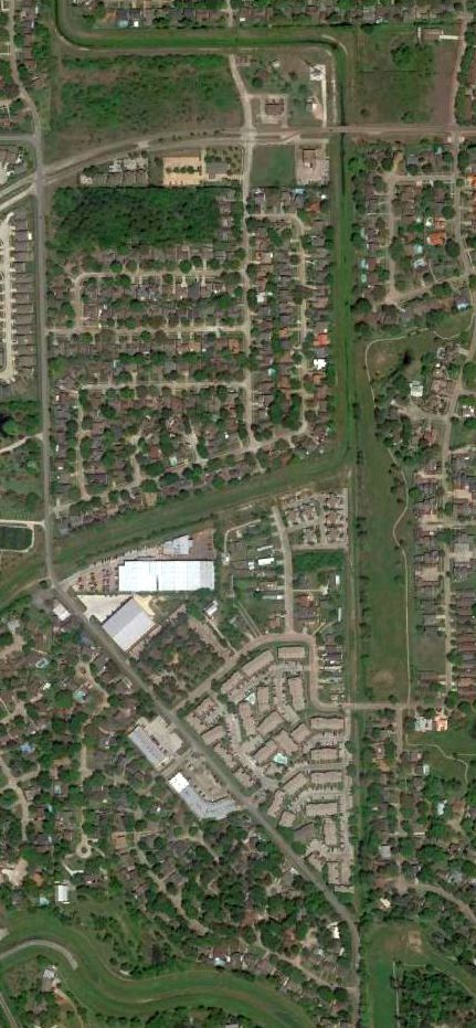
A 2014 aerial view showed no recognizable trace remaining of Collier Airport.
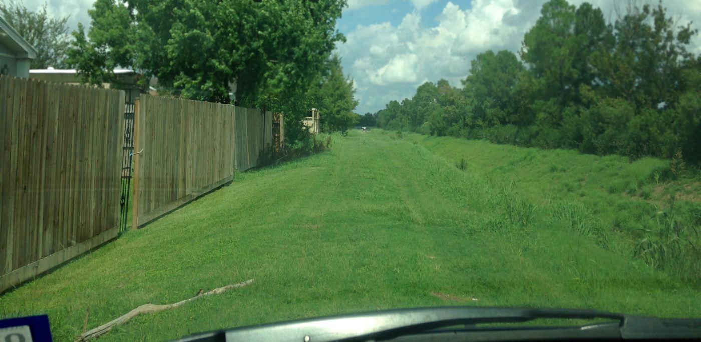
A 9/17/15 photo by Dale Muenzler of the remains of a Collier Airport turf taxiway.
Dale reported, “If one follows Long Leaf Drive off of Albonson, right before a drainage ditch,
turn North/left on a small driveway and a portion of the old turf taxiway is visible.
Most of the remaining runway is now a drainage ditch for Harris County’s Flood Control.
Come to think of it, how convenient would it be to have a straight & level site for a ditch.”
As of 2015, street maps label the site of Collier Airport as the Inwood Club Estates housing development,
with Bayou Forest Drive passing over the alignment of the former runway.
Thanks to Dale Muenzler for pointing out this airfield.
____________________________________________________
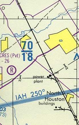
Flying Acres Airfield, Houston, TX
29.95, -95.57 (Northwest of Downtown Houston, TX)
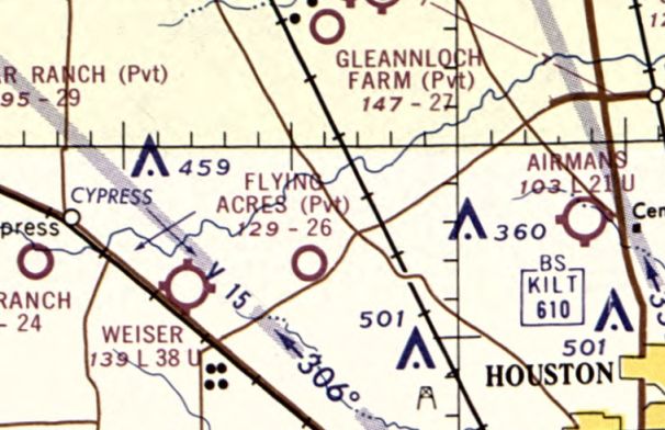
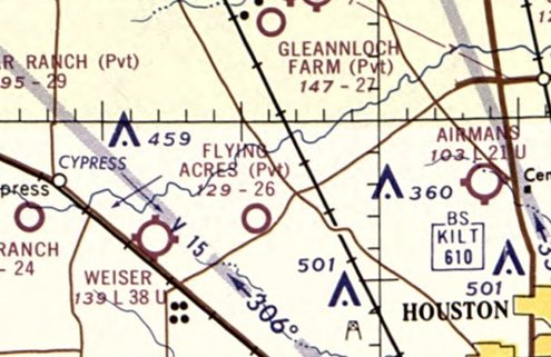
Flying Acres Airfield, as depicted on the April 1965 Beaumont Sectional Chart.
This fly-in community was evidently established at some point between 1961-65,
as it was not yet depicted on a 1953 aerial photo
nor on the February 1961 Beaumont Sectional Chart.
The earliest depiction which has been located of Flying Acres Airfield was on the April 1965 Beaumont Sectional Chart.
It depicted Flying Acres as a private airfield having a 2,600' unpaved runway.
Steve Durrett recalled, “There was a fly-in housing development called Flying Acres. I used to go by this place as a kid in the 1960s.”
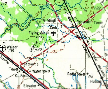
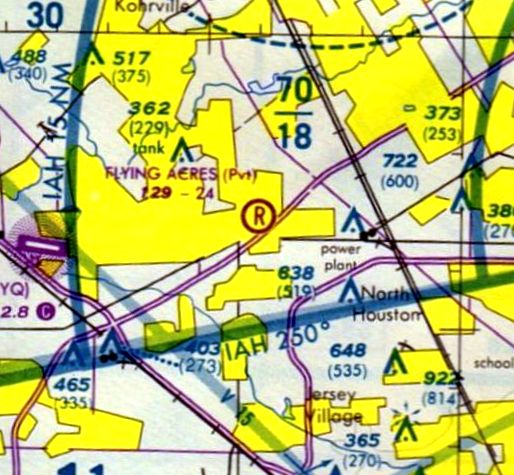
Flying Acres Airfield, as depicted on the 1968 USGS topo map.
Dale Muenzler recalled, “My wife & I flew into Flying Acres once just to look around & exercise our freedom to do so.”
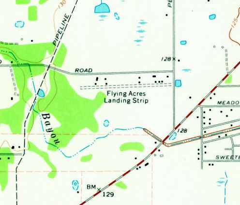
The 1970 USGS topo map depicted “Flying Acres Landing Strip” as an unpaved east/west runway with a smattering of small buildings along the north side.
Note how little development surrounded the airfield in the early 1970s.
The earliest photo which has been located of Flying Acres Airfield was a 1977 USGS aerial view looking northeast,
showing an unpaved east/west runway with some homes & hangars along the north side.
The 1977 Houston Terminal Aeronautical Chart (unfortunately cropped)
depicted Flying Acres as a private airfield having a 2,600' unpaved runway.
The last aeronautical chart depiction which has been located of Flying Acres Airfield was on the 1992 Houston Terminal Aeronautical Chart.
Flying Acres' published runway length had decreased slightly to 2,400'.

The 1995 USGS topo map still depicted depicted Flying Acres as an unpaved “Landing Strip”,
but no longer with a name, possibly indicating the airfield had been closed by that point.
Flying Acres Airfield was evidently closed (officially at least) at some point between 1992-2004,
as it was no longer depicted on the 2004 Houston Terminal Aeronautical Chart (courtesy of Jonathan Westerling).

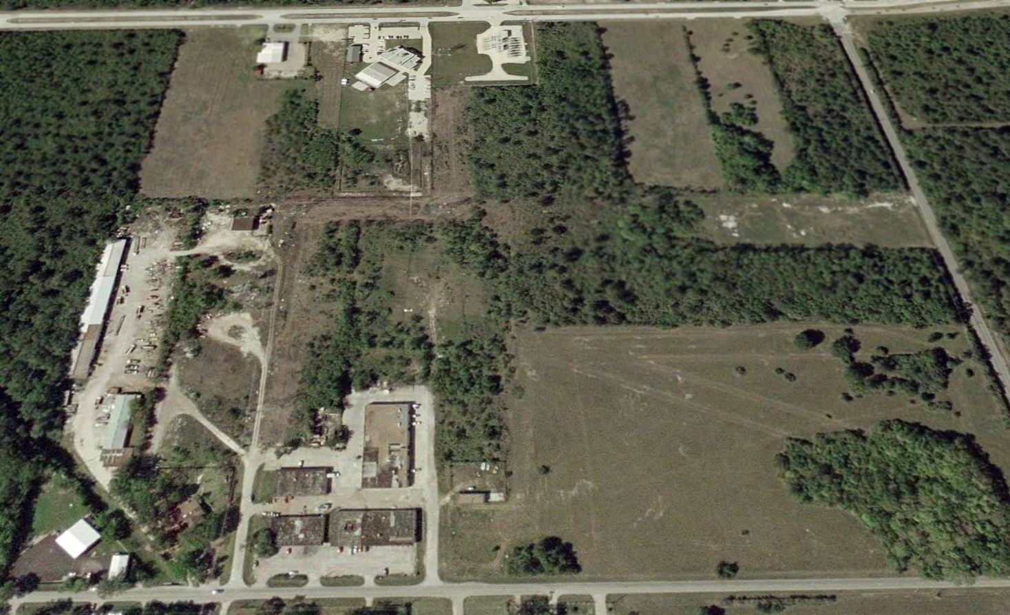
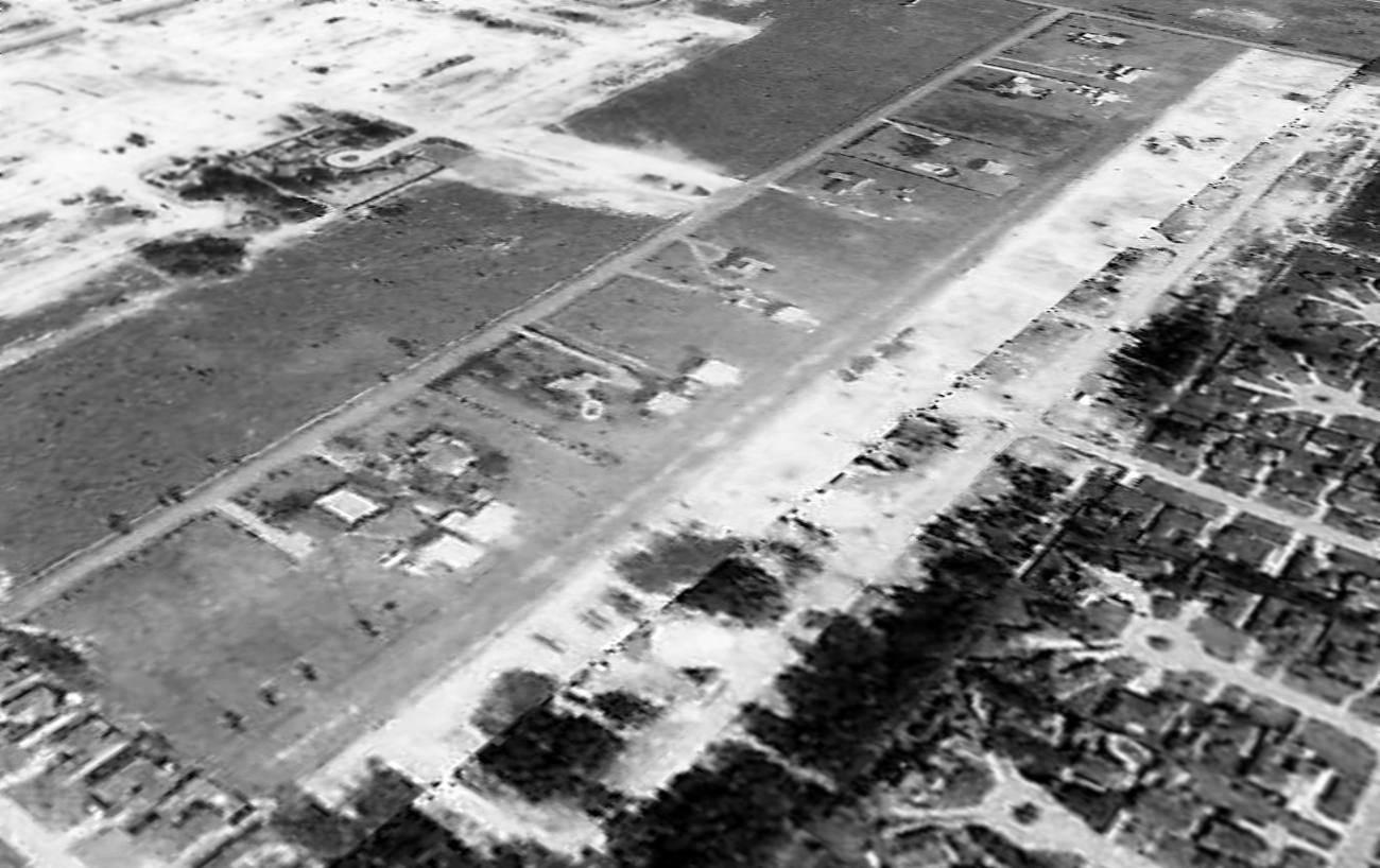
A circa 2010 aerial view looking north at a hangar along the north side of the Flying Acres Airfield runway.

A 2014 aerial view looking northeast showed the Flying Acres Airfield runway remained clear, and several hangars remained along the north side,
but there was no sign of any recent aviation usage.
Steve Durrett reported in 2015, “The last time I drove by there, it didn't appear to be in usable shape.”
Dale Muenzler reported in 2015, “Flying Acres... I just went by there & the trees have grown so large it would be difficult to land or take off from that one.”
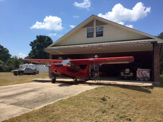
A 6/18/16 photo by Will Denne of the last plane still being flown from Flying Acres Airfield – a Citabria.
Bill reported, “We met an older man who was washing his plane.
We talked to him about the airstrip, and he said he's been there since the 1990s, and he is the only one who is still flying out of there.”
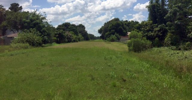
A 6/18/16 photo by Will Denne looking along Flying Acres Airfield's grass runway. Bill reported, “We walked the length of the runway.”

An 8/15/25 photo by Scott Schilling looking along the former Flying Acres Airfield runway. Scott reported, “Flying Acres sadly appears to no longer be used. I walked the length of it.
The runway is overgrown in some places, mowed in other spots, seemingly by individual homeowners backing up to it.”

An 8/15/25 photo by Scott Schilling of a former Flying Acres Airfield hangar, “fenced off & used for storage.”
Flying Acres Airfield is located southwest of the intersection of Lou Edd Road & Perry Road.
Thanks to Steve Durrett for pointing out this airfield.
____________________________________________________
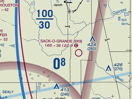
Harbican Airport / Sack-O-Grande Acroport (9X9), Katy, TX
29.91, -95.83 (Northwest of Houston, TX)
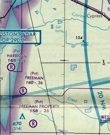
Harbican Airport, as depicted on the February 1989 Houston Terminal Chart (courtesy of Stu Sibitzky).
According to the David Mafridge Airshows website, Harbican Airport was in operation for 25 years (opening circa 1971).
However, no airfield at this location was depicted on USGS topo maps from 1971-92,
and a 1973 USGS aerial photo did not yet depict any runway at this location.
The earliest depiction which has been located of Harbican Airport was a 1981 aerial view,
which depicted 8 single-engine aircraft parked along the north side of an east/west grass runway,
with a few small buildings on the northwest side.
The earliest aeronautical chart depiction which has been located of Harbican Airport was on the February 1989 Houston Terminal Chart (courtesy of Stu Sibitzky).
It depicted Harbican as a private airfield having a 3,900' unpaved runway.
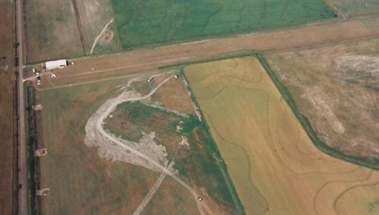
The earliest photo which is available of Harbican Airport was a September 1993 aerial view looking north by John Rich.
It depicted Harbican as having an unpaved east/west runway, with 1 single-engine taildragger parked near a small hangar on the northwest side.
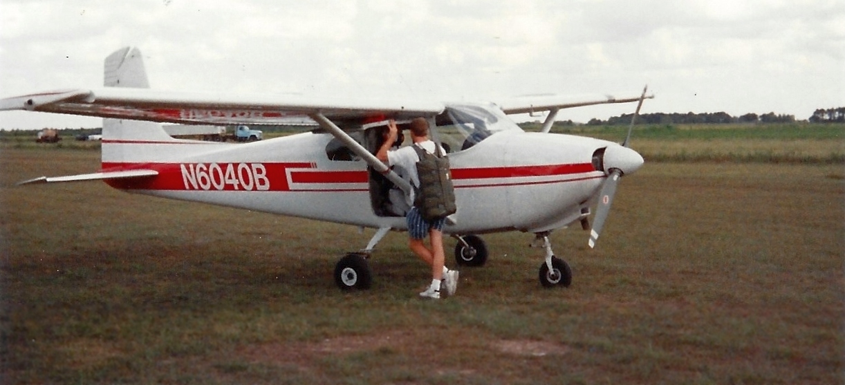
A September 1993 photo by John Rich of a Cessna 182 used for skydiving by “Skydive West Houston at Harbican Field, run by Pat Thysen.”
According to the David Mafridge Airshows website, David Mafrige purchased Harbican Airport in 1996 & renamed it Sack-O-Grande Acroport.
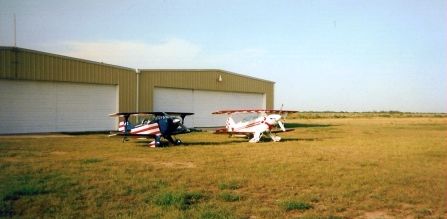
A 1996 photo of the first aircraft to land at Sack-O-Grande, 2 unidentified aerobatic biplanes shown in front of 2 hangars.
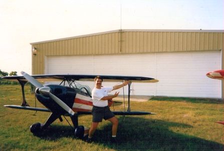
A 1996 photo of Andy “Airshow” Miller in front of an aerobatic biplane at Sack-O-Grande Acroport.
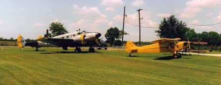
A circa late 1990s photo of a Beech 18 & a Piper J-3 Cub at Sack-O-Grande Acroport.

The earliest aeronautical chart depiction which has been located of Sack-O-Grande
was on the March 1999 Houston Sectional Chart (courtesy of Ron Plante).
It depicted Sack-O-Grande as a private airfield having a 3,900' unpaved runway.
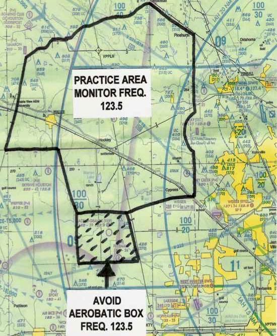
A circa 2003 West Houston Practice Area Chart (courtesy of Mike Meadows) depicted the Sack-O-Grande aerobatic box.
According to the David Mafridge Airshows website, Sack-O-Grande was operated as a private airport
until it changed it's status to public as of 11/1/03.
The website said, “The airport sits on approximately 20 acres with a grass runway length of 3,900'.
The airport also holds waivered airspace for an aerobatic box
thus being the primary practice facility for many of the aerobatic pilots in the central Texas.”
As of 2014, the FAA Airport Facility Directory data for Sack-O-Grande described it
As having a single 3,950' turf runway 9/27, with “Numerous large holes throughout the runway.”
The owner was listed as Sack-O-Grande Inc., and the manager as Troy Maxwell.
Mike Meadows reported in 2014, “Up until recently it was owned by David Mafrige for 7 years.
David was an aerobatic competitor & airshow performer.
When he owned the airport, it held an airspace waiver for an aerobatic box from the surface to 3,500'.
The lowering of the Houston [Class] Bravo airspace that affected us in 2003
lowered his airspace to 2,500' rendering it useless for aerobatics.”
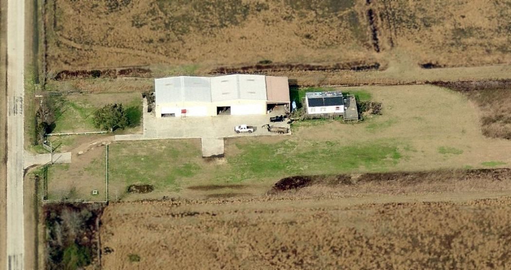
A circa 2012 aerial view looking north showed no sign of any aviation activity at Sack-O-Grande Acroport,
although the hangars & runway remained otherwise intact.
The 2014 Houston Terminal Chart depicted Sack-O-Grande as a public-use airport having a 3,900' unpaved runway.
Unfortunately, a 2014 NOTAM (courtesy of Mike Meadows) announced the closure of Sack-O-Grande Acroport.
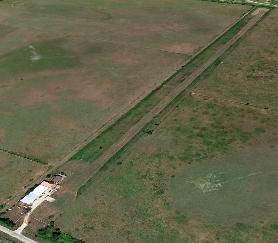
A 5/2/14 aerial view looking northeast showed no sign of any aviation activity at Sack-O-Grande Acroport,
although the hangars & runway remained otherwise intact.
Sack-O-Grande Acroport is located northeast of the intersection of Sharp Road & Katy Hockley Road.
Thanks to Mike Meadows for pointing out the closure of this airfield.
____________________________________________________
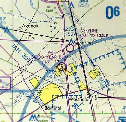
Goodyear Blimp Airfield, Spring, TX
30.06, -95.43 (Northwest of Houston, TX)

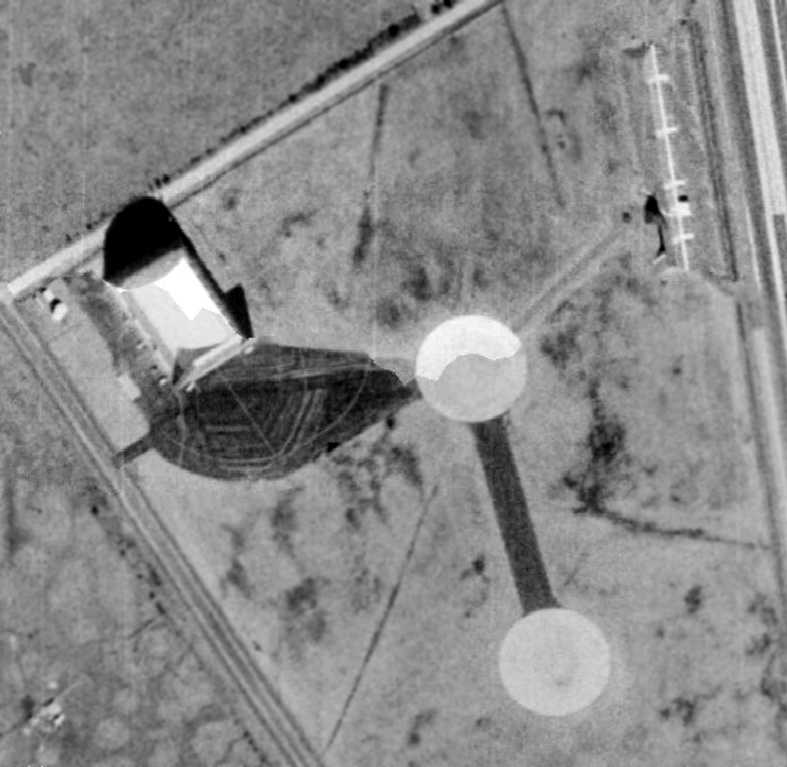
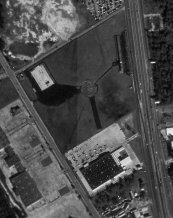
A 10/1/69 USGS aerial view of the Goodyear Blimp Airfield.
This blimp airfield was evidently established at some point between 1967-69,
as nothing airfield-related was yet recognizable on a 1964 aerial photo (courtesy of David Owens),
and no airfield was yet depicted at this location on the September 1967 Beaumont Sectional Chart.
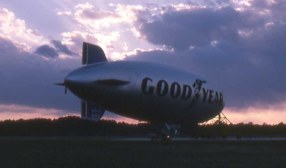
Starting in 1969, the Goodyear airship America was based at this facility in Spring, TX.
During its travels the blimp's night signs were used to display advertising messages,
and its TV camera filmed many sporting & public events.
The earliest depiction of the airfield which has been located was a 10/1/69 USGS aerial view.
It depicted a blimp hangar at the west corner & 2 blimp mooring circles.
A 1973 aerial view depicted the Goodyear Blimp Airfield as having a blimp hangar at the west corner & 2 blimp mooring circles.
Inexplicably, no airfield was yet depicted at this location on the March 1973 Houston Sectional Chart (according to Chris Kennedy).
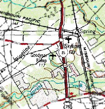
The 1976 USGS topo map labeled the airfield as “Goodyear Blimp”.

A 2/1/76 USGS aerial view of the Goodyear Blimp Airfield depicted a Goodyear Blimp moored at the southern blimp mooring circle.
The earliest aeronautical chart depiction which has been located of the Goodyear Blimp Airfield
was on the September 1977 Houston Terminal Area Chart (courtesy of Chris Kennedy).
It depicted “Good Year Blimp” as a private airfield with a 1,700' unpaved runway.
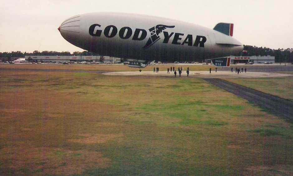
The earliest photo which has been located showing a blimp at the Goodyear Spring facility
was a 1979 photo by Rick Oleson of a Goodyear Blimp moored at the field.
Rick recalled, “I lived in Houston from 1978-82 & visited the base a number of times.
They built a new blimp in Spring - I think it was to be based in Atlanta -
and when it was finished it flew alongside the Houston blimp around the city for trials before being delivered.”
The August 1981 Houston Sectional Chart (courtesy of Steve Cruse) depicted “Goodyear Blimp” as a private airfield.
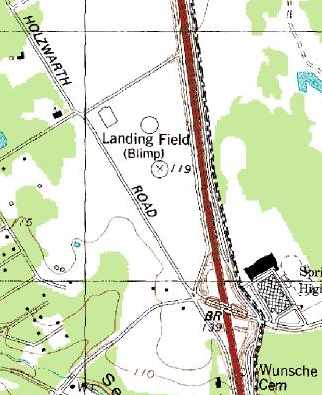
The 1982 USGS topo map depicted the “Landing Field (Blimp)” as having 2 blimp mooring circles,
along with a single hangar on the northwest side of the field.
The August 1985 Houston Sectional Chart (according to Chris Kennedy) depicted “Goodyear Blimp” as a private airfield.
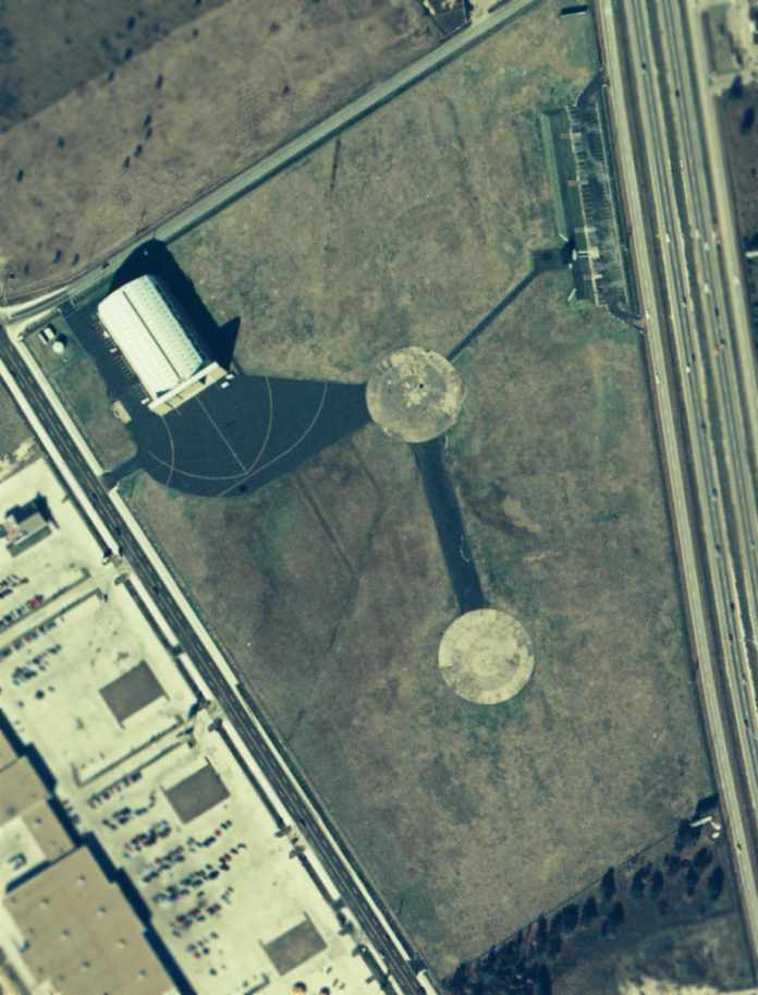
An 11/28/87 aerial view of the Goodyear Blimp field (courtesy of David Owens) showed the blimp hangar in the northwest corner,
two paved blimp mooring circles in the center of the field, and a viewing area at the northeast corner of the property.
Eric Bauer reported, “I work about 1 mile from the Goodyear Blimp site in Spring,
and used to routinely watch the blimp fly over my office at low altitude as it was preparing to land.”
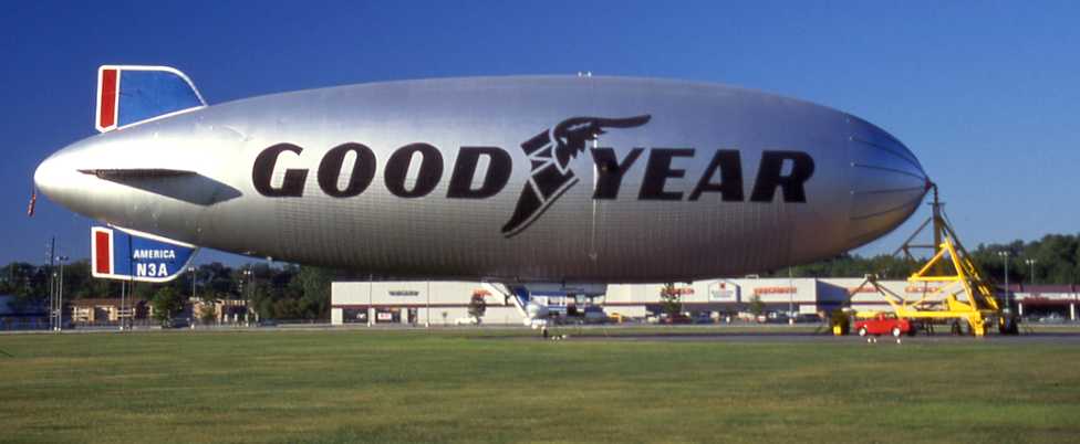
An undated photo looking west at the Goodyear Blimp America moored at the Spring Blimp Base.
A circa 1991-93 photo by David Handley (courtesy of Brian Handley) of a Goodyear Blimp taking off from the Spring Blimp Field.
Brian recalled, “My Dad was taking these photos because the blimp base was scheduled to be closed.
There was a viewing stand on the east side of the interstate (west side of the grounds).
In most of the shots you can see the netting of lights on the side of the balloon that was used to show advertising at night.
As a kid, I used to run outside at night to see the blimp flying in the sky with the light-up scrolling banners.”
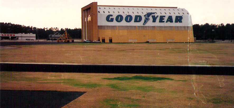
A circa 1991-93 photo by David Handley (courtesy of Brian Handley) of the Goodyear Blimp hangar at the Spring Blimp Field.

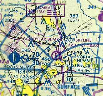
The January 1992 Houston Terminal Area Chart depicted “Goodyear Airship Operations” as a private airfield.
In 1992, the home base of the Goodyear airship America was moved to Akron, OH.
The last photo which has been located still showing the Goodyear Blimp hangar was a 1992 aerial view.
However, the February 1993 Houston Sectional Chart (courtesy of Steve Cruse)
continued to depict “Goodyear Airship Operations” as a private airfield.
According to Greg Havens, “The old blimp base... was closed around 1993.
One of the last occupants was Genesis tuning up & preparing for a tour. We could hear them whenever we drove by.”
The 1995 USGS aerial photo depicted that a Home Depot & its parking lot had been built over the location of the blimp mooring circle on the southern part of the field,
and the blimp hangar on the northwest corner of the field had been removed at some point between 1991-95.
Other portions of the blimp field still remained intact, including the blimp mooring circle in the center of the field.
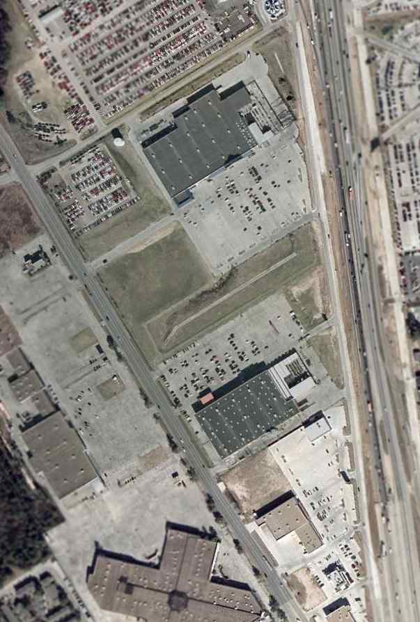
A 2002 USGS aerial photo showed most of the Goodyear Blimp airfield had been built over,
but the hangar foundation remained on the western corner (reused as a parking lot).
The Goodyear Airship facility was no longer depicted on the 2004 Houston Terminal Area Chart (courtesy of Jonathan Westerling).
Greg Havens reported in 2006 that the site of the former blimp base “is now a Home Depot & a Lowe's hardware store.”

A 2022 aerial view looking northeast showed the hangar foundation remained on the western corner of the Goodyear Blimp airfield site (bottom-left of picture).

A 2022 aerial view looking northwest at the hangar foundation on the western corner of the Goodyear Blimp airfield site.
Former Goodyear Blimp pilot Matthew Lussier observed, “That's the foundation of the old hangar. There are no longer parked on it, so now it's more apparent.
You can even still see the railroad tracks on the south part of that pad that took the weight of the massive hangar doors. Still evidence! It's not completely white-washed.”
The site of the Goodyear Blimp Airfield is located southwest of the intersection of Interstate 45 & Meadow Edge Lane.
____________________________________________________
Or if you prefer to contact me directly concerning a contribution (for a mailing address to send a check),
please contact me at: paulandterryfreeman@gmail.com
If you enjoy this web site, please support it with a financial contribution.
____________________________________________________
This site covers airfields in all 50 states.