Abandoned & Little-Known Airfields:
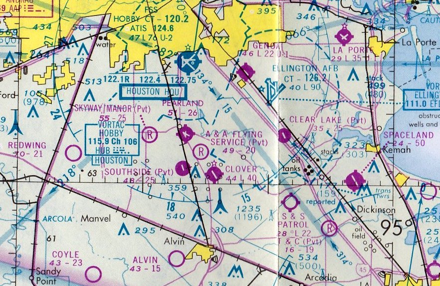
Texas: Southeastern Houston area
© 2002, © 2026 by Paul Freeman. Revised 2/22/26.
This site covers airfields in all 50 states: Click here for the site's main menu.
____________________________________________________
Please consider a financial contribution to support the continued growth & operation of this site.
Alvin Airport (revised 6/8/23) - Clear Lake Metro Port (revised 2/22/26) - Davis Aux AAF #3 (revised 10/19/19) - Genoa Airport (revised 5/10/22) - Gulf Coast Airport (revised 6/8/23) - Hitchcock NAS (revised 2/22/26)
Kami-Kazi Airport (revised 6/8/23) - Pearland Municipal Airport (revised 4/21/22) - Red Bluff Auxiliary Army Airfield #1 (revised 10/19/19)
S & S Patrol Field (revised 8/25/18) - Spaceland Airport / Houston Gulf Airport (revised 8/4/23)
____________________________________________________
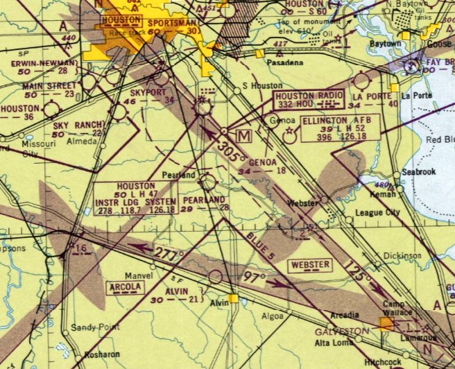
29.449, -95.291 (Southeast of Houston, TX)
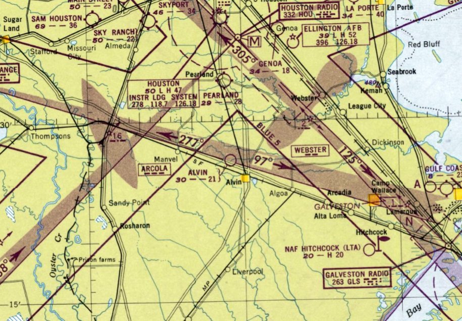
Alvin Airport, as depicted on the August 1948 San Antonio Sectional Chart.
This small general aviation airport was evidently established at some point between 1947-48,
as it was not yet depicted on the July 1947 San Antonio Sectional Chart.
The earliest depiction which has been located of Alvin Airport was on the August 1948 San Antonio Sectional Chart.
It depicted Alvin Airport as having a 2,100' unpaved runway.
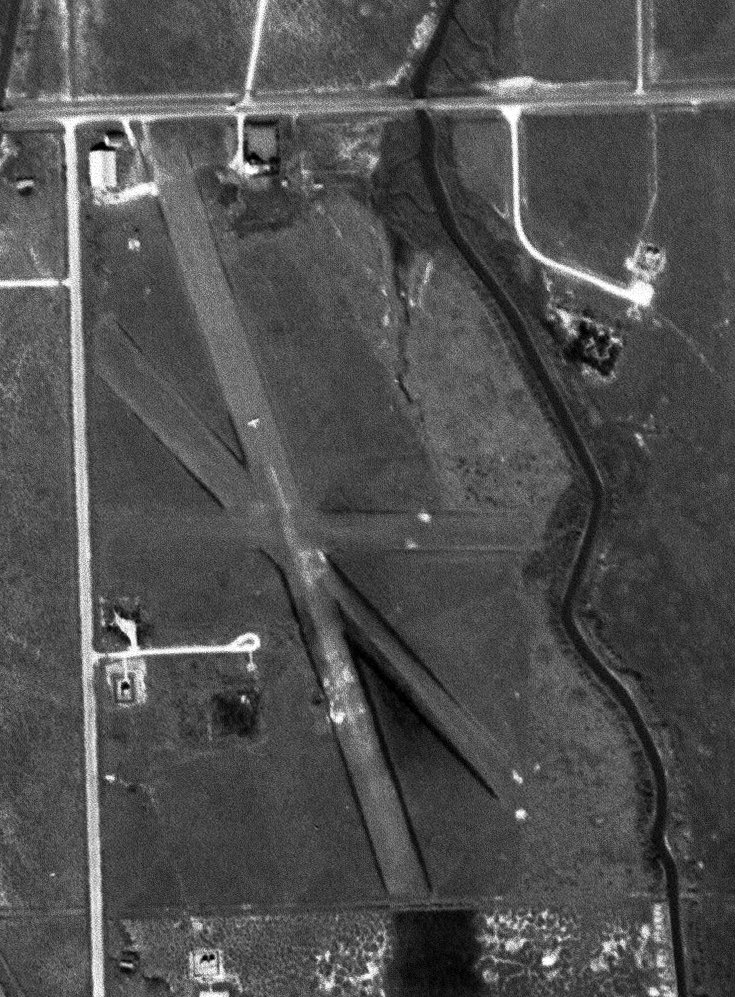
The earliest photo which has been located of Alvin Airport was a 1955 aerial view.
It depicted Alvin Airport as 2 unpaved runways in an “X” shape, with 4 light single-engine planes parked near a few small small buildings on the north side.
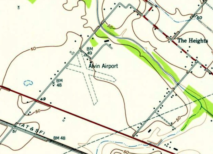
The earliest topo map depiction which has been located of Alvin Airport was on the 1956 USGS topo map.
It depicted Alvin Airport as 2 unpaved runways in an “X” shape, with a small small buildings on the north side.
In 1959, a different Alvin Airpark was established a mile the south, on the opposite side of Highway 6.
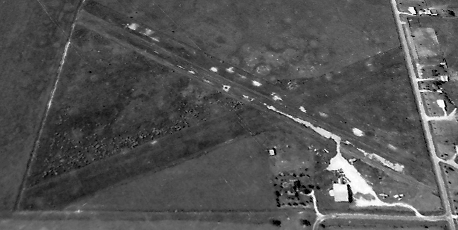
The only photo which is available of Alvin Airport was a 1965 aerial view looking southwest.
It depicted Alvin Airport as 2 unpaved runways in an “X” shape, with 2 light single-engine planes parked near a small small hangar on the north side.
Alvin Airport was evidently closed (for reasons unknown) at some point between 1965-69,
as a 1969 aerial view showed the runways remained clear, but the hangar had been removed & the field was devoid of aircraft.
The 1970 USGS topo map no longer depicted anything at the site of Alvin Airport.
According to a TX Commission on Environmental Quality report, “The McNabb Flying Service state Superfund site is located 1.5 miles northwest of the city of Alvin,
approximately 1 mile east of State Highway 6, at the intersection of Brazoria County Roads 146 & 539.
The site was identified as a potential hazardous waste site by the EPA in October 1984 from TX Department of Agriculture files.
The site had been used as an aerial pesticide applicator service. A preliminary assessment in January 1985 noted that the site had been inactive for more than 10 years.”
2013 photo showed the former Alvin Airport hangars as overgrown.
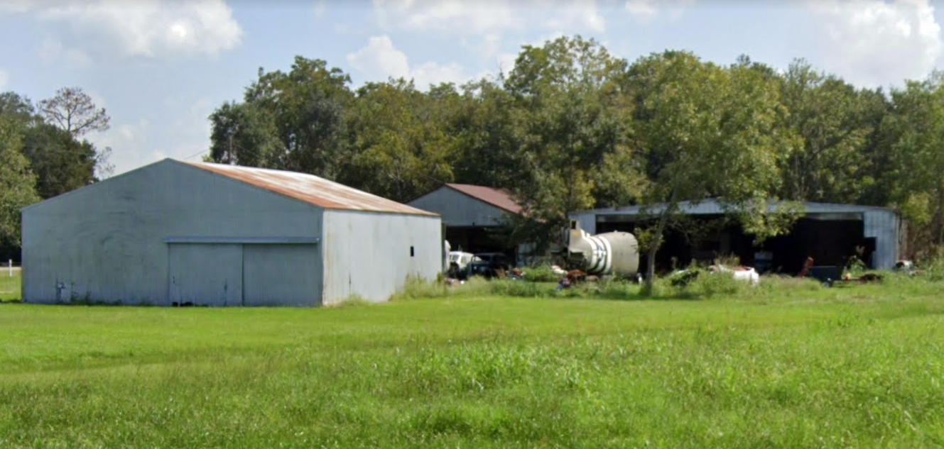
A 2019 photo looking east showed area around the former Alvin Airport hangars as having been cleared, with a military aircraft rear fuselage (a C-47) having appeared.
A sign indicated the property was being reused as the “Legacy Events Center”.
A 2021 photo looking east at the former Alvin Airport hangars (courtesy of Jonathan Butcher) showed the C-47 fuselage had been removed, but a North American T-28 Trojan had appeared, sans propeller.
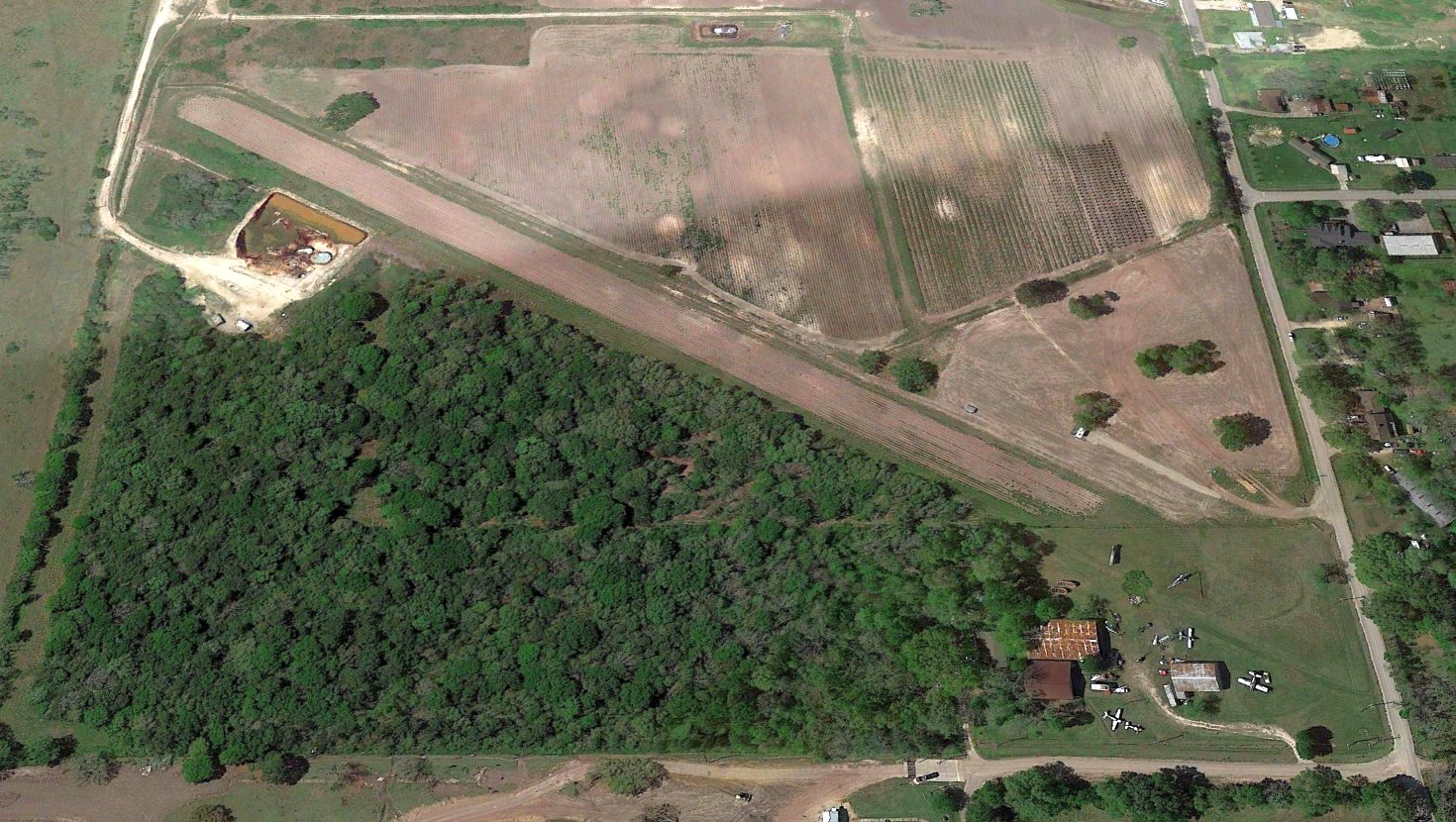
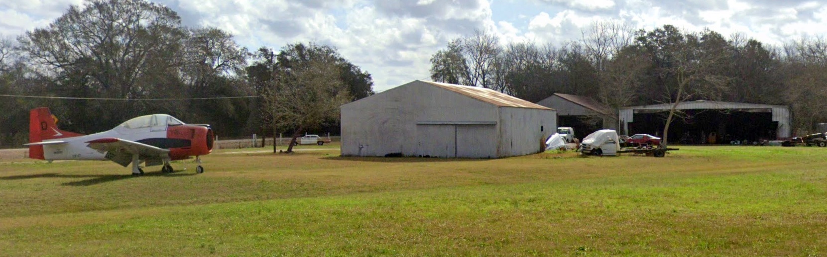
A 2022 aerial view looking southwest showed the former Alvin Airport, with a collection of non-flying aircraft on the north corner.
As of 2022, street maps still label the Alvin Airport site as “Old McNabb Airfield”.
Thanks to Jonathan Butcher for pointing out this airfield.
____________________________________________________
Gulf Coast Airport, Texas City, TX
29.405, -94.949 (Southeast of Houston, TX)
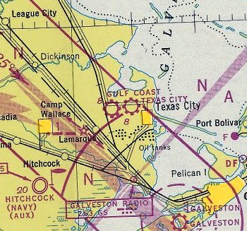
Gulf Coast Airport, as depicted on the January 1947 San Antonio Sectional Chart.
This small general aviation airport was evidently established at some point between 1945-47,
as it was not yet depicted on the August 1945 San Antonio Sectional Chart.
The earliest depiction which has been located of Gulf Coast Airport was on the January 1947 San Antonio Sectional Chart.
Note that it also depicted the Texas City Airport less than a mile to the east.
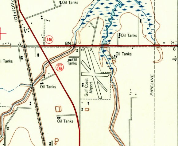
The 1954 USGS topo map depicted Gulf Coast Airport
as having 3 runways & a few small buildings on the northwest & southwest sides.
The only photo which has been located showing Gulf Coast Airport in operation was a 1/24/55 USGS aerial view.
It depicted Gulf Coast Airport as having 3 grass runways & a few small buildings on the northwest side.
A light single-engine aircraft was visible on the northwest/southeast runway.
Jeff Moralez recalled, “I grew up in the Moses Lake area which is the north side of Texas City.
This is where I took my first flight at age 11. Civil Air Patrol was there also.
There was a grass strip with some old Quonset-hut style hangars where introductory flights were $5.
About 50 years ago [circa 1968] two friends & I rode our bicycles to take one of the $5 introductory rides.”
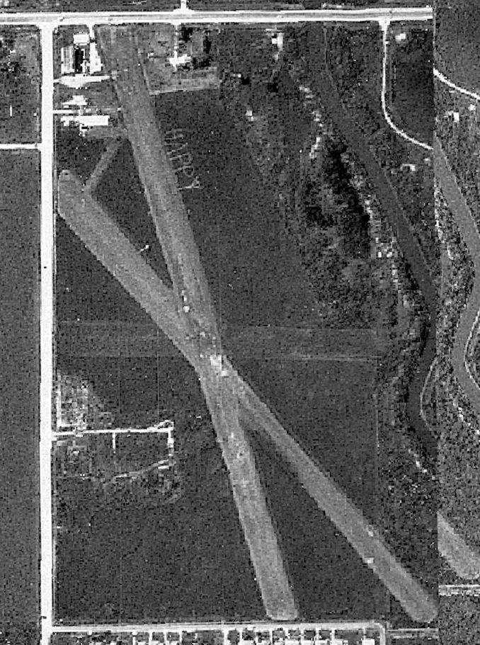
At 1969 USGS aerial photo (courtesy of Av Edidin) showed Gulf Coast Airport remained intact, but there were no aircraft visible on the field.
A 300' long word “HAPPY” had been cut into the grass adjacent to the east side of the northwest/southeast runway.
Gulf Coast Airport may have been closed by 1974, as it was no longer depicted on the 1974 USGS topo map.
The last aeronautical chart depiction which has been located of Gulf Coast Airport was on the February 1975 Houston Sectional Chart.
It depicted Gulf Coast as having a 2,300' unpaved runway.
Gulf Coast Airport was evidently closed (for reasons unknown) at some point between 1975-87,
as a 1987 aerial photo showed showed several streets & houses had been built over the site & the hangars had been removed,
but traces of the runways were still recognizable.
A 2018 aerial view looking southeast showed no trace remaining of Gulf Coast Airport.
The site of Gulf Coast Airport is located southeast of the intersection of Route 197 & 36th Street.
Thanks to Jeff Moralez for pointing out this airfield.
____________________________________________________
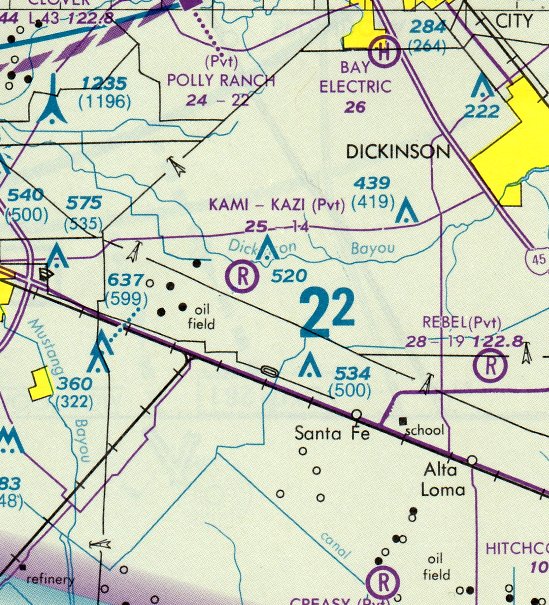
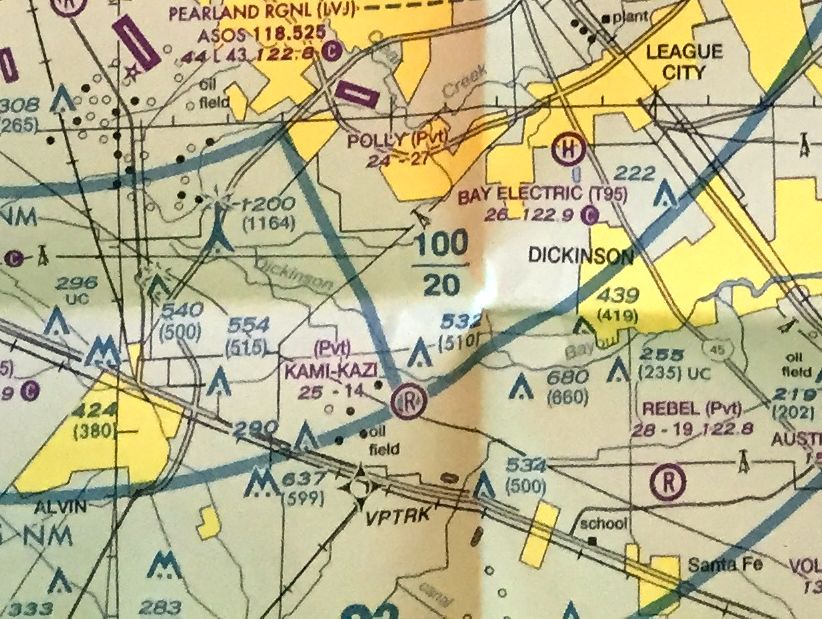
Kami-Kazi Airport (5TA7), Santa Fe, TX
29.421, -95.159 (Southeast of Houston, TX)
Kami-Kazi Airport, as depicted on a 1989 aerial view looking northwest.
This small private airfield was evidently established at some point between 1969-81,
as it was not yet depicted on a 1969 aerial photo nor on the 1977 USGS topo map.
According to Kami-Kazi Airport's FAA Airport/Facility Directory data, it was established in February 1981.
The earliest depiction which has been located of Kami-Kazi Airport was a 1989 aerial photo.
It depicted Kami-Kazi as having an grass northeast/southwest runway, with a few small buildings (hangars?) on the south side.
The earliest aeronautical chart depiction which has been located of Kami-Kazi Airport
was on the February 1989 Houston Terminal Chart (courtesy of Stu Sibitzky).
It depicted Kami-Kazi as a private airfield having a mere 1,400' unpaved runway.
The last aeronautical chart depiction which has been located of Kami-Kazi Airport was on the March 2009 Houston Terminal Aeronautical Chart.
It depicted Kami-Kazi as a private airfield having a 1,400' unpaved runway.
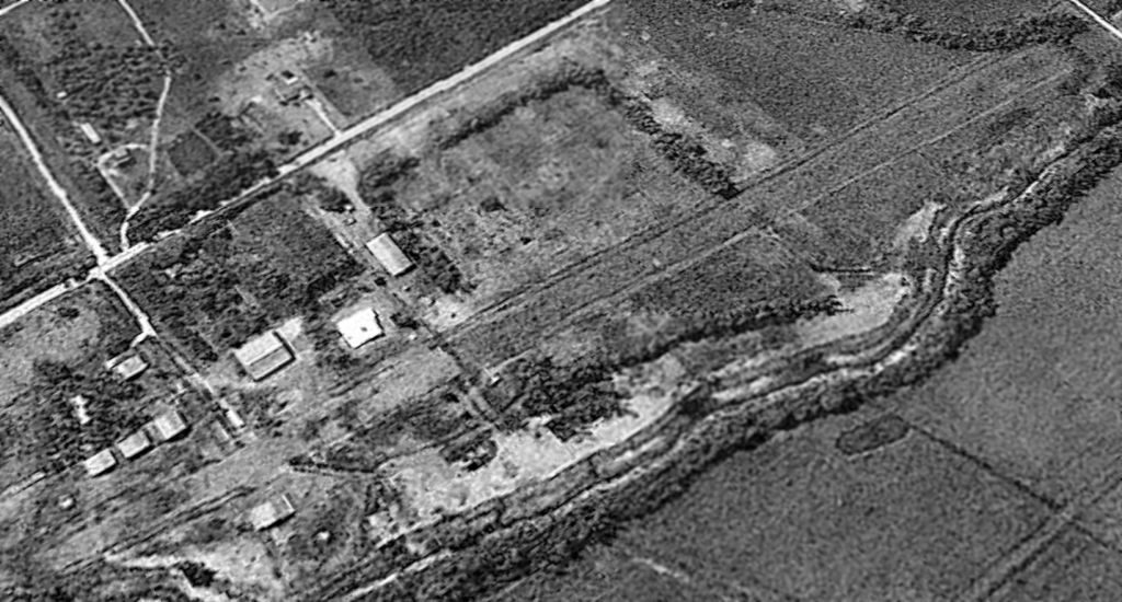
A 2015 aerial view looking northwest showed that the Kami-Kazi Airport runway remained mostly clear, but trees had grown on its north end,
and a building had been constructed over its south end.
Kami-Kazi Airport was not depicted on the 2016 Houston Terminal Aeronautical Chart.
However it was still listed in the FAA Airport/Facility Directory as of 2016.
It was described as having a 1,400' turf Runway 18/36, and the owner & manager were listed as James Entrekin.
Patrick A. reported on 5/9/16, “Kami-Kazi Airport... I drove by it today & it had signs up saying it can be subdivided into 9 country style lots with a barn.”
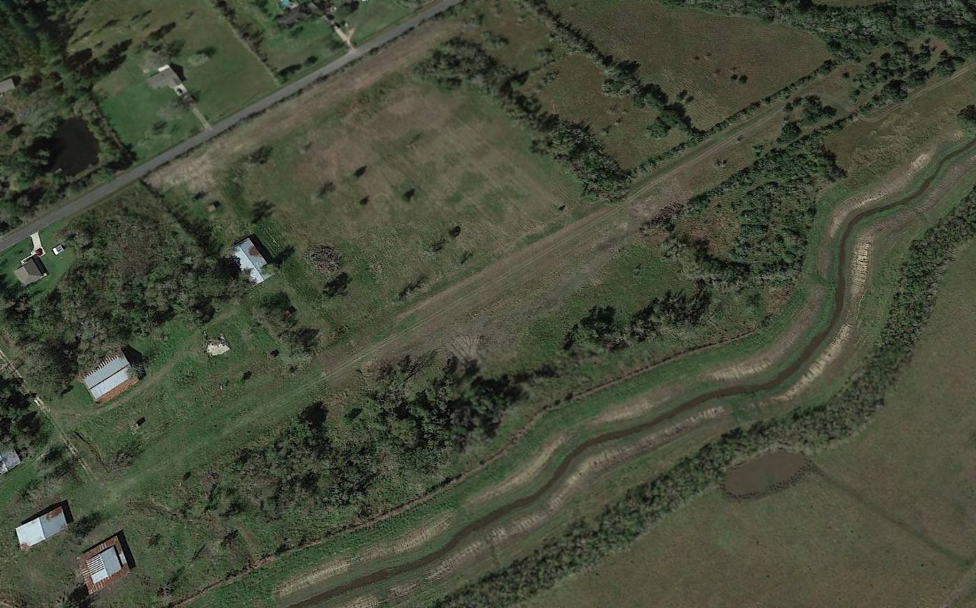
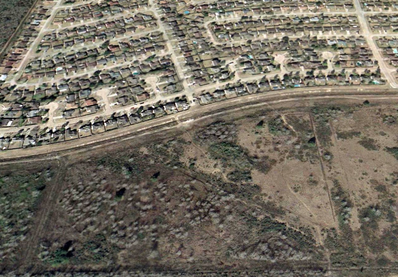
A 2022 aerial view looking northwest showed that houses had been built over the Kami-Kazi Airport site, with only faint traces remaining recognizable of the former runway.
Kami-Kazi Airport is located east of the intersection of Dahlstrom Road & Rymal Road.
Thanks to Patrick A. for pointing out this airfield.
____________________________________________________
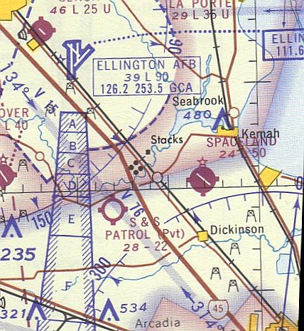
Red Bluff Auxiliary Army Airfield #1, Seabrook, TX
29.6, -95.02 (Southeast of Houston, TX)
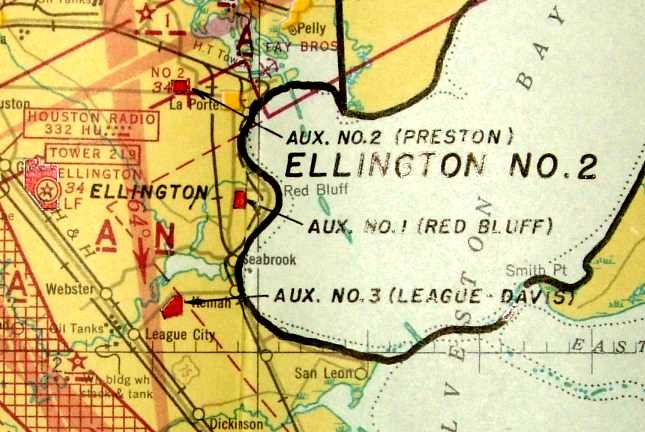
“Aux. #1 (Red Bluff)", as depicted on an annotated January 1944 San Antonio Sectional Chart (courtesy of Ron Plante).
Photo of the airfield while in use has not been located.
This former airfield was established during WW2 as one of 3 auxiliary airfields used to support flight training operations at nearby Ellington Army Airfield.
No airfield at this location was yet depicted on the June 1943 San Antonio Sectional Chart (courtesy of Richard Doehring).
A 5/15/43 AAF list of airfields of the Gulf Coast Training Center (courtesy of Ron Plante) described “Red Bluff” as having 3 shell-sand 4,000' runways.
The earliest depiction of the field which has been located was on an annotated January 1944 San Antonio Sectional Chart (courtesy of Ron Plante).
It labeled the field as “Aux. #1 (Red Bluff)".
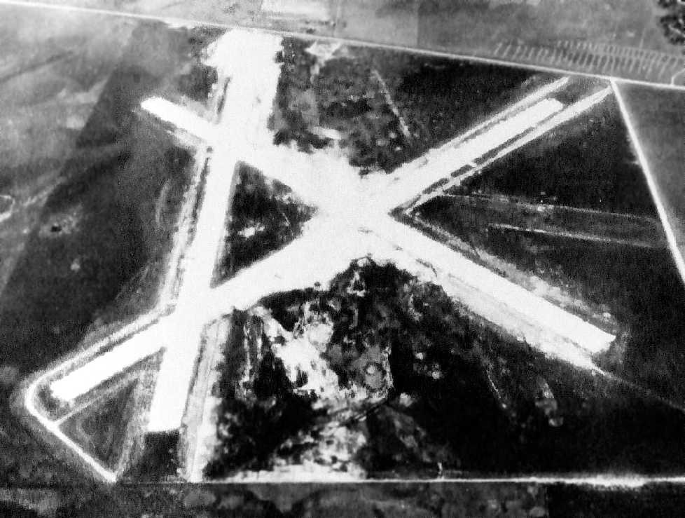
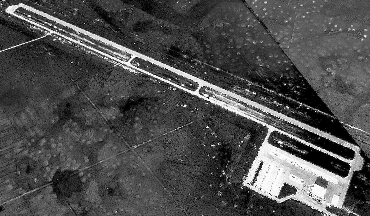
The earliest photo which has been located of the Red Bluff airfield was a 2/29/44 aerial view looking west (courtesy of Ron Plante).
The field consisted of 3 runways. There did not appear to be any buildings.
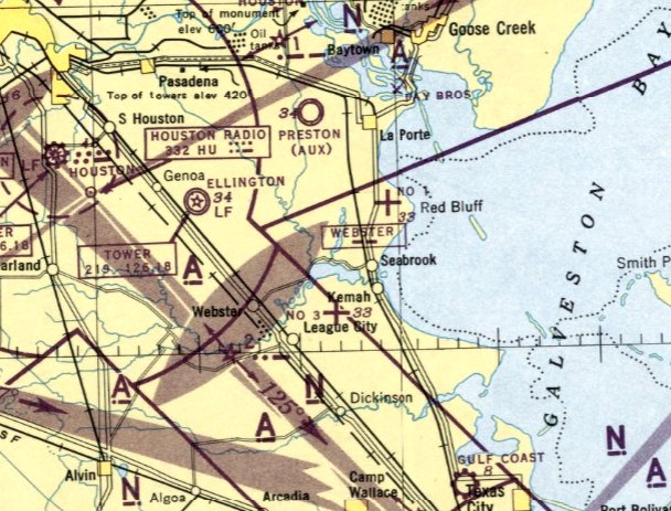
The last aeronautical chart depiction of Red Bluff #1 which has been located was on the January 1946 San Antonio Sectional Chart.
It depicted "#1" as an auxiliary airfield.
Red Bluff Airfield was not at all depicted on the 1946 USGS topo map, nor on the July 1946 San Antonio Sectional Chart.
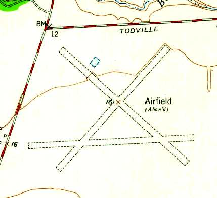
The earliest topo map depiction that has been located of Red Bluff Airfield was on the 1955 USGS topo map.
It depicted “Airfield (Aban'd)” as having 3 unpaved runways.
A 1957 aerial view depicted the 3 Red Bluff Airfield runways somewhat deteriorated but mostly intact,
although a road had crossed over the southern portion of the airfield at some point between 1944-57.
The 1969 USGS topo map depicted the abandoned Red Bluff Airfield in the same fashion as on the 1955 USGS topo map.
A 1973 aerial view depicted the Red Bluff Airfield remains in an unchanged manner as seen in 1957.
A 1978 aerial view showed that a larger road had been built through the Red Bluff Airfield site at some point between 1973-81,
and a shipping channel had been cut into the northwest corner of the airfield site.
Only the faintest traces were still recognizable of the runways.
A 1981 aerial view depicted the Red Bluff Airfield site in the same conditions.
The 1982 USGS topo map no longer depicted the Red Bluff Airfield runways at all.
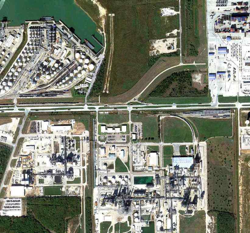
A 2002 aerial view showed that an industrial facility covered most of the Red Bluff Airfield site, and no traces remained of the former airfield.
An 11/29/11 aerial photo showed that no trace remains of the former Red Bluff Auxiliary Army Airfield #1.
The site of Red Bluff Aux #1 is located southeast of the intersection of Port Drive & Old Highway 146.
____________________________________________________
Davis Auxiliary Army Airfield #3, League City, TX
29.53, -95.06 (Southeast of Houston, TX)
“Aux. #3 (League-Davis)", as depicted on the January 1944 San Antonio Sectional Chart (courtesy of Ron Plante).
Photo of the airfield while in use has not been located.
This former airfield was established during WW2 as one of 3 auxiliary airfields
used to support flight training operations at nearby Ellington Army Airfield.
According to Muller's "Air Force Bases" Volume 1 (via Ron Plante),
"Davis Aux Fld #3" was acquired in early 1942 as an auxiliary of Ellington Army Airfield.
A 5/15/43 AAF list of airfields of the Gulf Coast Training Center (courtesy of Ron Plante)
described “League Davis” as having 3 shell-sand 4,000' runways.
No airfield at this location was yet depicted on the June 1943 San Antonio Sectional Chart (courtesy of Richard Doehring)
or on the January 1944 San Antonio Sectional Chart (according to Chris Kennedy).
The earliest depiction which has been located of Davis Aux #3 was on the January 1944 San Antonio Sectional Chart (courtesy of Ron Plante).
It labeled the field as “Aux. #3 (League-Davis)".
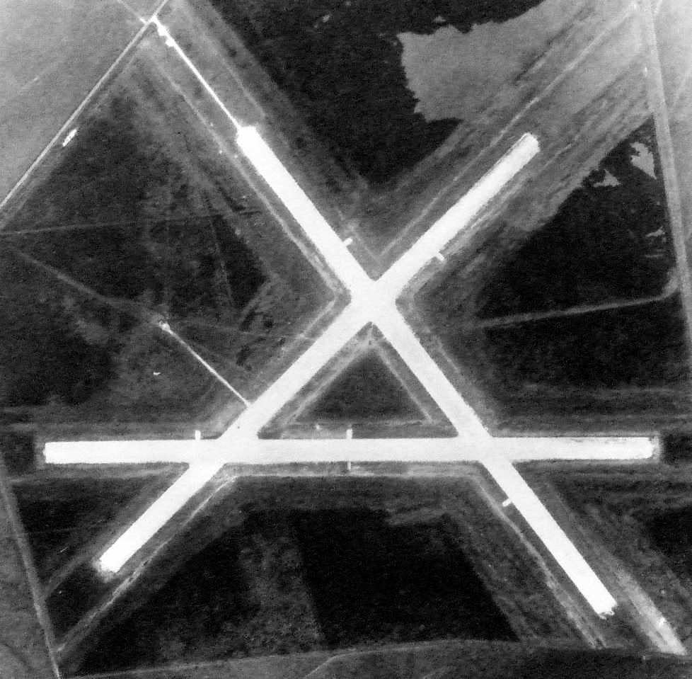
The earliest photo which has been located of the Davis airfield was a 2/29/44 aerial view (courtesy of Ron Plante).
The field consisted of 3 runways. There did not appear to be any buildings.
The last aeronautical chart depiction of Davis #3 which has been located was on the January 1946 San Antonio Sectional Chart.
It depicted "#3" as an auxiliary airfield.
The date of closure of Davis Aux #3 has not been determined,
but custody of the airfield property was assumed by the Army Division Engineers on 4/10/46 (according to Muller's "Air Force Bases" Volume 1, via Ron Plante).
Davis Aux #3 was no longer depicted at all on the January 1947 San Antonio Sectional Chart (courtesy of Ron Plante).
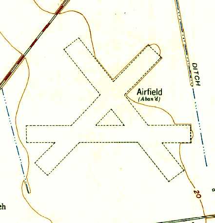
The earliest topo map depiction that has been located of the Davis Airfield was on the 1955 USGS topo map.
It depicted “Airfield (Aban'd)” as having 3 unpaved runways.
A 1957 aerial view depicted the airfield as having 3 runways, significantly deteriorated since 1944.
A 1964 aerial view showed that a canal had been cut through the northwestern portion of the airfield at some point between 1957-64.
The 1969 USGS topo map still depicted the abandoned airfield with 3 runways.
A 3/5/78 aerial view showed 3 runways of the abandoned Davis Aux #3 Army Airfield still visible.
A 1981 aerial view showed that the outline of the runways were still recognizable,
but some clearing was evident for new construction in the center of the former airfield.
The 1982 USGS topo map no longer depicted the runways at all.
At some point between 1981-87 all traces of the former airfield were removed
when the property was covered by new housing & the South Shore Harbour Country Club, as seen in a 1987 aerial photo.
A 2002 USGS aerial photo showed no trace remained of Davis Auxiliary Army Airfield #3.
The site of Davis Aux #3 is located northeast of the intersection of Route 518 & Marina Bay Drive.
____________________________________________________
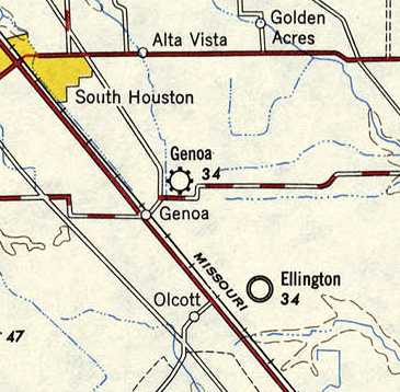
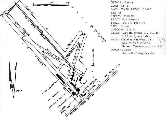
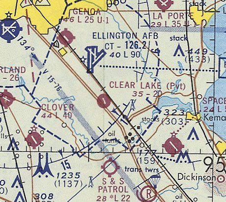
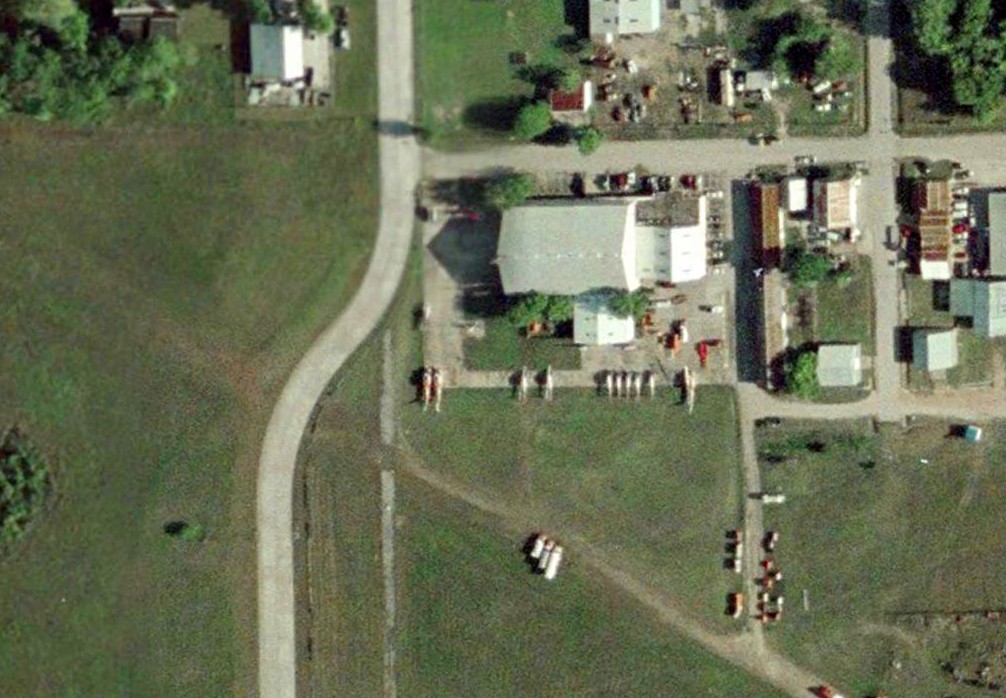
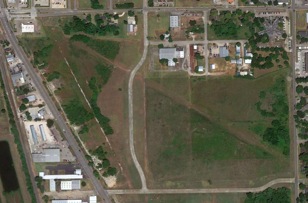
Genoa Airport (T03), Genoa, TX
29.63, -95.2 (Southeast of Houston, TX)
Genoa Airport, as depicted on the 1949 USGS topo map.
This small airport was located north of the intersection of Galveston Road & Genoa Red Bluff Road, just a mere 2 miles northwest of Ellington AFB.
Genoa Airport was evidently built at some point between 1945-49,
as it was not depicted on a 1944 aerial photo or on the January 1947 San Antonio Sectional Chart (courtesy of Ron Plante).
The earliest depiction which has been located of Genoa Airport
was on the 1949 San Antonio Sectional Chart (according to Chris Kennedy).
Douglas Warren noted that “Genoa Airport always held a special place for me, as my late Father learned to fly from it in the late 1940s.
He was friends with the manager, Charles Emmett Jr.”
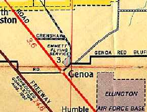
The Genoa Airport was depicted as the "Emmett Flying Service Airfield" on a 1952 Humble Oil street map of Houston.
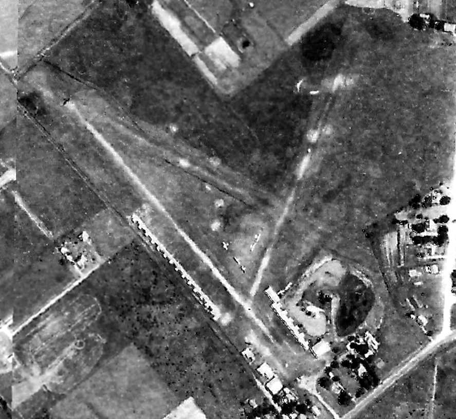
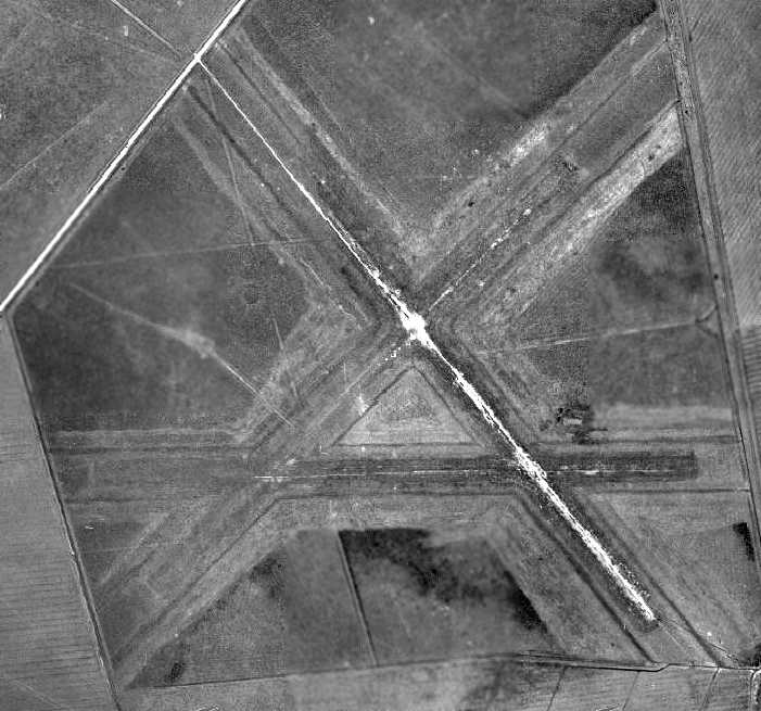
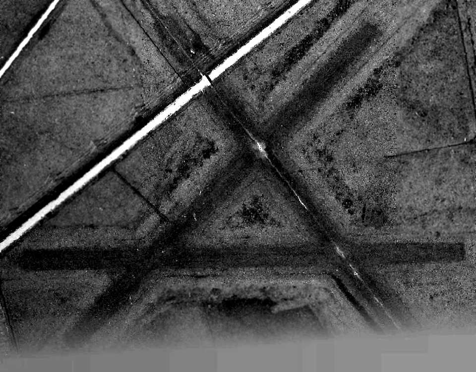
The earliest photo that has been located of the Genoa Airport was a 1953 aerial view.
It depicted the field as having 3 unpaved runways, with a large number of T-hangars on the south side of the field.
Seven single-engine aircraft were visible in the center of the field.
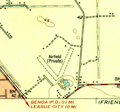
The earliest topo map depiction that has been located of the Genoa Airport was a 1955 USGS topo map.
It depicted “Airfield (Private)” as having 2 unpaved runways, with several small buildings on the south side of the field.
The earliest aeronautical chart depiction which is available of Genoa Airport was on the August 1961 San Antonio Sectional Chart.
It depicted Genoa Airport as having a 2,500' paved northwest/southeast runway.
Genoa has evidently gained a paved runway at some point between 1957-63,
as the 1963 TX Airport Directory (courtesy of Steve Cruse)
depicted the field as having an asphalt 2,200' Runway 13/31, 3 grass runways, and several small hangars.
The operator was listed as Emmett Flying Service (run by Charles Emmett).
The Aerodromes table on the 1964 San Antonio Sectional Chart (courtesy of Bill Suffa)
described Genoa Airport as having a total of 4 runways,
with the primary runway being a 2,500' asphalt strip (with a total of 3,100' of turf available).
A 1964 aerial view depicted Genoa's new paved runway.
The field appeared otherwise unchanged compared to the 1957 aerial view.
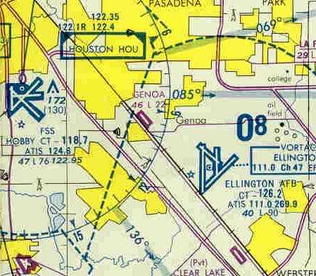
The last aeronautical chart depiction which is available of Genoa Airport was on the 1980 Houston Terminal Aeronautical Chart.
It depicted Genoa Airport as having a 2,200' paved northwest/southeast runway.
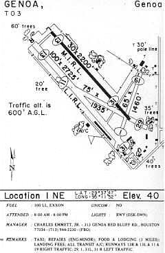
Genoa Airport's configuration was depicted essentially an unchanged manner
in the 1985 TX Airport Directory (courtesy of Steve Cruse).
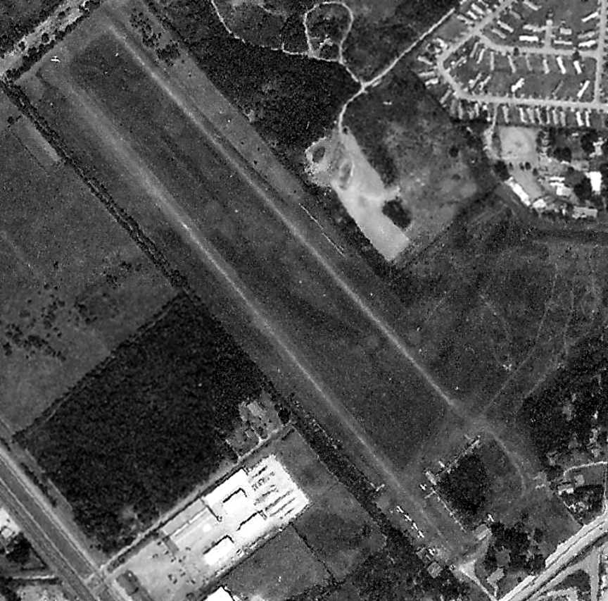
The last photo that has been located of the Genoa Airport was a 1989 aerial view.
The airport still appeared fairly healthy, with a dozen light aircraft parked on the south side of the field & another taxing onto the northwest runway end.
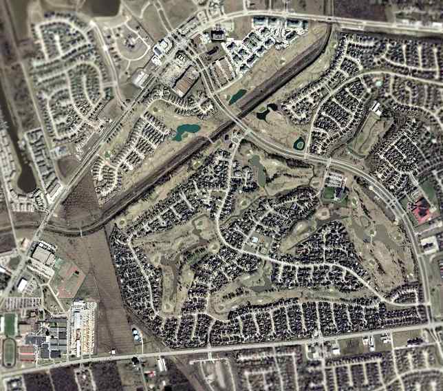
According to Douglas Warren, Genoa Airport was closed in 1990,
with the property being sold to the City of South Houston & since that time has been used as a landfill site.
The 1990 USGS topo map labeled the site as “gravel pits”.
Genoa Airport was no longer depicted on the 1992 Houston Terminal Aeronautical Chart.
In the 1995 USGS aerial photo, the area of the former runway had been excavated (presumably for gravel),
with a pit having been dug in the center of the former runways.
A 2002 USGS aerial view showed that the majority of the area of the former runways had been flooded.
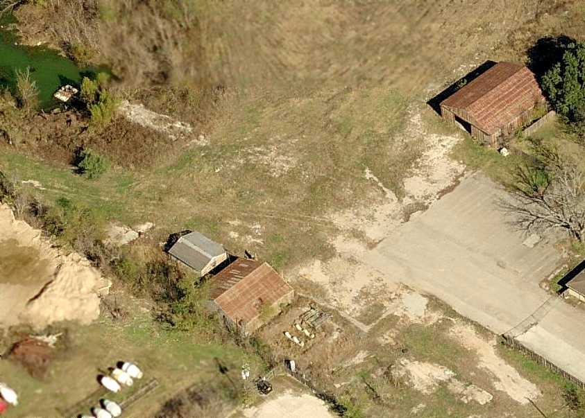
A circa 2006 aerial view looking north shows 2 former hangars (the brown buildings)
which still remain standing on the south side of the site of Genoa Airport.
The majority of the former airport had been flooded, some of which is visible at the top-left of the photo.
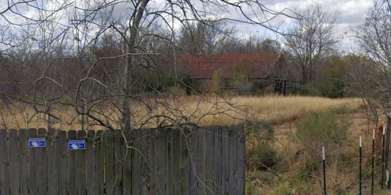
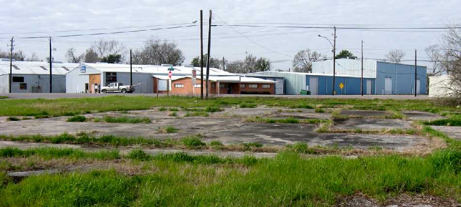
A January 2022 photo of the remains of a Genoa Airport hangar (courtesy of Douglas Warren).
A sign on the fence indicated that the property is a municipal solid waste facility.
Douglas Warren reported in 2022, “Genoa Airport... Those 2 hangars are still standing, along with what use to be the terminal/ office building, but probably for not much longer.”
Thanks to Steve Cruse for providing information about Genoa.
____________________________________________________
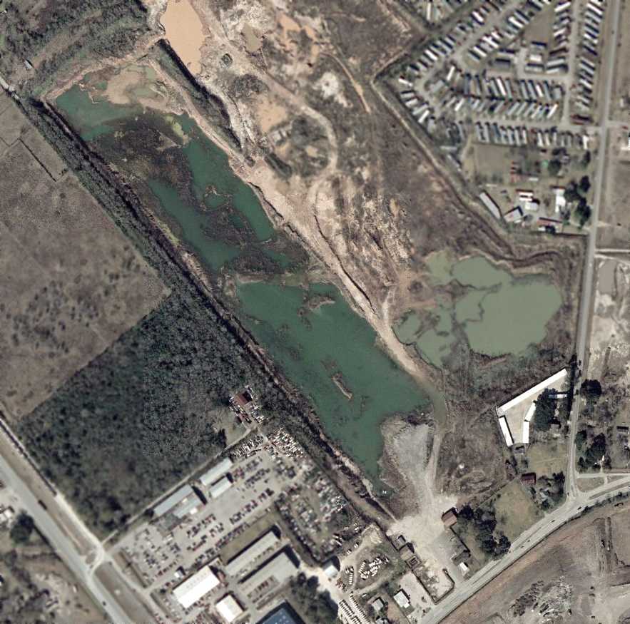
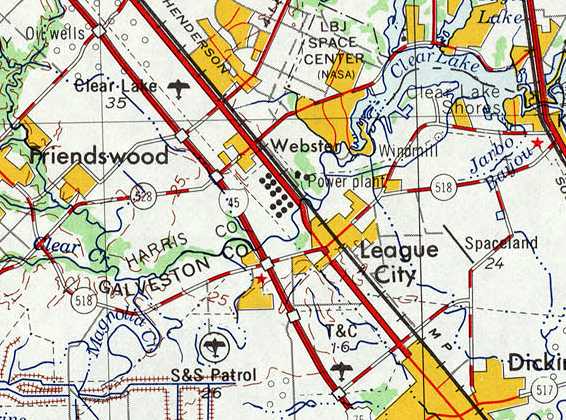
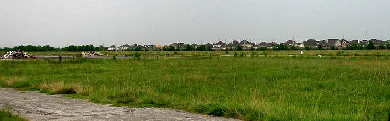
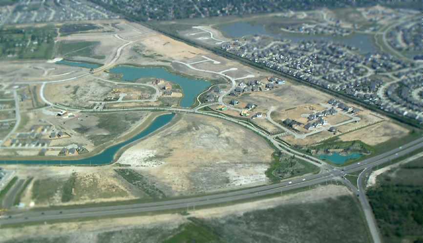
Clear Lake Metro Port (CLC), Clear Lake City, TX
29.55, -95.13 (Southeast of Houston, TX)
The earliest depiction that has been located of the Clear Lake STOLPort Airport was on the 1969 USGS topo map.
This private STOLport was operated by Metro Airlines,
which was formed in 1966 to fly commuters from the NASA Johnson Space Center to Houston Intercontinental Airport, using DeHavilland Twin Otters.
The airport was located south of the intersection of Galveston Road & El Dorado Boulevard,
only 2 miles west of the NASA Johnson Space Center.
Clear Lake Metro Port was apparently built at some point between 1966-69,
as it was not depicted on the 1964 San Antonio Sectional Chart (courtesy of Bill Suffa), nor depicted at all on a 1964 aerial photo.
The earliest depiction that has been located of the Clear Lake STOLPort Airport was on the 1969 USGS topo map.
It depicted a single northwest/southeast runway, without any label, and 3 small buildings on the southeast side.
![]()
A 1969 postmark (courtesy of Steve Cruse) commemorated the dedication of the “Houston Metro Airlines Clear Lake STOLport, serving the NASA area.”
According to Greg White, “I found time tables as early as February 1970 showing a Twin Otter on the cover & listing Clear Lake/ NASA as a stop.”

The earliest photo that has been located of the Clear Lake Metroport was a July 1970 photo of Houston Metro Airlines De Havilland Canada DHC-6-200 Twin Otter N922HM in front of the terminal.
The earliest aeronautical chart depiction of the Clear Lake Metroport which has been located was on the September 1970 Houston Sectional Chart.
It depicted Clear Lake as a private field having a 2,000' paved northwest/southeast runway.
According to Greg White, “The STOLport was in operation in 1973. I recall those odd little airplanes that Metro Airlines was using in & out of there.”
![]()
The earliest aerial photo that has been located of the Clear Lake Metroport was a 1973 aerial view.
It depicted Clear Lake Metroport as having a single paved northwest/southeast runway, with a ramp & buildings on the southeast side.
David Stall recalled, "I flew in & out of that airport as a passenger when I moved to the Clear Lake Area in 1975.
The small passenger terminal didn't appear particularly new at that time."
Clear Lake Metro Port, as depicted on the 1975 USGS topo map.
David Byrd recalled, “I worked for Metro Airlines at the Stolport in 1979-80. It was quite a busy place in those days.
A 15 minute flight from IAH for the NASA commuters working on the space shuttle.
The Stolport was privately-owned by Metro Airlines. thus a private strip.
A small terminal, a hangar for 2 Twin Otters, Budget car rental, and lots of parking.
Dispatch & maintenance offices located in the hangar. Home to a fleet of Twin Otters at that time flying routes in TX & OK.
Some out-of-service Navajos & a BE-99 were parked there also. The Shorts SD-330 began service at this time.
It was flown in to the STOLPort only a few times as it had to operate empty due to the short runway & took up almost all the ramp space.
Those airplanes overnighted & were maintained at the Spaceland Airport.”
David continued, “The STOLPort land was very valuable. Apartments & houses were creeping in every day & the air service demand changed.
It was too small for expansion & the new neighbors did not like their houses being buzzed.
Metro grew into a large commuter & was absorbed into the American Eagle system. In fact, they operated the inaugural Eagle flight in 1984.”
![]()
The 1980 Houston Terminal Area Chart (courtesy of Steve Cruse) described the "Clear Lake Metroport STOL" field as having a single 2,500' paved runway.
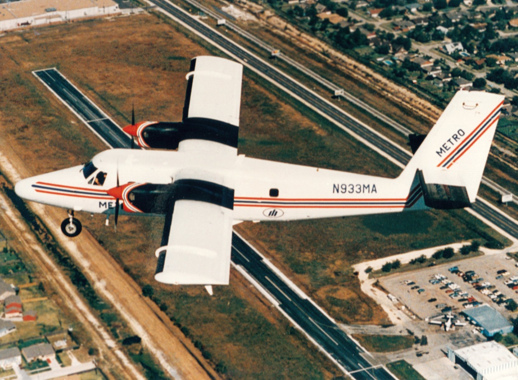
A circa 1980s aerial view (courtesy of Mike Peterson) looking north at a Metro Airlines deHavilland Twin Otter flying over the Clear Lake Metroport runway.
Another Twin Otter is visible on the ramp next to the terminal & hangar at bottom-right.
![]()
The last photo that has been located showing the Clear Lake Metroport still in operation was a 1981 aerial view.
Note the presence of a single twin-engine aircraft on the ramp.
![]()
As depicted on the 1982 USGS topo map, the Clear Lake Metroport consisted of a single 2,750' runway,
and a small passenger terminal & parking area east of the runway.
John Parr recalls, "I used to fly out of this airport, commuting to Houston Intercontinental for connections.
There were apartments RIGHT at the end of the northwest end of the runway, so the pilot HAD to take off fast.
I recall thinking how anyone could live with aircraft taking off 50' over the roof!"
David Brooks observed of Metro Port, "I used it once (1986). A Metro Airlines Twin Otter shuttled between that field & Houston Intercontinental (IAH).
The Twin Otter used only about 2,000' of runway."
According to Greg White, “By the mid-1980s they had decided that the Clear Lake operation
was becoming problematic with the growth of Hobby Airport & the encroaching city.
In early to mid-1985, they chose to sell the STOLport operation along with 6 Twin Otters to Royale Airlines of Shreveport, LA.
Prior to the sale, Metro was performing maintenance on several types of aircraft in their fleet at the hangar there.
In addition to the Otters, work was performed on the Beech 99s & the Shorts 330 (also known as 'the box the Otter came in')
but I don't believe there was ever any commercial service in those other types from Clear Lake due to the very short runway.
I joined Royale in December 1985 as a Captain on the DHC-6, not to long (months) after the sale.
I really enjoyed my time commanding the Otters in & out of Clear Lake. It was always a challenge operating out of there
and when the weather went down, we used Ellington as an alternate & I got to land there several times as well.
Once at Ellington, we would bus our passengers to & from the STOLport.
By early 1986, Royale begin to figure out that they were sold a 'bill of goods'
and by February 1986 had decided to shut down operations from Clear Lake( a lawsuit ensued).
I flew the 3rd to the last commercial flights into Clear Lake around the middle of April 1986 on the DHC-6.
I don't remember what happened after that to the airport
but I do recall the property being used as a rental car agency & other uses prior to being sold off piecemeal.”
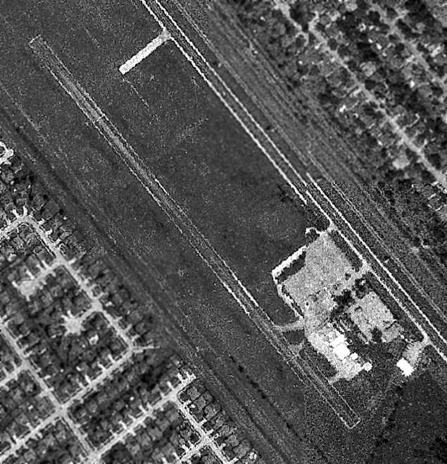
The last photo that has been located showing the Clear Lake Metroport still intact was an admittedly poor quality 1987 aerial view.
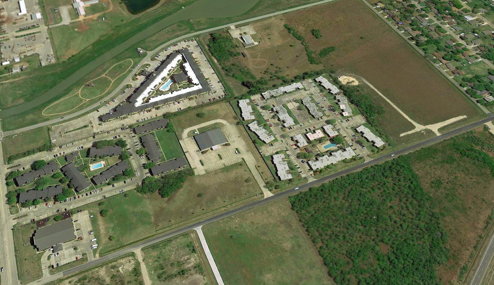
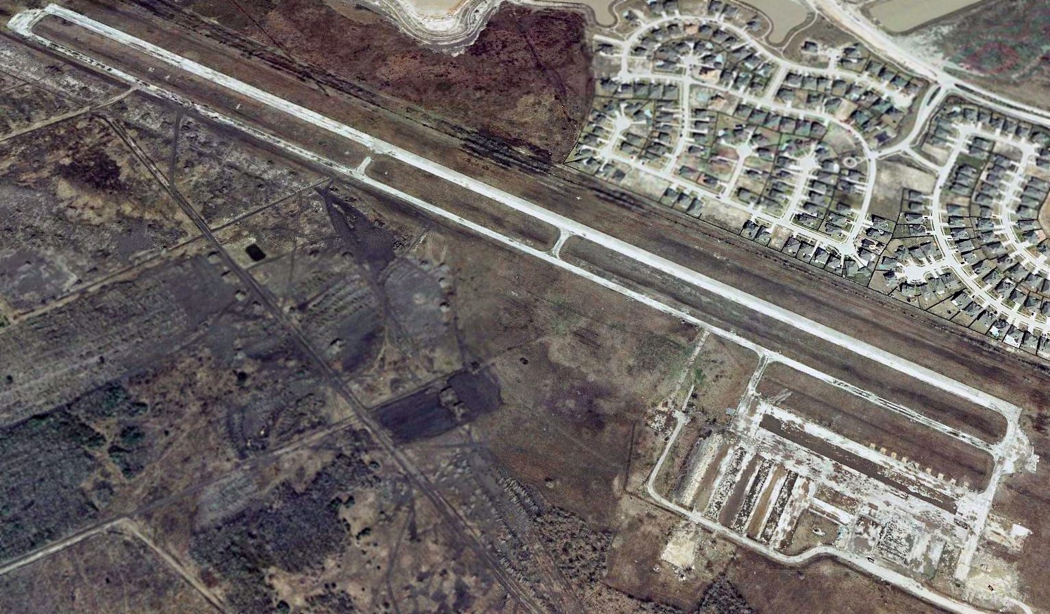
A 1989 aerial view showed that new construction had covered the northwestern & southeastern portions of the runway.
David Brooks recalled, "When I moved back here (1990), Metro had left & the field was abandoned with part of the runway gone.
Later on, a large apartment complex was built. Then a storage place, and finally, a car dealership. So, nothing remains of the airfield."
The site of Metro Port was labeled "Abandoned" on the 1990 USGS topo map,
and it was depicted as an abandoned airfield on the July 1993 Houston Sectional Chart.
The 1995 USGS aerial photo showed that a housing development had covered most of the former airport site,
with only a 900' section of runway remaining visible at the southeast end, as well as the former airport parking area.
![]()
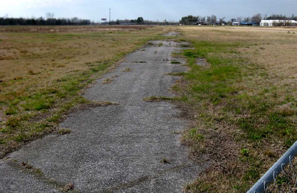
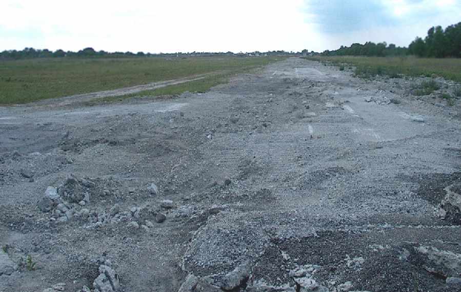
A 2003 photo by David Brooks looking northwest at the remains of the runway at Clear Lake.
"The discoloration of the grass is the only mark of where the concrete runway was."
David Byrd reported in 2008, “I have not been there in some time
but I believe the high tension towers to the north still have 2 shorter towers which made the lines lower for the approach!”
![]()
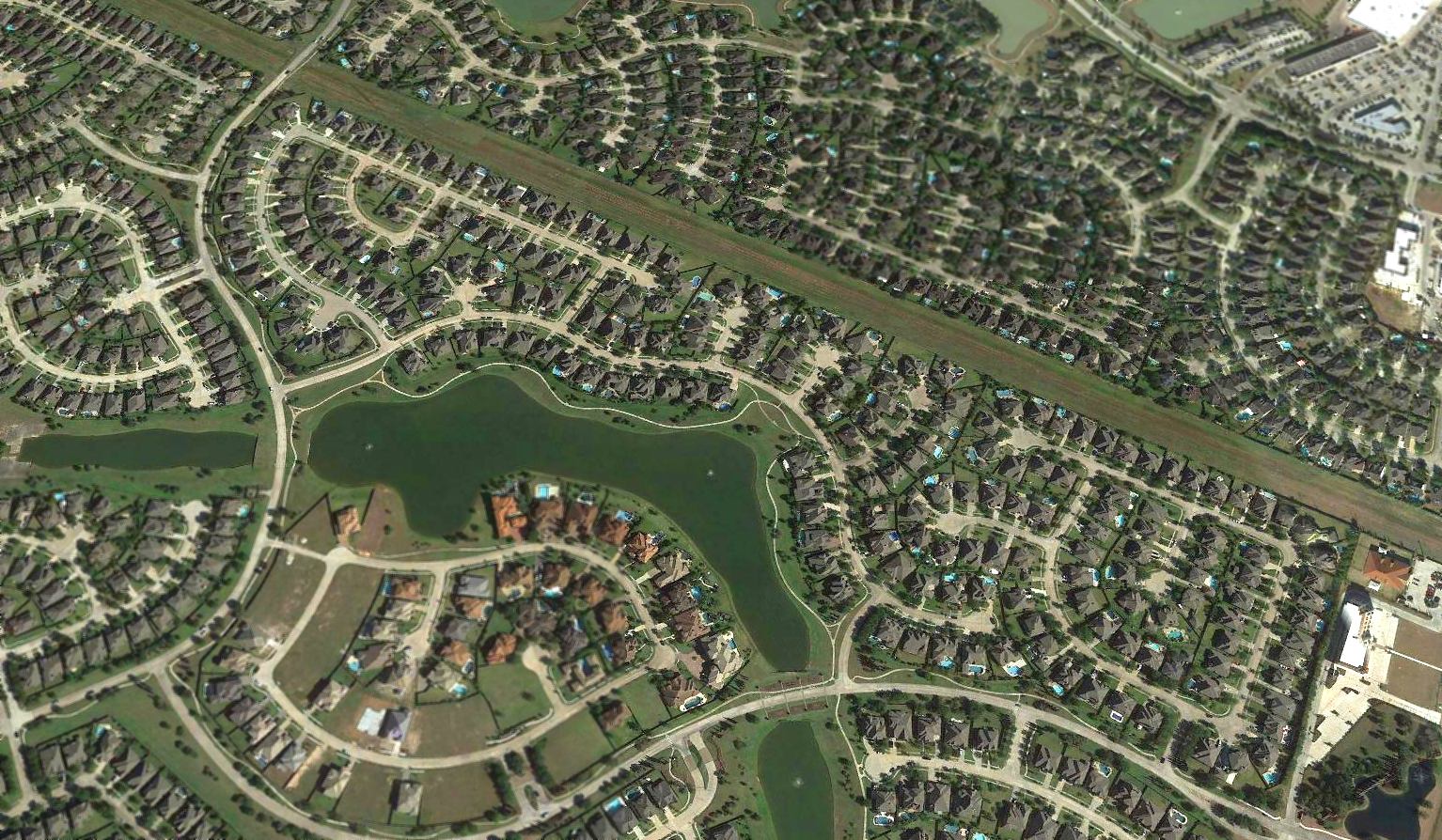
A 12/31/08 aerial photo showed that a housing development covered most of the former airport site,
but a 900' section of runway remained intact at the southeast end, as well as the former airport parking area.
Bill Broagan reported in 2023, “Clear Lake Airport... the latest [aerial] image appears to show the last vestiges of the runway being excavated for new construction.
You can see the broken concrete in the middle of the otherwise excavated area.”
Thanks to Steve Cruse for providing information about Clear Lake.
____________________________________________________
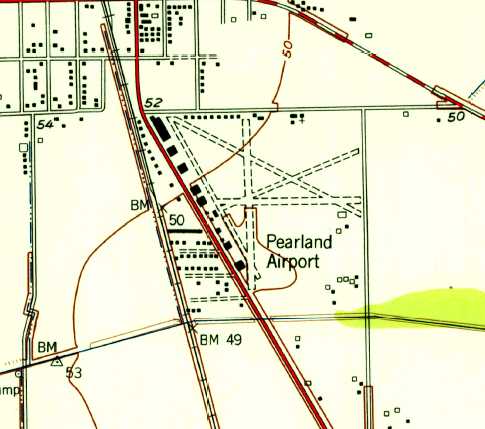
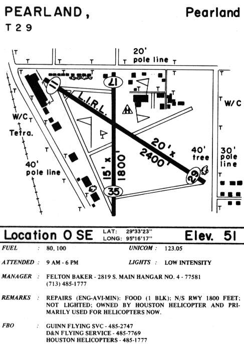
Pearland Municipal Airport (T29) / Pearland Municipal Heliport, Pearland, TX
29.56, -95.28 (South of Houston, TX)
Pearland Airport, as depicted on the August 1948 San Antonio Sectional Chart.
Pearland Airport was evidently built at some point between 1947-49,
as it was not depicted on a 1944 aerial photo,
listed among active airfields in the 1945 AAF Airfield Directory (courtesy of Scott Murdock),
or depicted on the July 1947 San Antonio Sectional Chart.
The earliest depiction which has been located of Pearland Airport was on the August 1948 San Antonio Sectional Chart.
It depicted Pearland Airport as having a 2,800' unpaved runway.
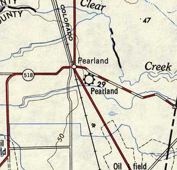
The earliest topo map depiction which has been located of Pearland Airport was on the 1949 USGS topo map.
The earliest photo which has been located of Pearland Airport was a 10/3/53 aerial view (which Av Edidin found in 2022 framed in a hamburger joint across the street).
It depicted Pearland as having 3 runways, with numerous hangars along the west side.
The 1955 USGS topo map depicted Pearland Airport as having 4 unpaved runways, with a row of hangars along the west side.
A 1957 aerial view showed Pearland Airport had gained a 4th & 5th runway at some point between 1953-57, along with additional hangars on the north side.
Pearland was described in the 1962 AOPA Airport Directory as having a 2,800' blacktop Runway 13/31 & a 2,700' shell & sand Runway 18/36.
The operators were listed as Guinn Flying Service, Jackson Flying Service, and Brockman Aero.
Gregory Meade recalled, “Pearland Airport... the owner was Raymond Kliesing & besides being a first rate character he was a hoot, a pioneer in modern aviation,
as well as the owner of the Airport Lounge, where the pilots went to water down after a hard day in the driver seat.
When I was a boy the landing approach was directly over our yard."
Jon Goldenbaum recalled, “I went to work at Guinn Flying Service, Pearland, in 1963.
The deal was: one day washing airplanes, pumping gas, cutting grass for one hour dual instruction in straight tail Cessna 150s. No cash.
Many young men came into aviation in such a fashion sponsored by Helen & Joel Guinn, a wonderful couple.
Today, (2008) I know of at least 3 airline captains & other successful professionals who got their start in the heat & humidity of Pearland.
Joel Guinn ran a successful GI bill flight school & charter operation.
He flew a D-18 Twin Beech out of the 2,600' runway day & night, we thought that was a huge runway.
Joel used to take us young lineboys along as co-pilots as he had a tough time reading the Jepp's at night.”
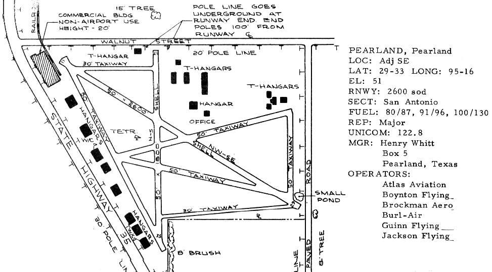
The 1963 TX Airport Directory (courtesy of Steve Cruse)
depicted Pearland as having 4 unpaved runways, with the longest being the 2,600' northwest/southeast strip.
A row of 8 hangars was located along the west edge of the field,
and a smattering of T-hangars was located on the north side.
The operators were listed as Atlas Aviation, Boynton Flying, Brockman Aero, Burl-Air, Guinn Flying, and Jackson Flying.
The manager was listed as Henry Whitt.
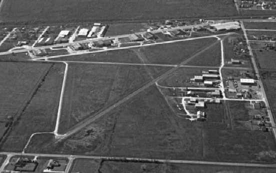
A 1964 aerial view by Jon Goldenbaum looking northwest at Pearland Airport.
Jon Goldenbaum continued, “At one time he [Joel Guinn] had a contract with the Veterans Administration
hauling patients on their last legs into Houston to the big VA hospital.
The gurney was composed of wooden coke crates strapped to the floor, a thin mattress with a sheet draped over it.
Upon arrival at Pearland, we became the ambulance drivers,
delivering the distressed patients to the VA in an old Ford Falcon station wagon ambulance.”
Jon continued, “I got my private, commercial, and CFI in the Guinn system.
Guinn Flying Service & Pearland was a wonderful place,
and a real nursery for professional pilots who came from modest means.”
The Aerodromes table on the 1964 San Antonio Sectional Chart (courtesy of Bill Suffa)
described Pearland Airport as having a total of 4 runways, with the longest runway being a 2,600' asphalt strip.
Shawn Harrison recalled, “Lori Adams ran a flight school [Lori Adams Flying Service] at the old Pearland Airport around 1968.
She moved to Hobby in October 1970.
I remember the crop dusters buzzing around; never used the pattern & zoomed underneath us to land.
Flew their planes right into the hangars.”
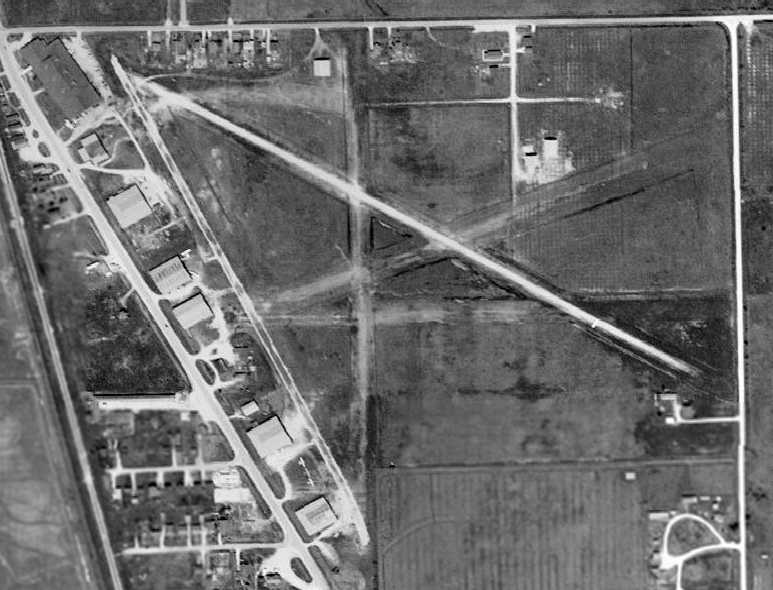
A 12/28/72 aerial view by Shawn Harrison looking west at Pearland Airport.
The last aeronautical chart depiction which has been located showing Pearland as a fixed-wing airport was on the February 1975 Houston Sectional Chart.
It depicted Pearland Airport as having 3 paved runways, with the longest being 2,600'.
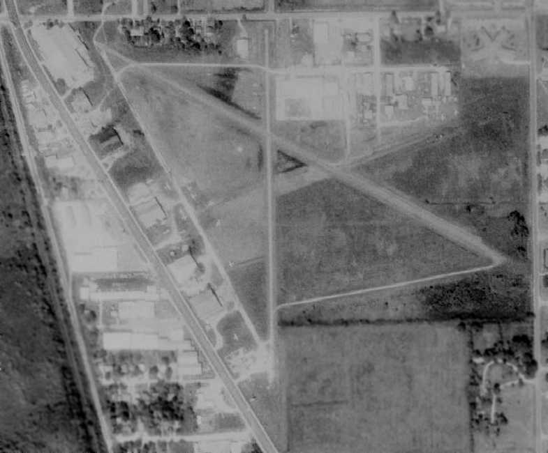
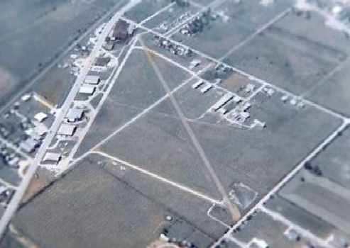
The last photo that has been located of Pearland Airport while it was still open to fixed-wing aircraft was a 1981 aerial view.
A total of 14 light aircraft were visible on the west & north sides of the field.
In the 1985 TX Airport Directory (courtesy of Steve Cruse),
Pearland Airport is depicted as having 2 paved runways (a 2,400' Runway 11/29 & an 1,800' Runway 17/35).
The operators were listed as Gunn Flying Service, D&N Flying Service, and Houston Helicopters.
A remark said, "Owned by Houston Helicopter & primarily used for helicopters now."
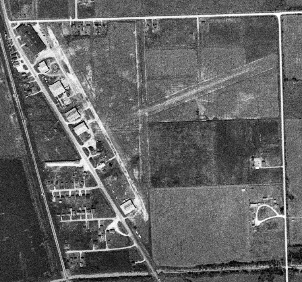
Pearland had evidently been closed as a fixed-wing airport at some point between 1985-88, as a 1988 aerial photo showed a road had been built through the center of the airport site,
and the row of 6 substantial hangars along the west side of the field had all been removed.
Outlines of the former runways were still recognizable.
Pearland had been downgraded to a heliport as depicted on the February 1989 Houston Sectional Chart.
Pearland was depicted as a "Municipal Heliport" on the 1990 USGS topo map.
Houston Helicopters continued to operate from the north side of the field.
Appropriately enough, the streets along the northern perimeter of the former airport are still named
Lockheed Street, Douglas Street, and Beechcraft Street.
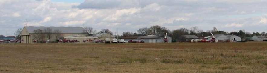
A 2003 photo by David Brooks of the helicopters currently operating from the flight line of the former airport.
David observed, “I was surprised as there is still an active heliport there.
Houston Helicopters & Bell Helicopters share a facility with what appeared outside to be about a dozen Bell choppers. The rest is quite dead.”
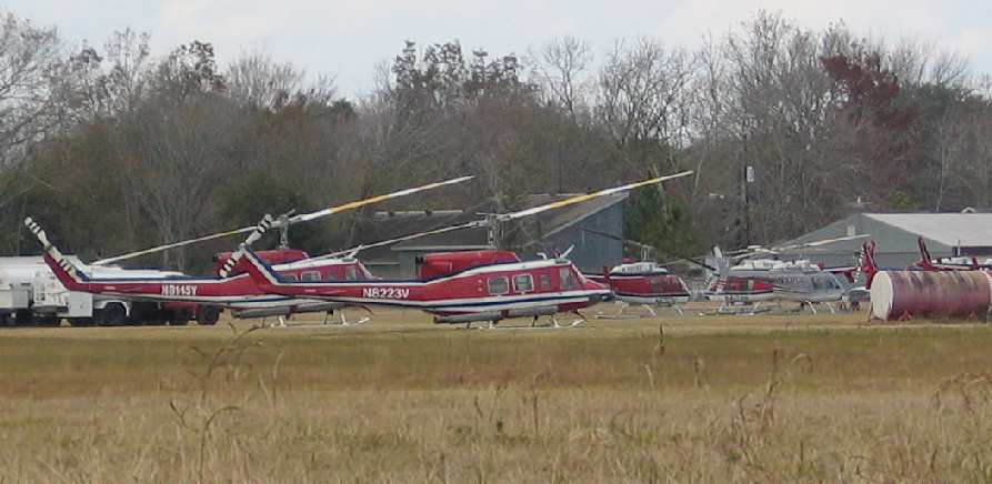
A 2003 close-up by David Brooks of the Hueys & Jet Rangers at Pearland.
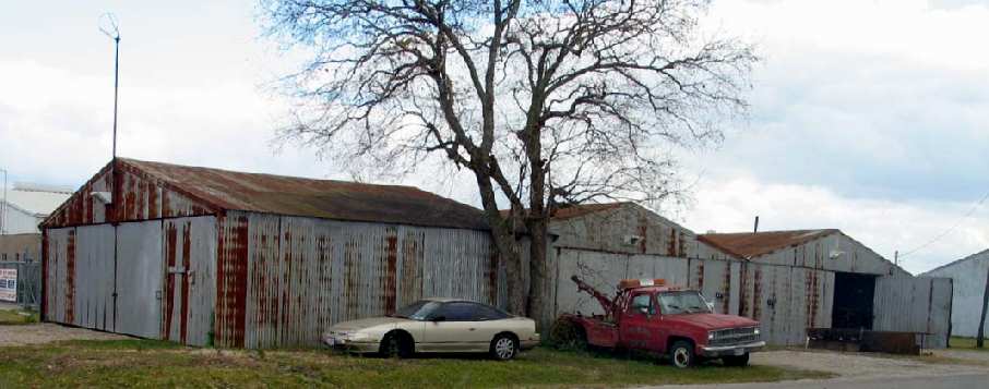
A 2003 photo by David Brooks of some of the old hangars at Pearland, now appearing to be rusting badly.
"Note the old wind sock fixture on top of first hangar."
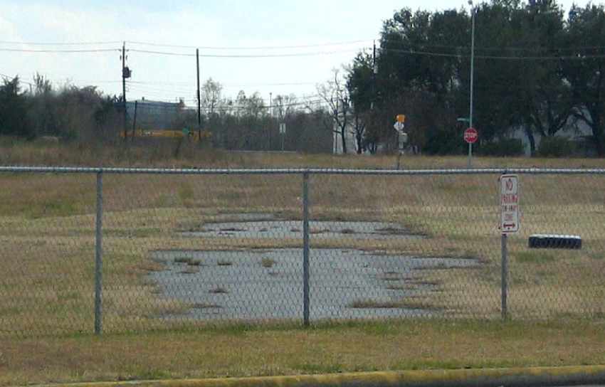
A 2003 photo by David Brooks looking south along the remains of the pavement of Pearland's Runway 17/35.
The Pearland heliport was no longer depicted on the 2004 Houston Terminal Chart (courtesy of Jonathan Westerling).
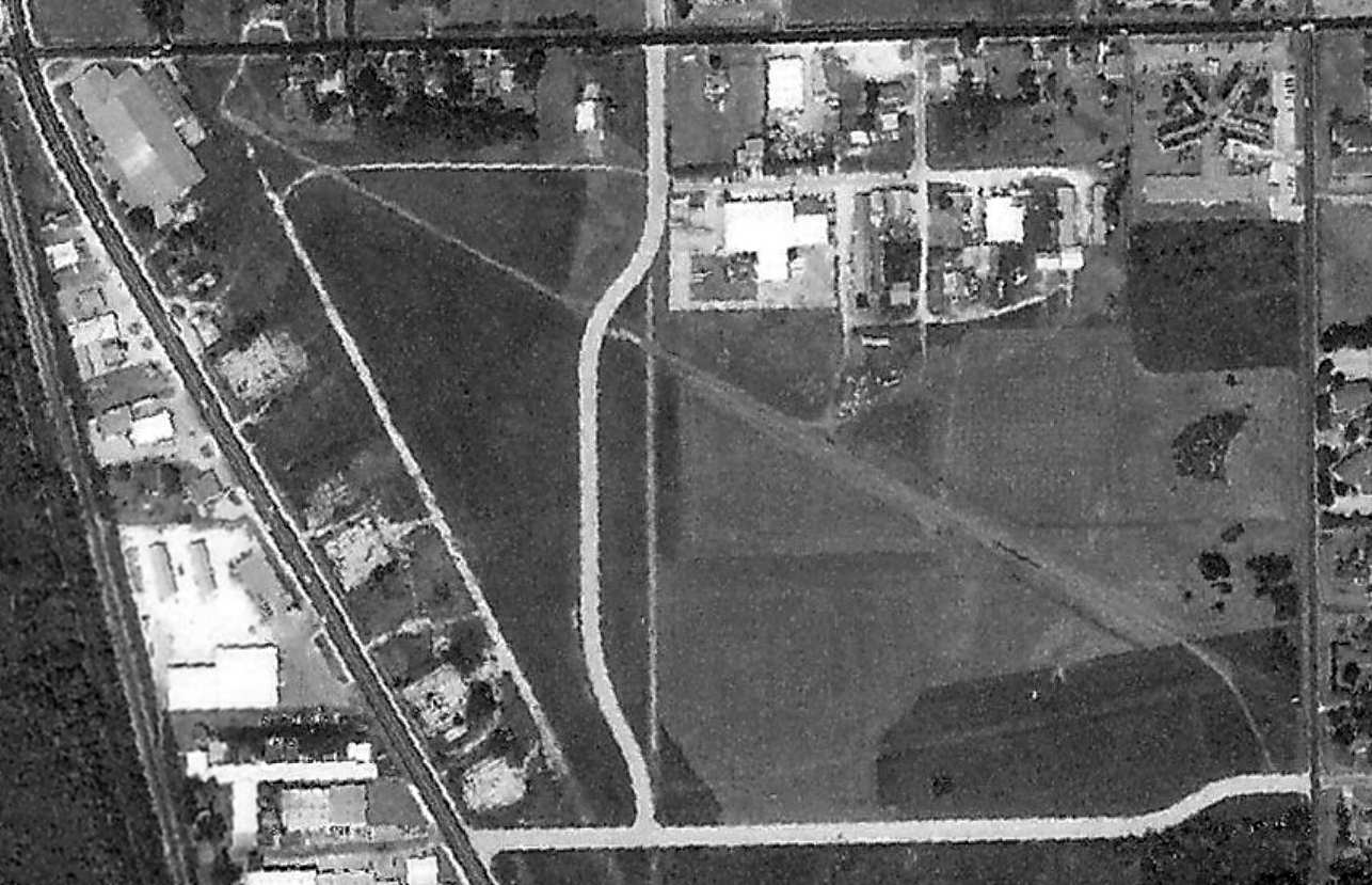
The last photo which has been located showing any aircraft at Pearland Airport was a 2006 aerial view showing 10 helicopters lined up on the ramp of the facility on the north side of the former airport.
A 2008 aerial view showed the helicopters had been removed from the facility on the north side of the former Pearland Airport.
A March 2010 photo by Tom Townsend of “the southernmost of the the buildings on the west side of the field” at Pearland.
A March 2010 photo by Tom Townsend of the remains of Pearland's Runway 17/35.
A 2015 aerial photo showed the outlines of the former Pearland Airport runways were still recognizable.

A 2017 photo (courtesy of Greg Stroud) of the sign for the new Bakers Landing housing development, on the site of Pearland Airport.
Greg Stroud observed, “The airport that was there along with any remnants has now become Bakers Landing neighborhood.
The neighborhood is still being built, but there is no sign that an airport was ever there.
However, the neighborhood offers a nod to the history of the land with the entrance to the neighborhood having air traffic control towers as part of the design & the playground also looks like an ATC tower.”
The site of Pearland Airport is located southeast of the intersection of Main Street & Walnut Street.
Thanks to Steve Cruse for information about Pearland.
____________________________________________________
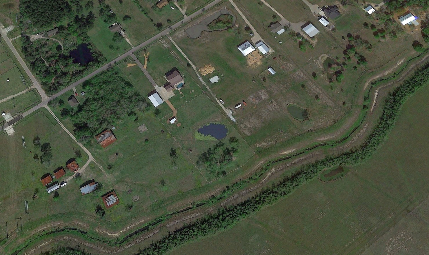
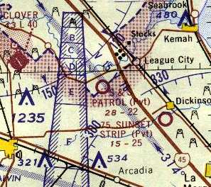
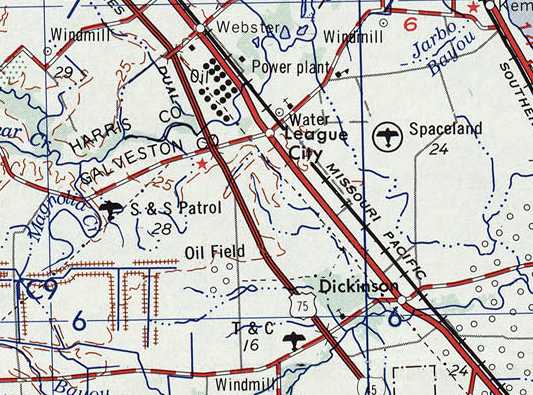
S & S Patrol Field, League City, TX
29.48, -95.13 (Southeast of Houston, TX)
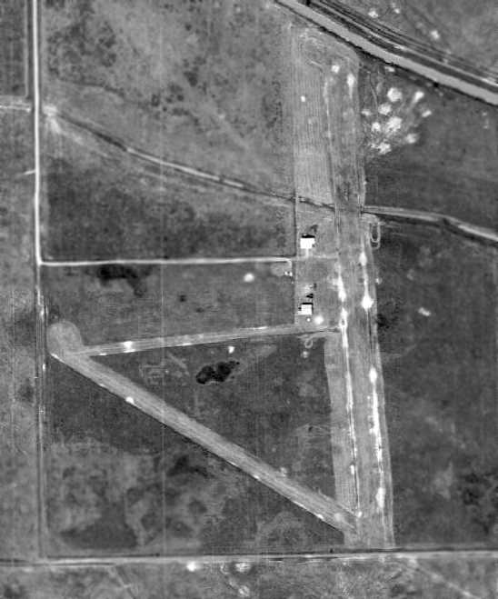
A 1964 aerial view depicted the S & S Patrol field as having 2 grass runways.
This private airfield was evidently built at some point between 1957-62,
as it was not yet depicted at all on a 1957 aerial photo.
The earliest reference to the field which has been located is in the 1962 AOPA Airport Directory,
which described S & S Patrol Field as having a single 1,367' sod Runway 16/34.
The 1963 TX Airport Directory (courtesy of Steve Cruse)
listed the manager as Robert Stevens, and the remarks said "Private; land at own risk."
The earliest photo which has been located of the S & S Patrol Field was a 1964 aerial view.
It depicted the field as having 2 grass runways, with 2 small hangars on the west side of the north/south runway.
The earliest aeronautical chart depiction which has been located of the S & S Patrol Field
was on the 1964 San Antonio Sectional Chart (courtesy of Bill Suffa).
It described S & S Patrol Field as having 2 unpaved runways, with the longest being 2,200'.
The 1967 TX Airport Directory (courtesy of Brad Stanford)
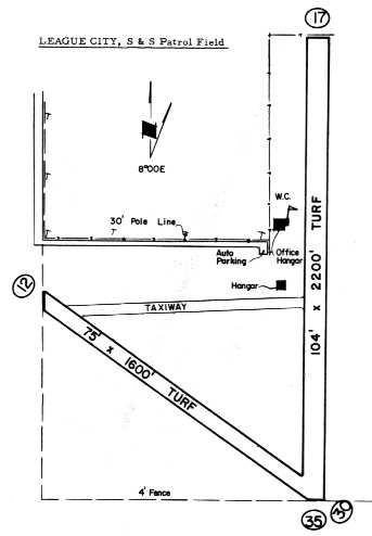
depicted S & S Patrol Field as having a 2,200' turf Runway 17/35 & a 1,600' turf Runway 12/30,
with an east/west taxiway connecting the two.
Two hangars were located along the west side of Runway 17/35. The operator was listed as S & S Pipeline Patrol.
S & S Patrol Airfield, as depicted on the 1968 USGS topo map.
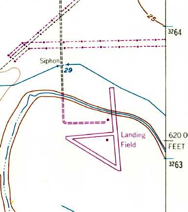
The 1969 USGS topo map depicted 3 paved runways, labeled simply as “Landing Field”, with 2 small buildings.
The 1970 TX Airport Directory (courtesy of Ray Brindle) described S & S Patrol Field in basically the same manner.
George Horn recalled, “In 1972-74 I flew for Robert Stevens, owner of S & S.
We flew mostly Cessna 150s, and a couple of Cessna 140s on pipeline patrol under contract to various pipeline companies
such as Gulf Oil, Florida Gas Transmission, Amoco, Texas Pipeline (Texaco), and others.
We operated out of S & S field as the home base,
but had pilots/planes based in TX at Fort Worth, and McCamey, as well as in Gonzales, LA, and Orlando, FL.
There was a 200' high tension line across the north end of the field,
and a takeoff on Runway 35 would make a Cessna struggle to clear it.
We usually operated to the south for that reason, as well as the prevailing winds.
In rainy weather the road to the field would flood.
I remember driving my 1964 Dodge station wagon down that road with water up to the headlights,
but the grass runways were still usable if a bit soggy.
Some interesting stories & pilots passed through that airfield.
One of the senior Captains at Southwest airlines, Ron Lane (#8 on the seniority list for a time)
once flew pipeline out of there trying to stay current so SWA would hire him.
I was the guy who hired him as my replacement.
A couple of flight planners & other NASA types also kept their planes tied down there.
S & S was one of those jobs I'd never want to do again...
but also would never take anything for the experiences it gave me.”
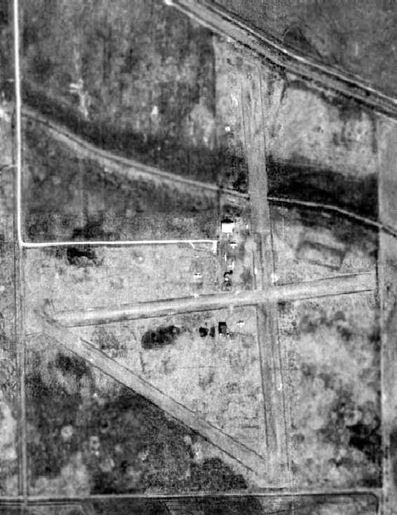
The last photo which has been located showing the S & S Patrol Field while still operational was a 1973 aerial view.
It showed that the east/west taxiway had been lengthened into a 3rd runway at some point between 1967-73.
That apparently necessitated the removal of the southern hangar as well.
But the field appeared well-used, as a total of 5 single-engine aircraft were visible on the field.
S & S Patrol Airfield, as depicted on the 1975 USGS topo map.
The last aeronautical chart depiction which has been located of S & S Patrol Field
was on the 1980 Houston Terminal Area Chart (courtesy of Steve Cruse).
S & S Patrol Field was apparently closed sometime between 1980-81,
as a 1981 aerial view showed that the northern half of the field has been covered by streets for a new housing development.
The last hangar had also been removed at some point between 1973-81.
Nearby resident David Brooks recalled, "I had always noticed on some maps
that an airfield existed on the south side of League City - not far from where I live.
It appeared on road maps, etc., but by the time I looked for it about 1991,
a major housing area existed & so I dismissed it."
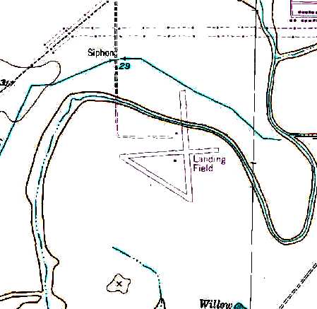
The 1995 USGS topo map depicted 3 paved runways at the site of S & S Patrol Field, labeled simply as “Landing Field”, with 2 small buildings.
A comparison of the above USGS aerial photo from 1994 & USGS topo map from 1995
shows that you can't always trust man-made maps, while on the other hand, photographs never lie.
The aerial photo is from 1994, and shows that a housing development had covered most of the area of the former airfield,
with the exception of the southern-most portion of 2 former runways, which were still visible south of the housing development.
On the other hand, the topo map is from one year later, 1995, and yet it shows the entire airfield (all 3 runways),
with no indication of the northern portion of the airfield having been covered by new streets & houses.
The last photo which has been located showing any trace of S & S Patrol Field was a 2002 aerial view looking north.
It showed that a portion of 2 runways still remained on the south side of the site.
A 2004 aerial view shows that the housing development had expanded toward the south,
covering the last remaining trace of the former airfield.
A possible clue to the residents of the housing development of what their property used to encompass
can be found on the name of the main north/south road through the housing development - Landing Boulevard.
The remains of the former S & S Patrol Airfield are located
south of the intersection of Landing Boulevard & Potomac Drive.
Patrick A. reported in 2015, “S & S Patrol Field... There are no remains of the field left.
The subdivision Brittany Lakes & Magnolia Creek are over the top of it.”
A 2017 aerial view looking north shows no trace remaining of S & S Patrol Field, with the site covered by dense housing.
Thanks to David Brooks for pointing out this field.
____________________________________________________
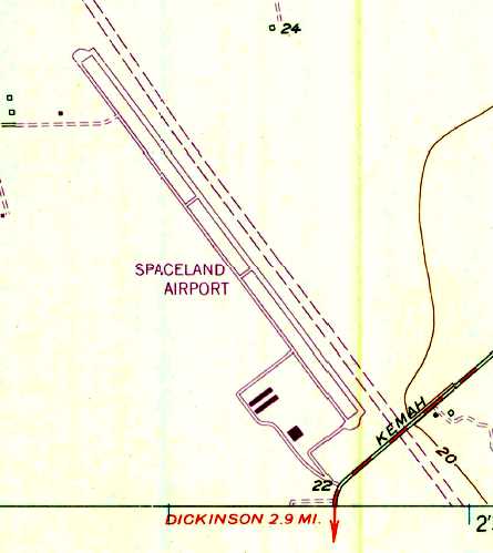
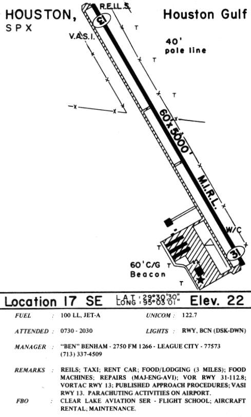
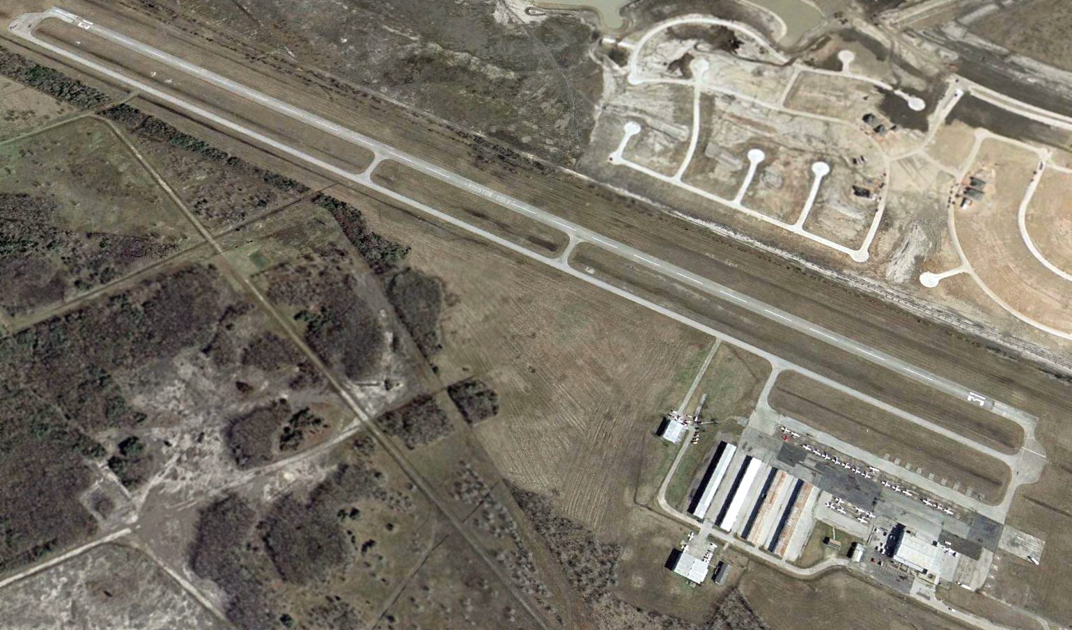
Spaceland Airport / Houston Gulf Airport (SPX), League City, TX
29.51, -95.05 (Southeast of Houston, TX)
Spaceland Airport, as depicted on the June 1966 San Antonio Sectional Chart.
No airfield was yet depicted at this location on the 1955 USGS topo map
nor on the 1964 San Antonio Sectional Chart.
David Stall reported, “I have seen a press photograph taken in 1966 labeled 'Spaceland Airpark, Inc., League City, Texas.'”
The typed notation on the back of the photograph reads, "Main hangar at the New Spaceland Airpark, Inc., located at League City which will be formally dedicated in ceremonies July 9.
Roger H. Davis is President of the $1 million privately-owned airpark."
David reported, “I understand that the hangar was part of the original construction & would have been completed shortly after the runway & other concrete surfaces.
The developers of the airport reportedly used leftover concrete from the Johnson Space Center to pour the runways.
Spaceland Airport was located about 4 miles south of the Johnson Space Center,
and was the home of many famous members of the space program, including Neil Armstrong, Deke Slayton, and Apollo 13 Flight Director Gene Kranz.
The earliest depiction which has been located of Spaceland Airport was on the June 1966 San Antonio Sectional Chart.
It depicted Spaceland as having a single paved 5,000' northwest/southeast runway.
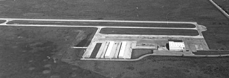
The earliest photo which has been located of Spaceland Airport was a 1968 TX General Land Office aerial view looking northeast.
It depicted the field as having a single paved northwest/southeast runway, with a paved parallel taxiway leading to a paved ramp with several hangars.
Spaceland Airport, as depicted on the 1968 USGS topo map.
The 1969 USGS topo map depicted Spaceland Airport as having a single paved northwest/southeast runway with a parallel taxiway,
and 3 buildings on the south side.
Jon Goldenbaum recalled, after getting his private, commercial, and CFI at nearby Pearland Airport,
“I went on to be an 18-year-old flight instructor for Roger Davis at Spaceland Airport.
I was one of Roger Davis' initial cadre of flight instructors when he opened Spaceland.
Roger was local flying buff who had a lot of money.
Nothing was too good in the initial years of operations: carpets, big offices, new hangars, airplanes, etc.
A far cry from the utilitarian approach of Guinn Flying Service at Pearland.
I would fly with 8 students a day in the summer, flying until I was bleary eyed & dazed.
No problem for an 18 year old.”
A 12/28/72 aerial view by Shawn Harrison looking east at Spaceland Airport showed only 2 light aircraft parked outside.
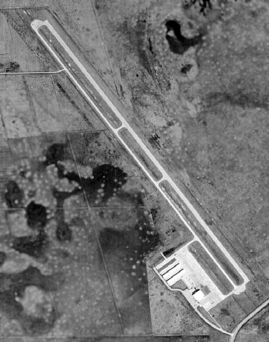
A 1973 aerial view depicted Spaceland as having a single paved northwest/southeast runway,
with a paved parallel taxiway leading to a paved ramp with 3 hangars.
Two light aircraft were visible on the ramp.
According to David Stall, "Spaceland Airpark in 1974 was home to the Bay Area Aero Club."
Spaceland Airport, as depicted on the 1975 USGS topo map.
David Stall recalled that Spaceland "was also home to the Rockwell Flying Club -
Houston Chapter (of which I was a member 1975-1976)."
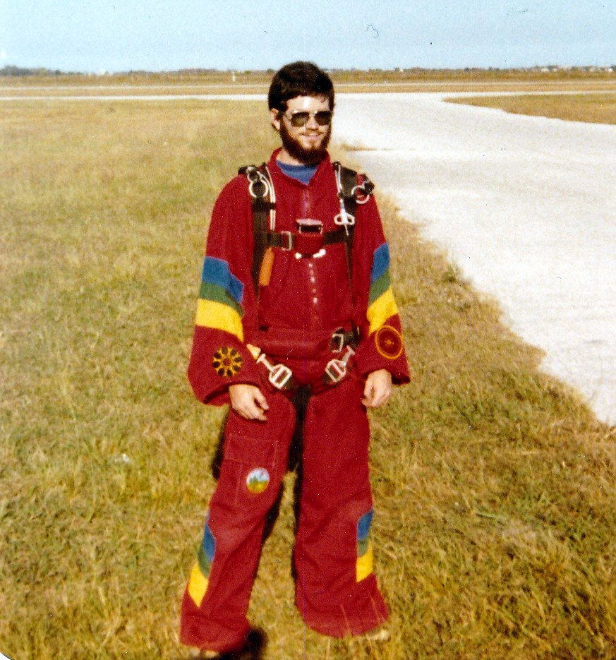
Spaceland Airport was the home of an active parachute jump operation for several years.
Jim Heffernan has documented the early days of the Spaceland Paracenter in the years 1975-76.
Jump operations were conducted by Dave Boatman, owner of the Paracenter, according to Jim.
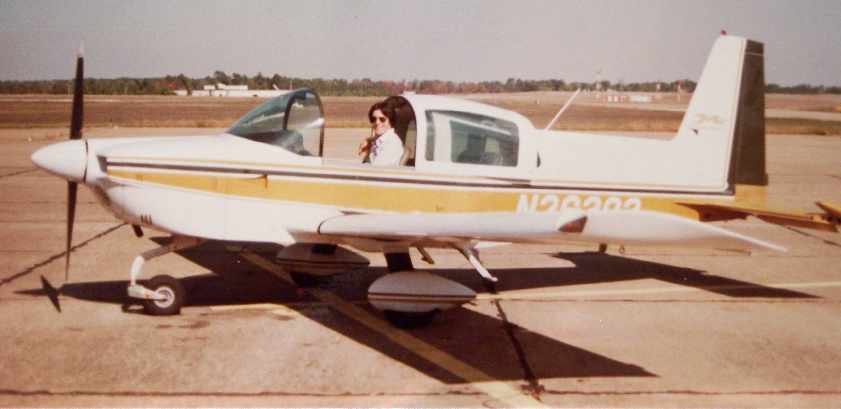
A 1979 photo of Paul Depperschmidt in a Grumman Cheetah at Spaceland / Houston Gulf Airport.
Paul Depperschmidt recalled, “Houston Gulf Airport...
I got my private pilot ticket there in the summer of 1979 flying a Grumman Cheetah.
My instructor was Curt Miles. My FAA check pilot was Dave Boatman.
There is an 'I learned about flying from that' story surrounding the check ride that is a bit embarrassing.
The short story is we crashed the plane just short of the runway. It was totaled but no one hurt.
I think they actually changed the FAA checkride procedures because of it.
I thought he had pulled the power when the engine had actually died.
Dave ended up giving me my ticket. But the FAA made me go through another checkride.”
Paul Creel recalled, “I was a Skydiver at Spaceland from 1978-83 & knew & jumped with Dave Boatman who was the owner of Metro Airlines.
Spaceland was the first dropzone in the nation to use De Havilland Twin Otters for jumping. The planes attracted jumpers from all over the world.”
A 1979 photo of skydiver Paul Creel at Spaceland Airport.
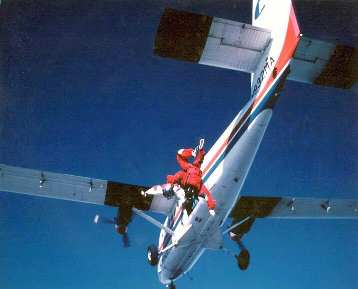
A 1980 photo of skydiver Paul Creel exiting a de Havilland Twin Otter at 15,000' over Spaceland Airport.
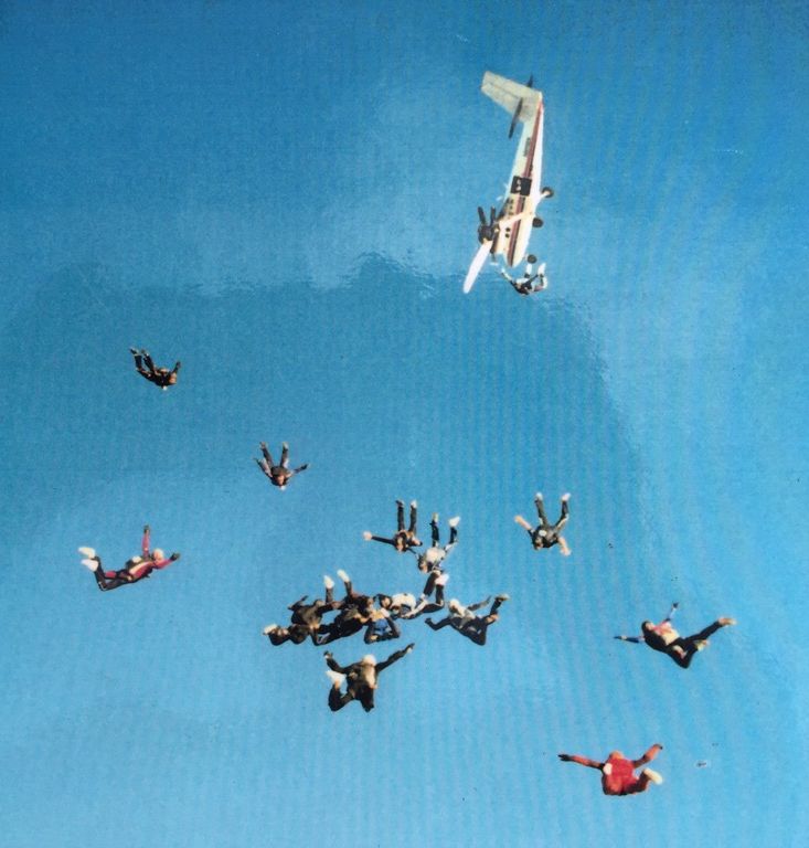
A circa 1980s air-to-air photo (courtesy of Bryan Carleton) of skydivers & a de Havilland Twin Otter over Spaceland Airport.
Bryan Carleton recalled, “My father Lindsey Carleton was the airport manager & operated Skydive Spaceland.
After flying for Dave Boatman he purchased the skydiving operation when health issues forced Dave to retire.
I spent a lot of hours mowing grass at the airport.”
At some point before 1980, the airport was renamed Houston Gulf Airport,
as that is how it was depicted on the 1980 Houston Terminal Area Chart (courtesy of Steve Cruse).
It was described as having a single 5,000' paved runway.
A 1981 aerial view showed that a 3rd row of T-hangars had been added since 1973.
Jon Anderson recalled, “Spaceland Air Park: The Attwater's Prairie Chickens used to do their mating dance at the airport there.
This bird, related to the now-extinct Heath Hen, is endemic to the Gulf coastal grasslands & listed under the Endangered Species Act.
There are few bird-watchers left who ever saw these 'chickens' at the Spaceland site.”
In the 1985 TX Airport Directory (courtesy of Steve Cruse),
Houston Gulf was depicted as having a single 5,000' paved Runway 13/31,
a parallel paved taxiway, and a paved ramp at the southwest end with 5 hangars (one of which had been added since 1981).
The operator was listed as Clear Lake Aviation Service.
Robert Winkler recalled, “I learned to fly at this airport in 1985,
flew in the Bay Area Aero Club, and for years we hangared our Bonanza there.
My house is in a subdivision less than one mile east of the airport, which was one of the reasons I bought there.”
Houston Gulf Airport had a curious tie-in to recent world events,
as it was purchased in the mid 1980s by Salem Bin Laden - Osama’s older half-brother.
Bin Laden’s estate has sought to sell the property since his death in a 1988 ultralight crash in San Antonio.
They finally succeeded, although the purchaser was Johnson Development,
which planed on demolishing the airfield & building upscale houses on the property.
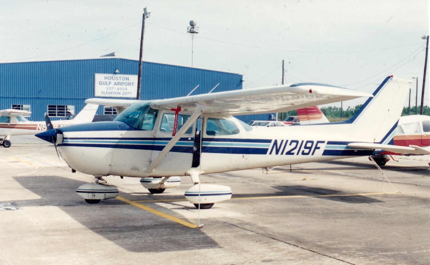
A 1986 photo by Ted Dyson his Cessna 172, N1219F, “parked at Houston Gulf Airport (also known as SpaceLand).
You can see the freshly-painted main hanger in the background.”
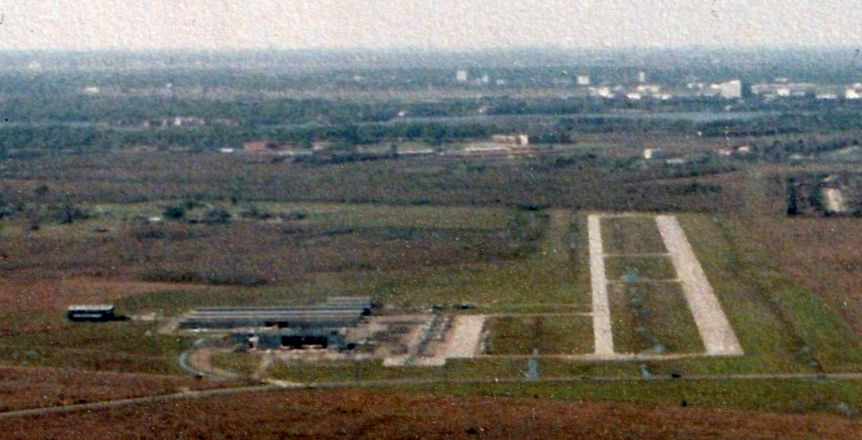
A 3/19/88 aerial view by Ted Dyson looking northwest at Houston Gulf Airport on approach to Runway 31.
George Horn recalled, “I last landed in a Baron at Houston Gulf in the 1990s carrying a politician to a meeting.
A Stearman nearly landed directly on top of us. He was not using his radios. I went-around & when I finally got to the ramp that pilot had rushed off in his car.”
Thanks Paul for a great site. Keep up the good work!
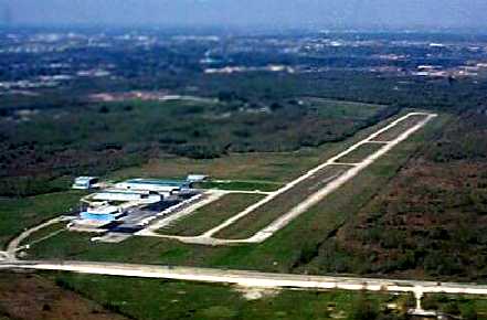
A 3/4/00 aerial view looking west at Houston Gulf Airport by Kerry Newman (courtesy of Eric Newman).
Eric recalled, “I had my first flight in N6667F in 2000 when I was 9 years old.”

A 9/30/00 photo of a Piper Tripacer at Houston Gulf Airport.
A 2001 USGS aerial view looking northeast, photo, taken apparently only a few months before Houston Gulf Airport closed.
Note the total of 28 light aircraft on the field.
However, the cause of the airport's demise has also appeared adjacent to the east side - new housing construction.
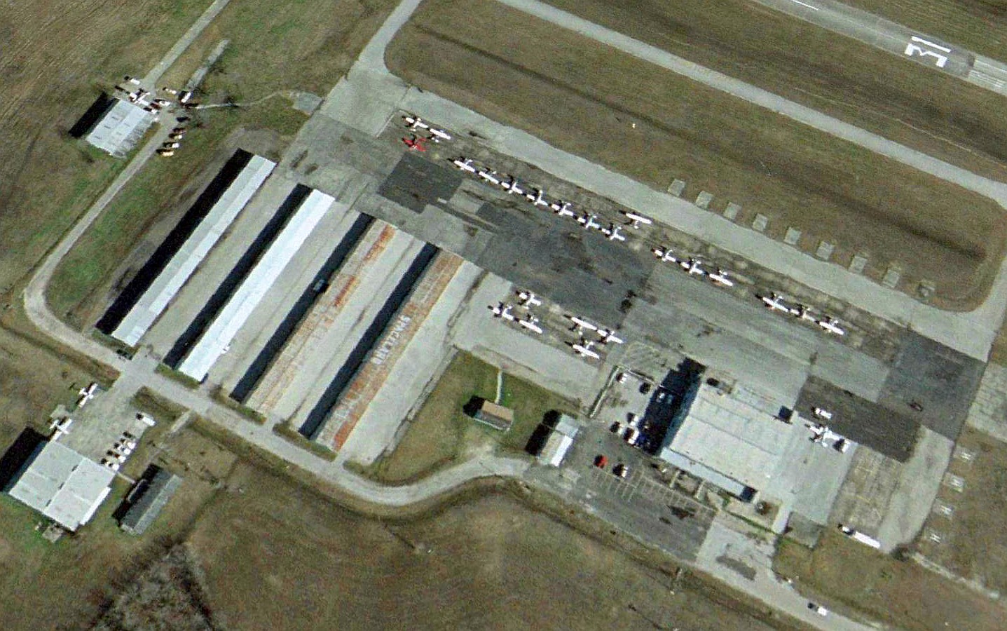
A closeup from the 2001 USGS aerial view looking northeast at the Houston Gulf ramp. Note the “Spaceland” lettering, visible on the roof of one of the hangars.
The last aeronautical chart depiction which has been located of Houston Gulf Airport was on the March 2001 Houston Sectional Chart.
It depicted Houston Gulf as having a 5,000' paved northwest/southeast runway.
Houston Gulf Airport closed in 4/02.
At the time of its closure, Houston Gulf Airport consisted of a single 5,000' asphalt runway, 13/31, a parallel taxiway, a ramp & several hangars.
It was home to 80 based aircraft, including 2 jets & 2 helicopters.
The Airport Facility Directory listed it as conducting an average of 66 takeoffs or landings per day.
Houston Gulf Airport was home to the Bay Area Aero Club (with 230 members), which moved to Clover Field, and Houston Gulf Avionics.
According to airport operator Helen Paige, neither the city nor county was interested in purchasing the 365-acre property,
leaving Galveston’s Scholes Field as the county’s only public airport.
In the words of the airport operator, "The most devastating part to us as lovers of aviation is that we’re losing an airport.
We’re all devastated because it’s going away. Once you put houses on a piece of land it doesn’t go back the other way."
Cindy Mahler runs a group named Houston Gulf Airport Coalition, which is "currently fighting to save our beloved airport."
According to Cindy, "No houses currently occupy the airport land,
but the developers who are trying to buy the airport do have plans to put them there if they win."
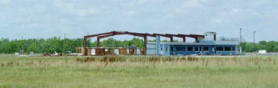
A 2002 photo by Doug Warren, showing a hangar at Houston Gulf which was being dismantled within the same year that the airport was closed.
David Brooks reported in 2003, "The last time I was there it was still open & full of aircraft (including a number of jets).
However, with the rate of house building in this area - I am not surprised that it would be taken over."
Houston Gulf was still depicted on the 2003 Sectional Chart, but labeled "Closed".
A sad 2003 photo by David Brooks, showing piles of rubble from the demolished hangars at the former Houston Gulf Airport.
A 2003 photo by David Brooks, showing a car driving down the former runway of the Houston Gulf Airport.
David Brooks reported in 2003, "All structures are gone.
The ramp, taxi way, and runway are still present but a lot of grass & weeds have grown up around them & in the cracks.
The property is privately owned & they would not allow me to access the property to take pictures.
So all I could do was to take pictures from the public roads.
No housing development yet, but you can see in the distance, they are getting close.
Probably in the next year or so, the old airfield will be turned into an upscaled housing development."
A 2003 aerial view by Jason McClure, looking southeast at the abandoned Houston Gulf Airport.
A sad 2003 photo by Jason McClure, of the wreckage that remains of former hangars at Houston Gulf Airport.
Jason McClure reported in 2003, "My dad flew out of Houston Gulf from about 1999 through its closing.
I think the runway is still all there but the taxiway & parking lot are being torn up."
A 2004 USGS aerial view looking northeast at the site of Houston Gulf Airport showed all of the hangars had been scraped away, although all of the paved surfaces remained.
David Brooks reported in 2004, "I drove past the closed Houston Gulf / Spaceland Airport.
It is now virtually gone. Whoever owns the land now has leveled everything for about 2 miles alongside the road.
The main runway has been broken up & about 80% removed.
The taxiway is being broken up. So progress (urban sprawl) has taken another wonderful airfield to oblivion."
A 6/25/05 aerial view showed that the southeastern third of the runway had been covered by housing construction.
David Brooks reported in 2005, “All remains are gone now.
Roads for a large housing subdivision have been put in along with utilities, street lights,
and a large berm at the entrance (I assume for some decorative thing to be built in the front).
A sign says houses starting at $500,000 & up. Awful to see all of this urban sprawl.”
A 1/15/06 aerial view showed all remaining traces of the former airport having been covered by construction.
A March 2006 aerial view by Robert Winkler, looking north at the site of the former Houston Gulf / Spaceland Airport,
now the location of the Tuscan Lakes housing development.
Robert observed, “To lose this airport so suddenly was a real loss to the local aviation community. It was a great airport.
I drive by here just about every day, and every day it breaks my heart to see more houses.”
A 2006 photo by Paul Depperschmidt of the former runway at Houston Gulf.
Paul reported, “Last year [2006] I went back to the area & wanted to drive by my old airfield.
I had a GPS & was sure I was in the right spot. But no Houston Gulf. I finally realized it had been absorbed by the surrounding subdivisions.
I took a couple of pictures. One is the runway as it was being torn up.
The other is of the only solid piece of anything that looked like the concrete base of the airport light.
I picked up a chunk of the runway & saved it. I plan to make it in to some type of wall hanging.”
A 2017 aerial view looking northeast showed no trace remaining of Houston Gulf Airport.
Thanks to Paul Reinman for pointing out this field, and to Steve Cruse for additional information.
See also:
____________________________________________________
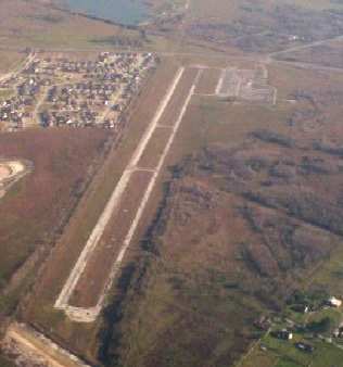
Hitchcock Naval Air Station, Hitchcock, TX
29.33, -95.05 (West of Galveston, TX)
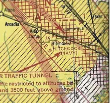
"Hitchcock (Navy)", as depicted on the June 1943 San Antonio Sectional Chart (courtesy of Richard Doehring).
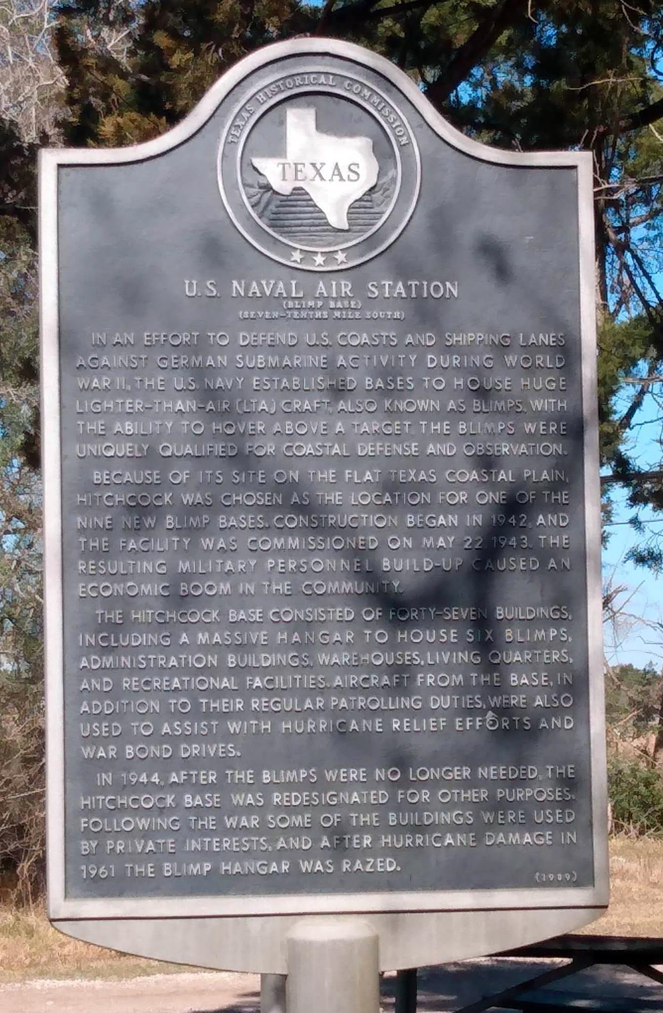
NAS Hitchcock was commissioned in 1943 as a Navy Anti-Submarine Warfare blimp base.
The earliest depiction which has been located of the Hitchcock airfield
was on the June 1943 San Antonio Sectional Chart (courtesy of Richard Doehring).
It depicted "Hitchcock (Navy)" as an airfield, but curiously did not depict a mooring mast symbol.
Situated close to open water yet remote from urbanized development, Hitchcock proved an ideal site for ASW blimp patrols.
It had a very similar configuration as other WW2 Navy blimp bases (Tustin, CA, Weeksville, NC, Tillamook, OR, etc.).
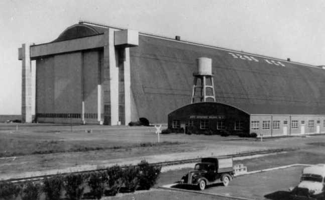
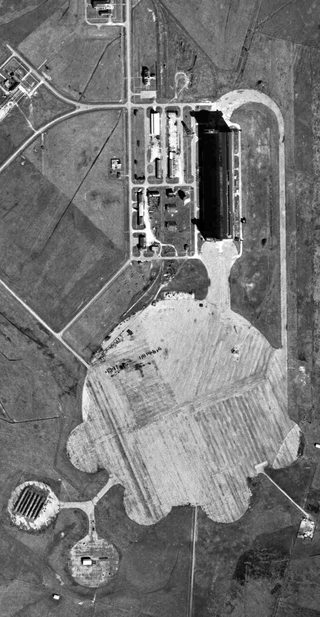
The centerpiece of the base was its gigantic blimp hangar.
Hitchcock was originally intended to have 2 of the huge blimp hangars, which were typical of WW2 Navy blimp bases, but only one was built.
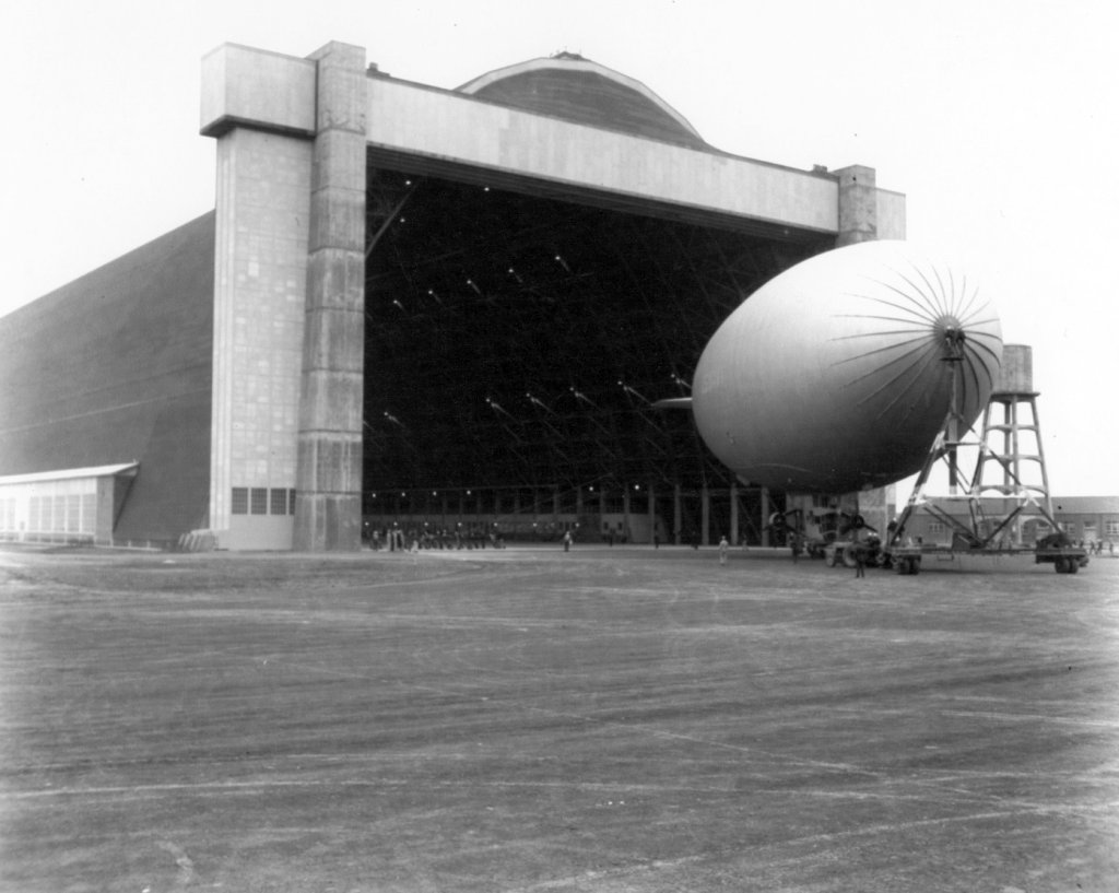
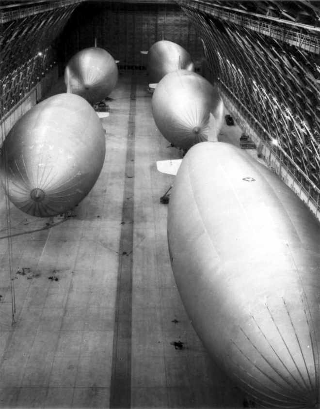
An 11/30/43 photo of a Navy blimp being maneuvered with its mobile mooring mast in front of the massive Hitchcock hangar.
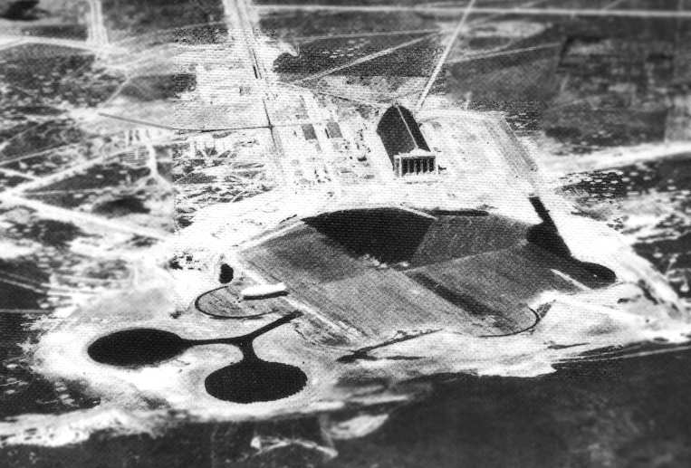
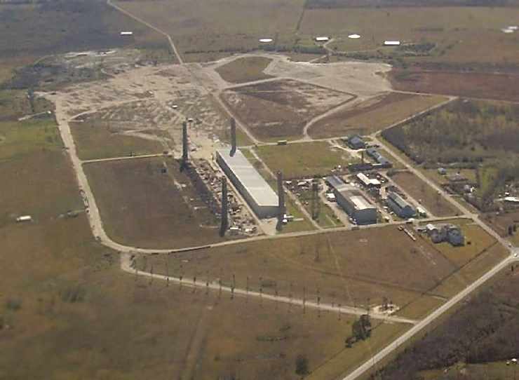
A WW2-era aerial view looking north at Hitchcock (National Archives photo).
Note the blimp moored to the left of the primary mooring pad.
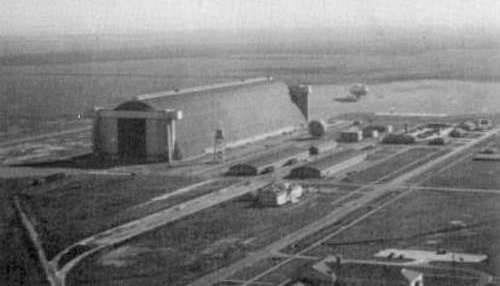
A 1944 aerial view looking southeast at Hitchcock (National Archives photo).
A K-class blimp is visible on the mooring circle to the right of the hangar.
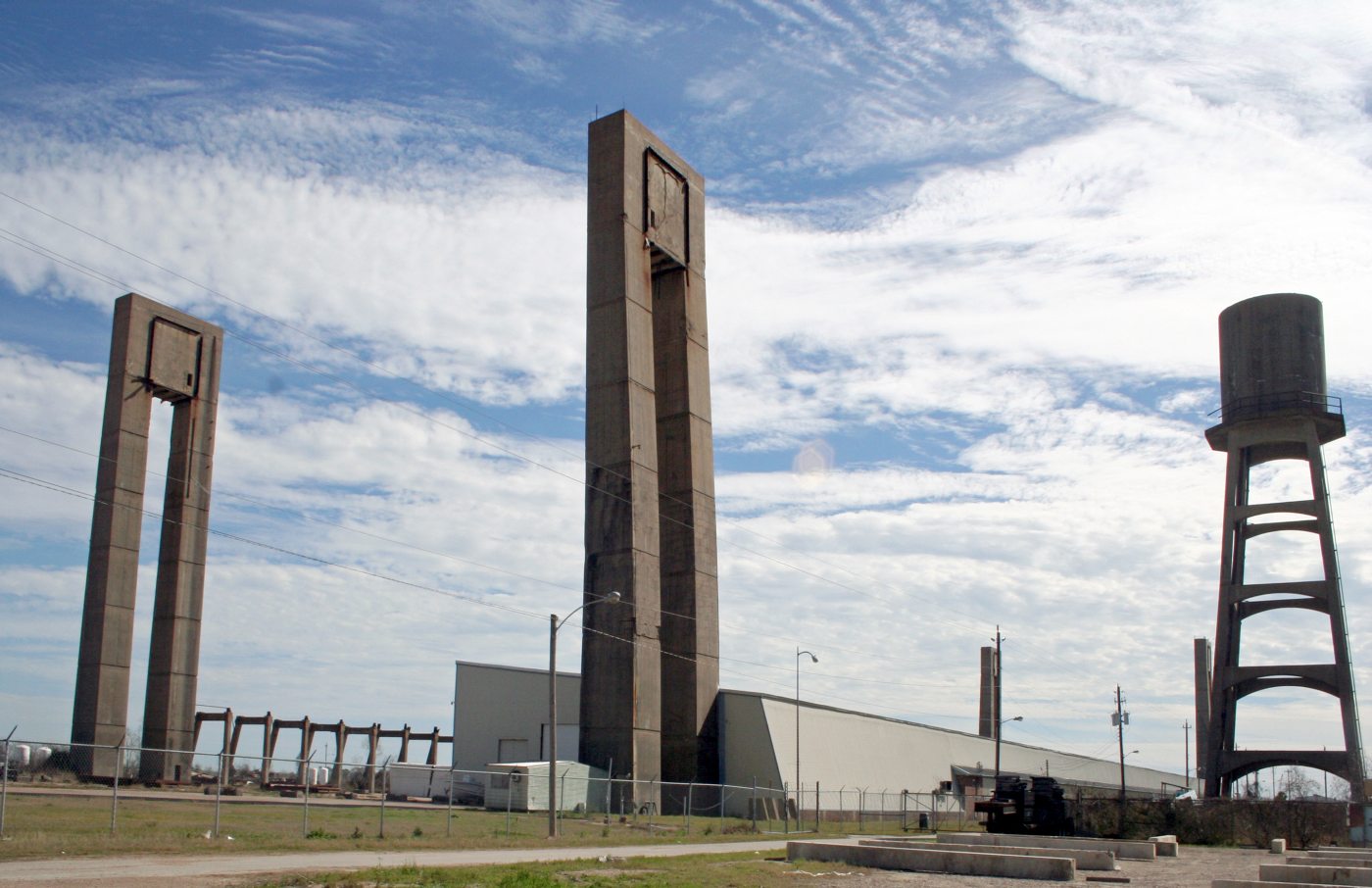
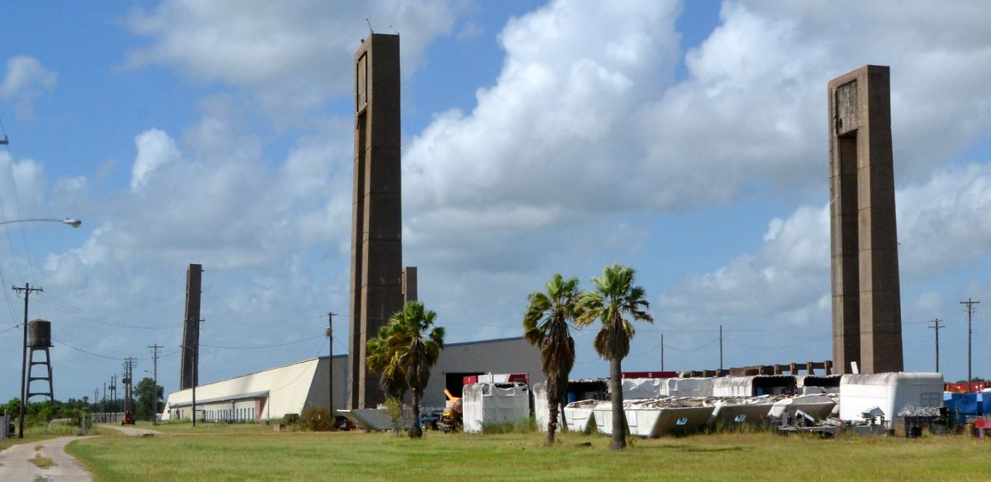
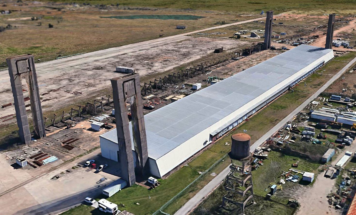
The massive hangar was 1,000' long, 300' wide & more than 200' tall.
With 300,000 square feet of open floor space, the hangar housed up to 6 K-type blimps.
A rail spur, extending the entire length of the hangar’s interior,
linked the facility to the town’s railroad about 2 miles away.
The entire structure was built of wood anchored on each end by 2 concrete double pillars.
Hitchcock's hangar was the last of the wooden blimp hangars to be built during WW2.
A WW2-era photo of Hitchcock's massive hangar,
with what appears to be the field's radio frequency of “329.5 KCS” painted on the roof.
Outside its massive hangar doors lay a 2,000' diameter circular concrete landing mat,
80 acres in area, used for mooring blimps.
It also had 6 smaller circular blimp mooring pads arrayed along the southern edge of the primary pad.
Other base facilities included workshops, vehicle garages, barracks, administration buildings,
a 40,000-square-foot brick warehouse,
and a recreation center equipped with auditorium, gymnasium and swimming pool.
Commander Charles Roland was installed as base commander & 133 personnel were assigned to the station.
The first airship arrived that year, and Blimp Squadron ZP-23 was established.
Later, detachments arrived from ZPs 21, 22 & 24, all part of Fleet Airship Wing 2.
During the ensuing year, numerous patrols were made over Galveston Bay & the Gulf of Mexico.
At its height, Hitchcock encompassed 3,500 acres & housed nearly 150 personnel,
who operated a total of 12 blimps on antisubmarine patrols,
Despite the blimp crews’ aerial vigilance, no submarine sightings were reported in the Galveston area,
and the operational life span of NAS Hitchcock was shortened.
After only 17 months of service, the base was redesignated a naval air facility in 1944, to operate heavier-than-air aircraft.
By that time, the U-boat threat in the Gulf of Mexico had diminished, and blimp patrols were no longer necessary.
Conventional aircraft were operated from a north/south concrete runway, 3,300' long,
visible on the east side of the base in above photograph.
After only a few months of operating conventional aircraft, the base was decommissioned again in 1944.
Hitchcock was disestablished by the Navy in 1947, and the base was sold as surplus.
Much of the surrounding property was bought for rice storage, cattle grazing & residential use.
The hangar was sold in 1949 to H.L. Harvey, who used it to store large quantities of rice.
It later housed oil drilling equipment, and then was used to rebuild tanks & half-tracks.
The 1949 USGS topo map depicted Hitchcock as a military airfield.
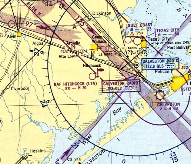
The last aeronautical chart depiction which has been located of the Hitchcock base was on the March 1950 San Antonio Sectional Chart.
It depicted "NAF Hitchcock (LTA)" as an active military airfield,
with a mooring mast symbol, and described as having a 2,000' hard-surface runway.
The airfield at Hitchcock was no longer depicted on the August 1950 San Antonio Sectional Chart.
In 1950 the Hitchcock property was purchased by oilman John Mecom.
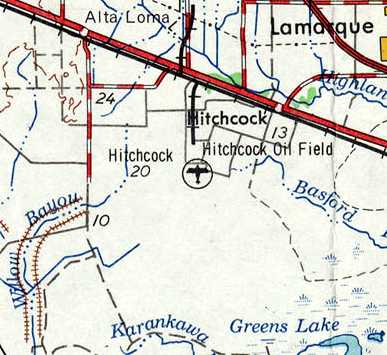
The last depiction which has been located showing an airfield at Hitchcock was on the 1956 USGS topo map.
The blimp hangar was used for manufacturing & storage until it was heavily damaged by Hurricane Carla on 9/11/61.
The last photo to be located showing Hitchcock's massive blimp hangar before its demolition was an 11/23/61 USGS aerial view.
As a result of its hurricane damage, Hitchcock's massive blimp hangar was torn down in 1962.
The hangar’s 4 massive support pillars were too strong to be razed economically & were allowed to remain.
The 1968 USGS topo map no longer depicted any airfield at Hitchcock.
A 1969 aerial view showed Hitchcock after the blimp hangar's removal.
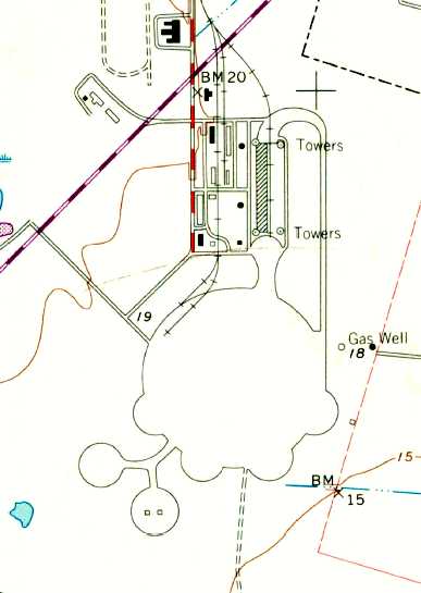
The 1969 USGS topo map depicted Hitchcock's abandoned blimp mooring circle & pads, and the towers of the former blimp hangar.
Depicted in between the former hangar columns was a 100,000 square foot warehouse which was built at some point between 1962-69.
A historical plaque was erected in 1989 to commemorate NAS Hitchcock.
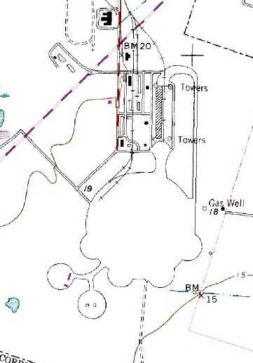
The 1995 USGS topo map still depicted the Hitchcock blimp mooring circle & 2 smaller mooring pads to the southwest.
The 1/15/95 USGS aerial photo appeared to depict the former blimp field in a completely abandoned fashion, with no significant redevelopment.
The hangar’s remains & a light industrial zone stand on the highway’s south side.
Over the years, most of the base’s original buildings have vanished,
some were demolished for redevelopment, others crumbled from neglect.
The 2-story administration building & former base water tower still stand, though.
James Rogerson observed in 2003, "This site has been the home of many race car testing sessions.
It was once owned by John Mecom. He tested his many race cars using the concrete pad.
It was purchased about 4 years ago in conjunction with the Corvette Club of Houston to build a motorsports park."
Walt Fricke provided some further details about John Mecom's use of the Hitchcock base.
Fricke's Beech Staggerwing "was owned by John Mecom (Oil) & operated out of Hitchcock for years.
It has the Mecom Oil paint scheme."
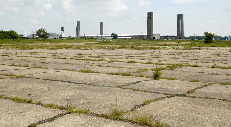
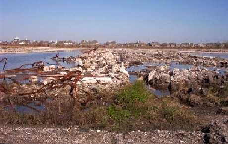
A 2003 photo by David Brooks of the remains of the blimp mooring pad & hangar at Hitchcock.
An impressive 2003 photo by David Brooks of the remains of the former blimp hangar at Hitchcock.
A 2003 photo by David Brooks of the concrete "ribs" which remain of the former blimp hangar at Hitchcock.
A 2003 photo by David Brooks of the remains of the blimp mooring pad at Hitchcock.
A 2003 photo by David Brooks of the former headquarters building at Hitchcock.
David observed: "The building I would refer to as likely a headquarters building is still there & is undergoing restoration by someone.
In the picture, you can see work going on the left side of the building. It appears that either new siding has been applied or paint.
The front with the chipped white paint is what I remember it looking like about 6 months ago."
David Brooks observed, "There are 2 brick building further into the field that are still there.
As you have documented, the hanger was damaged & then torn down.
Whomever owns the place now put in a warehouse that runs the length of the building.
It appears they made use of the 'rib' structure that can be scene on the north side of the field."
"The landing pad is in various levels of disintegration. Some parts are gone & others are not in terrible bad shape.
The old runway is a dirt road now."
David continued, "The main farm road goes through the base. Structures on the northwest side are gone.
Only a single chimney remains & the rest is a horse form & race track. Housing is beginning to be developed in the area.
There are 'new' (not part of the NAS) structures (warehouses, other buildings, a couple of houses) at the field too.
It appears an electrical contractor is using a lot of the warehouse & the landing pad to store electrical equipment.
Lots of junk laying around too."
A 1/31/04 aerial view showed that a small racetrack course had been constructed
over the west side of the primary blimp mooring pad.
Tim Sexton pointed out in 2004 that a company called Blimp Base Enterprises
was using the Hitchcock site to host camping for bike rallies.
A 3/31/06 aerial view showed no significant changes at the site,
with a small racecourse still present on the west side of the primary blimp mooring pad.
Mike Bell reported in 2006 that the site is now operated by GrandSport Speedway,
which hopes to construct a 1.7 mile automobile speedway track on the site of the former Naval Air Station,
using the “hundreds of thousands of tons of gravel, sand and concrete
along with a great site drainage system” left behind by the Navy.
A 2006 aerial photo by Carter Tull, looking south at the remains of the blimp facilities at Hitchcock.
A January 8, 2008 aerial view depicted an expanded racetrack
which had been constructed at some point between 2006-08 over the former blimp mooring pad.
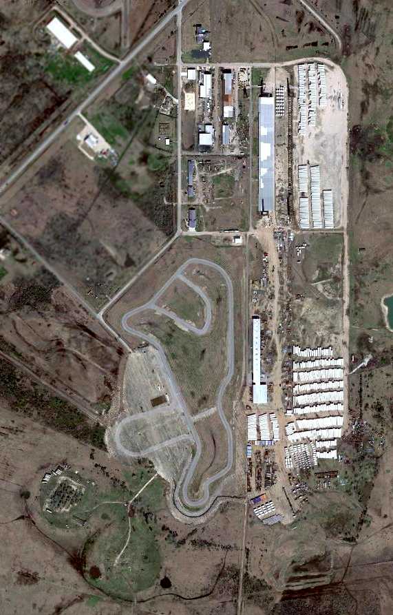
A 2/16/10 aerial view did not appear to show any significant development of the racetrack on the western side of the blimp mooring pad,
but the eastern side was now being used to hundreds of wind turbine towers.

A March 2010 photo by Tom Townsend of the concrete towers which remain from the Hitchcock blimp hangar.
Tom reported that the site “is now some sort of International Trade Zone with nasty no trespassing signs.”
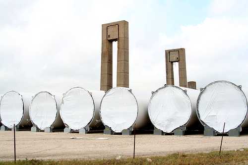
A 5/14/10 view of wind turbine towers stored in front of the Hitchcock blimp hangar remains.
Joe Wilburn of Blimpbase Interests Inc. reported in 2011 that the objects stored on the former blimp pad,
“are wind turbine towers manufactured in Japan & waiting sale.
With the down turn in the economy & lack of government funding there are hundreds of these huge turbines at ports across the country.
We are in the industrial storage business & with the base location & being located out of the flood plain
we have been successful in bringing in some Fortune 500 companies & more so after Hurricane Ike.
The racetrack is to the west of my property & his business continues to grow also.”
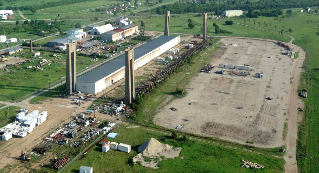
A 7/29/13 aerial view by Joshua Jones looking northwest at the remains of the Hitchcock blimp hangar.
A 2013 photo looking southeast at the remains of the massive Hitchcock blimp hangar.
A 7/6/16 photo by Mark Morgan looking southwest at the remains of the massive Hitchcock blimp hangar.
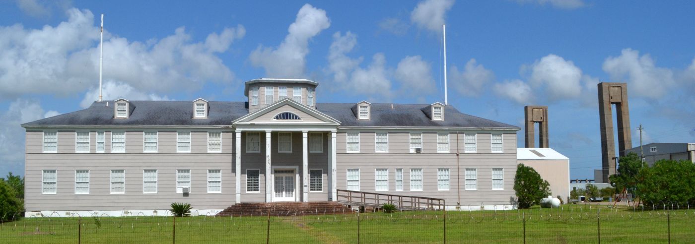
A 7/6/16 photo by Mark Morgan of the former headquarters building at Hitchcock.
Mark observed: "The former station administration/headquarters building is in great shape.
The former Mecom Racing Team (1960s) test track is intact, adjacent to the station & apparently in use with a local group.”
A 2018 3-D aerial view looking southeast at the remains of the massive Hitchcock blimp hangar.
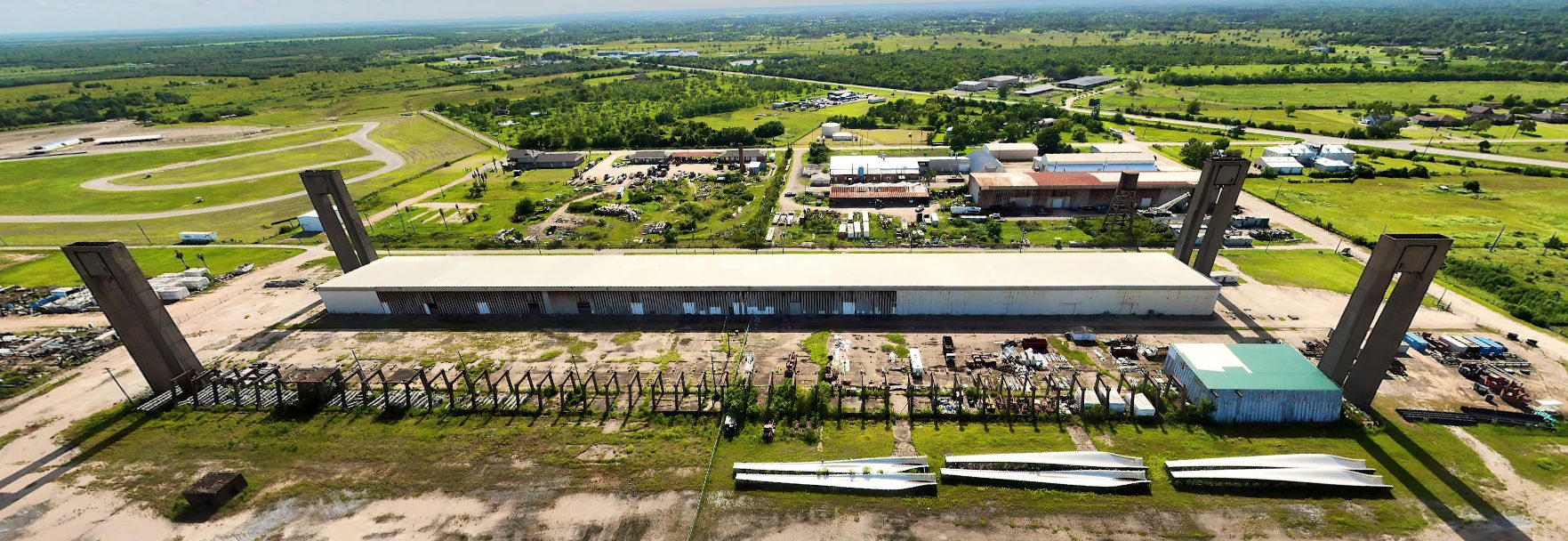
A 2021 aerial view looking west at the remains of the massive Hitchcock blimp hangar.
A 2023 or older photo of a historical plaque erected in 1989 to commemorate NAS Hitchcock.
____________________________________________________
Or if you prefer to contact me directly concerning a contribution (for a mailing address to send a check),
please contact me at: paulandterryfreeman@gmail.com
If you enjoy this web site, please support it with a financial contribution.
Or if you prefer to contact me directly concerning a contribution (for a mailing address to send a check),
please contact me at: paulandterryfreeman@gmail.com
If you enjoy this web site, please support it with a financial contribution.
____________________________________________________
This site covers airfields in all 50 states.