
Abandoned & Little-Known Airfields:
Northeastern Texas
© 2002, © 2024 by Paul Freeman. Revised 11/5/24.
This site covers airfields in all 50 states: Click here for the site's main menu.
____________________________________________________
Please consider a financial contribution to support the continued growth & operation of this site.
Athens Airfield (revised 8/14/24) - Beer Field / Caddo Lake Airport / Fly'N Fish Resort (revised 11/5/24) - Canton-Hackney Airport (added 8/14/24)
Elders Field / Elder Field / (Original) Kilgore Airport (revised 10/25/24) - Lone Star Airport (revised 1/12/24) - (Original) Mount Pleasant Municipal Airport (revised 8/14/24)
Perrin Aux AAF #2 / Gaskin Field / Gaskin Air Force Aux Field (revised 3/2/18) - Stewart Airport (revised 11/5/24) - Wallace Airfield (revised 8/14/24)
____________________________________________________
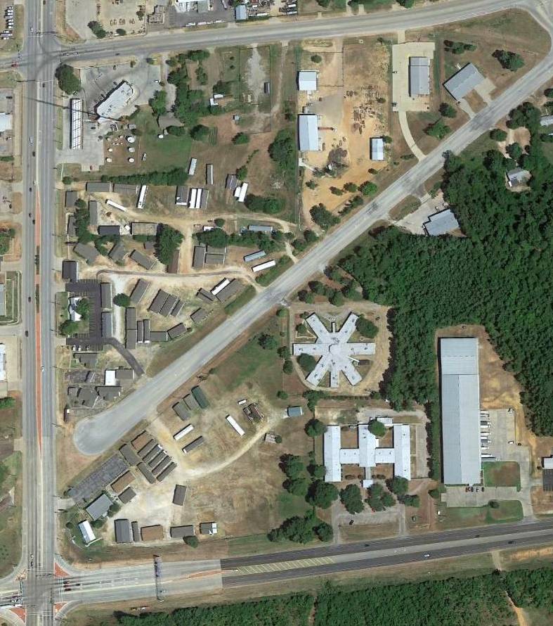
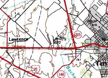
Canton-Hackney Airport (7F5), Canton, TX
32.586, -95.863 (East of Dallas, TX)
Canton-Hackney Airport, as depicted on the 1982 USGS topo map.
Photo of the airport while in use is not available.
This little general aviation airport was evidently established at some point between 1968-82,
as it was not yet depicted on a 1962 aerial photo or the 1968 Shreveport Sectional Chart.
The earliest depiction which has been located of Canton-Hackney Airport was on the 1982 USGS topo map.
It depicted a single unpaved northeast/southwest runway, labeled generically as “Landing Strip”, with 2 small buildings on the southeast side.
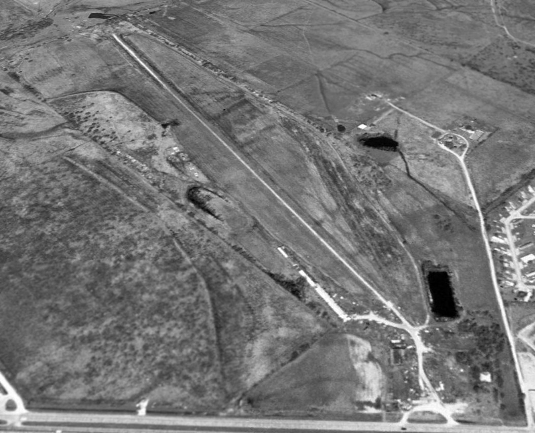
The earliest photo which has been located of Canton-Hackney Airport was a 1982 aerial view.
It depicted a single paved northeast/southwest runway.
Two small buildings & 8 light single-engine aircraft were depicted on the southeast side, apparently showing the airport at the zenith of its popularity.
George Horn recalled, “Canton-Hackney Airport... I was flying for the state of Texas in the 1990s & landed at this airport in a King Air 200 on a flight for Texas Parks & Wildlife.
My passengers (a couple of program directors) were met by a Game Warden & taken to a meeting while I waited a couple hours on the airport.
It had zero amenities & was really quite insufficient for use by a King Air 200 as I could barely manage to find adequate pavement to turn around.
The runway was not excessive, poor condition, and future flights to the area used Van Zandt.”

The earliest photo which is available of Canton-Hackney Airport was a 1995 aerial view looking northwest.
Although the field's physical configuration remained unchanged, it may have already been closed by this point, as in contrast to the 1982 photo, it was devoid of aircraft.

A 3/12/11 photo looking north along Canton-Hackney Airport's rolling runway.
According to Wikipedia, Canton-Hackney Airport was owned by the City of Canton, consisted of 19 acres, and had a single 3,750' asphalt Runway 18/36.
For the year ending 5/11/16, it conducted 600 takeoffs or landings, but had no based aircraft.

A 2019 photo by Randy Coller looking southwest along Canton-Hackney Airport's Runway 18.

A 2019 photo by Randy Coller of Canton-Hackney Airport's displaced threshold lights, of which he remarked, “Colors are all wrong for a displaced threshold.”

The last aeronautical chart depiction which has been located of Canton-Hackney Airport was on the July 2022 DFW Sectional Chart (courtesy of Randy Coller).
It depicted Canton-Hackney as having a 3,700' paved northeast/southwest runway.

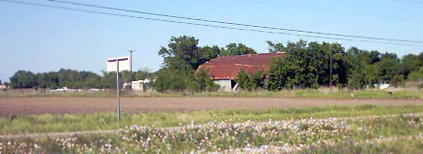
A 10/3/22 photo by Randy Coller of the Canton-Hackney Airport sign.

A photo by Randy Coller of the Canton-Hackney Airport ramp & hangar taken during his 10/3/22 inspection.
Randy reported, “The airport was awful, just like it was 3 years previous to the 10/3/22 inspection.
I met with the DPW director & said that if they couldn't maintain the airport in a safe manner, they might as well close it.
I have a low threshold for the condition of an airport that I would fly into, and this is one that was below my threshold.
I don't like seeing airports close, but when they are a hazard, I feel it is my duty to all pilots to either get conditions corrected or have the airport closed.”

A 10/3/22 photo by Randy Coller of deteriorated pavement at Canton-Hackney Airport.

A 10/3/22 photo by Randy Coller of airport markers between Canton-Hackney Airport & the adjacent golf course.

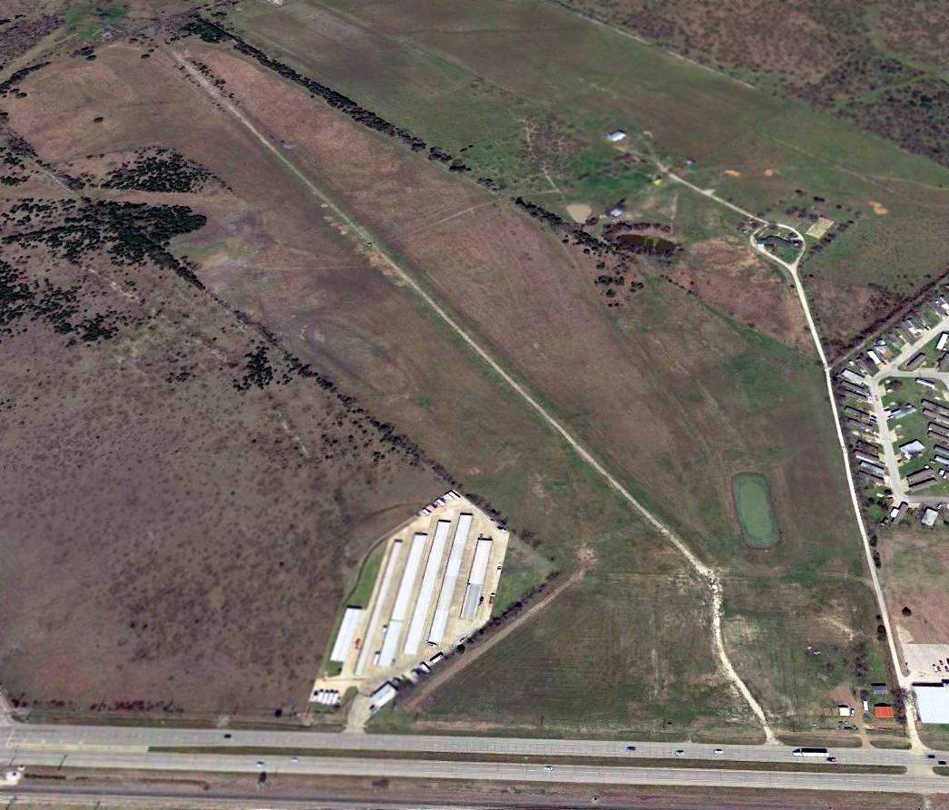
A 2023 photo looking northwest at former runway pavement at the site of Canton-Hackney Airport, showing the hangars had been removed at some point between 2022-2023.
According to the City of Canton website, “As of 11/14/22, the Canton-Hackney Airport is closed.”

A 2024 aerial view looking northwest at the former Canton-Hackney Airport, showing the runway remains intact though deteriorated.
Thanks to Randy Coller for pointing out this airfield.
___________________________________________________
Beer Field / Caddo Lake Airport / Fly'N Fish Resort, Uncertain, TX
32.711, -94.122 (East of Dallas, TX)

Beer Field, as depicted on the February 1951 Shreveport Sectional Chart.
This resort airfield was evidently established at some point between 1950-51,
as it was not yet depicted on a 1949 USGS aerial photo or the August 1950 Shreveport Sectional Chart.
The earliest depiction which has been located of Beer Field was on the February 1951 Shreveport Sectional Chart.
It depicted Beer Field as having a 4,800' unpaved runway.
According to Pud Harper, his father, Beer Smith, operated the Fly 'n Fish Resort on Caddo Lake in the early 1950s.
“The Fly 'n Fish was a 20-room motel that had a large dining area downstairs," Pud said.
"Upstairs it had a ballroom with a stage that could be lowered or raised. On the other end of that was a bar.
People would fly their private planes in, and we had a hangar where they could leave them. Across the street, he built a huge pier.”

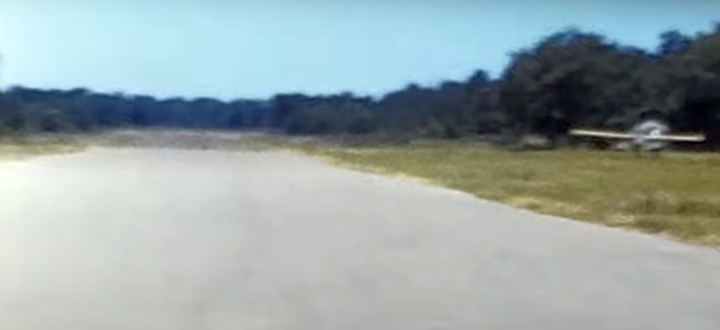
The earliest photo which has been located of Beer Field was an 8/7/57 USGS aerial view.
It depicted Beer Field as having a paved northwest/southeast runway, with a hangar, the lodge building, 1 light single-engine plane on the south side.
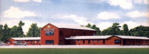
A circa 1950s colorized postcard photo of 2 single-engine planes parked in front of the Fly'N Fish resort.
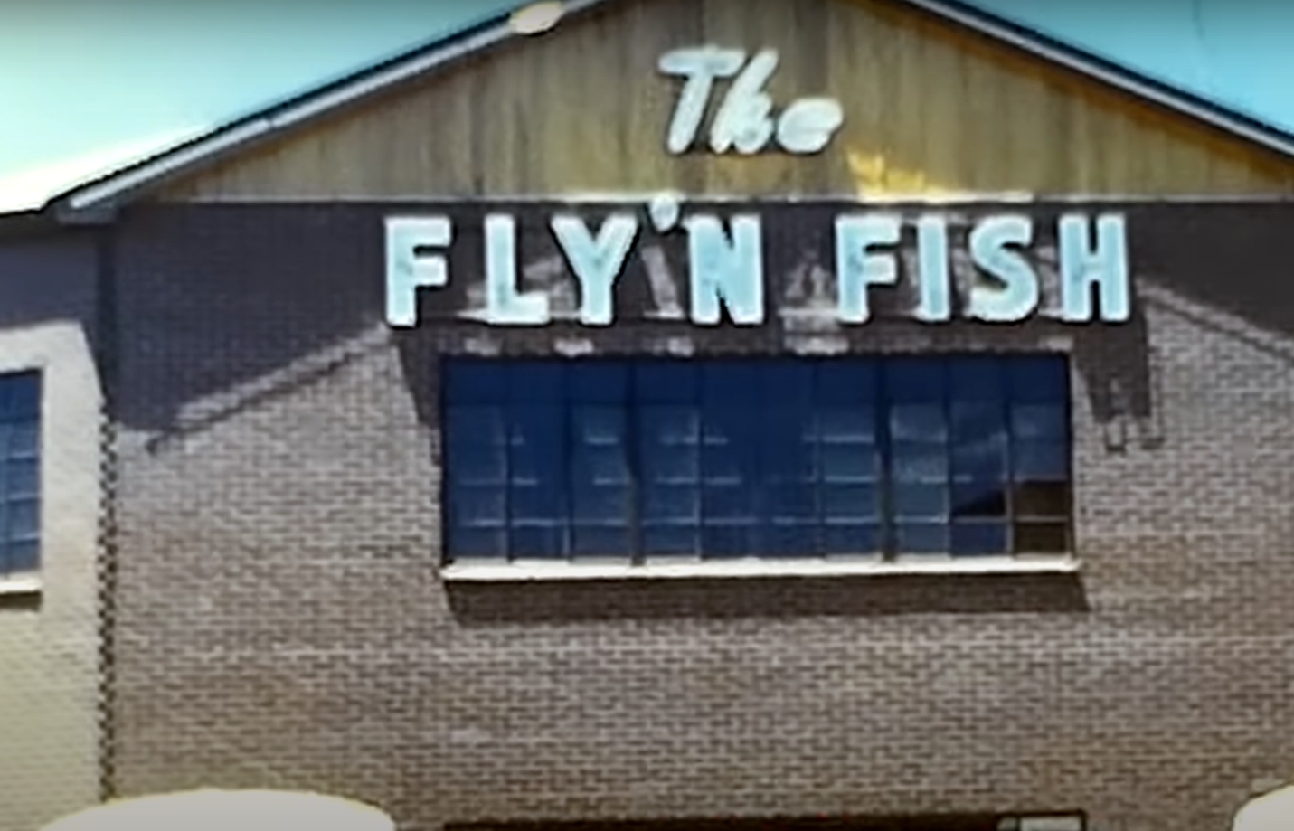
A still from a circa 1950s movie of the Fly'N Fish resort.
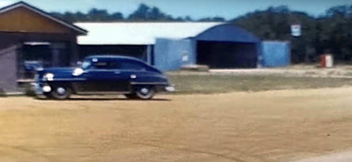
A still from a circa 1950s movie of an arch-roof hangar at the Fly'N Fish resort.
A still from a circa 1950s movie of a Bellanca parked at the Fly'N Fish resort.
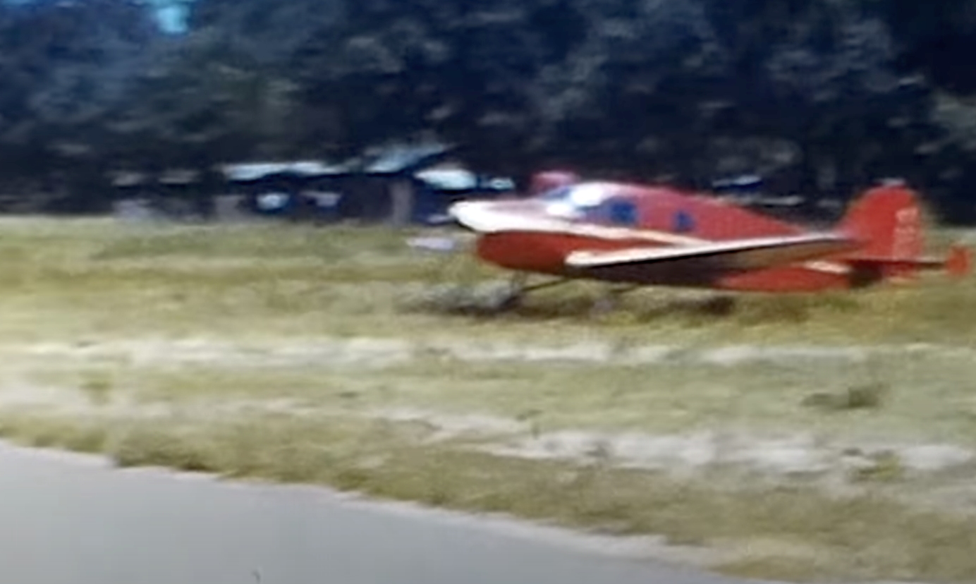
A still from a circa 1950s movie of a light single-engine plane parked next to the runway at the Fly'N Fish resort.
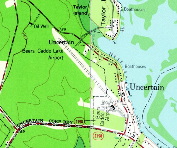
The 1962 USGS topo map depicted “Beers Caddo Lake Airport” as having an unpaved northwest/southeast runway, with the lodge building on the south side.
George Horn recalled, “In 1967/68 I was a student at SFA College & my roommate was a private pilot who steered me into flying.
We took a rented Cessna 150 over to Beers Caddo Lake & spent some time wandering around in the old hotel.
One of the locals gave us a volunteer tour & told us of grand parties & dinner/dance celebrations during the days of 'dry counties' & the last days of 'big band era' dances held in the upstairs ballroom.
The building was in deteriorated & peeling-paint condition & the runway was not in the best condition either.”
The last aeronautical chart depiction which has been located of Beer Field was on the June 1968 Shreveport Sectional Chart.
It depicted Beer Caddo Lake Airport as having a 4,100' paved northwest/southeast runway.
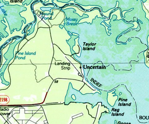
The 1986 USGS topo map depicted Beer Field as having a northwest/southeast runway,
labeled generically as “Landing Strip”, which typically meant the airport was closed by that point.
A 1989 aerial view showed Beer Field remained intact, including the runway, hangar, and lodge building, but there were no aircraft visible on the field.
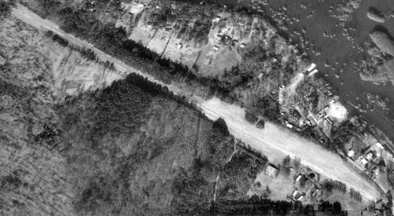
A 1994 aerial view looking northeast showed Beer Field remained intact, including the runway, hangar, and lodge building, but there were no aircraft visible on the field.
A 2006 aerial view showed the wooden lodging buildings on either side of the Fly'N Fish lodge building had been removed.

A 5/22/10 photo looking west at the 2-story brick portion which remains of the Fly'N Fish lodge building, with the wooden lodging buildings on either side having been removed.
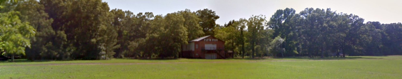
A June 2016 photo looking west at Beer Field, showing the central portion of the Fly'N Fish lodge building.
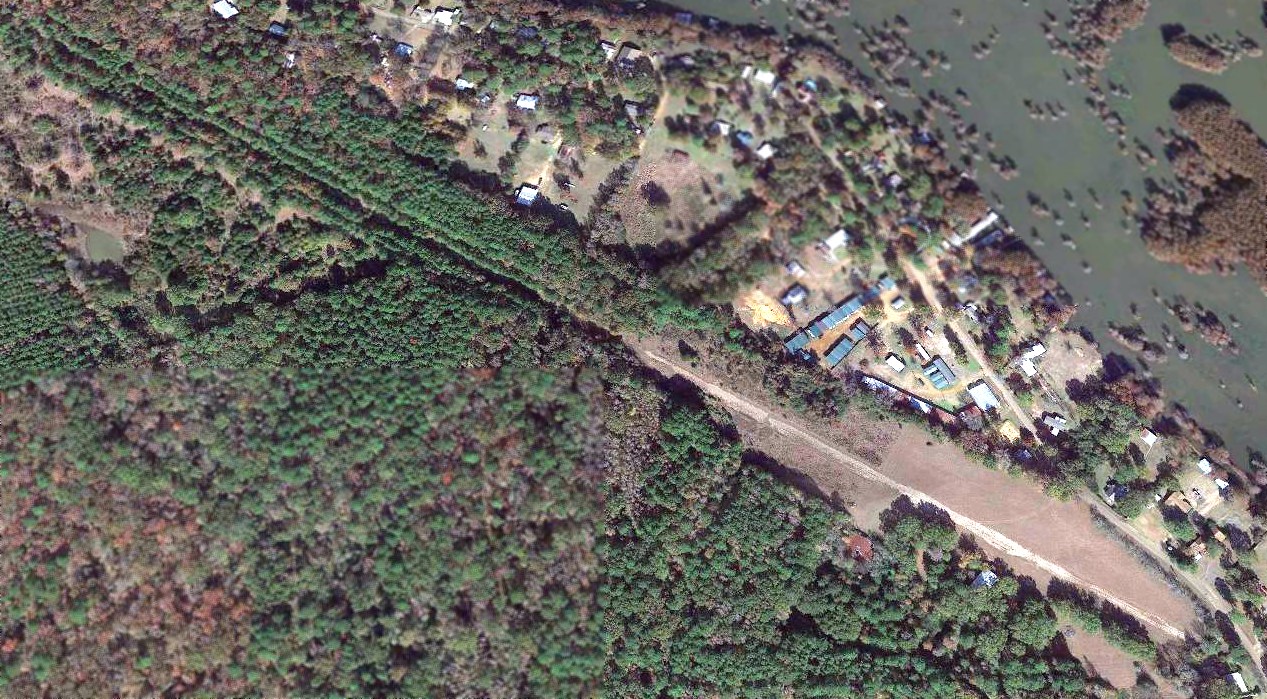
A 2019 aerial view looking northeast at Beer Field showed the runway remained intact though deteriorated,
along with the hangar & the central portion of the Fly'N Fish lodge building.
Thanks to John Knight for pointing out this airfield.
___________________________________________________
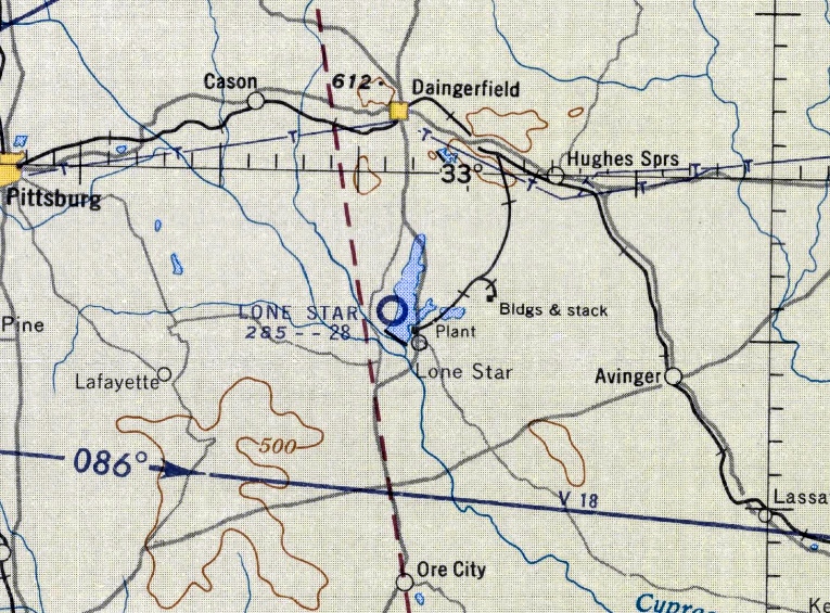
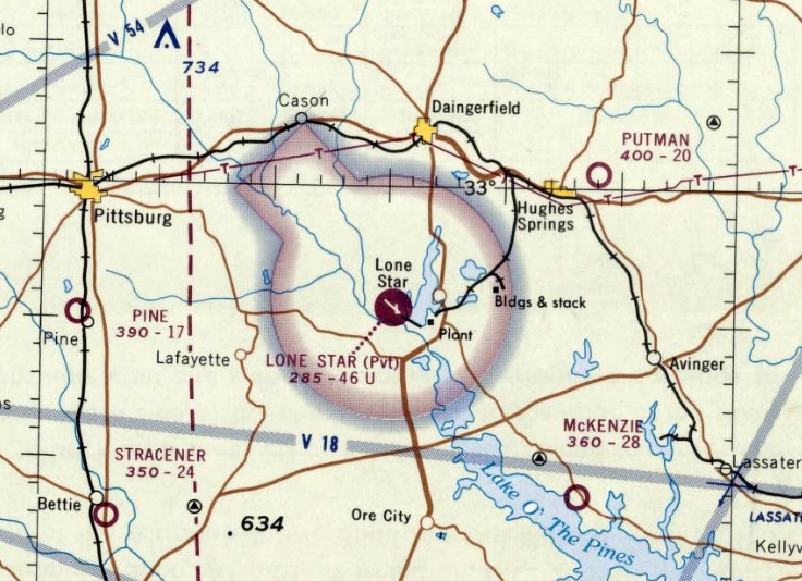
Lone Star Airport (4TE0), Lone Star, TX
32.93, -94.741 (East of Dallas, TX)
Lone Star Airfield, as depicted on the August 1956 Shreveport Sectional Chart.
Photo of the airfield while in use has not been located.
This private airfield was evidently established at some point between 1955-55,
as it was not yet depicted on the August 1955 Shreveport Sectional Chart.
The earliest depiction which has been located of Lone Star Airport was a 1955 aerial view,
which depicted a single asphalt north/south runway directly adjacent to the west shore of the lake.
The Lone Star Airport was evidently built to support the Lone Star Steel mill, adjacent to the southeast.
The earliest aeronautical chart depiction which has been located of Lone Star Airport was on the August 1956 Shreveport Sectional Chart.
It depicted Lone Star as having a 2,800' unpaved runway.
A 1957 aerial view depicted Lone Star Airport in an unchanged configuration.
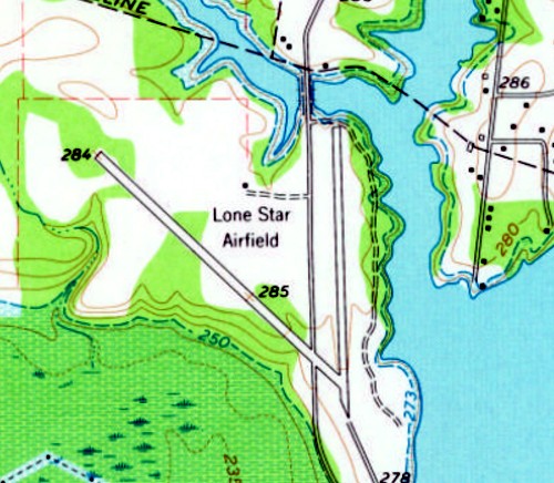
The earliest topo map depiction which has been located of Lone Star Airport was on the 1962 USGS topo map.
It depicted “Lone Star Airfield” as having 2 paved runways, with a northwest/southeast runway having been added at some point between 1957-65.
A single small building was depicted to the northwest of the runway intersection.
According to former Fort Worth Center controller David Benedetto, “Lone Star Steel Airport even had a private IFR approach.
I recall having the pilots tell us 'Runway clear of cattle', funny.”
The last aeronautical chart depiction which has been located of Lone Star Airport was on the June 1968 Shreveport Sectional Chart.
It depicted Lone Star as a private airfield having 2 paved runways, with the longest being the 4,600' northwest/southeast strip.
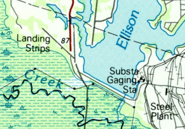
The 1984 USGS topo map depicted Lone Star Airport as 2 runways, labeled simply as “Landing Strips”.
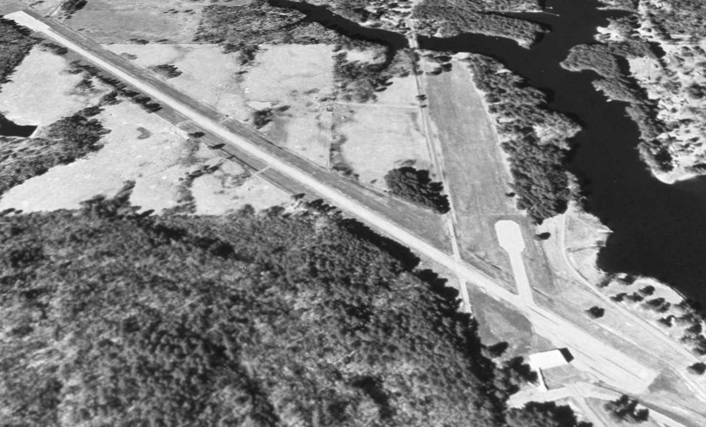
The earliest photo which has been located of Lone Star Airport was a 1995 USGS aerial view looking north.
It showed Lone Star Steel to have a paved northwest/southeast airport, and a grass north/south runway.
A single small hangar sat at the southeast end.
Tommy Hudson recalled, “I flew a Cessna 310 into Lone Star Airport during the late 1990s for business meetings with Lone Star Steel.
I can confirm the existence of a Non-Directional Beacon instrument approach which I used to assist our landing in bad weather.
As I recall, the approach was from the West.
When an inbound flight was anticipated a security guard would respond to a radio call on the Unicom frequency.
When the flight came into view nearing the runway the guard would lower crossings to block traffic on the county road to allow the landing aircraft full runway length.
The Long Star Airport enabled great convenience when visiting the mill!”
Lone Star Airport was evidently closed (for reasons unknown) at some point between the late 1990s & 2015, as a 2015 aerial view looking north shows the paved runway marked with closed-runway “X” symbols.
As of 2017, sectional charts depicted Lone Star Airport as an abandoned airfield.
Lone Star Airport is located north of Airstrip Road, appropriately enough.
Thanks to David Benedetto for pointing out this airfield.
___________________________________________________
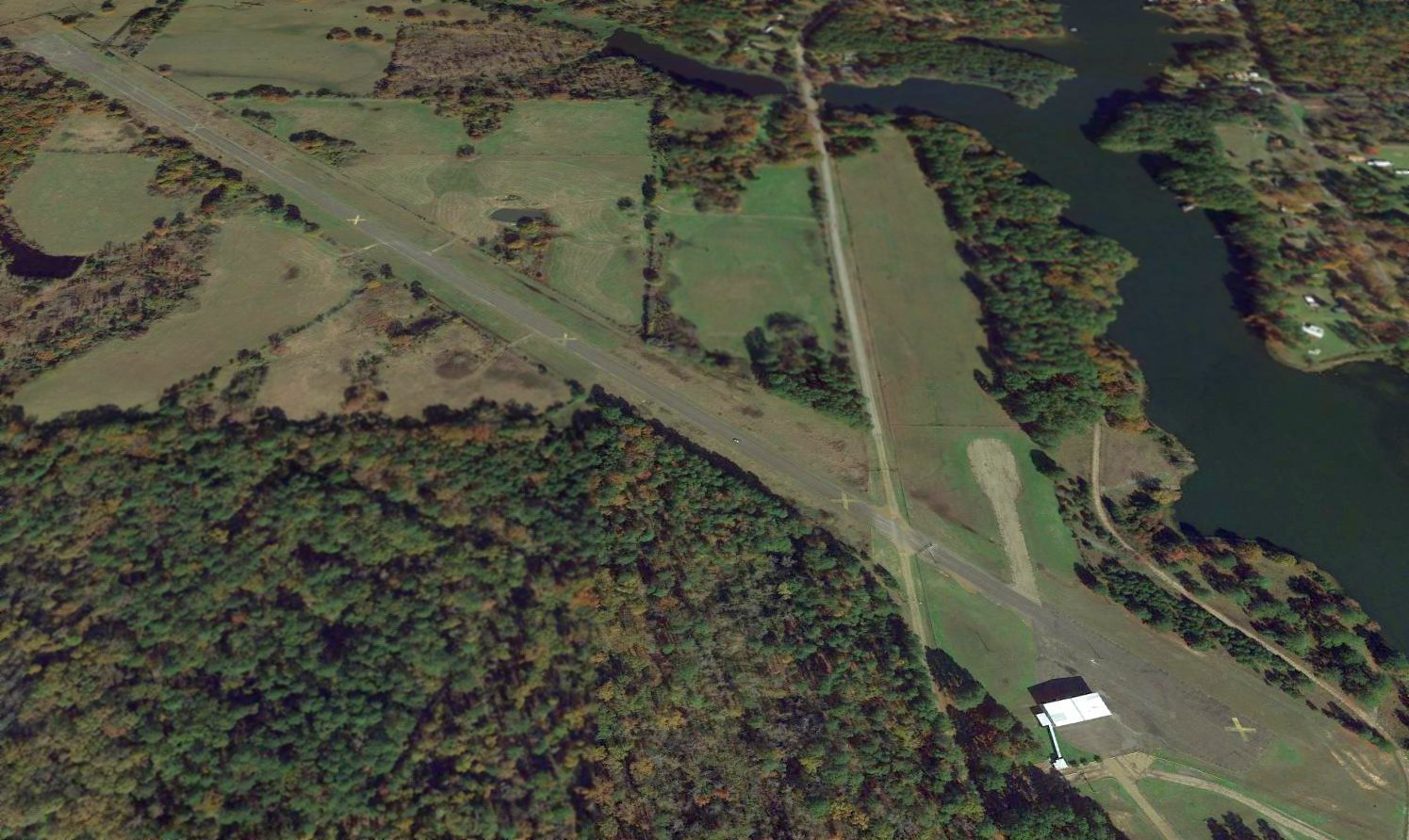
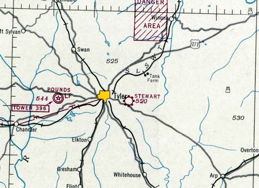
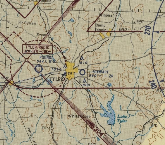
32.351, -95.266 (Southeast of Dallas, TX)
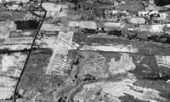
A 10/17/43 aerial view looking north at Stewart Airport from the 1945 AAF Airfield Directory (courtesy of Scott Murdock).
It depicted “Elders Field” as having 3 unpaved runways.
This small general aviation airport on the east side of Tyler was evidently established at some point between 1942-43,
as it was not yet depicted on the August 1942 Shreveport Sectional Chart.
According to Tyler Texas Online, “Stewart Airport was begun about 1942 in the east section of Tyler by Walter Stewart, and was 113 acres.
Stewart's airport featured a 2,500' north/south runway & a 1,900' east/west runway; both were grass & sand.”
The earliest depiction which has been located of Stewart Airport was a 10/17/43 aerial view looking north from the 1945 AAF Airfield Directory (courtesy of Scott Murdock).
The directory described Stewart Airport as a 113 acre irregularly-shaped property having 2 sand & sod runways, measuring 2,500' north/south & 1,900' east/west.
The field was said to have 2 hangars, the largest measuring 120' x 80', and to be owned & operated by private interests.
The earliest aeronautical chart depiction which has been located of Stewart Airport was on the March 1944 Shreveport Sectional Chart.
It depicted Stewart as a commercial/municipal airport.
According to Tyler resident Randy Gilbert, “Right after the war [WW2], a firm set up a plant to build the 'Texas Bluebird' airplane,
but I don’t think that they ever got off the ground.
Someone gave a program on it at our historical society. The plant building was on the north side of Erwin Street & the east side of the loop.
There was also a long narrow building that was oriented northwest/southeast
that was about about 200' east of the loop & 500' south of East Erwin that was reportedly associated with the field.”

A 2/15/47 USGS aerial photo showed Stewart Airport as having 3 unpaved runways,
with 4 light single-engine aircraft visible near the buildings on the northwest corner.
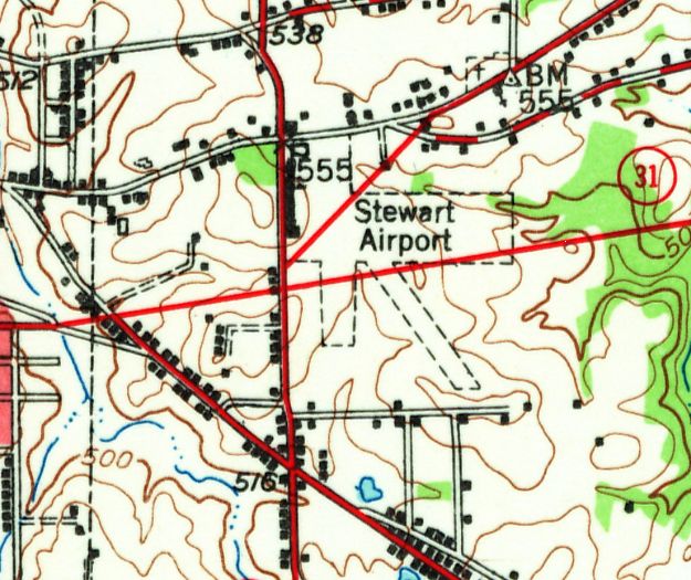
The 1948 USGS topo map depicted Stewart Airport as having 3 unpaved runways, with a long building along the road on the west side.
The last aeronautical chart depiction which has been located of Stewart Airport was on the August 1952 Shreveport Sectional Chart.
It depicted Stewart as having a 2,400' unpaved runway.
Stewart Airport was evidently closed (for reasons unknown) at some point between 1952-53,
as it was no longer depicted on the February 1953 Shreveport Sectional Chart.
According to Tyler Texas Online, “Television station KLTV began broadcasting in 1954, and was originally located on East Erwin Street at Loop 323 in a former hangar at Stewart Airport.”

The last photo which is available of the former Stewart Airport hangar was a circa 1950s photo, showing it reused as the KLTV studios (with their KLTV tower seen in the background).
A 1958 aerial photo showed Stewart Airport's hangars & runways remained intact, but abandoned & deteriorated.
A 1960 aerial photo showed the 323 Loop having been built through the Stewart Airport property,
but several hangars & airport buildings remained standing on the northwest portion of the airport site.
According to Tyler Texas Online, “In 1996, KLTV relocated its operations from its longtime studios on East Erwin to a new facility downtown.”
Tyler resident Randy Gilbert reported, “The 'Texas Bluebird' plant building remained until about 10 years ago [2006] when it burned.”
According to Tyler Texas Online, “The [former] Stewart Airport hangar was demolished in November 2007.”
A 2015 aerial view showed no recognizable trace remaining of Stewart Airport.
The site of Stewart Airport is located southeast of the intersection of East Erwin Street & 323 Loop.
Thanks to Randy Gilbert for pointing out this airfield.
___________________________________________________
32.16, -95.86 (Southeast of Dallas, TX)
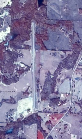
Athens Airfield, as depicted on an 11/13/82 aerial view.
Not much is known about this apparent private airfield located due south of the town of Athens, including its name or purpose.
This airfield was evidently constructed at some point between 1955-76,
as it was not yet depicted on a 1955 aerial photo or the June 1968 Shreveport Sectional Chart.
The earliest depiction which has been located of the Athens Airfield was a 1976 aerial photo,
which depicted a single north/south runway, but with no hangars or aircraft.
The earliest depiction which is available of the Athens Airfield was an 11/13/82 aerial photo,
which depicted a single 5,000' asphalt north/south runway.
The 1984 USGS topo map depicted a single north/south runway at Athens, labeled simply as “Landing Strip”.
A 2/2/95 USGS aerial view looking northwest at the Athens Airfield.
As of 2014 no airfield was listed with the FAA at the location of the Athens Airfield, nor was it depicted on the 2016 DFW Sectional Chart.

A 2022 aerial view looking northwest showed the Athens runway as remaining intact though considerably deteriorated.
The site of Athens Airfield is located west of the intersection of Stonebridge & Route 753.
___________________________________________________
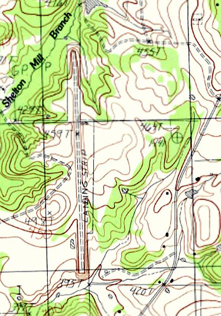
Elders Field / Elder Field / (Original) Kilgore Airport, Kilgore, TX
32.41, -94.85 (East of Dallas, TX)

A postmark commemorating the 10/22/33 dedication of “Elders Field” (courtesy of Greg Patterson).
This small general aviation airport on the northeast side of Kilgore was dedicated on 10/22/33,
according to a commemorative postmark (courtesy of Greg Patterson).
The earliest depiction of which has been located of Elder Field was on the 1934 Shreveport Sectional Chart (courtesy of Greg Patterson).
It depicted “Kilgore” as an auxiliary airfield.
A 1936 TX Highway Map (courtesy of Greg Patterson) depicted “Elder's Fort Airport” as an open area with buildings along the southern periphery.
A circa 1930s/40s aerial view by Jack Elder (courtesy of Ginger Elder Cannon) depicted Elder Field as having a paved (or oiled) northeast/southwest runway, with a shorter unpaved east/west runway.
A dozen light single-engine planes were visible parked near 2 small buildings on the southwest corner.
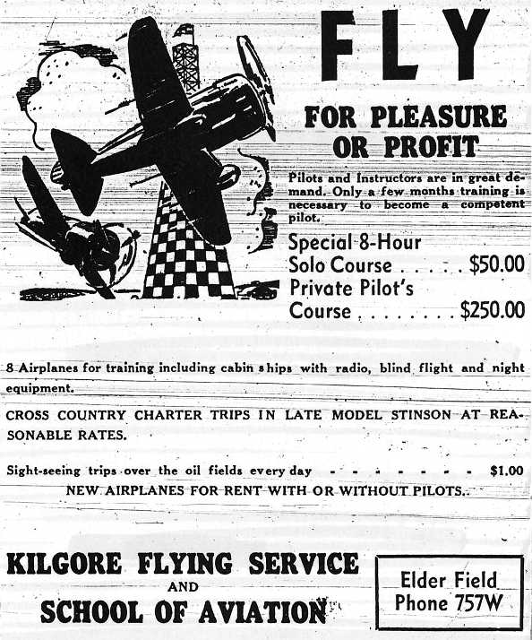
A 5/18/41 advertisement (courtesy of Greg Patterson) for Kilgore Flying Service & School of Aviation.
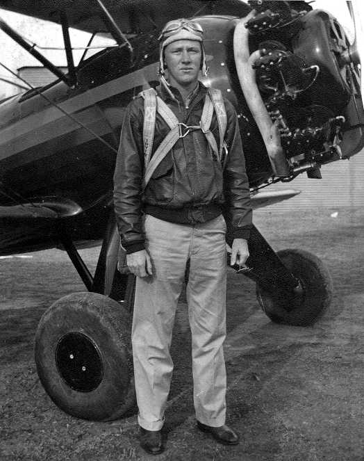
A 1943 photo (courtesy of Greg Patterson) of Civilian Pilot Training Program instructor H.E. Patterson
in front of a Waco biplane trainer at Elder Field.
Greg Patterson recalled, “My father H. E. Patterson was a Civilian Pilot Training Program instructor at Elder Field from 1942-44.
The Elder Field CPT program was associated with Kilgore Junior College.”
A 5/23/43 advertisement (courtesy of Greg Patterson) for Kilgore Flying Service & School of Aviation.
An undated photo of a line of Piper Cubs from a 5/23/43 advertisement (courtesy of Greg Patterson) for Kilgore Flying Service & School of Aviation.
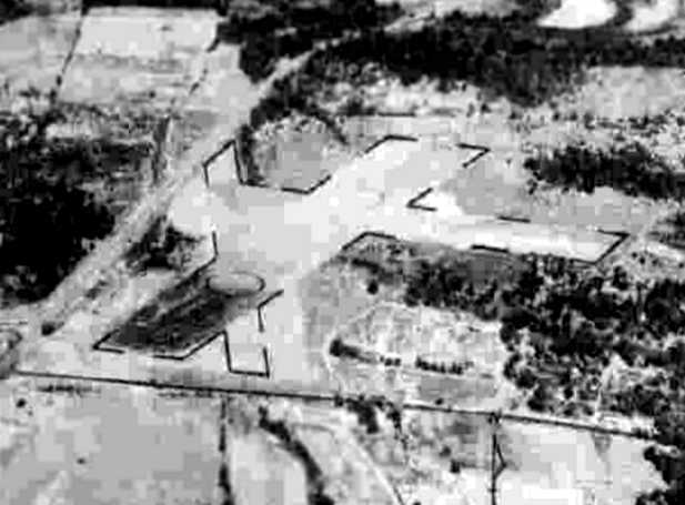
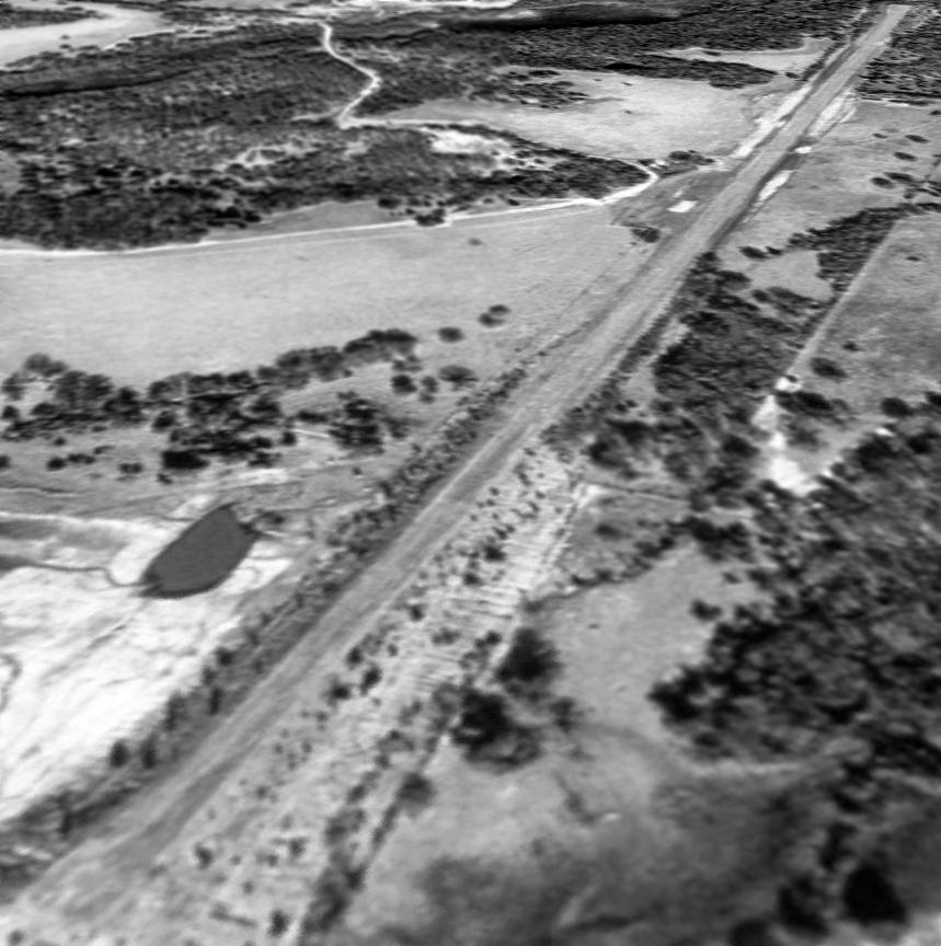
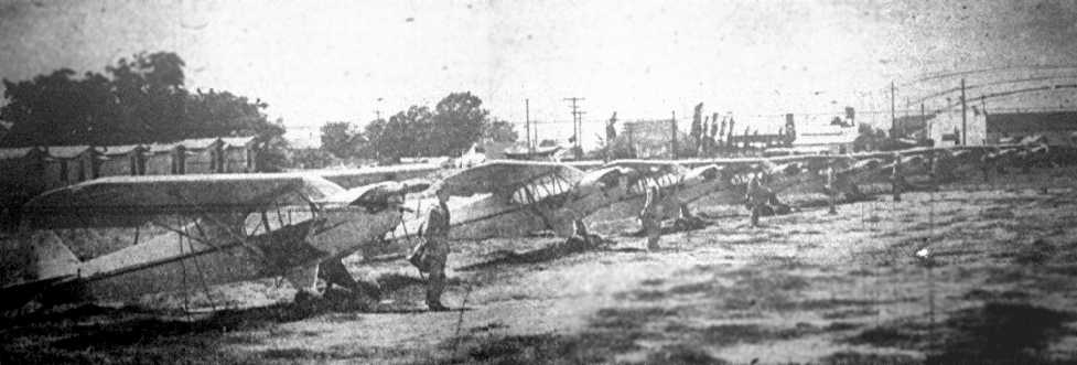
The last photo which has been located of Elder Field
was a 10/17/43 aerial view looking north from the 1945 AAF Airfield Directory (courtesy of Scott Murdock).
It depicted “Elders Field” as having 3 unpaved runways.
The 1943 Sectional Chart (courtesy of Greg Patterson) depicted Elder as a commercial/municipal airport.
The 1945 AAF Airfield Directory (courtesy of Scott Murdock) described “Elders Field”
as a 200 acre L-shaped property having 3 sod & dirt runways, the longest measuring 2,650' NNE/SSW.
The field was said to have 4 wood & metal hangars, the largest measuring 120' x 90',
and to be owned & operated by private interests.
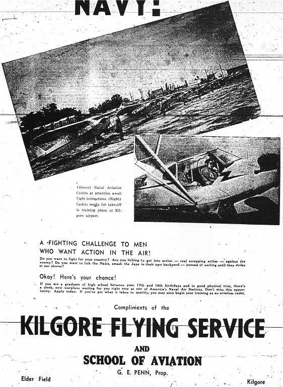
According to Greg Patterson, “Elder Field's Fixed Base Operator G. E. Penn moved his operation to the New Gregg County Airport when it opened on 7/14/47.
Brent Henneman reported, his airplane, “a 1947 Stinson 108-1... its original owners were Kilgore Flying Service"out of Elders Field.”

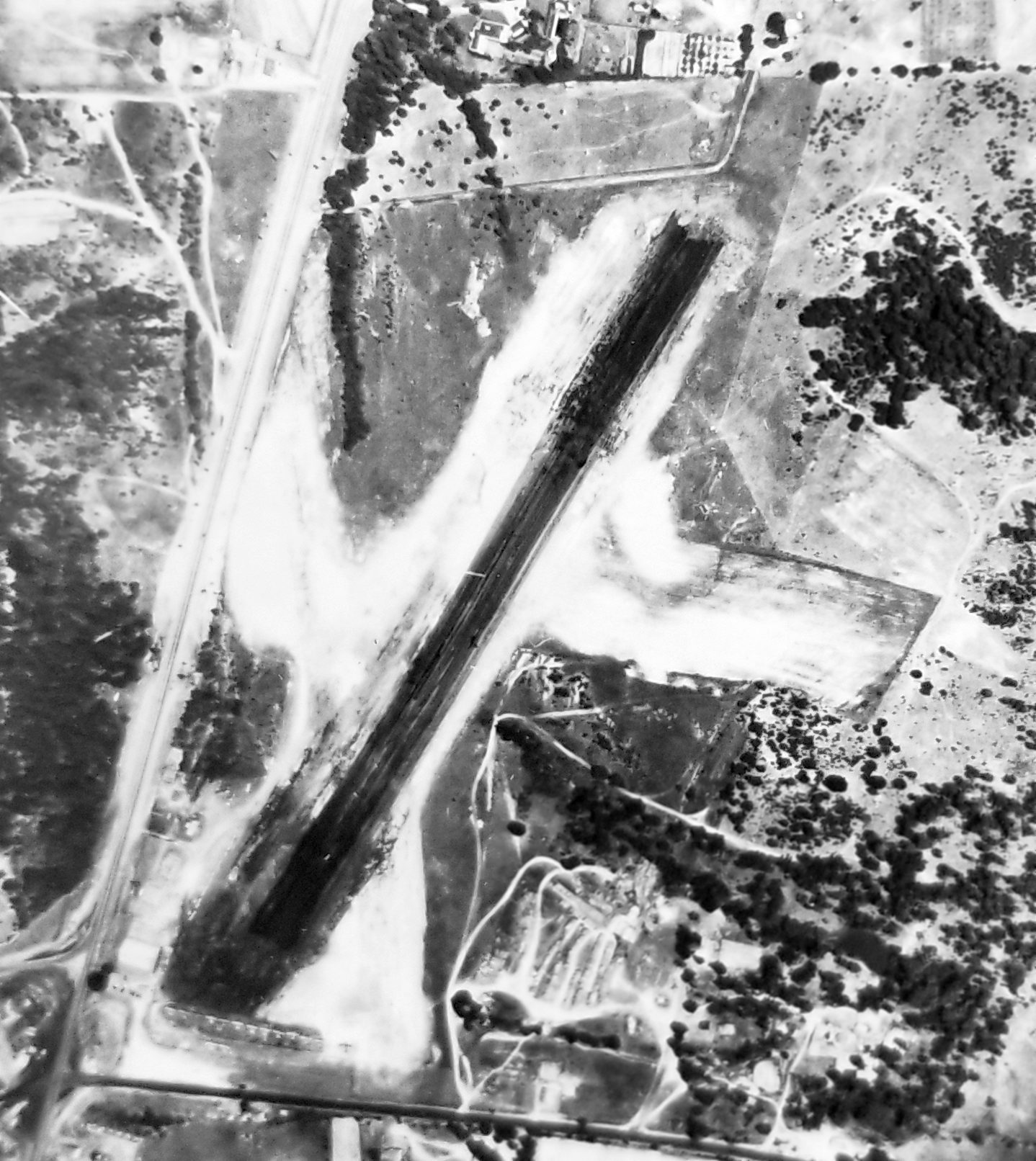
The last photo which is available showing Elder Field while it was open was an 11/1/49 USGS aerial view.
It depicted Elder Field's runway & hangars as remaining intact, but there were no aircraft visible on the field
Donald Martin recalled, “Elder Field... I worked there as a teen-age operations assistant in the summers of 1952, 1953, and 1954 & earned my Private License in payment.
The field was managed by Don Malarkey & his wife Vera. They were professional golfers & were away a great deal of the time leaving me as the sole operator.
It was a teenager's dream & my duties were everything from pumping gas, sweeping hangars, washing & waxing airplanes,
operating the office, and running the golf driving range located at the south end of the field.
We operated a Piper Cruiser, a Taylorcraft, 2 J-3 Cubs, a Cessna 120 & 140, and a Stinson Voyager.
My first logbook entry [at Elder Field] was 6/10/52 in Piper 2414M.”
The last aeronautical chart depiction of which has been located of Elder Field was on the September 1953 Shreveport Sectional Chart.
It depicted “Elders” as having a 2,600' unpaved runway.
A 1954 aerial photo showed Elder Field's runway & hangars remained intact, but there were no aircraft visible on the field
Donald Martin recalled, “My last [flight at Elder Field] was 12/16/54 in Piper 2414M.
I left Kilgore in January 1955 & understand the field closed shortly thereafter.”
Elder Field was evidently closed at some point between 1954-55,
as it was no longer depicted on the August 1955 Shreveport Sectional Chart.
A 1970 aerial photo showed the remains of a northeast/southwest runway at the site of Elder Field.
Greg Patterson recalled, “My dad often pointed out the location of the field.
In 1970 it was grown over with small pine trees,
however we still found the concrete foundations for T-hangars northeast of the intersection of Highway 31 & Highway 349.”
Shayne Rogers reported, “I've got a 1978-79 aerial [photo]... amazingly the main runway was still wide open & barren!”
Greg Patterson recalled, “Into the 1980s the tree my dad pointed out, as the tree student pilot Menasco crashed a Waco trainer into in 1941, was still standing.
This large tree was near the old highway, now in a Halliburton oilfield services yard.”
The 1995 USGS aerial photo shows that a large retaining pond of some type occupied the majority of the airport property.
Greg Patterson recalled, “About 10-15 years ago [2008-2013]
the T-hangar foundations were bulldozed out of the way for a City of Kilgore storage yard.”
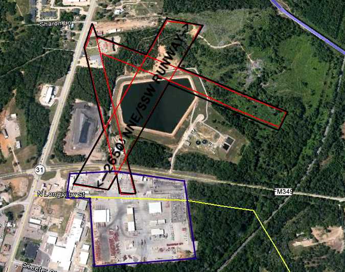
A 4/22/12 aerial annotated by Shayne Rogers to show the location of the Edler runways.
It does not appear to show any remaining trace of Elder Field.
Shayne observed, “FM 349 was not there in 1933- 1940s, it couldn't have been.
Highway 259 (north & south) is still right to the west of the former airfield & it lines up with the 1943 aerial picture.
After studying the topography, and the lay of the facilities (Halliburton Yard) that is just across FM 349 from the site,
I have determined that the west entrance to Halliburton, off Highway 259- is that old road.
Halliburton 'consumed' that road & just east of Halliburton's yard - you can see the remnants
(difference in terrain...old right of ways, old road beds, etc., and if you compare my picture to the sectional chart - everything lines up, even the railroad.”
A 6/21/13 photo by Shayne Rogers looking southwest along the northwest/southeast runway.
Shayne observed, “It's all younger tree growth so I am confident this picture is about the middle of the runway.”
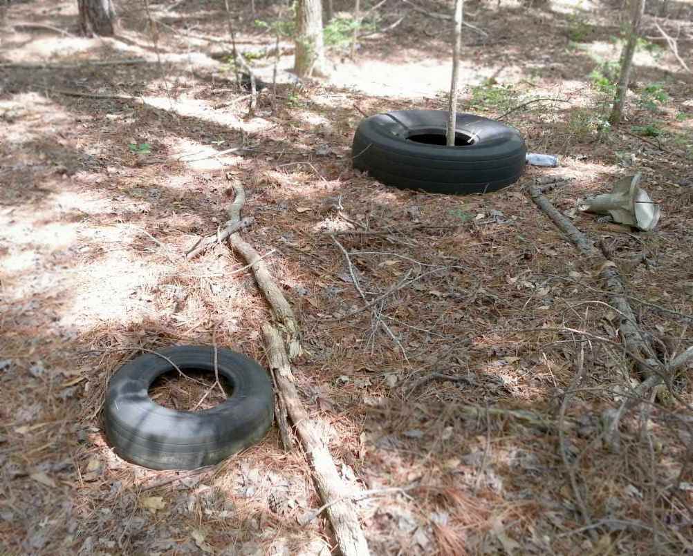
A 6/21/13 photo by Shayne Rogers of 2 Goodyear aircraft tires at the site of Elder Field.
Shayne observed, “I was walking the woods & stumbled on 3 aircraft tires...who'd a thunk it?
There was localized rubble piles with concrete in them- it was really full of gravel & had older style rebar in it... looks almost like runners/footings for t-hangars.”
Ginger Elder Cannon reported in 2019 that the site of Elder Field “is now owned by the City of Kilgore... Elder Lake at Synergy Park.”
The site of Elder Field is located northeast of the intersection of Route 31 & Route 259.
___________________________________________________
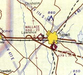
32.74, -96.32 (East of Dallas, TX)
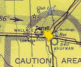
Wallace Airfield, as depicted on the February 1943 Dallas Sectional Chart (courtesy of Chris Kennedy).
The date of establishment of this small general aviation field has not been determined.
No airfield at this location was depicted on the September 1942 Dallas Sectional Chart (according to Chris Kennedy).
Barbara Wallace Simandl reported, “I am the granddaughter of one of the prior owners of the Wallace airport.
The information I have heard is that my father, James Wallace, and one or two of his brothers ran this airport.
I believe it was in existence prior to 1943 but am not sure.”
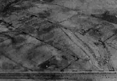
The earliest depiction of Wallace Airfield which has been located was on the February 1943 Dallas Sectional Chart (courtesy of Chris Kennedy).
It depicted Wallace as a commercial/municipal field.
The earliest photo which has been located of Wallace Field
was a 10/21/43 aerial view looking north from the 1945 AAF Airfield Directory (courtesy of Scott Murdock).
It depicted Wallace as having an unpaved runway.
The 1945 AAF Airfield Directory (courtesy of Scott Murdock) described Wallace Field
as a 98 acre irregularly-shaped property within which was a 1,850' sod runway within a 2,100' x 1,200' sod all-way landing area.
Wallace was said to have a single 80' x 60' wood hangar, and to be owned & operated by private interests.

A 9/15/61 USGS aerial photo depicted Wallace Field as having a single unpaved northwest/southeast runway, with a hangar on the south end.
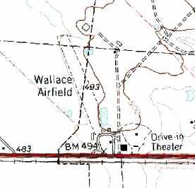
The 1963 USGS topo map depicted “Wallace Airfield” as having a single unpaved northwest/southeast runway.
Steve Harkins recalled, “I remember driving past there as a kid in the 1960s, and seeing airplanes taking off & landing.”
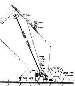
The 1965 DFW Sectional Chart described Wallace Airfield as having a single 2,365' turf runway.
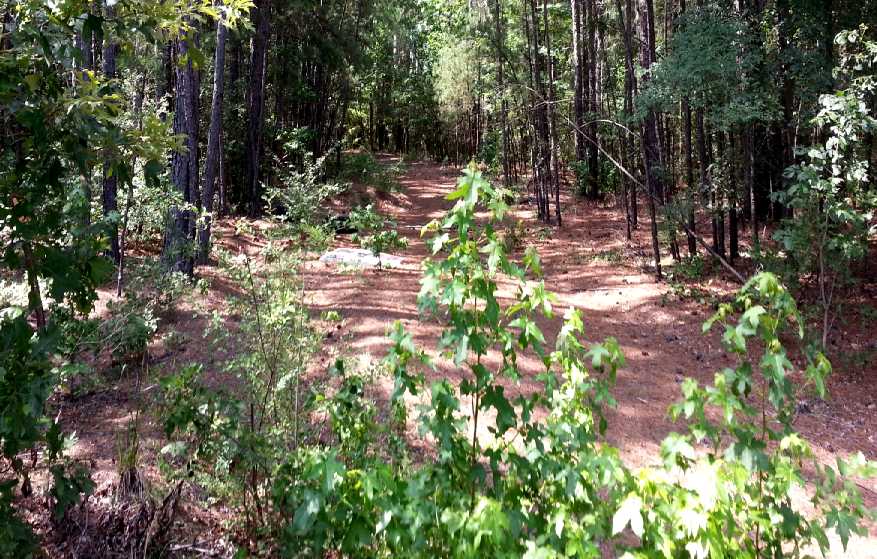
John Criswell recalled, “It had a short strip with a few T-hangars on the Northeast side.
The approach from the South had to be pretty steep because of a drive-in theater located just across Highway 80 which cut across the threshold of the runway.
I got my ticket in 1965 at Dallas Redbird and remember one of my solo flights included a quick stop at Terrell.
The last time I was there, now many years ago, there was still a Stinson Voyager on the field, but not much else.
A strange being lived in a small travel trailer alongside the open-air hangars
and he used to just sit in a beat-up folding lawn chair in the shade watching.”
The 1967 TX Airport Directory (courtesy of Brad Stanford) depicted Wallace Airfield as consisting of a single 2,365' turf Runway 15/33.
The manager was listed as Matthew Wallace.
The airfield configuration was unchanged in the 1970 TX Airport Directory (courtesy of Ray Brindle).
The July 1983 Dallas-Ft Worth Sectional Chart (courtesy of Chris Kennedy) still depicted Wallace as a public-use airfield with a 3,500' unpaved runway.
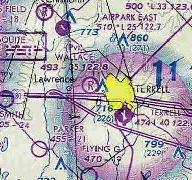
At some point between 1983-85, Wallace apparently became a private airfield,
as that is how it was depicted on the July 1985 Dallas-Ft Worth Sectional Chart (courtesy of Chris Kennedy).
The runway was still depicted on the 1986 USGS topo map,
but it was labeled simply as “Landing Strip”, which may have indicated that the field had closed by that point.
Wallace Airfield was definitely closed by 1987, as it was no longer depicted at all on the July 1987 CG-20 World Aeronautical Chart (according to Chris Kennedy).
A 1995 USGS aerial view looking north showed the area of the former Wallace Field runway was still clear,
but the site was otherwise unrecognizable as a former airport.
A Spring 2004 photo by Joe Hancock, looking north from Route 80 at the former Wallace hangar.
Joe observed, “I assume this old rusty hangar is about all that's left of it.
The old hangar used to have a sign reading 'Wallace Airfield, Matthew Wallace owner'. I saw it many times passing on Highway 80.”
Steve Harkins reported in 2006, “The now-rusty main hangar building at the old Wallace Airfield is still standing as of this past week.”
A circa 2006 aerial photo still showed the hangar standing.
However, a 2007 photo showed that the hangar had been removed, but the runway area remained clear.
A 2014 aerial view looking north showed the runway area of Wallace Field remained clear,
The site of Wallace Airfield is located northeast of the intersection of Route 80 & Route 237.
___________________________________________________
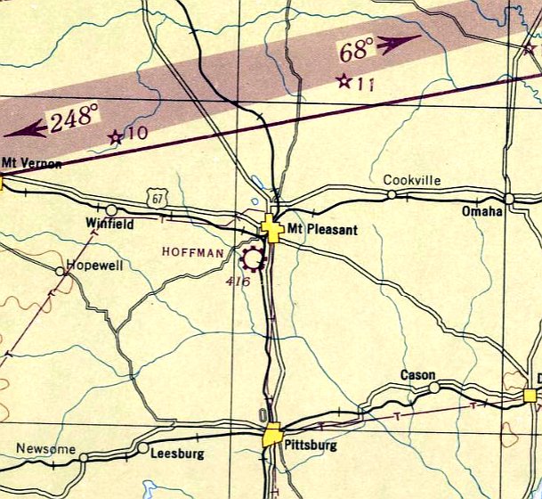
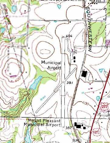
Hoffman Airport / (Original) Mount Pleasant Municipal Airport, Mount Pleasant, TX
33.13, -94.98 (East of Dallas, TX)
Hoffman Airport, as depicted on the April 1947 Shreveport Sectional Chart.
Hoffman Airport was evidently established at some point between 1946-47,
as it was not yet depicted on the September 1946 Shreveport Sectional Chart.
The earliest depiction which has been located of Hoffman Airport was on the April 1947 Shreveport Sectional Chart,
which depicted Hoffman as a commercial/municipal airport.
It was still labeled Hoffman Airport on the 1949 Shreveport Sectional Chart.
Hoffman Airport was apparently renamed Mount Pleasant Municipal Airport at some point between 1949-62,
as that is how it was listed in the 1962 AOPA Airport Directory.
It was described as having 2 asphalt runways (4,000' 17/35 & 3,000' 3/21), and the operator was listed as the William Phinney Flying Service.
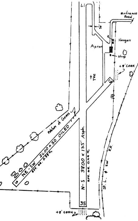
The 1963 TX Airport Directory (courtesy of Steve Cruse) depicted Mount Pleasant Municipal Airport with significantly shorter runway lengths:
a 3,800' asphalt Runway 17/35 & a 2,600' oiled Runway 3/21.
An apron sat on the northeast corner of the field, with several small hangars.
The manager was listed as William Pinney, of the William Phinney Flying Service.

The earliest photo which has been located of Mount Pleasant Municipal Airport was a 2/11/64 USGS aerial view.
It depicted the field as having 2 asphalt runways, with 4 small hangars on the northeast side, but strangely no aircraft were visible on the field.
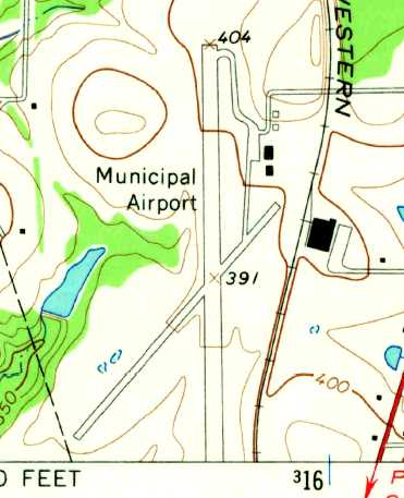
The 1965 USGS topo map depicted Mount Pleasant Municipal Airport as having 2 paved runways, with 4 small hangars on the northeast side.
The airfield configuration was unchanged in the 1967 TX Airport Directory (courtesy of Brad Stanford),
but the manager was listed as Harrold Huneycutt.
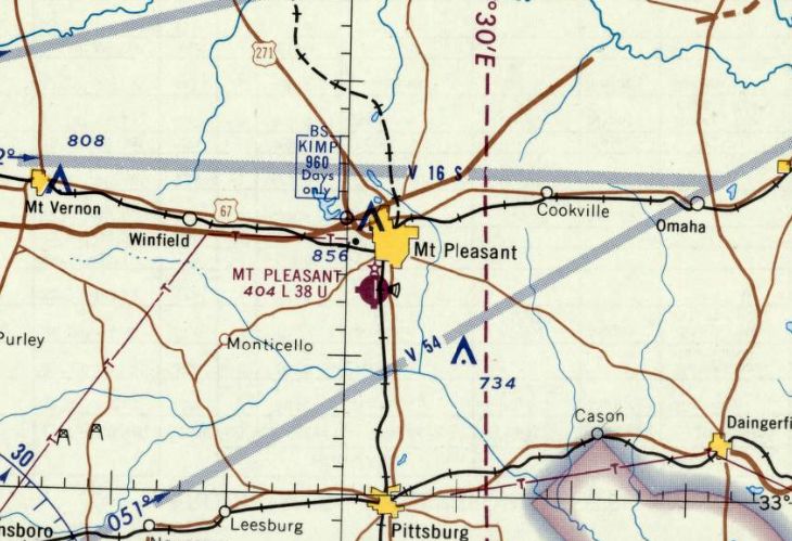
The last aeronautical chart depiction which has been located of the original Mt. Pleasant Airport was on the June 1968 Shreveport Sectional Chart,
which depicted it as having a single paved 3,800' north/south runway.
The 1980 USGS topo map depicted the Mt Pleasant Municipal Airport as having 2 paved runways,
with a ramp with several hangars on the northeast side of the field.
The airfield configuration was unchanged in the 1985 TX Airport Directory (courtesy of Steve Cruse), but the manager was listed as J.D. Roper.
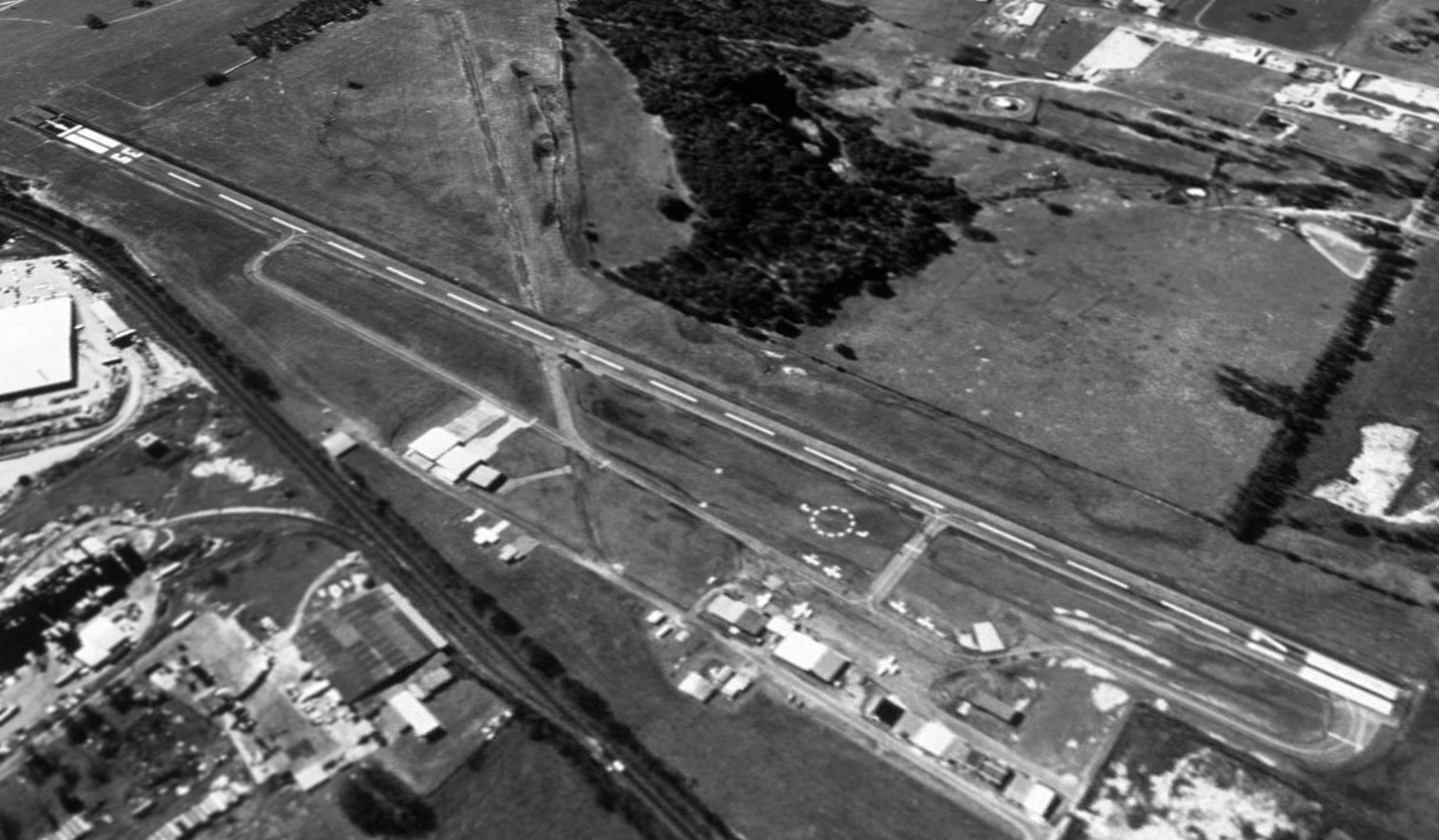
A 1995 USGS aerial view looking at Mt Pleasant Airport while it was still open.
The original Mount Pleasant Airport was closed in 2003 when it was replaced by a newly-built Mount Pleasant Municipal Airport to the east.
According to Mark Bergee, "I called over to the Mount Pleasant City Manager
and he told me that the old airport was sold to a private party for commercial development.
Unfortunately… there was a stipulation in the sale that disallows any aviation activity at the old airfield."
A circa 2006 aerial view looking east at the hangars which remain standing at the site of the original Mt Pleasant Municipal Airport.
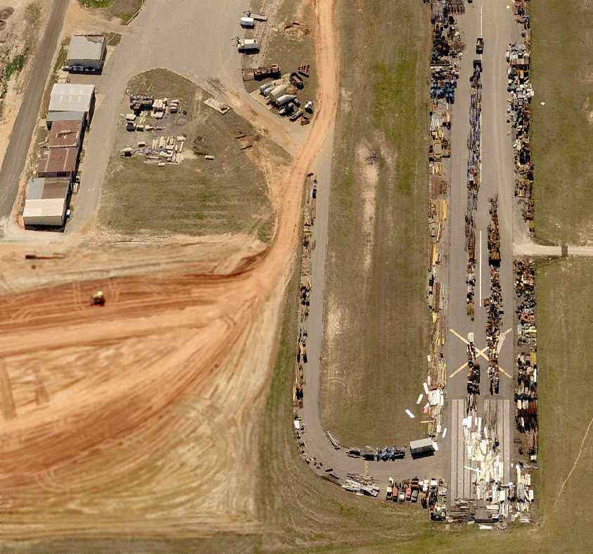
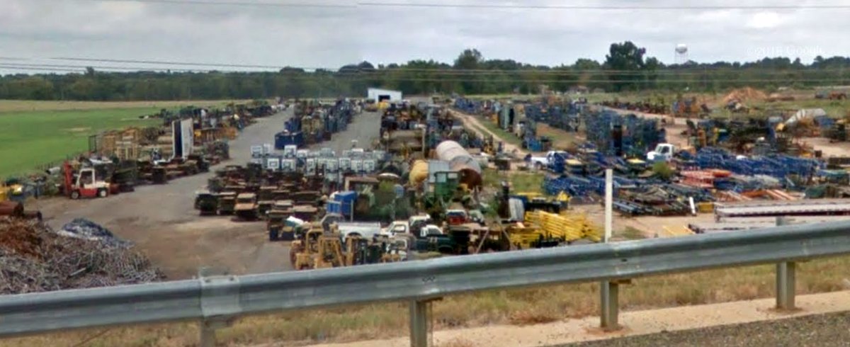
A circa 2006 aerial view looking south at the former runway & hangars at the site of the original Mt Pleasant Municipal Airport,
now used for storage of a large number of vehicles & other unidentified items.
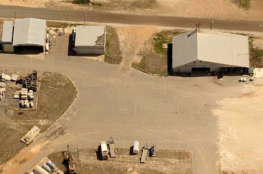
An October 2016 photo looking north at the remaining northern portion of runway at the site of the original Mt Pleasant Municipal Airport, reused for vehicle storage.
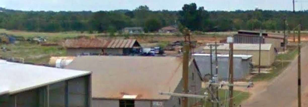
An October 2016 photo looking northwest at former hangars at the site of the original Mt Pleasant Municipal Airport.
The site of the original Mount Pleasant Municipal Airport is located west of the intersection of Route 271 & Airport Road, appropriately enough.
___________________________________________________
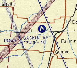
Perrin Auxiliary Army Airfield #2 / Gaskin Field / Gaskin Air Force Auxiliary Field, Sherman, TX
33.51, -96.76 (North of Dallas, TX)
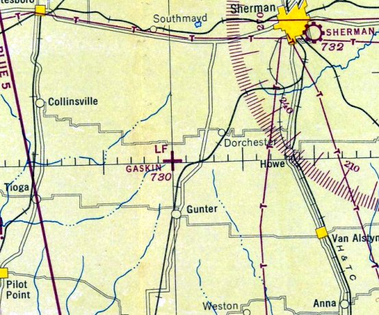
Gaskin Field, as depicted on the March 1944 Dallas Sectional Chart.
Photo of the airfield while in use has not been located.
Gaskin Field was not yet depicted on the February 1943 Dallas Sectional Chart.
The earliest depiction which has been located of Gaskin Field was on the March 1944 Dallas Sectional Chart,
which depicted it as an auxiliary airfield.
This 594 acre field was built during WW2 as one of 5 satellite fields for Perrin AAF (16 miles northeast), which conducted basic flight training.
Gaskin Field was kept on inactive status after the end of WW2,
but was reportedly reactivated from 1948-1952 as Gaskin Air Force Auxiliary Field.
It was labeled “Gaskin AF Aux” on a 1954 Army Map Service topo map (courtesy of Bob Morris).
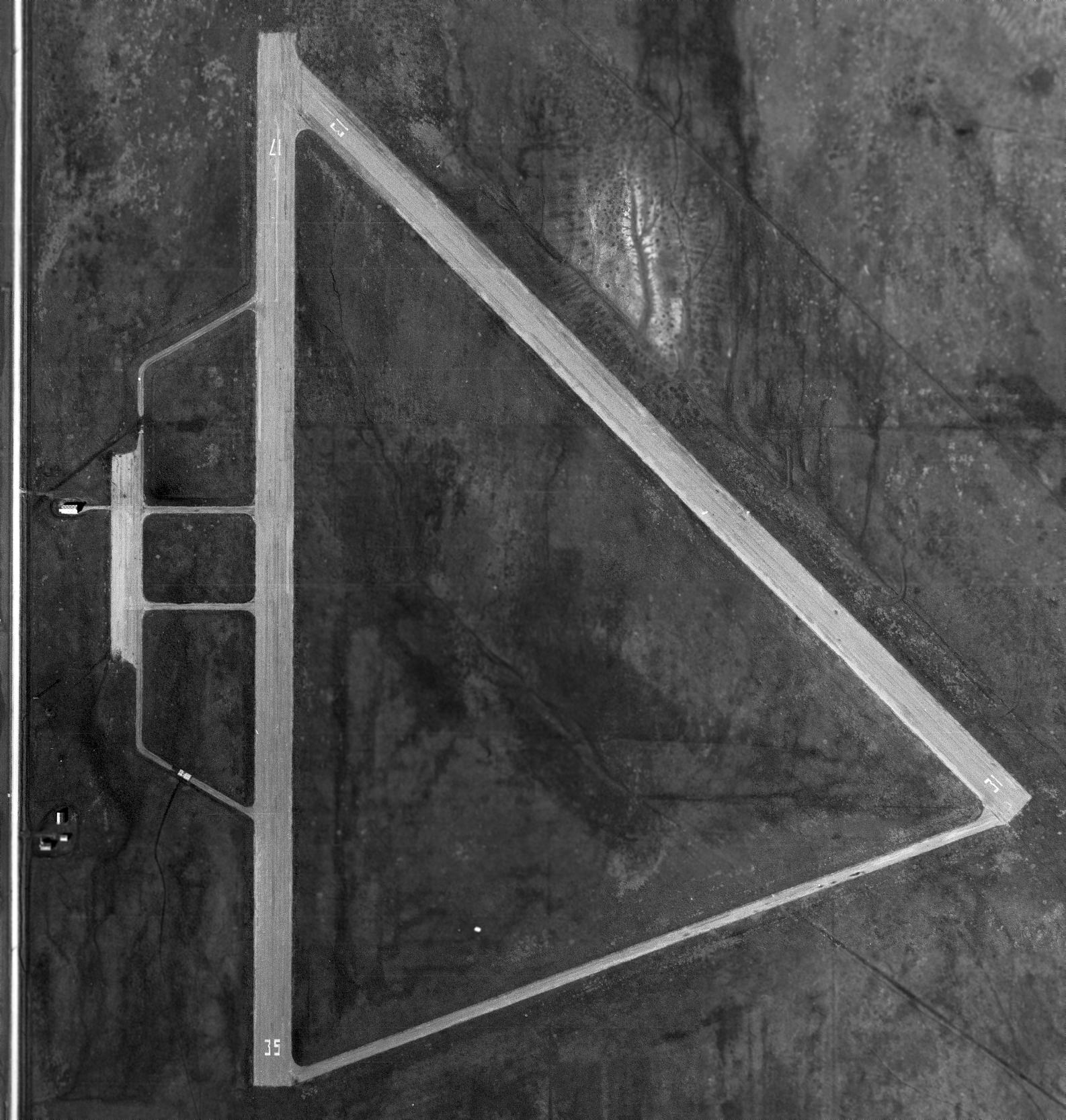
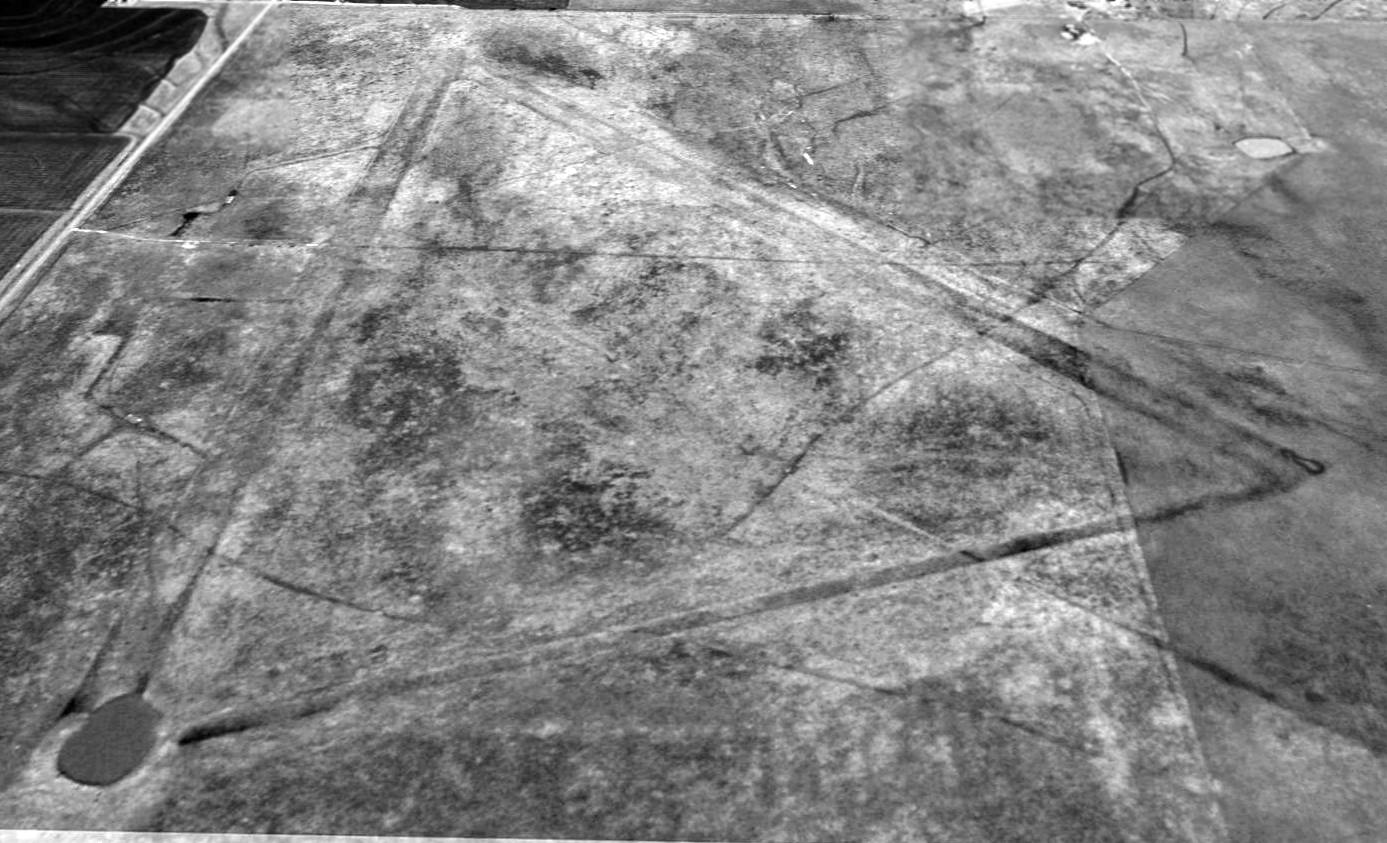
The earliest photo which has been located of Gaskin Field was a 2/23/55 USGS aerial view (courtesy of Bob Morris).
Both runways (17/35 & 13/31) were painted with runway numbers as active runways.
Bob Morris observed, “Gaskin had 2 runways: 17/35 (north/south) & 13/31 (northwest/southeast), and taxiway between the south end of Runway 17/35 & the southeast end of Runway 13/31.
There were 4 taxiways on the west of Runway 17/35 that led to a small parking apron, and an apparently administration / field operations building with a red & white checkered roof.
The shadow of the operations building appears to indicate it had an elevated structure, possibly a control tower, on its east end.
Immediately east of the north/south road to the west of the field, and southwest of the south end of the parking apron,
can be seen the rotating beacon & its shadow (which is actually more conspicuous than the tower) extending to the northeast.
Due south of the rotating beacon is a cluster of 3 buildings which also appear to have the standard red & white checkered roofs.
Whether these buildings were involved with the operation of the field, or whether their roofs were painted merely for visibility/safety/identification, is not known.
I am of the opinion that the runways, taxiways & apron were not paved with concrete or asphalt. This is based on the fact that they are of a light color on the aerial photo.
The only paved runways that appear light on aerial photos are concrete, and if they were made of concrete they would be readily visible, even today.
The north/south road immediately west of the field is shown on the 1940 Grayson County Highway Map as a gravel surfaced road.
That coupled with the fact that the runways appear almost as light as the highway & that the field is almost totally obliterated today,
leads me to believe the runways, taxiways & parking apron were probably made of packed gravel with possibly an oiled surface to control dust.”
Strangely, "Gaskin AF" was depicted as an active airfield on 1957 Dallas Sectional Chart (courtesy of Chris Kennedy),
but it was not listed among active airfields on the chart's Aerodromes table, so it is not clear if it was indeed still open in 1957.
The chart described the field as having 2 paved runways, with the longest being 4,000'.
Gaskin Field was no longer depicted at all on the 1958 USGS topo map.
Gaskin Field was definitely abandoned by 1960, as it was not depicted at all (even as an abandoned airfield) on the 1960 Dallas Sectional Chart.
The remains of Gaskin Field were not depicted at all on recent USGS topo maps.
A 1995 USGS aerial view looking north showed the Gaskin Field pavement had been broken up & the land returned to farming,
but the outlines of the 2 runways were still clearly recognizable, along with a connecting taxiway at the south end.
The outline of a ramp area to the west of the runways was also perceptible.
Ross Richardson said in 2003, "I came across Gaskin quite by accident.
I was flying from Sherman to Denton & flew over this pasture that sure looked like the photo you provide in your website.
I talked to some long-time pilots in the area & they confirmed that it was a AAF field.
I wonder if it could be refurbished into a residential airpark. Hmmmm."
Bo Boggs reported in 2003, "I have been observing it for 4 years & each year it becomes less distinct."
Southwest Airlines pilot Will Ware reported that Gaskin Field was still recognizable from the air as of 2007.
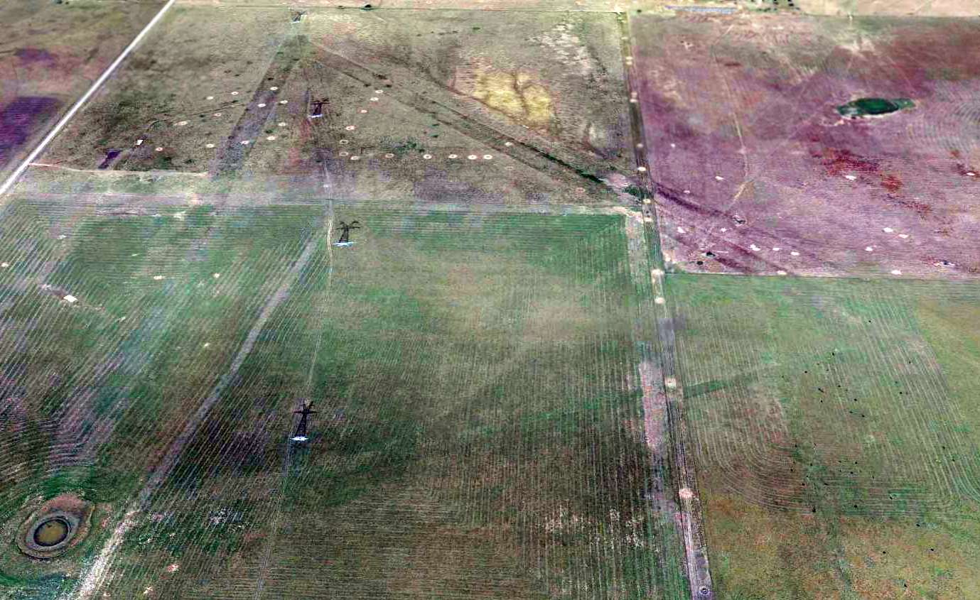
A 2014 aerial view looking north at the remains of Gaskin Field, showing the outline still barely recognizable of the 2 runways & the connecting taxiway.
See also: http://www.airforcebase.net/usaf/perrin.html
____________________________________________________
Or if you prefer to contact me directly concerning a contribution (for a mailing address to send a check),
please contact me at: paulandterryfreeman@gmail.com
If you enjoy this web site, please support it with a financial contribution.
____________________________________________________
This site covers airfields in all 50 states.