Abandoned & Little-Known Airfields:
Texas: Western San Antonio area
© 2002, © 2025 by Paul Freeman. Revised 10/24/25.
This site covers airfields in all 50 states: Click here for the site's main menu.
____________________________________________________
Please consider a financial contribution to support the continued growth & operation of this site.
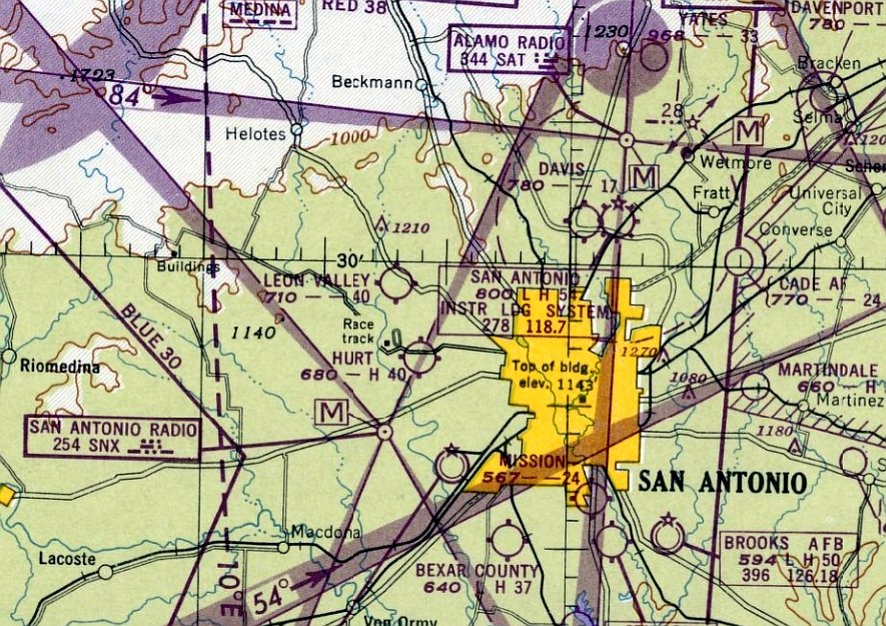
Art Stewart Airport / Standard Industries Airfield (revised 10/24/25) - Bandera Airport / Flying L Ranch (revised 4/13/24) - Bexar County Airport (revised 2/15/22)
Culver Field / Leon Valley Airport (revised 2/15/22) - Hurt Field (revised 4/13/24) - Kelly Field #1 / Duncan Field (revised 8/29/20)
Lake Airport / Lakefield Airport / Horizon Airport (revised 4/13/24) - (Original) Louis Schreiner Field (added 10/1/22)
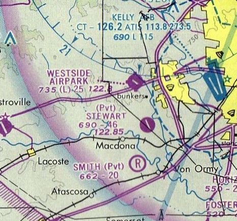
Pfeffer Ranch Airfield / Purple Sage Ranch Airfield (revised 9/21/19) - Westside Executive Airport / Westside Airpark (revised 10/24/25)
____________________________________________________
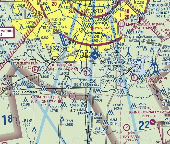
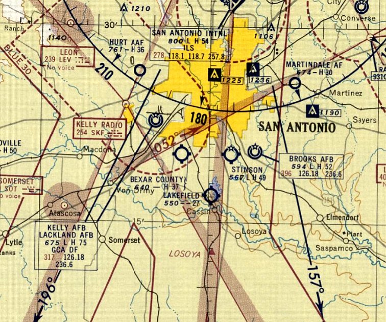
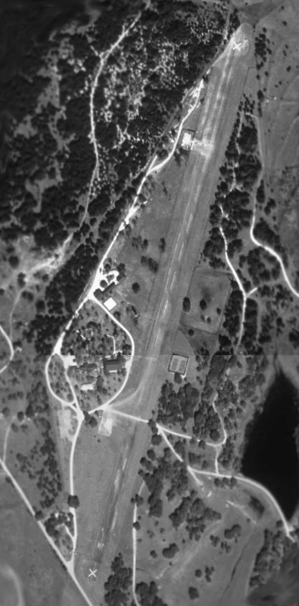
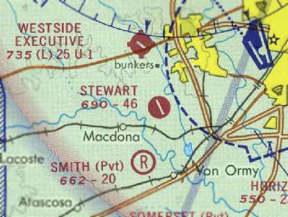
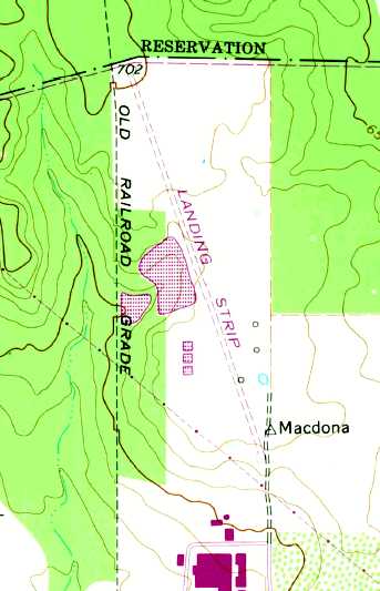
Lake Airport / Lakefield Airport / Horizon Airport (74R), San Antonio, TX
29.285, -98.498 (Southwest of Downtown San Antonio, TX)
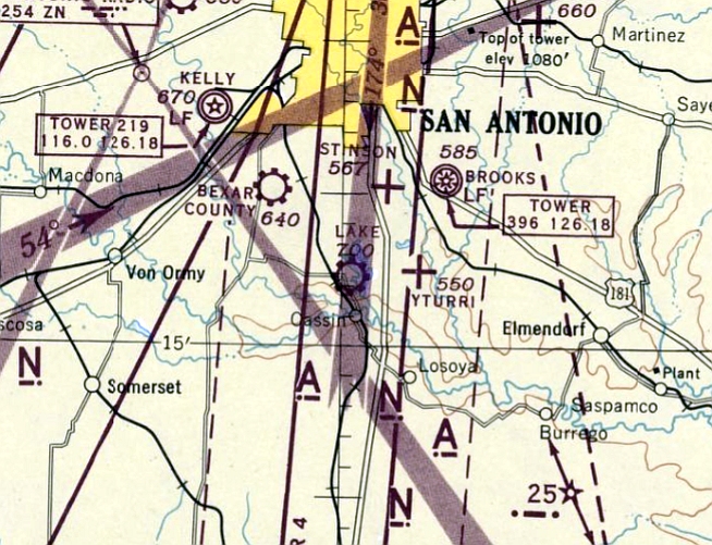
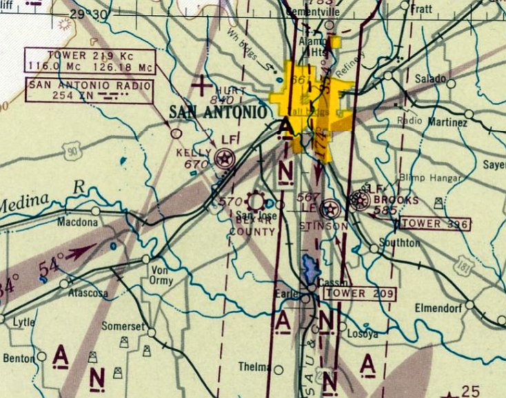
Lake Airport, as depicted on the July 1945 San Antonio Sectional Chart.
Lake Airport was not yet depicted on the January 1945 San Antonio Sectional Chart.
According to its FAA Airport/Facility Directory data, this airport was activated in April 1945.
The earliest depiction which has been located of Lake Airport was on the July 1945 San Antonio Sectional Chart.
It depicted Lake Airport as a commercial/municipal airport.
The earliest photo which has been located of Lake Airport was a 1955 aerial view.
It depicted Lake Airport as having 2 runways & 3 small buildings along the west side,
along with 2 light single-engine planes, one of which was in-flight over the northwest/southeast runway.
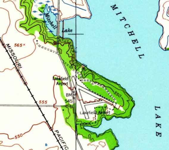
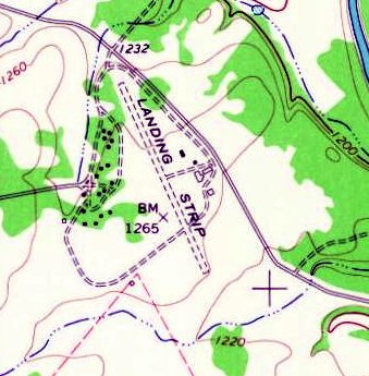
Lake Airport was evidently renamed Lakefield Airport at some point between 1945-53, as that is how it was labeled on the 1953 USGS topo map.
It depicted Lakefield Airport as having 2 runways & 2 small buildings along the west side.
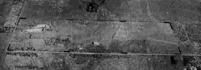
The earliest photo which is available of Lakefield Airport was a 2/5/63 USGS aerial view.
It depicted Lakefield as having 2 runways & several buildings on the west side, but there were no aircraft visible on the field.
Lakefield Airport was evidently renamed Horizon Airport at some point between 1953-67, as that is how it was labeled on the 1967 USGS topo map.
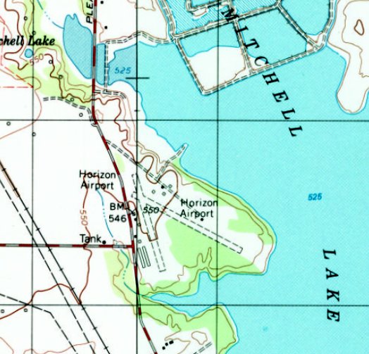
The 1992 USGS topo map depicted Horizon Airport as having 2 runways & several hangars along the west side.
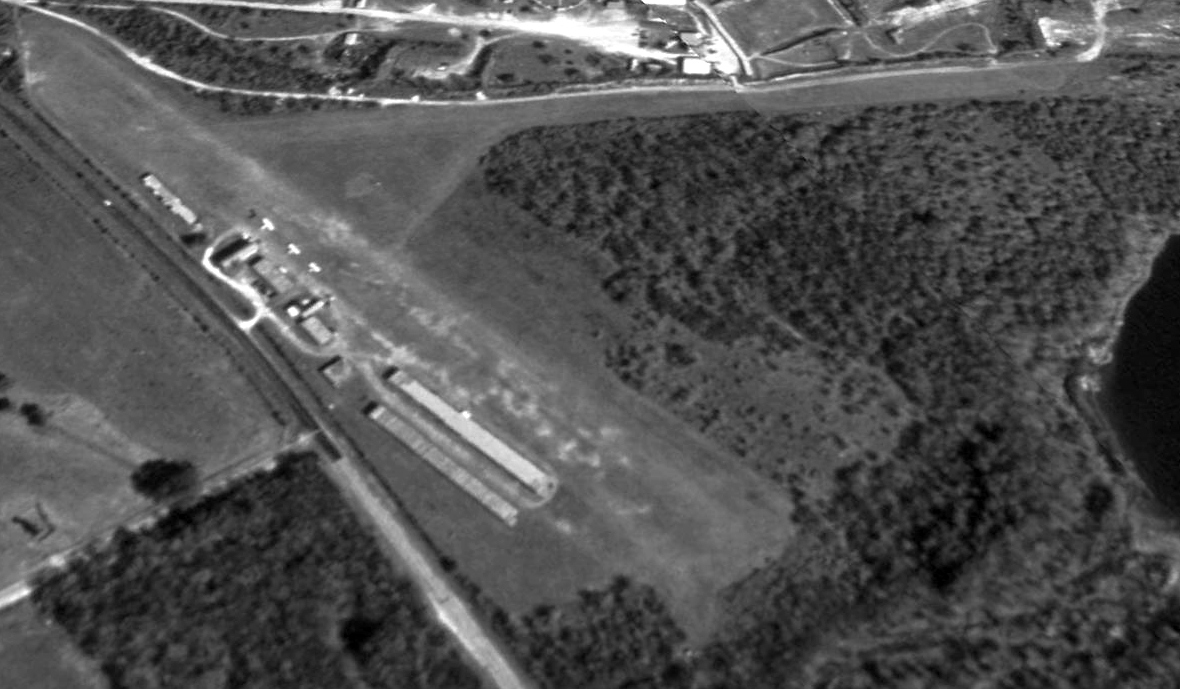
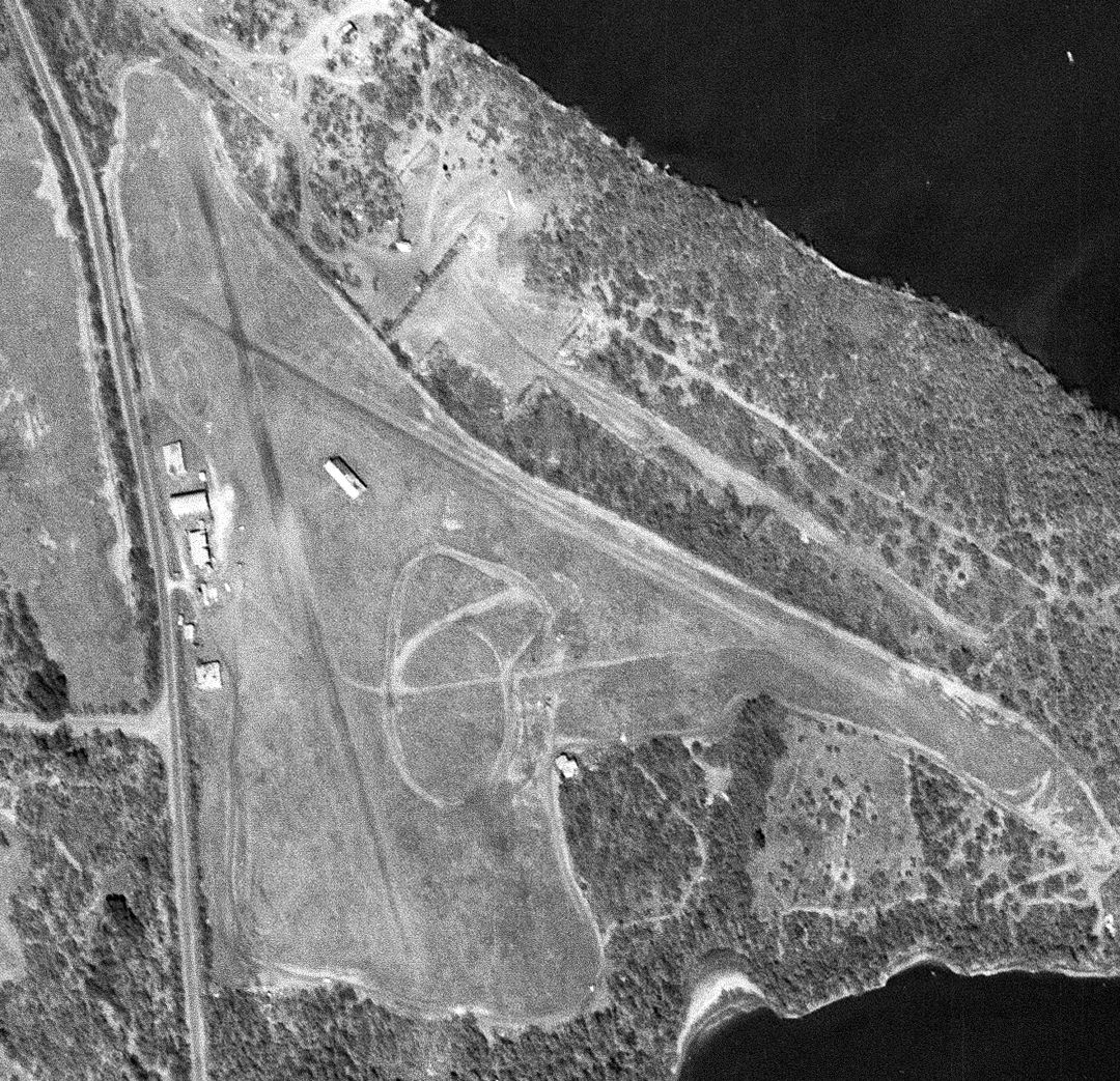
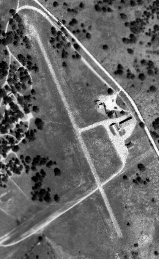
The earliest photo which is available of Horizon Airport was a 1993 USGS aerial view looking northeast.
It depicted the airfield in the same configuration as previous photos, and 3 light single-engine planes were parked on the west side.
The last photo which has been located showing a plane at Horizon Airport was a 2016 aerial view looking northeast.
One light single-engine plane were parked in front of a hangar.
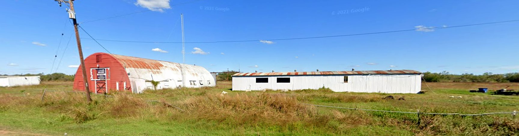
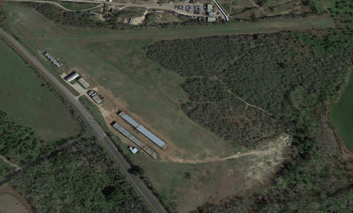
A 2021 photo looking northeast at the Horizon Airport hangars.
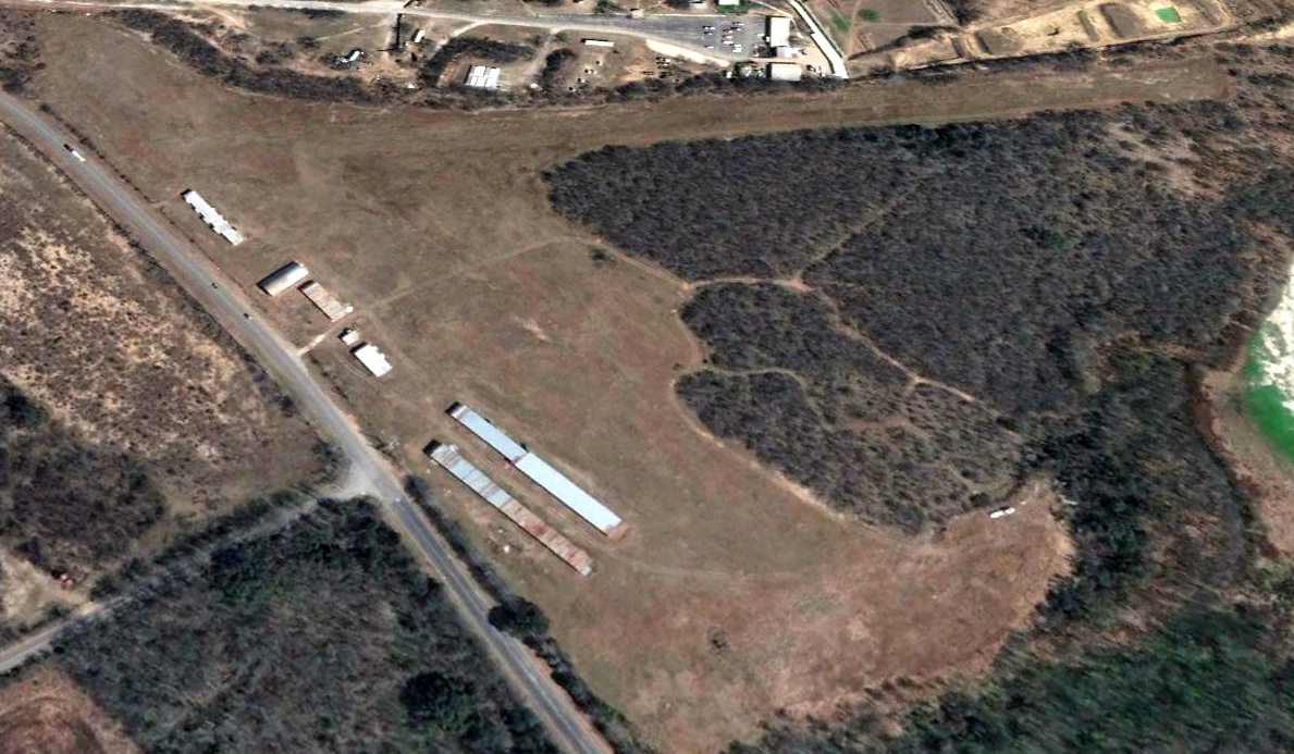
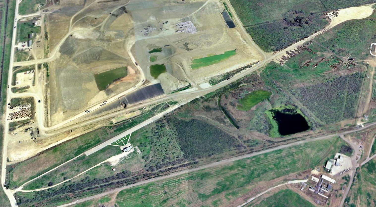
A 2022 aerial view looking northeast depicted Horizon Airport as remaining intact, but devoid of aircraft.
The 2022 San Antonio Sectional Chart depicted Horizon Airport as having a 2,300' unpaved runway.
James Taylor reported of Horizon Airport in 2022, it was “definitely in the path of progress.
It was one of my favorite airports for doing tailwheel demos.”
Unfortunately the end came for Horizon Airport on 7/30/22, when a NOTAM listed the airport as closed (for reasons unknown).
Thanks to James Taylor for pointing out this airfield.
__________________________________________________
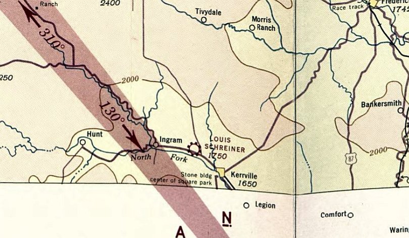
(Original) Louis Schreiner Field, Kerrville, TX
30.075, -99.2 (West of Downtown San Antonio, TX)
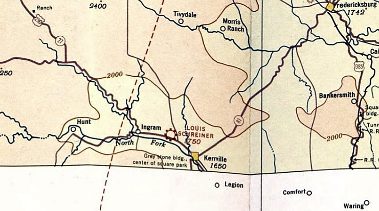
Louis Schreiner Field, as depicted on the 1934 San Antonio Sectional Chart.
The original location of Kerrville's Louis Schneider Field was northwest of Kerrville.
As reported in “The Case of the Missing Airport” by Joe Herring in the 6/3/22 Daily Times,
“In the summer of 2000, Bob Sieker, who for many years operated a flying service at the site of today’s [Scheider] airport, sat for an interview.”
He recalled, ““The (first) airport was established between Ingram & Kerrville.
Mr. [Louis] Schreiner gave them that land & that was midway between here & Ingram.”
Sieker learned to fly at the old airstrip. It was basically a field: no runways; no hangars.
The earliest depiction which has been located of Louis Schreiner Field was on the 1934 San Antonio Sectional Chart.
It depicted Louis Schreiner Field as a commercial/municipal airport.
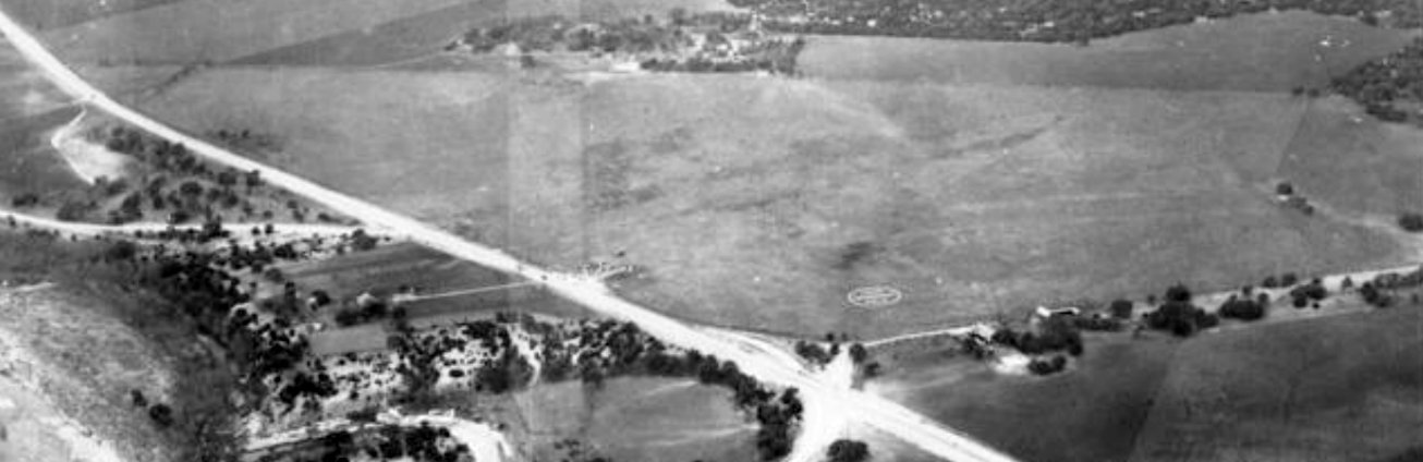
The only photo which has been located of the original Louis Schreiner Field was a 1/24/34 US Army aerial view looking northwest.
It depicted Louis Schreiner Field as an irregularly-shaped grass field with an airport circle marking on the southeast corner,
and possibly some small buildings or planes along the southern edge.
The last depiction which has been located of Louis Schreiner Field was on the June 1942 San Antonio Sectional Chart.
It depicted Louis Schreiner Field as a commercial/municipal airport.
According to Bob Sieker, the first airport [the original Louis Schreiner Field] was sold during [WW2];
they “took the money & bought Goss’s farm east of Kerrville & renamed it Louis Schreiner Field, and they did away with the old Schreiner Field.”
The original Louis Schreiner Field was no longer depicted on the 1944 San Antonio Sectional Chart,
which instead depicted the new Schreiner Field to the southeast of Kerrville.
A 1955 aerial view showed several buildings had been built on the southeast portion of the original Louis Schreiner Field property,
but no trace of the airport remained.
A 2022 aerial view showed no trace remaining of the original Louis Schreiner Field.
Thanks to Ronald Deutch for pointing out this airfield.
__________________________________________________
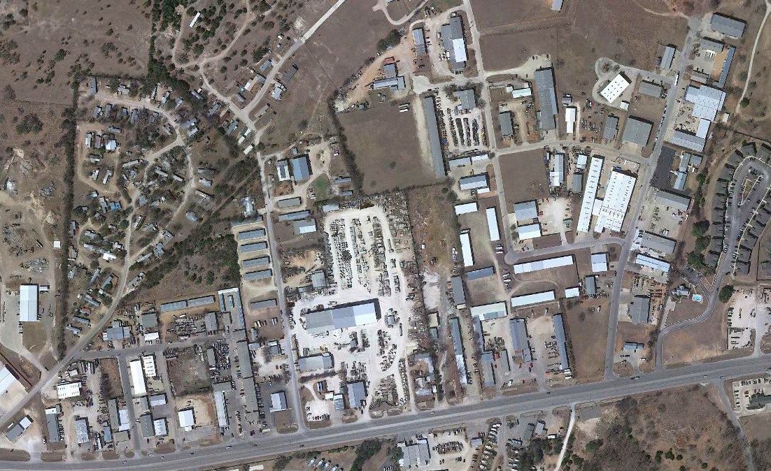
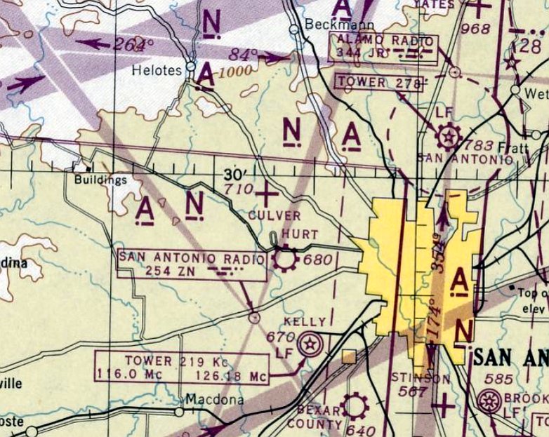
Culver Field / Leon Valley Airport, San Antonio, TX
29.49, -98.62 (West of Downtown San Antonio, TX)
Culver Field, as depicted on the July 1944 San Antonio Sectional Chart.
Culver Field was evidently established at some point in 1944,
as it was not yet depicted on San Antonio Sectional Charts from 1938/40/42 through January 1944.
The earliest depiction which has been located of Culver Field was on the July 1944 San Antonio Sectional Chart,
which depicted Culver as an auxiliary airfield.
According to property owner Henry Daughtry, “Culver Field was a grass air strip operated in WW2.”
Culver Field was still depicted on the July 1945 San Antonio Sectional Chart (courtesy of Chris Kennedy).
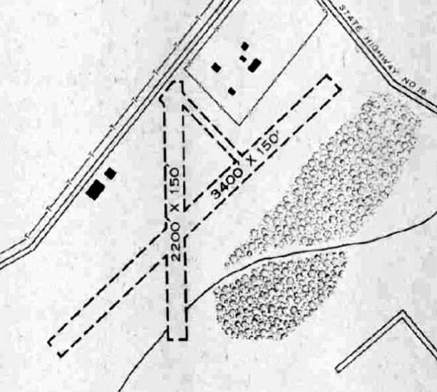
The 1945 AAF Airfield Directory (courtesy of Scott Murdock) described Culver Field as a 120 acre irregularly-shaped property
having 2 sod runways, measuring 3,400' northeast/southwest & 2,200' north/south.
A single 140' x 120' stone & metal hangar was depicted along with a smaller building on the west side.
Culver was said to be owned & operated by private interests.
Culver Field was evidently renamed Leon Valley Airport at some point between 1945-46,
as that is how it was labeled on the January 1946 San Antonio Sectional Chart.
The last aeronautical chart depiction which has been located of Leon Valley Airport was on the January 1949 San Antonio Sectional Chart.
It depicted Leon Valley Airport as having a 4,000' unpaved runway.
Leon Valley Airport was evidently closed (for reasons unknown) at some point in 1949,
as it was no longer depicted on the August 1949 San Antonio Sectional Chart.
The 1953 USGS topo map no longer depicted Leon Valley Airport, but still depicted the former hangar.
A 1955 USGS aerial photo showed that houses had been built over the Leon Valley Airport site,
but the former hangar remained standing on the west side.
A circa 2010 aerial view looking north at the former hangar which remains at the Leon Valley Airport site.
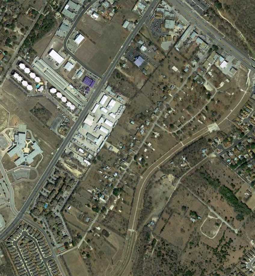
A 2/7/14 aerial view showed houses covering the Leon Valley Airport site, but the former hangar remained standing on the west side.
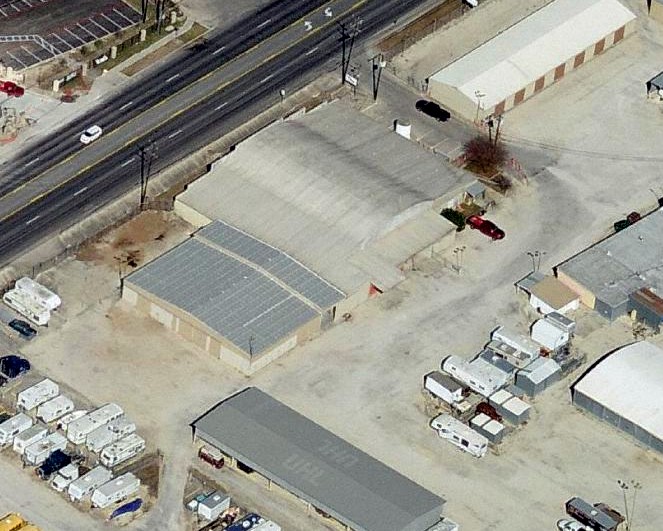
Henry Daughtry reported in 2014, “The original hangar, circa 1945, is still on our property at 6200 Grissom Road, now operating as Leon Valley Storage.”
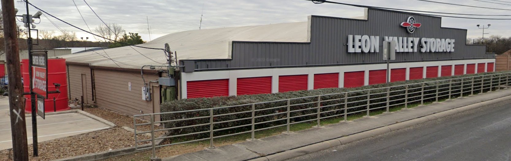
A January 2022 photo looking southeast at the circa 1945 Culver Field / Leon Valley Airport hangar, with the arched-roof still recognizable behind a Leon Valley Storage facade.
Thanks to Henry Daughtry for pointing out this airfield.
__________________________________________________
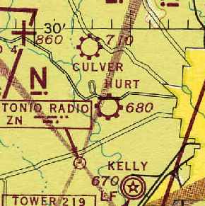
Hurt Field / Hurt Army Airfield, San Antonio, TX
29.44, -98.6 (West of Downtown San Antonio, TX)
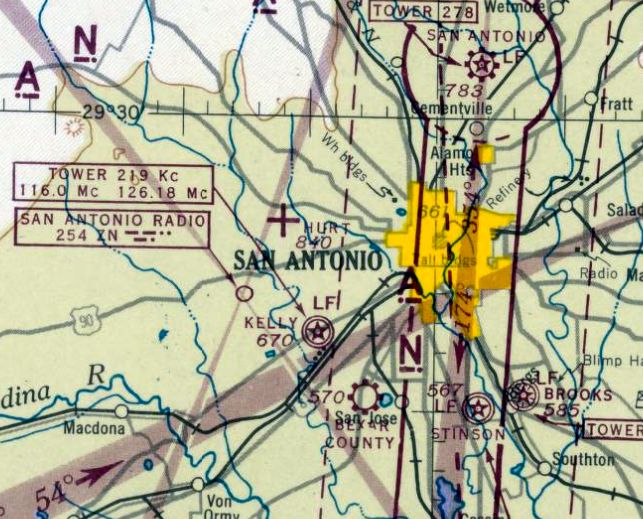
Hurt Field, as depicted on the January 1944 San Antonio Sectional Chart.
The date of construction of Hurt Field has not been determined.
According to David Brooks, it "opened sometime during the 1930s."
However, Hurt Field was yet depicted on the 1934/38/42 San Antonio Sectional Charts,
or listed in The Airport Directory Company's 1937 Airports Directory (courtesy of Bob Rambo).
A 1938 aerial photo of the site of Hurt Field (according to Steve Frost) did not depict an airfield, just open farm fields.
The earliest depiction which has been located of Hurt Field was on the January 1944 San Antonio Sectional Chart.
It depicted "Hurt" as an auxiliary airfield.
The April 1944 US Army/Navy Directory of Airfields (courtesy of Ken Mercer) listed San Antonio "Hurt", but said "no data available."
Tammy Frost reported, "I just got in touch with the air museum at Lackland AFB
and learned that Hurt Field was a private airstrip used by Lackland during WW2 for 'touch & go' exercises,
and the field reverted back to private use after the war.
They told us that there is no military record of the field because it was only annexed briefly."
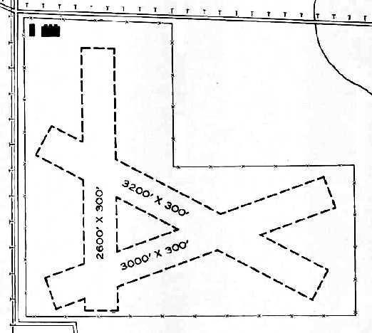
The 1945 AAF Airfield Directory (courtesy of Scott Murdock) described Hurt Airport as a 168 acre L-shaped property
containing 3 sod runways, the longest being the 3,200' WSW/ESE strip.
Two buildings were depicted on the northwest side, one of which was a 100' x 60' metal hangar.
Hurt was said to be owned & operated by private interests.
The entrance to Hurt Field was at the intersection of Culebra Road & Callaghan Road (according to David Brooks).
Robert Bogard recalled, “From early 1945 to 1950 I flew out of Hurt Field,
renting the Piper Cubs they had there until I bought a Cessna 140 in early 1949.
There was almost always something wrong with the Piper Cubs, e.g., a magneto didn't work, one wing was heavier than the other, the motor would die, etc.
Once I remember seeing the manager of the place flying one of the Cubs while a mechanic who worked there was standing on the landing gear & tinkering with the engine - in flight!
They had the franchise for Navions there, and the manager was always trying to sell me one.
He did manage to sell one to a neighbor of mine, but I was happy with my Cessna.
They had individual hangars lined up along one of the streets, and I eventually rented one for my Cessna.”
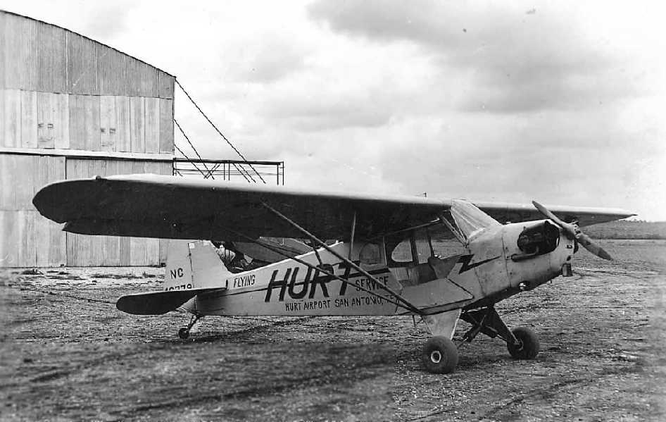
A circa 1940s photo of a Piper Cub marked of the “Hurt Flying Service, Hurt Airport” (courtesy of Jack Carson).
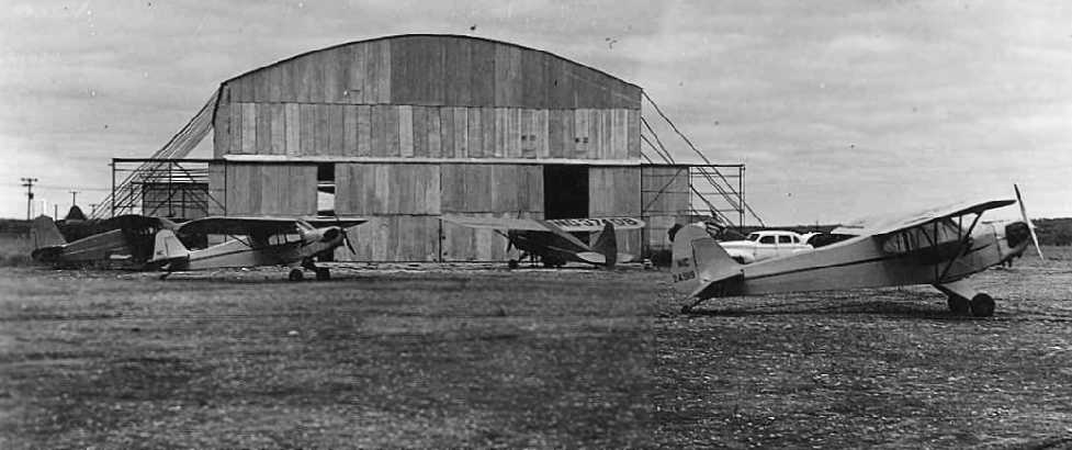
A circa 1940s photo of 5 aircraft parked in front of a Hurt Airport hangar (courtesy of Jack Carson).
The August 1949 San Antonio Sectional Chart depicted Hurt Field as having a 4,000' paved runway.
Dwight Andreas recalled, “My dad worked at Hurt Airport in the late 1940s into the mid-1950s.
He went to work for the Texas Air National Guard as a civilian employee as an aircraft mechanic shortly after WWII.
I remember as a young child going out there to work with him. It was way out in the country. What a treat that was.
I remember being in the hangar, which I believe was not fully enclosed, and I remember the smell of the lacquer the used to paint aircraft.
I can still smell it as well today as I could 50+ years ago.”
The Aerodromes table on the February 1950 San Antonio Sectional Chart (courtesy of David Brooks)
described Hurt Field as having 2 runways, with the longest being a 4,000' paved strip.
Gasoline & major maintenance were available, as it was designated as a commercial airfield.
The February 1952 San Antonio Sectional Chart depicted “Hurt (NG)” [National Guard] as having a 3,600' paved runway.
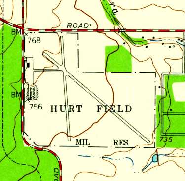
The 1953 USGS topo map depicted Hurt Field as having 2 runways, and a paved taxiway leading to a ramp on the west side, with several buildings & a large number of individual parking pads.
The property outline was also labeled as a Military Reservation.
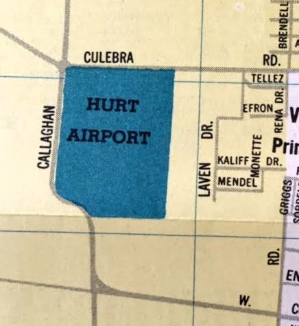
A 1954 street map (courtesy of Kevin Walsh) depicted Hurt Airport as a rectangular property outline.
The August 1954 San Antonio Sectional Chart depicted “Hurt AAF” as having a 3,600' paved runway.
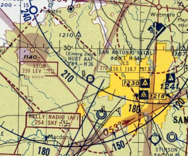
The last aeronautical chart depiction which has been located of Hurt Field was on the August 1955 San Antonio Sectional Chart.
Ir depicted “Hurt AAF” as “Emergency only”, with a 3,600' paved runway.
Hurt Field was apparently closed at some point between 1955-56,
as it was no longer depicted on the March 1956 San Antonio Sectional Chart.
Dwight Andreas recalled, “I believe it was 1957 that Hurt Airport was shut down due to air traffic conflicts with Kelly Field.
The TX ANG moved to Martindale Field where it is still in operation today.”
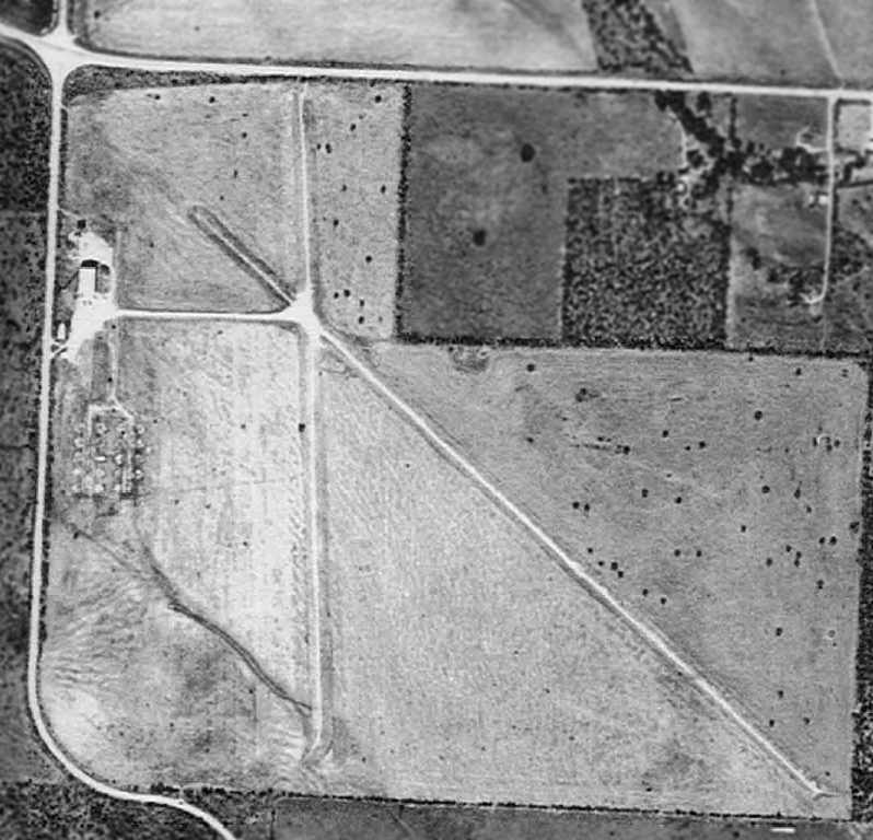
A 1959 Soil Conservation Service aerial photo (courtesy of Steve Frost)
depicted Hurt Field as having 2 paved runways, with a few small buildings on the west side of the field.
According to David Brooks, Hurt Field was "most likely discontinued sometime in the late 1950s
due to growth of San Antonio & the development immediately to the west of the Southwest Research Institute."
Another reason was probably Hurt Field's location only 3 miles away
directly along the extended centerline of the main runway of Kelly AFB.
No airfield was depicted at the site on a 1961 county road map (according to David Brooks).
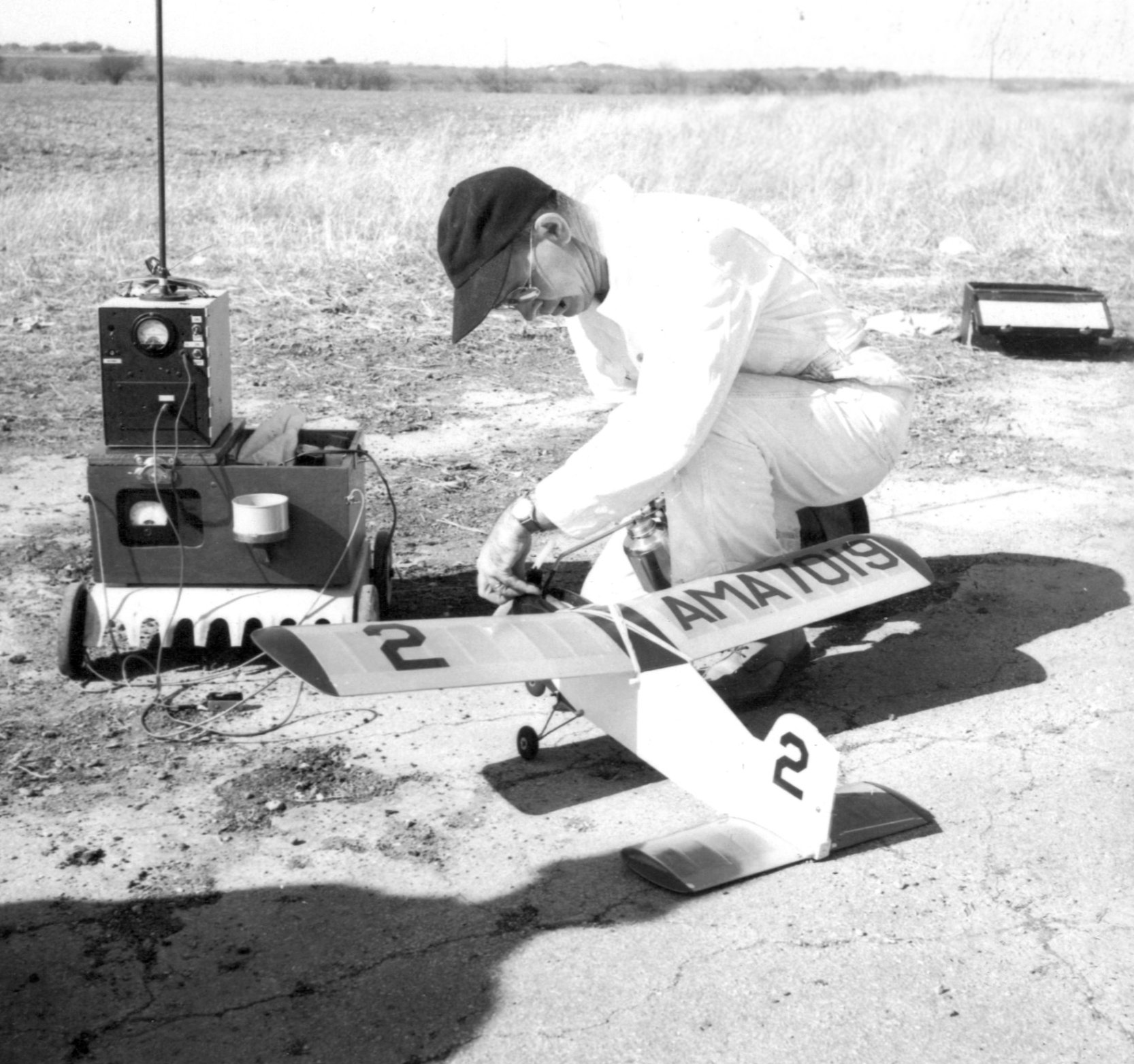
An April 1962 photo (courtesy of Jim Houston) of an unidentified man with with a radio-controlled model airplane at Hurt Field.
Jim Houston recalled, “My father & I were members of the Alamo Radio Control Society flying from Hurt Field in the early 1960s..
That was the first place I flew radio-controlled airplanes.”
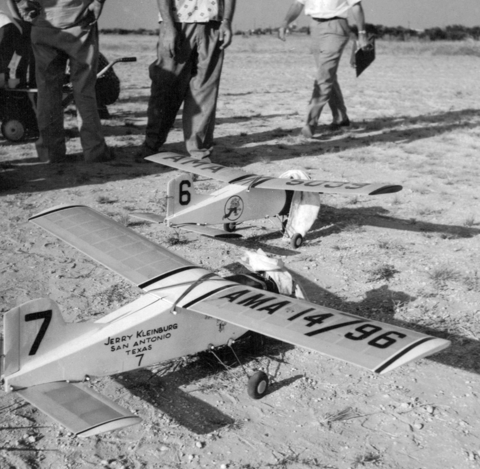
An October 1962 photo (courtesy of Jim Houston) of 2 radio-controlled model airplanes at Hurt Field.
Bruce Maurer recalled, “I am a native of San Antonio and as a child, teenager & adult was involved in radio-controlled model airplanes.
Our first club field was Hurt Airfield. We (Alamo Radio Control Society) leased the land from a farmer who owned [starting in] 1963.
All pavement had been grown over by 'Johnson grass' for the most part
and there was just one hangar building still standing, used for farm equipment & miscellaneous storage.
Our club scraped about 300' of the north/south runway & installed our own model airplane runway
roughly at the junction of the runways & taxiway in the same orientation.
The remnants of the north/south runway were barely visible towards the South.
About 50 yards east of our runway, the land was plowed & planted with spring/summer crops
as was the area where the northwest/southeast runway extended into.
I assume the farmer had removed & graded the remainder of that runway & planted that land also.
We were in the Kelly AFB flight path & had altitude restrictions due to that.
Several of the older members including my father had actually flown private aircraft in to the airport some time in the late 1940s &/or early 1950s
which is how they knew about the field & that it would serve model aircraft well.”
In a 1966 aerial photo (according to Steve Frost), Hurt Field appeared to be abandoned & grown-over.
According to Bruce Maurer, the Alamo Radio Control Society leased the Hurt Field property from the farmer who owned it until 1974,
“before the he finally sold the land due to the encroaching development.
The hangar building was not torn down until after we left.”
The 1993 USGS topo map depicted an "Army Reserve Training Center" on the western edge of the former Hurt Field.
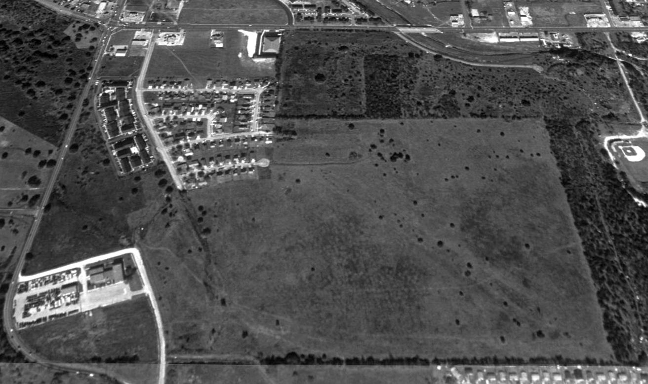
A 1995 USGS aerial view looking north at the site of Hurt Field showed the faint outline of at least one runway (oriented northwest/southeast) was still recognizable.
A 2002 aerial photo showed that the majority of the Hurt Field property had been covered by further development at some point between 1995-2002, erasing the last traces of the runway.
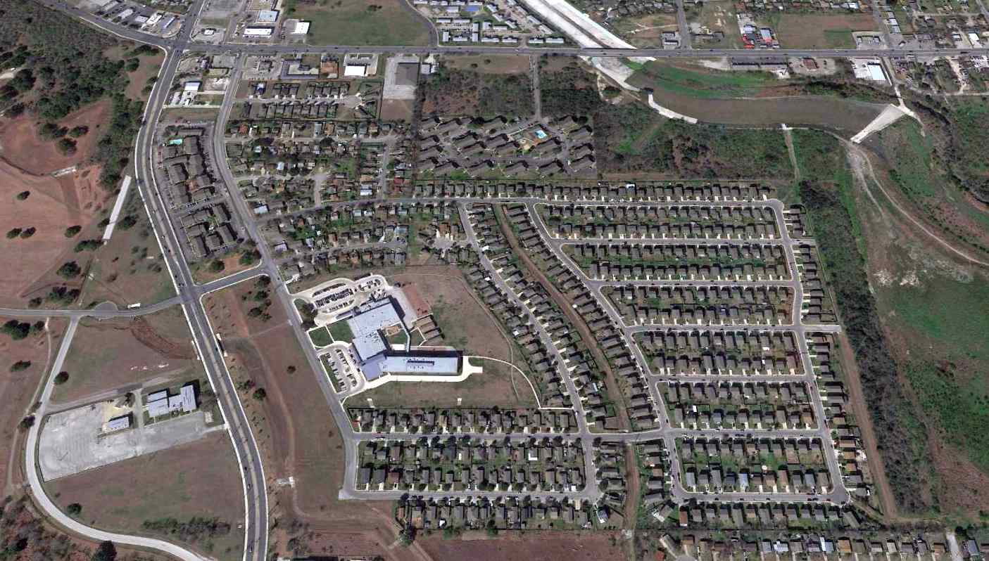
A 2016 aerial view looking north showed no trace remaining of Hurt Field.
The site of Hurt Field is located southeast of the intersection of Culebra Road & Callaghan Road.
__________________________________________________
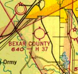
Bexar County Airport, San Antonio, TX
29.333, -98.544 (Southwest of Downtown San Antonio, TX)
Bexar County Airport, as depicted on the January 1944 San Antonio Sectional Chart.
Bexar County Airport was apparently established at some point between 1942-44,
as it was yet depicted on the September 1942 San Antonio Sectional Chart.
The earliest depiction which has been located of Bexar County Airport was on the January 1944 San Antonio Sectional Chart.
It depicted Bexar County Airport as a commercial/municipal airport.
The only photo which has been located showing Bexar County Airport while in operation
was a 10/25/43 aerial view looking north from the 1945 AAF Airfield Directory (courtesy of Scott Murdock).
It depicted Bexar County Airport as having a single east/west grass runway, with a few small buildings.
The April 1944 US Army/Navy Directory of Airfields (courtesy of Ken Mercer)
described "Bexar County (Wilcut)" Airport as having a 2,200' unpaved runway.
The 1945 San Antonio Sectional Chart (courtesy of Chris Kennedy) labeled the field as the "Bexar County" Airport.
The 1945 AAF Airfield Directory (courtesy of Scott Murdock) described “Bexar County Airport”
as a 154 acre rectangular property having a sod all-way landing field measuring 2,200' east/west.
The field was said to have a single 100' x 60' metal hangar, and to be owned & operated by private interests.
The Aerodromes table on the February 1950 San Antonio Sectional Chart (courtesy of David Brooks)
described Bexar County Airport as having 2 runways, with the longest being a 3,720' paved strip.
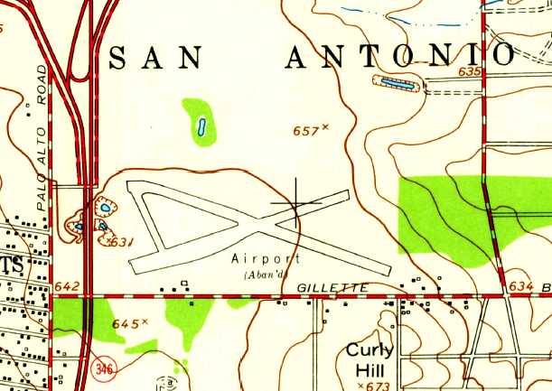
Bexar County Airport was evidently closed at some point between 1950-53,
as it was labeled “Airport (Aban'd)” on the 1953 USGS topo map.
It was depicted as having 2 paved runways, with a paved connecting taxiway,
and several small buildings on the southwest & southeast sides.

The last photo which has been located of the Bexar County Airport was a 4/23/53 USGS aerial view.
It depicted Bexar County Airport as having 2 runways in an “X” shape, and several small buildings on the southwest side.
A 1954 street map (courtesy of Kevin Walsh) depicted Bexar County Airport as a rectangular property outline.
The last aeronautical chart depiction which has been located of Bexar County Airport was on the February 1954 San Antonio Sectional Chart.
It depicted Bexar County Airport as having a 3,700' paved runway.
Bexar County Airport was no longer depicted on the August 1954 Edwards Plateau World Aeronautical Chart (courtesy of Chris Kennedy).
David Brooks observed that "Probably 2 events required it to be closed down.
First, expansion of the city & particular, the construction of Interstate 35, and the interchange with Loop 422.
The secondary reason is it lies on the direct flight path to the main runway at Kelley AFB.
It probably closed in the late 1950s or early 1960s. Interstate 35 was constructed during the period of 1960-65."
A 1995 USGS aerial photo showed no trace remaining of Bexar County Airport.

As seen in a 2017 aerial photo, not a trace remains of Bexar County Airport.
The site of Bexar County Airport is located south of the intersection of Interstate 35 & Route 16.
__________________________________________________
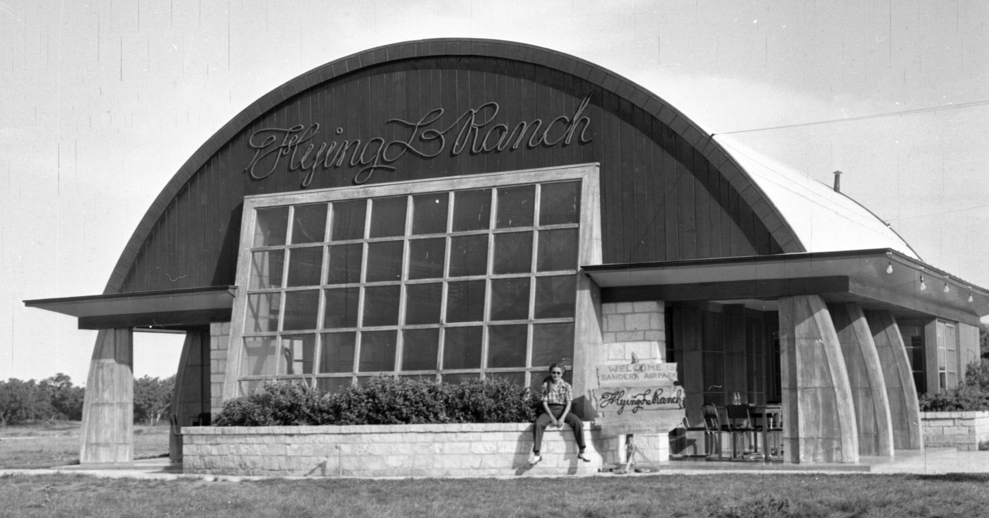
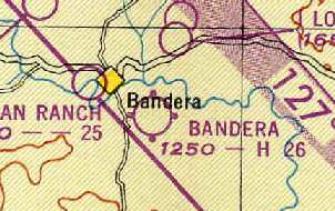
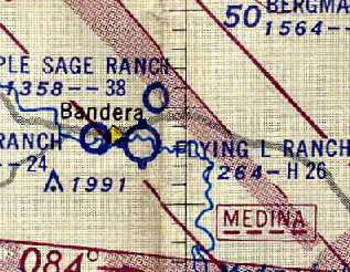
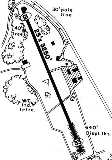
Bandera Airport / Flying L Ranch (T33), Bandera, TX
29.71, -99.046 (Northwest of San Antonio, TX)
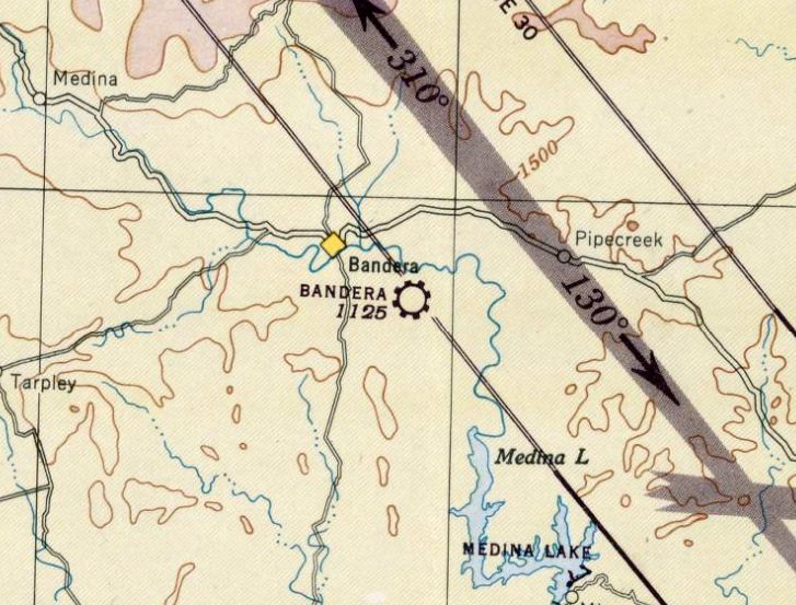
Bandera Airpark, as depicted on the July 1946 San Antonio Sectional Chart.
Bandera Airpark was not yet depicted on the January 1946 San Antonio Sectional Chart.
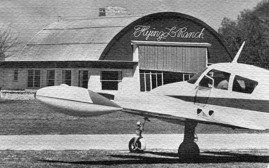
The 542-acre Flying L Ranch was purchased in 1946 by Jack Lapham, a retired Air Corps Colonel.
The Colonel built an airstrip & ran a flight school here.
As people began visiting the ranch, guest houses were built, and it eventually became a well-known stop for many celebrities.
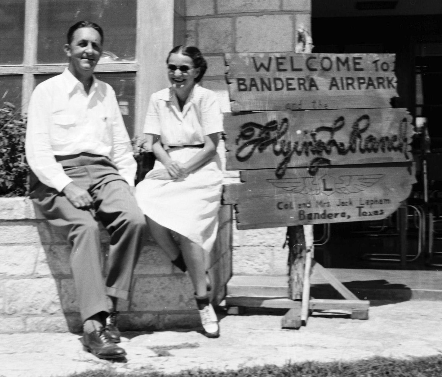
Lenny Koll recalled, “My Father & Mother (Leonard & Loretta Koll) established the Pilot’s Lounge on the property for Colonel Lapham.
They met the Colonel in San Antonio during his service days, my father being head chef at the Plaza Hotel there, a place that Jack Lapham often frequented.
Upon the end of his tour of duty, the Colonel established his dream in Bandera, taking my parents & me along to be part of establishing it.
I look at that as a very rich time in my life.”
Lenny continued, “He moved us (I was only 3 yrs old) to Bandera and, per agreement, they helped the Colonel get the ranch 'off the ground'.
I have memories from those days, especially taking hops daily with 'Uncle Jack' & many of the other aviation families that flocked to the Flying L.
His prized Beechcraft Bonanza was like a second home to me & I do recall sadly the tragic death of some of his family on the property,
but mostly I recall with fondness the years I spent there before the Colonel helped my parents establish their own restaurants in San Antonio.
Fun days indeed! Not many kids can say they were raised on a Dude Ranch, huh!”
The earliest aeronautical chart depiction which has been located of Bandera Airpark was on the July 1946 San Antonio Sectional Chart.
It depicted Bandera as a commercial/municipal airport.
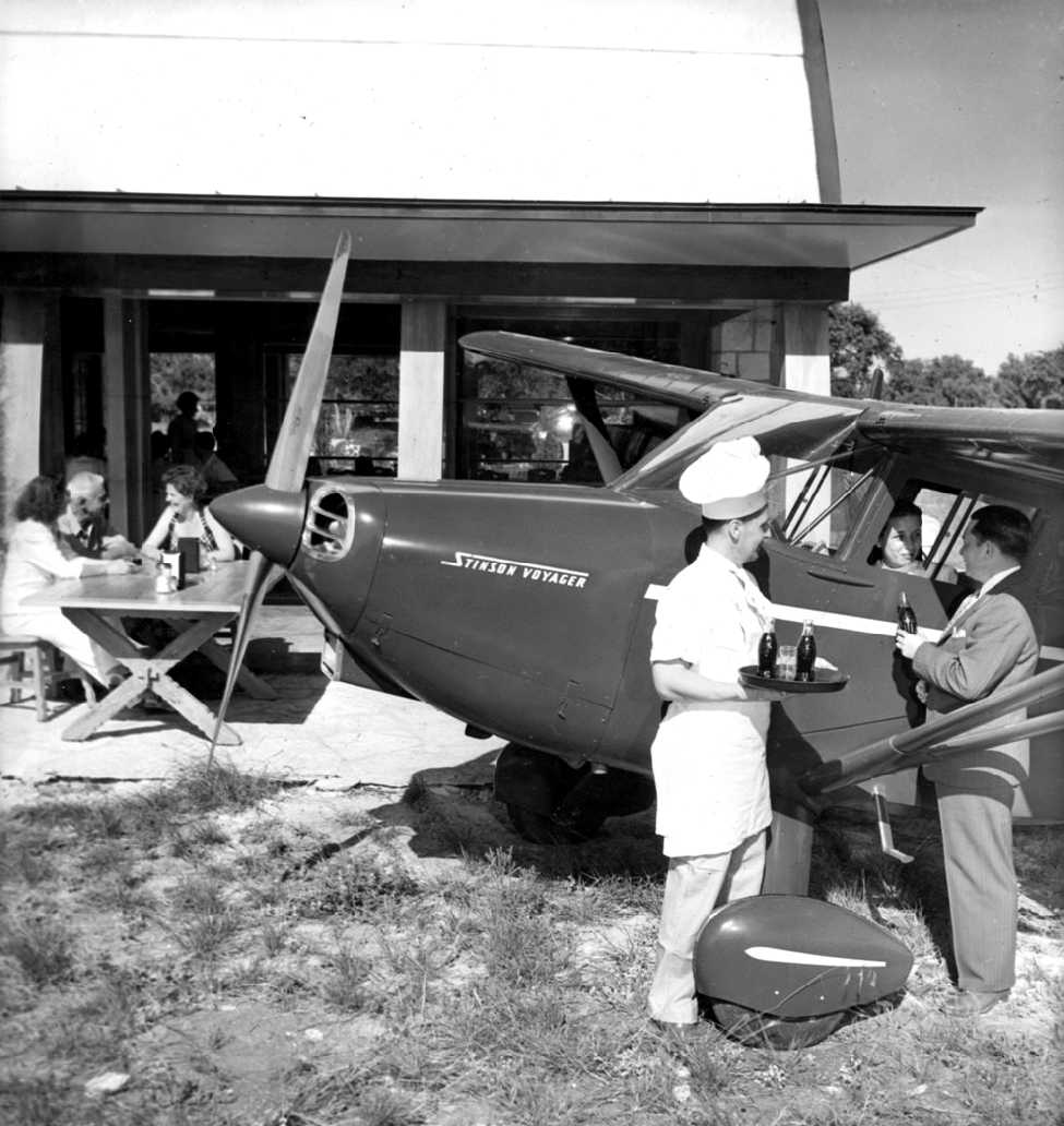
A June 1947 photo (courtesy of Lenny Koll Jr.) of his father (Lenny Koll Sr.) serving Cokes to a couple inside their Stinson Voyager in front of the Flying L clubhouse.
Lenny recalled that the pictures were “taken for publicity & used by both Coke & Stinson Aircraft to spotlight their products & the Ranch.”
According to Buck Shannon, “It was 1947 when the ranch had its grand opening.
Life magazine showed up for a fashion show & they had a great day of fun & took a bunch of photos.
I sometimes wonder what it was like that day when the dream of having a ranch that you could fly into became a reality.
This was the dream of Colonel Jack Lapham, a pilot with the Army in WW2.
Col. Lapham did a lot of planning which included the Pilot's Lounge & the villas that were to look somewhat like an airplane.
There was lots of activity & the ranch became a favorite destination for pilots, hunters, cowboys & folks that just wanted to get away from that big city every once in a while.
People like John Wayne, Gregory Peck, The Cisco Kid & Poncho have all had their time hangin' out right here in Bandera at the ranch.”
A 9/4/47 photo by Ernest Gaw of his wife Helen sitting in front of the Flying L Ranch clubhouse (courtesy of their son Alden Gaw).
A 9/4/47 photo of Ernest & Helen Gaw sitting in front of the Flying L Ranch clubhouse (courtesy of Alden Gaw).
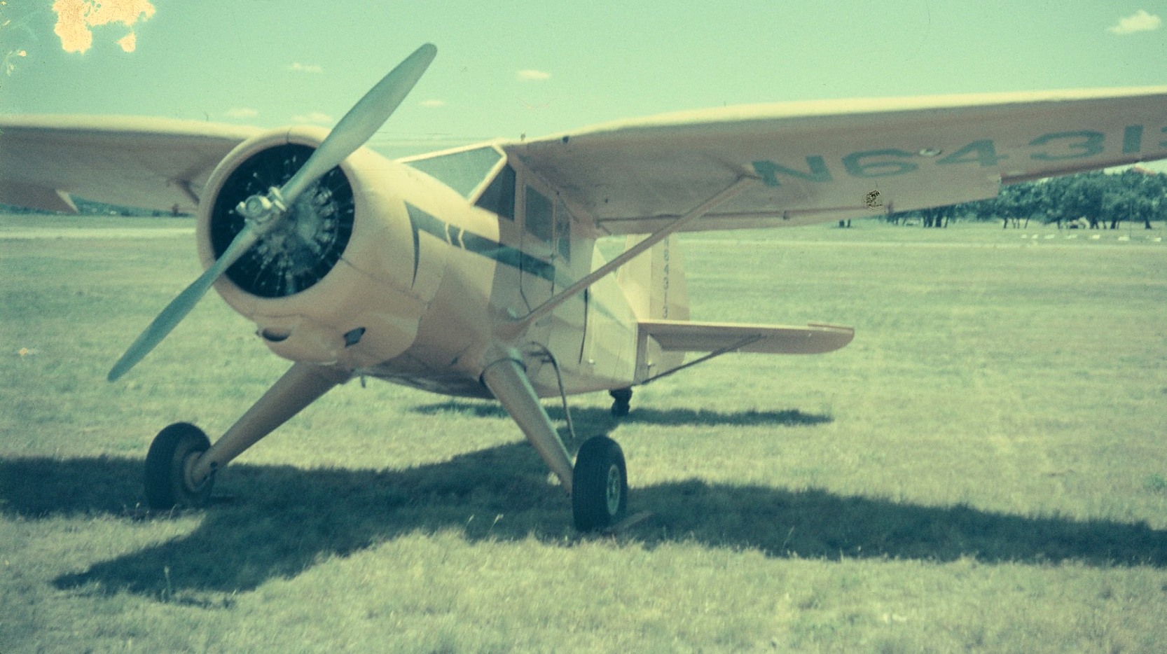
A 9/4/47 by Ernest Gaw of his wife Helen in front of their BT-13 & other aircraft at the Flying L Ranch (courtesy of Alden Gaw).
Alden Gaw reported, “She & my dad flew his BT-13 down for the 4th & 5th.”
The January 1949 San Antonio Sectional Chart (courtesy of Chris Kennedy) depicted Bandera Airpark as having a 2,600' hard-surface runway.
At some point between 1949-54, the airfield had been renamed "Flying L Ranch", as that is how it was depicted on the August 1954 World Aeronautical Chart (courtesy of Chris Kennedy).

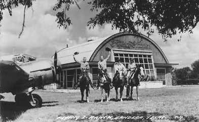
An undated photo of horse riders in front of a Braniff International Airways DC-3 with the Flying L Ranch clubhouse in the background (courtesy of Buck Shannon).
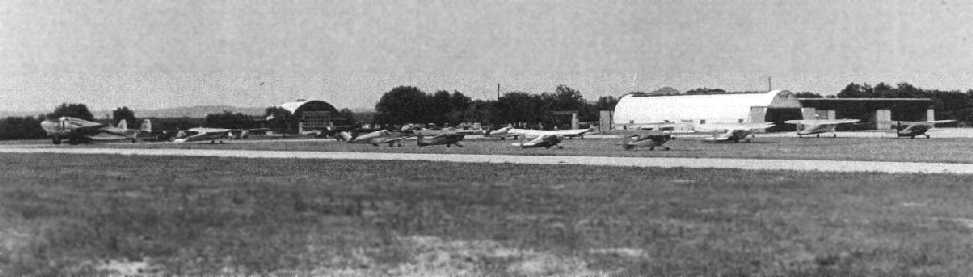
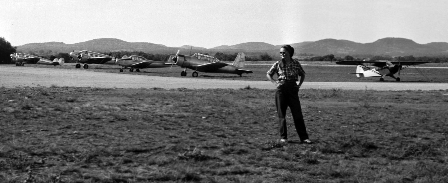
An undated photo of a large number of planes at the Flying L Ranch (courtesy of Buck Shannon).
An undated photo of a twin engine plane & horse riders in front of the Flying L Ranch clubhouse (courtesy of Steve Cruse).
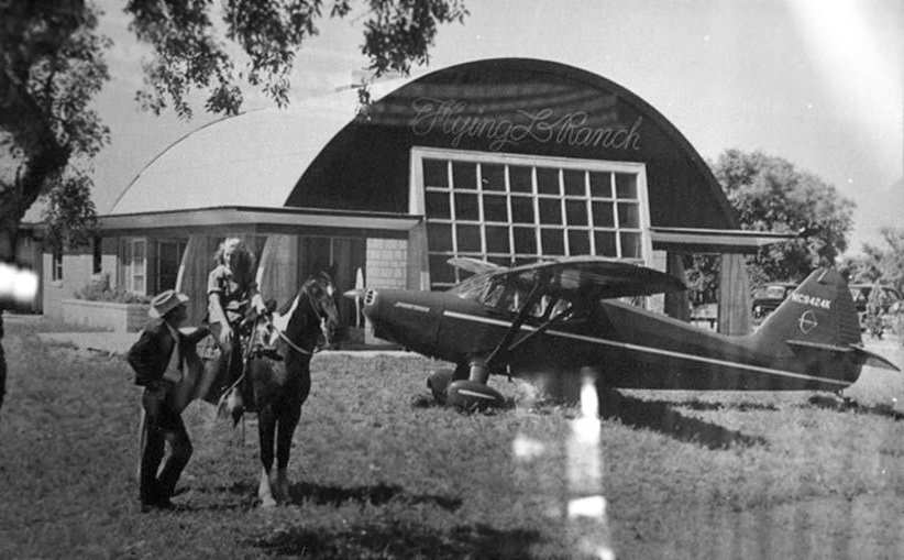
An undated photo of a Stinson 108-2 in front of the Flying L Ranch clubhouse
(courtesy of Bill Suffa, who found it hanging "on the wall of Busbee's Barbeque in Bandera, cowboy capital of the world").
An undated photo of the lodge at the Flying L Ranch, from a 1954 magazine article (courtesy of Steve Cruse).
An article in the 6/54 issue of Air Facts Magazine described the Flying L Ranch as "a lovely place.
The runway is paved & long, there's lots of hangar space,
and seeing his Twin Beech & Tri-Pacer were both there we were hoping to see Col. Lapham, but he was in New York."
It went on to describe Flying L as a "working ranch" with guest cottages, and said that "Flying L has steady traffic."
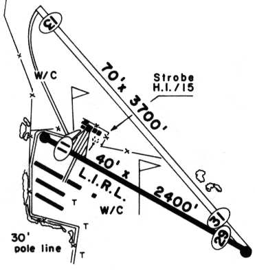
The 1962 AOPA Airport Directory described Flying L Ranch as consisting of a 2,640' paved Runway 15/33 & a 2,400' gravel Runway 5/23.
It also included the note, "Caution: Emergency use only."

A circa 1962 photo (courtesy of Dee Meador), which Dee Meador noted was “of an approach to the southbound runway of the Flying L Airport.
The photo is taken from my father's [George Meador's] Piper Tri-Pacer by his best friend Irvin Stevens at the end of a fishing trip to Port Aransas.”
An early 1960s photo of Dee Meador's father's Stinson Reliant gull-wing at Flying L.
Dee recalled, “His next plane was a Cessna 170 in which he taught me to fly at the Flying L.”
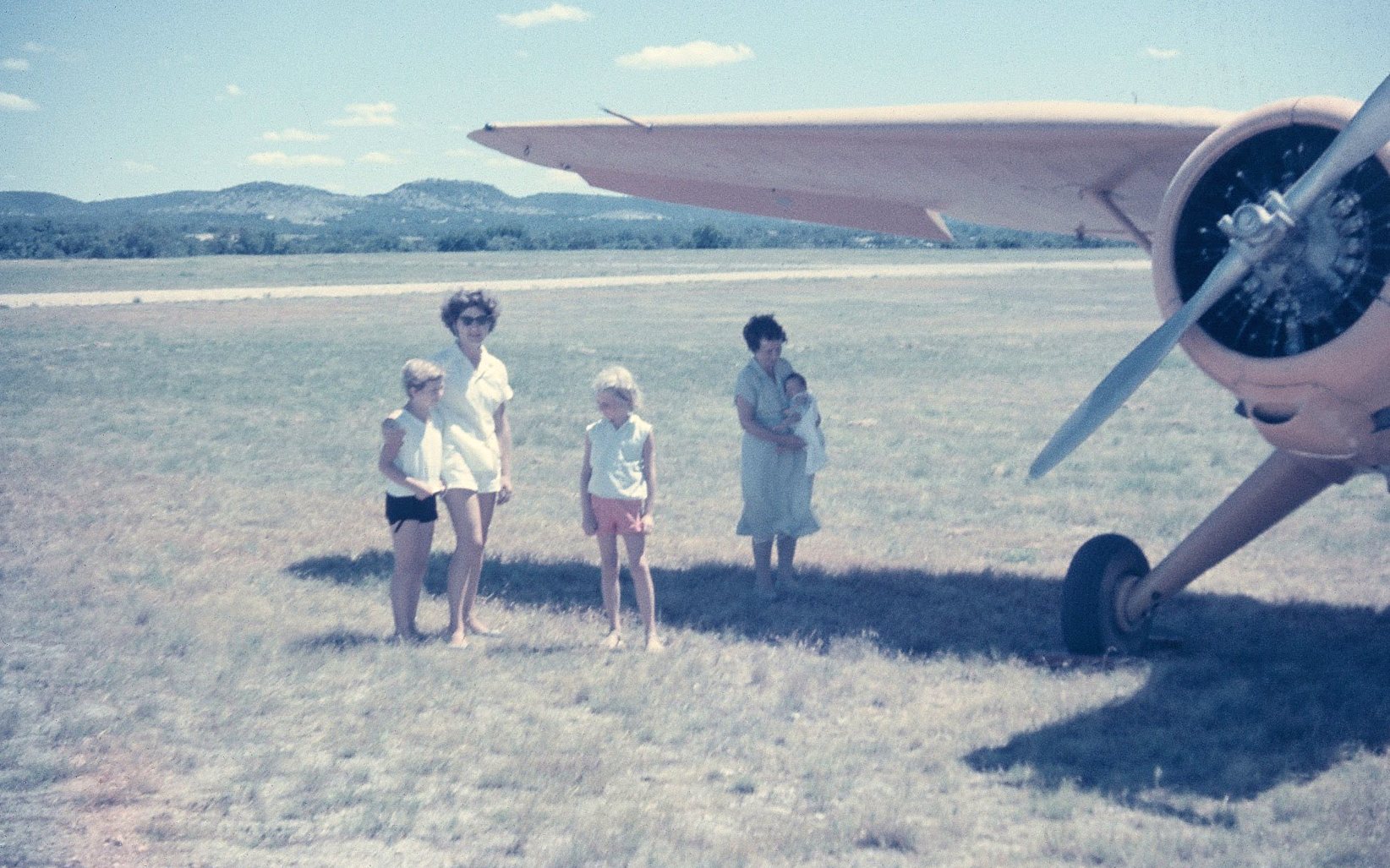
An early 1960s photo of Dee Meador's mother, sister and grandmother with her father's Stinson Reliant gull-wing at Flying L.
In the 1963 TX Airport Directory (courtesy of Steve Cruse),
the runway configuration was described as being much the same,
with the remarks, "Runways reported in very poor condition - use at own risk."
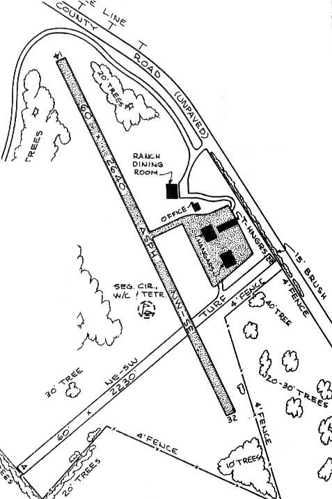
A paved ramp was depicted east of the runway, with 3 hangars,
and the office & the Flying L Ranch Dining Room sat adjacent to the north side of the ramp.
The guest ranch buildings were west of the airfield.
The manager was listed as Lucy Lapham.
A 2/4/63 aerial view depicted the Flying L Ranch as having a single northwest/southeast runway,
with a ramp & a few buildings on the east side.
A 2/4/63 aerial view depicted the Flying L Ranch as having a single northwest/southeast runway,
with a ramp & a few buildings on the east side.
Nelson Amen recalled, “My parents & I made a trip there in the 1960s looking at the land for sale at the Flying L Ranch.
They were at the start of the 'land-for-sale' efforts & the fly-in convenience.”
Dee Meador recalled, “Starting about 1966 my father, Dr. George Meador, taught me to fly at the Flying L in his Cessna 170.”
By the time of the 1970 TX Airport Directory (courtesy of Ray Brindle),
the primary runway remained unchanged,
but the crosswind gravel runway had been abandoned.
An undated photo of a Cessna 310 in front of the Flying L Ranch clubhouse from a circa 1973 brochure (courtesy of Ken Morris).
Ken recalled, “Dick Olivear was the shady promoter owner selling lots.”
An undated aerial view looking west at the Flying L Ranch taken from a Cessna 310 (note the wingtip tank in at the bottom)
from a circa 1973 brochure (courtesy of Ken Morris).
The December 1976 San Antonio Sectional Chart (courtesy of Jim Hackman)
depicted Flying L Ranch as a public-use airport having a 3,200' paved runway.
By the time of the 1985 TX Airport Directory (courtesy of Steve Cruse),
the primary Runway 15/33 had been lengthened to 3,260'.
The 1985 San Antonio Sectional Chart (courtesy of Steve Cruse)
depicted the Flying L Ranch as a public-use airport with a single 3,200' paved runway.
The Flying L Ranch Airfield was still listed in the 1986 Flight Guide (according to Chris Kennedy).
The last aeronautical chart depiction which has been located of the Flying L Ranch was on the May 1993 San Antonio Sectional Chart (courtesy of Ron Plante).
It depicted Flying L Ranch as a private airfield with a single 3,200' paved runway.
Nelson Amem reported, “One of the locals told me the airport closed in the mid-1990s. Very sad.”

The Flying L Ranch airfield was evidently closed for reasons unknown by 1995,
as a 1995 USGS aerial view looking northeast showed the center portion of the runway pavement had been removed,
but the north & south ends still remained intact, as well as the ramp area & hangars.
The Flying L Ranch airfield is no longer depicted at all (even as an abandoned airfield) on 2002 aeronautical charts.
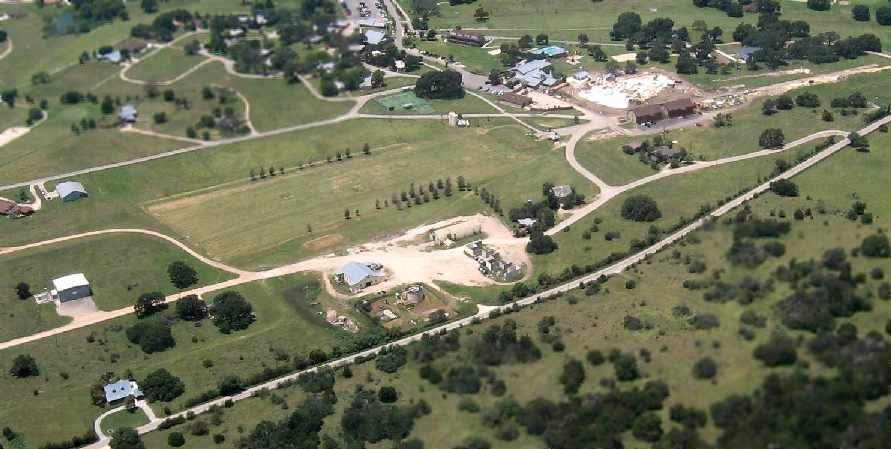
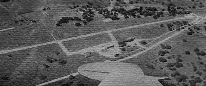
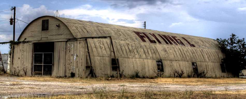
An August 2007 aerial view by Nelson Amen looking west at the site of the Flying L Ranch Airfield,
duplicating the perspective of the 1973 aerial photo.
Nelson observed, “The T-hangar roof is gone, and it now looks like a puzzle pattern of cinder blocks.
The 2 taxiways are gone, with the runway that used to be between them now a driving range.
Several of the trees have survived through the years & make excellent landmarks for the 40 years or so that have passed.
Most [of the former airport buildings] are still in place but now under alternate uses & in various stages of disrepair.”
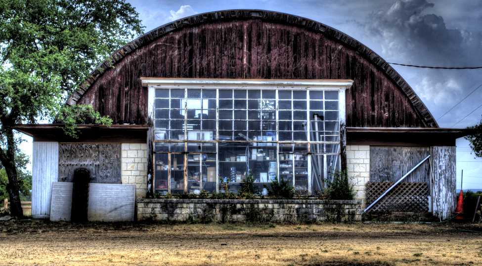
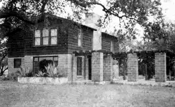
A 7/17/09 photo by Jonas Lamis of the former Flying L Ranch clubhouse.
Jonas reported, “The ranch is going strong as a dude ranch for weekenders, but the airstrip has been replaced by a driving range & the hangars have been disposed for other uses.
Today, this hangar is a rundown shop & storage space. Broken windows & boarded doors.
But if you look closely, you can still see the burned-in fade of the looped Rope Flying L cursive brand across the top of the building.”
A 7/17/09 photo by Jonas Lamis of the side of the former Flying L Ranch hangar. Jonas reported, “Once upon a time, it was a proud building.”
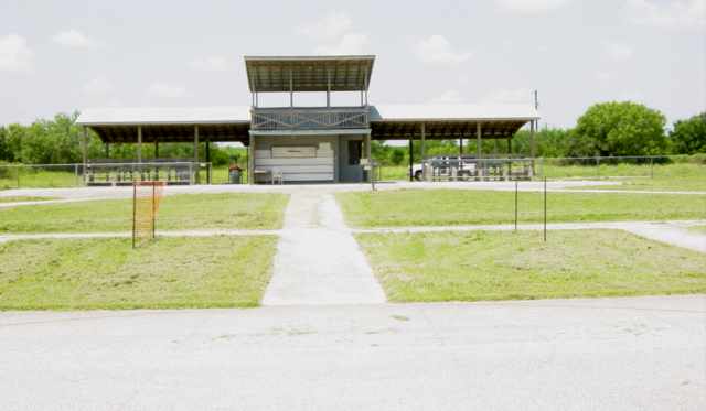
Buck Shannon reported in 2012, “We are in the process of renovating the Pilot's Lounge here on the ranch.”

A 2016 aerial view looking northeast shows the site of the Flying L Ranch is unrecognizable as a former airfield,
with the runway having been removed, but the clubhouse & hangar remain at the top-center of the photo.
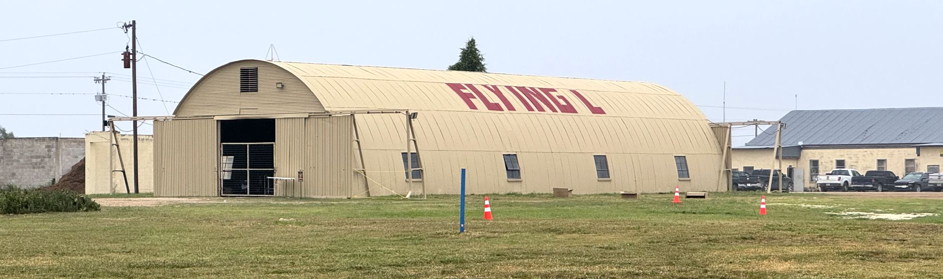
A 4/6/24 photo by Ted Dyson of the restored former Flying L Ranch hangar.
Ted reported, “I was surprised to discover that there had been an airport there. The pilot lounge & hangar have been repaired & painted.
The resort had a bunch of history pictures on display.”
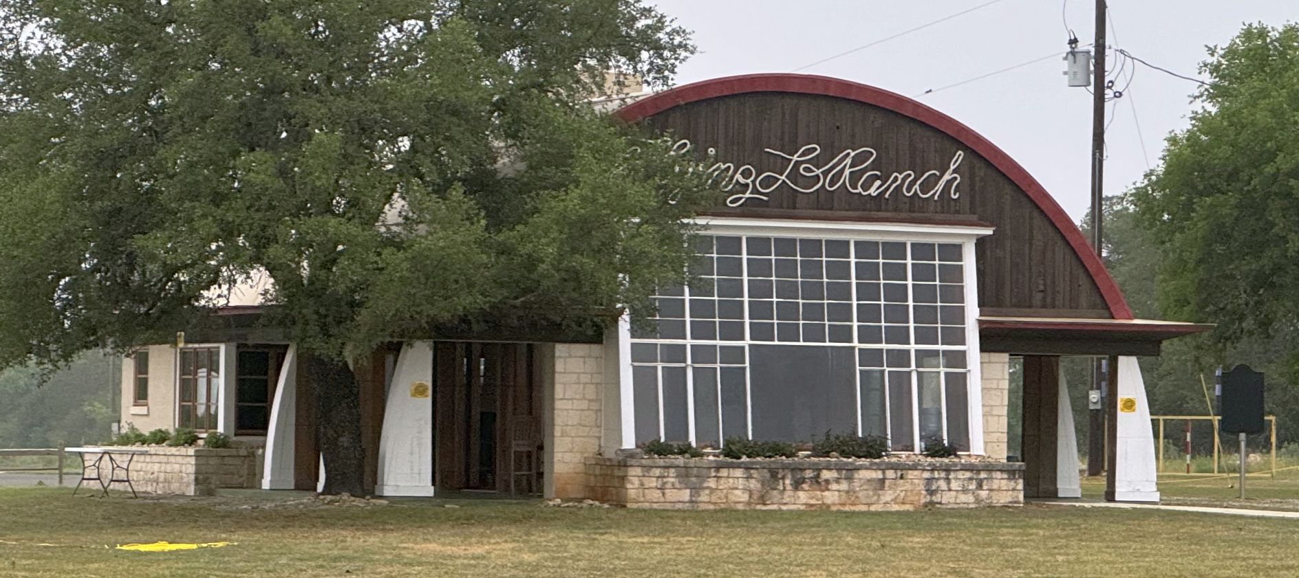
A 4/6/24 photo by Ted Dyson of the restored former Flying L Ranch pilot lounge.
The site of the Flying L Ranch Airfield is located west of the intersection of Bottle Springs Road & Whispering Winds.
Thanks to Bret Kepner for pointing out this airfield.
____________________________________________________
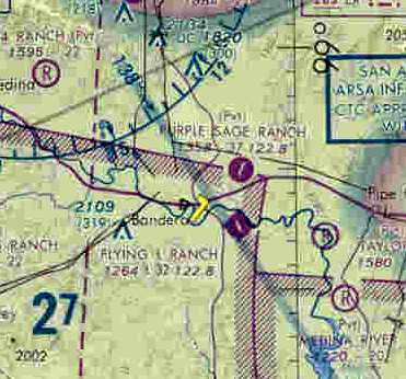
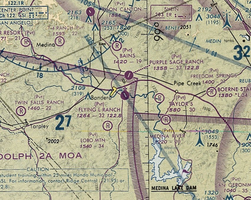
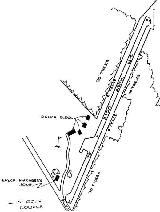
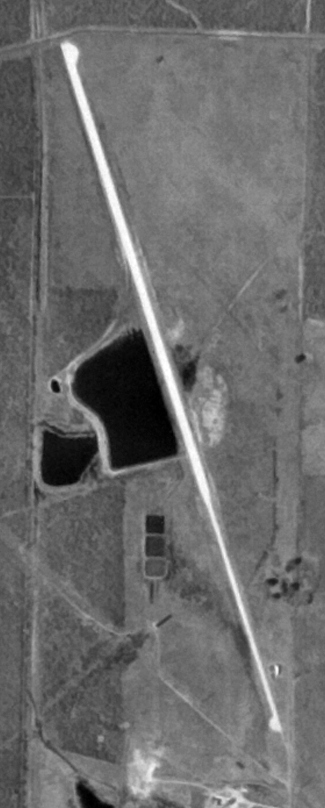
Pfeffer Ranch Airfield / Purple Sage Ranch (50TX), Bandera, TX
29.75, -99.03 (Northwest of San Antonio, TX)

Pfeffer Ranch Airfield, as depicted on the August 1948 San Antonio Sectional Chart.
Photo of the airfield while open has not been located.
The Pfeffer Ranch airfield was evidently established at some point between 1947-48,
as it was not yet depicted on the July 1947 San Antonio Sectional Chart.
The earliest depiction which has been located of Peffer Ranch Airfield was on the the August 1948 San Antonio Sectional Chart.
It depicted Pfeffer Ranch Airfield as having a 3,000' runway,
along with the Lost Valley Airfield adjacent to the southwest.
It was still depicted as Peffer Ranch Airfield on the the August 1952 San Antonio Sectional Chart.
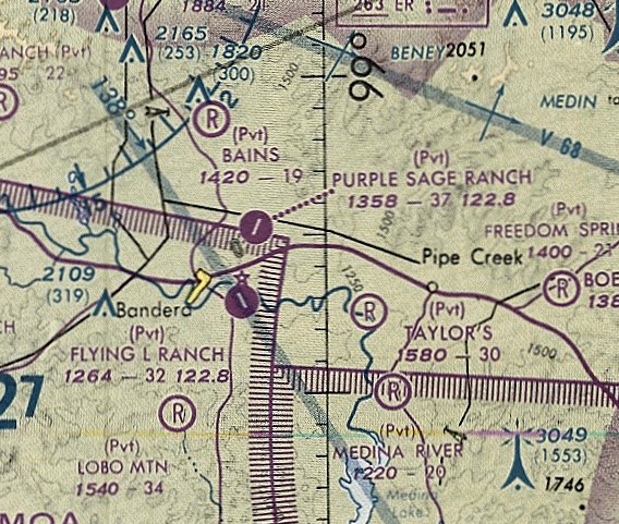
It was evidently renamed Purple Sage Airfield at some point between 1952-53,
as that is how it was labeled on the the February 1953 San Antonio Sectional Chart.
The 1962 AOPA Airport Directory described the Purple Sage Ranch Airfield
as having a 3,800' blacktop Runway 4/22,
and also included the note, "Caution: Emergency use only."
In the 1963 TX Airport Directory (courtesy of Steve Cruse),
the runway configuration was described as being much the same.
A paved ramp was depicted west of the runway, along with several ranch buildings.
The manager was listed as Luther James, Continental Oil Co.
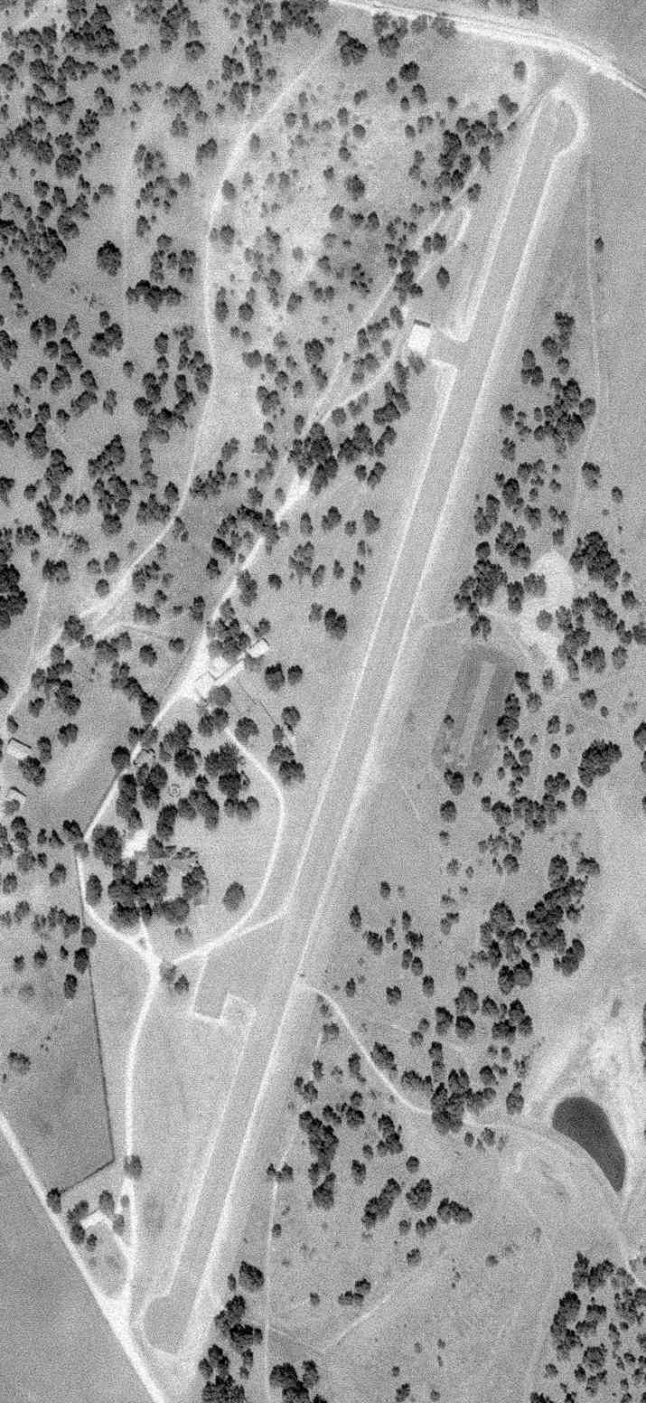
The only photo which has been located showing the Purple Sage Airfield while it was in use was a 1/24/69 USGS aerial view.
It depicted Purple Sage as having a paved northeast/southwest runway, with one small hangar on the west side.
The December 1976 San Antonio Sectional Chart (courtesy of Jim Hackman)
depicted Purple Sage Ranch as a private airfield having a 3,700' paved runway.
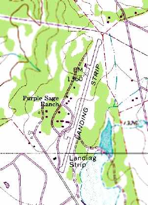
The 1982 USGS topo map depicted the Purple Sage Ranch as having a single paved runway.
The last aeronautical chart depiction which has been located of Purple Sage Ranch was on the May 1993 San Antonio Sectional Chart (courtesy of Ron Plante).
It depicted Purple Sage Ranch as a private airfield having a 3,700' paved northeast/southwest runway.
The Purple Sage Ranch airfield was apparently closed (for reasons unknown) at some point between 1993-95,
as the 1995 USGS aerial photo showed the runway marked with closed runway "X" symbols.
The airfield otherwise appeared to remain completely intact.
The Purple Sage Ranch airfield was still depicted as an abandoned airfield on 2002 aeronautical charts.
Chris Gaylord of ConocoPhillips reported the following in 2003:
"I just returned from a trip to the Ranch & actually walked the runway this morning.
The southern end has been shortened significantly from the diagram...
it now ends approximately even with the ranch buildings with just the northern edge of the ramp area still in existence.
The northern end appears to be as indicated on the diagram & aerial photo.
The field is definitely closed... I had a discussion about it with one of the Ranch employees earlier in the week.
The Ranch is owned by ConocoPhillips
and is used for company group meetings / training as well as a recreational facility for employees."
Peyton Inge reported in 2016, “Purple Sage was sold earlier this year to Warriors Heart Foundation & the runway is now down to approximately 2,500’.”
The airfield site is located at the northern terminus of Purple Sage Road, one mile north of Route 16.
____________________________________________________
Art Stewart Airport / Standard Industries Airfield, San Antonio, TX
29.34, -98.66 (Southwest of Downtown San Antonio, TX)
Art Stewart Airport, as depicted on the June 1972 San Antonio Sectional Chart (courtesy of David Brooks).
Art Stewart Airport was evidently established during 1971,
as no airfield was yet depicted at this location on the 1967 USGS topo map or the January 1971 San Antonio Sectional Chart (according to David Brooks).
The first depiction which has been located of Art Stewart Airport
was on the June 1971 San Antonio Sectional Chart (according to David Brooks).
The June 1972 San Antonio Sectional Chart (courtesy of David Brooks)
depicted Stewart as a public-use airport with a single 4,600' paved northwest/southeast runway.
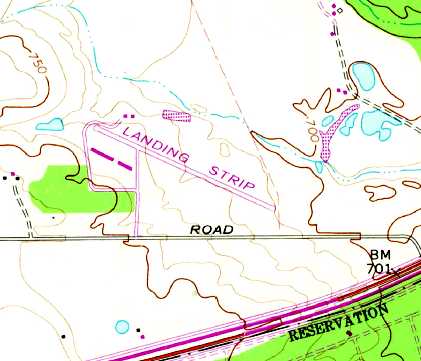
The 1973 USGS topo map depicted the single unpaved northwest/southeast runway of the Art Stewart Airfield, labeled simply as “Landing Strip”.
A 2/27/73 USGS aerial photo shower Art Stewart Airport to have a single paved northwest/southeast runway.
The status of Art Stewart Airport apparently changed to a private field at some point between 1972-76,
as the 1976 AOPA Airport Directory (according to David Brooks) described the field as a private airport, closed to the public.
It was said to have a single 4,606' asphalt Runway 15/33.
Stewart was depicted as a private airfield on the December 1976 San Antonio Sectional Chart (courtesy of Jim Hackman).
Art Stewart Airport apparently was closed [for reasons unknown] at some point between 1976-80,
as it was depicted as an abandoned airfield on the June 1980 San Antonio Sectional Chart (courtesy of David Brooks).
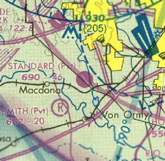
At some point between 1980-82, the site of the former Art Stewart Airport was apparently reused by the Standard Oil Company for a private airfield.
The December 1982 San Antonio Sectional Chart (courtesy of David Brooks) depicted Standard as a private airfield with a single 4,600' paved northwest/southeast runway.
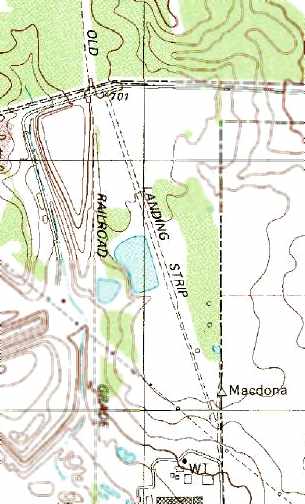
The 1991 USGS topo map depicted the single runway of the Standard Industries Airfield, labeled simply as “Landing Strip”.

The last aeronautical chart depiction which is available showing Standard Airfield was on the May 1993 San Antonio Sectional Chart (courtesy of Ron Plante).
It depicted Standard as a private airfield with a single 4,600' paved northwest/southeast runway.
The last aeronautical chart depiction which has been located showing the Standard Airfield
was on the 1995 San Antonio Sectional Chart (according to David Brooks).
The Standard Industries Airfield was evidently closed (for reasons unknown) during 1995.
Richard Storm reported, “In 1995 the San Antonio Prop Busters Radio Control Club
acquired the use of the northern 600' of the old runway for use as a radio-controlled model airplane airfield.
The property was owned by Waste Management Incorporated & was leased to the SAPB for recreational use.
The runway was capped & the 'X' markers added as it was no longer suitable for full-scale [aircraft] use.
The structure along the southwest side of the runway is a large pole-type shade structure for spectators & for working on the model aircraft.
There was a large concrete apron added as well as concrete taxiways & pilot stations.
The membership of SAPB invested a considerable amount of money & effort
in creating a premiere radio control flying site as initial information provided
led us to believe it would be 20 years before there was any need to develop the property for landfill use.
There was a large overflight area opposite the shade structure which provided for a safe & expansive flying site.
Many nationally-advertised radio control events were held at the location.
The site was especially suited for 'Giant Scale' aircraft with wingspans up to 12 feet.
At peak we had over 200 members of the SAPB primarily because of this flying site.”
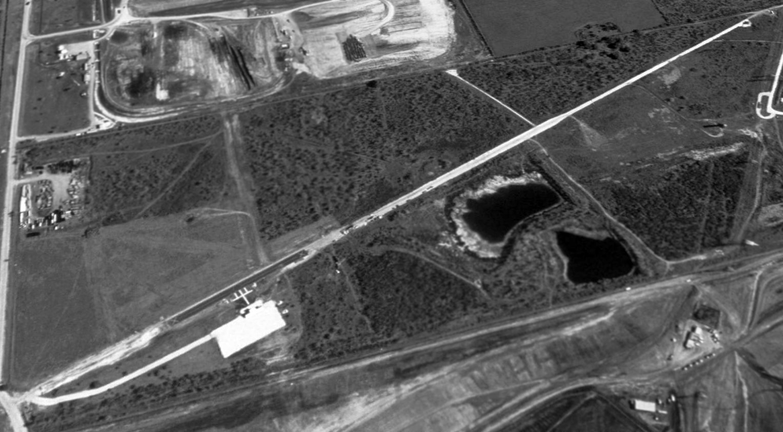
A 1995 USGS aerial view looking southeast showed the Standard Industries Airfield consisted of a single 4,600' paved runway.
The newer 700' portion at the northern end had been added for radio-controlled model airplane operation.
Standard Industries Airfield was labeled "Standard (Pvt) (Closed)" on the 1998 World Aeronautical Chart.
Richard Storm reported, “Starting in 2001, the landfill began encroaching on the [SAPB] flying site.”
A 2002 aerial view looking southeast showed the landfill starting to encroach on the former Standard Industries Airfield.
The more recent model-airplane runway portion still remained, as well as the small buildings alongside the ramp.
A circa 2002 photo by Bob Severence (courtesy of Richard Storm),
of the radio-controlled aircraft shade building constructed on the west side of the former Standard Industries Airfield.
Richard noted, “From [this picture], you should get a good idea of the amount of work & investment we put into the facility expecting 20+ years of use.
We actually got 5 good years, 5 spotty years where at times it was not even usable due to construction equipment parked along side the runway.
Now it is just a memory.”
According to Richard Storm, “In December of 2005 the [SAPB] lease was terminated.”
Richard Storm reported in 2006, “The entire area represented by the original Art Stewart Airport is now just a hole in the ground to collect the refuse of modern society.
SAPB has moved on to a very modest grass field south of town & continues to look for a location that would be anywhere near what we had at the abandoned airport.
Unfortunately, abandoned airports make great places for houses, schools & soccer fields
which carry much more economic incentive than maintaining open property suitable for aviation use, model or full-scale.”
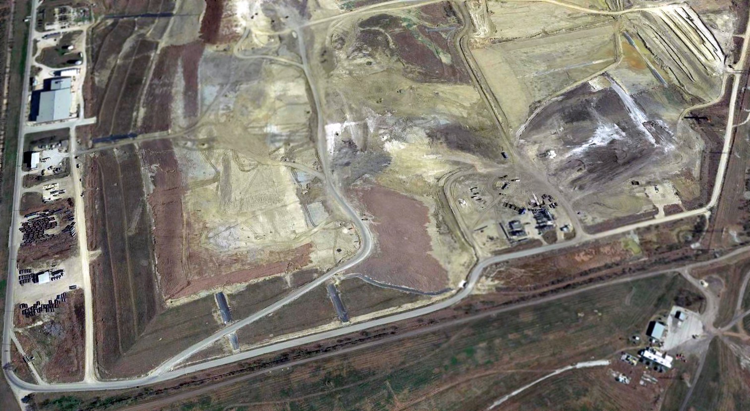
A 2017 aerial view looking southeast showed the landfill has erased all traces of the former Standard Industries Airfield.
The site of the Standard Industries Airfield is located north of the intersection of Reliable Drive & Nelson Road, adjacent to the southwest side of the Lackland AFB property.
____________________________________________________
Westside Executive Airport / Westside Airpark (T99), San Antonio, TX
29.39, -98.68 (Southwest of Downtown San Antonio, TX)
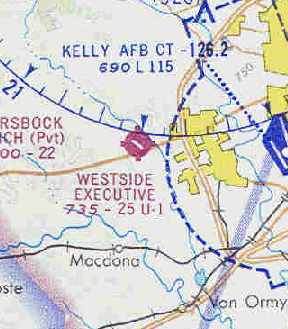
Westside Executive, as depicted on the January 1970 San Antonio Sectional Chart (courtesy of Chris Kennedy).
Photo of the airfield while open has not been located.
This general aviation airport was apparently built at some point between 1968-69,
as it was not depicted on the 1966 USGS topo map, a 1967 aerial photo, or the January 1968 San Antonio Sectional Chart.
The earliest reference to Westside Airpark which has been located is an NTSB report of a 1969 crash of a Piper PA-32 at the airport.
The earliest depiction of Westside which has been located
was on the January 1970 San Antonio Sectional Chart (courtesy of Chris Kennedy).
It depicted Westside Executive as having a single 2,500' paved runway.
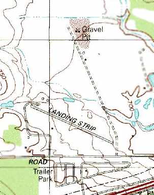
The 1973 USGS topo map depicted Westside as having a single paved northwest/southeast runway, labeled simply as “Landing Strip”,
with 2 buildings each on the southwest & northwest sides.

The earliest photo which has been located of Westside Airpark was a 1973 aerial view.
It depicted Westside as having a single paved northwest/southeast runway, with several hangars & 6 light aircraft on the southwest & northwest sides.
The last aeronautical chart depiction which has been located of Westside Airpark
was on the December 1976 San Antonio Sectional Chart (courtesy of Jim Hackman).
It depicted Westside Airpark as having a 2,500' paved runway.
Joseph Georges recalled, “Westside Airpark... I flew there [in the] late 1970s.
They where the only airfield in the San Antonio area to fly Grumman single-engine planes! They were great to fly.
I knew Tony Crosby who was the operator, Bob Schulnick was chief mechanic.
The Certified Flight Instructors were Wallace Long & Sheryl Foss.”
The 1982 AOPA Airport Directory (courtesy of Ed Drury) described the field as having a single 2,500' asphalt Runway 11/29.
The operator was listed as Westside Air Park, Inc.
The 1985 TX Airport Directory (courtesy of Steve Cruse) depicted Westside Airpark as having 2 runways: a 2,400' asphalt Runway 11/29 & a 3,700' unpaved Runway 13/31.
A number of t-hangars were clustered around the west end of Runway 11/29, and the airport also had an EAA clubhouse (the first building for EAA Chapter 35).
The airport manager was listed as Tony Crosby.
Westside Airpark was evidently closed at some point in 1985, as it was no longer depicted on the December 1985 San Antonio Sectional Chart.
Joseph Georges recalled, “The airfield closed because the operator Tony Crosby was offered to be bought out by a home builder (Ray Ellison),
and so he sold & went into retirement about the mid-1980s.”
The Westside Airpark was evidently closed by 1993, as it was labeled merely "Landing Strip" on the 1993 USGS topo map.
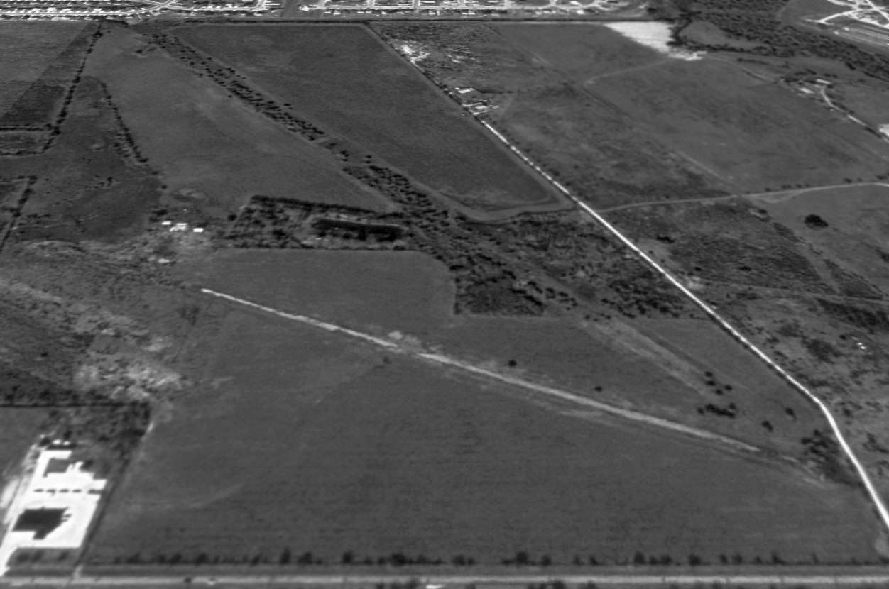
A 1995 USGS aerial view looking north showed Westside Airpark after its abandonment. The former Runway 11/29 pavement was overgrown, and the former grass runway was overgrown as well.
All of the former hangars & other buildings had been removed.
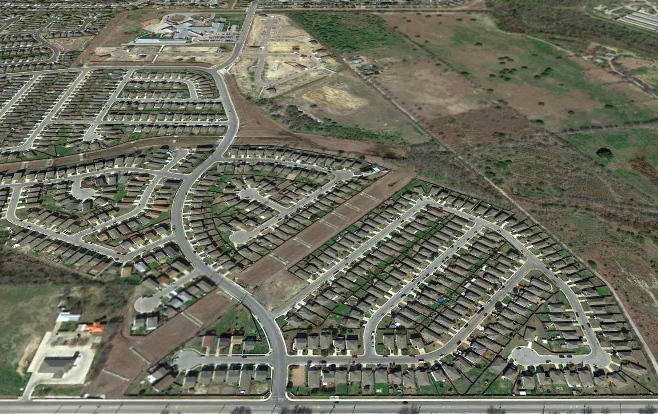
A 2015 aerial view looking north showed that all remains of Westside Airpark had been obliterated, with the site having been covered by housing.
The site of Westside Airpark is located northwest of the intersection of Route 90 & Kriewald Road.
____________________________________________________
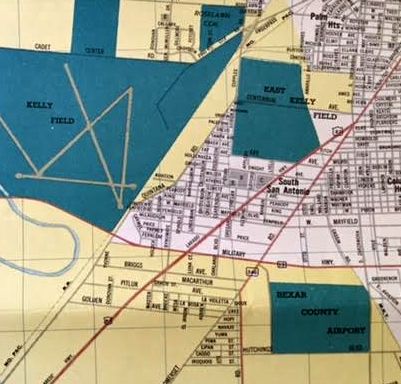
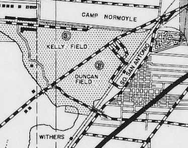
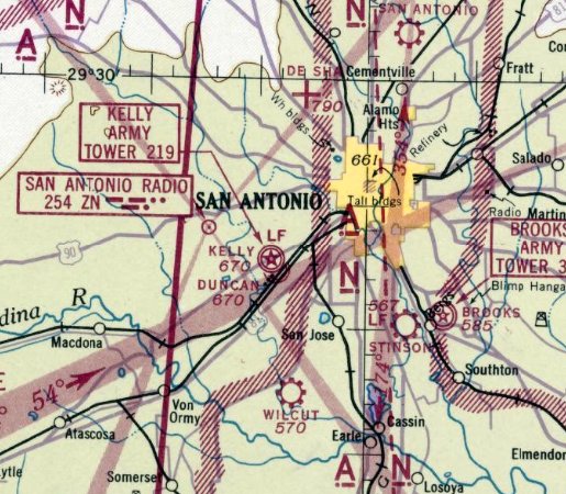
Kelly Field #1 / Duncan Field, San Antonio, TX
29.38, -98.56 (East of Kelly AFB, TX)
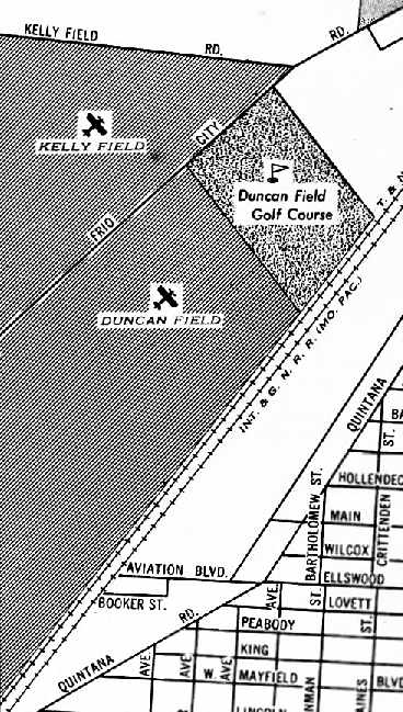
Duncan Field, as depicted on the October 1934 San Antonio Sectional Chart.
Kelly Field was established in 1917, as one of the Air Corps' first aviation training centers.
The Army in established an aircraft repair depot at Kelly Field #1 in 1921.
The depot was expanded to become one of 4 Field Service Sections (Air Depots) in the nation belonging to the AAF's Materials Division.
In the mid 1920s, Kelly Field #1 was renamed Duncan Field.
Strangely, Duncan Field was not depicted at all on the February 1934 San Antonio Sectional Chart.
The earliest depiction of Duncan Field which has been located was on the October 1934 San Antonio Sectional Chart.
It depicted Duncan Field along with Kelly Field immediately to the northwest.
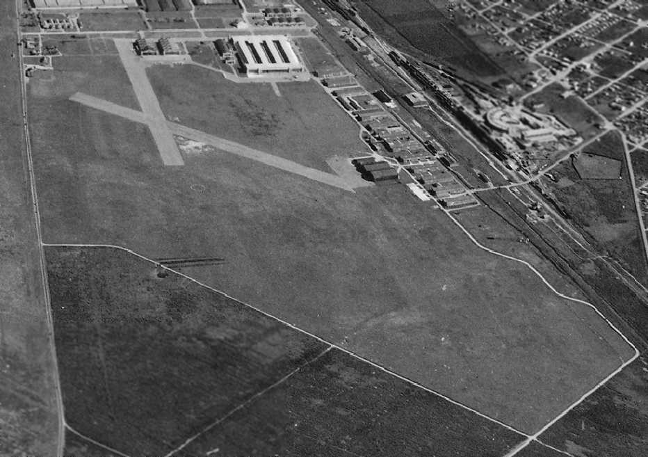
The earliest photo of Duncan Field which has been located was an 11/20/35 National Archives aerial view looking east (courtesy of Brian Rehwinkel).
It depicted Duncan Field as having 2 paved runways, with 2 checkerboard-roofed hangars on the east side, and several smaller hangars on the southeast side.
The larger Kelly Field was just across the road to the northwest.

A pair of vintage pilot's wings from the San Antonio Air Depot's Duncan Field.
Duncan Field, as depicted on a 1941 map (courtesy of Robert Thaler).
According to the book "The Wings of Change" (courtesy of Steve Cruse),
in 1941 it was proposed by the Army that adjacent Kelly Field (to the west) be absorbed into Duncan Field,
with the combined facility being dedicated to aircraft maintenance & supply.
The last aeronautical chart depiction of Duncan Field which has been located was on the September 1942 San Antonio Sectional Chart.
It depicted Duncan Field along with Kelly Field immediately to the northwest.
In early 1943 Duncan Field was absorbed into Kelly Field (the opposite of what had been proposed a few years before).
Duncan Field was no longer depicted on the January 1944 San Antonio Sectional Chart.
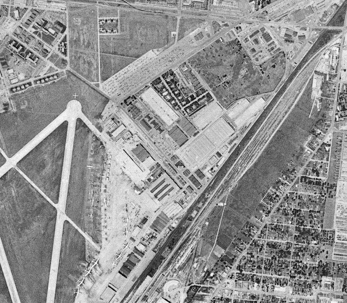
A 4/24/53 USGS aerial view of the site of Duncan Field showed 3 former hangars remained in the center of the photo,
and the ramps & runways of adjacent Kelly Field had covered the western portion of the Duncan Field site.
Kelly AFB was closed in the 1990s, and redeveloped for commercial purposes, becoming known as KellyUSA.
A circa 2006 aerial view looking north at 3 former Duncan Field hangars.
Former Kelly employee Jesse Ramirez reported in 2007 that a former Duncan Field control tower also remains intact.

A March 2012 photo by Tom Townsend of what appears to be a former control tower at the site of Duncan Field,
“located on the very next building Northwest from the hangars.”
The tower appears somewhat unusually-proportioned for the airfield control tower,
being somewhat shorter & having a wider cab than a typical control tower – perhaps it had some use other than aviation?
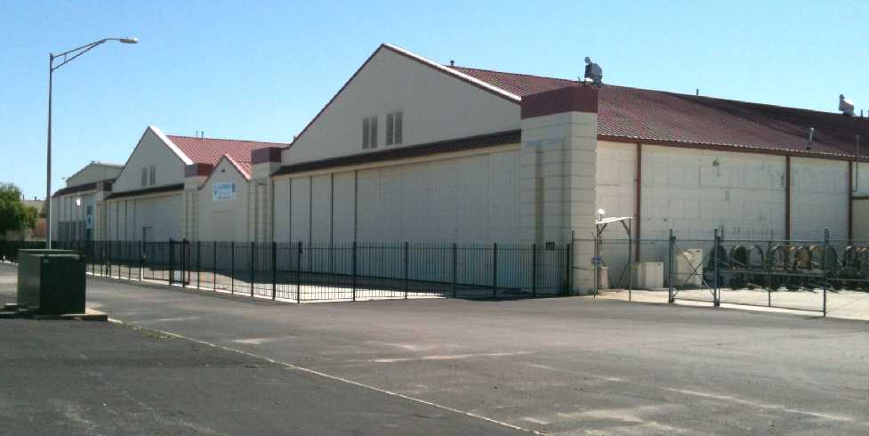
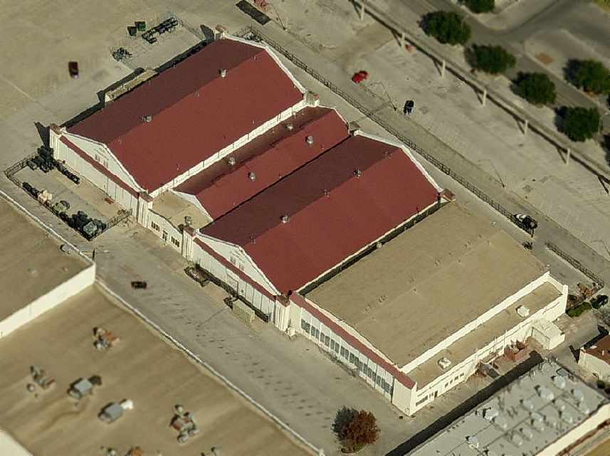
A March 2012 photo by Tom Townsend of hangars which remain at the site of Duncan Field,
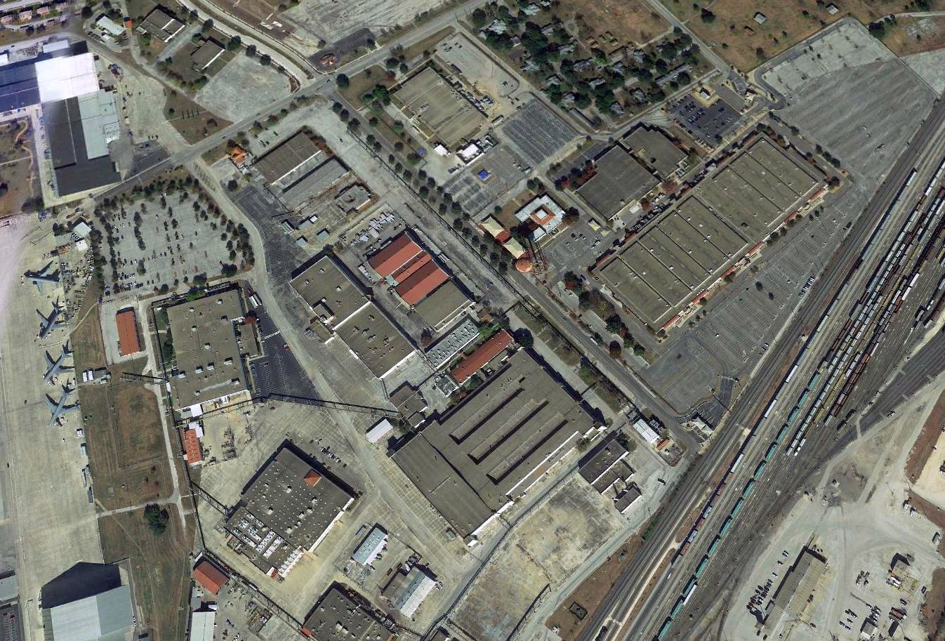
As seen in a 2018 aerial view looking north, the site of Duncan Field has been largely covered with buildings.
However, three former hangars still remain standing (center of photo).
Note the 4 brand-new KC-46 tankers undergoing completion activities on the Kelly Field ramp on the left side of the photo.
According to San Antonio native Robert Thaler, "Duncan Field was located to the west of the railroad yards, and to the southeast of Duncan Drive.
The big maintenance building, #375, is located on what was once Duncan Field."
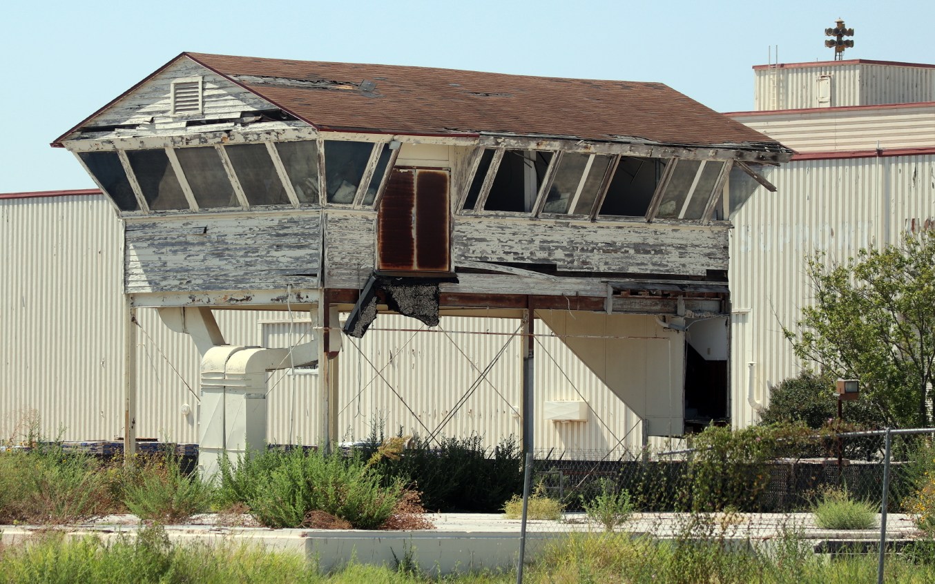
An 8/29/0 photo by Don Rogers of a former Duncan Field control tower cab.
Don Rogers reported, “I'm surprised that the control tower cab is still standing as the building surrounding it [in the 2012 photo] has been demolished.
The east side of the field is rapidly being redeveloped for new commercial uses
and the old buildings are being demolished one by one & being replaced by new industry.
The commercial side of the former base is no longer known as 'KellyUSA' but is now called 'Port San Antonio'.”
____________________________________________________
Or if you prefer to contact me directly concerning a contribution (for a mailing address to send a check),
please contact me at: paulandterryfreeman@gmail.com
If you enjoy this web site, please support it with a financial contribution.
____________________________________________________
This site covers airfields in all 50 states.