Abandoned & Little-Known Airfields:
West Texas
© 2002, © 2026 by Paul Freeman. Revised 3/23/26.
This site covers airfields in all 50 states: Click here for the site's main menu.
____________________________________________________
Please consider a financial contribution to support the continued growth & operation of this site.
Delaware Springs Intermediate Field (revised 3/23/26) - (Original) Fort Stockton Airport / Win Field (revised 7/2/23) - Hudspeth Intermediate Field (revised 7/2/23) - Kermit Airport / Robinson Airport (revised 3/25/22)
Milehigh Community Airport (revised 8/12/24) - Pyote AAF / Pyote AFB / Pyote Airfield (revised 3/25/22) - Salt Flat Intermediate Field (revised 7/2/23) - Worsham Airport (revised 7/2/23)
____________________________________________________
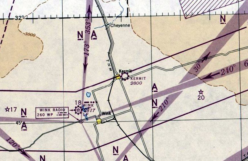
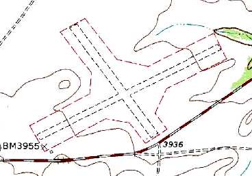
Kermit Airport / Robinson Airport, Kermit, TX
31.853, -103.072 (East of El Paso, TX)
Kermit Airport, as depicted on the July 1945 El Paso Sectional Chart.
Photo of the airfield while in use has not been located.
This small West Texas general aviation airport was evidently established at some point in 1945
(like hundreds of other small airports in the US post-WW2 aviation boom),
as it was not yet depicted on the January 1945 El Paso Sectional Chart.
The earliest depiction which has been located of Kermit Airport was on the July 1945 El Paso Sectional Chart.
It depicted Kermit as a commercial/municipal airport.
It was still depicted as Kermit Airport on the March 1954 El Paso Sectional Chart.
At some point in 1954, Kermit Airport was evidently renamed Robinson Airport
as that is how it was depicted on the September 1954 El Paso Sectional Chart.
Robinson Airport was evidently closed (for reasons unknown) at some point between 1954-56,
as it was no longer depicted on the September 1956 El Paso Sectional Chart.
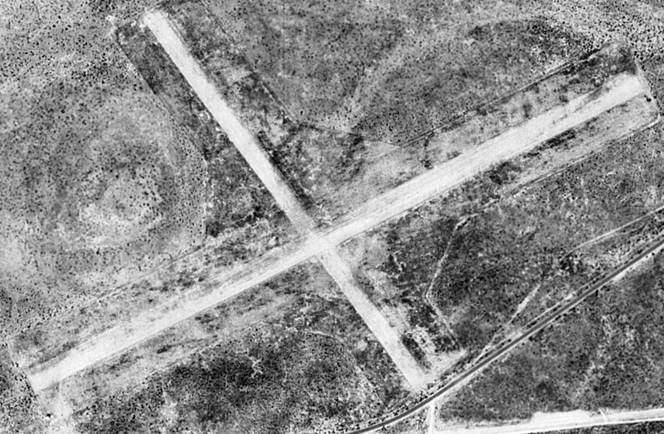
The earliest photo which has been located of Robinson Airport was a 1968 aerial view.
It depicted Robinson as having an asphalt northeast/southwest runway, along with 3 unpaved runways.
A row of hangars was on the south side, but there were no aircraft visible on the field.
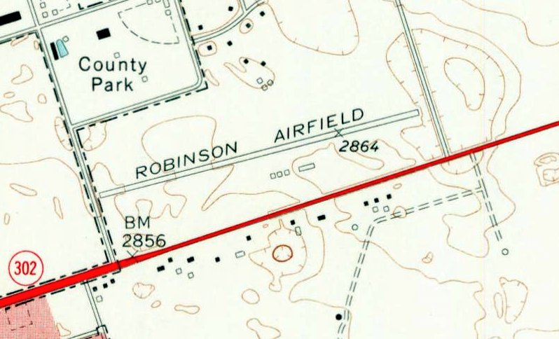
The earliest topo map depiction which has been located of Robinson Airport was on the 1970 USGS topo map (courtesy of Lee Corbin).
It depicted “Robinson Airfield” as having a paved northeast/southwest runway, but the 3 unpaved runways were not depicted.
Four small buildings were depicted on the south side.
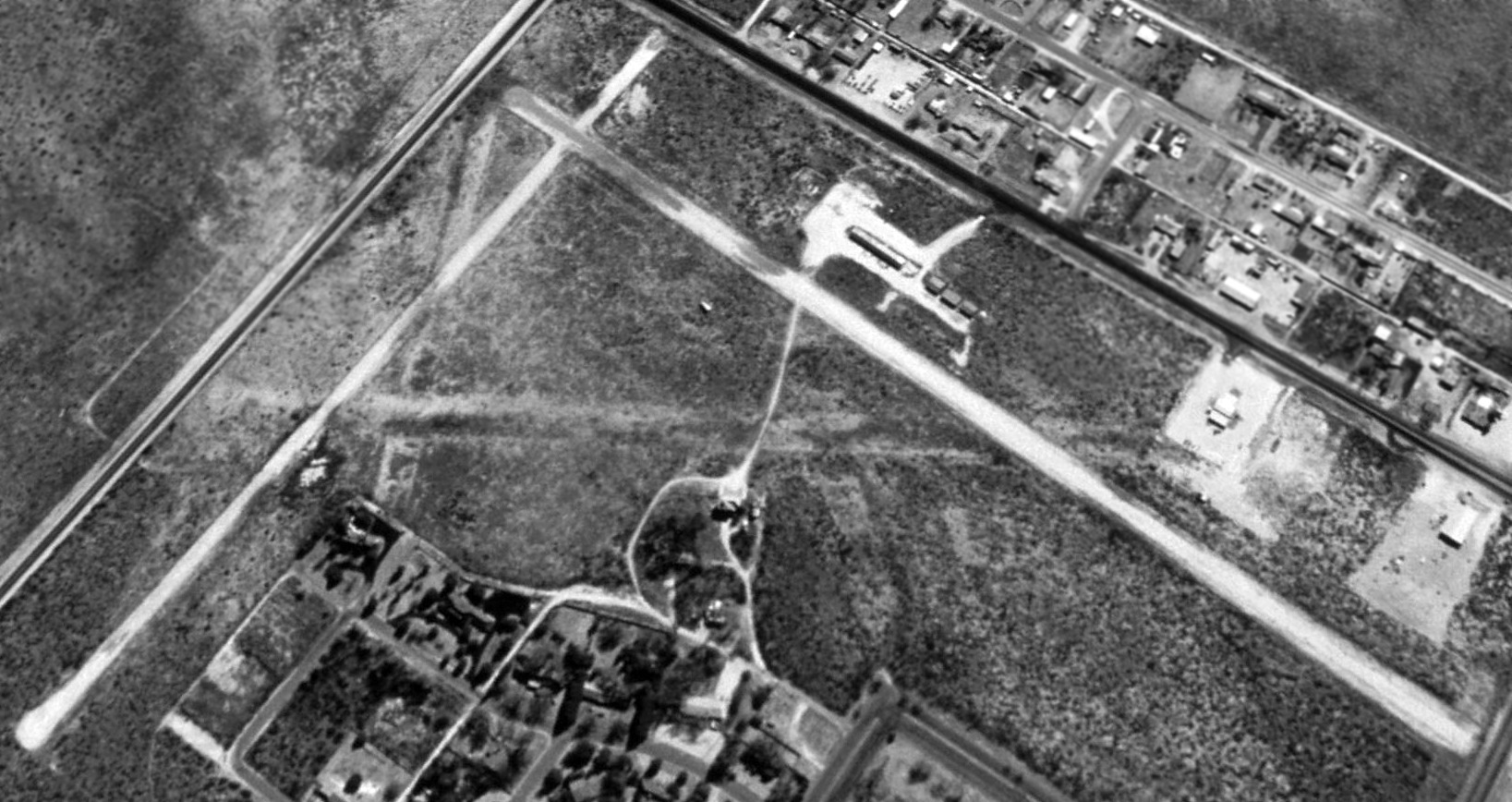
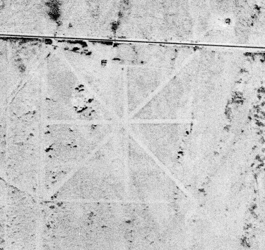
The earliest depiction which is available of Robinson Airport was a 1996 USGS aerial view looking southeast.
It depicted Robinson as having 2 paved runways & 2 unpaved runways.
A row of hangars was on the south side, but there were no aircraft visible on the field.
Phillip Rathbun observed, “The field was visible from 1996 to 2013-15. The last of the field disappeared in 2018.”
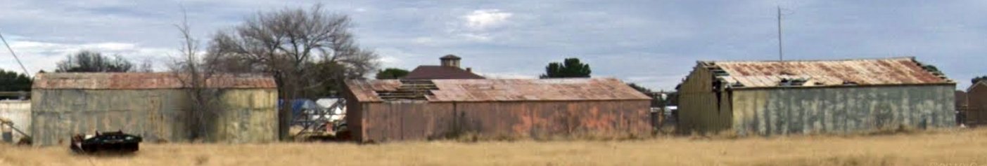
A circa 2016-2019 photo of the former hangars which remain at the site of Robinson Airport (courtesy of Lee Corbin).
A circa 2016-2019 photo of the former hangars which remain at the site of Robinson Airport (courtesy of Lee Corbin).
A 2018 aerial view looking southeast at the site of Robinson Airport showed the site to be unrecognizable as a former airport,
with only portions of the paved northeast/southwest runway still remaining, but the row of hangars still remained standing.
A 2018 aerial view looking southeast at the former hangars which remain at the site of Robinson Airport.
Thanks to Lee Corbin for pointing out this airfield.
____________________________________________________
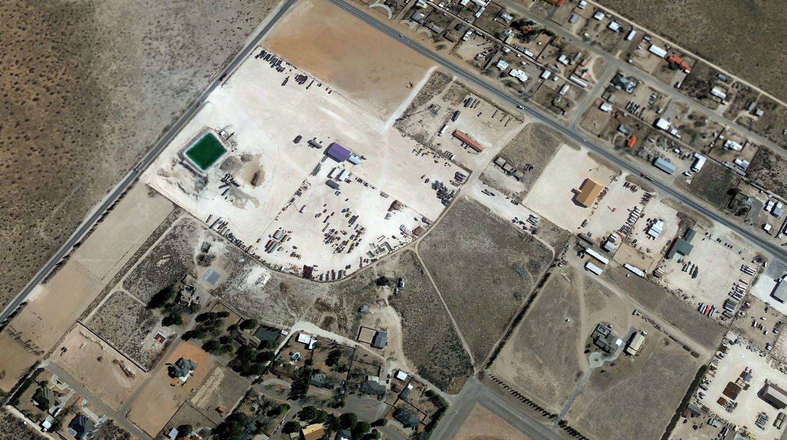
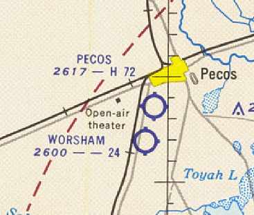
31.36, -103.53 (Southwest of Pecos, TX)
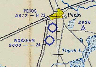
Worsham Airport, as depicted on the September 1952 El Paso USAF Sectional Chart (courtesy of Chris Kennedy).
Photo of the airfield while in use has not been located.
This small, short-lived airfield was evidently established at some point between 1950-52,
as it was not yet depicted at all on the February 1950 El Paso Sectional Chart.
The earliest depiction of the Worsham Airport which has been located
was on the September 1952 El Paso USAF Sectional Chart (courtesy of Chris Kennedy).
The Aerodromes table on the chart described Worsham as having 2 unpaved runways, with the longest being 2,400'.
Clifford Kidd recalled, “Worsham's strip was used for cropdusting since it was built back in the 1950s.
Worsham used to be the biggest cropdusting operator in the Pecos River Valley.
My father bought a Piper Pawnee from him years ago.
It was one of the first cropdusting aircraft to be converted for liquid spray work as well.
This little field has always had a dirt runway.”

The earliest photo which has been located of Worsham Airport was a 5/4/54 USGS aerial view,
which depicted Worsham as having 2 perpendicular unpaved runways & 2 hangars along the west side.
The August 1955 El Paso Sectional Chart (courtesy of David Brooks)
depicted Worsham as having a 2,400' unpaved runway.
Worsham was apparently closed at some point between 1955-58,
as it was no longer depicted at all on the March 1958 El Paso Sectional Chart (according to Chris Kennedy)
or listed among active airfields in the 1963 TX Airport Directory (courtesy of Steve Cruse).
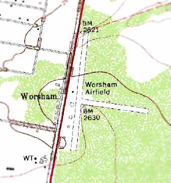
The 1971 USGS topo still depicted “Worsham Airfield” as having 2 runways,
with several buildings along the west side of the field.
Worsham's 2 runways were still depicted on the 1980 USGS topo map, but they were labeled simply as “Landing Strips”.

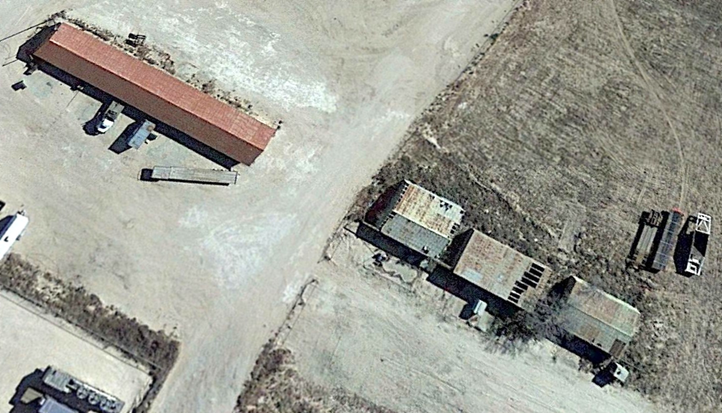
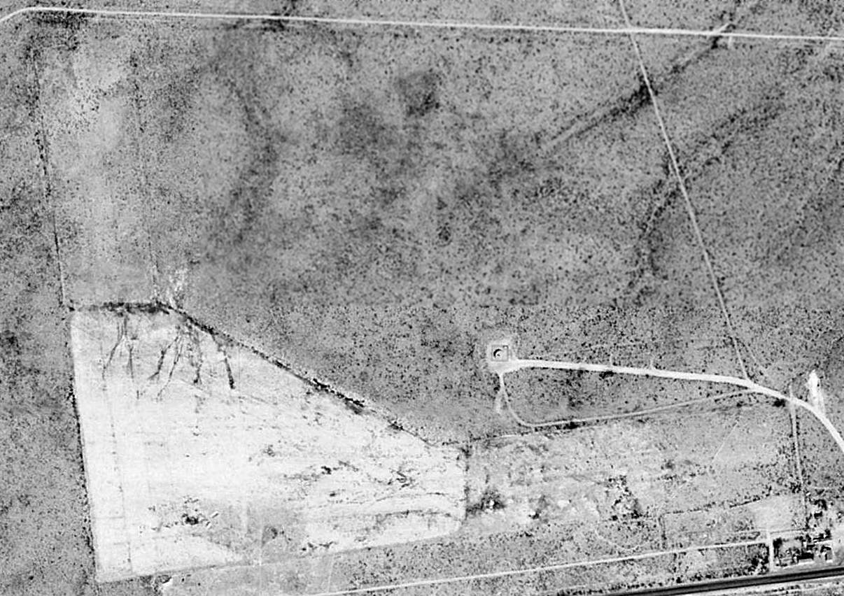
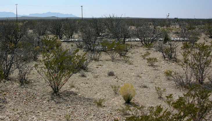
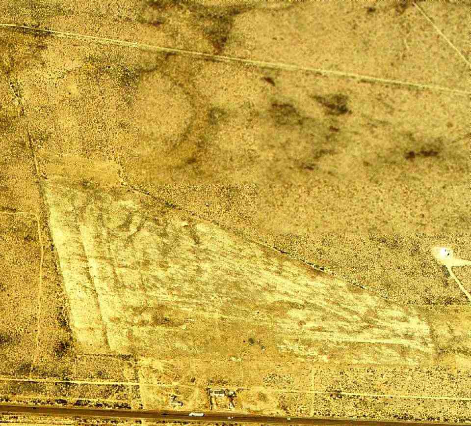
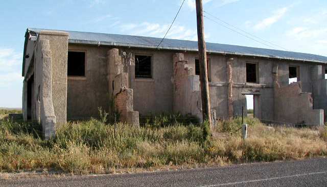
A 1996 USGS aerial view looking northwest at the hangars & runway remains at at the site of Worsham Field.
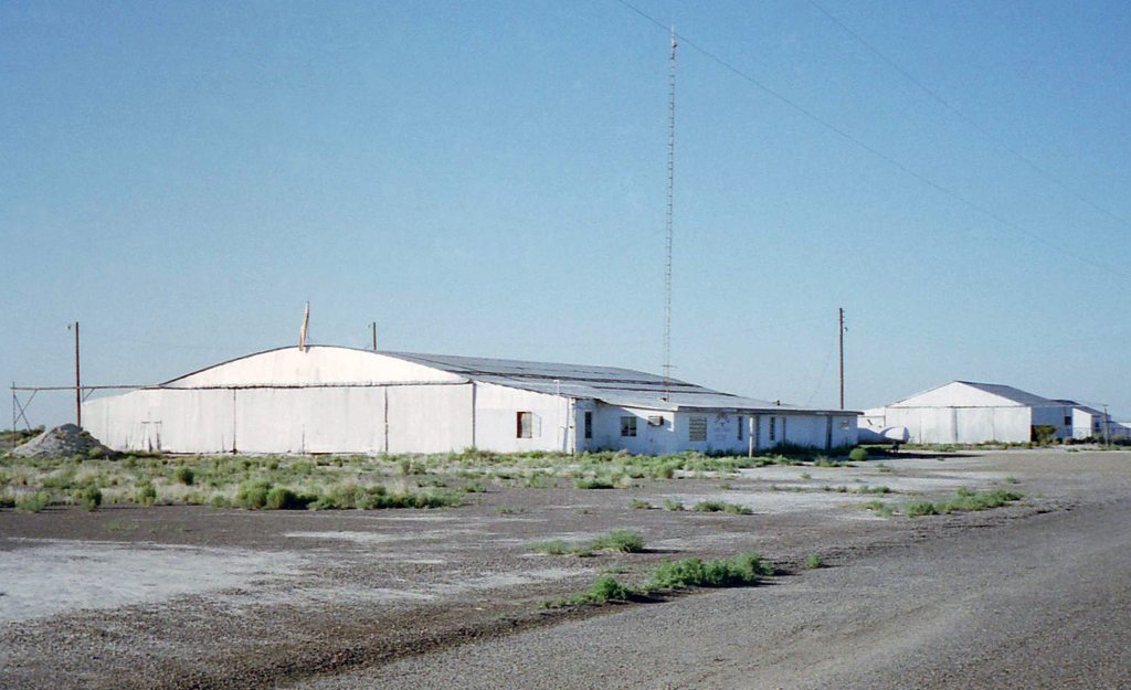
A 6/17/97 photo by Scott Murdock looking southeast at the Worsham Field hangars.
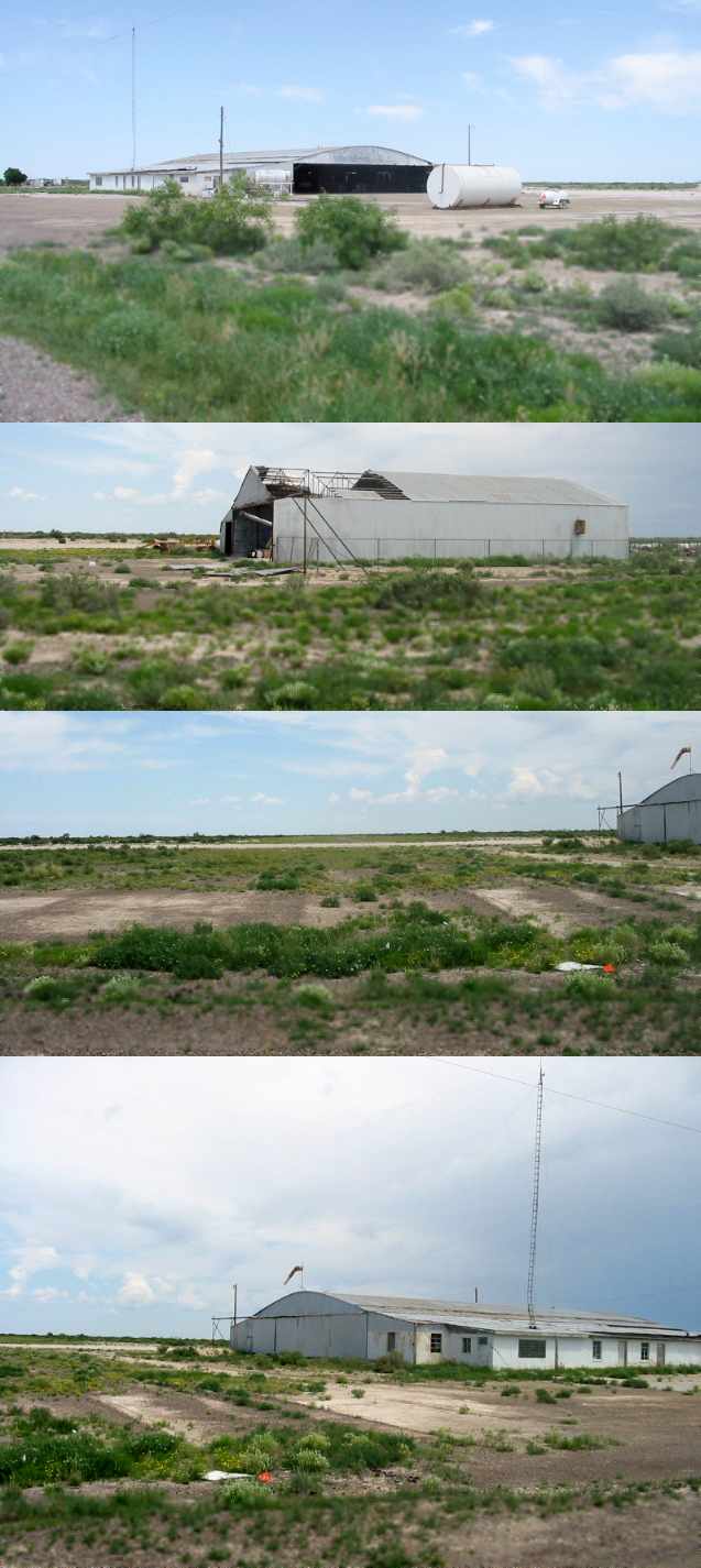
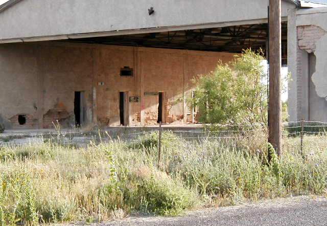
A series of 2007 photos by Cole Perkins of the hangars at the site of Worsham Field.
Cole reported, “The runway that runs north to south has been maintained (graded dirt strip),
but the one that runs east west is still visible, but apparently is not used anymore.
The windsock had 'Agricultural' printed on it. It looks like it is used by a crop dusting service, but no planes were visible.”
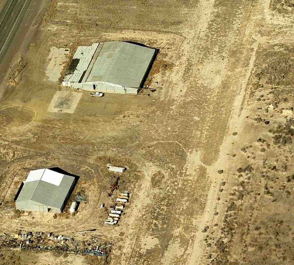
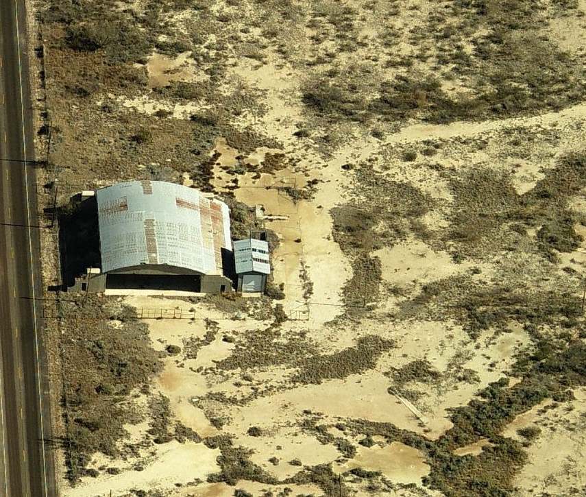
A circa 2010 aerial view looking north at the hangars & runway remains at at the site of Worsham Field.

A 2015 aerial view looking northwest at the hangars & runway remains at at the site of Worsham Field.
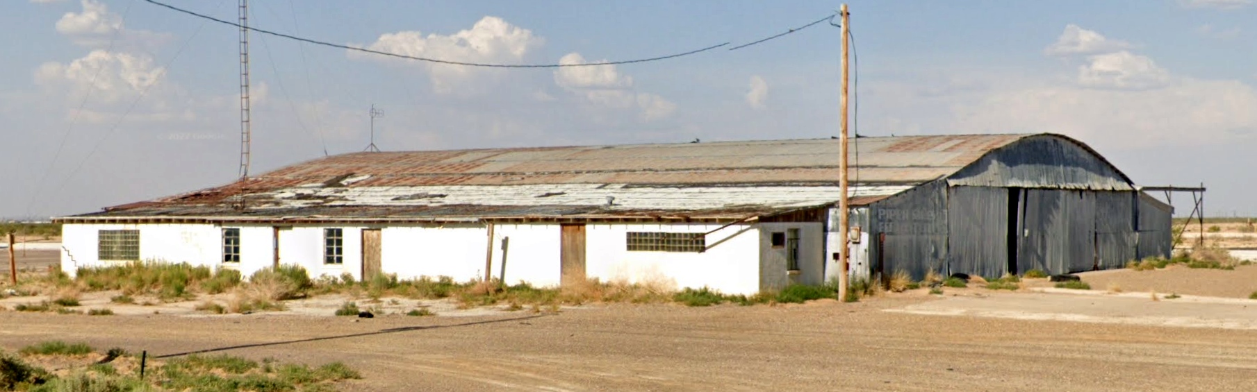
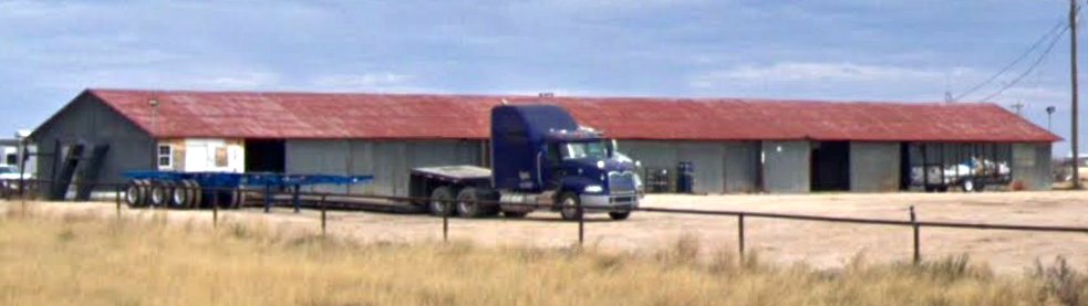
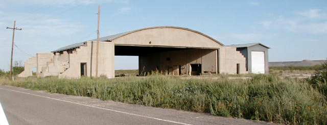
A 2022 photo looking east at larger remaining Worsham Field hangar, which has “Piper Sales” still visible to the left of the hangar door.
____________________________________________________
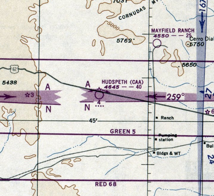
Hudspeth Intermediate Field, Hudspeth, TX
31.8, -105.63 (East of El Paso, TX)
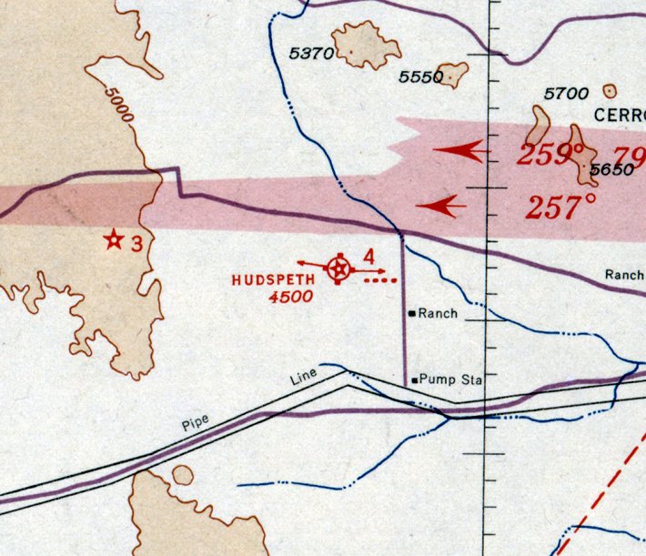
Hudspeth Intermediate Field, as depicted on the August 1935 El Paso Sectional Chart.
This field was one of the network of Intermediate Fields which were constructed in the 1930s by the Department of Commerce,
for emergency use of commercial aircraft along Airways between major cities.
The date of construction of the Hudspeth Intermediate Field has not been determined.
The earliest reference to the field which has been located
was in the 1934 Department of Commerce Airfield Directory (according to Chris Kennedy).
It described the Hudspeth field as having 2 sand runways in an "L" shape, with the longest being the 3,960' east/west runway.
The earliest depiction which has been located of the Hudspeth Intermediate Field was on the August 1935 El Paso Sectional Chart,
which depicted it as Commerce Department Site #4.
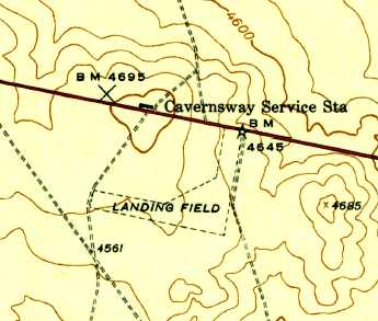
The 1943 USGS topo map depicted Hudspeth Intermediate Field as 2 unpaved perpendicular runways, labeled as “Landing Field”.
The last aeronautical chart depiction which has been located of Hudspeth Intermediate Field was on the February 1950 El Paso Sectional Chart.
It depicted the "Hudspeth (CAA)" airfield as being Site 4 along the El Paso - Fort Worth Airway, and having a 4,000' unpaved runway.
Hudspeth Intermediate Field was evidently closed at some point between 1950-51
as it was no longer depicted on the March 1951 El Paso Sectional Chart.
The Hudspeth airfield was not depicted at all on USGS topo maps from 1975, 1979, or 1985.
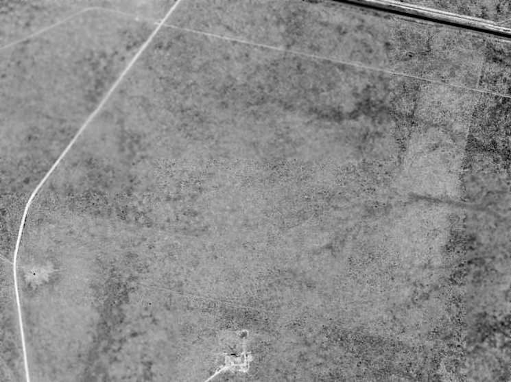
In the 1996 USGS aerial photo, the outline of the 2 runways at Hudspeth were still barely recognizable:
one running east/west along the south end of the field, and another running north/south along the east side.
There were no remaining signs of any former airfield buildings at the site.
![]()
Two 2006 photos by Clifford Bossie of remains at the site of the Hudspeth Intermediate Field.
The top picture shows the remains of the air route arrow,
and the bottom picture shows the concrete base for the beacon or generator shack.
Clifford reported, “I passed by the Hudspeth Intermediate Field today.
I was on the lookout for the field & found it easily
as I could see the concrete base for the beacon, generator shack & the air route arrow from the highway.
The arrow points East along the airway.
The foundations are only about thirty feet south of US 62/180, but are just inside a fence line.
The airfield itself lies on private property & as I did not have permission to enter I was unable to walk the perimeter.
However, it is laid out in a similar manner to Mt Riley Intermediate,
but unlike Mt. Riley it does not appear that there are any boundary markers still in place.
There were a few pieces of angle iron around the foundation that might be remnants of the beacon tower.
The runways are hard to distinguish from the ground,
but the north/south runway runs up towards the highway & can be seen as a slight variation in the density of vegetation.
It is more noticeable if viewed from the air.”
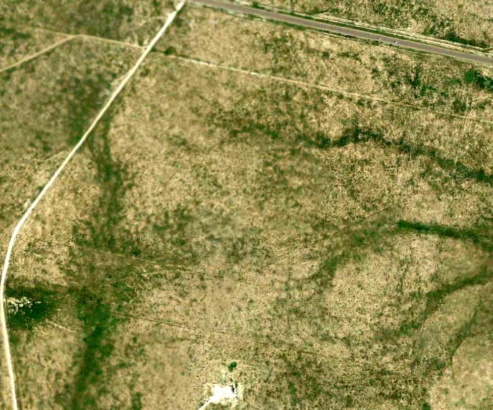
In a 4/1/08 aerial photo, the outline of the 2 runways at Hudspeth were still barely recognizable.
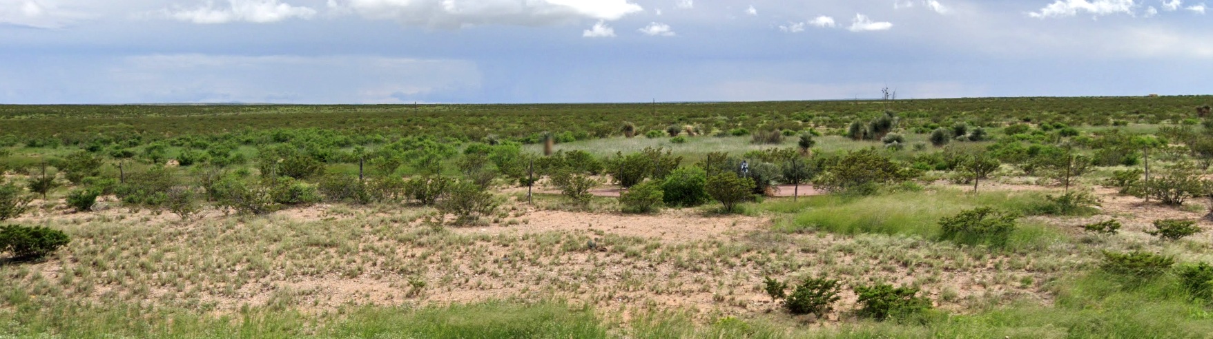
A 2022 photo looking south at the fenced-off remains of the Hudspeth air route arrow, with the site of the Hudspeth Intermediate Field in the background.
The site of the Hudspeth Intermediate Field is located along the south side of Route 62, 10 miles west of Cornudas, TX.
____________________________________________________
Delaware Springs Intermediate Field, Salt Flat, TX
31.856, -104.544 (East of El Paso, TX)
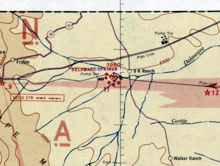
Delaware Springs Intermediate Field, as depicted on the August 1935 El Paso Sectional Chart.
This field was one of the network of Intermediate Fields which were constructed in the 1930s by the Department of Commerce,
for emergency use of commercial aircraft along Airways between major cities.
The date of construction of the Delaware Springs Intermediate Field has not been determined.
The earliest reference which has been located of Delaware Springs Intermediate Field
was in the 1934 Department of Commerce Airfield Directory (according to Chris Kennedy).
It described the Delaware Springs field as having 2 dirt runways in a cross shape,
with the longest being the 3,960' northeast/southwest runway.
The earliest depiction which has been located of Delaware Springs Intermediate Field was on the August 1935 El Paso Sectional Chart.
It depicted Delaware Springs as being Site 11 along the El Paso - Fort Worth Airway.
The February 1949 El Paso Sectional Chart (courtesy of Chris Kennedy)
depicted the "Delaware Springs (CAA)" airfield as being Site 11 along the El Paso - Fort Worth Airway.
The last aeronautical chart depiction which has been located of Delaware Springs Intermediate Field was on the March 1961 El Paso Sectional Chart.
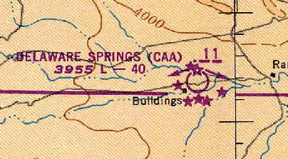
It depicted the "Delaware Springs (FAA)" airfield as having a 3,900' unpaved runway & an airway beacon.
The 1963 TX Airport Directory (courtesy of Steve Cruse) described the Delaware Springs "FAA Site" as having 2 turf runways, with the longest being the 3,900' Runway 5/23.
A single hangar & a pump shed were depicted at the southwest corner of the field.
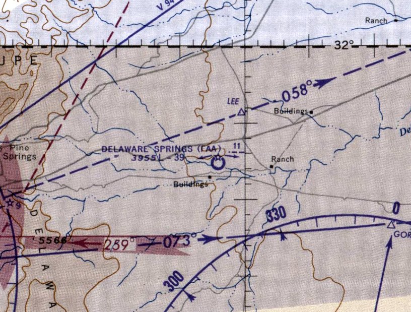
The designation of the Delaware Springs airfield apparently changed at some point between 1949-63,
as it was listed in the 1963 AOPA Airport Directory (according to Chris Kennedy) as "Site 9".
The Delaware Springs airfield was evidently closed by 1965, as it was no longer depicted on the March 1965 El Paso Sectional Chart.
The 1967 TX Airport Directory (courtesy of Brad Stanford) still listed the Delaware Springs airfield as "Site #9".
The 1973 USGS topo map depicted the Delaware Springs airfield, but it was unlabeled.
It also depicted a narrower set of runways, which had apparently been overlaid at some point over the wider original runways.
A 1996 USGS aerial photo showed the outline of Delaware Spring's original 550' wide runways were still barely apparent.
Within these outlines, the more recent, narrower runways were much more distinct. The "pump shed" at the southwest corner of the field appeared to still be standing, but not the hangar.

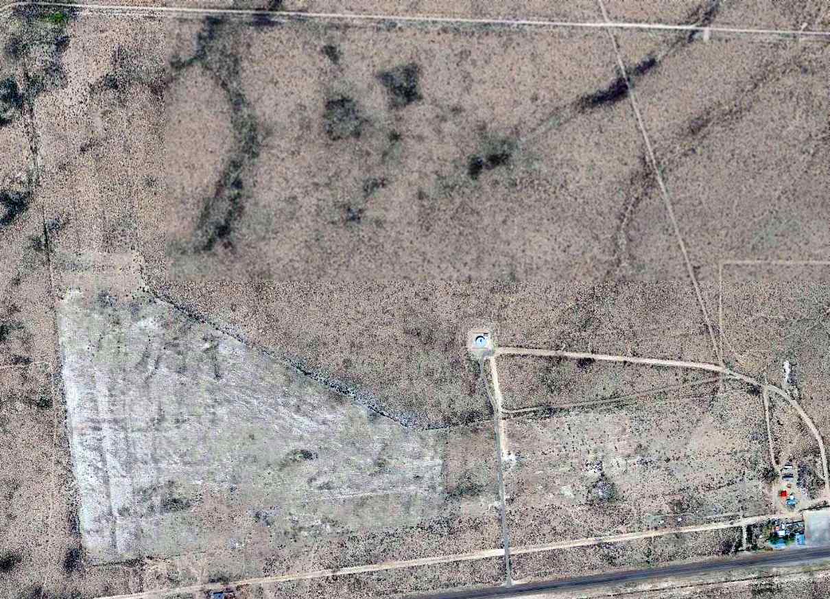
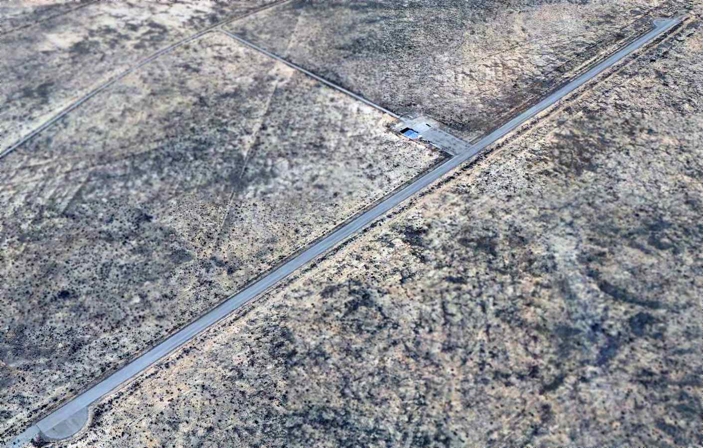
A 2023 aerial photo looking north showed the Delaware Springs runways to remain quite intact.

A 2023 aerial photo of the pump shed, red concrete airway arrow, and hangar foundation at the southwest corner of the Delaware Springs Intermediate Field.
The site of the Delaware Springs Intermediate Field is located 11 miles southeast of Nickel Creek, in an area so remote that the nearby roads are not labeled on maps.
____________________________________________________
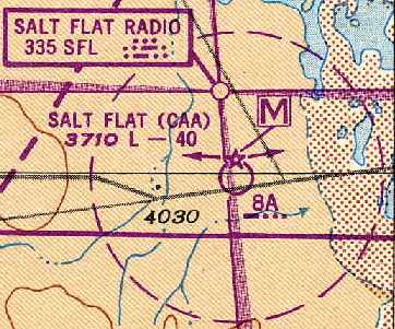
Salt Flat Intermediate Field, Salt Flat, TX
31.75, -105.09 (East of El Paso, TX)
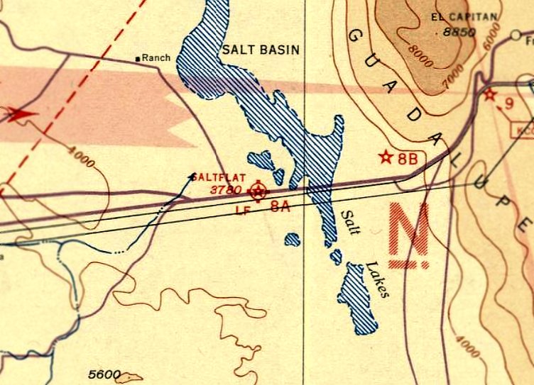
Salt Flat Intermediate Field, as depicted on the August 1935 El Paso Sectional Chart.
Salt Flat Intermediate Field was one of the network of Intermediate Fields which were constructed in the 1930s by the Department of Commerce,
for emergency use of commercial aircraft along Airways between major cities.
According to the Handbook of TX Online, the Salt Flat Intermediate Field was constructed in the early 1930s,
after an American Airlines plane crashed in the nearby Guadalupe Mountains.
The Federal government built the emergency landing strip in Salt Flat
so planes could land when fog enveloped the mountains.
According to TexasEscapes.com, “An early passenger airplane crash in 1932
prompted the government to create an emergency landing field at Salt Flat.
FAA personnel manned the field 24 hours a day.”
The earliest directory reference to the field which has been located
was in the 1934 Department of Commerce Airfield Directory (according to Chris Kennedy).
It described the Salt Flat field as having 3 sandy landing strips forming a "L" shape,
with the longest being the 3,000' north/south runway.
The earliest aeronautical chart depiction which has been located of Salt Flat Intermediate Field was on the August 1935 El Paso Sectional Chart.
It depicted Salt Flat as being Site 8A along the El Paso - Fort Worth Airway.
Mark Casillas recalled, “I knew Floyd & Gertrude Kimzey, who both had spent many years with CAA & FAA.
Floyd & Gertrude Kimzey opened up the Salt Flat station.
Floyd Kimzey was one of the early CAA guys that was assigned to these barren outposts, he & his wife had to rough it out there all by themselves.
They were very good story tellers, as most folks of their generation learned how to do that very well.
I remember them as good friends, and I admired their dedication to serving aviators of all types.”
Jan Tomas recalled, “My father's (Wesley Mosley) contribution to the WWII effort...
He was chief of a CAA station in Salt Flat, Texas, halfway between El Paso & Carlsbad.
I lived there during the war years in government housing with my parents.
Fighter planes landed & took off all day long & sometimes at night during an emergency.
I remember a couple dozen or more parked alongside the runway at times,
their tails about less than half a football field away from out back door.
I was told pilots flew out from El Paso to gather up hours & practice takeoffs & landings before being sent overseas.
It was not uncommon to see tall black smoke plumes from an airplane crash rise high into the sky.
Dad was often called to report & deal with those crashes, many in the Guadalupe Mountains.
He was in his mid-30s, and in charge of the entire operation from air traffic control to weather observation/prediction.
At one point the doctor ordered him off the job for 6 weeks because he had developed an ulcer, which bothered him all his life.
He also became partially deaf from the radio noise. Those were his war wounds.
My father & his crew of about 4-6 people handled an unbelievable amount of air traffic.
The little shack was where Dad & his crew worked 24/7.”
Jan Thomas recalled, “Salt Flat Airport... I was only 4-5 years old when we lived there,
but I remember lines of fighter planes parked, their tails toward our house (to the left of the airplane strut & out of sight).
'Wes,' my mother asked my dad, 'can you tell those pilots not to whir their propellers before they turn off the motors? That sends dust onto my clean laundry.'
'Yeah, Elsie, I'll do that,' Dad replied with a small smirky smile.”
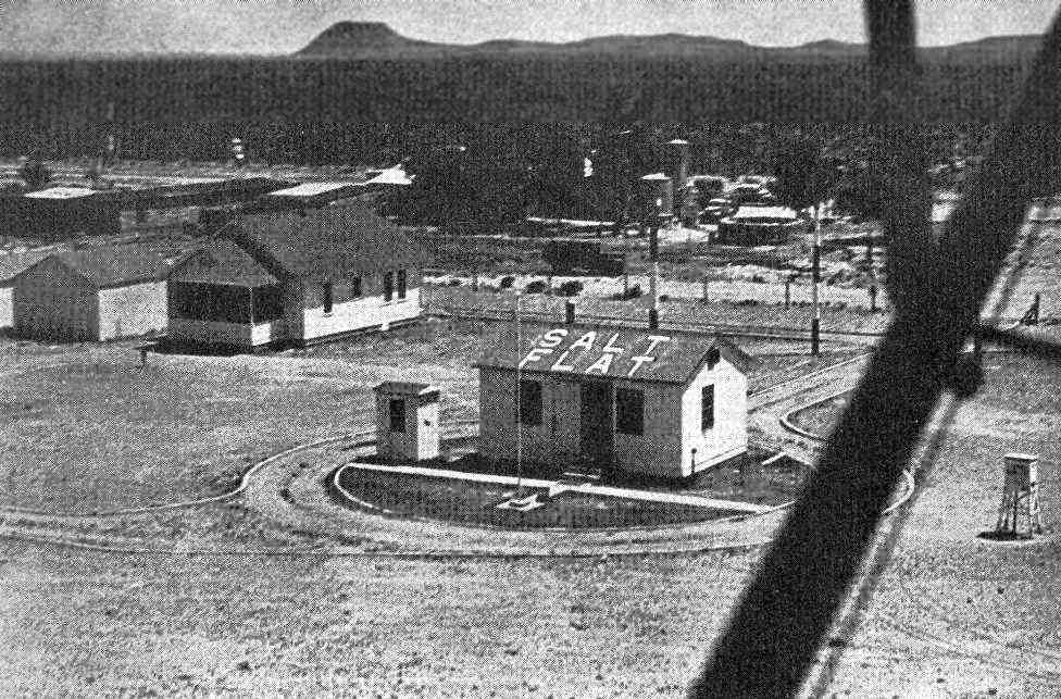
The earliest photo which has been located of Salt Flat Airfield
was an undated aerial view (note the wing strut at right) from a December 1948 magazine article (courtesy of Jerry Sorrell)
of what appeared to be “a weather bureau on the field” at Salt Flat.
The February 1949 El Paso Sectional Chart (courtesy of Chris Kennedy)
depicted the "Salt Flat (CAA)" airfield as being Site 8A along the El Paso - Fort Worth Airway,
and depicted the Salt Flat Radio (a 4-way radio range) as also being located at the field.
David Finnell recalled, “I taught (other) young men to fly from the Salt Flat Intermediate Landing Field.”
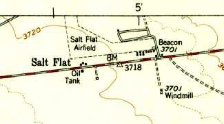
The 1955 USGS topo map depicted “Salt Flat Airfield” as having 2 perpendicular unpaved runways,
and a cluster of small buildings & a beacon along the southeast side.
Weather data was recorded at the “Salt Flat CAA Airport” ending in December 1957 (courtesy of Jerry Sorrell).
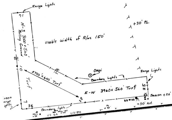
The 1963 TX Airport Directory (courtesy of Steve Cruse) described the Salt Flat "FAA Site"
as having 3 “turf” runways, with the longest being the 3,960' east/west runway.
The Salt Flat airfield apparently closed at some point between 1963-67
(as more reliable aircraft made the more remote intermediate fields unnecessary),
as it was not listed among active airfields in the 1967 TX Airport Directory (courtesy of Brad Stanford).
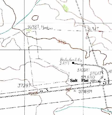
The 1984 USGS topo map depicted the outline of the western portion of the former Salt Flat airfield.
It also depicted the Salt Flat VOR as “Radio Facility”.
In the 1998 USGS aerial photo, the outline of the Salt Flat airfield was still quite distinctive.
The transmitter beacon of the Salt Flat VOR (which had replaced the original Salt Flat Radio 4-way radio range)
was also visible in the center of the photo.
The Salt Flat VOR remained in operation as of 2003.
A 2006 photo by Clifford Bossie of the wooden “X” on the east end of the former Salt Flat runway, which marks it as closed.
Clifford Bossie reported in 2006, “Salt Flats is very noticeable from US 62/180.
The beacon tower used to be visible from the road
and when we would take family trips to Carlsbad Caverns I would always say 'I need to photograph that while it is still there.'
Well I didn't & now it is not there. Live & learn.
Anyway, I drove up the east side of the field & about halfway down the north side.
The entire area is fenced in with barbed wire that was probably put up when the field was operational.
There is a wooden 'X' on the east end of the runway to designate it a closed field.
If there were any buildings on the field itself they are long gone,
but the concrete 'cradles' for the generator fuel tanks are still noticeable on the south side of the field.
There is also a pole supporting the skeleton of a windsock on the west part.
The runways, though visible are choked with growth.”
A 2006 photo by Clifford Bossie of the former windsock skeleton on the western portion of the former Salt Flat airfield.
A circa 2006-2010 aerial view looking north at the remains of the Salt Flat Intermediate Field, with the VOR on the right.
A 2014 aerial photo showed the outline of the Salt Flat airfield was still quite distinctive.
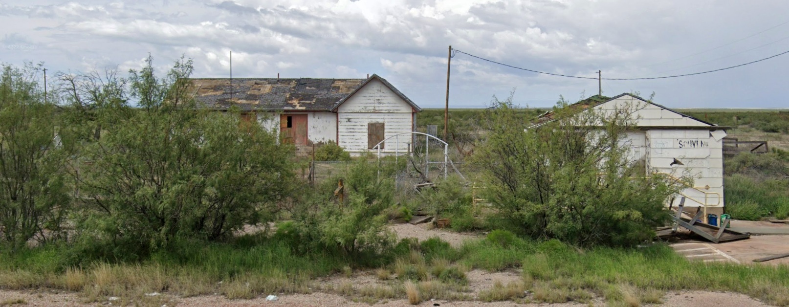
A 2022 photo looking north at buildings which remain on the southwestern side of the Salt Flat airfield site.
The site of the Salt Flat Intermediate Field is located northwest of the intersection of Route 62 & Ranch Road 1576.
____________________________________________________
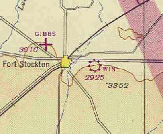
(Original) Fort Stockton Airport / Win Field, Fort Stockton, TX
30.89, -102.83 (East of El Paso, TX)
Fort Stockton Airport, as depicted on the August 1935 El Paso Sectional Chart.
Photo of the airfield while in use has not been located.
The date of construction of the original Fort Stockton Airport (on the east side of town) has not been determined.
The earliest reference to an airfield at this located was in the 1934 Department of Commerce Airfield Directory (according to Chris Kennedy).
It described the "Fort Stockton Airport" as being located
"3 miles due east of Fort Stockton on the south side of the paved highway; one-half mile northeast of cemetery."
It described the airfield as consisting of a 2,800' square gravel & sod field.
The earliest depiction which has been located of Fort Stockton Airport was on the August 1935 El Paso Sectional Chart.
It depicted Fort Stockton as a commercial/municipal airport.
It was still depicted as Fort Stockton Airport on the June 1942 El Paso Sectional Chart.
The original Fort Stockton Airport was reused during WW2 as Win Field.
According to The Handbook of TX Online, Win Field was used during WW2 as an auxiliary field
for the use of Gibbs Field (which became the present-day Fort Stockton Airport).
The Pacific Air School conducted primary flight training under contract to the military at Gibbs Field, using the PT-17 biplane.
Win Field was named for Fort Stockton resident H. L. Winfield.
The date of activation of Win Field is unknown, but the contractor flight school at Gibbs Field itself was in operation from 1942-44.
The January 1944 El Paso Sectional Chart depicted Win Field as an auxiliary airfield.
According to John Voss, the "USN/USAAF Directory of Airfields 1944" described Win Field as being 3.5 miles east of the town of Fort Stockton,
adjacent to US 290, and having a 5,400' sod runway.
The June 1944 El Paso Sectional Chart (courtesy of Chris Kennedy) depicted Win Field as a commercial/municipal airport.
"Win" was depicted on the 1949 El Paso Sectional Chart (according to Chris Kennedy) as having a 5,400' unpaved runway.
Win Field was not depicted at all on the 1954 USGS topo map.
The earliest photo which has been located of Win Field was a 5/27/54 USGS aerial view.
It depicted Win Field as having 4 unpaved runways, with a hangar on the north side.
The last aeronautical chart depiction which has been located of Win Field was on the March 1956 El Paso Sectional Chart.
It depicted Win as a private field with a 5,400' unpaved runway.
Win Field was no longer depicted on the September 1956 El Paso Sectional Chart.
Butler Tyler recalled, “Airfield at Fort Stockton... I lived at the hangar location from 1961-66 during my high school years.
The hangar & land was in operation as a dynamite supplier to seismographers all over TX & NM.
My Dad drove a delivery truck to them & we lived in a trailer house out at the site doubling as night watchman.
The long caliche road away from the hangar ended at a series of truck trailers the held the dynamite sticks & blasting caps.
The road back to the magazine trailers was one of the runways.
Davenport Body Shop had an aerial photograph of 7D Farms that included the airfield & you could see the runways plain on it. ”
No airfield at all was depicted at the location on USGS topo maps from 1970, 1973, or 1982.
Wendy Jenigen recalled, “I lived at Win Field from about 1981-85.
The dynamite company when I lived there was Strawn Explosives out of Dallas TX.
When Tony Steneck & I moved in out there the local sheriff stopped by & told us if we ever had any trouble just shoot them
and pull them inside the house then call him because by the time he got there we would be dead.
Also Tony & another worker were in the old hangar one day & a truckload of about 6 guys came in causing trouble.
The guys did not have a gun in the hangar so I got my shotgun out & fired 2 rounds over their heads!
You should have seen how fast they took off out of there!! We left a loaded shotgun hidden in the hangar after that.”
Wendy continued, “One of those years the Goodyear Blimp landed there by mistake thinking it was the new airport in Fort Stockton as Win Field was still on the map.
They told me the new one was not on their map. So lucky me I got a ride in the blimp across town to the new airport!”
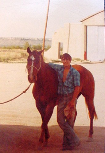
A 1982 photo by Wendy Jenigen of Tony Steneck & her horse Streak, with the former Win Field hangar in the background with the doors still on it.
The 1996 USGS aerial photo showed that the presumed hangar was located on the north end
of what was still a clearly defined 2,700' square parcel.
A straight path leads away from the hangar toward the southeast, but there were no other signs of any former runways.
A series of 2003 photos by Richard Lindsey of the remains of a hangar at Win Field.
The remains of a hangar at Win Field were photographed by Richard Lindsey in 2003.
He found it along the south side of the service road on the south side of Interstate 10
at about mile marker 262-263, which is just east of Fort Stockton.
"A casual inquiry at a gas station gave me little info other than there used to be a training field there. There don't appear to be any runways.
I was also told a story of how you could go out in some of the fields & find '50 cal' shells on the ground
That would seem unusual, if Win Field was a contractor-operated primary flight school, operating unarmed biplanes.”
Lindsey described the site: "The building itself is impossible to miss if you're traveling on I-10,
since there's hardly anything else to look at in the immediate area.
It sure looks like it could have been a hangar, although I haven't been any closer than the roadside.
There appear to be pockets for rolling doors, although the doors are gone. I didn't look to see if there are floor tracks.
There is a much newer metal shed built right next to it that might have taken over whatever duty the old building once had.
There were no obvious signs of a ramp or runway,
though I suppose that they might now be under the service road or interstate."
Richard Lindsey provided further details about Win Field in 2004.
"On my last trip past, I found out that the Pecos County Shooting Range is located adjacent to the old hangar.
That is the straight-line structure positioned a few hundred yards southwest of the hangar.
While these are along I-10, they are actually on County Road 3386. There is no historical marker or anything like that to mark the spot."
A circa 2010 aerial view looking east at the remains of the Win Field hangar.
A 2012 photo looking southwest at the remains of the Win Field hangar.
Art Netteler reported in 2022, “Win Field... My wife & I tried to buy this hangar & 6 acres from the rancher.
They were not interested in any activity to save & restore this beautiful hangar. We pass that hangar monthly. We tried.”
____________________________________________________
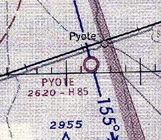
Pyote Army Airfield / Pyote AFB / Pyote Airfield, Pyote, TX
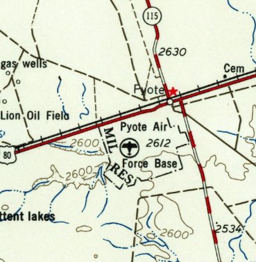
31.5, -103.15 (East of El Paso, TX)
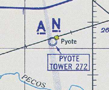
Pyote AAF, as depicted on the February 1943 15M Regional Aeronautical Chart (courtesy of Chris Kennedy).
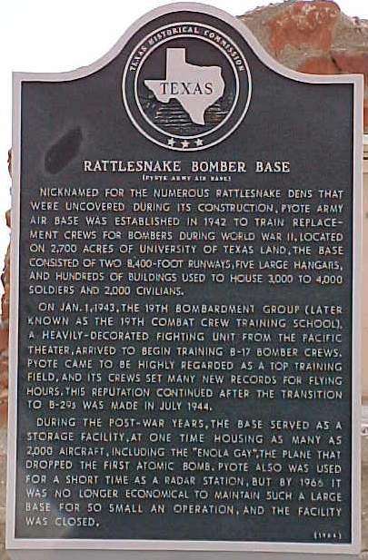
Nicknamed "Rattlesnake Bomber Base" for the numerous rattlesnake dens that were uncovered during its construction,
Pyote Army Air Base was established in 1942 to train replacement crews for bombers during WW2.
It was located on 2,745 acres of University of Texas land.
Pyote AAF was not yet depicted on the June 1942 El Paso Sectional Chart.
The earliest depiction which has been located of Pyote AAF was on the February 1943 15M Regional Aeronautical Chart (courtesy of Chris Kennedy).
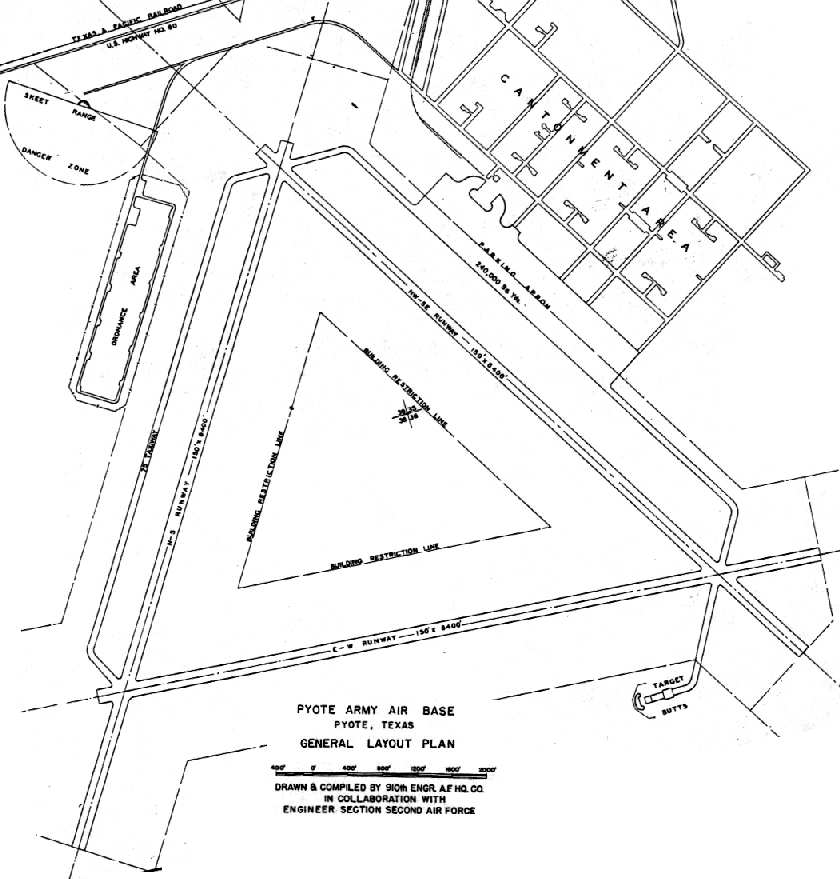
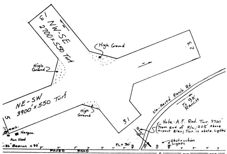
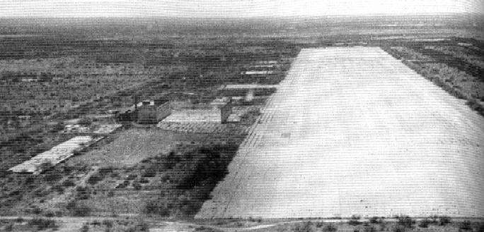
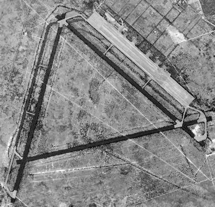
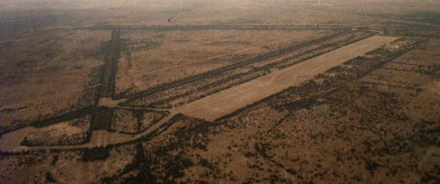
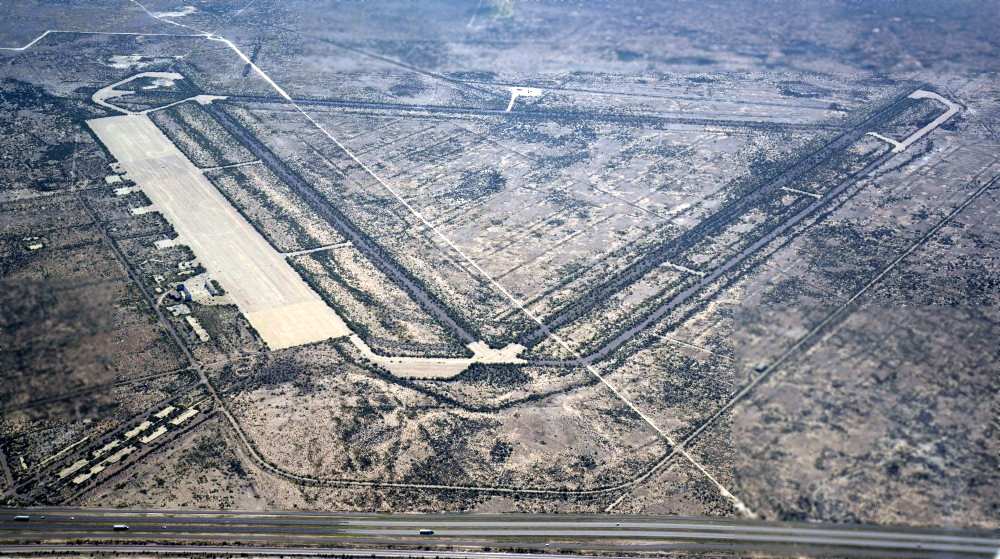
The Pyote airfield was massive: as depicted on a 1943 2nd Air Force General Layout Plan (courtesy of John Voss),
it consisted of three 8,400' paved runways, taxiways, a concrete ramp measuring 3,000' x 600', and 5 large hangars.
The earliest photo which has been located of Pyote AAF was a 5/20/43 aerial view
looking east at the massive complex of temporary buildings on the east side of the airfield, with the runways visible at top-left.
Only 1 hangar appeared to have been constructed at this point.
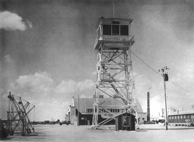
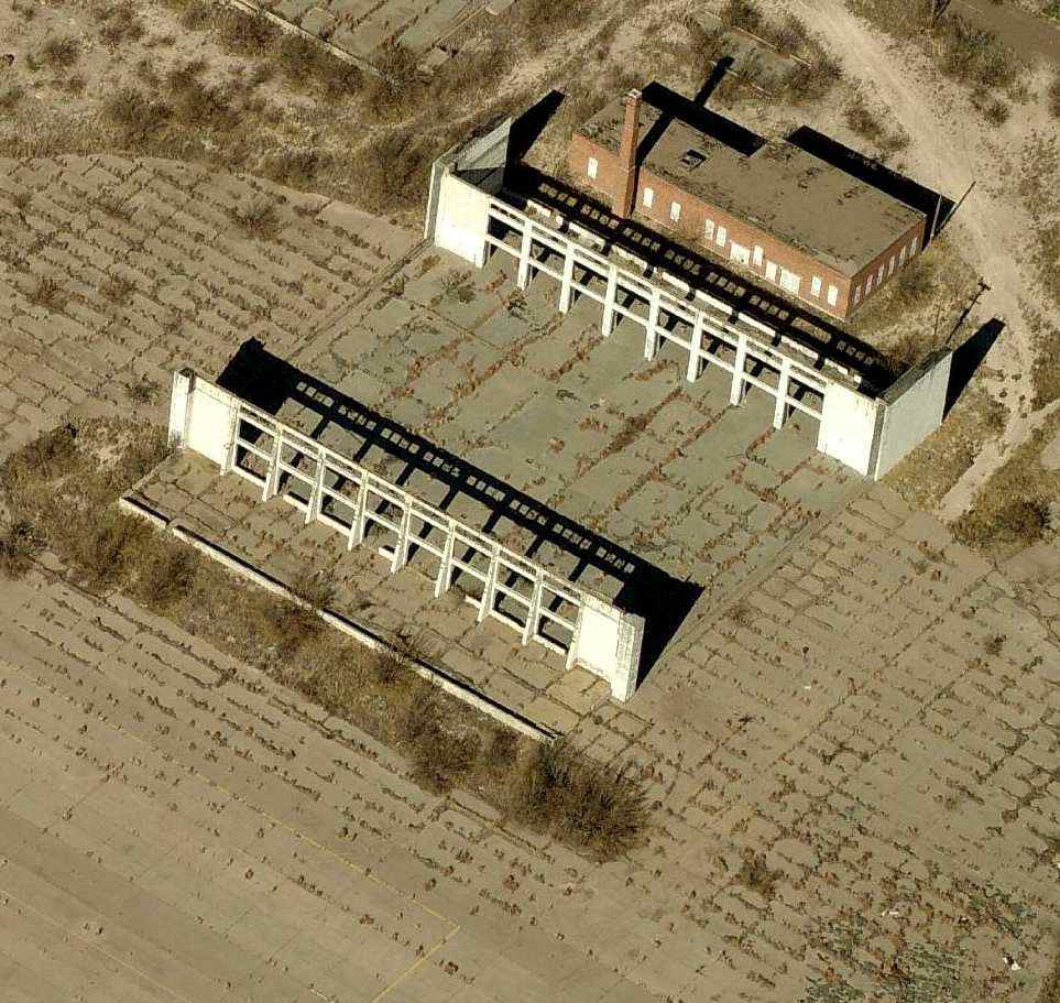
A circa 1943 photo of the Pyote AAF control tower & hangars (courtesy of Cole Perkins).
In 1943, the 19th Bombardment Group arrived to begin training B-17 bomber crews.
Within 4 months of its opening, the base had become the largest bomber installation in the country,
with a peak population of over 6,500 in 1944.
Pyote came to be highly regarded as a top training field,
and its crews set many new records for flying hours.
This reputation continued after the transition to B-29s was made in 1944.
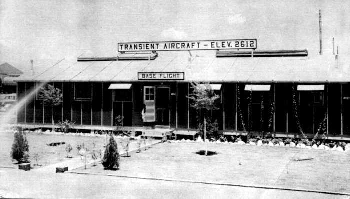
A circa 1943 photo of the Pyote flight operations building (courtesy of Cole Perkins).
Pyote's airfield was further expanded at some point later in WW2, bringing the runways to their ultimate length of 9,000',
and extending the ramp area to more than a mile long.
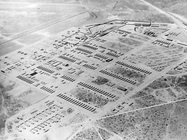
A cantonment area to the northeast of the ramp had a street grid with hundreds of buildings,
used to house 3,000-4,000 soldiers & 2,000 civilians.
A circa 1940s aerial view of Pyote AAF.
A circa 1940s aerial view of Pyote AAF.
The Pyote Ground Gunnery Range was located 4 miles northwest of the airfield,
and consisted of an additional 13,120 acres.
It had various targets, such as an aircraft carrier, bridgehead, convoys, etc.
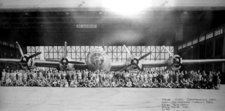
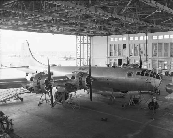
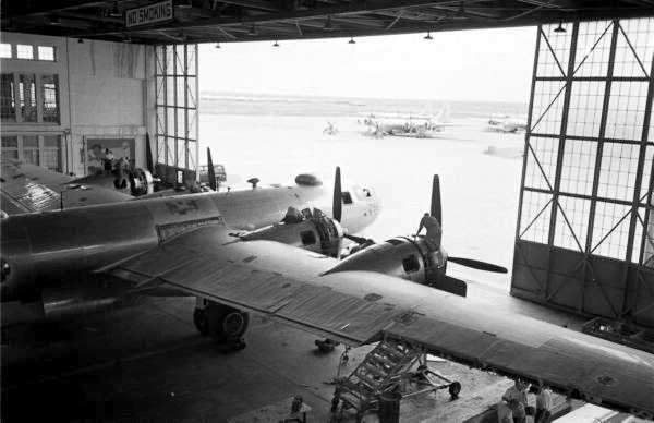
A May 1945 photo of a Sub-Depot maintenance crew in front of a B-29 at a Pyote hangar.
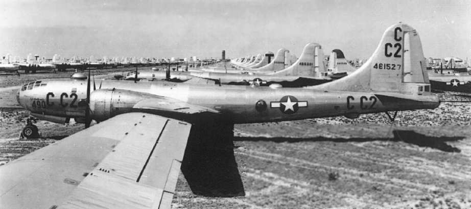
During the post-war years, the base served as a storage facility,
at one time housing as many as 2,000 aircraft (B-29, B-17, B-25, A-26, C-47, P-63, P-51, AT-7, L-5, L-4),
including the "Enola Gay", the plane that dropped the first atomic bomb.
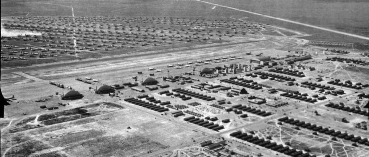
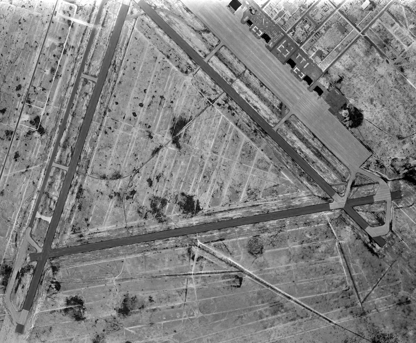
An amazing 11/26/45 aerial view looking west at hundreds of military surplus aircraft in storage at Pyote (courtesy of Rex Ricks).
Five arch-roof hangars were visible along the huge paved ramp.
David McNeely recalled, “Pyote Army Airfield... From 1945-52 my father worked there as a mechanic on B-29s, many of which were stored there, and some of which were reactivated for a time.
I remember visiting the base on a number of occasions, and at an employee family Christmas party climbing into the cockpit of the *Enola Gay*.
Years later my wife & I were on a boat trip along the Maine Coast with 8 passengers. One very distinguished, tall, elderly gentleman was quite loquacious.
He mentioned having retired from the Air Force as a general, and having been the base commander at Pyote Army Airfield for a time after WW2.
I was quite surprised by this. He related that the base had been called 'Rattlesnake Field' & 'Rattlesnake Bomber Base'.
He also stated that he had actually had little to do as base commander, and spent a lot of his time just out flying around the West Texas deserts in bombers.
He also related that he believed he was assigned that command in such a desolate, isolated location to keep him 'out of trouble'.
The field was referred to by many locals as a 'pickling plant', because it stored surplus aircraft.
We believed the location was chosen because it was believed that the desert environment would preserve the machinery better than in another climate.
As a child I was fascinated by the seemingly endless rows of parked planes.”
A 1946 photo of huge numbers of B-29 bombers in storage at Pyote AAF
(courtesy of Lou Thole, author of the book "Forgotten Fields of America").
Pyote AAF was renamed Pyote Air Force Base in 1948,
and continued in use as aircraft storage center under the Air Material Command.
Richard Hawkins recalled, “I grew up in West Texas,
and can vaguely remember seeing hundreds of B-29s stored there in the late 1940s.”
John Henson recalled, “Pyote Airfield was an especially interesting installation for me.
I had a cousin who was stationed there & my parents would take my little brother & me to the main gate to pick him up.
After the war the government flew many planes in & parked them until they could destroy them or sell them.
I remember that there was at least one of every combat aircraft the U.S. had.
I specifically remember B-29, B-17, B-25, B-24, B-26, A-26, P-39,
P-47, AT-6, BT-13,P-51 sitting on the field. The place was packed.
It seems like it took about 2 or 3 years to dispose of all the aircraft stored there.”
The February 1949 El Paso Sectional Chart (courtesy of Chris Kennedy)
depicted Pyote AFB as having an 8,500' hard surface runway.
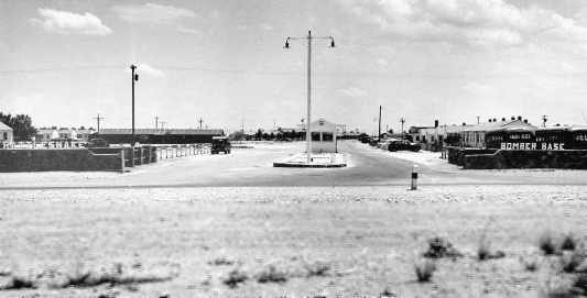
A photo from a 1950 postcard (courtesy of Cole Perkins) of the entrance to the Pyote AFB,
with lettering saying "Rattlesnake Bomber Base" above the entrance walls.
An undated photo of a B-29 bomber inside a Pyote AAF hangar.
The last photo which has been located showing military aircraft at Pyote was a July 1950 photo of B-29s undergoing reactivation.
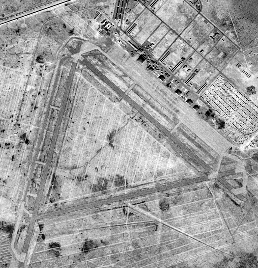
A 12/15/53 USGS aerial view showed Pyote as remaining mostly intact, though appearing abandoned, with none of the runways still painted with active markings.
The hangars remained standing, along with some of the smaller wooden buildings.
Reportedly, Pyote AFB was closed in 1954 & its assets were sold.
Larry Ray recalled, “Pyote... My dad (Civil Service) worked in Salvage.
His job was to get rid of all the aircraft. He was one of the last ones to leave.
He was transferred to Webb in the summer of 1955.”
It was still depicted as Pyote Air Force Base on the 1957 USGS topo map.
"Pyote AFB" continued to be depicted as a military airfield on the March 1958 El Paso Sectional Chart (courtesy of Chris Kennedy).
John Henson recalled, “The base stayed pretty intact through the 1950s.”
For a few years in the 1950s & 1960s, the 697th Aircraft Control & Warning Squadron,
an Air Defense Command unit, operated a radar site on the base.
A 3/15/60 USGS aerial view showed Pyote as remaining mostly intact, though appearing abandoned, with none of the runways still painted with active markings.
The hangars remained standing, but it appeared as if all of the smaller wooden buildings had been removed.
John Henson recalled, “The last active runway shut down when the radar unit was shut down.
It was my understanding the Air Force flew crews in to operate it.
I know it was still active during 1962-64.”
At some point between 1958-62, the former Pyote AFB was reused as a civilian airfield,
as that is how "Pyote" was depicted on the March 1962 El Paso Sectional Chart (courtesy of Chris Kennedy).
The Aerodromes table described "Pyote Airfield" as having 3 runways, with the longest being an 8,520' asphalt strip.
The remarks said "Formerly AFB. No opers."
During its period of reuse as a civilian airfield,
Pyote may also have been used by the flying museum group the Confederate Air Force.
Nancy Cagle recalled, “I always remember the old 'Confederate Air Force' sign that was also over an old entrance quite near I-20.
I think the old CAF couldn't hold onto it since Pyote is truly 'out in the middle of nowhere'.”
However, this civilian reuse of the Pyote airfield apparently did not last long,
as by the time of the August 1964 El Paso Sectional Chart (courtesy of Chris Kennedy),
it was depicted as "Abandoned airport".
Following the deactivation of the Pyote radar site in 1966, base housing was taken over by the West Texas Children's Home,
and the land & remaining buildings reverted to the University of Texas.
A 1967 aerial photo showed 6 hangars on Pyote's northeast ramp.
Strangely the 1971 USGS topo map did not depict any of the massive former Pyote runways,
even though the hangars & smaller buildings were depicted, labeled “West TX Childrens Home”.
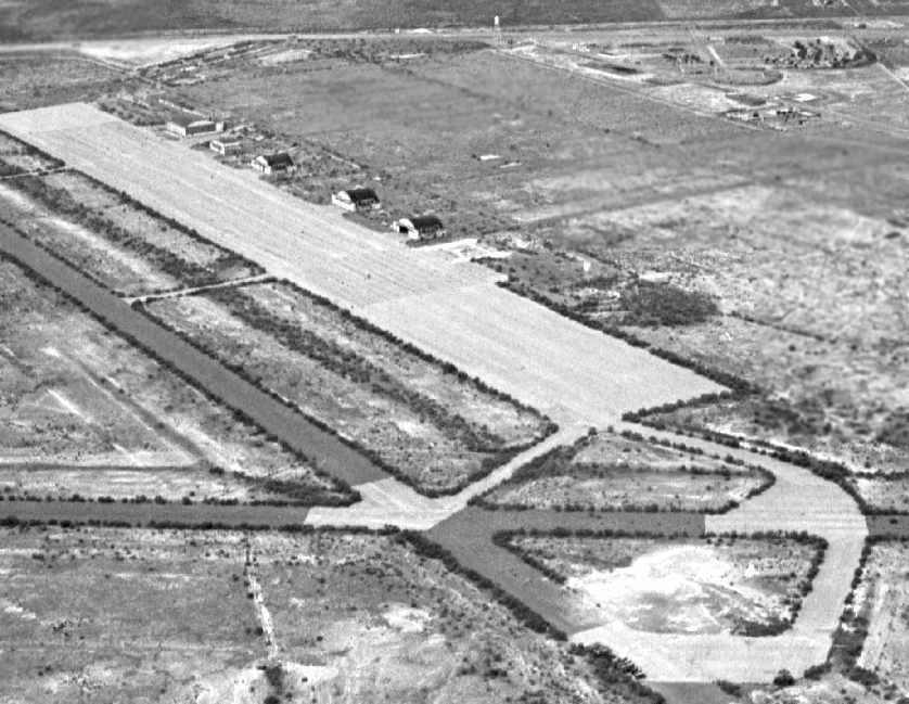
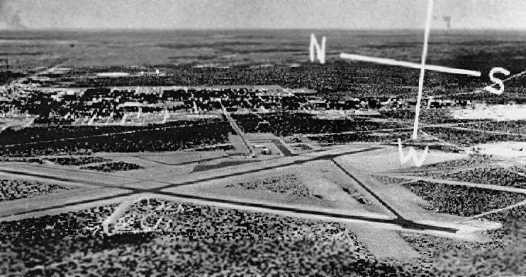
A 1977 aerial view by Richard Hawkins looking north at the Pyote ramp.
Only 5 hangars remained standing – the nearest hangar had evidently been removed at some point between 1967-77.
A 1977 photo by Richard Hawkins of the former 3rd Echelon Maintenance Hangar.
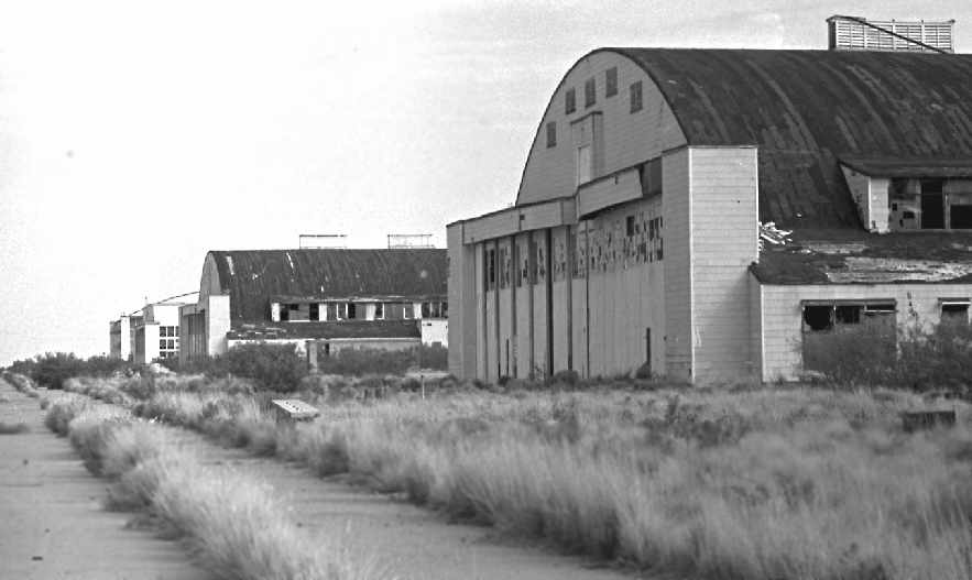
A 1977 photo by Richard Hawkins looking northwest along the 4 of the 5 hangars which remained standing at the time.
Note the height of the weeds growing up through the concrete.
At some point between 1977 (when the above pictures were taken) & 1980,
four out of the 5 remaining hangars were apparently removed/destroyed.
At least one of them was evidently intentionally destroyed in the course of filming the 1980 movie “Hangar 18”.
Nancy Cagle described “the 'real' end of the base.
I do know how the last buildings were destroyed.
[In] the movie 'Hangar 18'... At the end you will see Pyote 'blown off the map'.
We'd been past it so many times, we knew what we were seeing!
All 4 of us recognized it immediately.”
John Henson recalled, “Most of the hangars were torn down in the late 1970s / early 1980s I think.
One hangar was left standing & that was because the government & the Confederate Air Force
made a deal so that the CAF could store parts in it for their aircraft.
That deal apparently was canceled some time after the Japanese complained
about the Pearl Harbor attack re-enactment & Hiroshima bomb re-enactment performed during the air shows.”
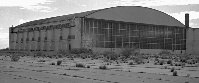
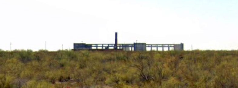
By 1985 a single large hangar (the former 3rd Echelon Maintenance Hangar)
and slowly deteriorating runways & taxiways were all that marked the once-busy bomber base.

An undated photo of model aircraft & several aircraft wrecks used in the 1985 movie “Fandango”,
with Pyote's hangar in the background, painted with “Pecos Parachute School”.
The film crew was on-site for 2 months to prepare the site & do the filming.
According to Clifford Kidd, “It was mislabeled for screen purposes as being in Pecos.
If you watch the film you can see much of the old hangar inside & out, along with the ramp & surrounding area.”
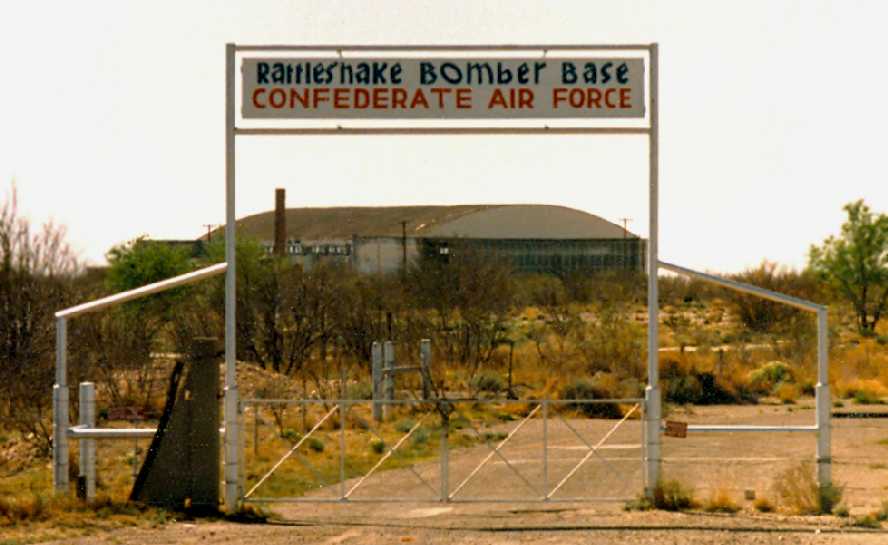
A March 1986 photo by Zane Adams of the CAF sign, with the Pyote hangar in the background.
MK recalled, "The hangar was intact when I rolled through in May 1989."
John Ragozzino recalled, In “1991 I flew my Stinson 108-1 to Pyote Army Airfield, landed on the ramp,
and camped overnight by the remaining hangar structure. Had a great time.”
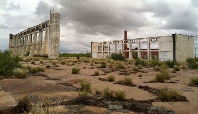
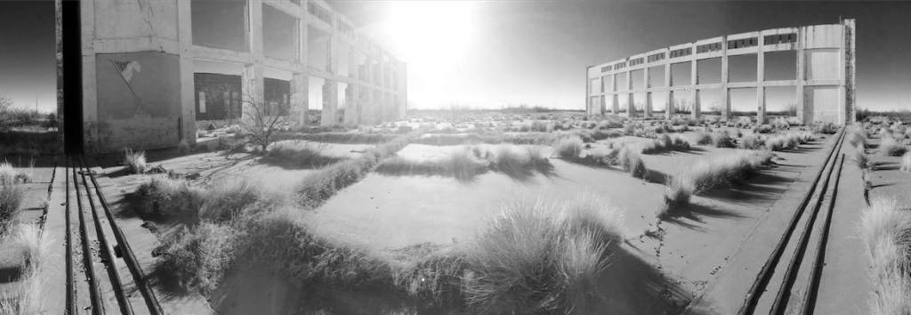
At some point between 1989-96, the roof & most of the walls of the former 3rd Echelon Maintenance Hangar were removed,
leaving only a hollow grid of the side walls of the hangar standing.
Cole Perkins recalled, “The final hangars... They were dismantled & sold for scrap.
My grandfather bought some of the lumber out of one of the old hangars
and we built a screened-in porch on the back of his house in Monahans.
I can remember trying to drive nails in the 1"x4" decking & it would bend the nails.
I learned quickly to predrill a hole to nail the boards.
Also, the wood was a true 1" by 4" not the standardized lumber (3/4" by 3 1/2") that we have today
and it was all 'heart' pine from our virgin forest.”
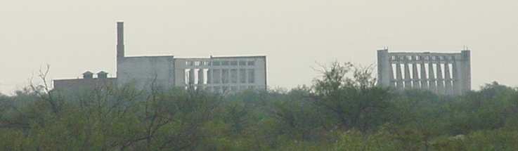
A circa 1990s aerial view looking southeast at the remains of the Pyote ramp, with hangar remains visible to the left of the ramp.
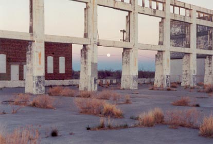
A circa 1990s view by Gary Waters of the remains of the last remaining hangar at Pyote, the 3rd Echelon Maintenance Hangar.
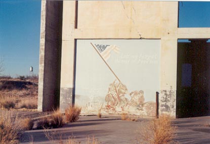
A circa 1990s view by Gary Waters of a mural on the wall of the 3rd Echelon Maintenance Hangar.
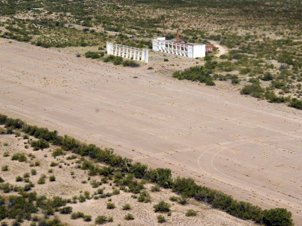
"Rattlesnake Bomber Base" historical marker on the north side of Interstate 20.
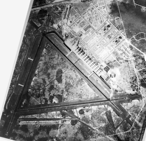
USGS aerial photo 1996.
The airfield at Pyote was still depicted as an abandoned airfield on 1990s aeronautical charts,
but was not depicted at all on recent USGS topo maps.
A 1997 aerial view by Lou Thole (author of the book "Forgotten Fields of America")
looking south at the remains of the Pyote runways.
A 1997 photo by Lou Thole (author of the book "Forgotten Fields of America")
looking northeast at the remains of the last remaining hangar at Pyote, the 3rd Echelon Maintenance Hangar.
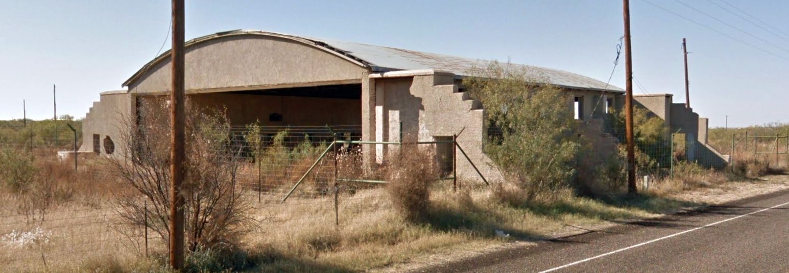
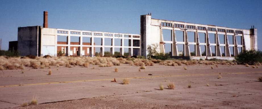
The walls of the former 3rd Echelon Maintenance Hangar were still standing in 2003, as photographed by Scott Murdock.
An October 2004 photo by Tim Tyler of the remains of the last hangar at Pyote,
the former 3rd Echelon Maintenance Hangar.
Tim Tyler visited the site of Pyote AAF in October 2004.
He found the property to be used by the "Texas Youth Commission’s West Texas State School.
Not much activity observed on a mid-afternoon weekday visit.
The former AFS family housing (small, individual units) now looks to be used by prison staff,
but otherwise most buildings seem to be of modern construction.
I didn’t see anything related to the University of Texas.
The west side of the former AAF/AFB, where the actual airfield was, sits apparently unused,
but we couldn’t locate an access road to drive to it & see the partial remains of one of the hangar walls,
which was the only old structure visible."
Nancy Cagle reported in 2005, “The old 'Confederate Air Force' sign that was also over an old entrance quite near I-20...
That disappeared a few years ago.”
Tom Maddux reported in 2008, “I drove past the old base this morning.
The remains of the big hangar are still visible from I-20. Since I didn't know what it was I just kept going.
A few miles down the road at the offramp for Pyote there was a sign that read, 'Pyote Bomber Base Museum'.
I got off the freeway & went into the little town of Pyote.
The lady at the town office was nice enough to call the lady who cares for the museum,
who was nice enough to drive over & open it up for me.
She said you can't get on the old base because it is a 'state school'. It looked like a prison to me as I passed.”
Tom continued, “It turns out that in the 1970s a retired USAF Colonel who had trained there during WWII
brought dozens of photos & artifacts from the old base out to the town.
He got the local folks to adapt an abandoned school building for the museum.
It is nicely done, over 100 photos, old newspapers, uniforms, bits & pieces of WWII equipment & guns,
even a display case built by German prisoners.
The museum is open on Saturday & Sunday. It is definitely worth an hour.”
Clifford Kidd reported in 2008, “The sign at the Pyote base, the Confederate Air Force sign, is in my hangar.
Apparently the previous owner was part of the CAF, he used to have a few scraps of aircraft with nose art or tail art hanging on the walls.
I found it sitting in the rafters not long after I bought the hangar.”
A circa 2010 aerial view looking north at the remains of the last remaining hangar at Pyote, the 3rd Echelon Maintenance Hangar.
A 7/18/13 photo by Jason Henderson of the remains of Pyote's 3rd Echelon Maintenance Hangar.
Jason observed, “It was stormy that day, but I think the clouds make the pics look even better.
As I was walking around the air base I thought of all the history & how many people where there 70 years ago
and I realized how much bigger & more important it was.
It was kinda creepy walking around out there all alone. But it's a moment I'll never forget.”
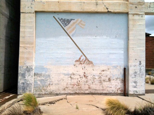
A 7/18/13 photo by Jason Henderson of a mural on the remains of Pyote's 3rd Echelon Maintenance Hangar.
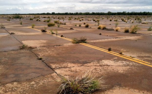
A 7/18/13 photo by Jason Henderson of the remains of Pyote's ramp.
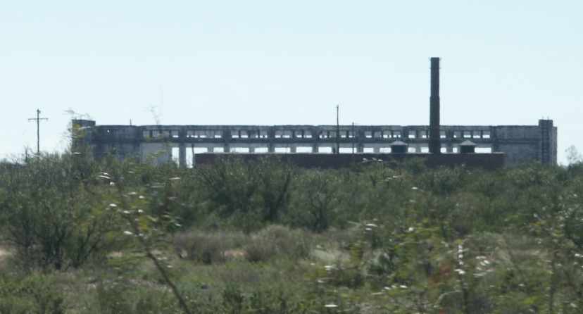
A 10/20/13 aerial view by Scott Greene looking north at the remains of the last remaining hangar at Pyote, the 3rd Echelon Maintenance Hangar.
A 10/20/13 aerial view by Scott Greene looking south at the extensive remains of the Pyote airfield.
A January 2014 photo by Kodi Zene of the remains of the last remaining hangar at Pyote, the 3rd Echelon Maintenance Hangar.
A November 2021 photo looking south at the remains of the last remaining hangar at Pyote, the 3rd Echelon Maintenance Hangar.
_______________________________________________________________________
As of 2015, a Rattlesnake Bomber Base Museum was opened in nearby Monahans (according to John Lane).
Timothy Hahn reported in 2015, “We stopped at the Rattlesnake Bomber Base. Not much has changed.”
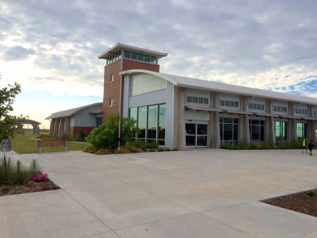
A July 2015 photo by Timothy Hahn of the new $14.5 million Ward County Safety Rest Area.
Timothy reported, “There is a new rest stop on I-20 about 3 miles from the base.
It pays tribute to the base. It is really nice - even the restrooms are aviation themed.”
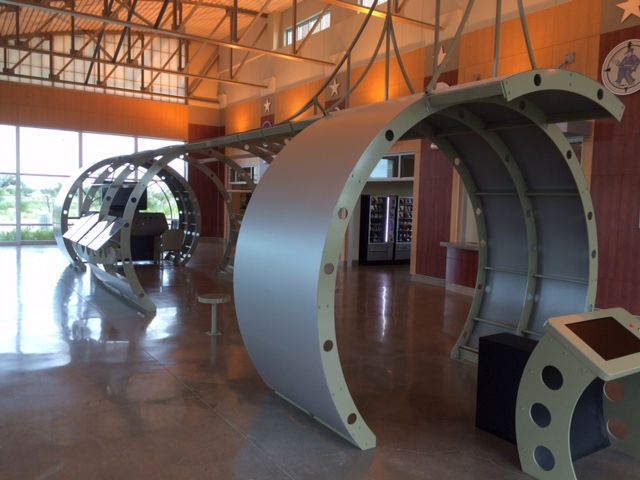
A July 2015 photo by Timothy Hahn of the bomber fuselage display inside the new million Ward County Safety Rest Area.
See also:
A 1994 Army Corps of Engineers Report.
FlyPast magazine, 4/01.
"Forgotten Fields of America", Volume II, Lou Thole, p.103.
http://www.tsha.utexas.edu/handbook/online/articles/view/PP/qbp2.html
____________________________________________________
Milehigh Community Airport (6E2), Sierra Blanca, TX
31.258, -105.297 (Southeast of El Paso, TX)
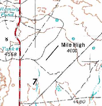
The Milehigh Community Airport, as depicted on the 1975 USGS topo map.
According to A.C. Donnell, this private airport was built to support a desert subdivision.
In Donnell's words, “In the 1970s there was a huge desert subdivision
that some enterprising - and decidedly optimistic - bunch of people built.
The idea was to develop an up-scale retirement community (probably, it is my guess, with a Palm Springs aura in mind).”
The earliest depiction of the Milehigh Airport which has been located was on the 1975 USGS topo map.
It depicted “Mile High” as having a single northeast/southwest runway.
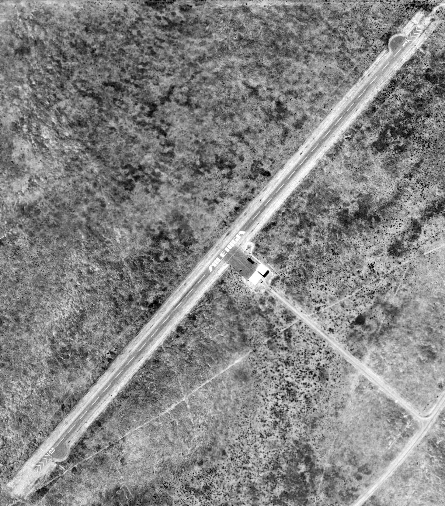
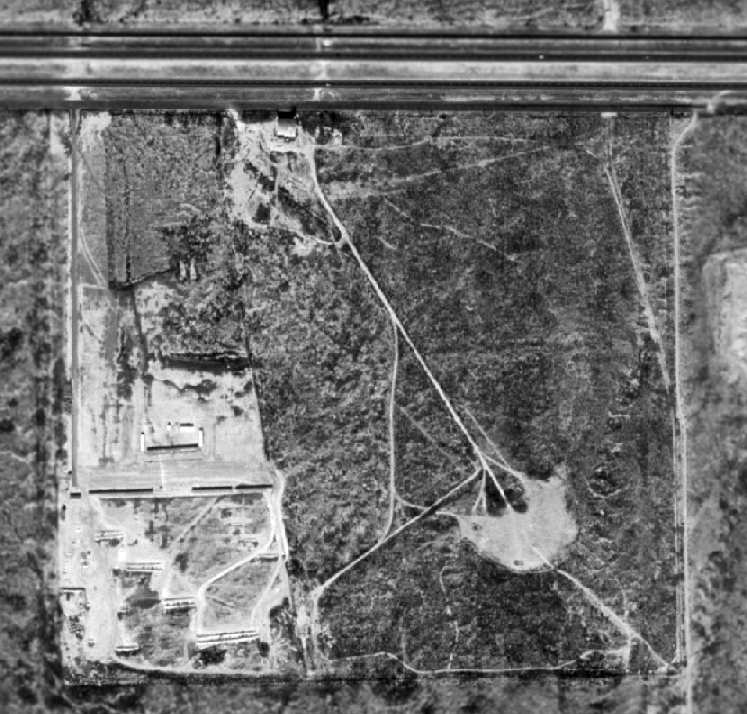
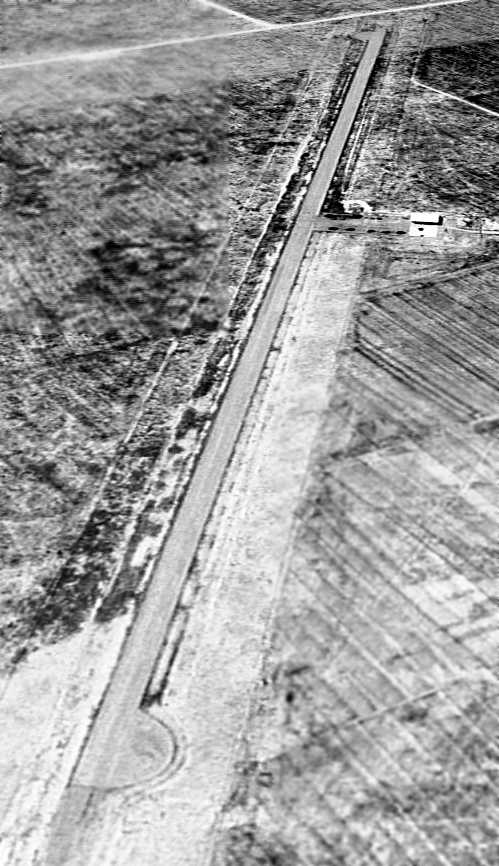
The earliest aerial photo which has been located of Milehigh Community Airport was a 2/9/75 USGS aerial view.
It depicted the field as having a single paved Runway 2/21, on which was painted the airport's name in a groovy font.
A small hangar & paved ramp were on the east side, on which was parked 1 light single-engine plane.
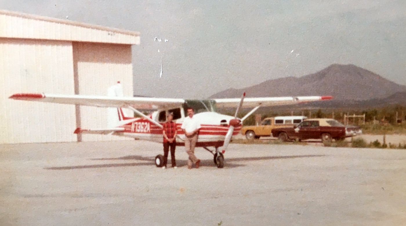
A 6/11/78 photo of flight instructor Holly Ziler & student pilot William Goodman in front of his Cessna 172 (N7362A) on the day he soloed at Milehigh Community Airport.
William recalled, “Holly's maiden name was Lois Hollinsworth, and she was a lady pilot in the military before the famous WASPS were formed.
The Milehigh Community had already gone belly-up by the time that Holly started using the airport to give lessons in her Cessna 152.
I would drive 65 miles to the airport to take my flying lessons.
I was lucky enough to keep my airplane in the hangar that was there, along with her airplane.
It was a big beautiful hangar, with plenty of room for both Holly Ziler's & my airplane.
Off to the right is the mountain named Sierra Blanca, and looking roughly between the hangar & the mountain is the direction that the small town of Sierra Blanca is located.
It is the Hudspeth County seat, and is about 4 miles south of the airport.
It looks like the County Sheriff must have driven Holly up for the big day of my solo flight, as I don't see her car in the photo.”
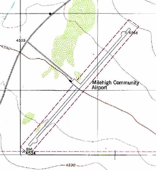
The 1979 USGS topo map depicted the “Milehigh Community Airport” as having a single northwest/southeast paved runway,
along with a small ramp area & a single hangar.
The 1982 AOPA Airport Directory (courtesy of Ed Drury) listed Milehigh Community as a private airfield.
It described the field as having a single 6,100' asphalt Runway 2/20,
and included the note that skydiving activities were reported.
A 1982 aerial view depicted Milehigh Community Airport as having a single northwest/southeast paved runway, along with a small ramp area & a single hangar.
Shawn Matin recalled, “The Mile High Corporation was an effort of the Diamond Head Company to entice the rich & famous to West TX,
where they planned to install a horse racetrack &gambling casino.
It was a nice facility... approximately 7,000' runway; the hangar housed about 8 planes when I was using it. I kept my 172 there.
The only people in Sierra Blanca who had that kind of money were the Border Patrol agents & Highway Patrol stationed there.
Two locals had planes there: Richard Rose (the owner of Michal's Cafe) & Leon Snyder (who ran the local big-rig wrecker service), as well as Holly, and another man also had a 172.
Someone's relative in town came in often in a Citabria, and occasional a Pitts Special, and would hangar there for a week or so, a few times a year.
Holly Ziler managed the airport & hangar, basing her flight school there until the airport closed in the early 1990s.
The Mile High Corporation went bust when the bill to legalize gambling in TX was defeated in Congress.
There were many lots that were sold, most of the housing built to the northeast of Sierra Blanca proper were purchased from Mile High.
When the corporation folded, the Mile High Airport reverted to the land owner, Richard Love. The airport land had only been leased from Love.”
According to A.C. Donnell, “The Mile High development was advertised far & wide, but as far as I know, not a lot was sold.
It was abandoned a few years later.”
Shan Matin observed, “[Aerial] imagery looks like it was being maintained in 1988, but by 1992 it looks to be in disrepair.”
Geroge Horn recalled, “Milehigh Community Airport (6E2)... In the 1990s I flew as a pilot for the State of Texas
and was assigned a King Air 200 flight to 6E2 carrying state employees who were inspecting the area for a planned Waste Disposal Area.
Some huge piles of what was described as 'dried excrement' , garbage and other refuse had been shipped by barge down the East Coast from New York then by train to be stored all around the facility.
As far as could be seen was nothing else but those 15' tall heaps & the single hangar.
The news carried stories that a low-level nuclear waste dump was planned for the area.”
A 1/18/96 USGS aerial photo looking southwest showed Milehigh Community Airport
to have a single paved 7,100' runway, along with a small ramp area & a single hangar.
Milehigh Community Airport was depicted as an abandoned airfield on the 1998 World Aeronautical Chart.
According to A.C. Donnell, “It probably was closed due to non-use & abandonment of the desert subdivision for which it was built.”
Milehigh Community Airport was still depicted as an abandoned airfield on 2002 aeronautical charts.
Shan Matin observed, “Deterioration seems to continue until about 2004, when it looks like it was cleaned up, and the white Xs were removed from the runway.”
A.C. Donnell reported in 2006, “The entry gate/clubhouse can still be seen - deteriorating badly -
just North of the Border Patrol checkpoint a few miles West of Sierra Blanca.”
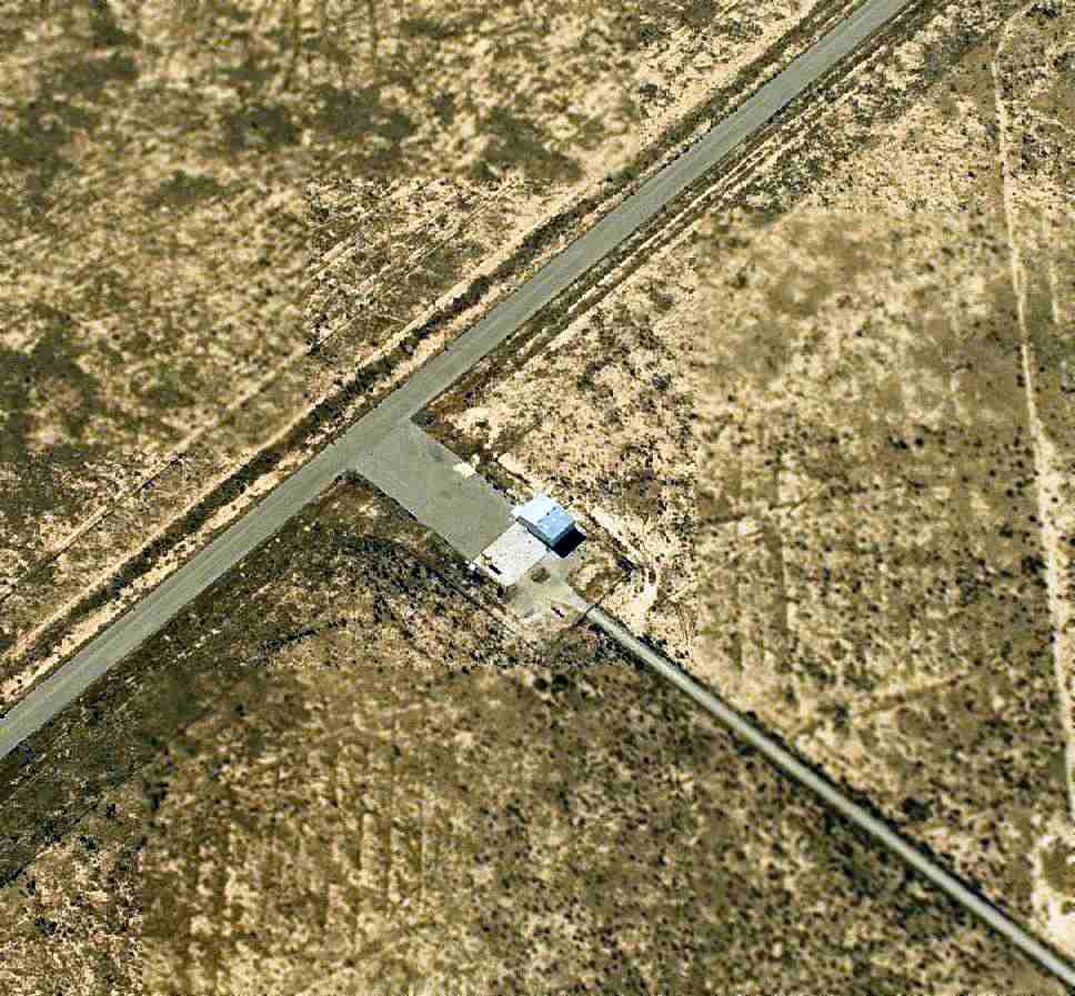
A circa 2006-2010 aerial view looking south at the hangar & runway of Milehigh Community Airfield, which appear perfectly preserved.
Shan Matin observed, “By 2012, the runway appears to be well maintained, and possibly in use.”
A 2015 aerial view looking north showed Milehigh Community Airport to remain intact.
____________________________________________________
Or if you prefer to contact me directly concerning a contribution (for a mailing address to send a check),
please contact me at: paulandterryfreeman@gmail.com
If you enjoy this web site, please support it with a financial contribution.
Or if you prefer to contact me directly concerning a contribution (for a mailing address to send a check),
please contact me at: paulandterryfreeman@gmail.com
If you enjoy this web site, please support it with a financial contribution.
____________________________________________________
This site covers airfields in all 50 states.