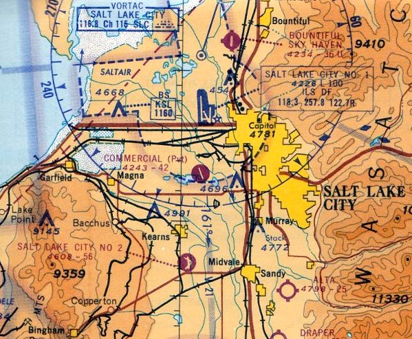
Abandoned & Little-Known Airfields:
Northeastern Utah
© 2002, © 2026 by Paul Freeman. Revised 3/20/26.
This site covers airfields in all 50 states: Click here for the site's main menu.
____________________________________________________
Please consider a financial contribution to support the continued growth & operation of this site.
Alta Airpark (revised 8/22/25) - Carter Sky Ranch / Draper Airport (revised 8/22/25) - Promontory Point Intermediate Field (revised 5/12/20)
(Original) Roosevelt Municipal Airport (revised 3/20/26) - Thiokol Air Force Plant 78 (revised 1/4/25) - Tremonton Municipal Airport (revised 8/22/25)
Utah Central Airport / Commercial Airport (revised 6/28/25) - West National Guard Airfield / Camp Williams Airfield (revised 8/4/19)
____________________________________________________
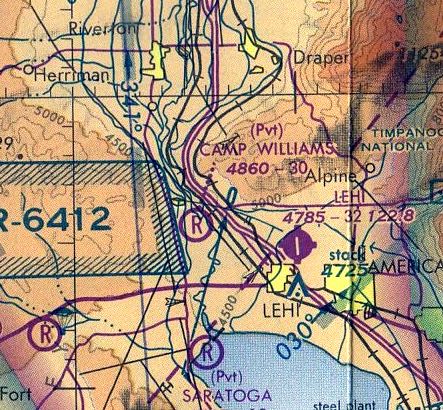
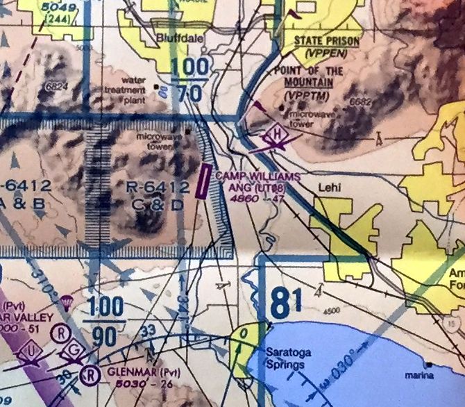
West National Guard Airfield / Camp Williams Airfield, Bluffdale, UT
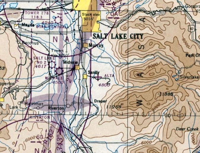
40.43, -111.93 (South of Salt Lake City, UT)
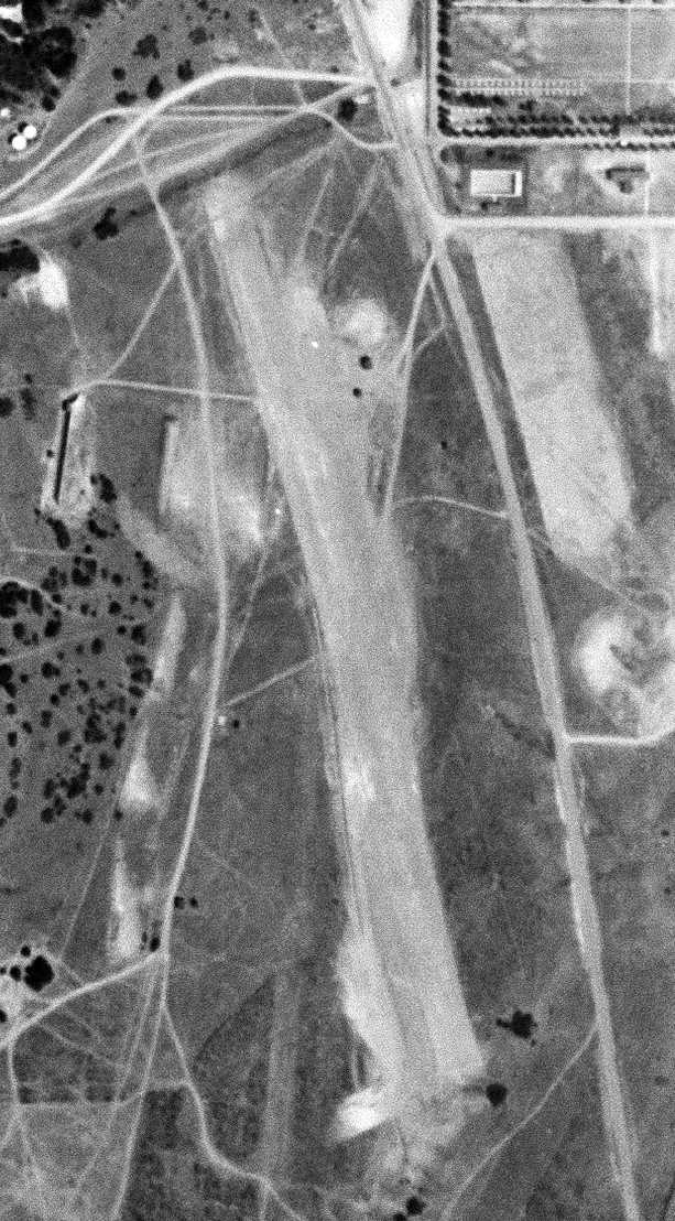
A 6/20/50 USGS aerial view of Camp Williams Airfield.
Camp Williams was created in 1926 as permanent training camp on 18,700 acres of land
south of Salt Lake City which had been withdrawn from the public domain in 1914.
The Camp Williams Airfield was not yet depicted on the September 1950 Salt Lake City Sectional Chart.
An airfield was evidently added at some point in 1950 southwest of the cantonment area.
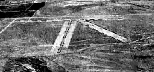
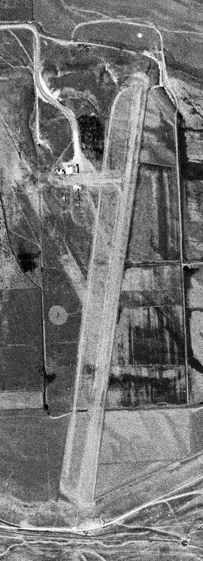
The earliest depiction which has been located of an airfield at Camp Williams was a 6/20/50 USGS aerial photo,
which depicted a single northwest/southeast runway, with a few small buildings on the northwest & northeast sides.
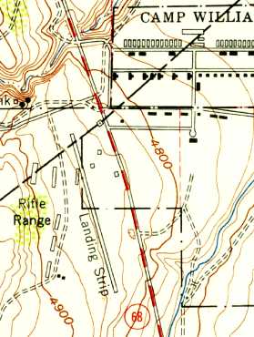
The 1951 USGS topo map depicted the Camp Williams Airfield
as having a single northwest/southeast runway, labeled simply as “Landing Strip”,
with a few small buildings on the northwest & northeast sides.
The earliest aeronautical chart depiction which has been located of the Camp Williams Airfield was on the March 1951 Salt Lake Sectional Chart.
It depicted “Camp Williams (NG)” Airfield as having a 2,500' unpaved runway.
The 1958 US Airport Directory (courtesy of David Brooks) depicted the “Camp Williams (Lehi)” airfield as having a 2,400' north-northwest/south-southeast runway.
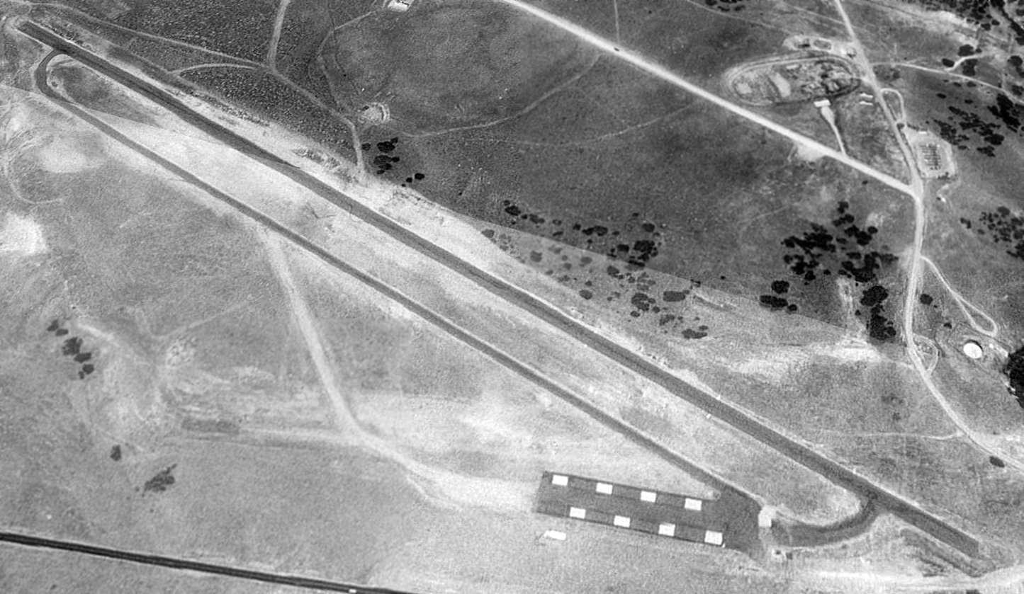
The earliest photo which has been located of the Camp Williams Airfield was a 1958 aerial view,
which depicted the field as having a 2,400' north-northwest/south-southeast unpaved runway, with a parallel paved ramp & a few small sheds.
Aerial photos from 1965, 1971, and 1977 showed the Camp Williams airfield having the same configuration,
but the runway appeared deteriorated & less distinct as time went on.
The May 1980 Salt Lake Sectional Chart (courtesy of Mitchell Hymowitz) depicted Camp Williams as a private airfield with a 3,000' unpaved runway.
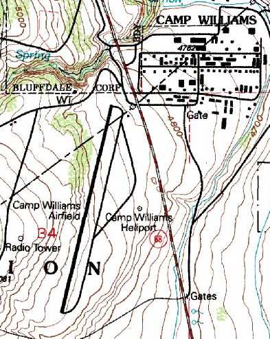
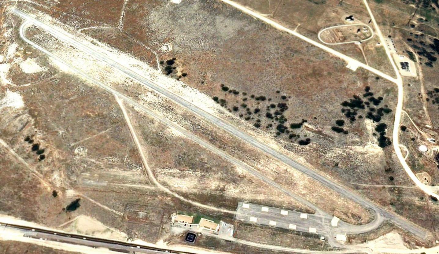
The 1993 USGS topo map shows that at some point between 1977-93 the previous NNW/SSE runway was replaced by a 4,700' north-northeast/south-southwest runway with a parallel taxiway.
An 8/14/93 USGS aerial photo looking southwest shows the Camp Williams Airfield to have a 4,700' north-northeast/south-southwest asphalt runway
with a parallel taxiway & a paved ramp on the northeast with 8 concrete parking pads.
A 1997 aerial view looking south showed that 2 small buildings had been built adjacent to the northeast side of the airfield at some point between 1993-97.
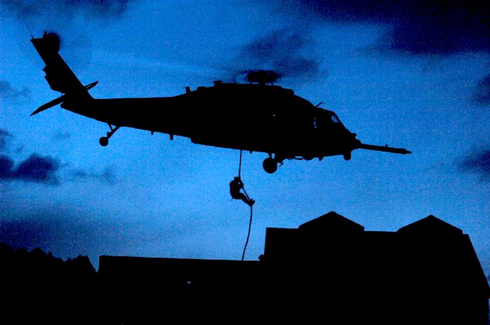
A 5/10/08 Air Force photo by Kevin Gruenwald of a member of the UT Army National Guard 19th Special Forces Group
fast roping from an Air Force HH-60 Pave Hawk helicopter into an urban village at night during the UT Combat Search & Rescue Joint Integration Exercise 2008 at Camp Williams.
The last aeronautical chart depiction which has been located of the Camp Williams Airfield was on the April 2009 Salt Lake Terminal Aeronautical Chart.
It depicted “Camp Williams ANG” as having a single 4,700' paved northeast/southwest runway.
The last photo which has been located showing the Camp Williams Airfield intact was a 6/23/09 aerial view looking southwest.
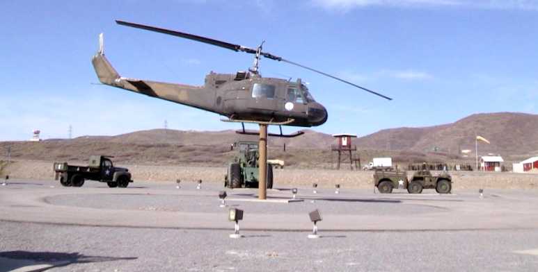
A pre-2012 photo of a UH-1 Huey mounted on a display pylon at Camp Williams Airfield.
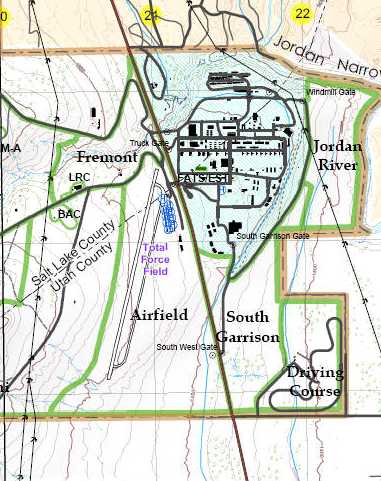
A pre-2012 map depicted the “Total Force Field” as having a single northeast/southwest runway with a parallel taxiway,
and a ramp with several parking spots on the northeast.
The Camp Williams Airfield was evidently closed at some point prior to 2010,
as a 6/18/10 aerial view showed that construction had begun for a large complex of buildings covering the former Camp Williams Airfield.
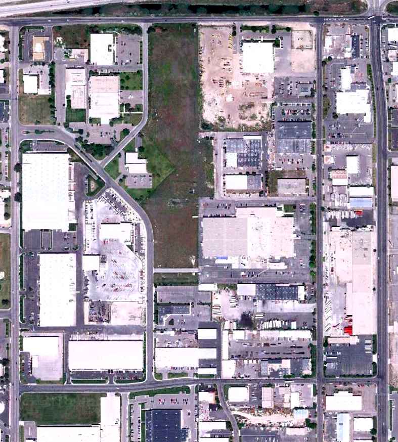
This facility is the National Security Agency's $1.5 billion Community Comprehensive National Cybersecurity Initiative Data Center.
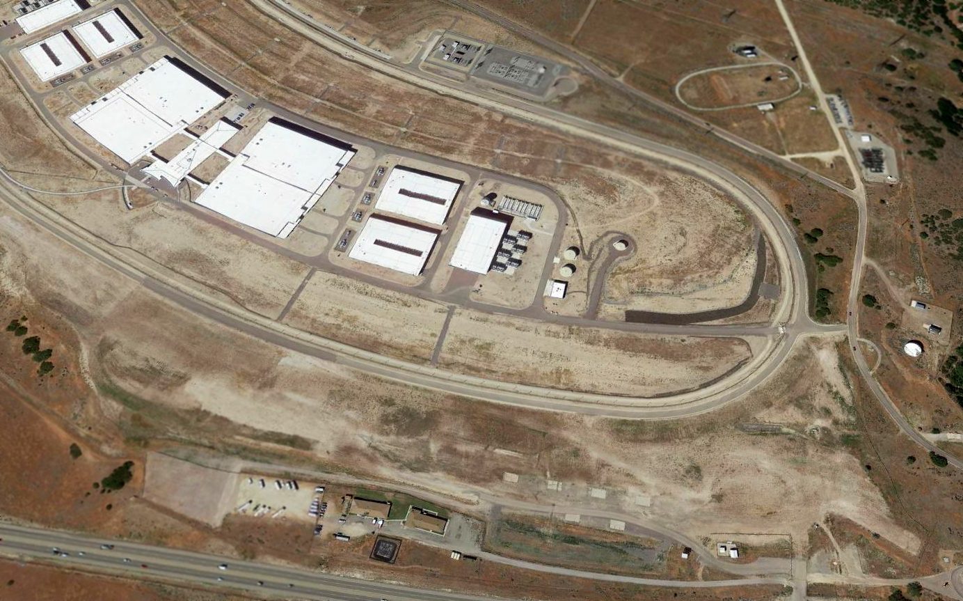
A 2016 aerial view looking southwest shows the NSA buildings covering the site of the Camp Williams Airfield,
but ironically a small segment of the northern-most tip of the runway remains recognizable, at bottom-right, along with several aircraft parking spots.
The site of Camp Williams Airfield is located south of the intersection of South Redwood Road & Jordan Narrows Road.
____________________________________________________
Utah Central Airport / Commercial Airport, Granger, UT
40.72, -111.97 (Southwest of Salt Lake City, UT)
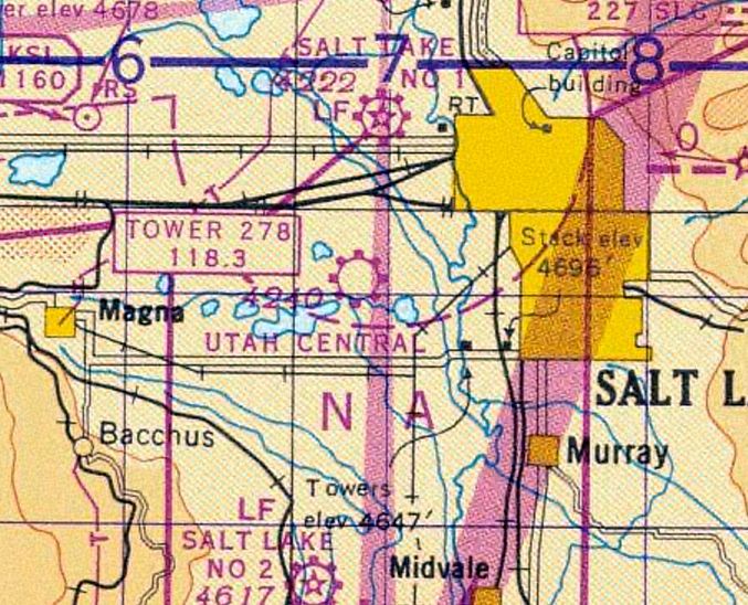
Utah Central Airport, as depicted on the August 1942 Salt Lake Sectional Chart.
According to Richard Van Wagoner, “In the spring of 1936 Vern Carter bought a large tract of land
in Salt Lake County at 21st South & 34th West & established the Utah Central Airport.”
Utah Central Airport was not yet depicted on the September 1941 Salt Lake Sectional Chart.
According to Charles Furden's monograph “Runway Dust”, “Utah Central had its beginnings shortly before the Second World War.
Its creation was the brainchild & sweat of one individual, Vern Carter.
He obtained legal access to the land, walked out into the brush, staked out the runways, and graded off the weeds, brush, and anthills.
By any definition it was a small country airport. Nothing paved & nothing fancy in the way of buildings.”
The earliest depiction which has been located of Utah Central Airport was on the August 1942 Salt Lake Sectional Chart.
It depicted Utah Central Airport as a commercial/municipal airport.
The earliest photo which has been located of Utah Central Airport was a circa 1942-45 aerial view in the 1945 AAF Airfield Directory (courtesy of Scott Murdock).
The directory described Utah Central Airport as a 200 acre rectangular property having 3 gravel, clay, and loam runways,
the longest being the 2,750' northwest/southeast strip.
The field was said to have 2 wood & metal hangars, the largest measuring 56' x 52'.
Utah Central Airport was described as being owned & operated by private interests.
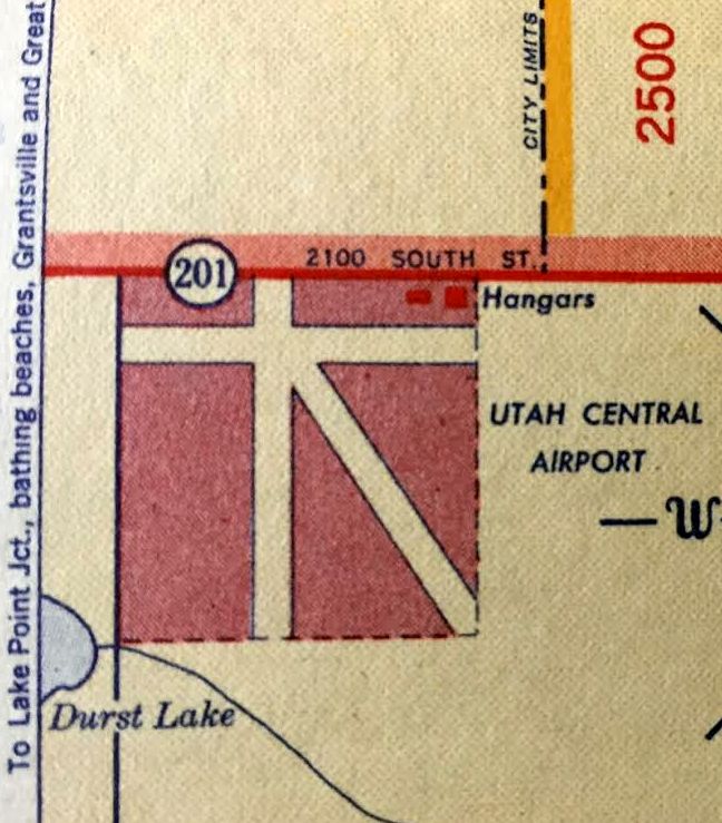
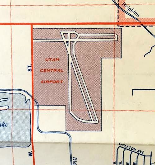
A 1947 street map (courtesy of Kevin Walsh) depicted UT Central Airport as having 3 runways & 2 hangars on the northeast corner.
The 1948 Salt Lake City Sectional Chart (courtesy of Roger Connor) depicted Utah Central Airport as a commercial/municipal airport.
A 1950 street map (courtesy of Kevin Walsh) showed the number of buildings depicted along the north side of UT Central Airport had increased to 6.
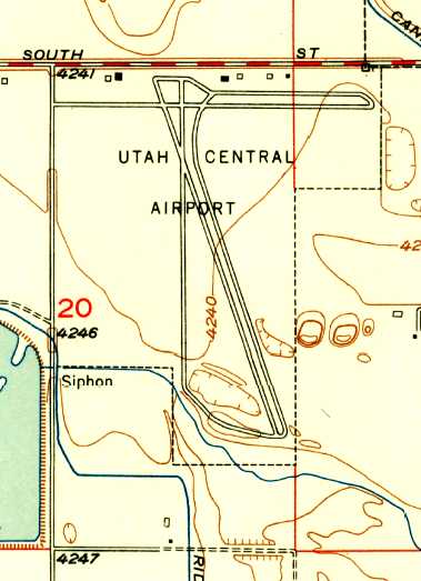
The 1951 USGS topo map depicted Utah Central Airport as having 3 runways, 2 parallel taxiways, and several small buildings along the north side.
According to Richard Van Wagoner, “Vern Carter operated Utah Central Airport until 1952.”
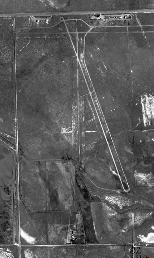
A 1958 aerial photo (courtesy of Bill Brown) depicted Utah Central Airport as a healthy little general aviation field,
with over a dozen light aircraft visible on the north side of the field, along with several rows of hangars.
There were a total of 3 runways, with the northwest/southeast runway being paved.
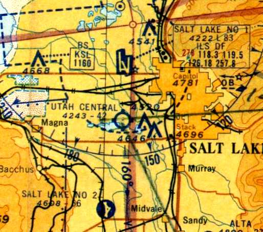
Utah Central Airport, as depicted on a circa 1950s-60s UT Aeronautical Chart (courtesy of Charles Furden).
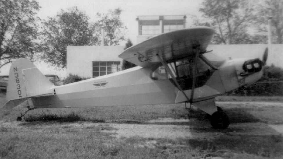
A circa 1950s-60s photo by Charles Furden of a J-3 Cub in front of Utah Central Airport's main office.
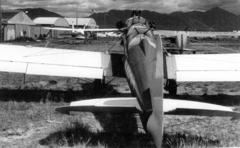
A circa 1950s-60s photo by Charles Furden of a Ryan P-22 parked in front of the Utah Central Airport hangars.
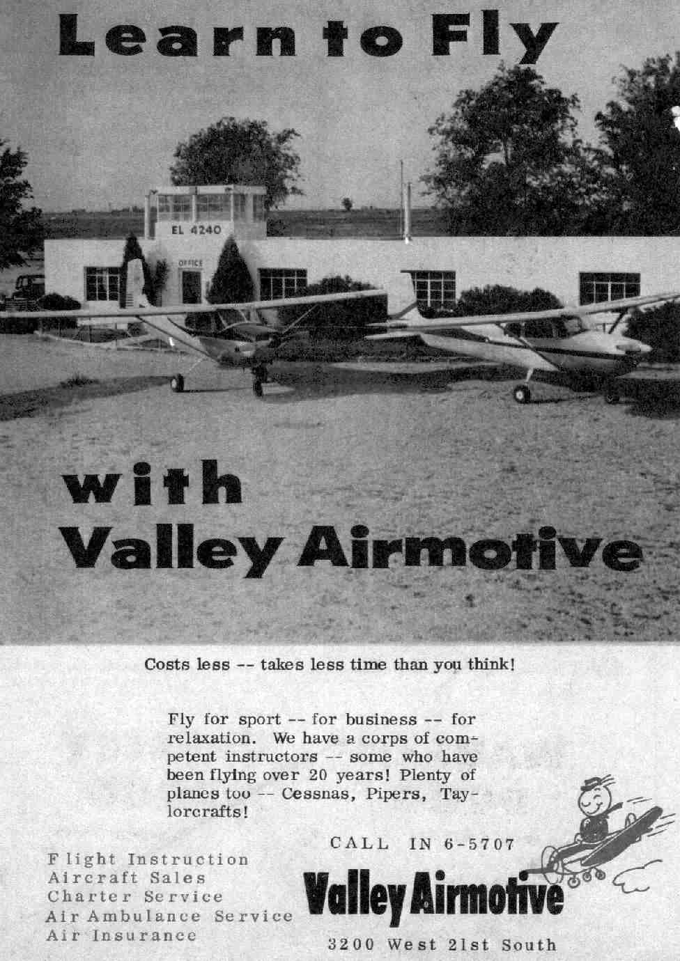
A circa 1950s-60s advertisement for Valley Airmotive (courtesy of Charles Furden) pictured 2 Cessnas in front of Utah Central Airport's office.
Utah Central Airport was still depicted as an active airfield on the 1963 USGS topo map.
Chris Dennis recalled, “Utah Central... a gravel strip, Runway 34/16, maybe about 2,100'.”
The proximity of Utah Central Airport to Salt Lake City's main airport was ultimately the reason for the little airport's demise.
When Utah Central was built, airline traffic at the main airport consisted predominantly of DC-3s, which flew relatively tight patterns.
But as larger & faster airliners became the norm, traffic patterns extended out much farther,
conflicting with the little general aviation airport only a few miles to the south.
The last aeronautical chart depiction which has been located of this airport was on the May 1965 Salt Lake Sectional Chart.
It had been renamed “Commercial” Airport, depicted as a private field with a single paved northwest/southeast 4,200' runway.
The last photo which has been located showing Utah Central Airport still in operation was an 11/9/65 USGS aerial photo.
It showed an odd juxtaposition in terms of the airport's development & health -
the eastern portion of the airport property (including the former primary runway, the northwest/southeast runway)
had evidently been redeveloped with non-airport construction.
Yet the north/south runway appeared to have been replaced with a paved runway & paved parallel taxiway.
The hangars on the northeast side were gone,
but a few hangars remained on the northwest side, around which were parked 5 single-engine planes.
The last dated reference to Utah Central Airport remaining in operation came from James Price,
who recalled, “I flew my first flight at Utah Central ($5) in the summer of 1966.”
A 1966 street map (courtesy of Kevin Walsh) depicted Utah Central Airport as having 3 runways & parallel taxiways.
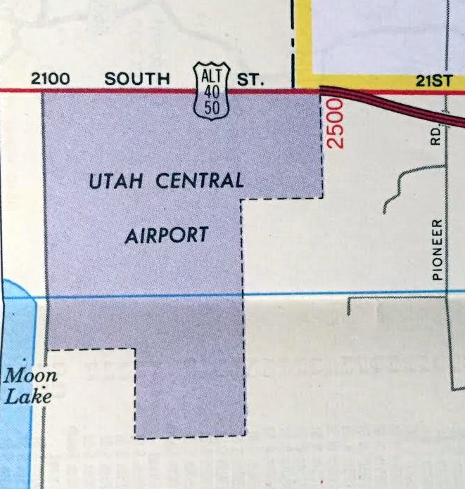
The last depiction which has been located of UT Central Airport was on a 1967 street map (courtesy of Kevin Walsh).
Utah Central Airport was presumably closed (for reasons unknown) at some point between 1966-69,
as it was no longer depicted on the December 1969 Salt Lake Sectional Chart or the 1970 USGS topo map.
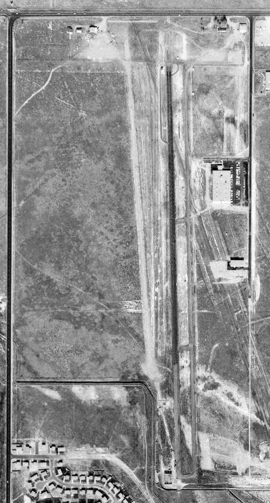
In a 1971 aerial photo, all of UT Central Airport's hangars were gone, but the paved north/south runway remained intact.
A 1977 aerial photo showed the remains of UT Central Airport's north/south runway still existed.
According to Chris L Dennis, “To my best recollection it disappeared in the late 1970s.”
The 1997 USGS aerial photo showed that the remains of UT Central Airport's north/south runway had been removed at some point between 1977-93.
A 1/18/10 aerial photo showed no evident trace remaining of Utah Central Airport,
but ironically the area of the former north/south runway remained an undeveloped grass field.
The site of Utah Central Airport is located southeast of the intersection of Route 201 & South 3600 West.
____________________________________________________
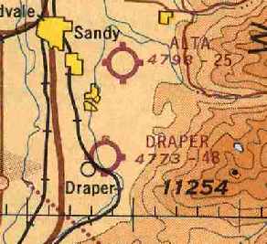
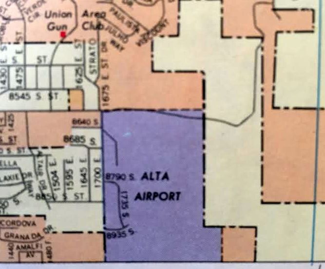
40.59, -111.84 (South of Salt Lake City, UT)
Alta Airpark, as depicted on the November 1946 Salt Lake Sectional Chart.
This small general aviation airport was evidently established at some point between 1945-46,
as it was not depicted on the August 1945 Salt Lake City Sectional Chart (according to Chris Kennedy)
nor listed among among active airfields in the 1945 AAF Airfield Directory (courtesy of Scott Murdock).
The earliest depiction which has been located of Alta Airport was on the November 1946 Salt Lake City Sectional Chart,
which depicted Alta as an auxiliary airfield.
Jim Madsen recalled, “My father, Robert Madsen, started Alta Air Park upon returning from flying in the Army Air Corps in World War 2.
I remember as a very young child going with him on many occasions to the airport. It was originally a teaching & charter service.
He owned & operated the airport for 5 or so years.”
The earliest photo which has been located of Alta Airpark was a 8/1/50 USGS aerial view.
It depicted Alta as having a single northeast/southwest runway with a parallel taxiway on the west side.
A ramp on the west side of the field had 2 buildings (hangars?), with a one single-engine aircraft visible outside.
Mike Howe recalled "joining a flying Club based at the old Alta Airpark while still in high school.
In 1958 there was nothing out here, except for the old airport on top of a hill with gullies at both ends.
It still conjures up fond memories of youth, the old hangar, leather couch, Coke machine
and of course the Sectional charts pasted to the wall with a string to plot trips to many exotic places.
I took lessons in an old Luscombe 8A & soloed just about my 15th birthday
and had my private while still in High school & spent all my time getting friends to buy gas for a ride."
The earliest photo which has been located of Alta Air Park was a 1958 aerial view.
It depicted the field as having a single unpaved runway with a parallel taxiway,
with a hangar & 8 single-engine aircraft on the west side.
Ken Despain recalled, “I spent many happy days at Alta Airpark during my high school years.
I met Curt Ellsworth in the fall of 1959. I drove up to the airport in the 1952 Chevy that I had just purchased to look at the airplanes.
My dad used to take us up there to look at the planes in the early 1950s,
so since I loved airplanes as soon as I had my own car I wanted to take in some airplane time on my own.
I parked my car & was looking at the Cessna 120, Luscombe 8A, and a few others, when Curt drove up.
He asked me what I was doing. I told him I loved airplanes & was taking in the view.
He asked if I'd like to learn to fly. Of course, I said I love to but there's no way I could afford it.
I just bought this car & don't have a job yet to pay for it. He said he'd give me a job & pay me in flying time! I jumped at the chance.
I spent the next 3 years working part time for him & learning to fly his brand-new Forney Aircoupe.
My instructor was Dudley Bray. He was a B-17 pilot during WWII. He soloed me after 13 hours of instruction.
One hour per month for 13 months. Curt charged $12.50 / hour for airplane, fuel & instructor.
He paid me $1.35 for each hour I worked, so it took me a while to earn enough for an hours instruction.”
Ken continued, “I spent most of my evenings after school doing odd jobs around the airport & just manning the place in case anyone came in & wanted fuel.
There wasn't a great deal of activity, but I did fuel a few planes & I tore down a bunch of engines & even helped rebuild a Mooney Mite.
Many of my days up there were spent alone.
I can still hear the sound of the wind whistling through the tubes the served as track for the hangar that had the Piper Tripacer in it.
Every time I hear a Meadow Lark sing it reminds me of Alta Airpark.
It was a great place to spend my youth & I don't remember thanking Curt for the wonderful opportunity he gave me. I really wish I had.”
The 1962 AOPA Airport Directory described "Alta Air Park" as having a single 2,700' gravel Runway 3/21.
The field was said to offer fuel, repairs, hangars, tie downs, and charter.
The operator was Curtis Ellsworth (an Aircoupe dealer).
Alta Airpark, as depicted on the May 1965 Salt Lake City Sectional Chart (courtesy of Chris Kennedy).
Alta Airpark was listed as the location of a 1965 accident
which resulted in substantial damage to a Stinson 108 due to a ground loop.
A 1965 aerial view depicted a total of 10 single-engine aircraft on the west ramp.
Houses had been constructed along the west side of the airfield at some point between 1958-65,
which would eventually prove the little airport's undoing.
Randy LeVitre reported, “The old Alta airport in Sandy City... The owner of Alta Aircraft Service at SLC Airport #2
was telling me about his days learning to fly there back in the 1960s & what a fun airport it had been.
He mainly remembered all the skydiving that went on there & how laid-back it was.”
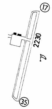
The 1967 Flight Guide (courtesy of Chris Kennedy) depicted Alta Airpark as having a single 2,230' Runway 17/35 with a parallel taxiway on the west side.
A ramp on the west side of the field had 2 buildings (hangars?) along the north side of the ramp.
The field was said to be attended during daytime, and to conduct skydiving operations.
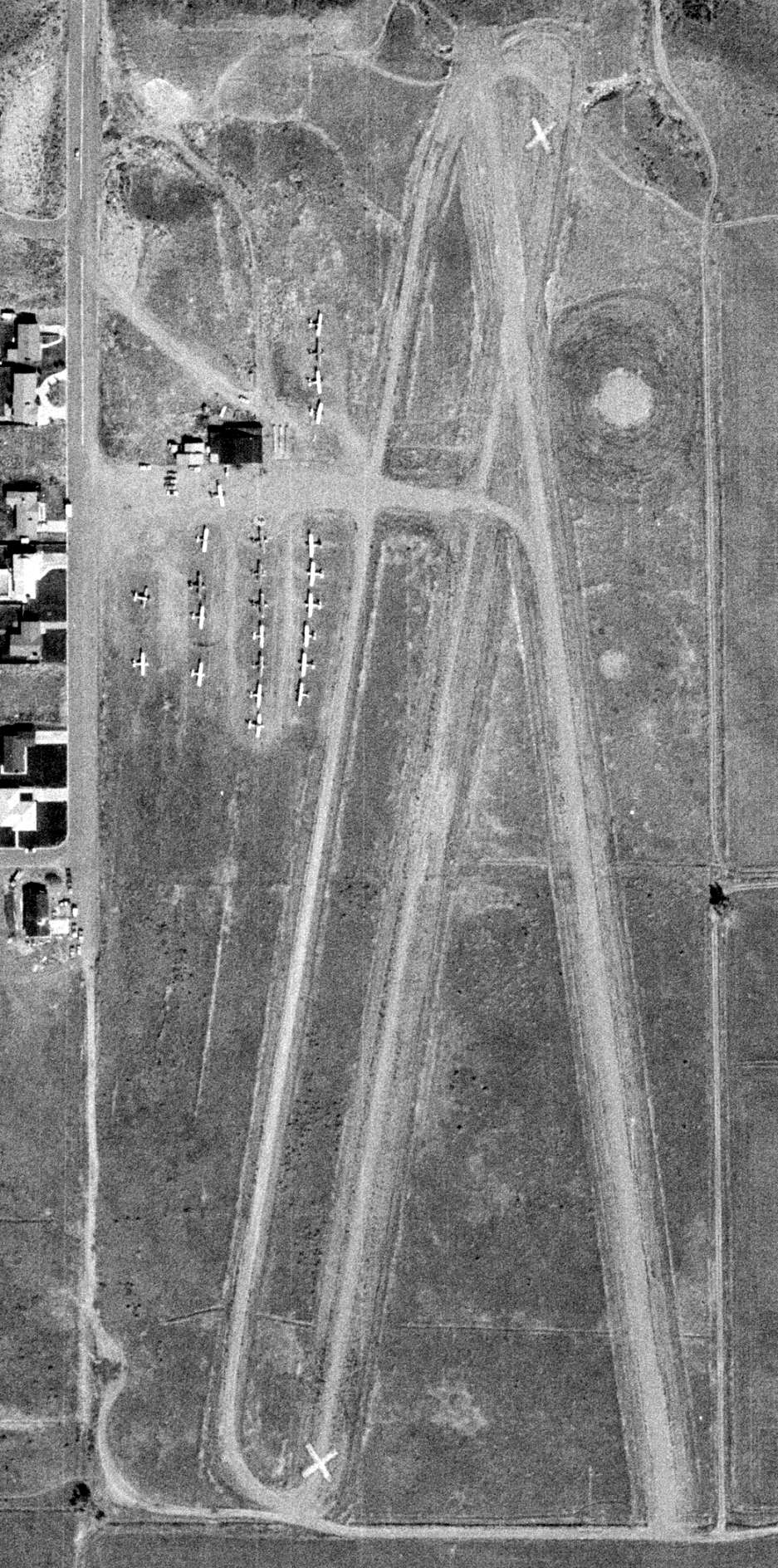
The last photo which has been located of Alta Airpark was a 10/7/70 USDA aerial view.
It showed that at some point between 1967-70 the former Runway 17/35 was painted with closed “X” markings, and replaced by a new Runway 16/34.
Alta Airpark appeared to be at its peak of popularity, with a total of 24 aircraft visible on the west side of the field.
Ray Vincent recalled, “I joined the BYU Sport Parachute Club in 1971 & we would jump at Alta Air Park.
Bill Dause was running the drop zone until he had to move to Tooele, when they started digging holes to build houses.
I remember the President of our club, Andy Baggs landing in a basement excavation, just before it closed.
Bill had a couple of Cessna airplanes from which we made our jumps. Occasionally we got to jump out of a Beechcraft in which we probably put 5-7 jumpers.
It was always interesting to watch the takeoff. There was gully & a water tank on the other side of it.
The runway was kind of short for that plane & sometimes dipped down a bit into the gully before clearing the water tank. Fun days.
My last jump there [was] around 1972.”
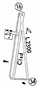
The 1972 Flight Guide (courtesy of Chris Kennedy) showed that Alta's former Runway 17/35 had been closed, and replaced by a new 2,300' Runway 16/34.
The field was still described as conducting skydiving operations.
The last aeronautical chart depiction which has been located of Alta Airpark was on the April 1974 Salt Lake City Sectional Chart,
which depicted Alta as having a 2,300' unpaved runway.
Alta Airpark apparently closed at some point between 1974-75, as it was no longer depicted on the 1975 USGS topo map.
The last depiction which has been located of Alta Airport was on a 1975 street map (courtesy of Kevin Walsh).
According to Brett Despain, Alta Airpark "closed in the late 1970s."
Cory Curtis recalled, “I moved to Sandy UT in 1976. Our 1st house was just 5 streets west of Piper Lane.
Piper Lane was the last street east before the old airstrip. Everything east of Piper Lane was just field & sagebrush.
It stayed that way until the late 1980s. Cameo Park subdivision (east of 1700 E) was just built when we moved in.
It was built after the airport had closed. I never saw the airport in use or any of the buildings. I think it closed between 1972-74.
As a kid in 4th grade we would ride our bikes to the landing strip. There wasn’t much left of it.
My friend would talk of how he would watch the skydivers & see the planes take off.”
A 1977 aerial view showed that housing completely covered the property, with not a trace remaining of Alta Airpark.
Alta Airport was no longer depicted at all on the May 1980 Salt Lake Sectional Chart (courtesy of Mitchell Hymowitz).
Ken Despain recalled, “When I returned to Utah in 1980 I drove up to have a look to see if Curt was still there,
when I discovered the airport was completely gone & houses where the the runway once was.”
Cory Curtis recalled, “They didn’t build over top the airfield until the late 1980s.
Cessna Circle is at the north of Glider Lane,
though this circle was built in the 1980s many years after the airport was closed.”
A 1993 USGS aerial photo showed that the site of the former Alta Airpark had been densely developed with housing,
and not a trace of the former airport appeared to remain.
Mike Howe recalled in 2004, "It was located just a few blocks from my present business in Sandy.
I can look from the roof & see about where it used to be.
It is now all subdivision & homes & no one would have known it was there
save for a few street signs with names like Cessna Circle & Piper Way."
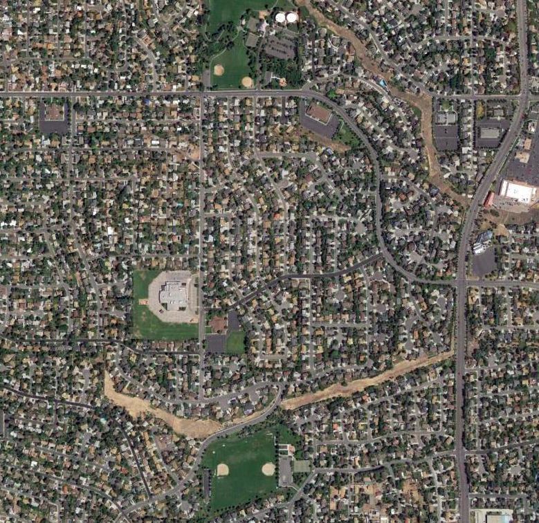
A 2016 aerial photo showed the site of Alta Airpark had been densely developed with housing, with not a trace of the former airport remaining.
The site of the former Alta Airpark is located at the intersection of Richard Lane & Newcastle Drive.
Thanks to Brett Despain for pointing out this airfield.
____________________________________________________
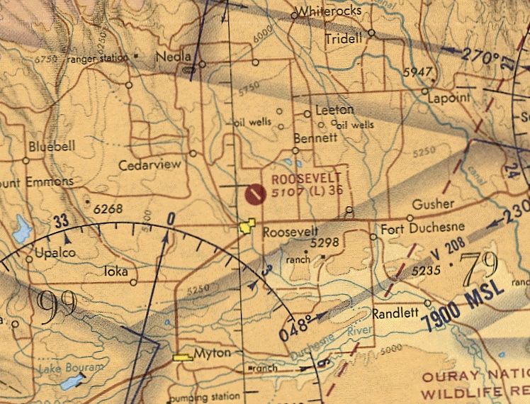
Roosevelt Municipal Airport (original location), Roosevelt, UT
40.325, -109.98 (Northeast of Las Vegas, NV)
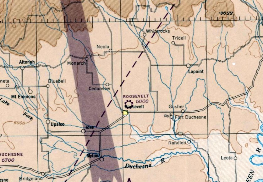
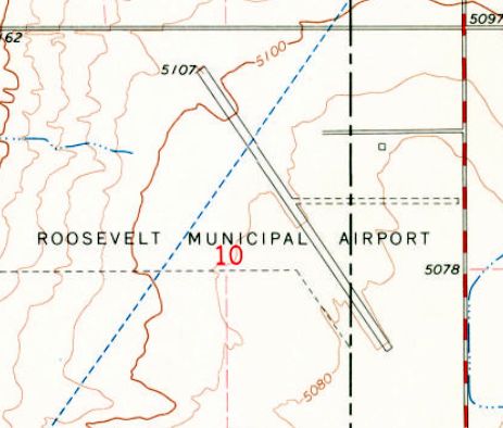
The original Roosevelt Municipal Airport, as depicted on the August 1945 Salt Lake Sectional Chart.
The original Roosevelt Municipal Airport was evidently built at some point between 1944-45,
as it was not yet depicted on a 1938 aerial photo or the September 1944 Salt Lake Sectional Chart,
or listed among active airfields in the 1945 AAF Airfield Directory (courtesy of Scott Murdock).
The earliest depiction which has been located of Roosevelt Municipal Airport was on the August 1945 Salt Lake Sectional Chart.
It depicted a single asphalt northwest/southeast runway, with an asphalt ramp on the east side, and a single hangar a good distance east of the ramp.
The 1962 AOPA Airport Directory described Roosevelt as having a single 3,600' bituminous Runway 13/31.
The 1964 USGS topo map depicted the original Roosevelt Municipal Airport as having a northwest/southeast runway,
with a single small building on the east side.
The last aeronautical chart depiction which has been located of the original Roosevelt Municipal Airport was the May 1971 Salt Lake Sectional Chart (courtesy of Ron Plante).
It depicted Roosevelt as having a single 3,600' paved northwest/southeast runway.
The original Roosevelt Municipal Airport was depicted on the 1977 USGS topo map as an active airfield.
At some point between 1971-78, the original Roosevelt Municipal Airport was evidently replaced by a newer & larger Municipal Airport to the southwest of the town.
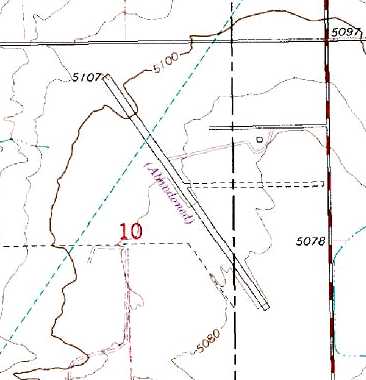
The original Roosevelt Municipal Airport was still depicted on the 1980 USGS topo map, but was labeled "Abandoned".
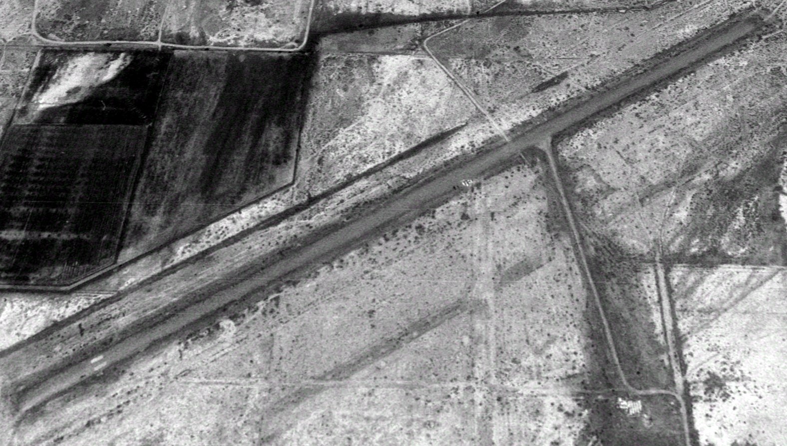
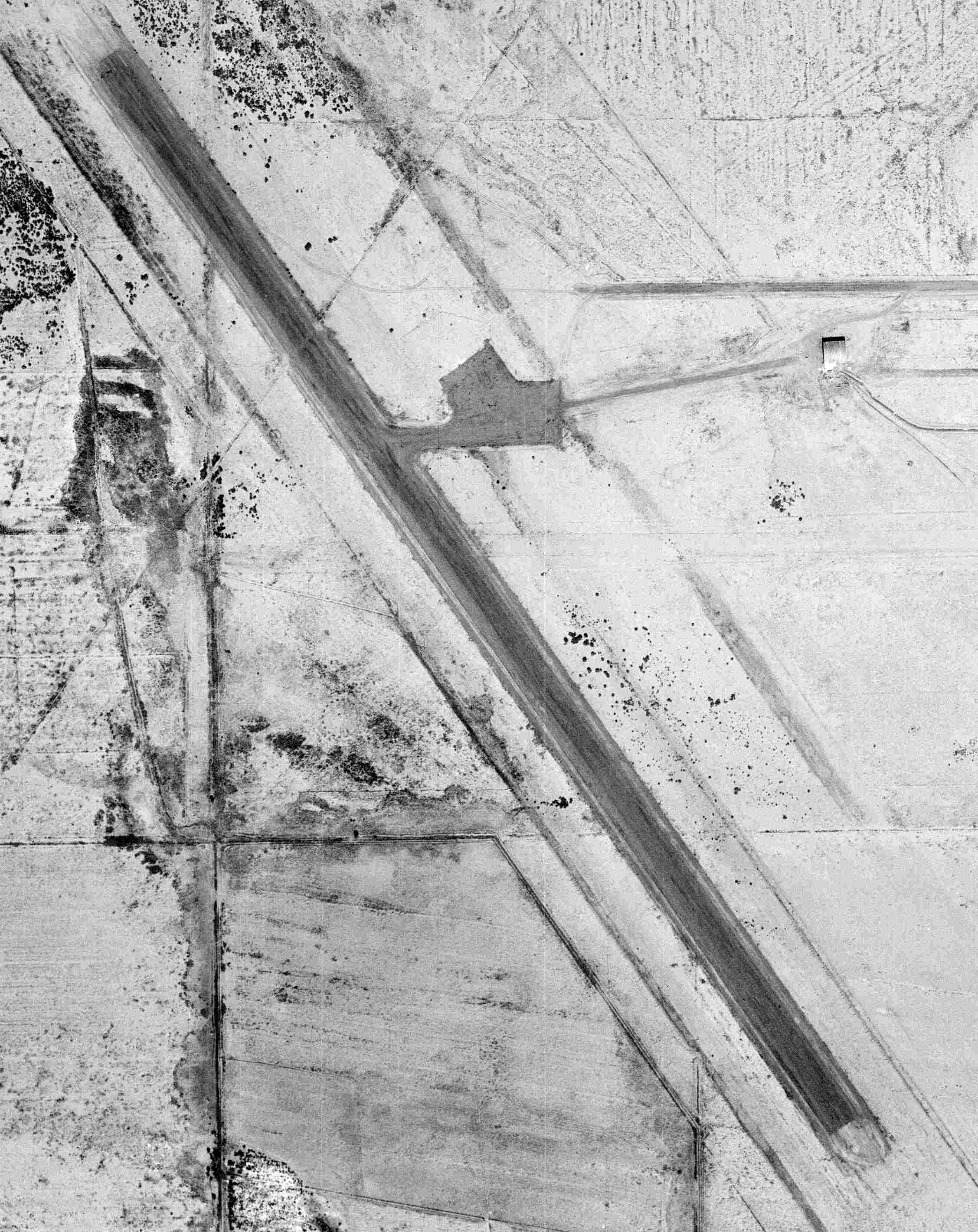
A 1997 USGS aerial view looking west showed the runway of the former Roosevelt Airport still appeared to be in fairly decent condition.
It was not marked with any closed runway symbols at all. A road led away to the east from the midpoint of the runway. There did not appear to be any trace of any buildings at the site.
The original Roosevelt Municipal Airport was depicted as an abandoned airfield on 2003 aeronautical charts.
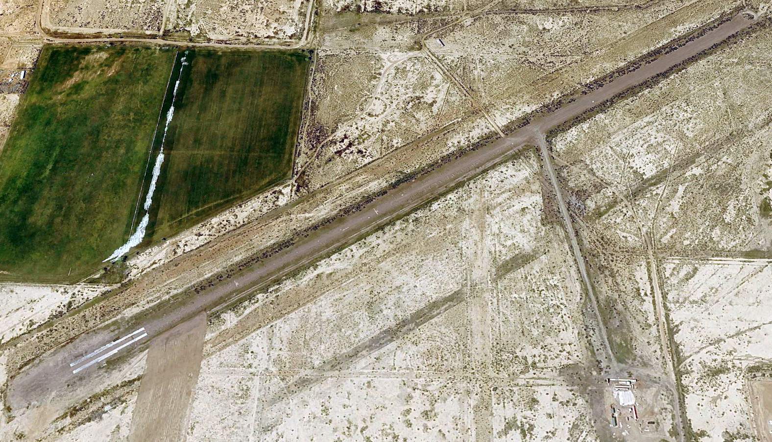
A 2023 aerial view looking west showed the runway at the original Roosevelt Municipal Airport remained in decent shape.
The site of the original Roosevelt Municipal Airport is located northeast of the intersection of North State Street & East 1200 North.
Thanks to Chris Kennedy for pointing out this airfield.
____________________________________________________
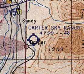
Carter Sky Ranch / Draper Airport, Draper, UT
40.535, -111.853 (South of Salt Lake City, UT)
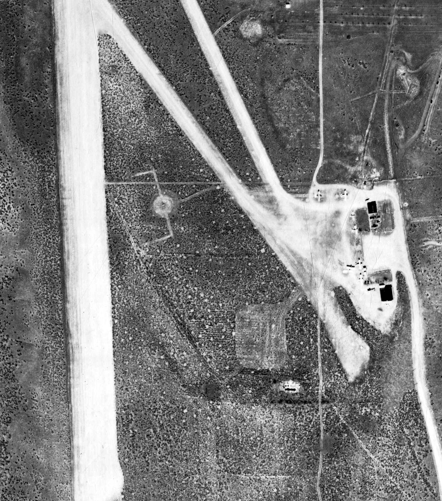
Carter Sky Ranch, as depicted on a 6/20/50 USGS aerial view.
This small general aviation airport was apparently established at some point between 1945-48,
as it was not yet listed among active airfields in the 1945 AAF Airfield Directory (courtesy of Scott Murdock).
The earliest reference to this airport which has been located came from Fred Orgill, who recalled,
“My father took flying lessons with Vern Carter operator of the site (Vern Carter & Jessie Carter, Sky Ranch Airport, 1948–64).”
Carter Sky Ranch was not yet depicted on the 1948 Salt Lake City Sectional Chart.
According to Richard Van Wagoner, “In 1948 Vern Carter purchased a tract of land on a Lake Bonneville bench at Draper
and opened the Carter Sky Ranch in 1950.”
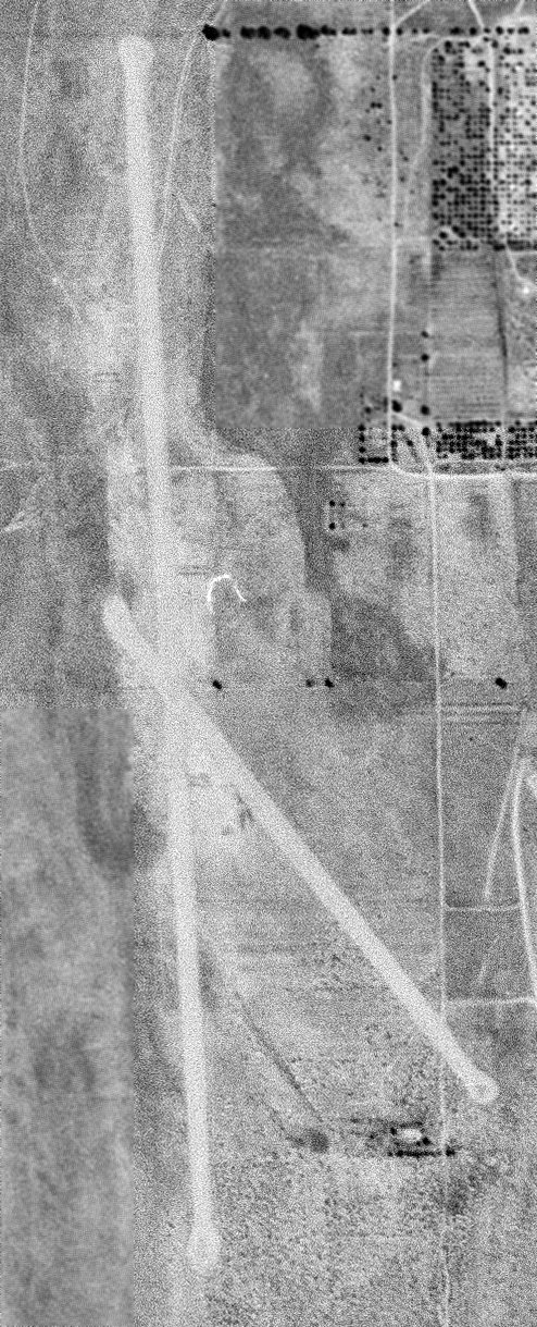
The earliest depiction which has been located of Carter Sky Ranch was a 6/20/50 USGS aerial view.
It depicted Carter Sky Ranch as having 2 unpaved runways, but there were no hangars or aircraft visible on the field.
The earliest aeronautical chart depiction which has been located of Carter Sky Ranch
was on the October 1955 Salt Lake City Sectional Chart (courtesy of Chris Kennedy).
It depicted Carter Sky Ranch as having a 4,800' unpaved runway.
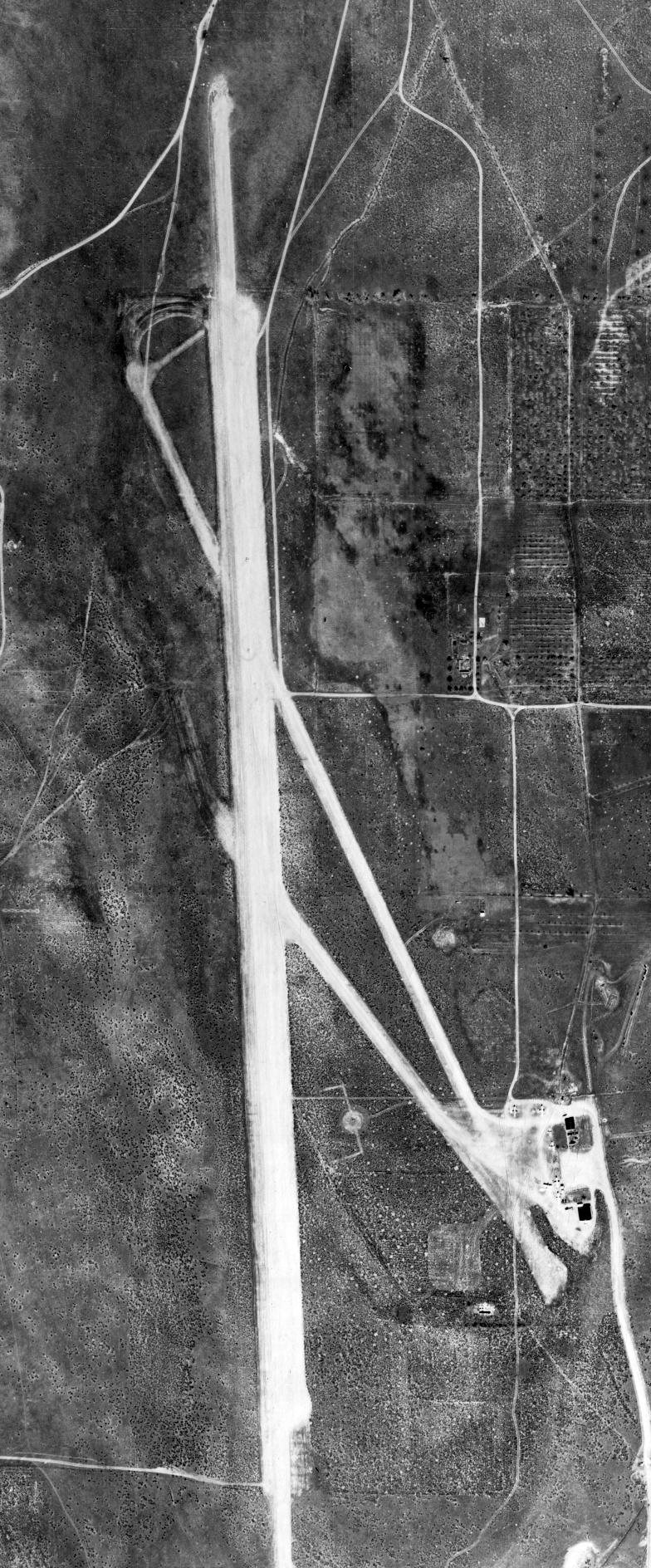
A 1958 aerial view depicted Carter Sky Ranch as having 3 unpaved runways, with a ramp & several small buildings on the southeast side.
According to Richard Van Wagoner, “Vern Carter sold the Draper property in 1960.”
The 1962 AOPA Airport Directory described "Carter Sky Ranch" as having 3 gravel runways, with the longest being the 4,800' Runway 16/34.
The field was said to offer fuel, repairs, tie downs, and charter. The operator was listed as Carter Air Service (a Piper dealer).
It was still depicted as "Carter Sky Ranch" on the October 1964 F-16 Operational Navigation Chart (according to Chris Kennedy).
It depicted Carter Sky Ranch as having 3 unpaved runways.
It had evidently been renamed "Draper Airport" at some point between 1964-65,
as that is how it was labeled on the May 1965 Salt Lake City Sectional Chart (courtesy of Chris Kennedy).
A 1965 aerial view depicted a total of 8 single-engine aircraft on the southeast ramp of Carter Sky Ranch.
It was still labeled as "Draper" Airport on the 1970 USGS topo map.
Draper Airport may have been closed by 1971, as a 1971 aerial view no longer depicted any aircraft on the field,
which otherwise appeared to remain intact.
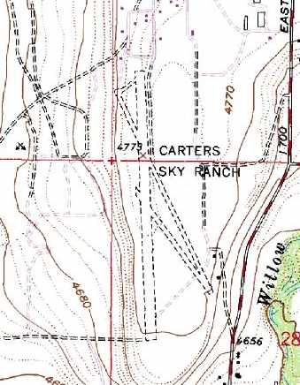
The 1975 USGS topo map labeled the field once again as "Carters Sky Ranch", and depicted 3 runways.
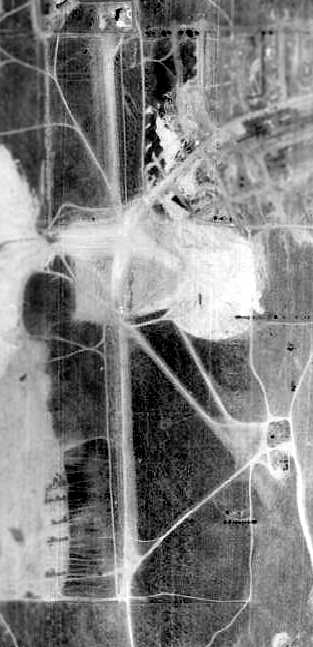
Carter Sky Ranch apparently closed at some point between 1965-77,
as it appeared to be abandoned in a 1977 aerial photo, and residential construction was approaching from the east.
The runways were largely intact, but land was being cleared on the center of the property,
the buildings at the southeast end had evidently been removed at some point between 1971-77.
Jim C. recalled, “Carter Skyranch in Draper... Vern Carter operated it, until the encroachment caused him to close it down.”
Carter Sky Ranch was no longer depicted at all on the November 1986 Salt Lake Sectional Chart (courtesy of Jim Hackman).
By the time of a 1993 USGS aerial photo, the site of Carter Sky Ranch has been densely developed with housing,
with no apparent remaining trace of the airport.
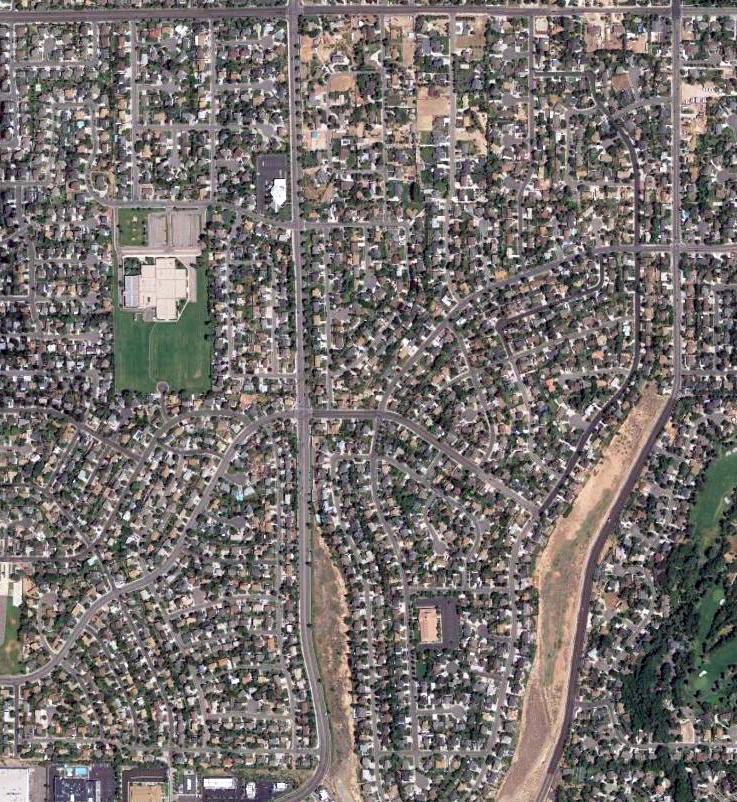
A 2016 aerial view showed the site of Carter Sky Ranch has been densely developed with housing,
and it does not appear as if any trace of the airport remains.
The site of Carter Sky Ranch is located east of the intersection of Hidden Valley Drive & South 1300 East.
Thanks to Brett Despain for pointing out this airfield.
____________________________________________________
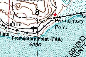
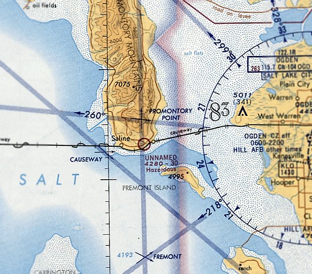
Promontory Point Intermediate Field, Promontory Point, UT
41.212, -112.435 (Northwest of Salt Lake City, UT)
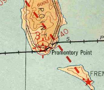
Promontory Point Intermediate Field, as depicted on a May 1930 Airway Map (courtesy of Chris Kennedy).
The location of "Promontory Point" was made famous in 1869,
when the "Golden Spike" was driven to join the Central Pacific & Union Pacific Railroads,
forming a transcontinental link spanning the United States.
The location of the railroad linkage was actually 30 miles north of Promontory Point.
At some point in the 1920s or 1930s, an airfield was constructed on the very tip of Promontory Point,
which juts out into the Great Salt Lake.
The Promontory Point airfield was one of the Department of Commerce's network of Intermediate Fields,
which were constructed in the 1920s & 1930s along airways between major cities.
They were intended for emergency use by commercial aircraft.
The earliest reference to the Promontory Point airfield which has been located
was on a May 1930 Airway Map (courtesy of Chris Kennedy).
A 1933 Department of Commerce Airport Directory (courtesy of Chris Kennedy)
described Promontory Point as Site 3 along the Salt Lake - El Paso Airway.
It was described as consisting of a 3,000' x 1,410' rectangular sod field,
with boundary & approach lights, and a rotating beacon.
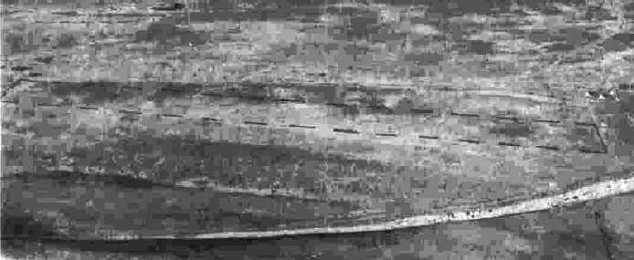
The earliest depiction which has been located of Promontory Point Intermediate Field
was a circa 1942-45 aerial view looking north in the 1945 AAF Airfield Directory (courtesy of Scott Murdock).
It described Promontory as a 51 acre irregularly-shaped property having a 3,000' “sod” east/west landing strip [probably not a lot of “sod” there].
The field was not reported to have any hangars, to be owned by private interests, and operated by the Civil Aeronautics Administration.
The Promontory Point airfield was still depicted as Site 3 on the 1948 Salt Lake City Sectional Chart.
It was labeled "Promontory Point (CAA)" on the October 1955 Salt Lake City Sectional Chart (courtesy of Chris Kennedy),
and described as having a single 3,000' sandy runway.
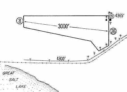
The 1960 Jeppesen Airway Manual (courtesy of Chris Kennedy)
depicted the "Promontory Point FAA" airfield as having a single 3,000' unpaved runway,
along with 2 small buildings on the northeast corner of the field.
The status of the Promontory Point airfield apparently changed to a private field at some point between 1955-65,
as that is how it was depicted on the May 1965 Salt Lake Sectional Chart (courtesy of Chris Kennedy).
It was described as having a single 3,000' dirt runway.
The 1970 USGS topo map still labeled the airfield as "Promontory Point (FAA)",
but the field had probably ceased to have any connection to the FAA years before then.
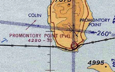
The last aeronautical chart depiction which has been located of the Promontory Point airfield was on the December 1971 Salt Lake Sectional Chart (courtesy of Ron Plante).
Strangely though, it was labeled generically as “Unnamed”, and described as having a “hazardous” 3,000' unpaved runway.
The Promontory Point airfield was no longer depicted on the May 1980 Salt Lake Sectional Chart.
A single east/west runway was depicted on the 1983 USGS topo map,
but it was labeled simply as "Landing Strip", which most likely indicates that the field was abandoned by that point.
By the time of the 1991 USGS topo map, the runway was no longer depicted at all.
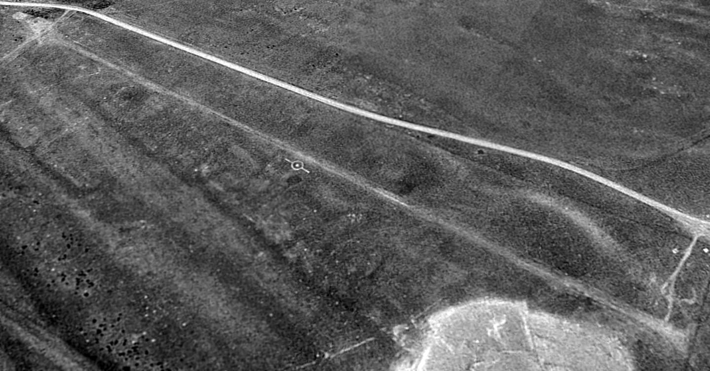
A 1993 USGS aerial view looking northwest showed the outline of the single runway was still quite apparent at Promontory Point, along with a segmented circle indicator, just south of the runway midpoint.
There was no sign of any buildings at the site.
However, Brent Watson reported in 2005, “The Promontory Point airstrip... is used on an annual basis during the brine shrimp harvesting season.
During the annual harvest there are 6-10 aircraft stationed there.
There is usually a temporary fuel tank, and there is also housing for the pilots & shrimping crews
(there is also a dock nearby where the shrimping boats are launched & tied off).
The harvest is in the fall, around the first of October, and can run through January.
The length of the season is determined by the count of available cists (eggs).”
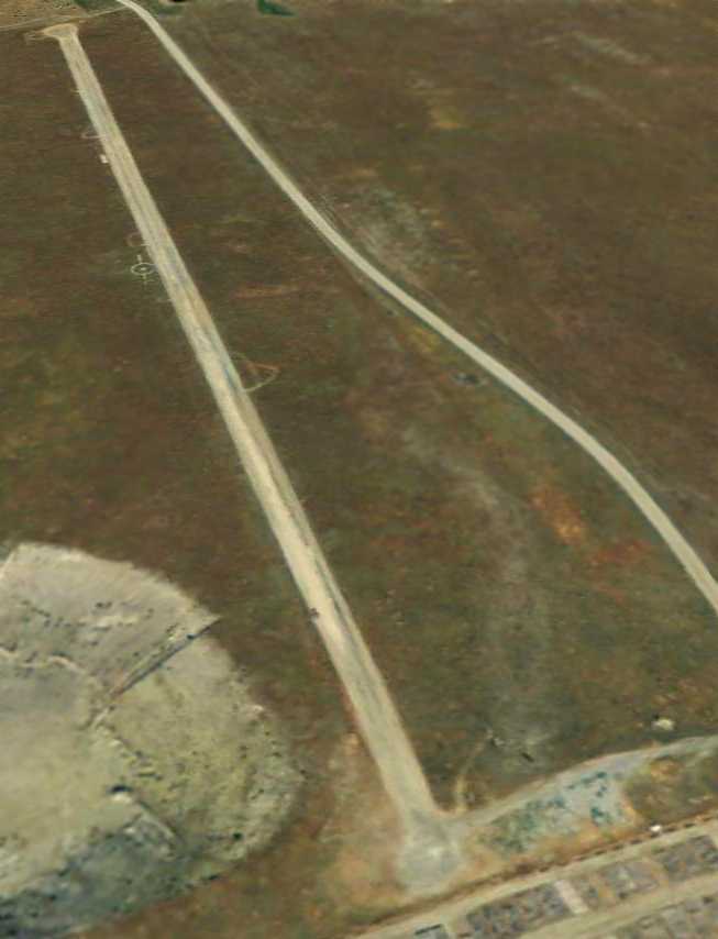
A 9/15/11 aerial view looking northwest along the Promontory Point runway,
also showing the segmented circle indicator just south of the runway midpoint.
The Promontory Point airfield is located south of East Promontory Road & north of Southern Pacific Railroad.
____________________________________________________
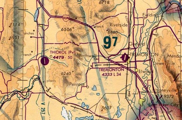
Thiokol Air Force Plant 78 Airfield (UT23), Howell, UT
41.715, -112.447 (Northwest of Salt Lake City, UT)
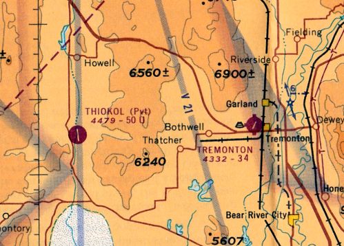
Thiokol Airfield, as depicted on the May 1965 Salt Lake Sectional Chart (courtesy of Ron Kunse).
This private airfield is located adjacent to a Thiokol rocket motor production facility, which is designated Air Force Plant 78.
No airfield at this location was listed in the 1945 AAF Airfield Directory (courtesy of Scott Murdock) or depicted on a 1959 aerial photo.
NASA employee Larry Nemecek recalled, "The Thiokol Airfield was originally built by the USAF
as part of the Air Force Plant 78 Complex in the late 1950s or early 1960s.
Aircraft that typically used the field were cabin class twins such as Cessna 421s & King Airs as well as a few corporate jets.
It is rumored that some heavy Air Force C-121 [Lockheed Constellations] also landed there."
The Thiokol airfield was not depicted on the October 1960 Salt Lake Sectional Chart nor listed among active airfields in the 1962 AOPA Airport Directory.
The industrial facility was completed in 1962, and was designed for the manufacture of Minuteman first stage rocket motors.
Air Force Plant 78 covers 20,000 acres, and has 2.5 million square feet of floor space.
The combined production of AFP 78 & the adjacent Thiokol plant reached a peak manufacturing rate in 1963.
The earliest reference which has been located of this airfield was on the May 1965 Salt Lake Sectional Chart (courtesy of Ron Kunse).
It depicted "Thiokol" as a private airfield having a single 5,000' paved runway.
The 1970 USGS topo map depicted the airfield, and labeled the area bordering the airfield to the east as "Air Force Plant 78".
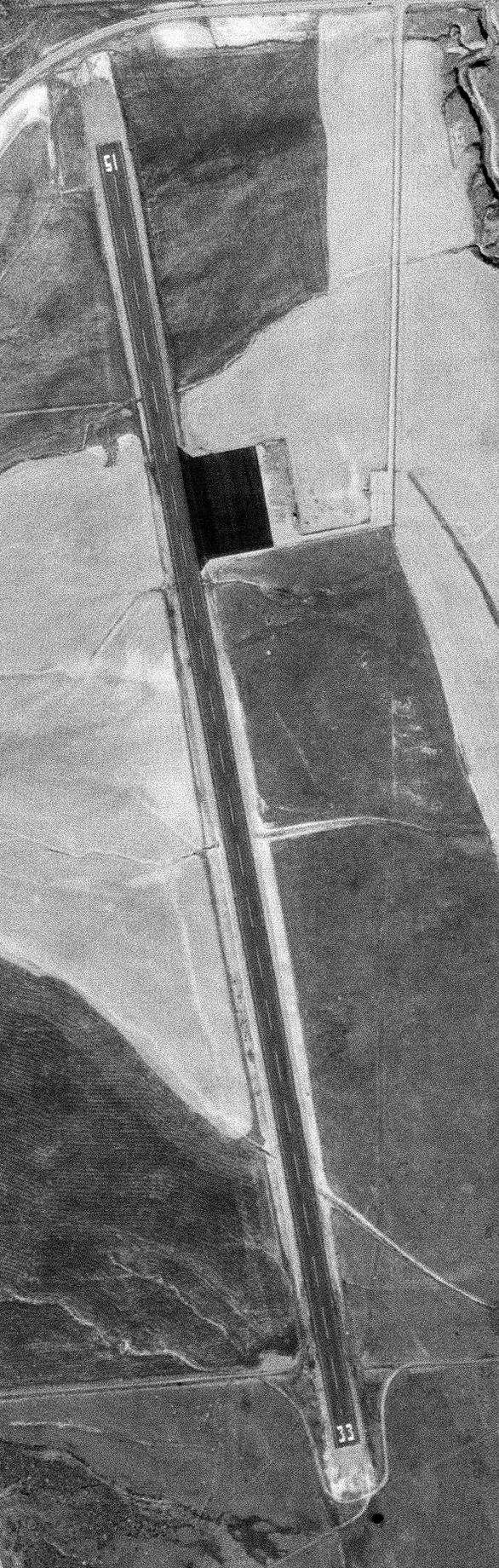
The earliest photo which has been located of the Thiokol Airfield was a 10/7/71 USGS aerial photo.
It depicted Thiokol as having an asphalt Runway 15/33, with an asphalt ramp on the northeast side.
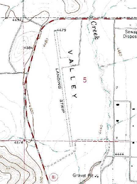
The 1972 USGS topo map depicted the Thiokol “Landing Strip” as a single north/south runway, with a ramp on the northeast side.
At the end of the Minuteman project, the USAF attempted to sell the plant to Morton Thiokol,
but the 2 sides could not agree on a price.
As of 1986, the facilities supported the MX Peacekeeper, the Trident II & Standard Missile programs.
The last aeronautical chart depiction which has been located of Thiokol Airfield was on the May 1980 Salt Lake Sectional Chart (courtesy of Paul Columbus).
It depicted Thiokol Airfield as having a 5,000' paved north/south runway.
The 1982 AOPA Airport Directory (courtesy of Ed Drury) described Thiokol airfield as having a single 5,000' asphalt Runway 15/33.
The remarks said, "Private. Closed to public."
The Thiokol Airfield was depicted as an abandoned airfield on the November 1986 Salt Lake Sectional Chart (courtesy of Jim Hackman).
Thiokol finally purchased the former Air Force Plant 78 complex in 1995.
Larry Nemecek said "Thiokol bought the entire Plant 78 complex from the Air Force in the mid-1990s.
Thiokol subsequently decided that it was not cost-effective to upgrade/repair/maintain the airfield for their corporate jet use so it was closed at that time.
Corporate Management decided that it was more cost effective to move their aviation assets to Ogden Airport
than to repair & upgrade the strip to handle corporate jets on high density altitude days.
Ogden is also more convenient to travelers than the 50 mile drive to the Thiokol main plant."
In the 1993 USGS aerial photo of the Thiokol Airfield, closed-runway "X" symbols were visible on both ends of the runway.
A small paved ramp was located along the east side of the runway, but there were no aircraft or hangars.
Larry Nemecek observed in 2003, "It is currently being used as a storage pad to store various large containers."

A 2023 aerial view looking southeast showed the Thiokol Airfield runway remain completely intact, and a building had been added next to the ramp at some point between 2017-2020.
The Thiokol Airfield is located south of the intersection of Route 83 & North 18000 West Street.
____________________________________________________
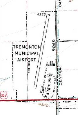
Tremonton Municipal Airport (U27), Tremonton, UT
41.717, -112.185 (North of Salt Lake City, UT)
Tremonton Municipal Airport, as depicted on an 8/8/46 USDA aerial photo.
Tremonton Municipal Airport was evidently built at some point between 1945-46,
as it was not yet listed among active airfields in the 1945 AAF Airfield Directory (courtesy of Scott Murdock).
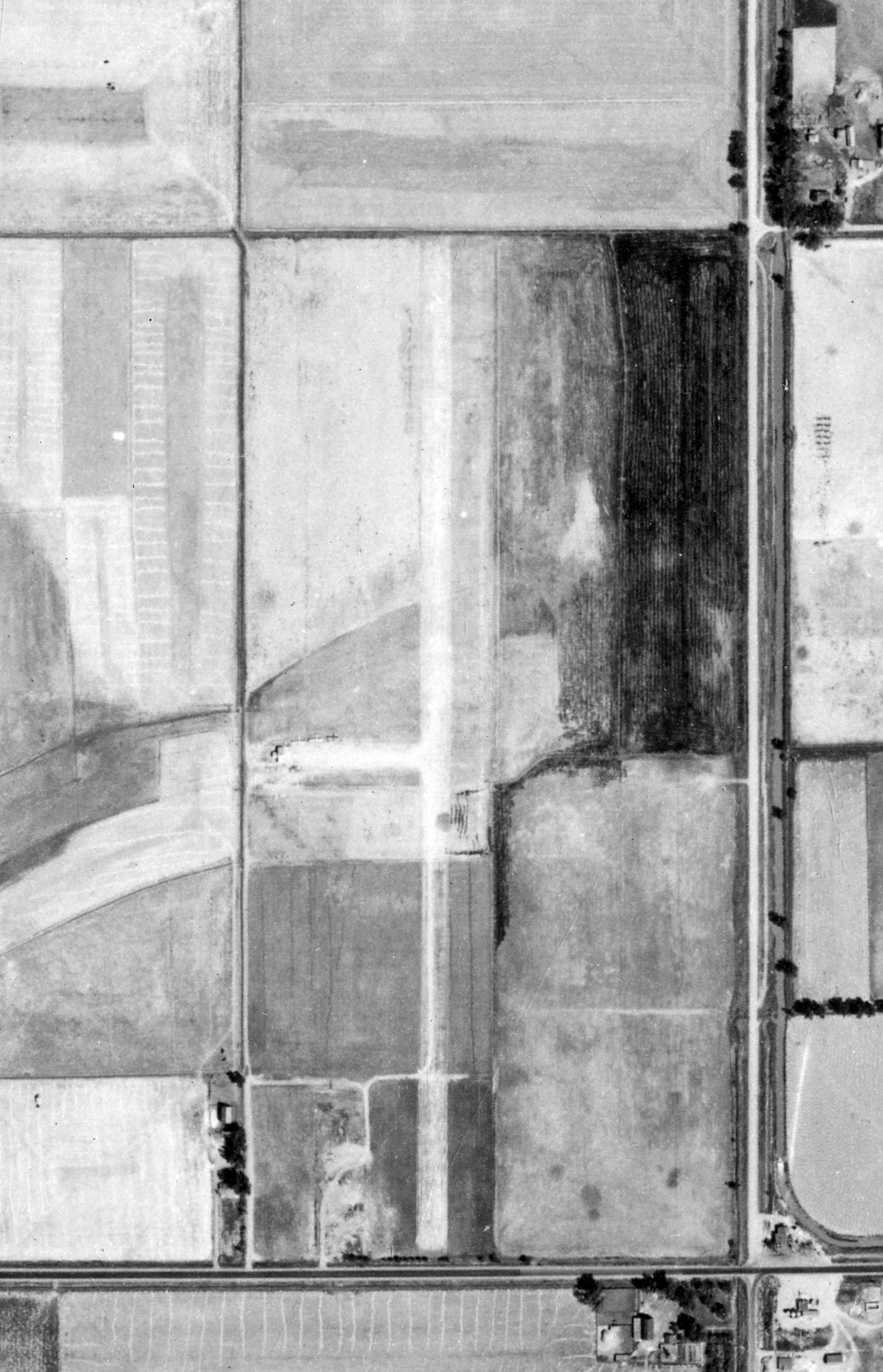
The earliest depiction which has been located of Tremonton Municipal Airport was on an 8/8/46 USDA aerial photo.
It depicted a single unpaved north/south runway, with 3 light single-engine planes parked near a small building on the west side.
Tremonton Municipal Airport was not yet depicted on the November 1946 Salt Lake Sectional Chart.
The earliest aeronautical chart depiction which has been located of Tremonton Municipal Airport was on the May 1947 Salt Lake Sectional Chart.
It depicted Tremonton as a commercial/municipal airport.
The 1948 Haire Airport Directory (according to David Brooks) described Tremonton Municipal Airport as having a “turf” runway [probably not a lot of “turf” there].
The September 1949 Great Salt Lake World Aeronautical Chart (courtesy of Donald Felton)
described Tremonton as having a 3,700' hard-surface runway (it had evidently been paved within the previous year).
The 1955 Salt Lake City Sectional Chart (according to Chris Kennedy)
described Tremonton as having a single 3,720' bituminous runway.
A 1959 aerial view depicted Tremonton Municipal Airport as having a single asphalt northeast/southwest runway, with an asphalt ramp on the west side, with a hangar & 4 T-hangars.
The 1962 AOPA Airport Directory described Tremonton Municipal as having a single 3,445' bituminous Runway 2/20.
The May 1965 Salt Lake Sectional Chart (courtesy of Ron Kunse)
depicted Tremonton Municipal Airport as having a 3,400' paved runway.
The 1982 AOPA Airport Directory (courtesy of Ed Drury)
described Tremonton Municipal as having a single 3,445' asphalt Runway 17/35.
The operators were listed as Airmotive Service & Basin Flying Service Inc.
The last aeronautical chart depiction which has been located of Tremonton Municipal Airport
was on the November 1986 Salt Lake Sectional Chart (courtesy of Jim Hackman).
It depicted Tremonton Municipal Airport as having a 3,400' paved runway.
Tremonton Municipal Airport was still depicted as an active airfield on the 1991 USGS topo map.
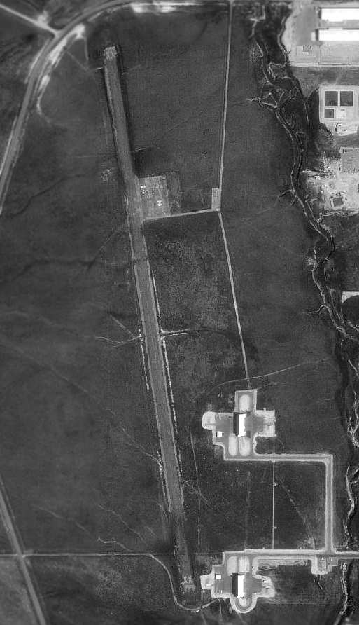
The last photo which has been located showing Tremonton Municipal Airport while open was a 1993 USGS aerial view looking northwest.
There were 3 light single-engine aircraft visible on the ramp at the southwest corner, near several small hangars.
According to the Experimental Aircraft Association's Salt Lake City Chapter newsletter (via Chris Kennedy),
Tremonton Municipal Airport closed on 12/31/99.
In the words of Andy Venable, "Wayne Larson, airport manager & owner of Airmotive Service
hosted a fly-in party for everyone to say their good-byes to the 50-year-old airport.
At one time, there were ten or more Super Cubs based on the field & just about every one of them was used for the sheep business.
Either going after the pesky coyotes killing their lambs or carrying groceries out to the herders in the hinterlands of Box Elder County,
or just locating stray cows & sheep.
Those days have pretty much passed on, but the airport survived & served the community well in many other areas,
such as aerial spraying, until now."
"A lifetime of memories for hundreds of people & a whole new generation are gone.
This is sad for all general aviation. Why did it close?
Elected city officials decided that a parking lot for the rodeo grounds
is more important to the well being of Tremonton City than the airport."
Wayne Larson relocated Airmotive Service to the Brigham City Airport.
Tremonton Municipal Airport was depicted as an abandoned airfield on 2003 aeronautical charts.
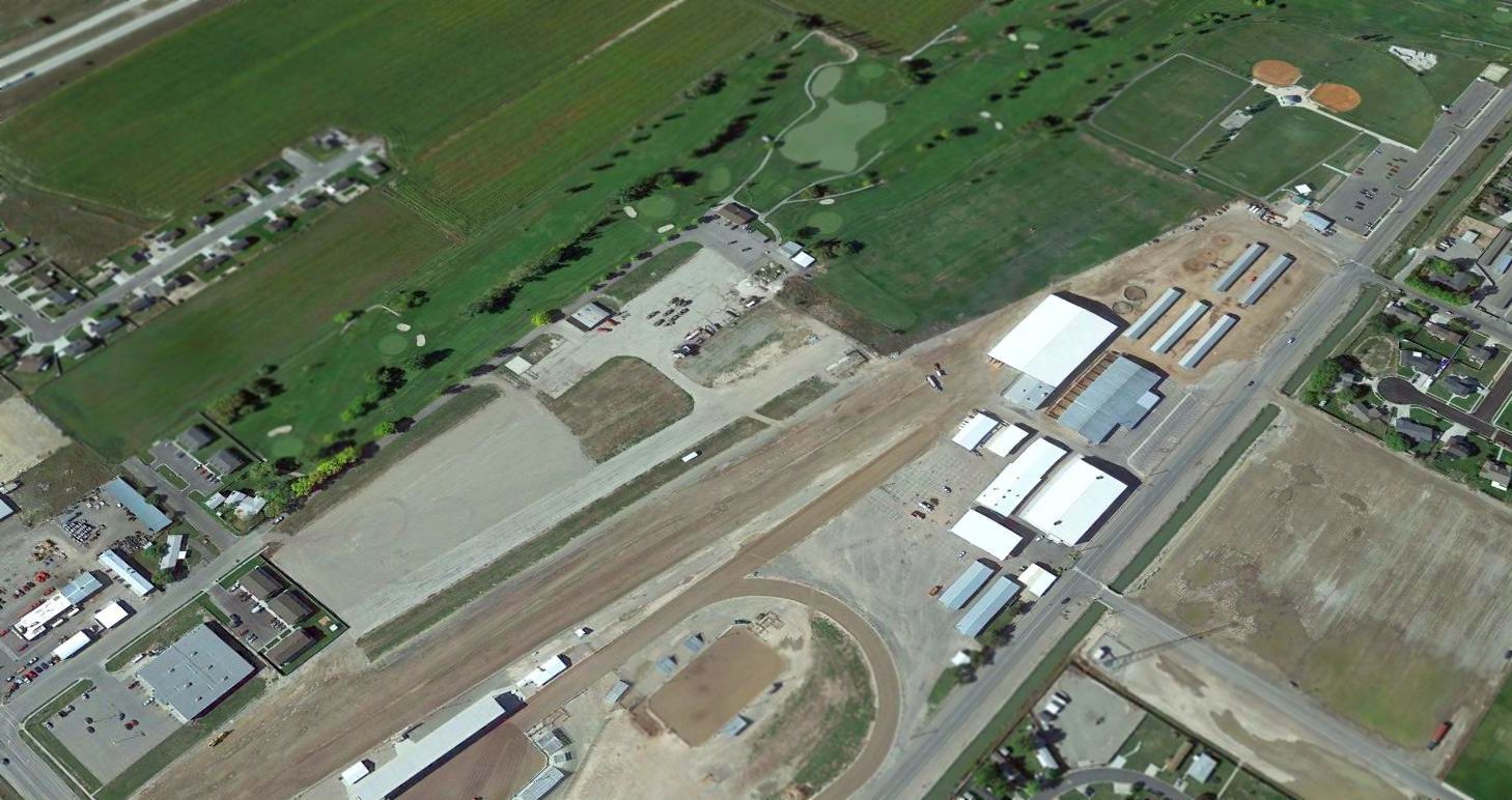
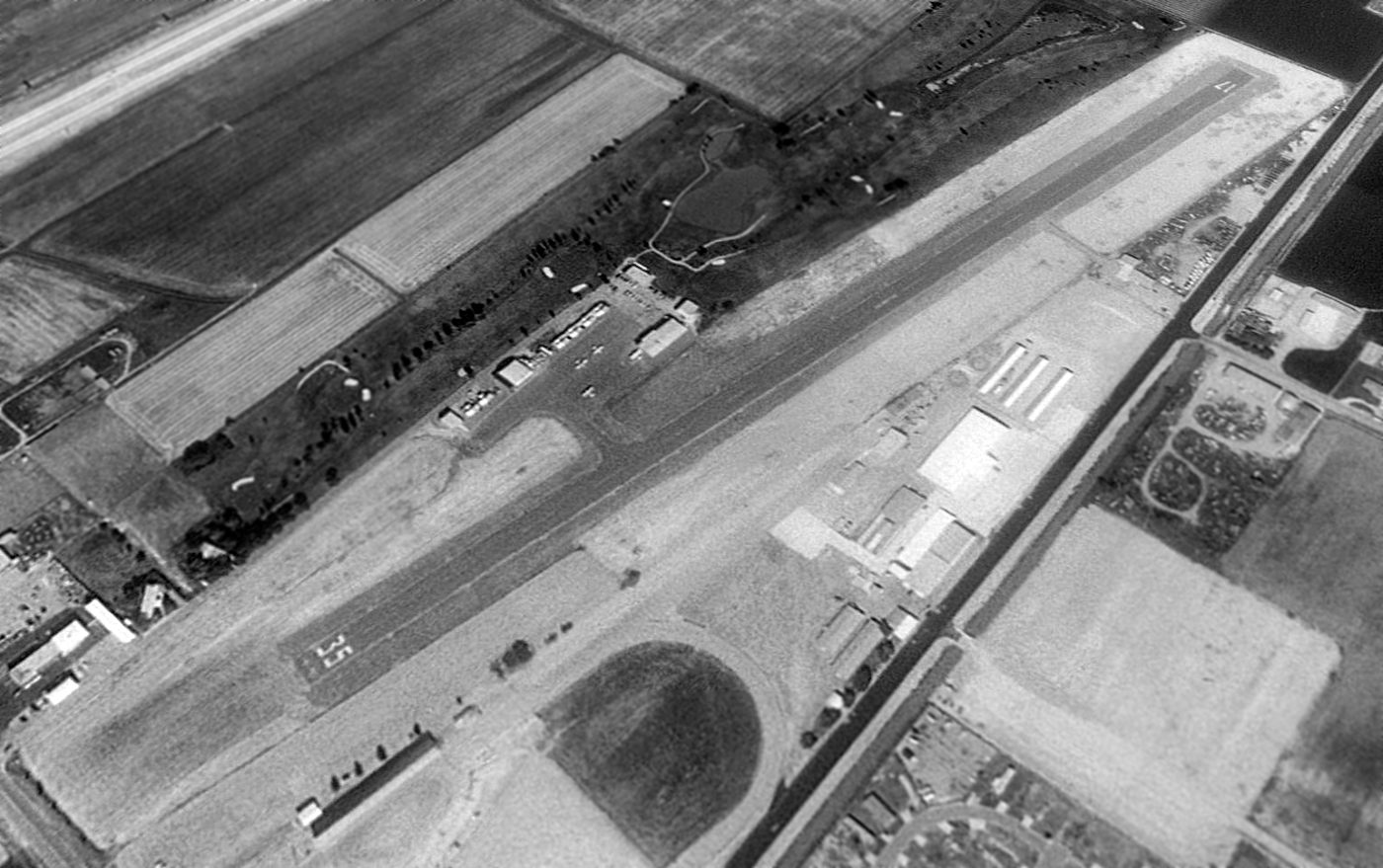
A 2014 aerial view looking northwest showed that the northern half of the Tremonton runway had been removed to make way for a golf course.
The southern half of the runway remained intact, and at least one hangar remained standing on the west side of the runway segment, with “Closed” painted in yellow letters on its roof.
The site of Tremonton Municipal Airport is located northwest of the intersection of Route 30 & North 6800 West.
Thanks to Chris Kennedy for pointing out this airfield.
____________________________________________________
Or if you prefer to contact me directly concerning a contribution (for a mailing address to send a check),
please contact me at: paulandterryfreeman@gmail.com
If you enjoy this web site, please support it with a financial contribution.
____________________________________________________
This site covers airfields in all 50 states.