
Abandoned & Little-Known Airfields:
Southwestern Utah
© 2002, © 2025 by Paul Freeman. Revised 8/23/25.
This site covers airfields in all 50 states: Click here for the site's main menu.
____________________________________________________
Please consider a financial contribution to support the continued growth & operation of this site.
Hurricane Mesa Airport (revised 11/17/24) - (Original) St. George Municipal Airport (revised 8/23/25)
____________________________________________________
Hurricane Mesa Airport, (UT27), Hurricane Mesa, UT
37.25, -113.208 (Northeast of Las Vegas, NV)
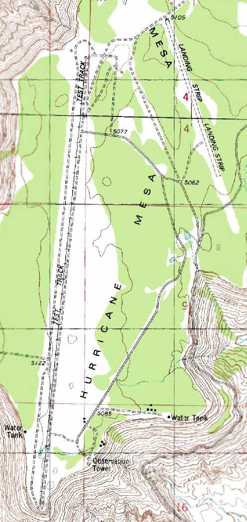
A 1956 aerial view looking northwest at the Hurricane Mesa test track (courtesy of Tim Tyler).
After the end of WW2, the advent of jet propulsion in military aircraft dictated the need for more sophisticated escape systems,
capable of safely extracting a pilot from high-speed aircraft.
In 1953 the Air Force awarded a $2 million contract to the Coleman Engineering Company of Torrance, CA,
to construct the Supersonic Military Air Research Track to test ejection seat systems.
The Air Force selected the flat, arid Hurricane Mesa in southern Utah as the location for the facility.
The location proved to be ideal.
The region's mild weather allowed year-round testing, the mesa's flat bedrock provided a secure anchor for the track,
its 1,500' drop into the Virgin River Valley was perfect for the planned tests
(in which test items would be propelled off the edge of the mesa), and the Virgin River supplied all the necessary water.
A 1953 aerial photo & the 1954 USGS topo map did not depict anything at the Hurricane Mesa site.
Coleman Engineering began construction of the facility during the summer of 1954.
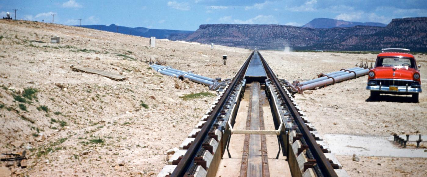
The track consisted of 12,000' of continuously welded, heavy-duty rails
that formed the longest rocket research track in the United States to that date.
The entire facility included the track, launching pad, crew shelters, camera towers, rocket storage depots, water system,
power system, communication system, security facilities, administration building, and a shop building.
According to Jack Reed's “Chronology of Hurricane Mesa Test Facility” (courtesy of Tim Tyler), Coleman's first test was run on 7/8/55.
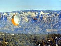
Testing at the site typically involved hurling a rocket sled, carrying a seat with a dummy known as "Hurricane Sam" strapped to it,
along the track at a speed of 1,050 mph (Mach 1.3).
"Sam", in actuality, was a highly instrumented anthropoid simulator with electronic equipment & a radio connected to it.
Just before reaching the edge of the cliff the ejection mechanism fired,
flinging the dummy over the precipice where its parachute opened & it floated to the valley floor.
In one series of tests "Hurricane Sam" was replaced by apes to determine the effects of ejection on live beings.
The earliest depiction which has been located of the Hurricane Mesa test track was a 1956 aerial view (courtesy of Tim Tyler).
It did not yet depict any airfield at the site.
The 1956 USGS topo map depicted neither the test track nor the airfield.
By 1958 Coleman Engineering had begun using the track for other tests,
including the launching of missiles from the rocket sled at targets 75 miles away.
At one point Coleman even set a world land speed record
when the 9,400-pound sled reached a speed of 1,800 mph.
Eventually the Air Force allowed different aircraft companies to test their equipment at the Hurricane Mesa site,
and many of Coleman Engineering's innovations were adopted by various industries.
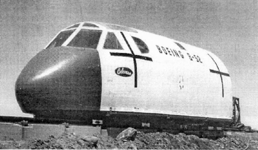
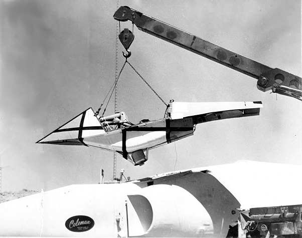
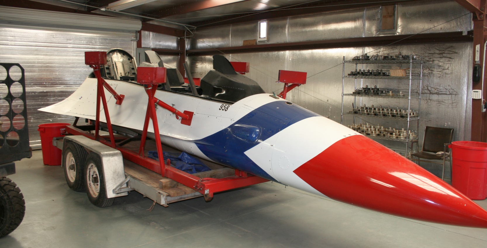
A circa 1955-61 photo of a Coleman test nose section of a Boeing B-52 bomber at the Hurricane Mesa test track (courtesy of Tim Tyler).
A 5/10/59 photo of Coleman's UT test track by Norvin Alcorn (courtesy of Steve Alcorn).
According to Steve Alcorn, “My dad, Norvin Alcorn, worked on the Coleman test track in Utah during the late 1950s.”
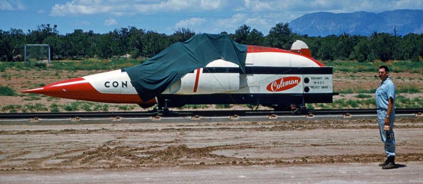
A 5/10/59 photo by Norvin Alcorn of a Convair F-102 Delta Dagger test fuselage on the Coleman's UT test track (courtesy of Steve Alcorn).
The September 1960 Grand Canyon Sectional Chart did not yet depict any airfield at Hurricane Mesa.
A 1960 aerial photo depicted the Hurricane Mesa test track, but the adjacent airfield had not yet been added.
A 1/25/61 photo of an unidentified sled test at Coleman's Hurricane Mesa facility (courtesy of Louis Ayala).
Louis Ayala reported, “I lived just a few minutes from the Coleman Engineering Office in Torrance.
One of my cousins was making a delivery to a local landfill & a photo blew across his path while he was unloading.
He picked up & saw a test-sled. He was curious about the photo & kept it. The photo was taken near the end of the Coleman tests.”
According to Johan Gustafsson, “The photo depict the test sled used when testing out the XB-70 Valkyrie escape capsule,
which was an improvement of the B-58 Hustler escape capsule.”
In the 6 years of Hurricane Mesa's early operation some 334 tests helped the Air Force to standardize its ejection systems
and perfect a seat that made emergency escapes much safer for American pilots.
According to Jack Reed's “Chronology of Hurricane Mesa Test Facility” (courtesy of Tim Tyler),
Coleman's last of 334 tests was run on 12/6/61, and the Air Force ceased operations on 12/30/61.
No airfield was yet listed at the Hurricane Mesa site in the 1962 AOPA Airport Directory.
According to Jack Reed's “Chronology of Hurricane Mesa Test Facility” (courtesy of Tim Tyler),
the track & facility were bought by Stanley Aviation Corporation of Denver in 1963.
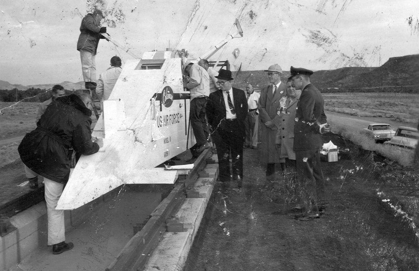
An undated photo of a prototype of a Stanley supersonic escape capsule,
being loaded into what appears to be an F-102 Delta Dagger nose section (with a “Coleman” label), presumably at Hurricane Mesa.
According to Tom Beamer, Bob Stanley had been the Vice President of Engineering at Bell Aircraft,
participating in many flight test & engineering programs including the Bell X-1 & X-2 aircraft.
The Stanley company designed & built many diverse products prior to entering into the escape & egress engineering field.
Stanley Aviation created many innovations in the egress field,
including Automatic Gas-Operated Safety belts, canopy jettisoning systems,
downward ejection seats, upward ejection seats, supersonic ejection capsules, and prototype ejection systems.
Aircraft fitted with Stanley egress equipment included the B-47, RB-47, XB-52, RB-66,
XF-104, F-104, YB-47, FJ-2, F-106A, F4H, P6M, B-58, and other prototypes.
One particularly advanced Stanley design was the Stanley Supersonic Capsule,
originally developed for the Convair B-58 Hustler, but also tested for adaptation to other aircraft (including the F-4).
At some point between 1962-65, Stanley developed an airfield at the Hurricane Mesa site.
The earliest reference to an airfield at the site came from John Lowry.
He recalled, “I had the opportunity to land & take off from that airport with Bob Stanley in July 1965.
Bob Stanley was a river rat and he & my father ran many of the rivers of the Southwest during the 1960s.
My father loved the outdoors & because he was an excellent outdoor cook Bob wanted him on the trips.
In July we had just finished riding the Colorado through the Grand Canyon
and Bob stopped at Hurricane Mesa to pick up a camera & equipment to take back to Denver.
I remember the runway as unpaved with a road barrier at the end.
We had a great time looking around the mesa & its rocket sled track.
Bob used old jet engines to propel the sled.
I would like to have seen a test, but I don’t think anything was planned.
He only had one maintenance man on the mesa at the time.
Bob had the Aerocommander fully loaded & I didn’t think we were going to get off the ground before hitting the barrier.
The neat aspect of the takeoff was as soon as you left the ground
you passed over the edge of the mesa & were immediately 1,500 feet in the air.”
According to Tim Tyler, “The founder of Stanley Aviation was a retired Naval Aviator & active civilian pilot,
and with company headquarters in Colorado, the Hurricane Mesa Test Facility landing strip is thought to have been established in the mid-1960s
as an expedient way for Bob Stanley to get back & forth between the Test Facility & his company's ejection seat factory in Aurora CO.
It was originally about a 4000' unpaved landing strip.”
According to Jack Reed's “Chronology of Hurricane Mesa Test Facility” (courtesy of Tim Tyler), Stanley's first test was run on 5/29/65.
Hank Pesch recalled, “I worked for Stanley Aviation from 1966-79.
When the Air force was ready to mothball the site in the early 1960s
Stanley Aviation leased the site from the government.
Stanley used the site from the mid 1960's to the late 1970's
to test & qualify the Yankee Escape Systems & its various derivatives.
The Yankee Escape System was used primarily on A-1E, A-1H/J and T-28 Trojan aircraft during the Vietnam conflict.
Stanley also developed prototype Yankee Escape Systems
for the Navy's A3B & EA-6B aircraft & the Army's Mohawk aircraft.
Stanley also developed a derivative of the Yankee Escape System
called the Away Escape System which was installed on the original Airbus test aircraft
for a method of crew escape if something went wrong during deep stall test.
The Away System provided a means of escape for up to 6 people on the test aircraft.
The Away System was also proposed for the Space Shuttle
by the company that bought the rights to all of Stanley's escape systems after his untimely death.
Unfortunately the system not accepted by NASA
which instead opted for the extendable barber pole which is on the Space Shuttle today.
All high speed testing for these systems was done at Hurricane Mesa.”
Hank Pesch recalled, “As for the development of the airfield at Hurricane Mesa,
Stanley had a fleet of company aircraft that were flown from Denver to the test site on a regular basis.
The aircraft shuttled personnel & equipment to support test operations.
The airfield was created so that the aircraft could land directly at the site
rather than having to land at Saint George or the local airport at the town of Hurricane.
Stanley aircraft included a Aerocommander 500 nicknamed the Blue Goose because of it's unique color,
two T-6 Texans, a T-28A and a Douglas A-26.”
The earliest depiction which has been located of the Hurricane Mesa airfield
was on the 1965 Grand Canyon Sectional Chart (courtesy of Chris Kennedy).
It depicted Hurricane Mesa as a private airfield having a 4,000' unpaved runway.
The earliest photo which has been located of the Hurricane Mesa Airfield was a 1967 aerial view.
It depicted a single unpaved northwest/southeast runway, located to the east of the test track.
The 1971 Las Vegas Sectional Chart (courtesy of Vince Granato)
depicted Hurricane Mesa as a private airfield with a 4,000' unpaved runway.
The earliest photo which is available of the Hurricane Mesa Airfield was an 8/27/73 USGS aerial view.
The single unpaved runway appeared to be the only aviation infrastructure at the site - there did not appear to be any ramp or hangars.
Hank Pesch recalled, “The airfield started out as unpaved
but was paved in 1975 to accommodate the A-26 which Stanley bought that year.”
USGS topo map 1980.
According to Jack Reed's “Chronology of Hurricane Mesa Test Facility” (courtesy of Tim Tyler),
the track & facility were bought by Stencel Aero Engineering of Asheville, NC in 1981.
Stencel's first run was 10/29/81.
The 1982 AOPA Airport Directory (courtesy of Ed Drury)
described Hurricane Mesa Airport as having a single 5,000' asphalt Runway 15/33.
The remarks said, "Private. Use at own risk."
According to Jack Reed's “Chronology of Hurricane Mesa Test Facility” (courtesy of Tim Tyler),
Stanley's last of 299 tests was run on 11/11/83,
and Stencel's last of 73 tests was run on 2/27/86.
Talley Industries merged Stencel Aero Engineering Corporation into Universal Propulsion Company at the end of May 1986.
UPCO's first test was run 7/1/86 and their last of 256 tests was run on 6/27/97.
In February 1998 Talley Industries sold UPCO to Carpenter Technologies.
UPCO under Carpenter's ownership first run was 3/11/98
and their last of 21 tests was run on 8/20/98.
Goodrich bought UPCO from Carpenter Technologies on 10/19/98.
UPCO's first test under Goodrich ownership was run on 2/4/99.
Universal Propulsion describes itself as "the only US ejection seat manufacturer offering complete aircrew escape systems,
including canopy removal, sequencing systems & the ejection seat."
The Universal Propulsion web site describes the track as "fully capable of handling propulsion velocities exceeding supersonic.
No other domestic track can equal HMTT for remoteness, privacy, security & on site facilities.”
Tom Kramer recalled, “I used to fly from Fullerton, CA up to Cedar City, UT
and would cruise right by the mesa & the track at about 7,500+ feet.
Seeing only occasional lights up there but no apparent life,
one time I decided to fly over the several miles off of the airway
and do a few low passes over the facility down to a few hundred feet off the top.
I saw that even though the track was there, it was unusable due to a huge pile of earth mounded up in the middle.
I thought of touching down on the airstrip but since I was uncertain it was totally abandoned, I passed.”
Tom continued, “On one later trip, when we drove over to Zion,
I found the 2-lane entry road & drove up to the top of the mesa.
Even though the road looks nice, paved & passable from the bottom, part way up,
sections of it are missing from landslides & it is down to one lane (or less).
I was able to squeeze by in my Toyota Celica with my wife commenting on my sanity.
At the top, you drive a few hundred yards into a pine forest & there is a huge gate,
which was locked with a chain & huge rusted padlock.
At one time, it was an automatic gate as evident by the power gate swing mechanism.
Barbed wire topped fencing goes off in each direction. It looked maintained.”
An undated view of the gate to the Hurricane Mesa Test Track.
An undated aerial photo of the Hurricane Mesa Test Track & Airport.
An undated photo of a test article being retarded by a parachute at the Hurricane Mesa Test Track.
Test cockpit sections which have been seen at Hurricane Mesa include cockpits
of an F-15 Eagle, A-4 Skyhawk, and F-102 Delta Dagger.
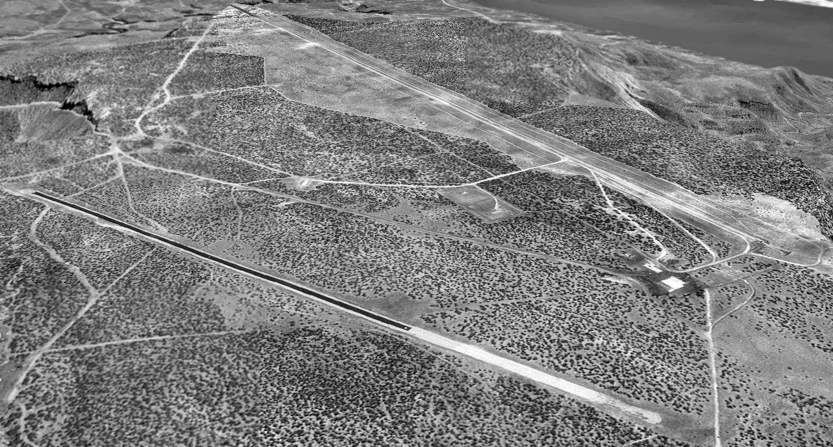
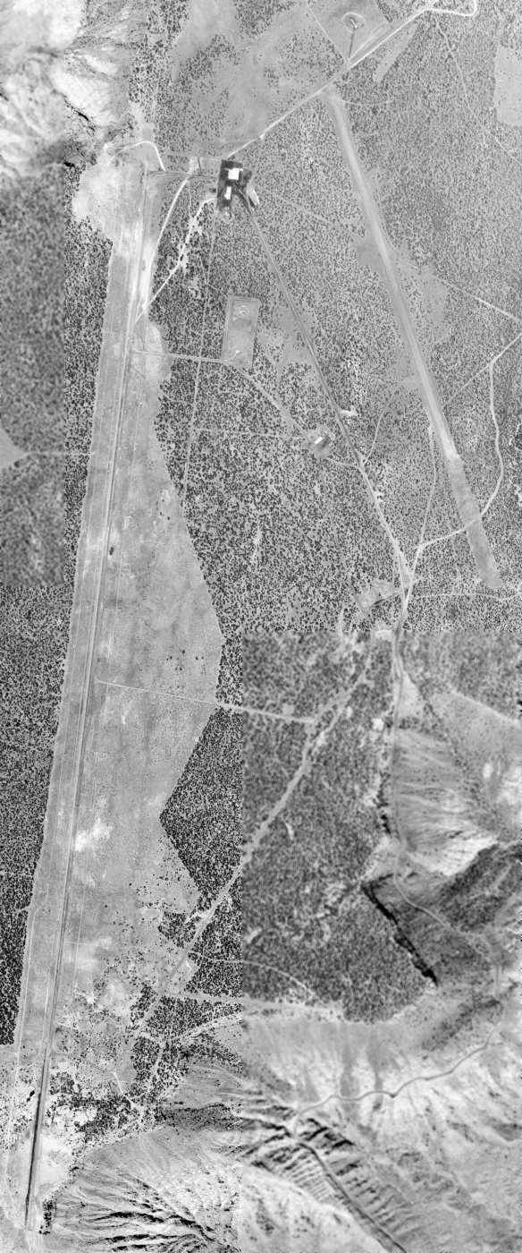
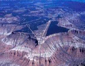
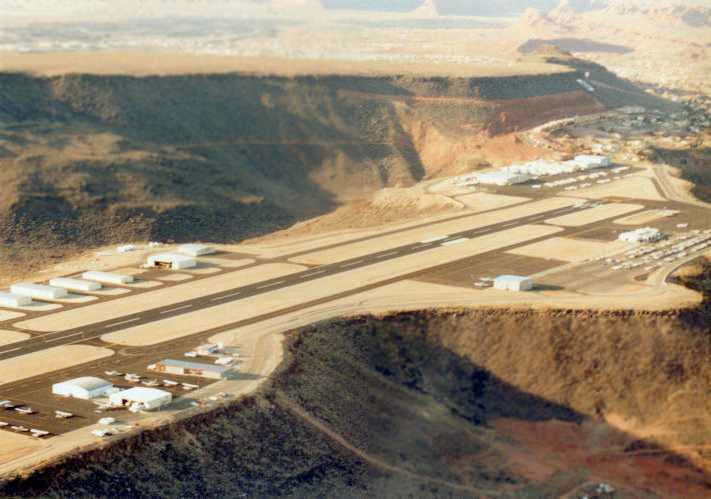
A 1993 USGS aerial view looking southwest at the Hurricane Mesa Test Facility, with the abandoned runway in the foreground & the test track in the background.
The single runway appeared to be the only aviation infrastructure at the site. There did not appear to be any ramp or hangars.
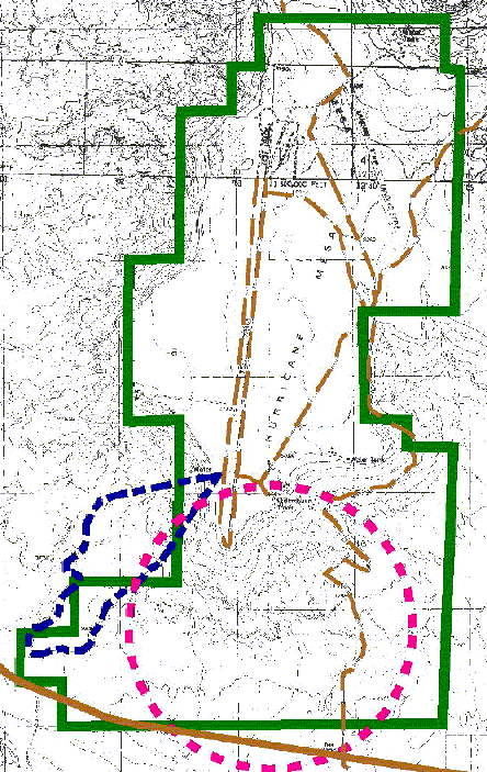
the "R & D Range" (blue), and "OB / OD Range" (pink).
As of 2003, the Airport/Facility Directory data for Hurricane Mesa Airport
described it as a private airfield consisting of a single 5,000' gravel Runway 15/33.
The owner was listed as Universal Propulsion Company,
and the remarks said, "Airport hazardous due to winds."

A 1/22/06 view along the Hurricane Mesa test track.
As of 2007, the owner of the Hurricane Mesa Test Facility, formerly known as Universal Propulsion Company,
was known as Aircraft Interior Products Propulsion Systems, a wholly owned subsidiary of Goodrich Corporation.
Hurricane Mesa is described by the company as “The nation's only privately-owned supersonic test track.
Located atop Hurricane Mesa, the 12,000' track is fully capable of handling propulsion velocities up to supersonic.
The track level is at 5,100' MSL with the muzzle terminating at a 500' vertical cliff.
The sloping terrain of the mesa provides an additional drop of 1,000' to the valley floor below.
Hurricane Mesa Test Facility has been used as a shooting location for several motion pictures.
The rugged & picturesque locale has provided a backdrop for scenes from 'The Car', 'Octopussy', and 'The Electric Horseman'.”
As of 2010, the Hurricane Mesa site was still labeled on street maps as “U.S. Air Force Proving Grounds”,
most likely an indication of the property's ownership (as Universal evidently leases the site from the government).
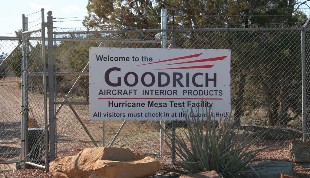
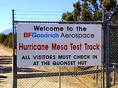
A 3/27/10 photo by Tim Tyler of the sign on the gate of the Hurricane Mesa Test Track.
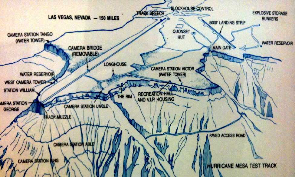
A 2012 photo by Tim Tyler of an undated map of Hurricane Mesa from “a display on Washington County aviation history that's at the new SGU Airport.”
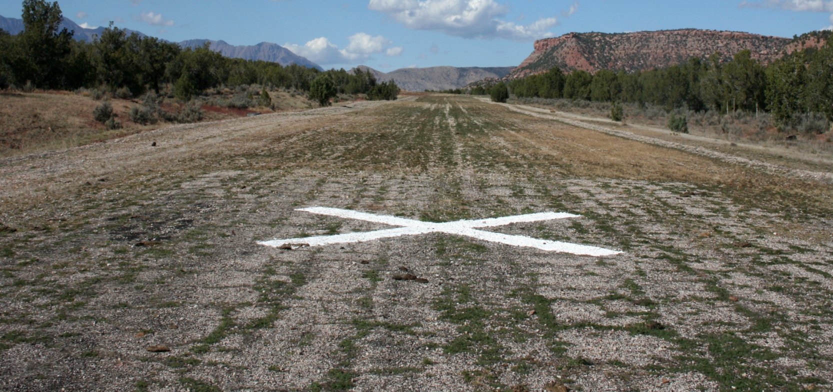
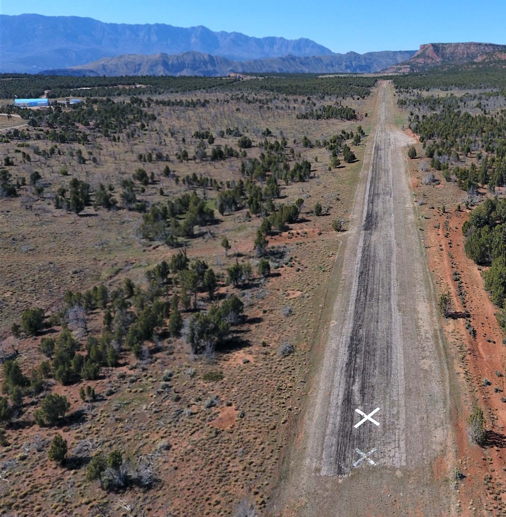
A 2012 photo by Tim Tyler looking north-northwest along Hurricane Mesa's paved runway, showing the closed-runway X symbol.
Tim noted, “Each end of the paved runway have a gravel overshoot area.
The paved runway seemed to be in fair condition, despite not longer being used.”
Tim Tyler reported in 2012, “As of Fall 2012, the landing strip is now longer used & hasn't been in at least several years.
However, UTC Aerospace Systems still lists a 6,000' paved runway as a benefit of their test facility atop Hurricane Mesa.
However, a video promoting HMTF only indicates using Las Vegas or St George Airports.
The former airfield is not at all visible from the public BLM or USFS roads, due to trees, but it still shows up well on aerial imagery.
I rode my trail motorcycle up to the site with the expectation that I would be able to find access to the runway area,
but due to barbed-wire fencing, I had to park the motorcycle & walk a couple dozen yards to the airfield.
I then ended up spending about 2 hours walking up & down the entire airfield.
I'm not sure who actually owns the former airfield now -
I assume Goodrich/Universal would have terminated their lease on the land in order to save money,
and that the land is now BLM property, like most of the surrounding area.”
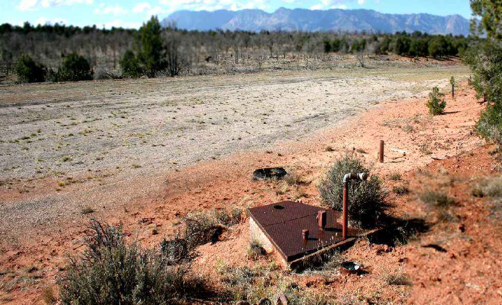
A 2012 photo by Tim Tyler looking west at what is presumed to be an aircraft refueling station along the east side of the midpoint of Hurricane Mesa's runway.
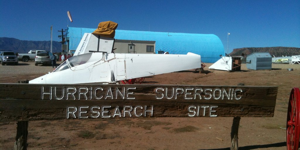
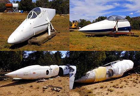
A 10/19/12 photo by Tim Tyler of an A-4 Skyhawk test fuselage at the “Hurricane Supersonic Research Site”.
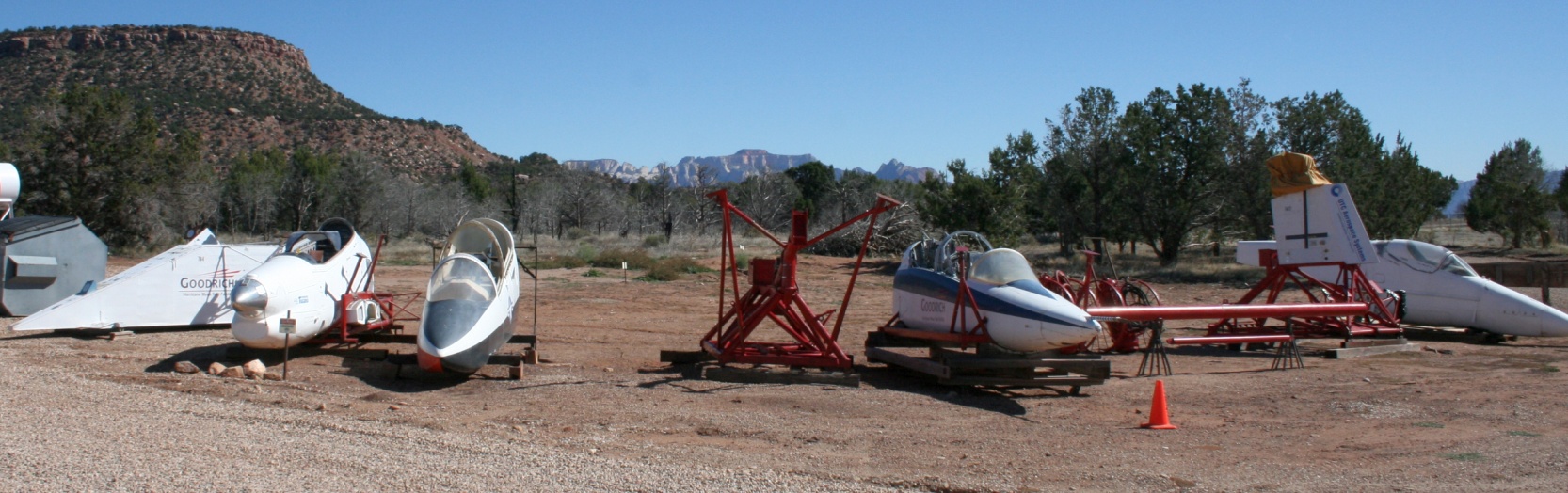
A 10/19/12 photo by Tim Tyler of a variety of military aircraft test fuselages at the Hurricane Supersonic Research Site.
A 10/19/12 photo by Tim Tyler of a F-16 Falcon test fuselage in Thunderbirds colors inside a workshop at the Hurricane Supersonic Research Site.

A 10/19/12 photo by Tim Tyler of a military aircraft test fuselage at the Hurricane Supersonic Research Site – was this an A-3 Skywarrior?
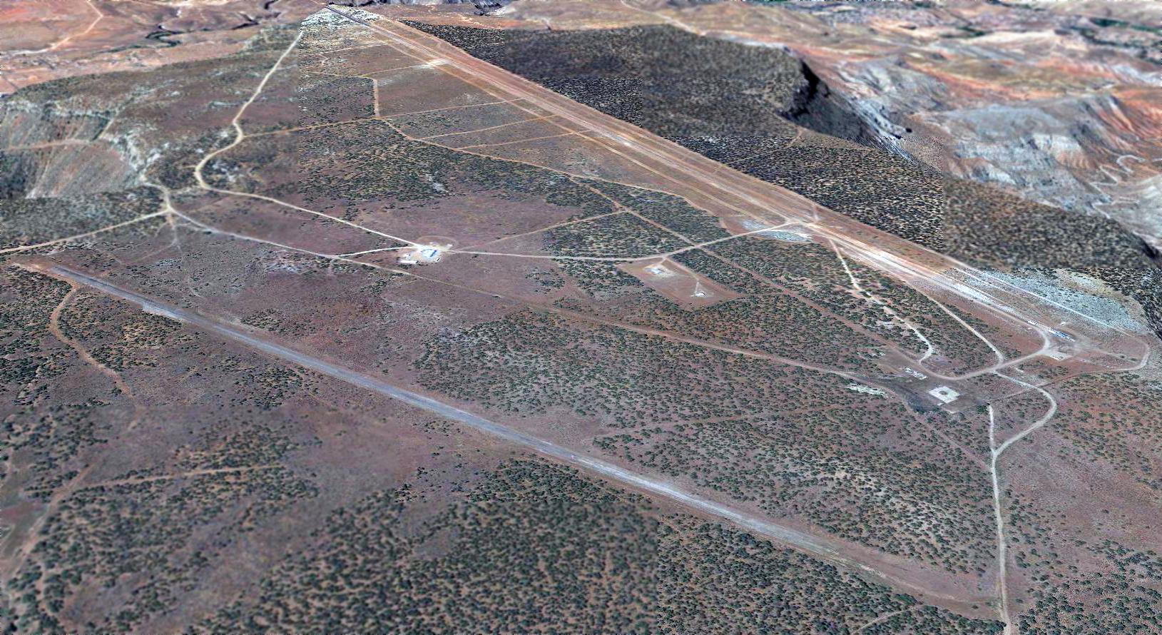
A 2017 aerial view looking southwest at the Hurricane Mesa Test Facility, with the abandoned runway in the foreground & the test track in the background.
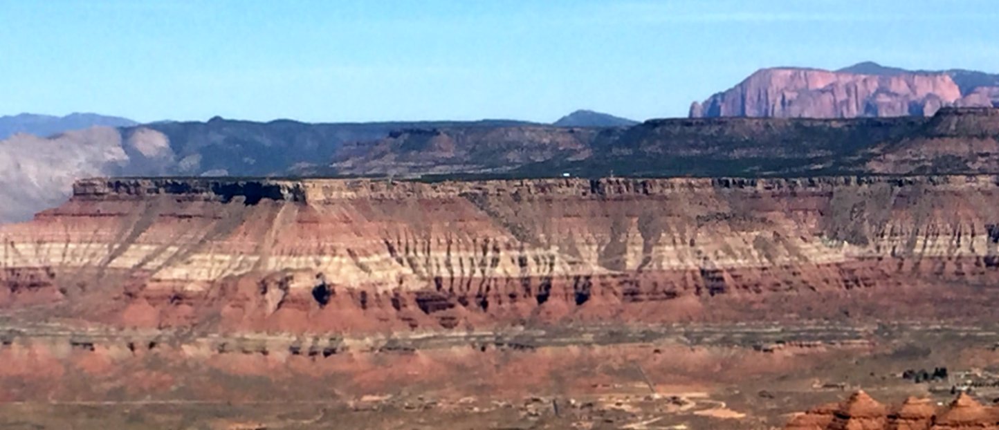
A 3/29/18 photo by Paul Freeman looking north at Hurricane Mesa, taken from across the valley from the top of Gooseberry Mesa.
A 4/14/18 drone aerial view by David Birkley looking northwest at the Hurricane Mesa Test Facility runway.
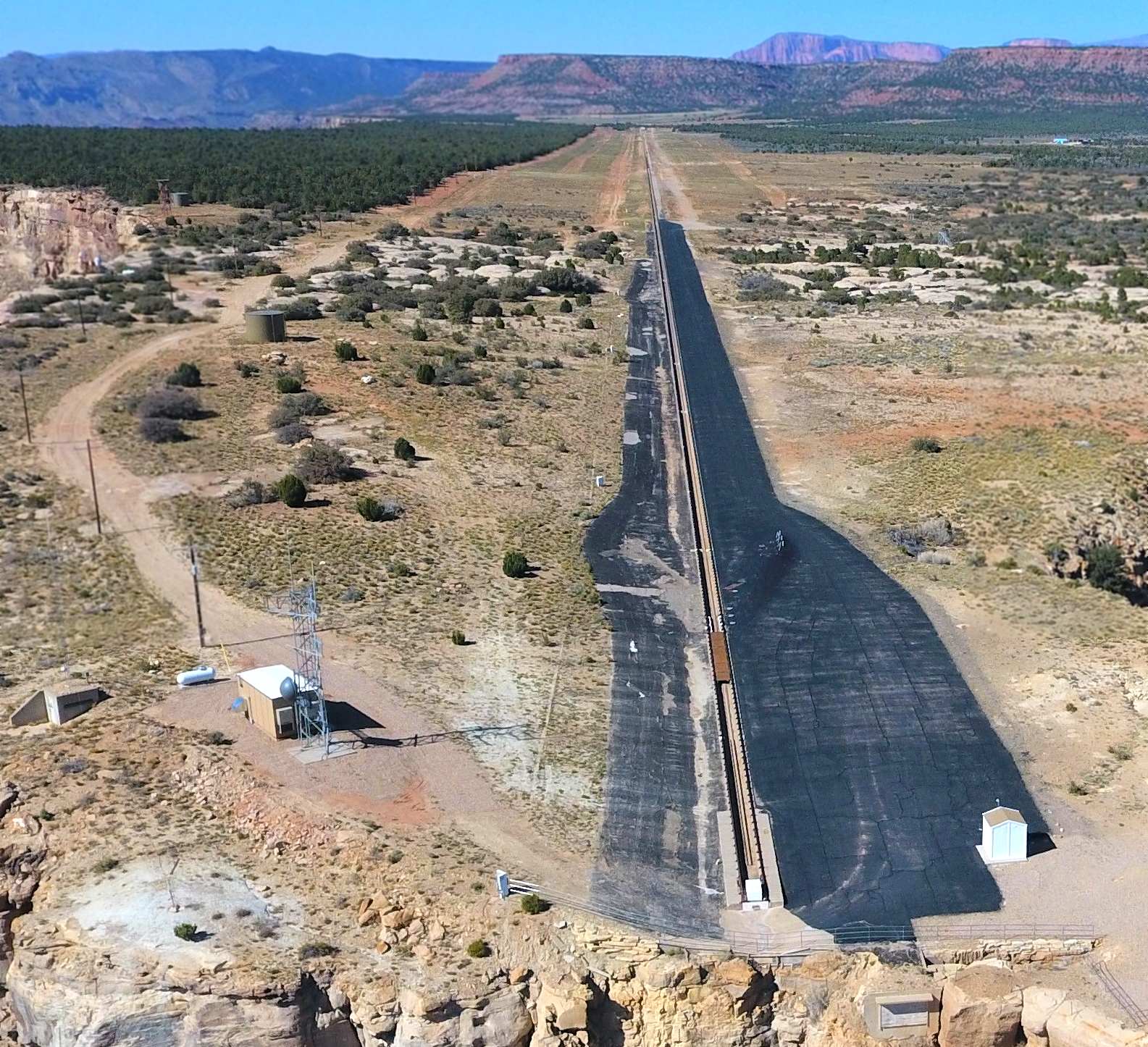
A 4/14/18 drone aerial view by David Birkley looking northeast at the Hurricane Mesa Test Track.
A 4/14/18 drone aerial view by David Birkley looking southwest at the Hurricane Mesa Test Track.
Craig Thompson reported in 2020, “Hurricane Mesa is now being operated by Alliant Techsystems (ATK Aerospace), a subsidiary of Northrop/Grumman.
The rocket sled facility has renewed activity.”

An 11/11/24 photo by Dan Blumel of the sign on the gate of the Hurricane Mesa Test Track.

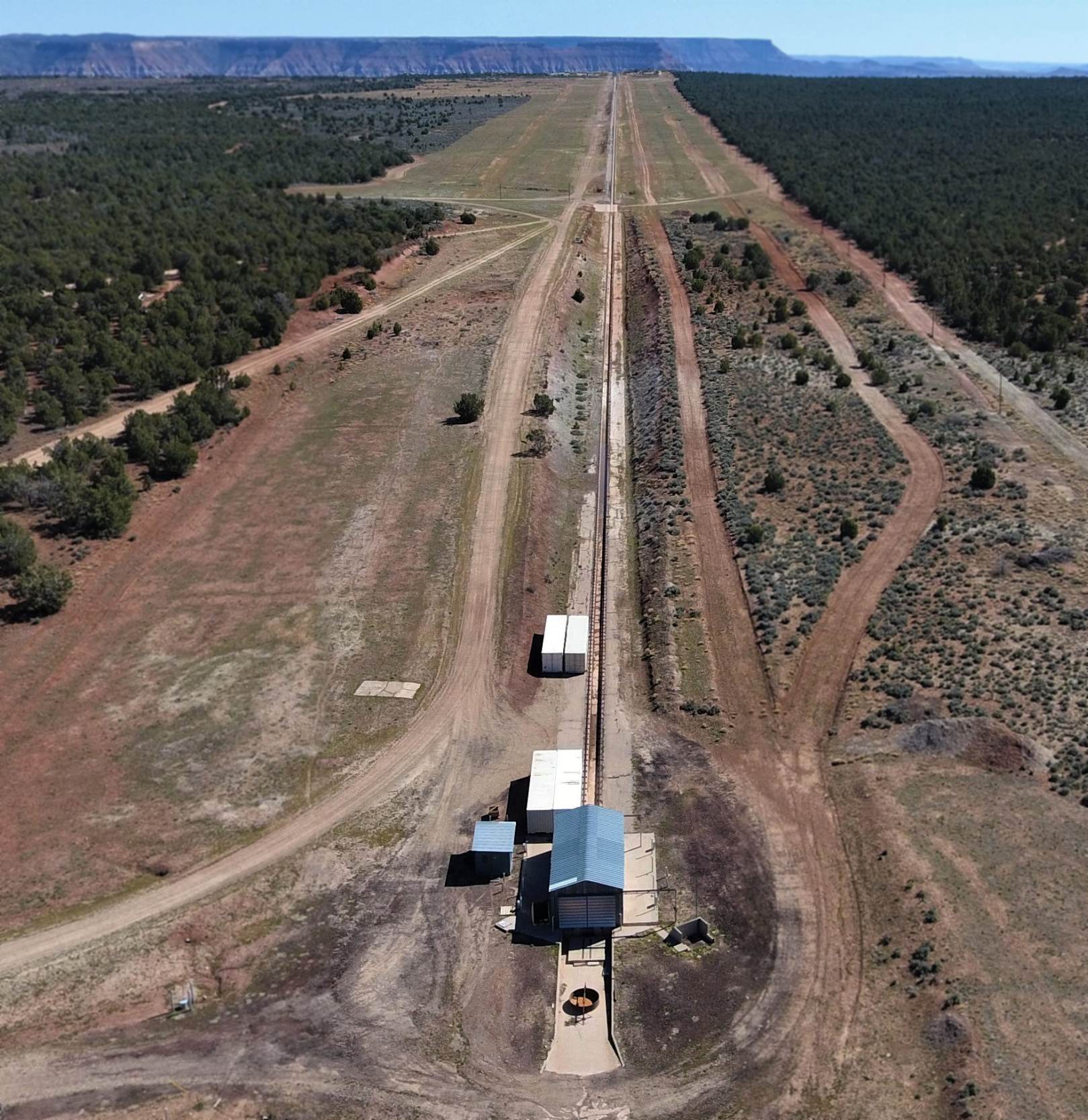
An 11/15/24 aerial view by Chris Terry looking southwest at the Hurricane Mesa Test Track.

An 11/15/24 aerial view by Chris Terry looking along the former Hurricane Mesa runway.

An 11/15/24 aerial view by Chris Terry of the collection of aircraft nose sections at the Hurricane Mesa Test Track.
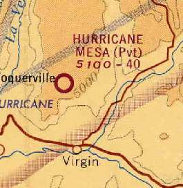
The Hurricane Mesa facility is located 5 miles north-northwest of Virgin, UT.
See also: http://historytogo.utah.gov/hurricsam.html
____________________________________________________
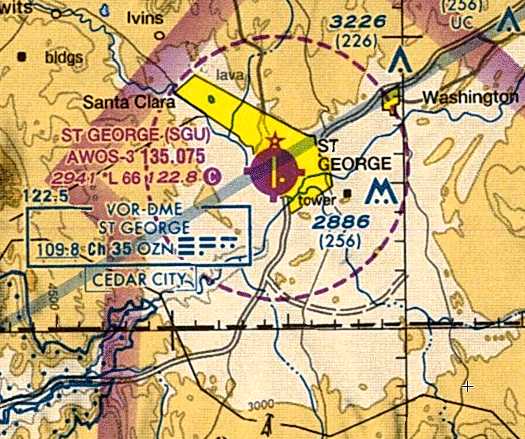
St. George Municipal Airport (original location) (KSGU), St. George, UT
37.09, -113.594 (Northeast of Las Vegas, NV)

The original St. George Municipal Airport, as depicted on the 1931 Rand McNally Air Trails (courtesy of Jonathan Westerling).
The original airport for the town of St. George was located adjacent to the southwest side of the town.
The date of establishment of the St. George Municipal Airport has not been determined.
The earliest reference which has been located of St. George Municipal Airport was in the 2/15/24 Commerce Department Airway Bulletin (courtesy of Jonathan Westerling).
It described St George as an 1,800' square emergency field.
The earliest depiction which has been located of St. George Municipal Airport was in the 1931 Rand McNally Air Trails (courtesy of Jonathan Westerling).
It described St George as the Commerce Department's Intermediate Field #34B, along the LA – Salt Lake Airway.
It was said to be an irregularly-shaped gravel field measuring 3,000' x 400'.
The earliest aeronautical chart depiction which has been located of St. George Municipal Airport
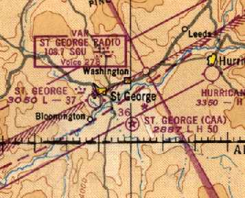
was on the December 1935 Grand Canyon Sectional Chart.
It also depicted the field as having Commerce Department Beacon # 37A.
The Airport Directory Company's 1937 Airports Directory (courtesy of Bob Rambo)
described St. George as the Department of Commerce's Site 34 along the Los Angeles – Salt Lake Airway.
It described the field as being located 1 mile southwest of the town,
consisting of a 34 acre irregularly-shaped field, containing a single 3,000' gravel runway.
St. George Airport was listed in The Airport Directory Company's 1938 Airports Directory (according to Chris Kennedy).
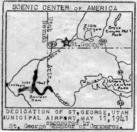
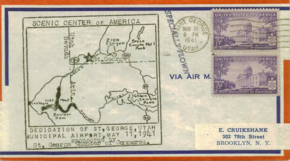
A postmark commemorated the 5/11/41 dedication of St. George Municipal Airport,
even though the airport had been in existence for at least 6 years by that point.
The earliest depiction which has been located of the original St. George Municipal Airport
was a 10/15/43 aerial view looking north from the 1945 AAF Airfield Directory (courtesy of Scott Murdock).
It depicted St. George as a single unpaved runway along a flat plateau, with a few small hangars along the southeast side.
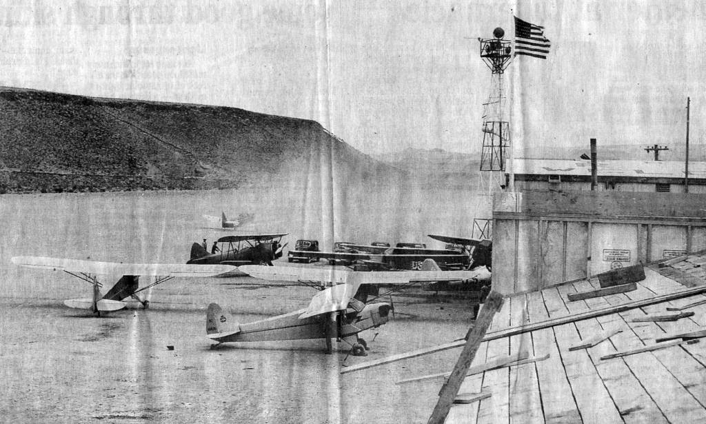
A WW2 era view of the “St. George Airport on the Black Hill” in its Civilian Pilot Training program days (courtesy of Tim Tyler),
showing a Piper Cub & several other light monoplanes & a biplane.
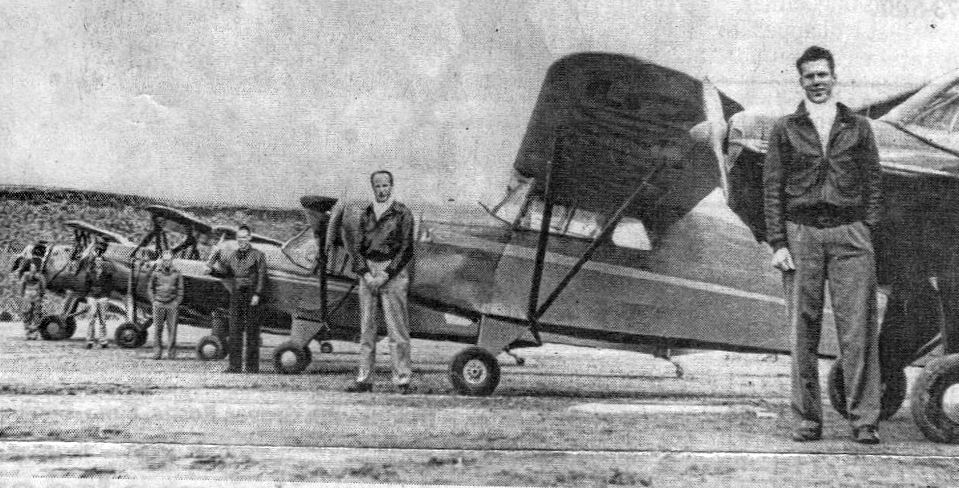
A WW2 era of instructors of St. George's Civilian Pilot Training program in front of their aircraft (courtesy of Tim Tyler).
The federal government decided to build an additional airport, 5 miles southeast of the town, in 1944.
In Dave Ulane's words, "The old St. George FAA airport was actually built
as a Civil Aeronautics Administration (CAA) Intermediate Airfield."
The 1945 AAF Airfield Directory (courtesy of Scott Murdock) described the St. George Municipal Airport
as a 120 acre irregularly-shaped site having a single 3,690' north/south gravel runway.
The field was said to have 2 wood & metal 60' square hangars,
to be owned by private interests, and operated by the City of St. George & private interests.
The original St. George Municipal Airport, as depicted on the September 1949 Great Salt Lake World Aeronautical Chart (courtesy of Donald Felton).

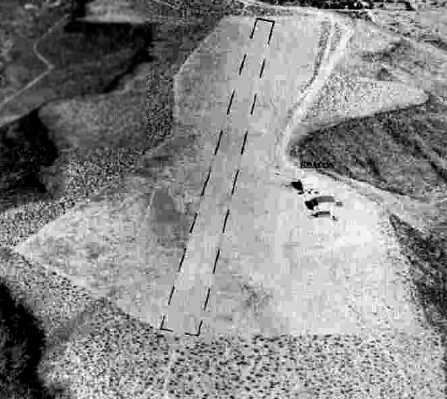
An 8/10/53 USGS aerial photo depicted St. George Municipal Airport as having its original north/south unpaved runway, along with a northeast/southwest unpaved runway which had been added at some point between 1943-53.
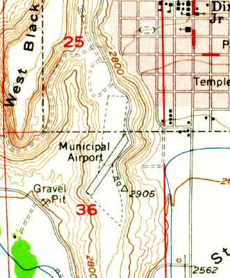
The 1954 USGS topo map depicted St. George Municipal Airport as having a single northeast/southwest runway, and 2 small buildings on the southeast.
The 1959 Grand Canyon Sectional Chart (courtesy of Chris Kennedy)
depicted the St. George Airport as having a single 5,100' paved runway.
The runway orientation was depicted as north/south, in contrast to topo map depictions.
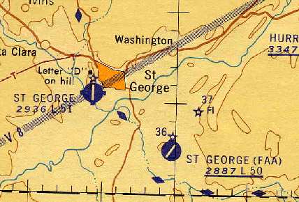
According to David Ulane, the FAA Airport to the southeast was closed in 1961.
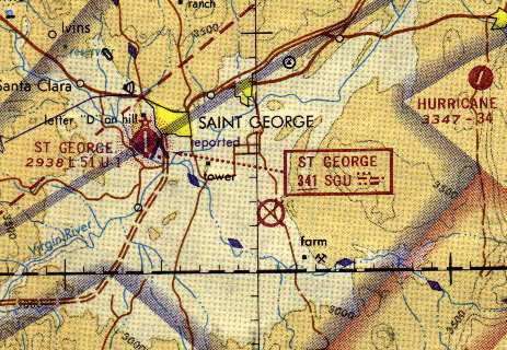
The 1971 Las Vegas Sectional Chart (courtesy of Vince Granato)
depicted St. George Airport as having a 5,100' paved runway.
The other (FAA) airport to the southeast was depicted as an abandoned airfield.
Chris Atkin's article “Farewell To An Old Friend – Another Airport Fades Away” in the 7/21/16 Air Facts Journal reported,
“I met St. George Airport in 1972, at the ripe old age of 6. I was deeply into aviation, with every Apollo and Skylab mission as a must-see.
When an airplane flew over, I would let the baseball fly over unheeded. That’s part of why I don’t do sports very well.
On each Saturday, after my chores were done, and sometimes before, I would hike up the mesa to the airport.
At that time, the FBO was mid-field, run by Sky West. I was welcome, as I was respectful of the wonderful residents there.
There was a yellow Grumman Traveler, called 'Yellow Bird' by my uncle.
Sky West had 5 airplanes at that time, and I was allowed to peer into the magic of the nacelles of the Chieftain.
One Saturday I was at the ranch with my grandpa, so I missed my trek. The staff at the FBO called my mom to check on me, and make sure I was okay.
I was welcomed & expected by them. I miss that at airports today.”
The 1977 USGS topo map continued to depict St. George Municipal Airport as having a northeast/southwest runway.
The 1981 USGS topo map depicted St. George's runway as being oriented north/south.
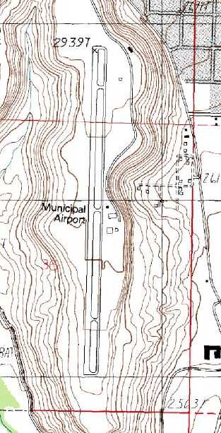
The 1986 USGS topo map depicted St. George Municipal Airport as having a single north/south paved runway with a parallel taxiway,
and a few small buildings on the east side.
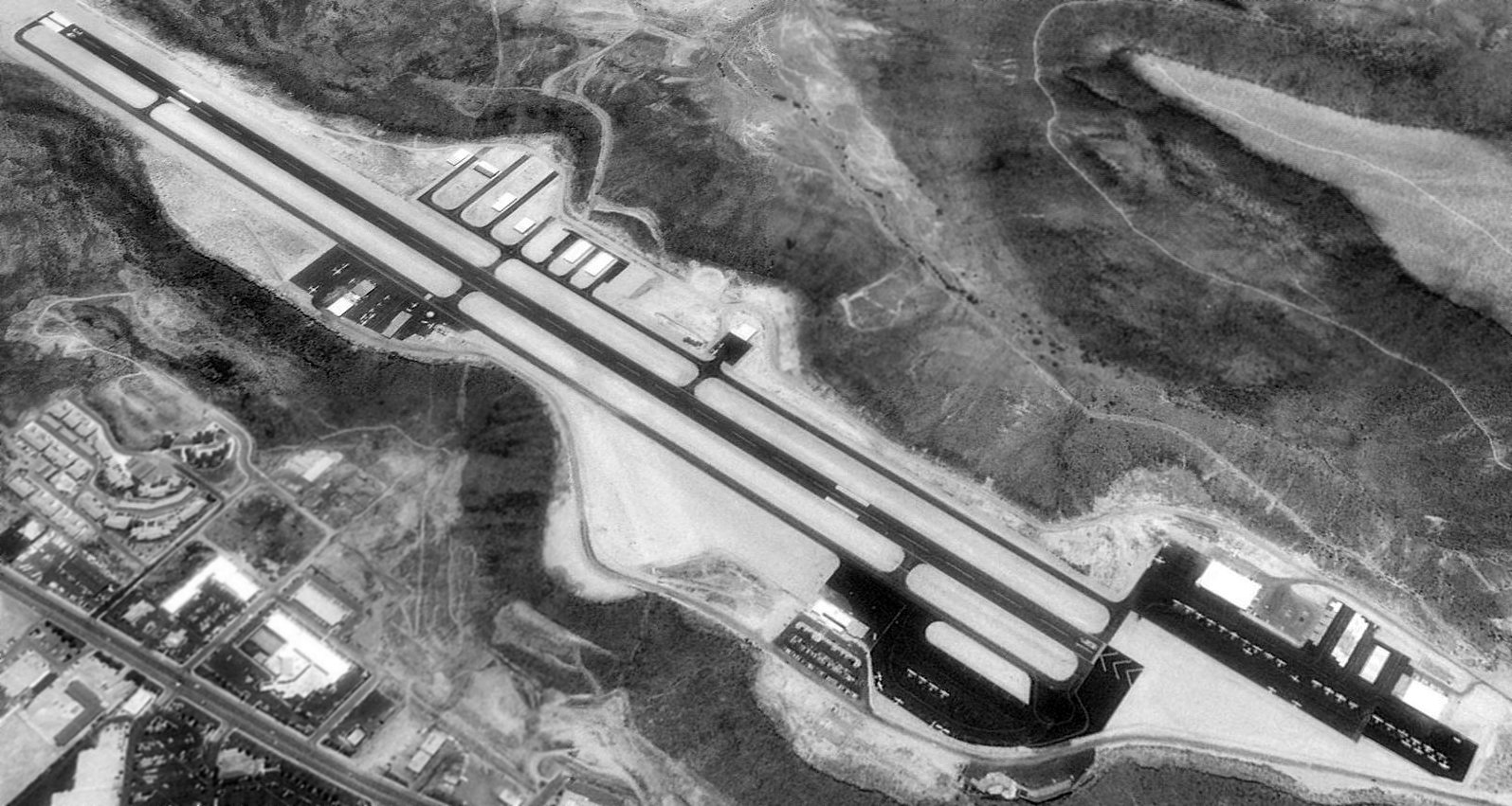
A 6/24/93 USGS aerial view looking southwest at the St George Airport showed a considerable number of improvements compared to the 1986 topo map,
including ramps and hangars on the northeast & northwest sides.
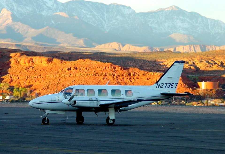
A beautiful March 2001 photo by Colin Abbott of a Piper PA-31-350 Navajo Chieftain at St. George Municipal Airport.
As described on the web site of the City of St. George, in an odd twist of fate,
the town planned to replace the airport next to the town by building a new field on the site of the abandoned FAA Airport:
"The existing site is too small: Space limitations at the current mesa-top location
prohibit needed expansion to accommodate large commercial service & commercial jets.
The Solution: The old CAA Airport site has been selected by the City of St. George
as the preferred site for a replacement airport."
David Ulane reported in 2003, "The City of St. George is indeed pursuing the construction of a new airport.
Our existing airport sits on top of the West Black Mesa right in town,
and is severely constrained by the geography of the mesa.
Our runway is too short, our taxiway & runway are too close together,
and we have virtually no room left for additional hangars or development.
We cannot accommodate regional jet airline service or larger general aviation jets at our present airport,
which is now surrounded by the City of St. George.
In 1998, the City selected the old CAA site as the most suitable for a replacement airport,
with the new Runway 4/22 planned to begin at the north end of the old CAA runway.
Too bad our City didn’t turn it into an airport back in 1961!
We are presently undergoing an extensive environmental study of the new airport,
which is expected to be operational in 2010.
At that time, the present airport will be redeveloped into residential use,
consistent with the surrounding area.”
David reported that at the current St. George Municipal Airport,
"In our airport terminal here, we have an excellent display about our area’s aviation history,
including the old 'FAA airport'."
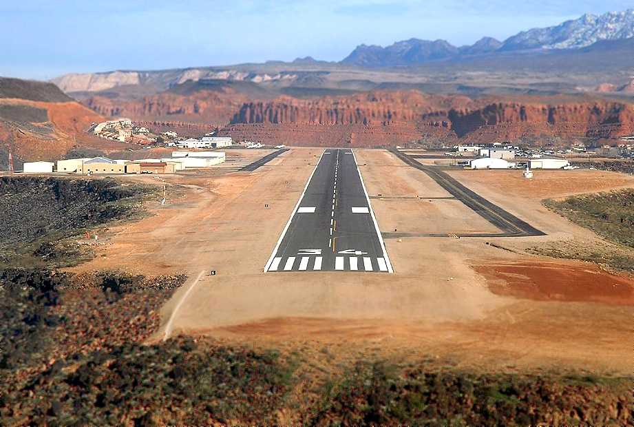
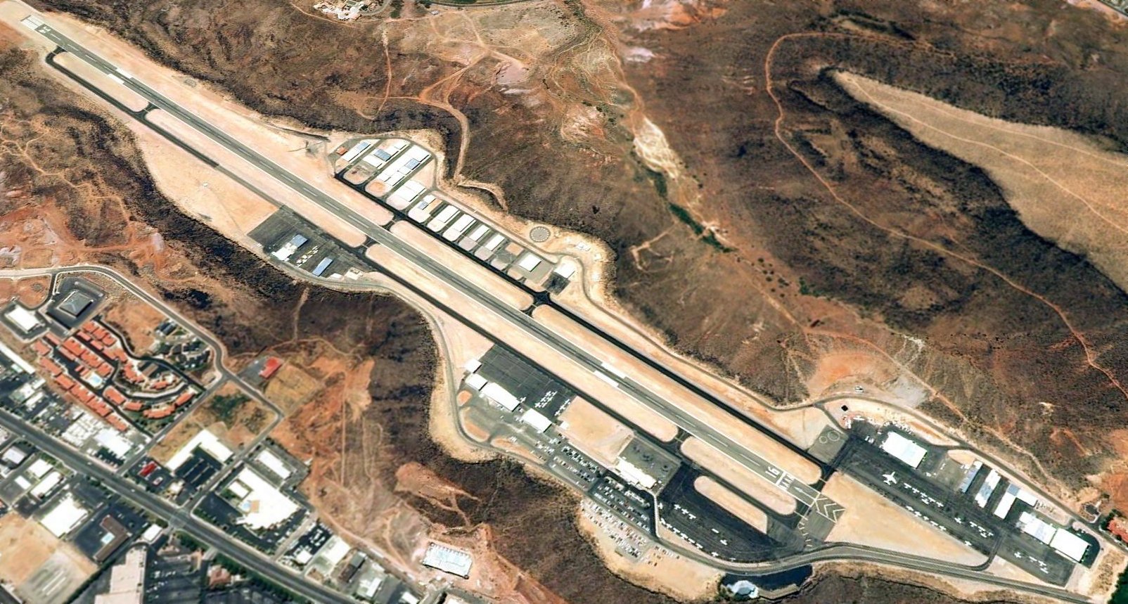
A beautiful 1/16/05 aerial view by Brett Wirick while on final approach to St. George's Runway 34.
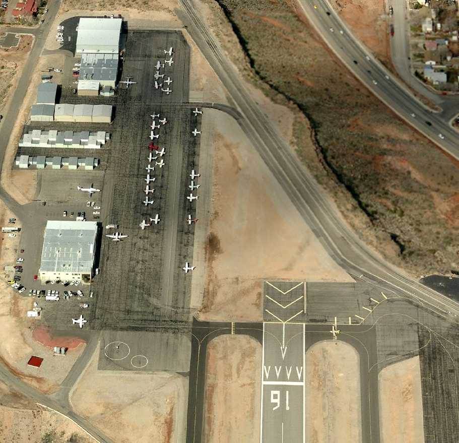
A circa 2006-2010 aerial view looking north at St. George's northwest ramp.
A 2009 or earlier aerial view looking northwest at St. George Airport, showing the sharp drop-off of the plateau.
The last photo which has been located showing the original St. George Municipal Airport in operation was an 8/28/09 aerial view looking southwest.
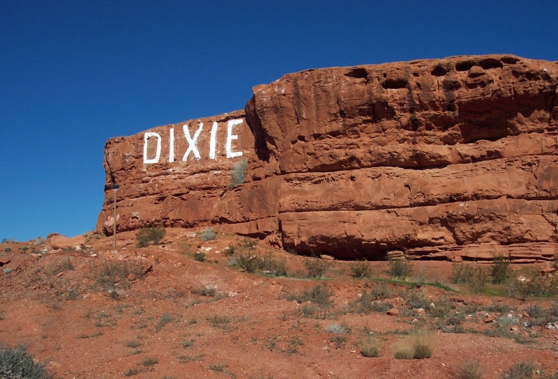
A 2010 photo by Chris Atkin of “Dixie” Rock, just off the St George Airport final approach..
Chris recalled, “Approaching the airport was done from over the Red Hill, with the DIXIE Rock seemingly right under the wheels.
In later years, I would extend my approach a bit in the summer to see the college girls sunbathing on the red rocks.”
Chris Atkin's 2010 Air Facts Journal article “Farewell To An Old Friend – Another Airport Fades Away” reported,
“Sky West has out-grown my friend, and a new airport has been built.
No longer will my friend, who today sits right in the middle of town, be able to challenge & welcome pilots from all over the world.
Like her or hate her, St. George was a young pilot’s friend.
So, today, we spent almost 2 hours flying to say goodbye to my old friend. She has grown up.
Once a single strip of blacktop, now she boasts a taxiway on each side of an extended runway, a terminal, and her own TSA presence.
The last may not be a huge plus, but he was good enough to let us back onto the ramp.
With the closure so close, the codes to the gate for transient pilots have been removed.”
Chris continued, “The first Sky West hangar, the blue one on the south end, is still there.
So is the 'new' Sky West hangar on the North end, but now it’s called the Jet Center.
As with any airport, airplanes of every type & state of repair line the ramp.
A Twin Commander with no wings sits on its belly on the north side, reminding me of the Mooney I used to play in by the blue hangar.
A 177RG has 'For Sale' flags flying from its prop, reminding me of the Cardinal I almost bought back in 1985, that was on the northwest ramp.
A Mooney with severe prop-rash told of a flight that ended about 2 feet too low.
My friend is going away. St George will have a new, larger, 'better' airport just 5 miles away, but never again will the magic of a 'carrier' landing be had after the 13th of January.
I had a lump in my throat when I told the very helpful lineman I had come to say goodbye to an old friend. He may not have understood.”
The last aeronautical chart depiction which has been located showing the original St. George Municipal Airport in operation
was on the August 2010 Las Vegas Sectional Chart.
The original St. George Municipal Airport (KSGU) closed on 1/13/11,
coincident with the opening of the new St. George Municipal Airport (KDXZ)
which had been built over the site of the old St. George FAA Airport to the southeast.
An article entitled “Old airport eerily quiet: City waiting for economy to turn around before selling property”
by Brian Ahern appeared in the 1/15/11 issue of The Spectrum:
”The front doors to the terminal building at the old airport were open Friday afternoon, but no one was home.
Nothing inside indicated that just 2 days before it was a bustling small airport terminal -
a busy building full of passengers waiting for flights & loved ones waiting for returning passengers.
Equipment had already been hauled out, ticket counters were empty
and the lively airport atmosphere had transformed into the eerie kind of quiet that tends to fill up movies about life after the end of the world.
There was no one in sight and no one to talk to. It was obvious the airport was closed for business.”
“There are no lights, the power is off. There are no more regular operations,” Airport Manager Rick Crosman said.
“Basically, it’s just a runway now.”
The article continued, “Pilots who still have planes at the airport have until Monday to take off at their own will, as long as it’s between 8am-5pm.
After that, they’ll have to get special permission from Crosman himself. The facility is officially closed for landings.”
“We still have some planes up there and will give everybody some reasonable time to get out of there,” Crosman said.
“We put big x’s on the runway to show for all intents & purposes it is shut down.”
The article continued, “Pilots have until March 9 to clear the airport completely.
As for the property, St. George Public Works Director Larry Bulloch said the city originally planned to sell it,
but decided to wait when the floundering economy led to plummeting property values.”
“It wasn’t a good business decision to sell at this time,” he said.
The article continued, “Though the proceeds from the sale were to go toward paying for the city’s $34 million share in the new airport,
Bulloch said the city found other means of payment.”
“We saved a lot of money on construction costs so we were able to balance our budget,” he said.
“In some cases (construction costs) were 50% less than what we had previously experienced.”
The article continued, “The city still has a general plan for the area, however,
and Bulloch said it would likely move forward with that plan when the property is finally sold.”
“It was a mixed use of residential, office and commercial type uses,” he said.
The article continued, “Until then, the airport, its runway & its silent terminal building
will remain at their hilltop home & await the inevitable wrecking balls.”
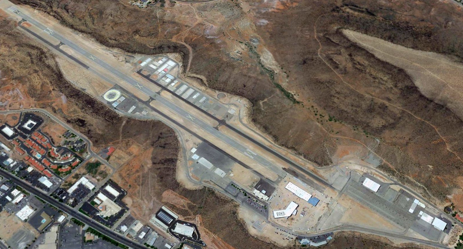
A 2017 aerial view looking southwest shows the original St. George Municipal Airport remains mostly intact, although a building was being constructed over the north end of the former runway.
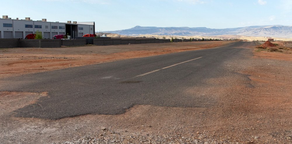
A 5/22/21 photo by Mike Legeros of the remains of the original St. George Municipal Airport runway.
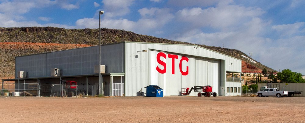
A 5/22/21 photo by Mike Legeros of a former St. George Municipal Airport hangar, reused by STG.
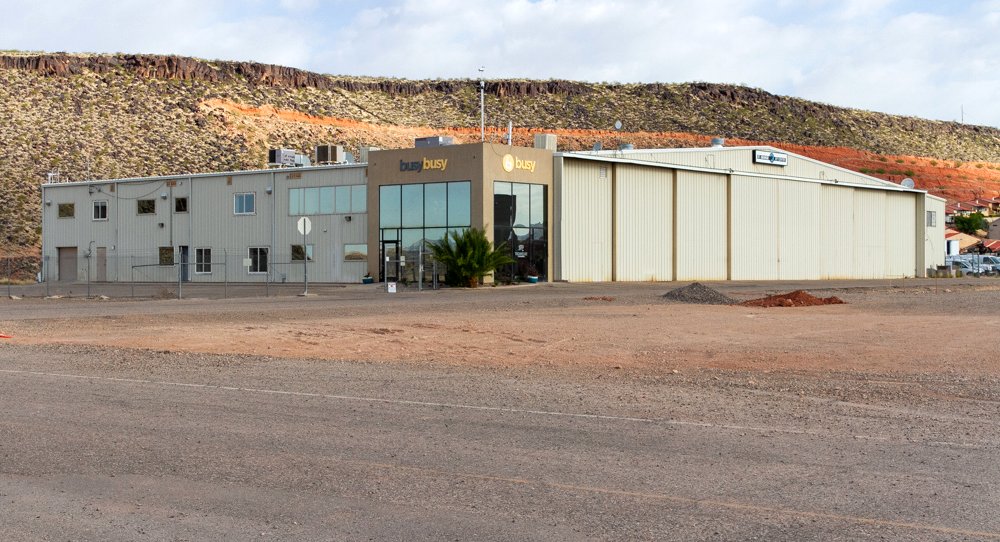
A 5/22/21 photo by Mike Legeros of a former St. George Municipal Airport hangar, reused by busybusy.
____________________________________________________
Or if you prefer to contact me directly concerning a contribution (for a mailing address to send a check),
please contact me at: paulandterryfreeman@gmail.com
If you enjoy this web site, please support it with a financial contribution.
____________________________________________________
This site covers airfields in all 50 states.