Abandoned & Little-Known Airfields:
Virginia: Northeastern Fairfax County
© 2002, © 2023 by Paul Freeman. Revised 6/20/23.
____________________________________________________
Please consider a financial contribution to support the continued growth & operation of this site.
Crossroads Airport / Washington-Virginia Airport (revised 6/20/23) - Springfield Airport (revised 2/9/20)
____________________________________________________
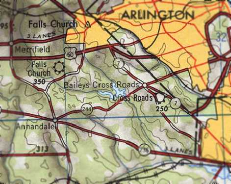
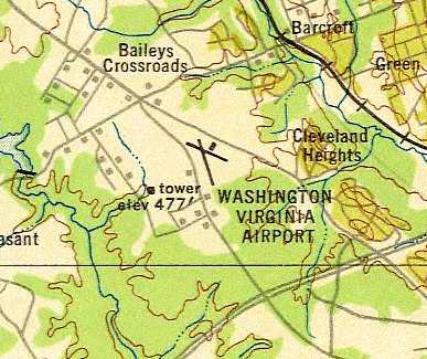
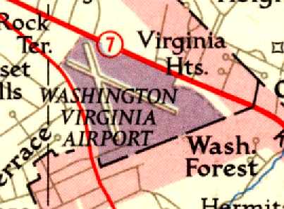
Crossroads Airport / Washington-Virginia Airport, Bailey's Crossroads, VA
38.845, -77.121 (Southwest of Washington, DC)
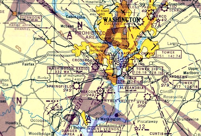
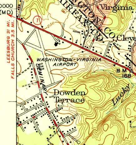
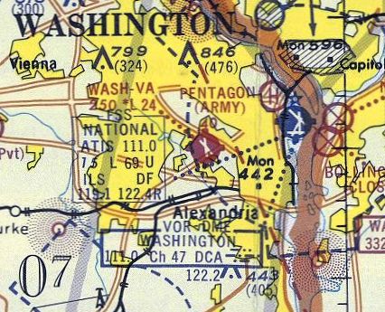
"Crossroads" Airport, as depicted on the December 1945 Washington Sectional Chart.
Everett Germain submitted an application in 1941 to locate an airport on Mary Cornelius’ land, under the name of Crossroads Airport.
Germain was doing business as Washington Air Charter Service, which at one point appears to have been a division of Mount Vernon Airways, Inc.,
which operated from the old Alexandria (Hybla Valley) Airport.
In 1942, a license was granted to Germain to build & operate Crossroads Airport.
It was planned to be 150 acres, with a NW/SE runway proposed to be 3,500' & a NE/SW runway of 2,500'.
However, wartime shortages of construction materials meant that the opening of the airport would have to wait until the end of WW2.
Crossroads Airport was not yet depicted on the June 1945 Washington Sectional Chart or the 1945 USGS topo map.
The earliest depiction which has been located of Crossroads Airport was on the December 1945 Washington Sectional Chart.
It depicted "Crossroads" Airport as a commercial airport.
According to Frank Perfetti, “The Benn brothers bought the airport in 1945.”
According to Richard Benn, “I am the grandson of John D. Benn Sr. the owner of Washington Virginia Airport.
I am sure that my grandfather did not pay more than $100,000 for the property.”
According to Wikipedia, John & Charles Benn applied to the Virginia State Corporation Commission, Division of Aeronautics, for a license to operate a commercial airport as "Bailey's Crossroads Airport".
Their application was heard & approved 5/16/46.
The 1946 USGS topo map depicted the field as “Cross Roads” Airport.
The airport was up & running by 1947, the flight school welcoming ex-GIs to the flying world.
The Benn brothers ran Bailey’s Crossroads for 2 decades. A north/south grass runway was laid out first.
This was used while the longer northeast/southwest runway, 12-30, was constructed & graveled. Later, the north/south runway was also graveled.
The 1947 Washington Sectional Chart depicted “Wash-VA” Airport as having a 2,800' unpaved runway.
By 1948 the flight school had 10 Piper J-3s, 2 Cessna 120s, a Cessna 140, a PT-19
and a UC-78 for twin-engine & instrument work.
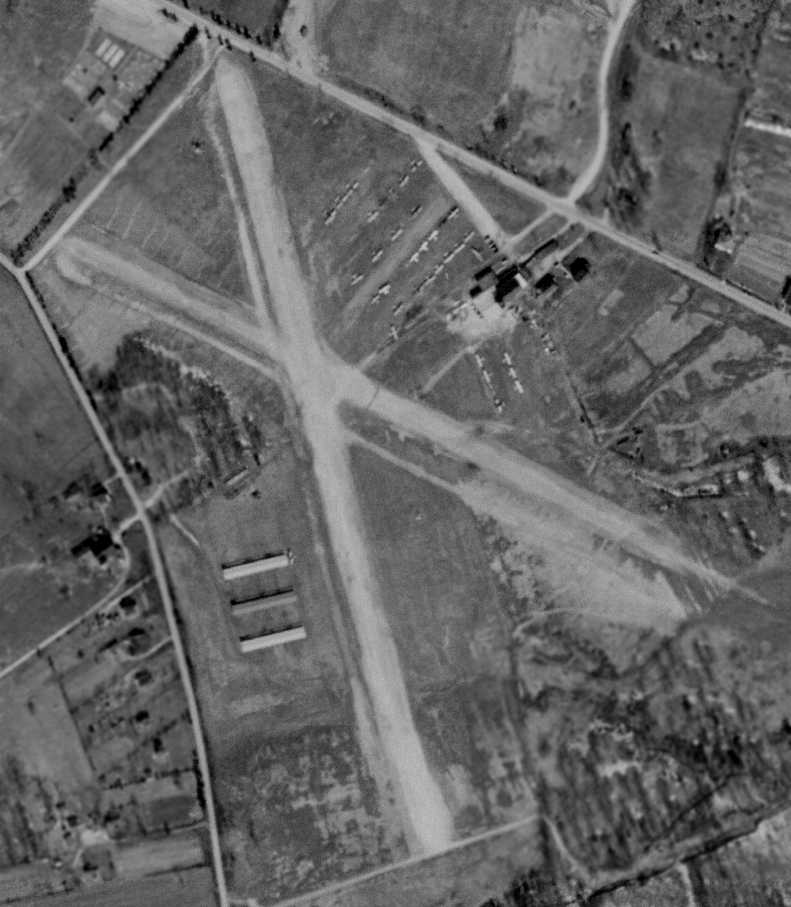
The earliest photo that has been located of Washington Virginia Airport was a 4/9/49 aerial view.
It depicted the field as having 2 unpaved runways, with hangars on the northeast & southwest sides of the field.
A total of 28 aircraft were visible parked on the northeast side.
A 1949 photo by Nick Proferes depicted 2 ERCO Ercoupes Washington Virginia Airport,
with the drive-in movie theater screen visible in the background.
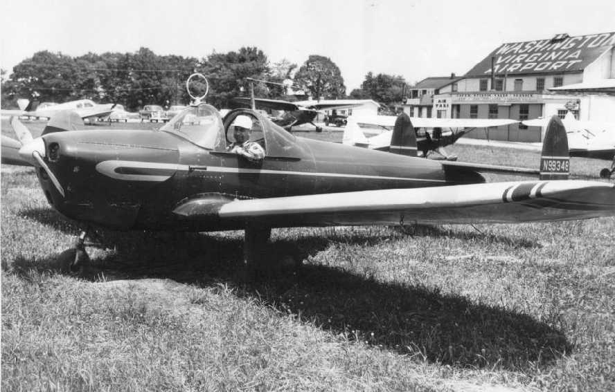
A circa 1949 photo of Nick Proferes in his newly-acquired ERCO Ercoupe at Washington-Virginia Airport.
Nick recalled of being at Washington Virginia Airport with his father, “I recall the place vividly,
having flown with him on many occasions since I was about 5 or 6 years old,
including the golf balls which used to somehow fly over the road from the driving range & make holes in his wings.”
The 1949 Washington Sectional Chart (courtesy of Mike Keefe)
described "Wash-VA" Airport as having a 2,800' unpaved runway.
The 1949 USAF Target Complex Chart depicted the Washington-VA Airport as having 2 runways
and a single hangar northeast of the runway intersection.
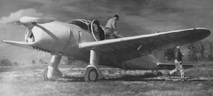
A circa 1940s-50s photo of a Duramold Aircraft Corporation F-46 at Washington-Virgnia Airport.
 l
l
The 1951 USGS topo map depicted Washington-Virginia Airport as having 2 paved runways, with several buildings on the northeast & southwest sides.
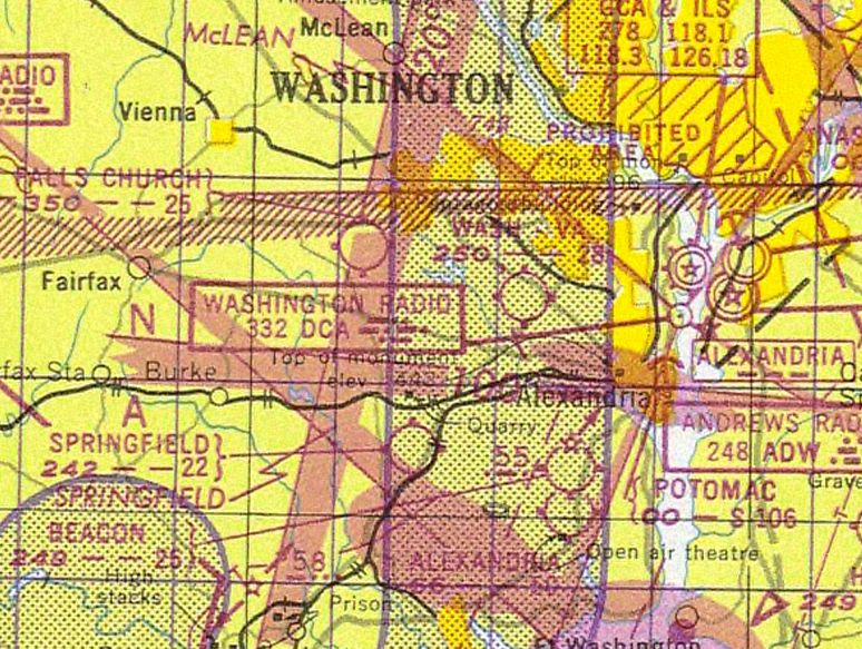
The January 1951 Washington Local Aeronautical Chart (courtesy of Tim Zukas)
depicted Washington-Virginia Airport as having a 2,800' unpaved runway.
A 1952 street map (courtesy of Kevin Walsh) depicted “Bailey's Crossroads Airport” as having 2 runways.
The 1955 Washington Local Aeronautical Chart (courtesy of Mike Keefe)
depicted Washington-Virginia Airport as having 2 runways, with the longest being a 2,800' unpaved strip.
At least one of the runways at Washington-Virginia was paved by 1957,
as the 1957 Washington Sectional Chart (courtesy of Mike Keefe) described the field as having 2 runways,
with the longest being a 2,800' hard-surface strip.
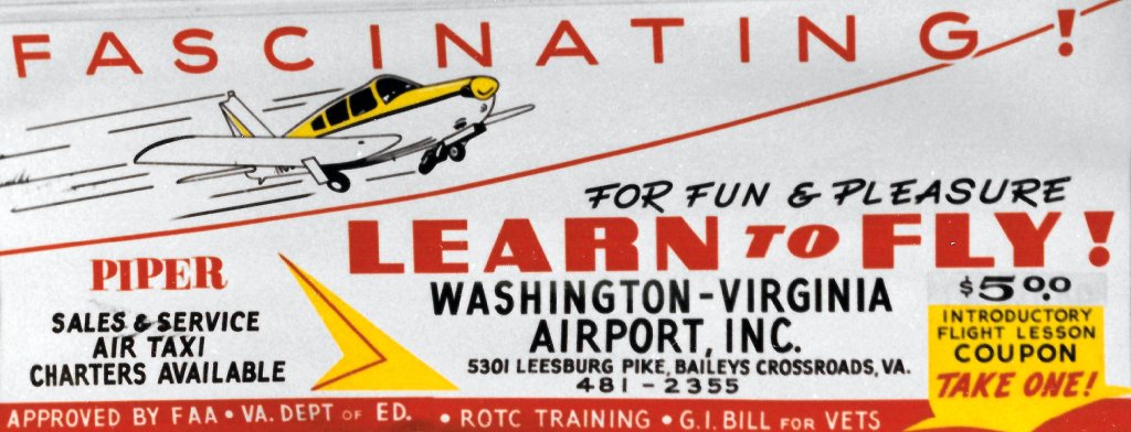
A 1958 Yellow Pages advertisement for Washington-Virginia Airport.
Power lines & encroaching buildings led to substandard approaches.
Nonetheless, its incredibly convenient location led to it becoming one of the most active airports in the DC area.
Eventually, hangar space for 70 aircraft was constructed & sales operations for Piper, Cessna & Beech were underway.
When nearby Beacon Field closed in 1960, a number of aircraft moved to W-VA.
By then well over 100 aircraft were based at Washington-Virginia Airport.
Due to the proximity of the Pentagon, manufacturers, including those of helicopters,
would demonstrate their wares at the airport to the Pentagon Brass.
This included a demonstration in 1951 or 1952 or the Piper PA-18 by Charles Lindbergh.
The first jet helicopter, the French Alouette, was also demonstrated there to officials
and the Goodyear blimp would come calling once a year or so.
But by the late 1950s, the suburbs of Washington were creeping past Bailey’s Crossroads & problems with the neighbors were increasing.
Washington-Virginia was listed among active airports on the 1960 Washington Sectional Aeronautical Chart,
with 2 paved runways (the largest was 2,800').
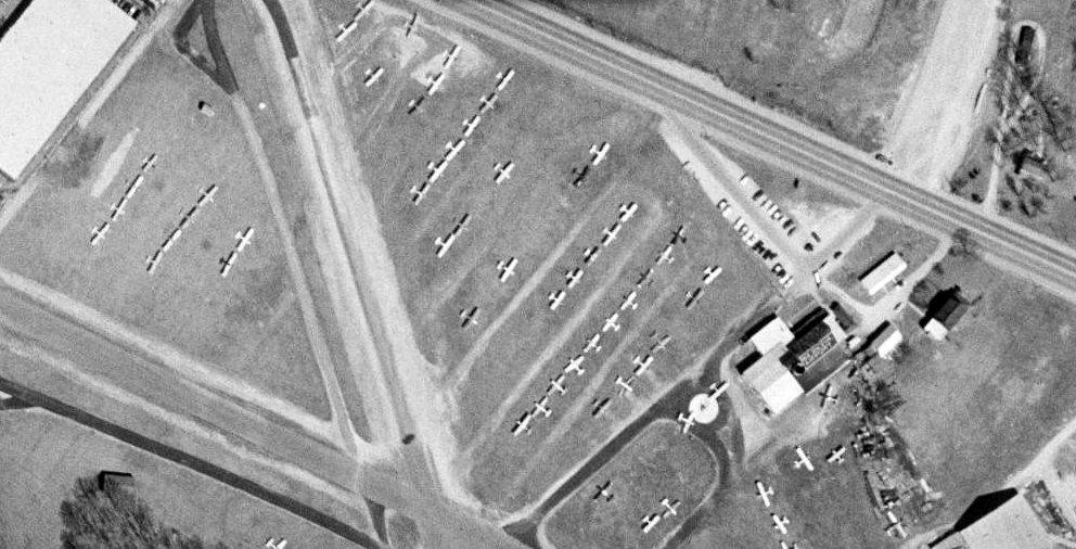
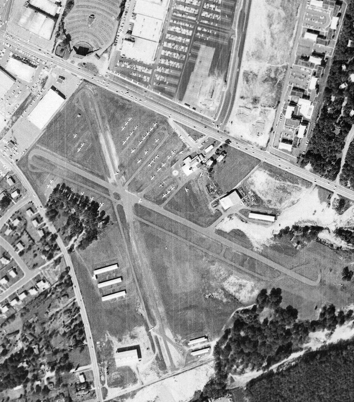
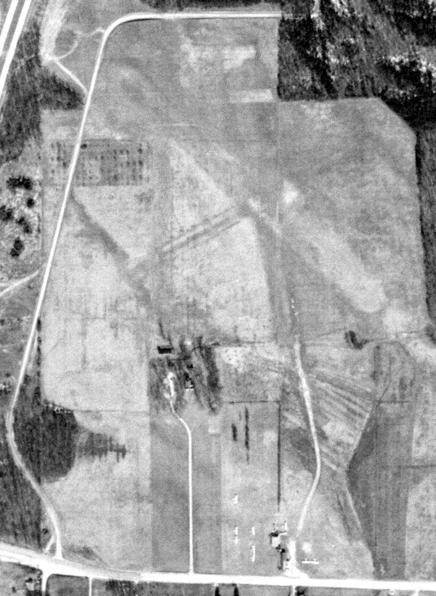
A 1960 aerial view (from the Fairfax County Historical Imagery Viewer) depicted a huge number of light aircraft parked on the north side of Washington-Virginia Airport.
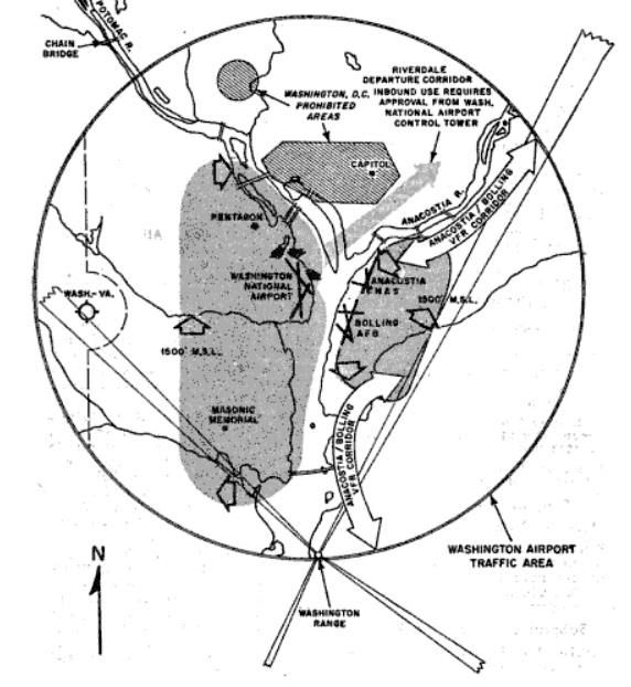
A 1961 diagram of the Washington Airport Traffic Area displayed a 1 mile cutout for Washington-Virginia Airport.
The 1962 AOPA Airport Directory described the field as having 2 asphalt runways (12/30: 2,800' long, and 17/35: 2,200' long).
A 1962 aerial view depicted Washington-Virginia Airport as having 2 paved runways.
Two new rows of T-hangars had been added on the southeast end of Runway 35 at some point between 1949-62,
along with 2 other hangars on the northeast side of Runway 30.
The airport was obviously well-used, as a total of over 52 light aircraft were visible on the field.
Charles T. Benn ran the fixed-base operation & student training activities.
The 1964 National Geographic Map of Suburban Washington (courtesy of David Brooks)
depicted the Washington Virginia Airport as having 2 runways.
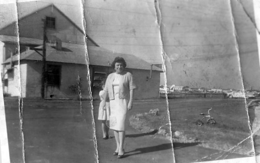
A February 1964 photo of Mary Simmons at Washington Virginia Airport (courtesy of Marcia Weikle).
Marcia Weikle recalled, “Mary was JD Benn, Sr's secretary & 'mistress'. Standing right behind her is my sister Sandy Weikle Bradley.
Behind them are the offices where the pilots checked in, and where there was also a barber shop for the pilots.”
Phil Lively recalled, “My mom worked as a medical secretary/office manager for a small group of doctors in a private practice in Arlington.
One of their patients was John Benn, who was the owner of the airfield at Baileys Crossroads.
Mr. Benn & his domestic partner, Mary Simmons, befriended my mother & us boys.
We were always welcome to visit his airfield & watch operations there. They were just the most wonderful people & very good to my brother & me.
By far the greatest thing they ever did for us is that in 1964 or 1965 Mr. Benn arranged for us to fly in the Goodyear blimp Columbia
on one of its visits to the region, during which it was moored at his airport.
I must have been 10 or 11 years old at the time. Can you imagine? What an experience, one I have never forgotten. Riding in the gondola was, in a phrase, super-cool.
There was almost no sensation of movement, very little of actual flight, a remarkable view of the region all the way into the city of Washington,
and because it pulled no G-forces, during turns one felt as though they were going to slide right out of their seat.
Not to mention that everyone on the ground was frozen in place gazing upwards at our airship.
I am certain that we must have been among a relatively few people who ever had such an opportunity.
I was provided with a little wallet-sized card inducting me into the Goodyear Blimp Club which I carried around for years, just in case anyone ever challenged my airship credentials!
Totally unforgettable, even now more than a half-century later.”
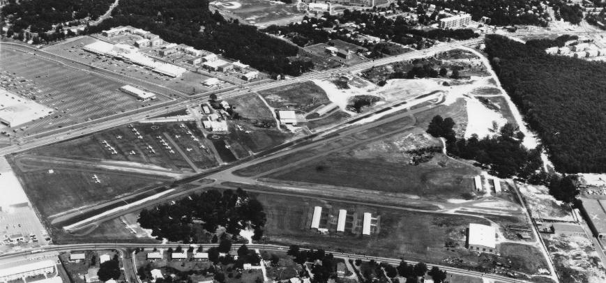
A 9/26/64 USGS aerial view depicted Washington-Virginia Airport as having 2 paved runways, and hangars on the west, south, and north sides.
At least 44 light aircraft were visible on the field. Note the drive-in movie theater directly across the street from Runway 17.
Marcia Weikle recalled, “My father, Lamar Weikle, worked for Mr. Benn in the 1960s.
When dad worked for Mr. Benn, we lived right on the airport.
I remember finding abandoned baby rabbits in holes on the runway because mama bunny set up housekeeping, got scared by the planes & ran off!
My mom tried to save many a bunny!”
Marcia continued, “In the 1960s my dad was building a hangar, and was in the field by himself.
A very strong wind came about & blew him off the roof of the hangar he was working on.
Three two-by-fours landed on top of him that day. He dragged himself to the truck he was using & collapsed unconscious across the steering wheel.
Other workers (friends) heard the beeping, knew he was working on the hangar & knew something was drastically wrong.
I was in the 2nd or 3rd grade that year at Glen Forrest Elementary.
When I got home from school with my older sister, for the first time in our lives, we had a babysitter. My dad was fighting for his life.
It took him 6 months to be able to fully function again. When he came home, he was in a wheelchair.
The accident crushed every bone in both of his wrists, smashed a kneecap to pieces, and just generally incapacitated my dad for a long time.
My mom had five children to take care of, all under the age of 9, the littlest just a couple of months old.
Now she had a husband needing care as well. Mr. Benn & his love (Mary ?) took care of us the best they could.
Mr. Benn thought so much of my dad as he was a WWII vet & a very hard worker. My dad was much respected by the pilots that came in.”
A circa 1960s trolley car advertisement for Washington-Virginia Airport (photographed by Tom Buckley in the mid-2010s at the National Capital Trolley Museum).
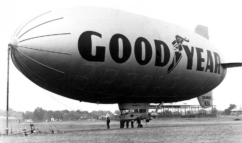
A circa 1964-65 photo by Mike Keefe of the Goodyear Blimp Columbia at the Washington-VA Airport.
According to Mike Keefe, the Goodyear Blimp visited the Washington-Virginia Airport
and was featured in several photographs in the Evening Star newspaper.
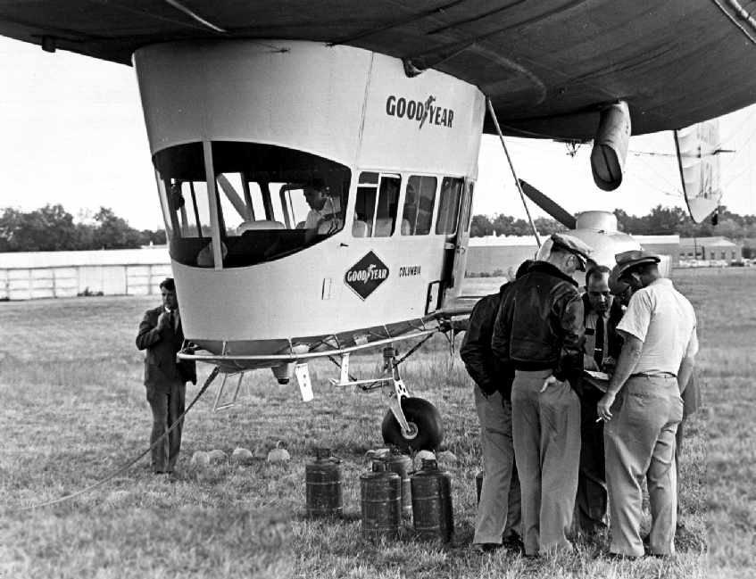
A circa 1964-65 close-up by Mike Keefe of the Goodyear Blimp Columbia at the Washington-VA Airport.
What appear to be hangars are in the background at left.
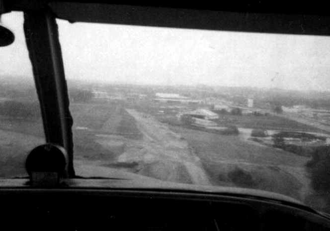
A 1965 photo taken by Robert Morris with his Polaroid Swinger camera approaching Washington Virginia Airport.
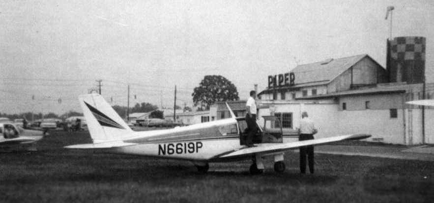
A 1965 photo taken by Robert Morris of his Piper Comanche at Washington Virginia Airport.
In 1966, the state provided $22,000 to relocate & improve Washington-Virginia Airport's east/west runway
provided that the north/south runway (which barely cleared Route 7) was closed.
A circa mid-1960s aerial view looking east at Washington-Virginia Airport. Note the drive-in movie screen directly across the street from the threshold of Runway 17.
Gordon Gallison recalled, “Washington-Virginia / Bailey's Crossroads Airport: You cannot emphasize enough about the outdoor movie screen on the approach to the airport.
On my first landing in a Mooney Ranger there, one of the airport's instructors told my Dad that I wasn't going to make it.
I proved him wrong, but not by much. I liked the airport as it was only 3 miles from where my folks lived.”
The March 1966 Washington Local Aeronautical Chart depicted Washington-Virginia Airport as having 2 paved runways, with the longest being 2,300'.
Note it also depicted the drive-in movie theater directly across the street.
Richard Benn recalled, “During the 1960s many aircraft were brought to the airport
for demonstration to the defense department as well as members of the House & Senate.
They include the North American OV-10 Bronco & De Havilland Caribou
as well as the McDonnell Douglas STOL transport operated by Eastern Airlines
[the McDonnell Douglas 188 – which might have been the largest aircraft to operate from Washington-VA Airport].
The airport's close proximity to the Pentagon & downtown DC made it very attractive for this purpose.”
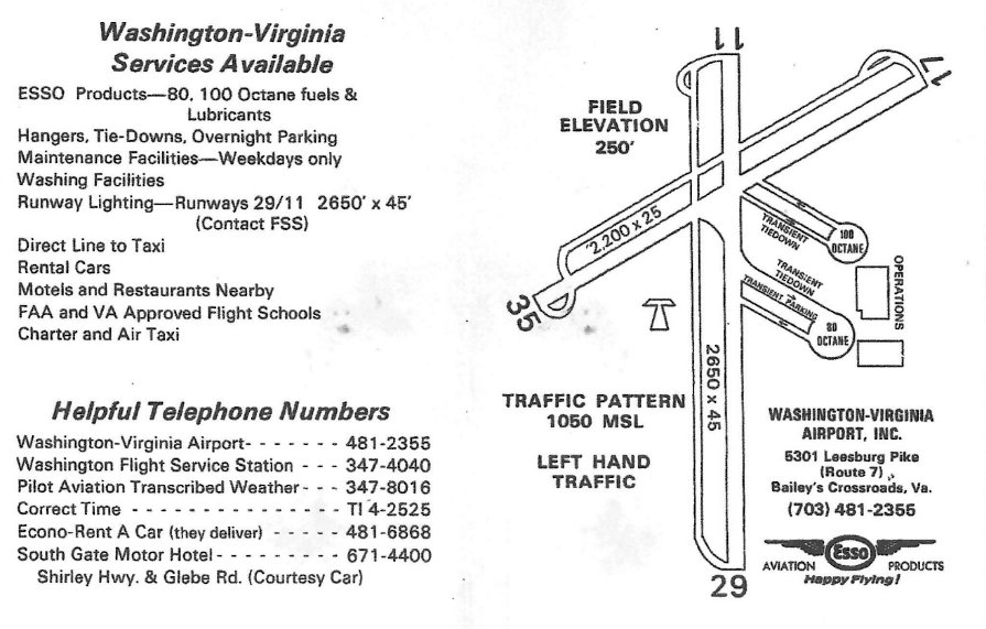
A circa 1960s airport directory (courtesy of Bob Bruch) depicted Washington-Virginia Airport as having a 2,650' Runway 11/29 & a 2,200' Runway 17/35.
Frank Perfetti recalled, “Washington/Virginia Airport was where I learned to fly
starting in November 1966 at the young age of 15 years old.
I remember that 2 initial solos were required: one on the long runway & one over the drive-in theater screen,
that runway was so narrow that landing in the grass on the side was quite acceptable.
Charlie Ben was landing a Aztec over the screen one day & hit it with his main landing gear leaving 2 tire marks on top of it.
On the bottling plant at the other end there were big X's painted on it
because someone had landed their J3 Cub on the roof one day & stopped it before reaching the other end.
One time someone lost their engine on takeoff & crashed in the Toys-R-Us parking lot.
Also 9 AT-6s modified to look like Japanese Zeros landed there one day
on their way to the filming of the movie 'Tora-Tora-Tora'.
One of them lost control crashing into a couple parked airplanes & had to have its wing replaced.”
Phil Lively recalled, “As for Mr. Benn, the airport was his life. He was a large somewhat gruff character, except when around us youngsters.
One winter February day he went out in one of those old-school road graders to clear snow from the main runway.
Shortly thereafter some of crew noticed that the grader had been parked & idling at the head of the strip for some time.
When they checked they found Mr. Benn deceased at the wheel from what I recall being a major heart attack.
So it could be said that in an ironic sense it was his death as well.”
According to Richard Benn (grandson of airport owner John D. Benn Sr.), “John D. Benn Sr. passed away 12/1/67.
My father John D. Benn Jr. took over operations & also started to teach me (officially as this is when my log book starts) to fly at the young age of 10.”
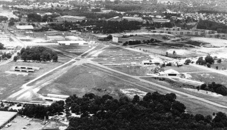
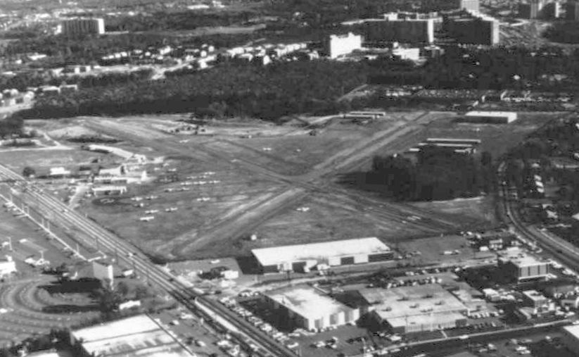
A circa 1960s aerial view looking northwest at Washington-Virginia Airport.
Note the drive-in movie screen across Route 7, directly in the path of Runway 17.
An undated aerial view looking northeast at Washington-Virginia Airport.
Note the area across Route 7 formerly occupied by the drive-in movie theatre had already been redeveloped into another shopping center.
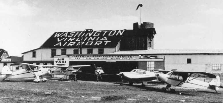
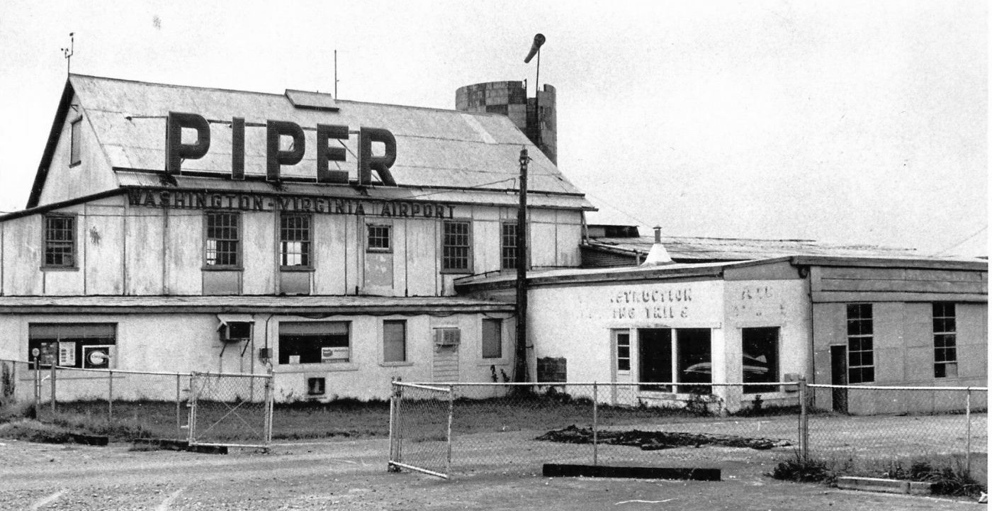
An undated view of the main hangar of Washington-Virginia Airport.
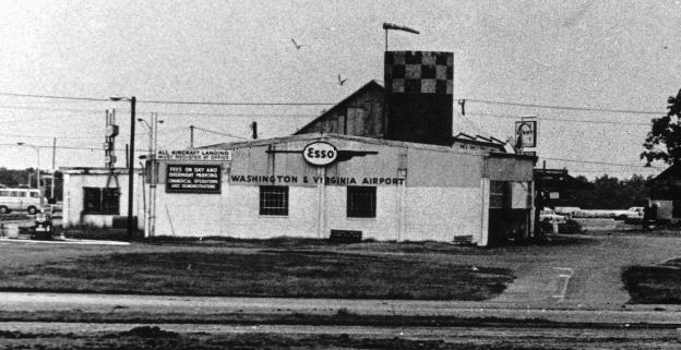
A 1968 photo of the Washington-Virginia Airport office.
Note the sign for the Giant supermarket (just above & to the right of the office) which had already been built across Route 7,
foreshadowing the increasing development which would eventually doom the little airport.
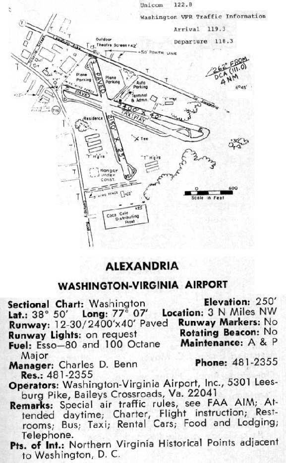
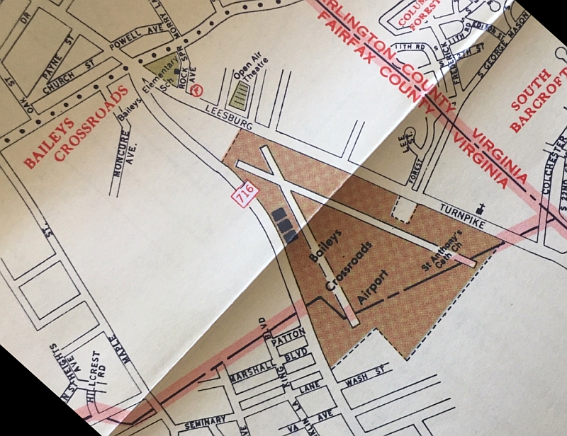
The 1968 Virginia Airport Directory (courtesy of Don Thompson) depicted the Washington-Virginia Airport
as having a 2,400' Runway 11/29 & a 2,150' Runway 17/35.
It also said that the airport was subject to "special air traffic rules, see FAA AIM".
Washington-Virginia was always an amusing airport to fly in & out of,
surrounded by various power lines, apartment houses & commercial buildings.
There was a Coca Cola distribution center building about 500' from the threshold of runway 35.
A 42' high drive-in movie screen was a bit to the side & just off the threshold of runway 17.
At night you could catch a minute of 2 of Humphrey Bogart & Ingrid Bergman in Casablanca
on each downwind & while turning base for runway 11.
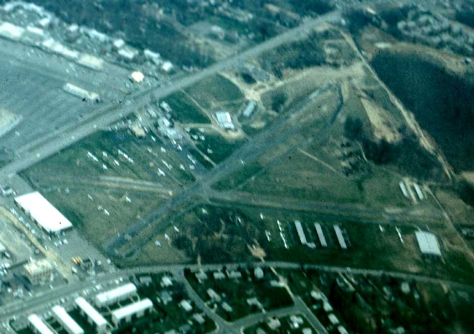
A 1969 aerial view looking northeast by Frank Perfetti depicted Washington-Virginia Airport as being a very popular airport,
with several dozen light aircraft parked on the field.
Frank observed, “On the left side next to the runway that goes over the drive-in theater screen (Runway 17/35) [is] a brown streak.
Because of the extreme narrowness of the runway a lot of airplanes would land on the grass on the side of the runway.
I did a number of times myself, and it was considered normal.
That is the point where most airplanes landed & then rolled onto the runway.”
After airport owner J.D. Benn Sr. died, an era began to end.
The continuing pressures from neighbors & the recognition by the family that the land value - and the taxes - had grown so huge,
that it could be no longer operated as a privately-owned airport.
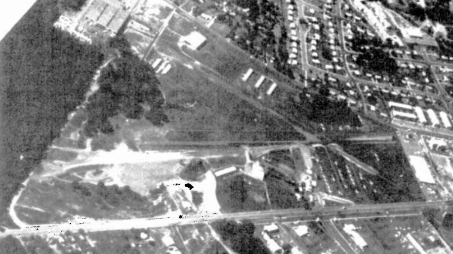
The last photo which has been located showing Washington-Virginia Airport still open was a 1970 aerial view looking south (from the Fairfax County Public Library, courtesy of Derek Rowan).
It depicted several dozen light aircraft parked on the field.
Frank Perfetti recalled, “Just before the closing of the airport someone was doing a pre-buy purchase of one of the flight school's Cherokee 140s,
he missed the drive-in theater screen but hit the high tension power lines,
bringing them down & electrifying the whole line of fence welding a gate shut
and passing into the airport's power line feed, popped the runway lights & electrified the water fountain inside the building.”
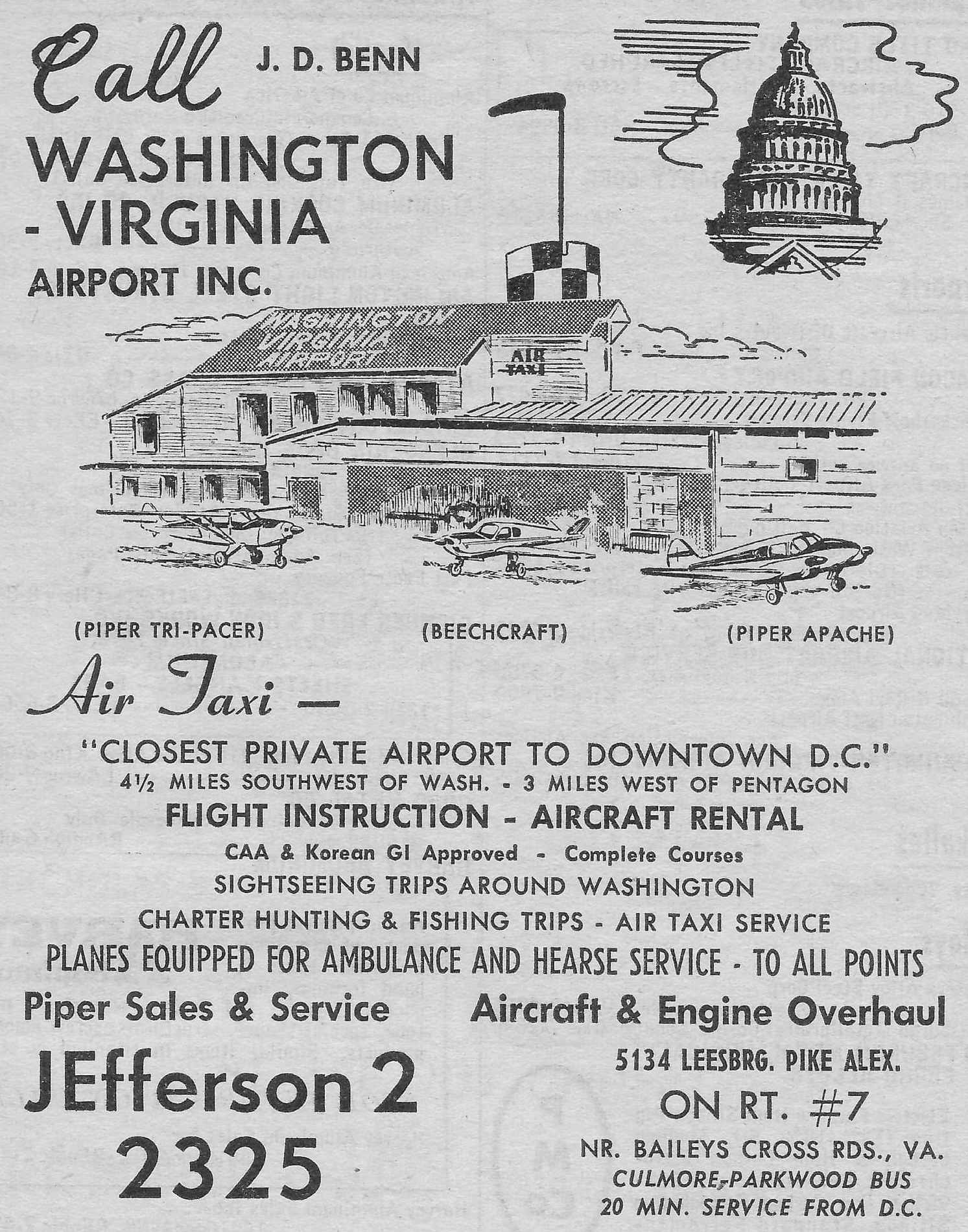
The 1970 AOPA Airport Directory (courtesy of Mark Sublette)
described the Washington-Virginia Airport as having 2 macadam runways: 2,650' Runway 11/29 & 2,200' Runway 17/35.
The airport was described as offering fuel, repairs, hangars, tie-downs, and charter,
and the operator was listed as Washington Virginia Flight Service (also a Piper dealer).
According to the book "Virginia Airports" by Vera Rollo & Norman Crabill (published by the VAHS),
the Washington-Virginia Airport closed on 10/18/70.
An undated photo, presumably showing the Washington-Virginia Airport office after the airport's closure.
Even though it had closed the year before, Washington-VA Airport was still depicted on the 1971 Washington Sectional Chart (courtesy of Ed Francis).
It depicted Wash-VA as having 2 paved runways, with the longest being 2,400'.
Washington-Virginia Airport was no longer depicted on the 1971 USGS topo map
or the September 1972 Washington Sectional Chart.
A 1972 aerial view (from the Fairfax County Historical Imagery Viewer) showed the Skyline Towers under construction on the site,
removing the vestige of Washington-Virginia Airport.
According to Richard Benn, “The Benn Family went into partnership with the Charles E. Smith Company to develop Skyline Center.”
Mary Cornelius’ original acreage was redeveloped as the Skyline high-rise office buildings, apartment towers, and shopping complex.
Frank Perfetti recalled, “In its 25 years of operation there was never a fatal crash there
but when they turned it into apartments [14] workmen were killed
when concrete shoring was removed too soon & the building collapsed on them”, on 3/2/73.
A 1976 aerial view (from the Fairfax County Historical Imagery Viewer) showed the Skyline towers having been built on the site,
with no trace remaining of Washington-Virginia Airport.
The Skyline complex was completed in 1977 on the site of Washington-Virginia Airport.
A 1979 aerial view showed that the new buildings had covered the site of Washington-Virginia Airport.
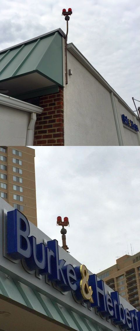
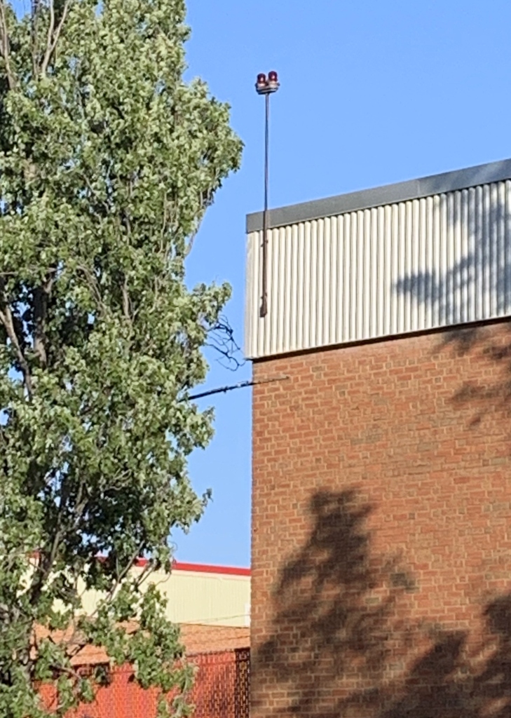
Darren Fox observed in 2004 "some existing evidence of the airfield.
There is today, a Burke & Herbert Bank on Seminary Road right next to a Shell station
that is at the corner of Seminary & Carling Springs Roads.
It turns out that there are 2 sets of 2 marker light on the bank building!
The lamps are long since dead, but the red glass beacons are still there today.
I personally remember these beacons working when the airfield was in operation
as they marked this little building that sat at just outside the airfield property at the end of Runway 11/29!"
![]()
A 2004 photo by Darren Fox of the Burke & Herbert Bank building at Seminary Road & Gorham Street,
which still has 2 sets of former Washington-Virginia Airport marker lights on the roof.
The 2 towers of the Skyline apartment complex (which were built on the site of the airport) are in the background.
![]()
Darren Fox indicated the location of the building which still has the marker lights on the 1968 Washington-Virginia Airport layout & a vintage photo of the airport,
making it obvious why this building needed obstacle lights - it sat directly off the end of the runway!
Darren Fox recalled, "I remembered it seemed that those Cessnas & Pipers would miss those beacons by only a few feet!
If memory serves me right, I think that this Burke & Herbert bank was a BP gas station in the last days of the airport.
I spoke to my father today, and seem to remember the BP station too."
Barara Helm reported in 2009, “I recall that at one time there was a room or two dedicated to the former airport in one of the Skyline towers on the bottom floor
and a small cafe named for the old airport or some part of it.”
Two 3/12/16 photos by Tom Reich of some of the last remnants of Washington-Virginia Airport:
the front & rear set of airfield lights which remain on the Burke & Herbert Bank building.
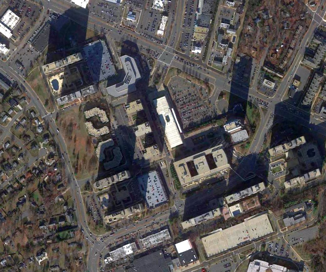
A 2016 aerial view shows the Skyline towers covering the site of Washington-Virginia Airport.
An October 2019 photo by Lawrence Hale of some of the last remnants of Washington-Virginia Airport:
the red airport obstruction lights which remain on the top corner of the Coca-Cola plant on Dawes Lane.
Lawrence recalledm “I was guessing it might still also have airport lights since the plant was a marked hazard on the old airfield diagrams.”
See also: The VA Aeronautical Historical Society Newsletter.
____________________________________________________
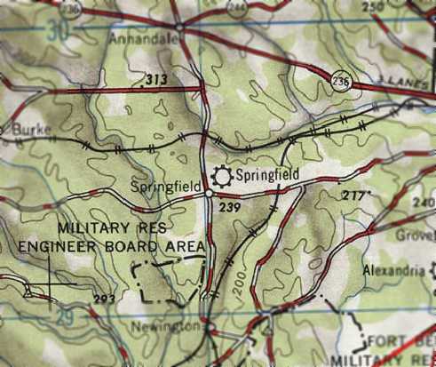
Springfield Airport, Springfield, VA
38.782, -77.175 (Southwest of Washington, DC)
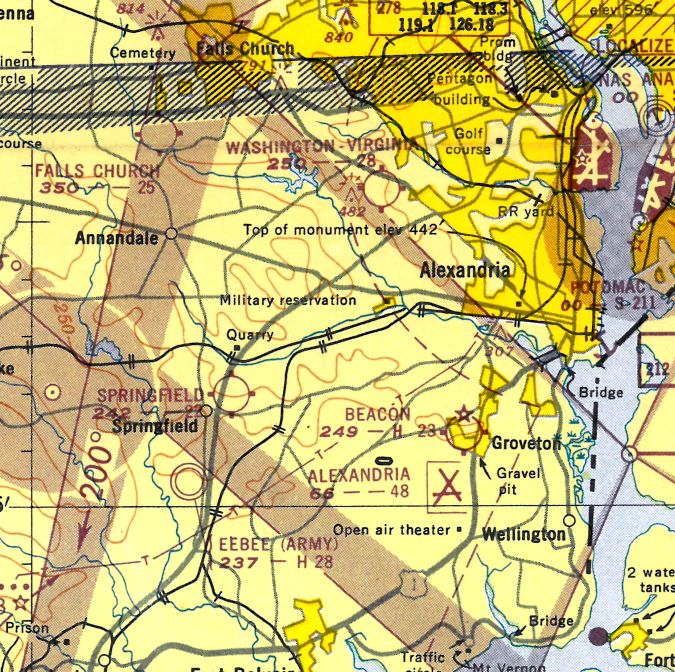
Springfield Airport, as depicted on the December 1945 Washington Sectional Chart.
Today, millions of drivers pass through the infamous "mixing bowl" - the intersection of the Washington Beltway & Interstate 95,
which is renowned as a traffic bottleneck among Washington commuters.
However, how many of those drivers know that this spot was once the location of the Springfield Airport?
Springfield Airport was evidently established at some point between 1944-45,
as it was not depicted on the 1944 Washington Sectional Chart or the 1945 USGS topo map.
According to the book "Virginia Airports" by Vera Rollo & Norman Crabill (published by the VAHS),
Springfield Airport was opened "after WW2" by Carl Allen.
"The airport had a north/south 3,000' sod runway & offered fuel & maintenance to the public."
The earliest depiction which has been located of Springfield Airport was on the December 1945 Washington Sectional Chart.
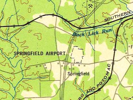
It depicted Springfield as a commercial airport, adjacent to the south side of the Southern railroad tracks.
Springfield Airport, as depicted on the 1946 USGS topo map.
In 1947, Charlie Kulp (who would later go on to fame as the Bealton Flying Circus' “Flying Farmer”)
worked as an Airframe & Powerplant mechanic at Springfield Airport
(according to an article by Linda Burdette in the 1/06 issue of the VAHS Virginia Eagles newsletter).
The September 1948 USAAF Pilot's Handbook (courtesy of Chris Kennedy)
depicted Springfield Airport, but did not give any other details about the field.
The 1948 Washington Sectional Chart (courtesy of Chris Kennedy) & 1949 Washington Sectional Chart (courtesy of Mike Keefe)
described Springfield Airport as having a 2,200' unpaved runway.
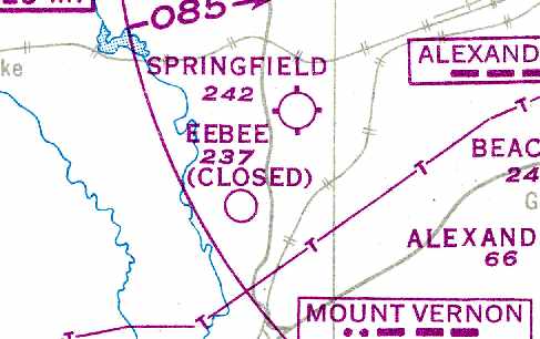
The irregular outline of the Springfield Airport property was depicted on the 1949 USAF Target Complex Chart, but no runways were depicted.
The planned alignment of Interstate 95 was also depicted running adjacent to the west side of the airport property.
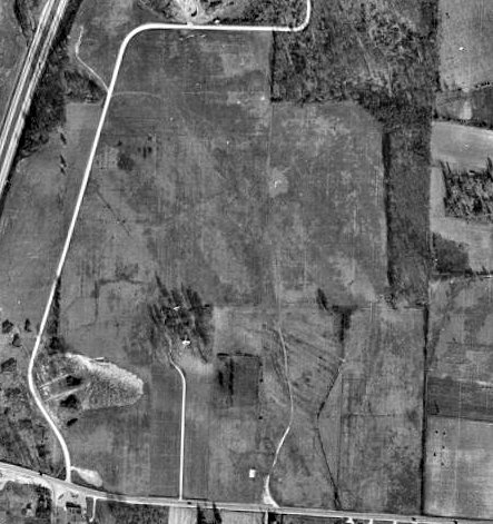
The only photo which has been located showing Springfield Airport in operation was a 3/4/49 USGS aerial view.
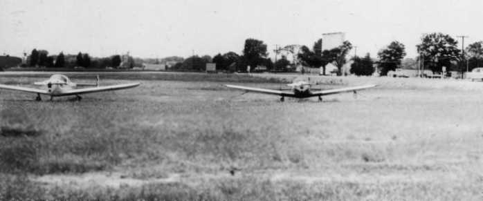
It depicted Springfield Airport as having 2 grass runways in an “X” shape, with a hangar & 9 single-engine light aircraft on the south side.
Charlie Kulp left his job as an A&P Powerplant mechanic at Springfield Airport in 1950
(according to an article by Linda Burdette in the 1/06 issue of the VAHS Virginia Eagles newsletter).
At some point afterward, the owner of the airport & his wife were killed in an airplane crash, and the airport closed soon afterward.
The last aeronautical chart depiction which has been located of Springfield Airport was on the January 1951 Washington Local Aeronautical Chart (courtesy of Tim Zukas).
It depicted Springfield Airport as having a 2,200' unpaved runway.
Springfield Airport was evidently closed by 1951,
as the remarks in the Aerodromes table on the 1951 Washington Sectional Chart (courtesy of Mike Keefe) said "Closed indefinitely."
It was described as having 3 runways, with the longest being a 2,770' unpaved strip.
The 1951 USGS topo map showed the newly-constructed Interstate 95 having been built along the west side of the site of Springfield Airport.
A 1953 aerial view (from the Fairfax County Historical Imagery Viewer) depicted Springfield Airport after its closure.
The property remained clear, but the runways were only barely recognizable.
According to the book "Virginia Airports", "As in so many other cases, developers purchased the land & built a large residential subdivision, Springfield Estates."
Springfield was a short-lived airport, apparently lasting no more than 7 years.
It was obviously doomed by its location, directly adjacent to the paths of both the Washington Beltway & Interstate 95, which were constructed in the 1950s.
By the time of the February 1960 Washington Local Aeronautical Chart, Springfield Airport was no longer depicted.
A 1960 aerial photo showed houses covering the site, with not a trace remaining of Springfield Airport.
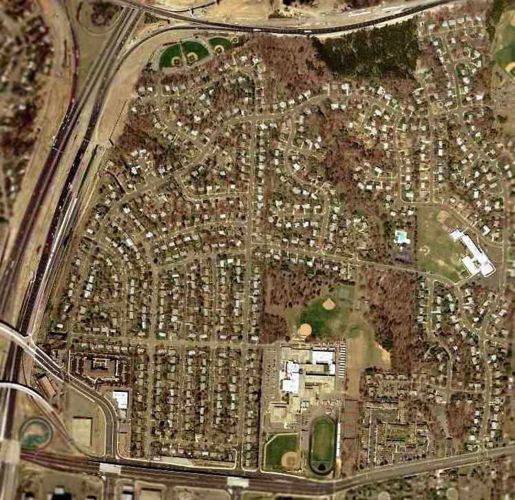
As seen in the 2002 USGS aerial photo, the site of Springfield Airport is now a densely developed residential neighborhood,
adjacent to the infamous "mixing bowl" - the intersection of the Washington Beltway & Interstate 95.
Not a trace appears to remain of the former Springfield Airport.
____________________________________________________
Or if you prefer to contact me directly concerning a contribution (for a mailing address to send a check),
please contact me at: paulandterryfreeman@gmail.com
If you enjoy this web site, please support it with a financial contribution.
____________________________________________________
This site covers airfields in all 50 states.