Abandoned & Little-Known Airfields:
Virginia: Western Fairfax County
© 2002, © 2025 by Paul Freeman. Revised 11/11/25.
____________________________________________________
Please consider a financial contribution to support the continued growth & operation of this site.
Centreville Airport (revised 12/14/18) - Falls Church Airpark (revised 11/11/25)
Herndon Nike Missile Battery W-83 Launch Site (revised 12/14/18) - Herndon Nike Missile Battery W-83 Integrated Fire Control Site (revised 6/16/23)
____________________________________________________
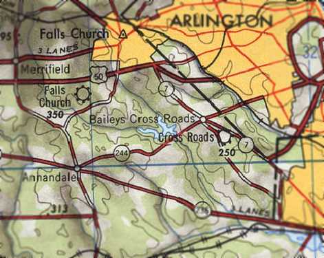
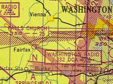
Falls Church Airpark, Falls Church, VA
38.865, -77.2 (West of Washington, DC)
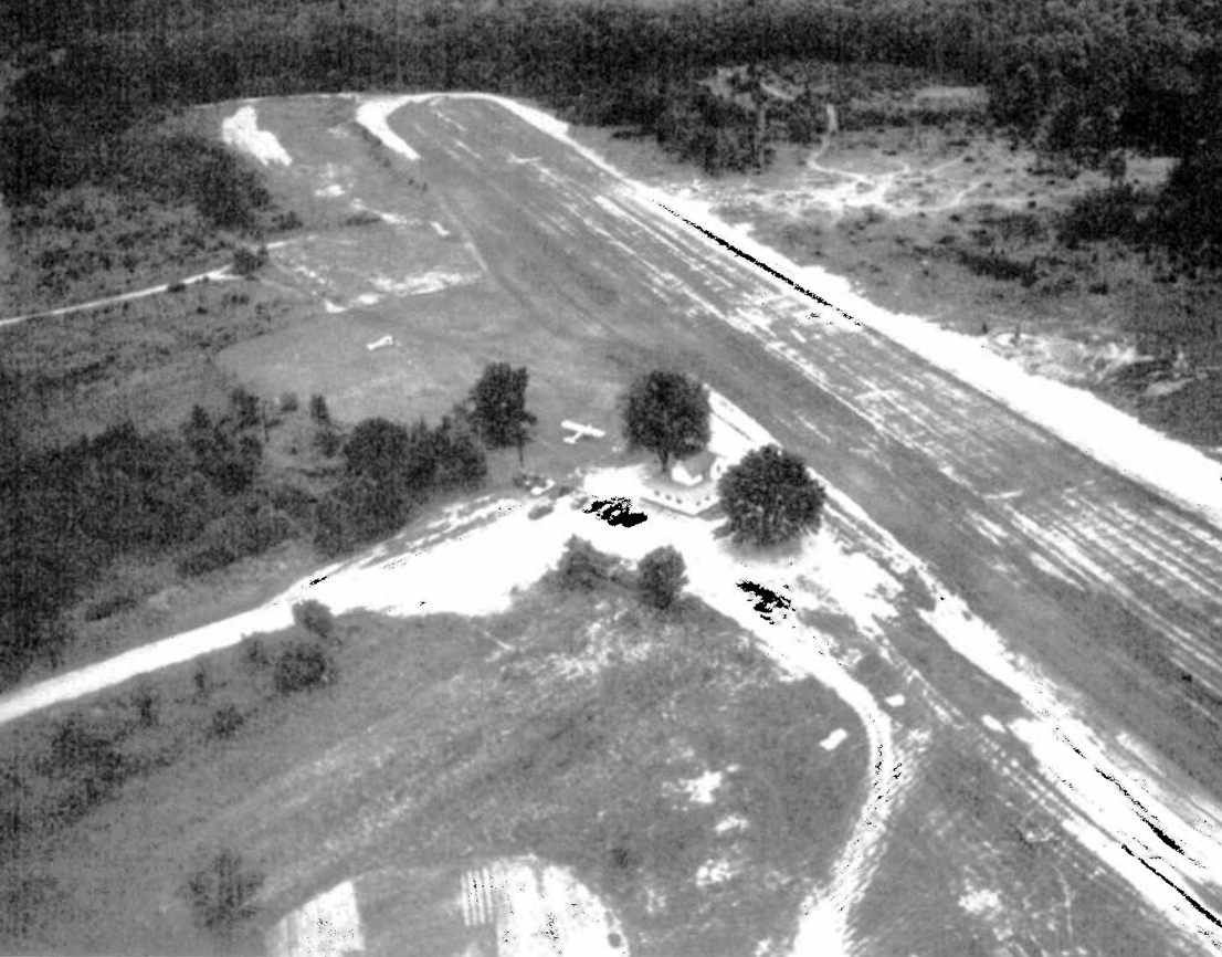
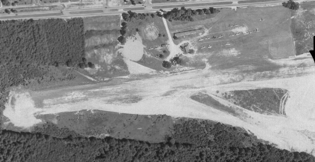
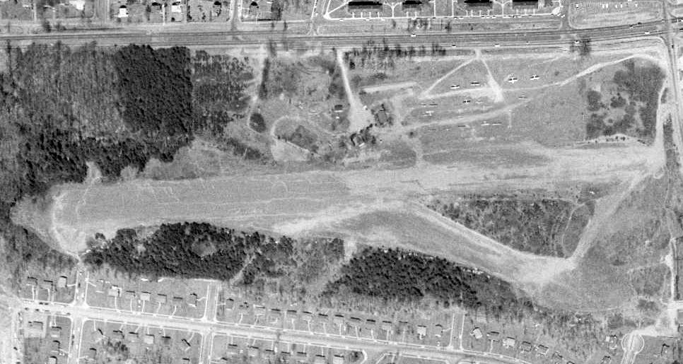
A 1946 aerial view looking southeast at Falls Church Airpark (from the Falls Church Public Library, courtesy of Derek Rowan).
Falls Church Airpark was not yet depicted on a 1937 aerial photo (from the Fairfax County Historical Imagery Viewer).
According to the book "Virginia Airports" by Vera Rollo & Norman Crabill (published by the VAHS),
"The Falls Church Airpark Inc. airport license was granted on 7/25/45."
Falls Church Airpark was not yet depicted on the April 1946 Washington Sectional Chart.
According to Falls Church resident Mark Sublette, “The Falls Church Airpark... opened in 1946 as 3,000' grass strip
and I don't believe it was ever paved.”
The earliest depiction of the Falls Church Airport which has been located was a 1946 aerial view looking southeast (from the Falls Church Public Library, courtesy of Derek Rowan).
It depicted Falls Church Airport as having an unpaved east/west runway, with 1 light single-engine taildragger nex to a house.
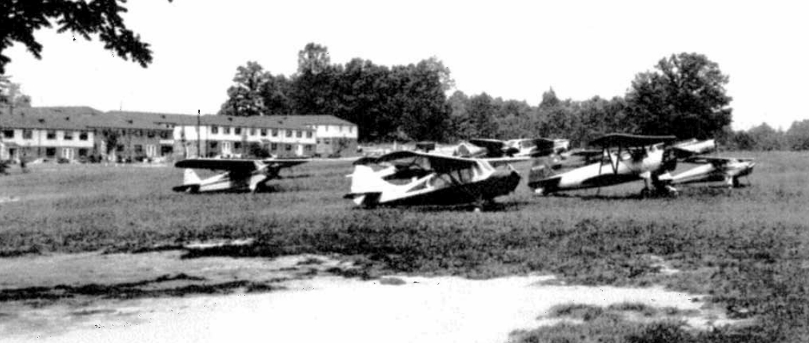
A 7/7/46 photo of 9 single-engine taildragger general aviation aircraft at Falls Church Airpark (from the Falls Church Public Library, courtesy of Derek Rowan),
including a surplus Vultee BT-13 military trainer.
Note the uncomfortable proximity of the Jefferson Village apartments in the background – a sign of the pressures which would eventually doom the little airport.
The earliest aeronautical chart depiction of the Falls Church Airport which has been located was on the October 1946 Washington Sectional Chart.
It depicted Falls Church Airport as a commercial/municipal airport.
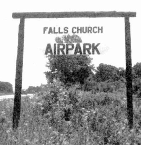
An undated photo of the sign for Falls Church Airpark (from the Falls Church Public Library, courtesy of Derek Rowan).
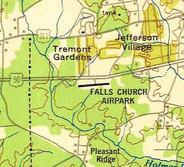
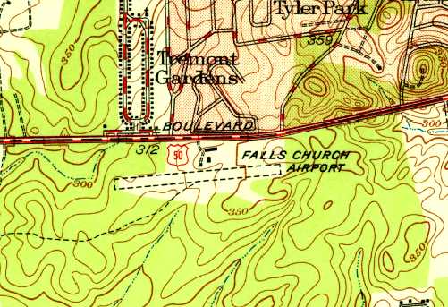
Falls Church Airpark, as depicted on the 1946 USGS topo map.
The 1947 Washington Sectional Chart depicted Falls Church Airpark as having a 2,500' unpaved runway.
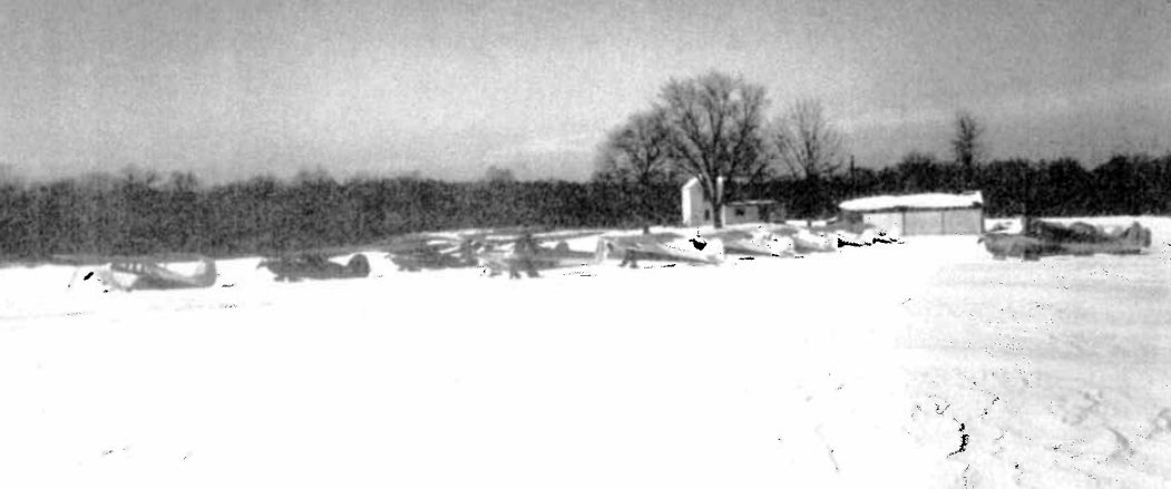
A winter 1947 photo of a dozen light single-engine general aviation aircraft at a snow-covered Falls Church Airpark (from the Falls Church Public Library, courtesy of Derek Rowan).
The Falls Church Airpark "tract was located on 60 acres of the Eisenhower Farm" (according to the book "Virginia Airports").
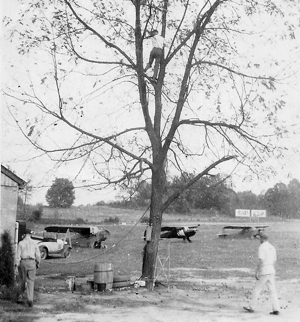
A circa late 1940s photo by Frank Beck (courtesy of Tony Beck) looking northeast from near the south end of the Falls Church Airpark hangar.
Tony Beck observed, “It has to be from the late 1940s, as there is nothing built on the far side of Arlington Boulevard.
The fellow in the tree is Joe Anderson & the man in white on the lower right is Ray.”
The 1949 USAF Target Complex Chart depicted Falls Church Airpark as having a single east/west runway.
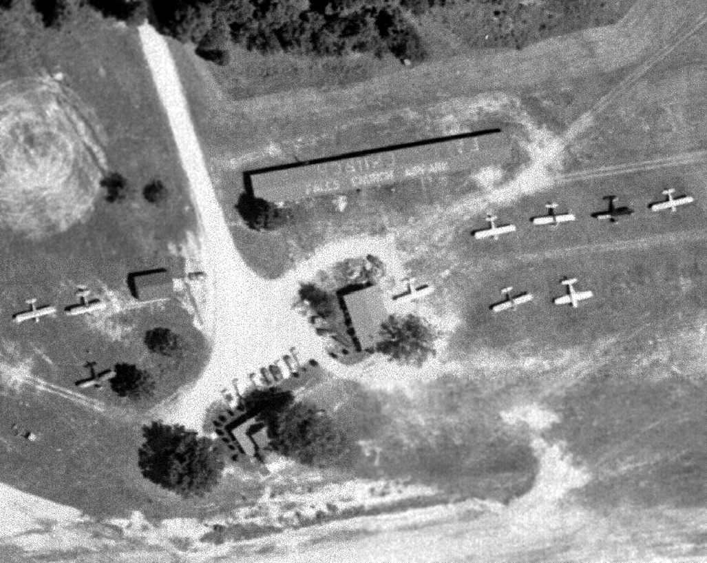
A 1949 aerial photo depicted Falls Church Airpark as having a single east/west grass runway, with signs of a crosswind runway.
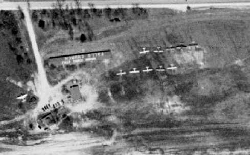
A closeup from the 1949 aerial photo, showing the hangar on the north side of the field with “Falls Church Airpark” painted on its roof,
and a total of 11 light aircraft parked on the field.
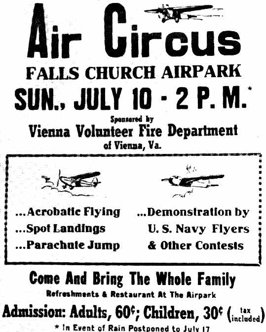
An advertisement for the 7/10/49 Air Circus held at Falls Church Airpark (from the Styles Public Library, courtesy of Charlie Davis).
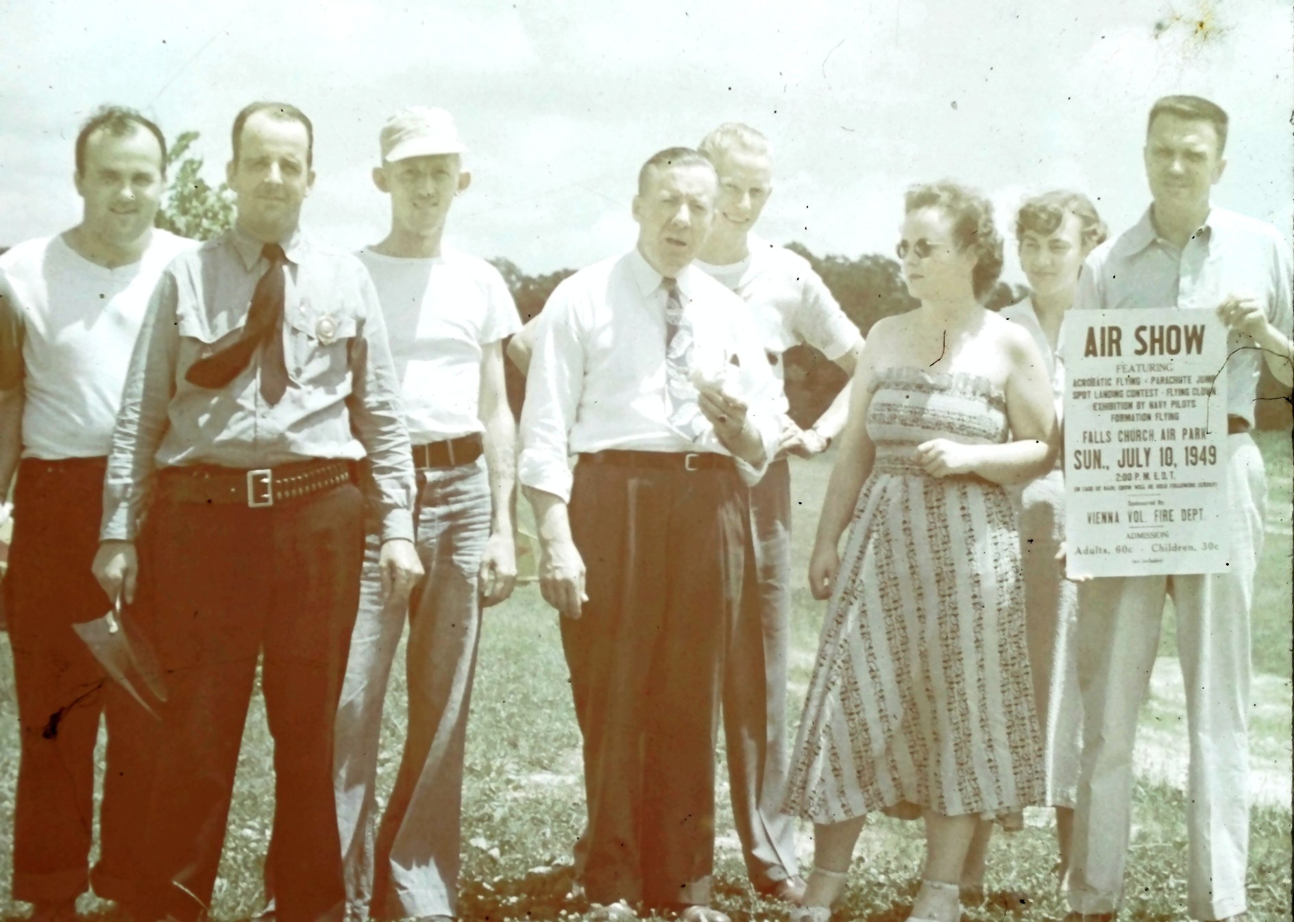
A group holding an advertisement for the 7/10/49 Falls Church Airpark Air Show (courtesy of Tony Beck). Tony Beck reported, “The guy on the far left may be Bob Love.”
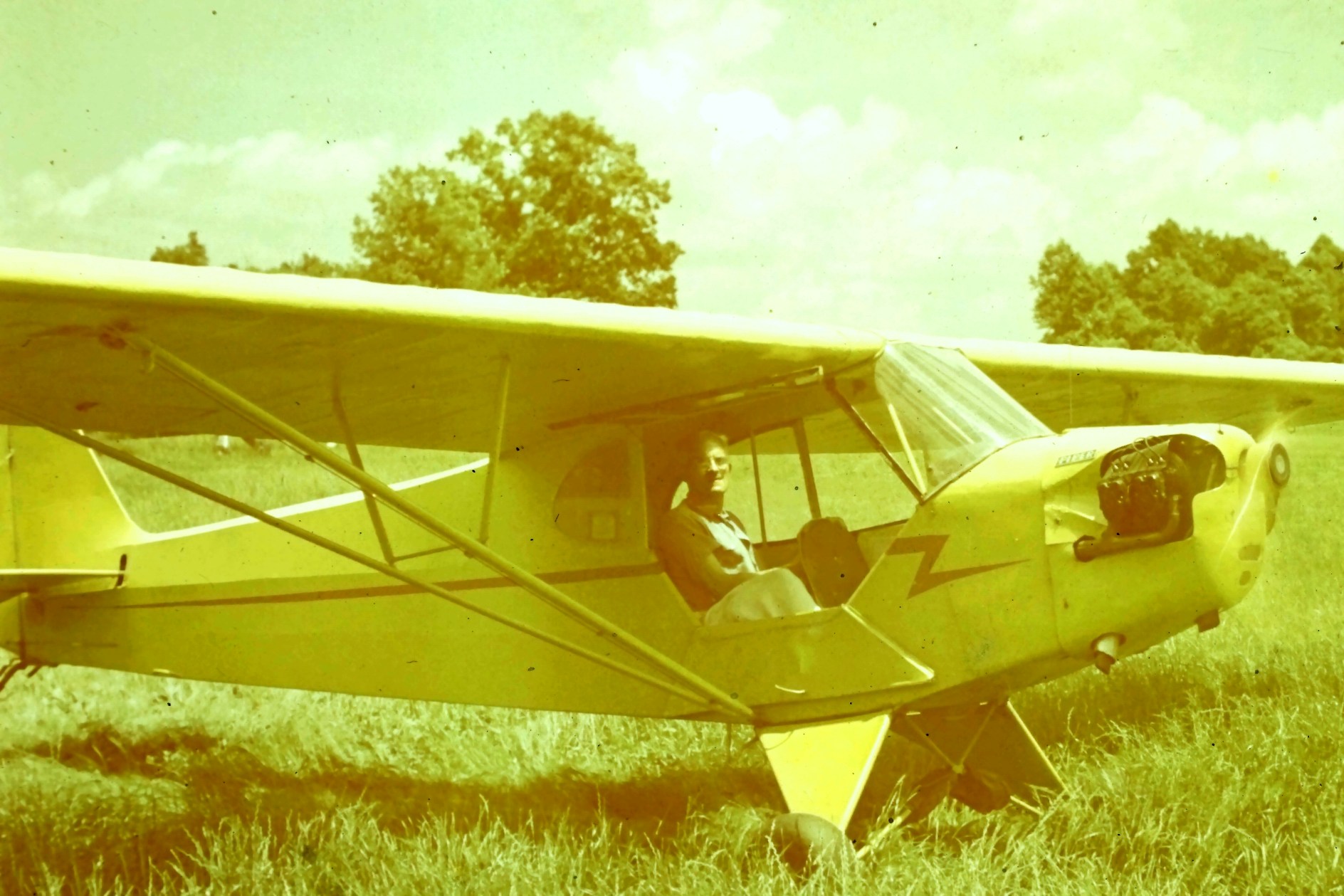
A circa 1949 photo (courtesy of Tony Beck) of Frank Beck in a Piper J3 Cub at Falls Church Airpark.
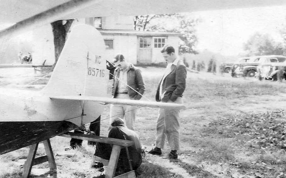
A circa 1949 photo (courtesy of Tony Beck) of Tom Pond & Don Kyker (standing) & Bill Burnett (behind the saw horse) with the tail of a Champ & the Falls Church Airpark office in the background.
Ralph Hooverra recalled, “My father learned to fly at Falls Church Airpark, 10/11/1949, 6 weeks before my birth.
We went to school at Graham Road Elementary just across the street & would pretend to be flying while watching the airplanes from the swing-set.
My father obtained a commercial license before his young family stopped his flying in 1952.”
The January 1951 Washington Local Aeronautical Chart (courtesy of Tim Zukas)
depicted Falls Church Airport as having a 2,500' unpaved runway.
The 1951 Washington Sectional Chart (courtesy of Mike Keefe) depicted Falls Church Airport as having 2 runways,
with the longest being a 2,800' unpaved strip.
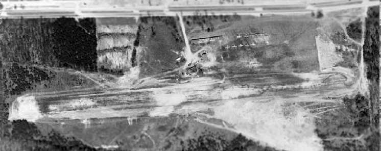
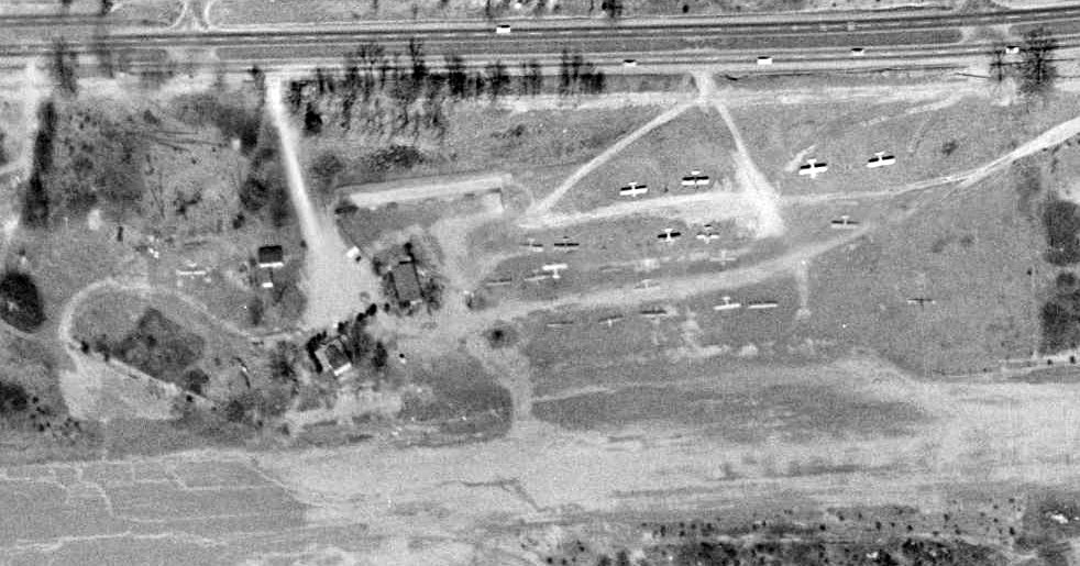
A 7/5/51 USGS aerial view depicted Falls Church Airpark as having 2 unpaved runways, several buildings, and a total of 17 light aircraft parked on the northeast side of the field.
A closeup from the 7/5/51 aerial photo, showing the hangar on the north side of the field with “Falls Church Airpark” painted on its roof,
and several of the light aircraft parked on the field.
David Farrell recalled, “I was in the Civil Air Patrol. [In] the Civil Air Patrol building I flew the BLUE BOX [Link Trainer].
The J-3 Cub behind the building [in the photo above] was my first airplane to fly at 16.
I checked out in an L-16 which I believe is the other aircraft in the aerial photo next to the building.
That J-3 finally 'bit the dust' & I joined a flying club that had a Taylorcraft (1st aircraft to the left, 1st row from the hangars) and that is the aircraft that I flew up to getting my private [pilot's license].
I had a girlfriend in Hanover PA & used to fly up to visit her in that plane. I taught her how to prop it as it had nothing electrical but a magneto.”
The 1951 USGS topo map depicted Falls Church Airport as having a single unpaved east/west runway, with a few small buildings on the north side.
Merton Meade recalled, “I went to Falls Church Airport many times. It never was paved & had 2 runways which were nearly parallel.
There indeed was a Mooney dealer at Falls Church & they actually rented the single seat Mooney Mite.
After a couple of wheels up landings, they attached a cowbell to the wee flag
that waved back & forth in front of the pilot's face as a gear warning device. THAT got your attention!
Seems to me a man called Ash Rossen was the operator there.”
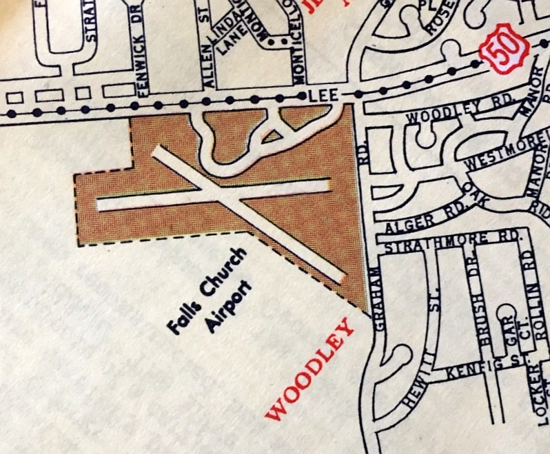
A 1952 street map (courtesy of Kevin Walsh) depicted Falls Church Airport as having 2 runways.
Lifelong Northern VA resident Mike Keefe recalled, "In 1953, I joined the Civil Air Patrol at that airport [Falls Church].
It had a 2,800' dirt runway, grass tie downs, a couple of flimsy hangers,
and a small wooden building that housed an Army Air Force Link Trainer.
My very first airplane ride was in that Link Trainer."
Former air traffic controller Andrew Pitas recalled, “In the mid-1950s
I had a Navy Twin Beech take off from NAS Anacostia in IFR weather who encountered engine trouble.
He was several miles west of National Airport when he declared an emergency
with a request we get him to the nearest airport.
I radar-vectored him into the Falls Church Airport for a safe landing.
They had to take the wings off in order to get the airplane onto a trailer to get it out of there.”
Jim Crabtree recalled, “In 1954 the Falls Church Airpark was quite busy with weekend pilots. They had turkey shoots there & other fundraising activities.
There was a scrapped military plane (something like a twin Beech) we played on. It was parked by the wooded south side of the runway. Great fun.”
Jon Eckert recalled, “I was in the Civil Air Patrol Squadron at the Falls Church Airpark.
It was a great squadron to be in & Fall Church Airpark was a great place to learn to fly.
I can attest to that as my father soloed me out there in a J-3 owned by the CAP on 5/17/55.
All landings were full stop because of the trees on both ends, runway length & runway slope.
The Blue Box (Link) was great too. It was not certified for instruction so we all could play with it & learn about instrument flying.
Many days we spent the whole day flying the Link. We also had an unlicensed Stearman.
It ran like a top & we would sneak a taxi ride when no one was around.
When we got tired of that & had 25¢ for a gallon of gas, we'd take turns flying the Cub.”
Tony Beck recalled, “Falls Church Airport... Dad (Frank Beck) and a friend of his (Clarence 'Pappy' Fathergill) based their 1939 Cub there.
They bought it roosting in some trees, cheap, and rebuilt it. Dad also had a Waco UPF-7 at Falls Church.
Dad's parents & Pappy's mom lived on Graham Road, practically right at the east end of the runway.
Dad said that Ash Rossen looked at becoming a dealer for the new Johnson Rocket, but they needed more runway than he had, so he picked up Mooneys instead.
My first flight was out of Falls Church, in a Cub. I couldn't have been more than 3 years old.
Dad put my brother & me in the back seat (my brother is 11 months younger) and we went flying up the Potomac with the door open.
I remember that flight, which would have been about 1955.
Falls Church was a neat place. I remember there was the skeleton of a big Stinson sitting out beside the office, which was an excellent Jungle Gym.”
In the late 1950s, several aircraft 'orphaned' by the closure of nearby Beacon Field & Alexandria Hybla Valley Airport were relocated to Falls Church.
Robert Everett recalled, "I worked at Falls Church Airpark as a line boy in 1958-59 before going into Air Force.
I was also in the Civil Air Patrol there 1957-59.
CAP had a small building on the right of the road as you entered & had a couple of L-15s of L-16s & a Link Trainer.
The CAP squadron was good to belong to as many of the kids' fathers were flying officers in various services
and when we wanted to go anywhere all the dads needed to do was go check out a C-47 & take the entire cadet squadron anywhere we needed to go.
I went to England AFB for the 1958 Fire Power Demonstration, to summer encampments & to Loch Haven, PA to the Piper factory."
Robert continued, "There was also an old house that served as both an office & snack bar.
The airport manager was named Bruce Walton & he had told me in 1959 that the field would be closing & soon be developed.
I remember the cheeseburgers & beer after work.
There were about (it seemed) 75-80 planes based there including 'Little Butch', the clip-wing monoplane that won all of the aerobatic awards & is now in the Smithsonian.
There were 2 runways & if you consider the main to be a 9/27,
then the auxiliary runway would be about a 13/21 intersecting Runway 27 between 1/2-3/4 down the field & terminating at the intersection.
They had a gas pump & several mechanics working there & also did some painting. I think that they had a Mooney dealer there also.
The 27 runway had a nasty down slope & on hot summer days the Cubs & Taylorcraft had to do downwind landings as they would float too bad to land.
I remember that Author Godfrey landed his DC-3 there once."
The Aerodromes table on the 1960 Washington Sectional Chart described Falls Church Airport as having 2 turf runways, with the longest being 2,800'.
The remarks also said "Hazardous - use at own risk. Strips muddy. East blocked trees."
The last photo which has been located showing Falls Church Airpark was a 1/26/60 USGS aerial view (from the Fairfax County Historical Imagery Viewer),
showing the 2 unpaved runways & several buildings.
A closeup of Falls Church Airpark from the 1/26/60 USGS aerial view (from the Fairfax County Historical Imagery Viewer)
depicted 20 light single-engine aircraft parked on the northeast side of the field.

The last aeronautical chart depiction which is available of Falls Church Airpark was on the 1960 Washington Local Aeronautical Chart.
It depicted Falls Church Airpark as having a 2,800' unpaved runway.
Falls Church Airpark was apparently closed at some point between 1960-61,
as it was no longer depicted on the 1961 Washington Local Aeronautical Chart (courtesy of Mike Keefe).
It had been crowded out of existence by the surrounding suburban development.
A 1962 aerial photo showed that the Falls Church Airpark hangar had been removed.
The east end of the former airfield was still clear, but apartment buildings had been constructed over the west side of the property.
Falls Church resident Mark Sublette recalled, “It was being converted into the Loehmann's Plaza Shopping Center in the mid-1960s.
I recall it just before [the shopping center] opened in 1967.
We went go-karting there one Saturday afternoon with the parking lots just empty of vehicles.”
A 1976 aerial photo (from the Fairfax County Historical Imagery Viewer) showed all traces of Falls Church Airpark had been removed.
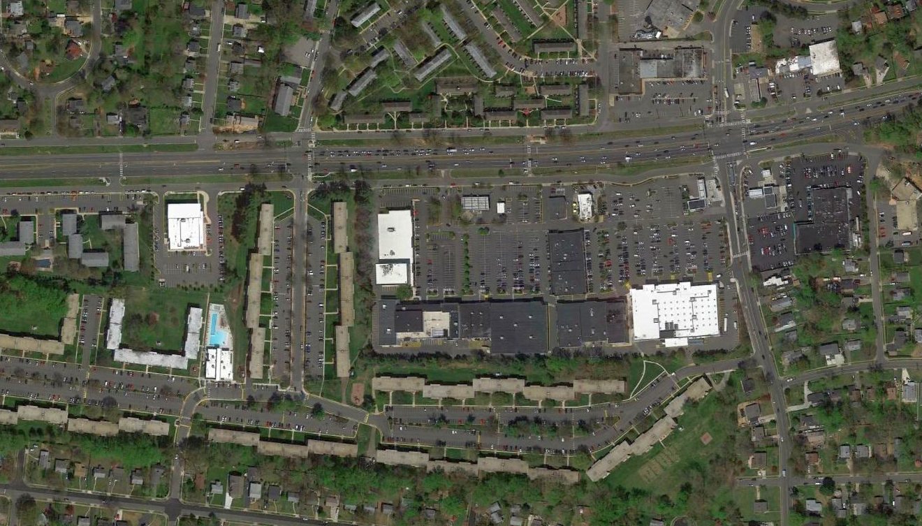
A 2016 aerial view of the site of Falls Church Airport, now Loehman's Plaza Shopping Center.
Not a single trace appears to remain of the former airport.
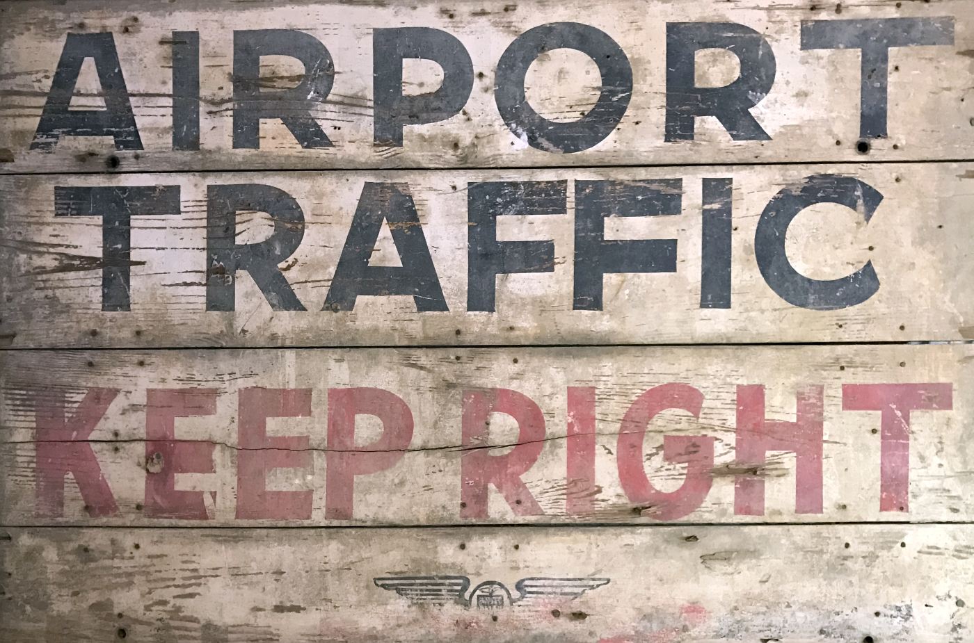
A 2017 photo by Antonio Chaves of a “a sign that is supposed to be from the Falls Church Airpark.
It is 48 x 72 & weighs a ton. The provenance is impeccable. I bought it from the Dunn family. It is indeed intriguing.”
The site of Falls Church Airpark is located southeast of the intersection of Arlington Boulevard & Allen Street.
____________________________________________________
Centreville Airport (VA16), Centreville, VA
38.879, -77.485 (Southwest of Dulles Airport, VA)

A 1960 aerial view (from the Fairfax County Historical Imagery Viewer) depicted Centreville Airport as having 2 grass runways.
A 3/12/52 aerial view of the eventual site of Centreville Airport did not depict any sign of an airfield yet;
the property was farmland without any trace of a runway.
According to the book "Virginia Airports" by Vera Rollo & Norman Crabill (published by the VAHS),
Centerville Airport "was opened in 1954 by C. L. Caldwell with 2 turf runways. It seems to have been a personal airport."
Centreville Airport was not depicted on the 1956 USGS topo map.
The earliest depiction which has been located of Centreville Airport was a 1957 aerial view.
It depicted Centreville as having 2 grass runways.
No aircraft were visible on the field, but there were several buildings along the east side.
Centreville Airport was depicted in an unchanged configuration in aerial photos from 1960, 1962, and 1963.
Jim Crabtree recalled, “In 1960-62 I dated a girl who lived on Braddock Road north of Centreville across the street from the grass strip owned by Col. Caldwell.”
Centreville Airport was not depicted on the 1963 USGS topo map.
Centreville Airport was depicted in an unchanged configuration in a 1964 aerial photo.
Centreville Airport was not yet depicted on the April 1965 Washington Local Chart.
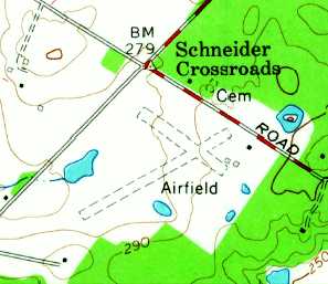
The 1966 USGS topo map depicted Centreville Airport as having a unpaved runways, labeled simply as "Airfield".
Herb Dunkle recalled, “Centerville Airfield... I flew out it of with Colonel L. Caldwell as a 16-18 year old kid in 1966-68 in Mr. Caldwell's Piper PA-24 Tripacer.
Mr. Caldwell was the Commander of the USAFR Civil Air Patrol Dulles Composite Squadron in the mid-1960s which was the Official Search & Rescue group for Northern Virginia Area.
He was a great teacher.”
Centreville Airport was not yet depicted on the 1970 Washington Sectional Chart.
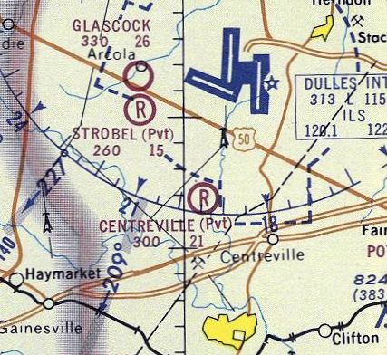
The only aeronautical chart depiction which has been located of Centreville Airport was on the 1971 Washington Sectional Chart (courtesy of Ed Francis).
It depicted Centreville as a private airfield with a 2,100' unpaved runway.
Centerville Airport was no longer depicted on the September 1972 Local Aeronautical Chart.
Scott Keating recalled, “I grew up in Centreville & remember driving by the 'airport' in the 1970s.
As best I can remember the field was apparently just a private strip for the homeowner,
but he had the power lines that surrounded the property well marked with orange balls,
and had a large wind tetrahedron in the front yard - it was always well maintained.”
Centreville Airport was depicted in an unchanged configuration on a 1974 aerial photo.
Centerville Airport was not depicted on the 1974 Fairfax County parcel map (courtesy of Dallam Oliver-Lee).
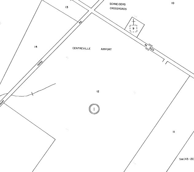
The earliest appearance of Centreville Airport on the Fairfax County parcel maps which has been located was on the 1975 parcel map (courtesy of Dallam Oliver-Lee).
Centreville Airport was depicted in an unchanged configuration in aerial photos from 1979 & 1981.
The earliest directory reference to Centreville Airport which has been located was in the 1982 AOPA Airport Directory (courtesy of Ed Drury),
which described it as a private airfield consisting of 2 turf runways: 2,100' Runway 6/24 & 1,1000' Runway 15/33.
Centerville Airport was located a mere 4 miles from the end of Dulles International Airport's Runway 1R, well within the inner ring of Dulles' Class B airspace
(which must have made flight operations from the little field quite interesting!).
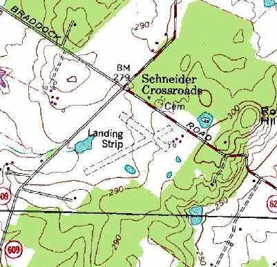
The 2 runways of Centreville Airport were depicted on the 1983 USGS topo map, labeled simply as "Landing Field".
Scott Keating recalled, “During the 1980s it slowly started to disappear, but was always recognizable.”
Vincent Agnelli recalled visiting Centreville Airport in 1984, “C.L. Caldwell - The 'C' in his name stood for Colonel which was his real name.
He was also a retired Colonel from USAF. He was a WWII fighter pilot. I really pressed him for stories. His first combat was at Midway. Can you imagine?
He also said he was flying a fighter plane before he had a driver’s license!
If I remember correctly he flew a P-40. He told me he flew off of Midway Island & got shot down.
Turned out he had just beat prostate cancer & was on the mend but what a tough guy he was.
His family owned that land. It was 180 acres & it was all his. At the time he was asking just over a million dollars for it.
He would have got it right away except the county rezoned not to have city sewer & water which made potential developers shy away.
I remember Mrs. Caldwell too. Feisty & smart. The house was so old the floor boards were warped down & they still had a wood stove in the kitchen.
Nicer folks to a stranger you never have met I can assure you. On the property he had an open hangar that could have accommodated 2 planes.
He had a gas pump & a machine shop building. The planes were gone…he had long since stopped flying.
He said he used to fly air-mail to New York & he used to charter folks a lot.”
The last photo which has been located showing Centreville Airport still intact was a 1997 aerial view (from the Fairfax County Historical Imagery Viewer).
Although the runways remained clear, there was no sign of any recent avaition use.
The last appearance of Centreville Airport on the Fairfax County parcel maps which has been located was on the 2000 parcel map (courtesy of Dallam Oliver-Lee).
Centreville Airport was no longer depicted on the 2001 Fairfax County parcel map (courtesy of Dallam Oliver-Lee);
instead the site was labeled “Pleasant Valley Properties”.
According to J. Lartz, “Fairfax County Park Authority bought the land in 2001.”
However a 2001 aerial photo showed land being cleared for new houses along the eastern portion of the airport property.
Paul Freeman drove by the site of Centreville Airport & saw that newly-constructed housing was surrounding the airfield.
It appeared as if the airfield property was also about to be redeveloped as a housing development.
A 2002 USGS aerial photo showed that the eastern portion of both runways
had been covered by a newly-constructed street with several new houses.
According to J. Lartz, “The land next to it was developed with million-dollar homes in 2002 & 2003.”
According to the 2003 book "Virginia Airports", "The site has been acquired by the Hunter Development Company."
Inexplicably, as of 2004, Centreville was still listed with the FAA as an active private airfield, with the owner listed as David Hunter.
This seems quite strange, given that the 2002 photo shows that the field had undoubtedly ceased to function as an airfield even by that point.
Scott Keating reproted in 2005, “I visited the site last October & was amazed to see it was completely gone, overrun with houses everywhere.
The orange balls were still on the power lines though.”
As of 2006, the Centreville Airport was no longer listed in the FAA Airport/Facility Directory as an active airfield.
Vincent Agnelli reported in 2008 that the site of Centreville Airport now is occupied by a housing subdivision named Victoria Crossing.
A 6/20/11 USDA aerial photo (courtesy of Dallam Oliver-Lee) still showed the recognizable outline of both runways along the western portion of the site of Centreville Airport.
The regional farm attraction of Cox Farms sits just across the road to the northwest.
The site of Centreville Airport is located just south of the intersection of Braddock Road & Pleasant Valley Road.
Thanks to Charlie for pointing out this airfield.
____________________________________________________
Herndon Nike Missile Battery W-83 Launch Site, Herndon, VA
38.992, -77.327 (Northwest of Washington, DC)
A December 1956 aerial view looking northwest at the Herndon Nike missile launch site (courtesy of Thomas Page).
The purpose of this military base was to shoot down incoming aircraft.
It is included here due to its significance in Cold War history.
Herndon Site W-83 was one of a network of 13 Nike missile batteries that surrounded Washington.
The others were located in Davidsonville, Bay Bridge, Croom, Brandywine, Waldorf,
Accokeek, Pamonkey, Lorton, Pohick, Rockville, Gaithersburg & Laytonsville.
The Washington-area Nike batteries have great historical significance, as when they first became operational in 1953,
they were the very first surface-to-air guided missile system to enter operational service in the world.
Each Nike battery consisted of 2 separate facilities: a Launch Area & an Integrated Fire Control Area.
The layout of all Nike sites was characteristic in that the launch site was situated 1-3 miles “downrange” from its Integrated Fire Control Area,
along the axis toward the anticipated targets,
such that the radars at the IFCA would have a line-of-sight toward both the missiles & the target.
Herndon Nike Launch Site W-83 was not yet depicted on a 1953 aerial photo (from the Fairfax County Historical Imagery Viewer)
To build Herndon Site W-83, in 1955 the US Government obtained property on Utterback Store Road (to be used for the launch site),
as well as an additional 12 acres from the dairy farm of Mark Turner (to be used for its companion Integrated Fire Control Area).
Herndon Site W-83 was activated in 1955.
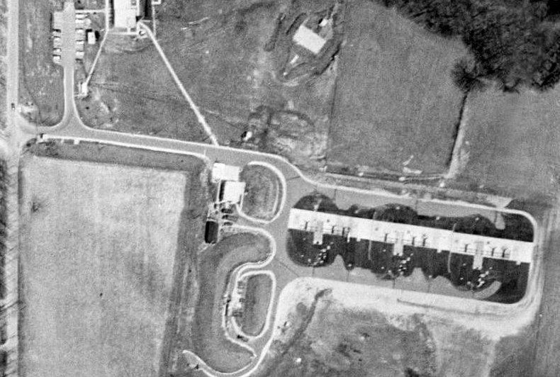
The earliest depiction which has been located of Herndon Site W-83 was a December 1956 aerial photo (courtesy of Thomas Page).
It showed the Nike missile launchers on the east side of the facility, and an earthen berm surrounding the missile fueling area on the west side.
Michael Binder reported, “The fueling area [was] where the handling of drums of fuming red nitric acid & kerosene
was deemed to be the most hazardous surface activity conducted on a regular basis at a Nike-Ajax site.”
The barracks was seen in the background, on the northwest side of the facility.

An undated photo of 2 Nike Ajax missiles on their launcher.
The Herndon Nike site operated the first-generation Nike Ajax missile.
The Nike Ajax missile was huge: each one stood 34' tall & weighed 2,400 pounds.
It had a range of 25 miles & a maximum speed of Mach 2.3.
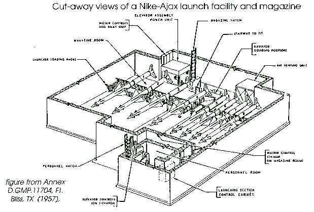
A cutaway view of a typical Nike Ajax Launch Area underground magazine.
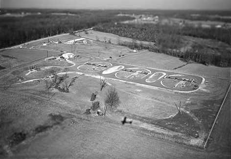
A 1957 aerial view of the Herndon Nike Launch Site showed its full complement of 12 Nike-Ajax missile launchers
(several of which appeared to have missiles mounted on them).
A 1960 USGS aerial view (from the Fairfax County Historical Imagery Viewer) depicted the Herndon Nike Launch Site.
Five of the Washington area batteries were later converted to fire the 2nd-generation Nike Hercules missile.
Herndon Site W-83 was not among the Nike sites upgraded with the Nike Hercules missile, and it was closed in 1962.
A 1962 aerial view showed that the above-ground Nike launchers had been removed.
The hatches for the 3 underground missile magazines were still visible, connected by an east/west concrete strip.
The former Nike Launch Area on Utterback Store Road was turned over to Fairfax County in 1975.
The last photo which has been located showing the Herndon launch site mostly intact was a 1976 aerial view (from the Fairfax County Historical Imagery Viewer).
The above-ground missile launchers & their rails had been removed, but the missile magazine hatches remained.
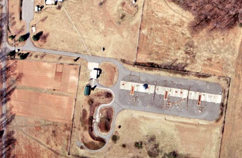
A 1979 aerial view of the Herndon Nike Launch Site showed that the area of the launchers had been completely sanitized,
with the missile magazine hatches & concrete base having been removed.
The only remaining trace of the missile installation was the earthen berms on the west side of the facility, previously surrounding the missile fueling area.
The former barracks on the northwest side of the launchers had also been removed at some point between 1974-79.
Paul Freeman visited the Herdon Nike Site W-83 in 2000.
The Launch Area is located on the east side of Utterback Store Road,
just north of Route 7, and immediately south of Forrestville Elementary School.
The area previously containing the barracks has become the site of Forrestville Elementary School, and not a single Nike building remains.
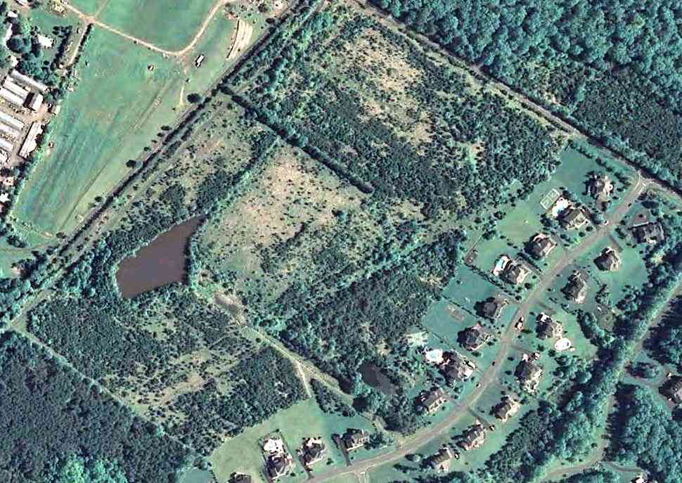
Most of the property surrounding the location of the launchers has become "Great Falls Nike Park", a complex of athletic fields.
On the southwest portion of the site remains a rectangular raised earthen berm, which previously surrounded the missile fueling area.
No other physical trace remains of the launchers, but the ground of this area is noticeably higher in elevation than the surrounding area,
which makes it appears likely that the underground magazine was left intact & simply buried.
This contention is supported by accounts from local residents.
Michael Binder reported, “It is probable that the missile magazines were excavated & the resulting voids filled in before the athletic facilities were constructed on top.”
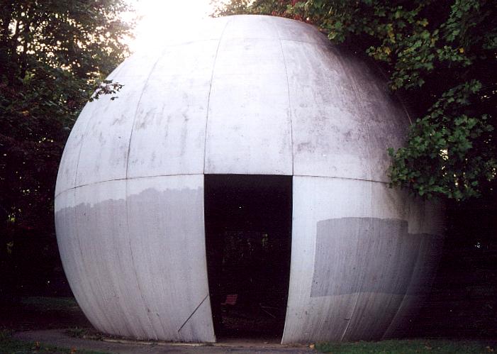
A September 2000 photo by Paul Freeman of a radome at the site of the Herndon Nike launch site.
This may be the former HIPAR radome, relocated from the Herndon Nike Integrated Fire Control Site.
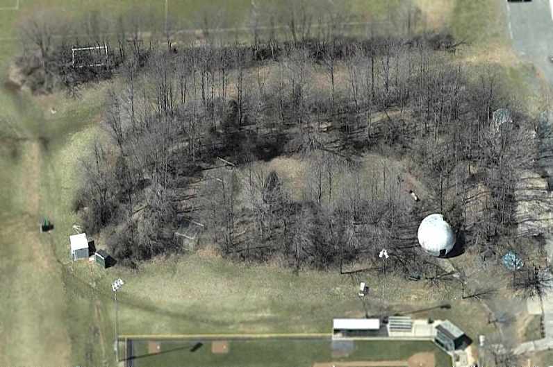
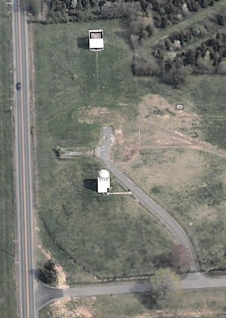
A circa 2005 aerial photo looking west at the earthen berm & radome which remains at the site of the Herndon Nike Launch Site.
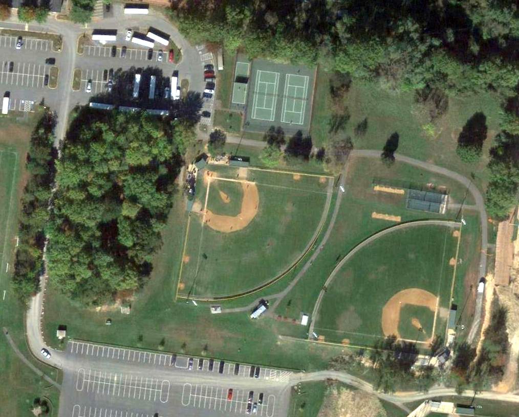
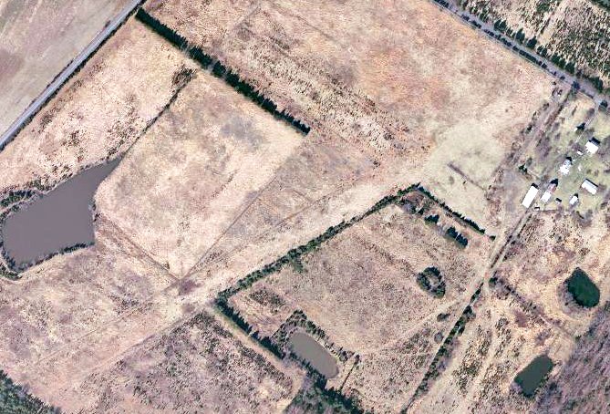
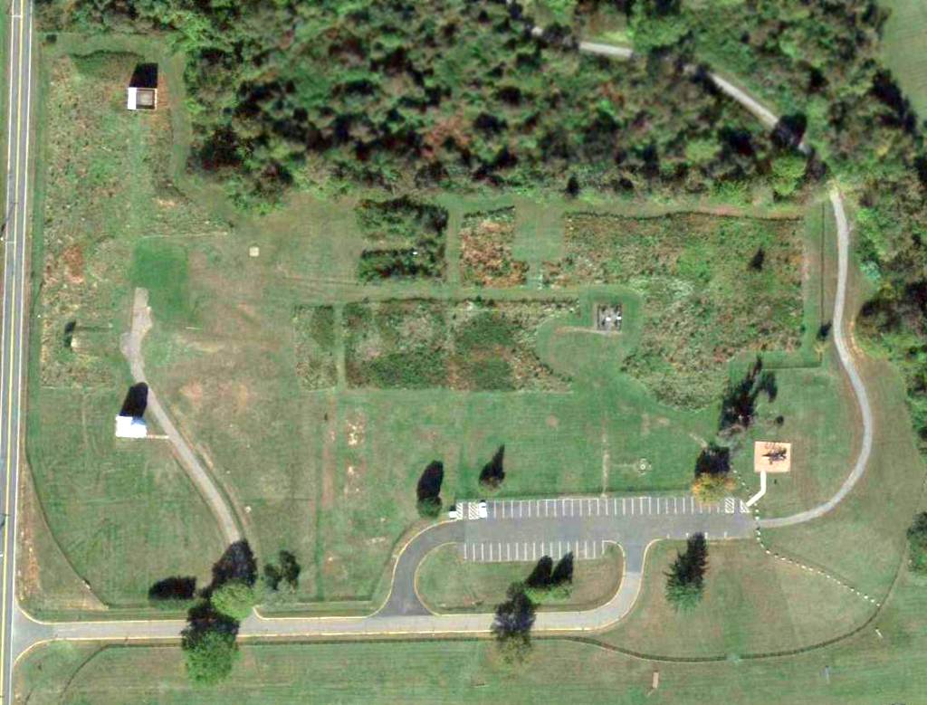
A 10/12/12 aerial photo of the location of the Herndon Launch Area.
The cluster of trees on the west side cover the earthen berms which formerly surrounded the missile fueling area,
and tennis courts & ballfields cover the site of the missile launchers.
Thanks to Tom Page for information about the Herndon site.
See also:
http://www.nikenuke.net/nike/text/nikefrm1.html
http://www.jps.net/ethelen/loc-v.html#Virginia
____________________________________________________
Herndon Nike Missile Battery W-83 Integrated Fire Control Site, Herndon, VA
38.995, -77.313 (Northwest of Washington, DC)
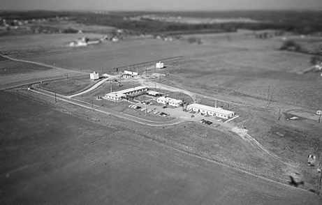
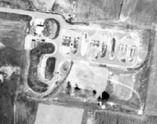
A December 1956 aerial view looking northwest at the Herndon Nike Integrated Fire Control Site (courtesy of Thomas Page),
showing the barracks on the east side of the facility, and the radar towers on the west side.
This is the companion site to the Herndon Nike Launch Site.
It is included here due to its significance in Cold War history, and its remarkable state of preservation.
Herndon Site W-83 was one of a network of 13 Nike missile batteries that surrounded Washington.
The others were located in Davidsonville, Bay Bridge, Croom, Brandywine, Waldorf,
Accokeek, Pamonkey, Lorton, Pohick, Rockville, Gaithersburg & Laytonsville.
The Washington-area Nike batteries have great historical significance,
as when they first became operational in 1953,
they were the very first surface-to-air guided missile system to enter operational service in the world.
Each Nike battery consisted of 2 separate facilities: a Launch Area & an Integrated Fire Control Area.
The layout of all Nike sites was characteristic in that the launch site was situated 1-3 miles “downrange” from its Integrated Fire Control Area,
along the axis toward the anticipated targets,
such that the radars at the IFCA would have a line-of-sight toward both the missiles & the target.
Herndon Nike Integrated Fire Control Site W-83 was not yet depicted on a 1953 aerial photo (from the Fairfax County Historical Imagery Viewer)
To build Herndon Site W-83, in 1955 the US Government obtained 12 acres
from the dairy farm of Mark Turner (to be used for the Integrated Fire Control Area)
and an additional site on Utterback Store Road (to be used for the Herndon Nike Launch Site).
Herndon Site W-83 was activated in 1955.
The earliest depiction which has been located of Herndon Site W-83 was a December 1956 aerial photo (courtesy of Thomas Page).
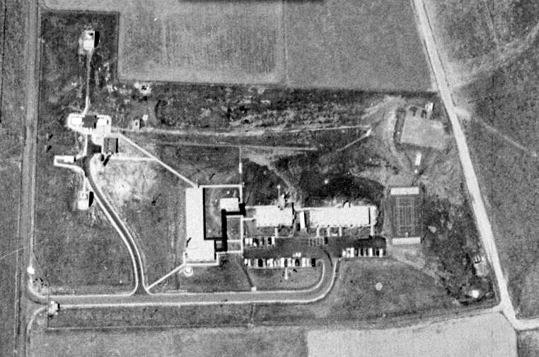
A 1957 aerial view of the Herndon Nike Integrated Fire Control Site showed it during its operational phase,
with several radar towers along the west side, and a large number of cars in the parking lot.
A 1960 USGS aerial view (from the Fairfax County Historical Imagery Viewer) depicted the Herndon Nike Integrated Fire Control Site.
Five of the Washington area batteries were later converted to fire the 2nd-generation Nike Hercules missile.
Herndon Site W-83 was not among the Nike sites upgraded with the Nike Hercules missile, and it was closed in 1962.
A 1962 aerial view appeared to show the IFCS after being closed,
as their were no cars in the parking lot, but the facility remained otherwise intact.
The Army Map Service took possession of the Herndon Nike site in 1962
and operated unclassified satellite operations from there (according to Burt Sharp).
Their operations conducted research in the field of geodesy (eventually supporting the development of the GPS navigation system).
An astronomy observatory dome was constructed on top of the southern radar tower.
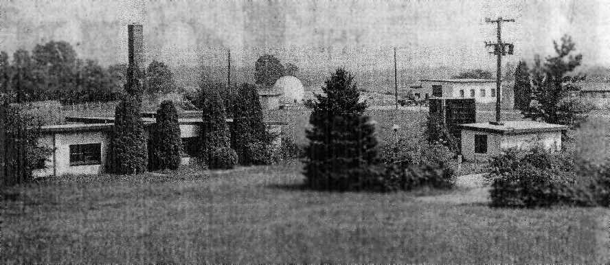
A 1975 photo of the Herndon Nike Integrated Fire Control Site
(from the Washington Star newspaper, courtesy of the Fairfax Library, via Chris Barbuschak).
According to Chris noted, the dome in the center is the HIPAR radome
(which eventually ended up being relocated to the park which occupies the former launch site).
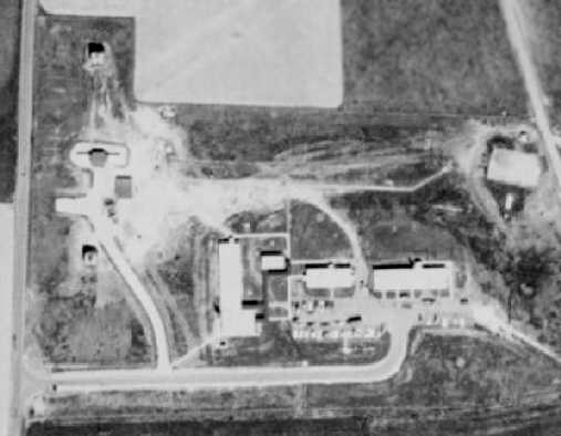
A 1976 USGS aerial view (from the Fairfax County Historical Imagery Viewer) depicted the Herndon Nike Integrated Fire Control Site as having a considerable number of cars in its parking lot.
A 1979 aerial view of the former Herndon IFCS site still showed it being used, with a significant number of cars in the parking lot.
The former Integrated Fire Control Area on Springvale Road was operated by the Defense Mapping Agency until 1993.
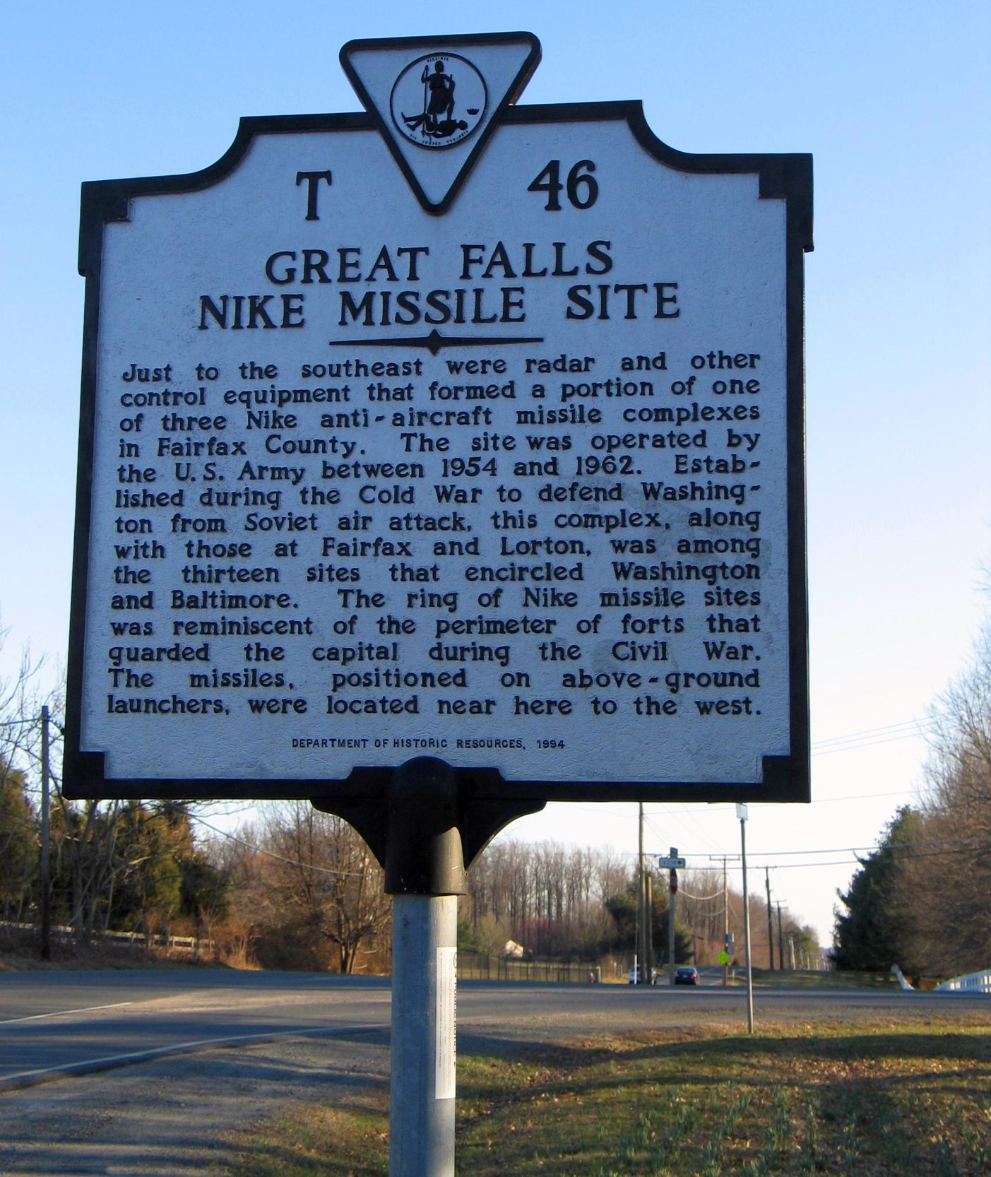
A 1994-2018 photo of a historical plaque near the Herndon Nike Integrated Fire Control Site.
Paul Freeman visited Site W-83 in 2000.
The Herndon Integrated Fire Control Area was the only one of the 8 Washington area sites that existed almost completely intact.
It is located on the east side of Springvale Road, north of Route 7 & south of Old Georgetown Pike.
It sat on very expensive real estate, and is now surrounded by housing developments.
The Integrated Fire Control Area consists of a group of small buildings -
barracks, mess hall, offices, still surrounded by a barbed wire fence with a locked gate.
A guard shack sat behind the gate at the entrance on Springvale Road.
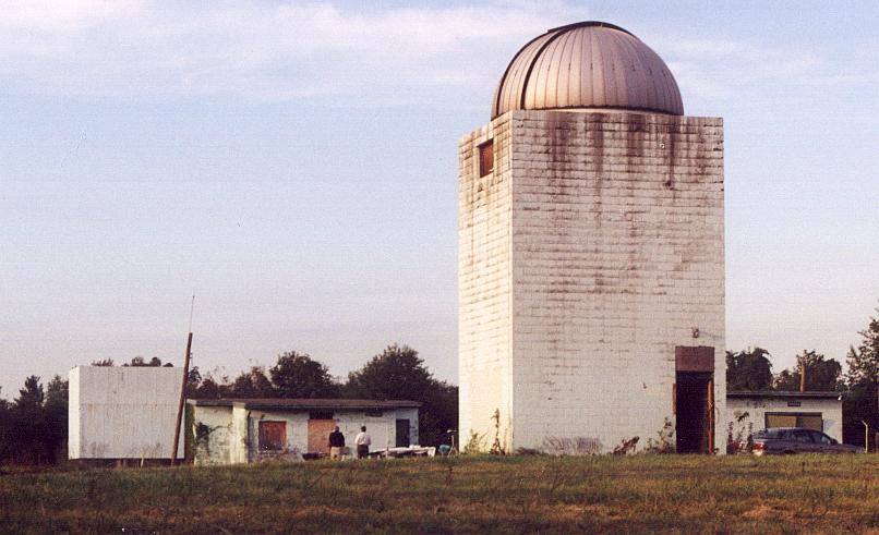
A September 2000 photo by Paul Freeman of towers originally used to mount the Nike target tracking & missile guidance radars,
at the Site W-83 Integrated Fire Control Area.
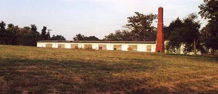
A September 2000 photo by Paul Freeman of former barracks at Site W-83 Integrated Fire Control Area, (which have since been leveled).
The primary remaining features which denote the site as a Nike installation
are 2 radar towers still standing on the front of the property along Springvale Road.
These towers once mounted the High-Power Acquisition Radar (HIPAR) & Missile Tracking Radar.
The radomes have long since been removed from both towers, but one of the radomes has been moved & reinstalled
at the Great Falls Nike Park (location of Site W-83's Launch Area) - see description below.
Although the entrance gate of the Integrated Fire Control Area is usually locked,
Paul Freeman found the gate unlocked & was able to drive into & explore the facility in 9/00.
A group of astronomy enthusiasts was having a meeting at the site, which was the reason for the unlocked gate.
This group had received permission from the Fairfax County Park Authority (which was granted the property by the federal government)
to redevelop the site as an astronomy educational facility.
They had received permission to demolish all of the historic buildings on the east side of the installation,
with the only trace of the facility's historical significance that would be allowed to remain would be the 2 radar towers,
which will be reused as mounts for telescopes.
Indeed, this was carried out, as a drive by the facility in early 2002 confirmed that the all of the barracks & other support buildings had been leveled,
with only the radar towers remaining.
Given that it is was almost perfectly preserved, and in such close proximity to Washington,
it was a great shame to loose such a significant historic asset of the Cold War.
Apparently, neither the Park Authority nor the astronomy group cared about this facility's historic significance, or its educational potential.
In our society today, every special interest group has its own narrow agenda,
and the only history considered "valid" is that within the specific interest of each group.
A circa 2005 aerial photo looking north at the former Herndon Nike radar towers.
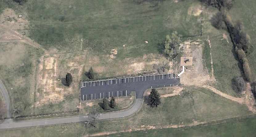
A circa 2005 aerial photo looking north at the site of the Herndon Nike IFC barracks, after their removal.
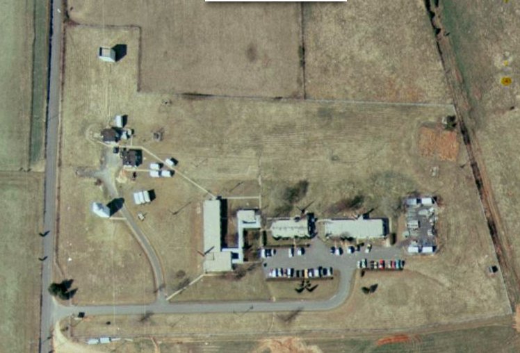
A 10/12/12 aerial photo of the remains of the Herndon Integrated Fire Control Area.
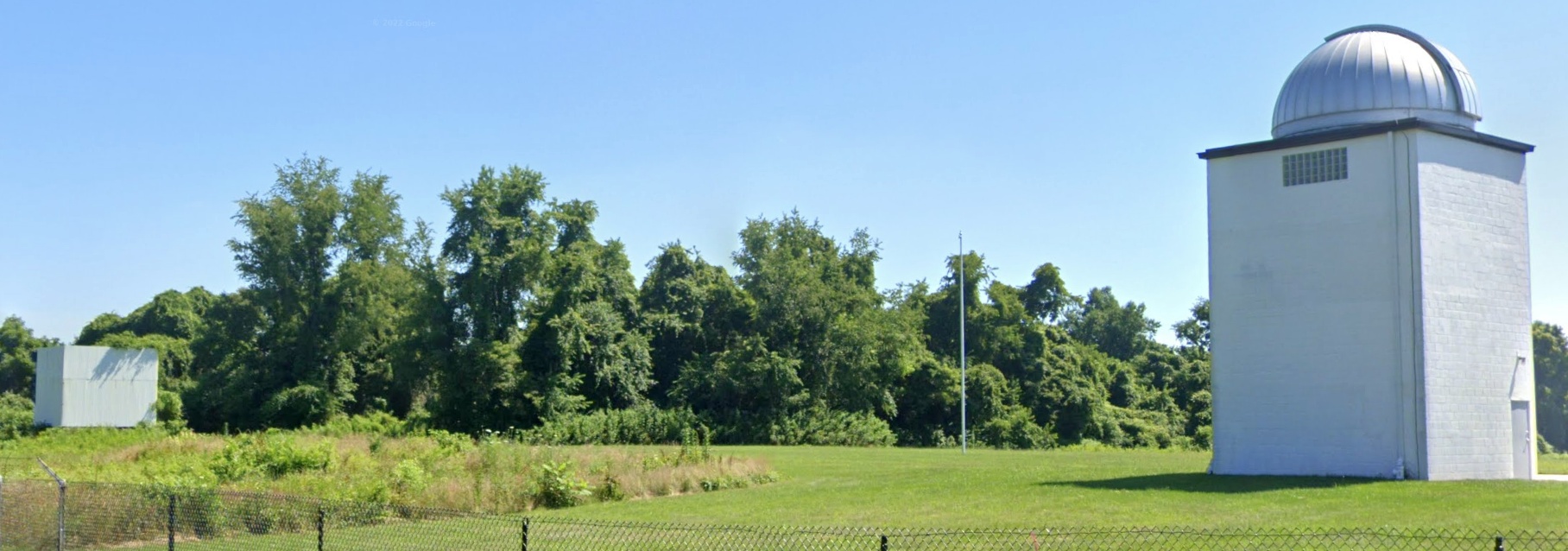
A 2022 photo looking northeast at 2 former Nike radar towers, the only remains of the Herndon Integrated Fire Control Area.
Thanks to Tom Page for information about the Herndon site.
See also:
http://www.nikenuke.net/nike/text/nikefrm1.html
http://www.jps.net/ethelen/loc-v.html#Virginia
____________________________________________________
Or if you prefer to contact me directly concerning a contribution (for a mailing address to send a check),
please contact me at: paulandterryfreeman@gmail.com
If you enjoy this web site, please support it with a financial contribution.
____________________________________________________
This site covers airfields in all 50 states.