Abandoned & Little-Known Airfields:
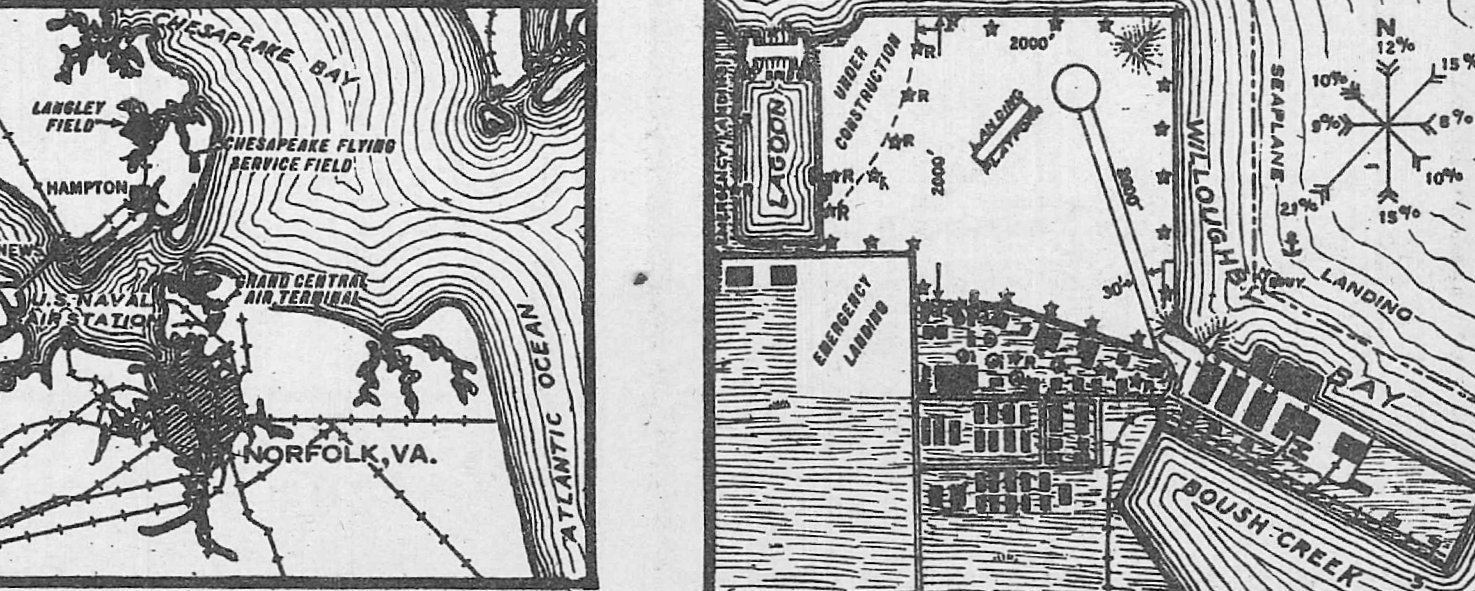
Virginia: Norfolk area
© 2002, © 2022 by Paul Freeman. Revised 10/18/22.
This site covers airfields in all 50 states: Click here for the site's main menu.
____________________________________________________
Please consider a financial contribution to support the continued growth & operation of this site.
Cumberland Airport (added 11/26/21) - Dover Airport (revised 12/31/16) - Glenrock Airport (revised 5/8/20) - Monogram NAAS (revised 9/15/22)
(Original) Norfolk NAS / Chambers Field (revised 2/22/19) - Norfolk NAS Seaplane Base (revised 10/14/22)
South Norfolk Airport (revised 10/18/22) - Whitehurst NOLF (revised 6/21/19)
____________________________________________________
Cumberland Airport, Deep Creek, VA
36.703, -76.334 (Southwest of Norfolk, VA)
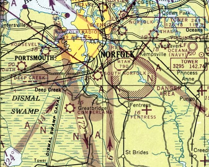
Cumberland Airport, as depicted on the April 1947 Norfolk Sectional Chart.
Photo of the airport while in use has not been located.
Cumberland Airport was evidently established at some point between 1946-47,
as it was not yet depicted on the October 1946 Norfolk Sectional Chart.
The earliest aeronautical chart depiction of Cumberland Airport which has been located was on the April 1947 Norfolk Sectional Chart.

The last depiction which has been located of Cumberland Airport was on the January 1952 Norfolk Sectional Chart.
It depicted Cumberland Airport as having a 2,700' unpaved runway.
Cumberland Airport was evidently closed (for reasons unknown) at some point in 1952,
as it was no longer depicted on the August 1952 Norfolk Sectional Chart.
A 1953 aerial photo showed Cumberland Airport presumably after it had closed.
It consisted of a single grass northeast/southwest runway, with 3 small hangars along the east side.
There were no aircraft visible on the field.
Cumberland Airport was was not depicted on the 1956 USGS topo map.
A 1963 aerial photo showed Cumberland Airport remained largely intact, with the runway remaining clear.
Two of the hangars had been removed at some point between 1953-63, but one remained.
The 1971 aerial view showed the runway & 1 remaining hangar of Cumberland Airport remained in the same fashion as seen in 1963.
A 1982 aerial view showed the last hangar of Cumberland Airport had been removed at some point between 1971-83,
but the runway remained clear.
A 1994 aerial view showed the site of Cumberland Airport remained clear.
A 2002 aerial view showed a road (Drumcastle Lane) & houses had covered the site of Cumberland Airport.
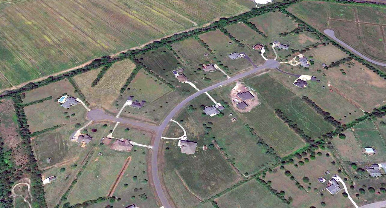
A 2018 aerial view looking northwest showed no recognizable trace remaining of Cumberland Airport.
____________________________________________________
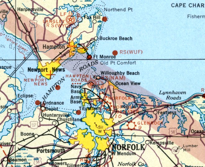
Norfolk Naval Air Station Seaplane Base, Norfolk, VA
36.947, -76.28 (Northwest of Norfolk, VA)
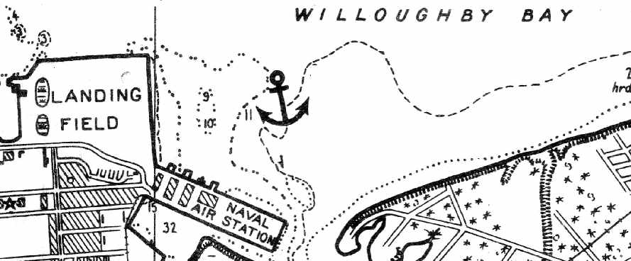
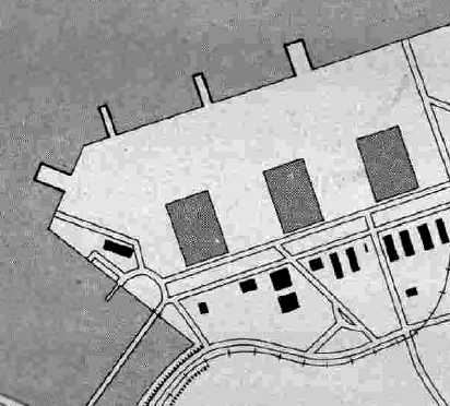
The Norfolk seaplane base, as depicted on the 1932 Washington-Hampton Air Navigation Map #4.
The “Naval Air Detachment, Naval Operating Base, Hampton Roads” was established in 1917,
with a complement of 5 officers, 3 aviators, 10 enlisted sailors, and 7 aircraft.
The aircraft, all seaplanes, were flown across the James River from Newport News,
and moored to stakes in the water until canvas hangars were constructed.
The new location offered sheltered water in an ice-free harbor, perfect for seaplane landings,
good anchorage on the beach front, accessibility to supplies from Naval Station Norfolk, and room for expansion.
Its mission was to conduct anti-submarine patrols, train aviators & mechanics, and run an experimental facility.
When the United States became involved in World War I, the size of the the Navy's air component was eagerly expanded.
The training of aircraft mechanics began in January 1918 at the Norfolk detachment & the first patrol was conducted 5 months later.
By now, the air detachment was recognized as one of the most important sources of trained naval aviators.
In recognition of its importance, on 8/27/18, the detachment became Naval Air Station Hampton Roads,
a separate station under its own commanding officer, Lt. Cmdr. P.N.L. Bellinger.
As World War I came to an end, the former NAS Hampton Roads saw erratic growth,
growing to nearly 167 officers, 1,227 enlisted men and 65 planes.
But, it was after the war that demobilization had threatened the future of naval aviation.
Within seven months of the war's end, Navy manpower fell to less than half its wartime highs.
On 7/12/21, the name was changed again under the command of Capt. S.H.R. Doyle, to NAS Norfolk,
with direct reporting to the Bureau of Aeronautics in Washington, D.C.
The earliest depiction which has been located of the Norfolk seaplane base
was on the 1932 Washington-Hampton Air Navigation Map #4.
The Airport Directory Company's 1933 Airport Directory (courtesy of Chris Kennedy)
described the Norfolk Naval Air Station as having a seaplane landing area
in Willoughby Bay to the east of the field.
An undated aerial photo looking southeast at Chambers Field from a 1934 Navy Aviation Chart (courtesy of Chris Kennedy)
showed the original seaplane base was visible behind the airfield.
A 1935 Navy Aviation Chart (courtesy of Chris Kennedy) depicted Chambers Field as a “Landing Field”,
with the buildings to the southeast being labeled “Naval Air Station”.
The earliest Sectional Chart depiction which has been located of the Norfolk seaplane base was on the October 1935 Norfolk Sectional Chart.
During World War II, Naval Air Station had a direct combat support role in the area of anti-submarine patrols.
President Roosevelt's response to the start of the war in Europe was the National Emergency Program of 9/8/39.
It resulted in fantastic growth for all Navy activities in the Norfolk area.
The combat support role began on 10/21/39,
when a 600-mile-wide Neutrality Zone was declared around the American coast.
Four Norfolk-based patrol squadrons, VP-51, VP-52, VP-53 and VP-54 were among the first units to enforce the zone.
The Hepburn Board had made recommendations to Congress in 1940 that would also double the size & workload of the station.
Since Chambers & West Fields were encroaching on the activities of the Naval Operating Base, it was decided to expand to the east.
East Camp, with an area of about 1,000 acres between the east side of Naval Station & Granby Street,
had been sold off by the Army at the end of World War I.
Congress authorized its repurchase in early 1940.
On June 29 of that year, a contract was signed with the Virginia Engineering Company for the expansion of the station.
The cost of expansion and construction was to reach more than $72 million.
Hangars, a new dispensary, 3 runways, magazine areas, warehouses, barracks and docking areas were patterned after similar existing airfields.
The plan was revised and approved by Capt. P. Bellinger, returning as commanding officer 20 years after first holding the job.
Bellinger insisted that as many structures as possible be permanent ones.
The air station was still largely composed of temporary hangars & workshops left over from World War I.
Many were unsafe & costly to maintain.
Some 353 acres were eventually reclaimed at a cost of $2.1 million.
Two large hangars, ramps for seaplanes, barracks, officer quarters and family housing were built.
This construction cut off Mason Creek Road & the Navy compensated the city by improving Kersloe Road between Hampton Boulevard & Granby Street.
Norfolk responded by renaming the road, Admiral Taussig Boulevard, in honor of the retiring commander of the Naval Operating Base.
In July 1940, the Federal government began dredging Willoughby Bay
and the Naval Air Station seaplane operating area at Breezy Point was constructed from reclaimed marshlands at the mouth of Mason Creek.
By the time President Roosevelt visited at the end of July,
the station was clearly reaching the point where it could support ships engaged in war overseas.
The July 1941 Norfolk Sectional Chart (courtesy of Chris Kennedy) depicted Chambers Field as well as the adjacent seaplane base.
In 1941, the possibility of U.S. involvement in the war looked more likely.
Construction of more new facilities was pushed forward to match increased requirements.
These new requirements led to enlarging the construction project to 5 times its original scope.
At the completion of the first round of construction, Breezy Point's capacity was estimated at 72 seaplanes.
Locally, Fleet Air Wing 5 units flew under its operational command of the 5th Naval District.
Wing 5 units involved consisted of scouting squadrons, 12 Kingfisher seaplanes, and VPs 83 & 84 equipped with PBY5A Catalinas.
By 1942, NAS Norfolk was home to 24 fleet units.
From January-April 1942, the Eastern Sea Frontier recorded 82 sinkings by U-boats.
During the same period, only eight U-boats were sunk by U.S. Forces.
Eventually, coastal convoys were instituted & more aircraft became available.
German U-boats moved elsewhere & sinkings decreased.
To move closer to their patrol areas and free up space for the training of new squadrons,
NAS Norfolk-based patrol squadrons transferred their operations from Breezy Point to Chincoteague and Elizabeth City.
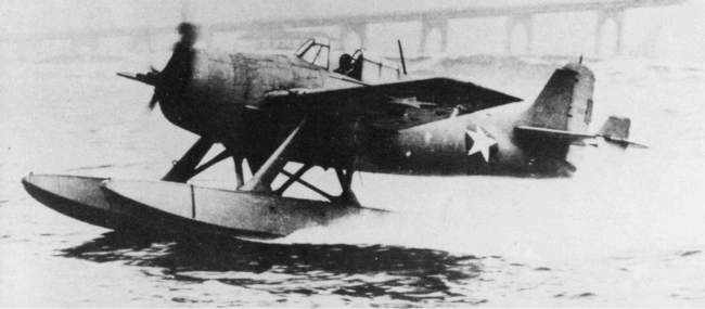
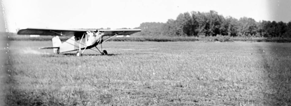
A June 1943 photo of a Grumman F4F-3S Wildcatfish – a version of the Wildcat fighter mounted on Edo floats,
which conducted rough-water landing tests from Norfolk.
A 1944 USN photo of Navy VPB-214 Martin PBM-3S Mariner, 48151 C/n 7922, on beaching gear on the Norfolk seaplane ramp.
The 1945 AAF Airfield Directory (courtesy of Scott Murdock) depicted “Norfolk NAS (Seaplane) (Breezy Point)”
as having 3 large hangars, with 4 seaplane ramps.
A 1940s National Archives photo of Martin PBM Mariners on the Norfolk seaplane ramp.
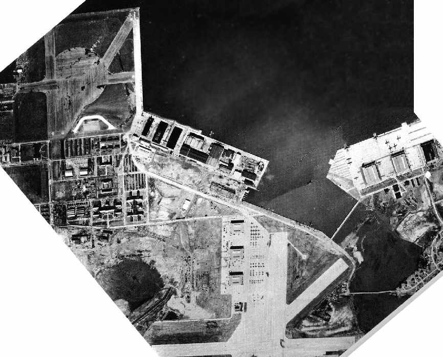
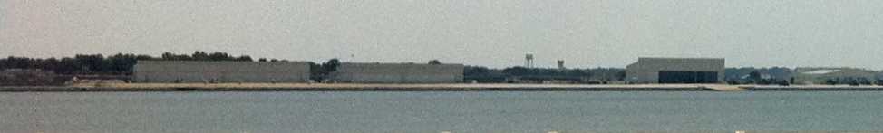
A 1940s Navy aerial photo showing Chambers Field at the top left, the new East Field at the bottom center,
and the seaplane base at the top right.
“Chambers (Navy)”, “East Field (Navy)”, and the Norfolk seaplane base were all still depicted as active
on the April 1946 Washington Sectional Chart (courtesy of Chris Kennedy).
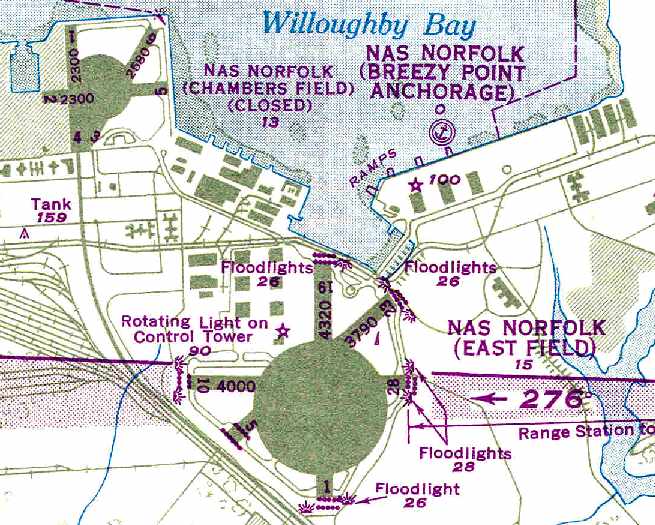
The 1950 USAF Pilot's Handbook (courtesy of Chris Kennedy)
depicted the “NAS Norfolk (Breezy Point Anchorage)” seaplane base.
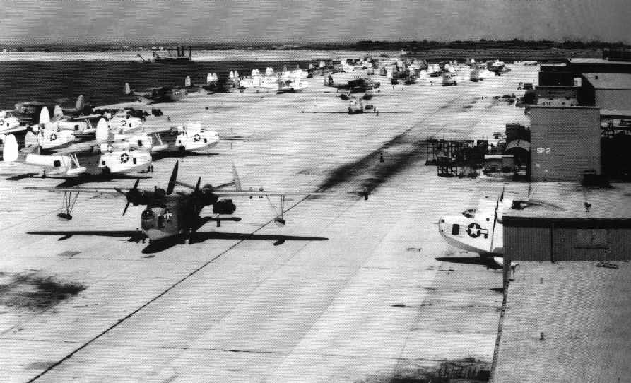
A September 1960 aerial view by Thomas McManus looking southwest at the Norfolk Breezy Point seaplane base,
with several VP-44 Martin P5M-2 flying boats (and what appears to be one R4D) on the ramp in the foreground,
and Chambers Field in the background.
Photographed from a VP-44 P5M-2 shortly after rotating.
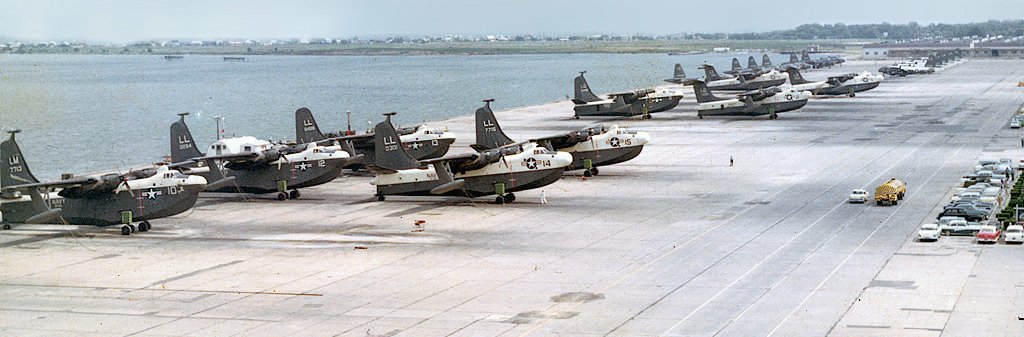
A 10/10/60 photo of Martin P5M Marlins of VP-44 & VP-56 at the Breezy Point seaplane base, with Lockheed P2V Neptunes in the background.
Norfolk Sectional Charts through 1961 (according to Chris Kennedy) still depicted the “NAS Norfolk (Breezy Point)” seaplane base.

A May 1961 photo by Thomas McManus looking north at a VP-44 Martin P5M-2 flying boat on the ramp at Breezy Point.
Note the open bomb bay doors, aft of the engine.
Thomas recalled, “This was the last P5M in service with VP-44,
as we were in the process of transitioning to the P2V-5F Neptune.
All of our P5M's had all been reassigned to NAS North Island, CA, for service with Pacific fleet squadrons.
November 1961 we deployed to Sigonella, Sicily & at the completion of our deployment in May of 1962 we returned to CONUS,
however not to Norfolk, but to NAS Patuxent River MD, where we were the first VP squadron to receive the P-3 Orion.”
Thus 1961 was the end of seaplane operations at NAS Norfolk.
However a 1963 aerial picture depicted 9 aircraft on the ramp of the seaplane base.
It was not evident whether they were seaplanes or landplanes, though.
By the time of the 1964 Norfolk Sectional Chart (according to Chris Kennedy),
the Norfolk seaplane base was no longer depicted at all.
Perry Rotzell recalled, “In 1978, there were still landing lights in Willoughby Bay.
They were mounted on pilings, in the exact same arrangement you see on an IFR field.
They were parallel to the current main runway at the naval station. The lights were gone in 1983.
I once rode me bicycle on the seaplane ramp (oh, the freedom of those long-ago days!).
I stood on one of the ramps & noticed how time and water had eroded large chunks of concrete out of seaward end.
That ramp would not hold, say, a P-5 Mariner even then.”
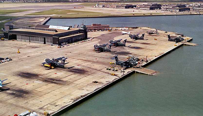
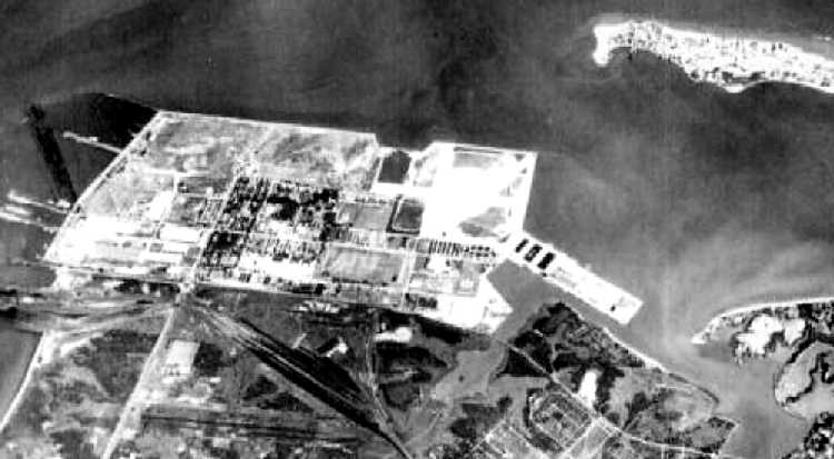
As seen in the 1990 USGS aerial photo, although seaplane operations were no longer conducted at NAS Norfolk,
the former seaplane ramp remained intact, along with the 3 former seaplane hangars.
A dozen E-2 Hawkeyes were visible parked on the ramp, along with a number of helicopters.
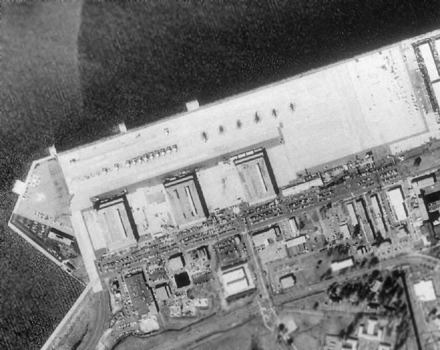
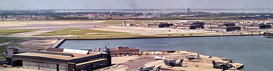
A 5/7/95 Navy aerial view by Robert Sitar, looking southeast at the old PBY/PBM seaplane ramp & hangars at the Norfolk Naval Air Station,
with several Navy MH-53E helicopters parked on the ramp.
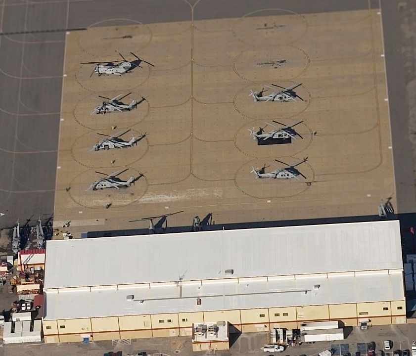
A circa 2005 aerial photo looking north at 2 MH-53E helicopters on the former NAS Norfolk seaplane apron,
with one of the former seaplane ramps leading down into the water at the top of the photo.
A 2006 photo by Scott Shea of “The Old SP-31 Hangar (the last squadron that occupied the spaces is HM-14).
They are about to demolish this hanger very very soon (maybe next week!).”
Scott Shea reported in 2006, “Hangars SP-1 & SP-2 have been completely torn down.
That was the hangars that housed the PBMs & PBYs.
SP-31 (which is one of the last of the hangars on the seaplane line) will be torn down this week.
I was stationed with HM-14, who have been in that hangar for over 10 years.
They were previously in hangar LP-14, which will be torn down as well.
Most of the original hangars on base are either being torn down or have been converted into warehouses.
The HM-14 Vanguards (an MH-53E squadron), is now in a new hangar where SP-1 & SP-2 once stood.
A lot of history went away with those hangars being torn down.”
A 2006 photo by Scott Shea of the Norfolk flightline.
Scott reported in 2006 that the location previously occupied by hangars SP-1 & SP-2 are “now occupied by 1 aircraft hangar (now building SP-36)
and next to that on the right in the photo is the new Airborne Mine Countermeasures (AMCM) Building
to house the minesweeping gear & the Seabees for HM-14.
The Hangar on the left is SP-31 that is about to be demolished. The new hangar (SP-36) is HM-14's new hangar.
They operate 12 Sikorsky MH-53E Sea Dragon Helicopters. I am a crew chief for that squadron.”
Scott Shea reported in 2006, “The seawall is now all helicopters.
There are 2 other squadrons that operate H-60s on that line as well that are obscured behind the old SP-31 hangar.
They are HSC-4 & HCS-2. HCS-2 is the Fleet replacement Aircrew and Pilot squadron for MH-60Ss.
To the end of the line is the new AIMD Norfolk building
where they rebuild electrical components & engines for the aircraft based here at Chambers.
HC-4 (also a MH-53E Squadron) for the time being is working out of MILVANS in between the 2 new buildings shown in the picture.”
Scott continued, “This new line also has 3 different helicopter pads,
the 'Dragon pad' (to the left of the MK-105 Magnetic Mine Sweeping gear that can be scene on the old seaplane ramp),
the 'Wolf Pad', and the 'Angel Pad'.
The 'Dragon pad' now has pad lights that were added in 2003, prior to that, we used to have to land at Chambers field & taxi over the taxiway
that connects the airfield to the seaplane line whenever we landed at night.
Currently that taxiway is being used as a road as the bridge that is on A street has been closed due to it being dangerous.
The Wolf & Angel pads are to the left of the picture.”
Scott continued, “The 2 new buildings that you see in the picture were built in 2005
and opened just this year (March 2006) after the old hangars were demolished in 2004.
The new hangar for the MH-53E is only large enough to accommodate maybe 3 (definitely 2) spread MH-53E inside the hangar.
The rotor arc is 79' long, so add maybe 20' to either side of that & that's how large the hangar is.
We could put 4 spread MH-53E in the old SP-31 hangar.
The old SP-31 hangar also has some sort of elevator, presumably for loading ordinance to the old PBMs & PBYs.”
Scott continued, “Right now SP-31 & the small COMHELTACWING building at the end to the right
are all that is left standing of the old seaplane base.
The buildings behind the seaplane line areas are still there, including barracks & schoolhouses.
The old seaplane ramps are still somewhat used today.
One shown in the picture is used for our 'Sled Ops', when we use the Mk.105 minesweeping gear.
This one is located near the 'Dragon Pad',
the boat crews use another ramp to launch the boats for the Sled Ops.
Both of the ramps do not look in great condition
and they definitely couldn't support the weight of much more than a truck & a boat on a trailer.”
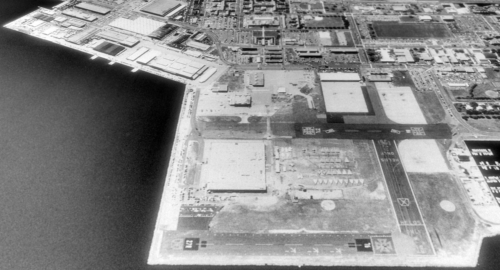
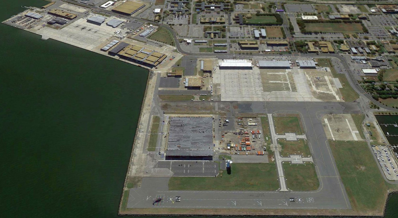
A July 2011 photo by Paul Freeman looking south along the former Norfolk seaplane flightline.
The site of the Norfolk Seaplane Base is located northwest of the intersection of 5th Street & A Street.
____________________________________________________
(Original) Naval Air Station Norfolk / Chambers Field, Norfolk, VA
36.953, -76.303 (Northwest of Norfolk, VA)
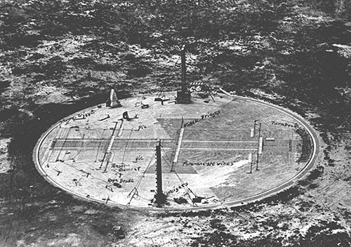
A undated early aerial photo of the arresting gear test site used at NAS Hampton Roads starting in 1921 (courtesy of Andrew Payne).
The use of this site in Norfolk for aviation dates back to 1917,
when the “Naval Air Detachment, Naval Operating Base, Hampton Roads” was established.
Initial operations here involved seaplanes.
The date of construction of the Chambers Field landplane airfield has not been determined.
NAS Norfolk was credited with developing an arresting device
to train pilots for deck landings aboard the fleet's first aircraft carrier, USS Langley (CV-1).
At the same time, the station also began work on the development of the catapult.
According to Naval Aviation News (courtesy of Andrew Payne),
“On 8/11/1921, the practical development of carrier arresting gear began at NAS Hampton Roads,
when Lt. Alfred Pride taxied an Aeromarine onto a dummy deck aboard the station & engaged its arresting wires.”
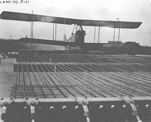
An undated photo of an Aeromarine sitting on a dummy carrier deck at NAS Hampton Roads during testing which started in 1921 (courtesy of Andrew Payne),
with fore & aft wires in front of the aircraft to keep it on a straight path during its landing.
In January 1923, the Secretary of the Navy ordered a detailed study
of the capacity of the bases & stations during war & peace.
In comparing the development of the fleet & shore establishments, only Hampton Roads met the requirements.
Lighter-than-air operations, important for off-shore patrols during the war, ceased in 1924.
A May 1924 USN aerial view looking southeast (courtesy of Pam Thomas) depicted Chambers Field as a rectangular grass field, on which was a circular blimp mooring circle.
A row of seaplane hangars extended to the east, and a large dirigible hangar was on the opposite side of a row of buildings along the south side of the airfield.
In an effort similar to base closure struggles the military has today,
civilian employees of the Assembly & Repair Department (forerunner of the former Naval Air Depot)
joined the Norfolk Chamber of Commerce in successfully fighting the planned suspension of aircraft overhaul work.
The training of air groups from newly-commissioned aircraft carriers such as Langley, USS Saratoga, and USS Lexington
demanded expansion, but appropriations were meager for shore establishments.
The test arresting gear wires & their associated equipment were removed from NAS Hampton Roads beginning in 1929.
The earliest aeronautical chart depiction which has been located of the Norfolk Navy airfield
was on the 1932 Washington-Hampton Air Navigation Map #4.
The Airport Directory Company's 1933 Airport Directory (courtesy of Chris Kennedy)
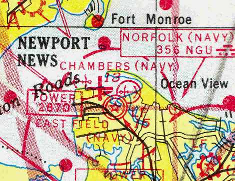
described the Norfolk Naval Air Station as being located as the east end of the Naval Operating Base, opposite Fort Monroe.
It was said to consist of a 103-acre rectangular sod field, measuring 2,500' x 2,200', with a single 2,000' cinder runway.
A hangar was said to be marked with “USN Norfolk”.
The expansion of shipboard aviation in the 1930s brought renewed emphasis to Naval Air Station Norfolk.
Reverting back to its experimental roots, development & testing of catapult & arresting gear systems took the highest priority at the Air Station.
The commissioning of the aircraft carriers Wasp, Ranger, Yorktown and Hornet
increased the tempo of routine training in navigation, gunnery, and aerial bombing as new air wings formed prior to World War II.
This demanded expansion, but appropriations for shore activities were meager.
Although congressional approval was gained in 1934 for the purchase of land
that would expand the airfield by 540 acres, the matter was dropped.
A 1935 Navy Aviation Chart (courtesy of Chris Kennedy) depicted Chambers Field as a “Landing Field”,
with the buildings to the southeast being labeled “Naval Air Station”.
An aerial view looking southeast at the “Hampton Roads Naval Air Station”=from a 1935 Navy Aviation Chart (courtesy of Chris Kennedy).
It described the field as having a 2,500' x 2,200' sand loam field & a hangar marked with “U.S.N. Norfolk”.
The 1935 Air Pilots Register (courtesy of Paul McMillan) depicted the Norfolk Naval Air Station
as being a 2,500' x 2,400' sod field having a 2,000' cinder northwest/southeast runway on the east side,
and a much shorter northeast/southwest “Landing Platform” in the center.
The 1/1/36 Commerce Department Airway Bulletin described NAS Norfolk as a nearly square sod field, measuring 2,500' x 2,400'.
It was said to have one 2,200' cinder runway.
A circa 1938-39 aerial view looking north showed the original Chambers Field,
shortly before the addition of the new East Field or the Seaplane Base.
At the outbreak of war in Europe on 9/1/39,
Naval Air Station encompassed 236 acres with 2 small operating areas: Chambers Field & West Landing Field.
The West Landing Field was west of the former exposition boat basin, and was occasionally used for aircraft operations.
The July 1941 Norfolk Sectional Chart (courtesy of Chris Kennedy) depicted Chambers Field, as well as the adjacent seaplane base.
In 1941, the possibility of U.S. involvement in the war looked more likely.
Construction of more new facilities was pushed forward to match increased requirements.
Directives from Washington meant facilities had to be developed to operate 5 aircraft carrier air groups,
7-9 patrol squadrons, the fighter director school,
and the Atlantic Fleet operational training program for 200 pilots prior to their fleet assignment.
Further requests were made to provide training & maintenance facilities
for British aircrew from HMS Illustrious & HMS Formidable.
In all, these new requirements led to enlarging the construction project to 5 times its original scope.
At the completion of the first round of construction, East Field was estimated to have the capacity for 410 land planes
while Breezy Point's capacity was estimated at 72 seaplanes.
An 11/7/41 Navy aerial photo showing Chambers Field at the top left, the new East Field at the bottom center,
and the seaplane base at the top right.
The original Chambers Field was closed to transient aircraft during WW2.
Aircraft could taxi from Chambers under their own power directly to carrier piers, to be hoisted aboard ship.
“Chambers (Navy)”, “East Field (Navy)”, and the Norfolk seaplane base were all still depicted as active
on the April 1946 Washington Sectional Chart (courtesy of Chris Kennedy).
The original Chambers Field was evidently closed at some point between 1946-50,
as it was depicted as “NAS Norfolk (Chambers Field) (Closed)” on the 1950 USAF Pilot's Handbook (courtesy of Chris Kennedy).
It depicted the field as having 3 paved runways (with the longest being a 2,580' northeast/southwest strip),
with a large circular paved area in the center.
A September 1960 aerial view by Thomas McManus looking southwest at Chambers Field,
with the Breezy Point seaplane base in the foreground.
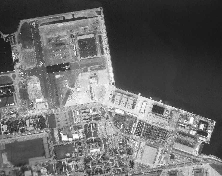
A 1963 aerial photo showed a foreshortened set of runways (18/36 & 9/27), perhaps intended only for helicopter operations.
A large number of aircraft of various types were visible on the east side of the field.
A January 1978 DOD aerial photo of the original Chambers Field, showing several remaining runway segments.
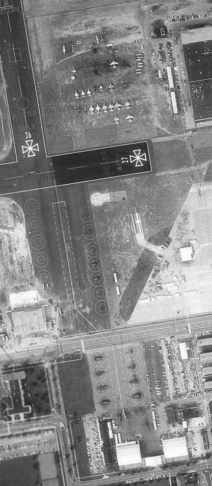
A closeup from the January 1978 DOD aerial photo showing a large number of aircraft (A-6s, A-7s, helicopters, etc.) on the original Chambers Field.
Perry Rotzell recalled, “The large building across one of the old runways at the former Chambers field was the Naval Air Depot.
I had some electronics-related training there in 1980.
They rebuilt F-14s & A-6s in those days. There were some heavily damaged F-14's stored there.
Some were obviously striped of parts, while others had torn-off wings & what-not.
And it was exciting to stand in the parking lot and watch H-46's do touch & go's.
They flew about 30' above your car.”
Perry Rotzell continued, “The NAD closed in the mid-1990's.
At that time, the P-2 Neptune patrol bomber, 'Truculent Turtle',
famous for an unrefueled non-stop flight from Australia to Ohio, was stored near the NAD.
I was able to climb into the gutted cockpit & check it out.”
Perry Rotzell continued, “There was a 250' tall communications tower adjacent to the west end of the right hand helicopter runway.
There were some weird looking covers over some of the protruding antennas.
One cover, which looked just like 2 aluminum bowls joined together, had a huge dent in it.
A friend told me a helicopter had damaged the bowl with its rotors.”
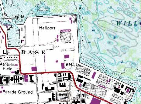
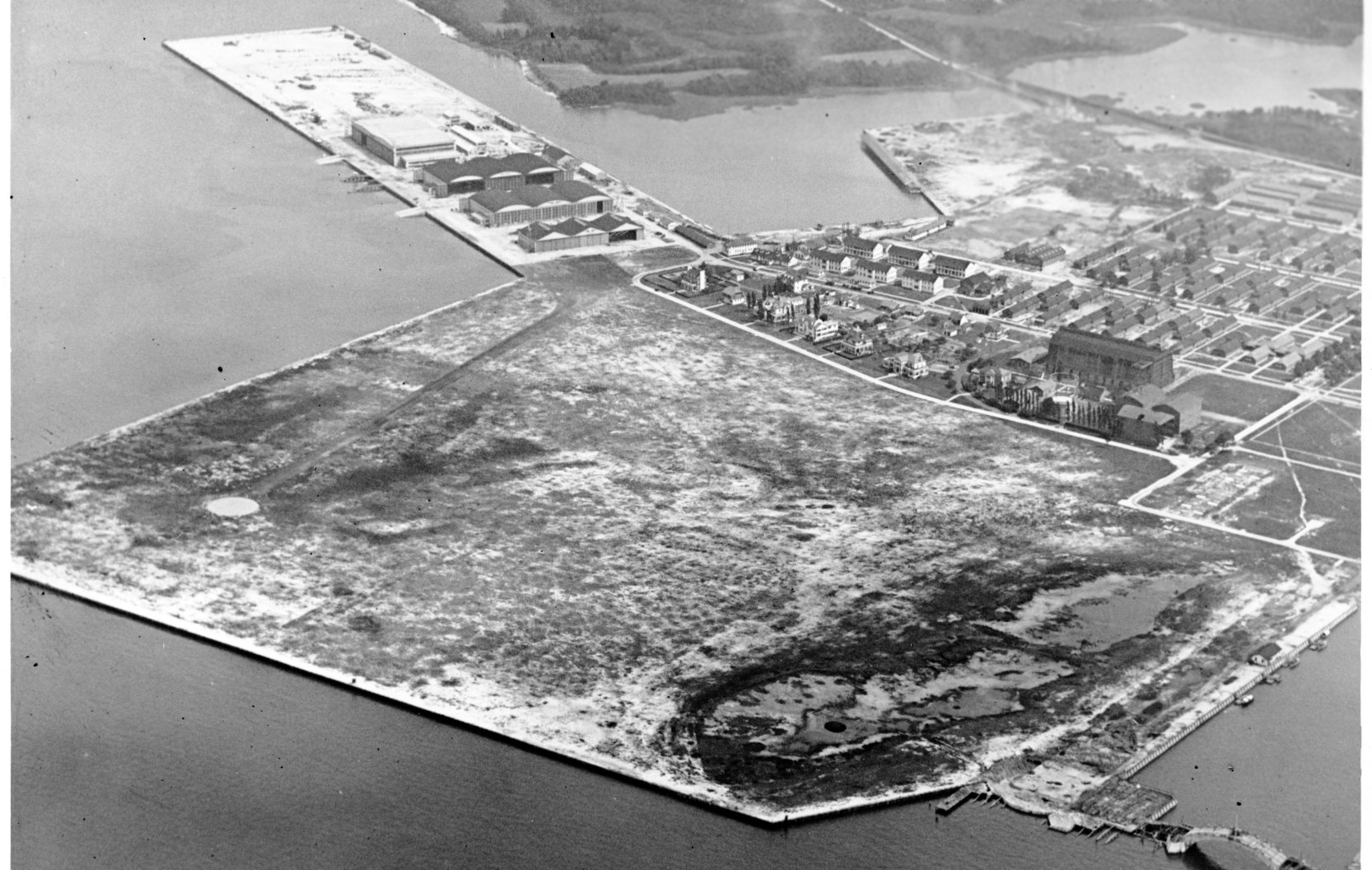
Two of the original Chambers Field former runways were still depicted on the 1989 USGS topo map, which labeled the site as a “Heliport”.
A large building had been built over the northeast side of the site.
A 1990 USGS aerial view looking south showed 2 former runways of the original Chambers Field still remained intact, but were marked for “Helos only”.
Over a dozen helicopters were visible parked on ramps on the southwest side of the field,
and a ramp to the northeast held a dozen F-14 Tomcat fighters, as well as other smaller jet aircraft.
A circa 2005 aerial photo looking north at a collection of aircraft at the center of Chambers Field which presumably have been grounded,
including an F/A-18, 2 E-2s, and 2 F-14s.
A circa 2005 aerial photo looking north at a hangar along the southern edge of Chambers Field with a CH-46 & several MH-60s.
A 2016 aerial view looking south showed 2 former runways of the original Chambers Field still remained intact, still used for helicopters.
The site of the original Chambers Field is located northwest of the intersection of Hornet Street & Avionics Loop.
____________________________________________________
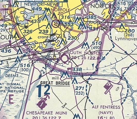
36.61, -76.39 (South of Norfolk, VA)
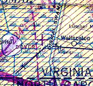
Dover Airport, as depicted on the September 1943 Norfolk Sectional Chart (courtesy of Chris Kennedy).
Photo of airport while in use has not been located.
According to Jamie Smith (who heard about it from a farmer), this airfield was "built in 1938 (or thereabouts)."
Dover Airport was not yet listed among active airports in The Airport Directory Company's 1937 Airport Directory (courtesy of Bob Rambo),
and no airfield was depicted at this location on the March 1943 Norfolk Sectional Chart.
The earliest depiction of this airfield which has been located was on the September 1943 Norfolk Sectional Chart (courtesy of Chris Kennedy).
It depicted Dover as an auxiliary airfield.
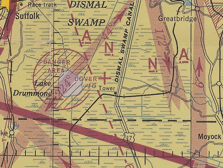
According to Rodney Johnson, “There were about 4 Quonset hut at Dover Field.
Lake Drummond was used as a practice bombing range. The field was used to fly in the buoys which outlined a ship in the lake.
The huts were used to assemble the buoys. The buoys were put in the lake by boat.
There was a big path from the back of Dover Field to the lake - it was called Soldiers Path.
Buck McCoy’s cabin was used as the call station for the 'raids'.
Planes that were not on the strike would sit on the ground at Dover or Fentress.”
The last aeronautical chart depiction which has been located of the Dover Airfield was on the September 1944 Norfolk Sectional Chart (courtesy of Ron Plante).
It depicted Dover as an auxiliary airfield.
The Dover Airport was presumably closed at some point between 1944-45,
as it was no longer depicted at all on the April 1945 Norfolk Sectional Chart or the 1945 USGS topo map.
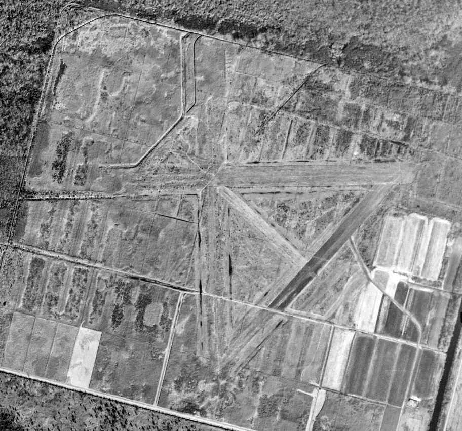
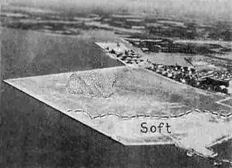
The earliest photo which has been located of Dover Airport was a 1/30/53 USGS aerial view, which depicted at least 3 unpaved runways. No buildings were depicted at the site.
According to Rodney Johnson, “The buoys were removed from the lake in the 1960s using radar magnets with floats.
Many of the buoys were shot up with machine guns.
There is probably still communication cable in the trees.
Our family had 3 cabins in the swamp with over the 100 plus years in the swamp.
My Dad was the one who had to find the buoys in the lake. He found all but two.
I remember playing in the air field in the early 1960s.
We had a camp where we kept the hunting dogs & our jeeps at the old CCC camp on the northwest corner of the feeder ditch & GW canal.
My family tried to buy the airfield which was then a farm.
My funniest remembrances were using M-80 firecrackers to detonate the smoke bombs
that the planes would drop – you could find them at low water,
and getting the hell shocked out of me wile playing with a magneto which I found in the airfield huts.
The big fire in the mid 1960s wiped out the huts & the CCC camp.”
No airfield was depicted at this location on the 1969 or 1982 USGS topo maps.
Amazingly, the 1989 USGS topo map still depicted a very detailed runway layout of Dover Airport,
depicting at least 3 unpaved runways (with a 4,000' east/west strip being the longest runway).
No buildings were depicted at the site, which was also unlabeled.
Jamie Smith reported in 2004, "It's a soybean or potato farm now, but you can still make out the runway tracks."
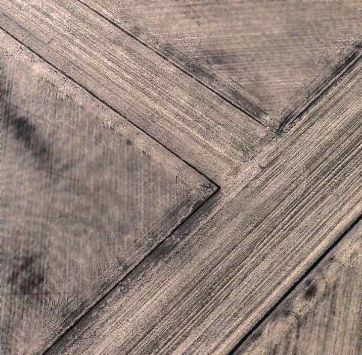
A circa 2005 aerial photo looking north at a former runway intersection at Dover Airport,
showing that the former runways remain quite recognizable.
Kelsey Gray reported, “Dover Airport... the site was in agricultural production until 2009,
at which point it was put into a Conservation Easement (held by TNC) and the wetlands on the property were restored.”
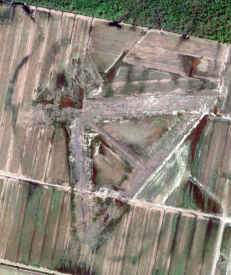
After more than 70 years since the Dover Airport was constructed, a 4/6/10 aerial photo (courtesy of Les Parker) still showed a very distinct runway layout.
Kelsey Gray reported in 2020, “ It is now maintained as a Wetland Mitigation Bank & some folks use it for hunting as well.
The project aims to offset impacts to wetlands within the watershed in accordance with the Clean Water Act.
Our company currently owns the property & we have the pleasure of occasionally encountering old bunkers while we’re out doing our vegetation or hydrologic monitoring.”
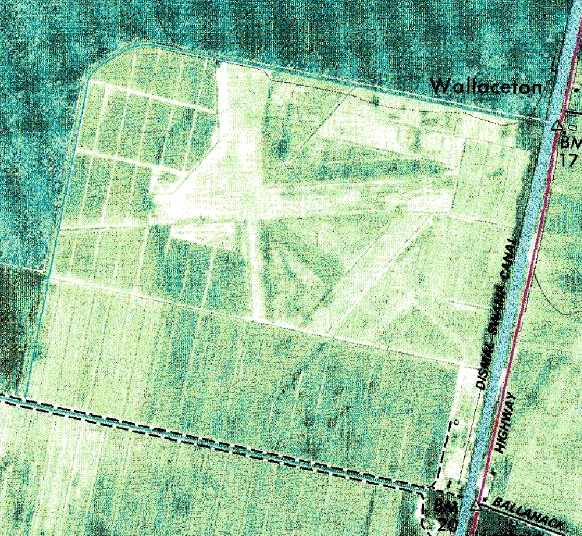
The site of Dover Airport is located northwest of the intersection of Route 17 & Ballahack Road.
The airfield is bounded by the Intercoastal Waterway (the Dismal Swamp Canal) on the east, and by the Great Dismal Swamp on the west.
Thanks to Jamie Smith for pointing out this field.
____________________________________________________
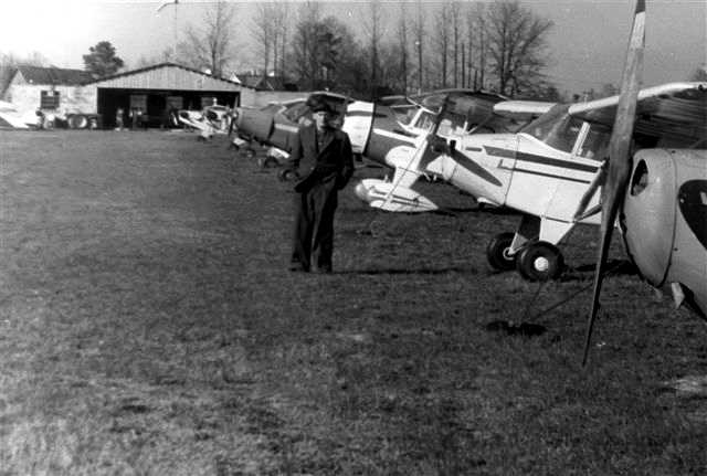
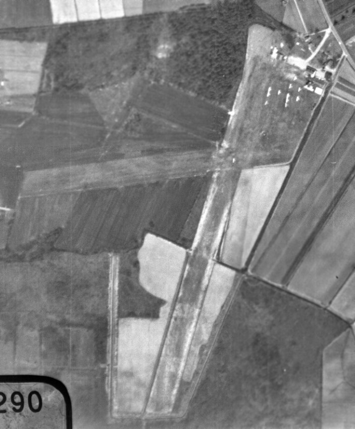
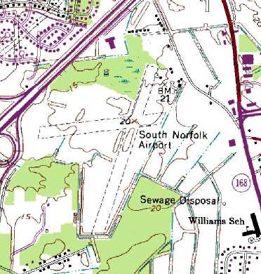
South Norfolk Airport (W33), Chesapeake, VA
36.764, -76.258 (South of Norfolk, VA)
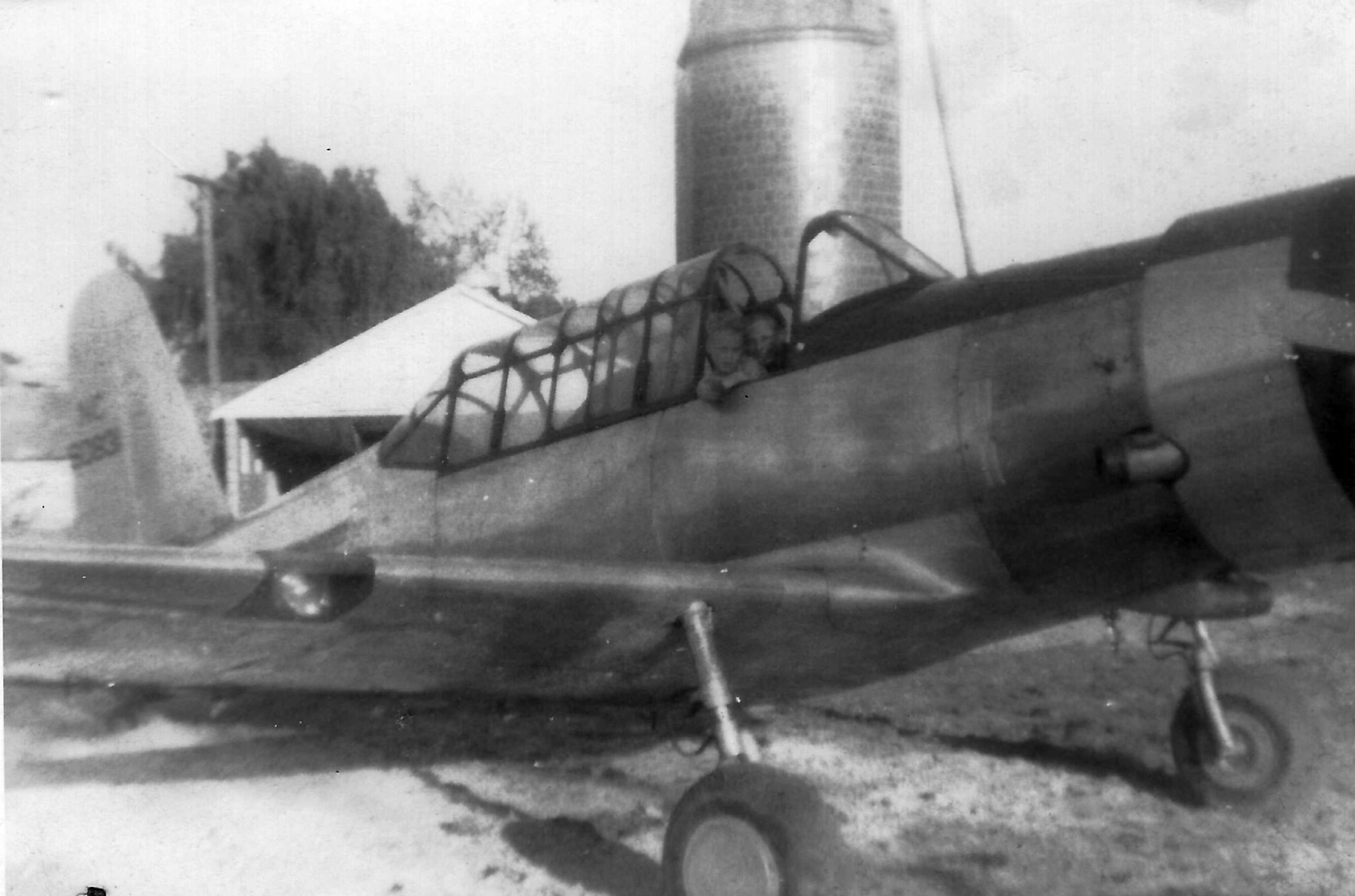
A 1946-48 photo (courtesy of Richele Todd) of Richard Todd & another person inside a Vultee BT-13 at South Norfolk Airport.
South Norfolk Airport was not yet depicted on the October 1946 Norfolk Sectional Chart.
South Norfolk Airport was opened in 1946 by the Todd family,
according to an article by Norm Crabill in the 10/04 issue of the VAHS Virginia Eagles.
Richele Told reported, “My great grandfather was Richard D Todd. My father was named after him, Richard D Todd II.
The farm was established by my great grandfather & his wife then, passed down to my grandparents, and eventually father, and aunt were added to the deed.”
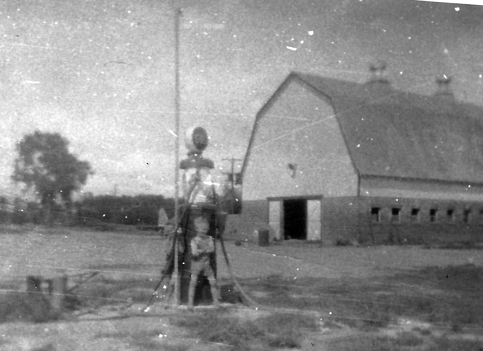
A 1946-48 photo by Richard Todd (courtesy of Richele Todd) of Bobby Todd in front of the South Norfolk Airport fuel pump, with the word “Airport” visible on the barn roof in the background.
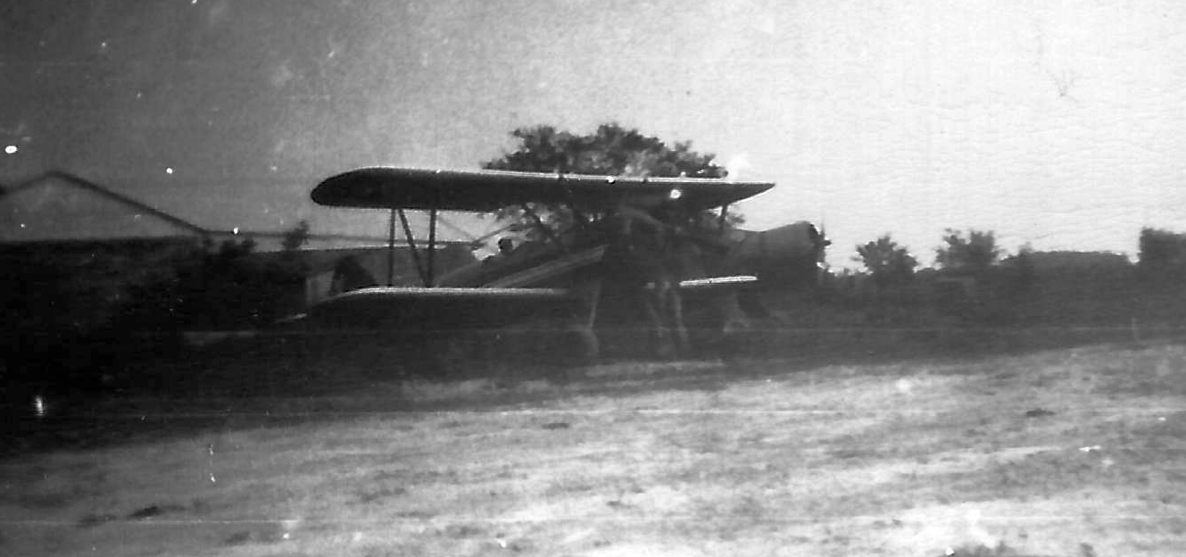
A 1946-48 photo by Richard Todd (courtesy of Richele Todd) of an unidentified biplane & monoplane at South Norfolk Airport.
The earliest aeronautical chart depiction of South Norfolk Airport which has been located was on the April 1947 Norfolk Sectional Chart.
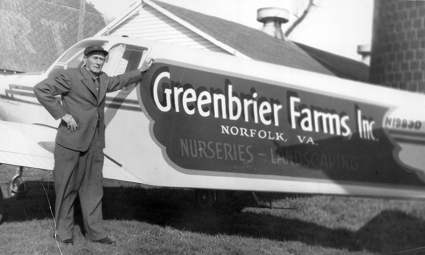
A circa late 1940s photo of Richard Todd (Richele Todd's great grandfather) standing by the Greenbrier Farms Beech Bonanza in front of the South Norfolk Airport barn.
A circa 1940s-50s view of Richard Todd & a line of taildraggers at South Norfolk Airport.
The earliest aerial photo which has been located of South Norfolk Airport was a 1948 aerial view by Susan Guagliumi, which depicted an unpaved runway.
Jeanne Powell Jordano recalled of South Norfolk Airport, “My father, Louis P Powell was a flight instructor there.
My father's era was late 1940s - early 1950s. Greenbrier Farms / Nursery kept their charter planes there.
I was an only child & my father took me to the Airport & up in the planes all the time.”
A 2/8/51 USGS aerial view depicted South Norfolk Airport as having 2 unpaved runways, with several small buildings & a few light aircraft on the northeast side.
A circa 1951-54 photo of 12-14 year old Richard Todd (Richele Todd's father), with the barn marked “S Norfolk Airport” in the background.
The Todd family continued to operate South Norfolk Airport until 1954-55, when Don Wilson took it over.
Richele Todd clarified, “Don Wilson rented the facility & operated it. My father's [Richard Todd's] family owned the property & facilities.”
The 1955 USGS topo map depicted South Norfolk Airport as having 2 unpaved runways, with several small buildings on the northeast side.
The 1957 Norfolk Sectional Chart depicted South Norfolk Airport as having a 2,500' unpaved runway.
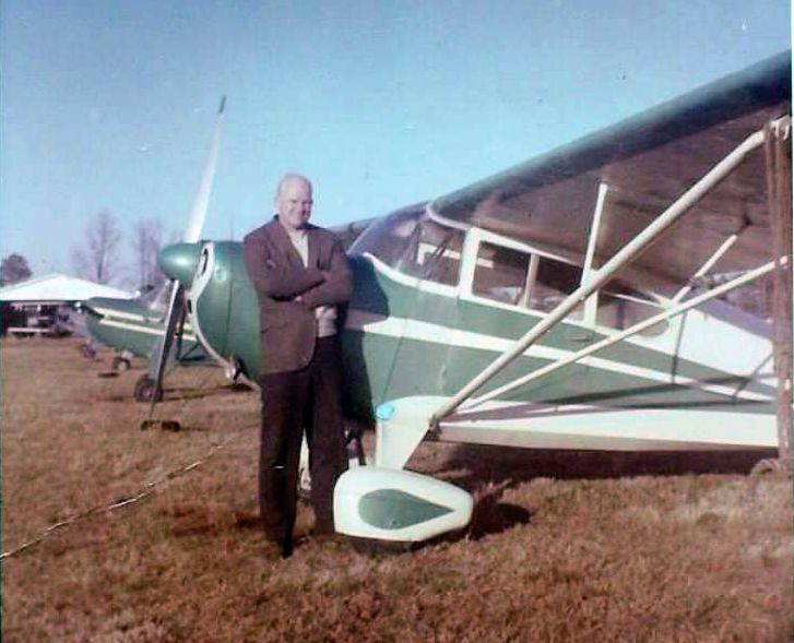
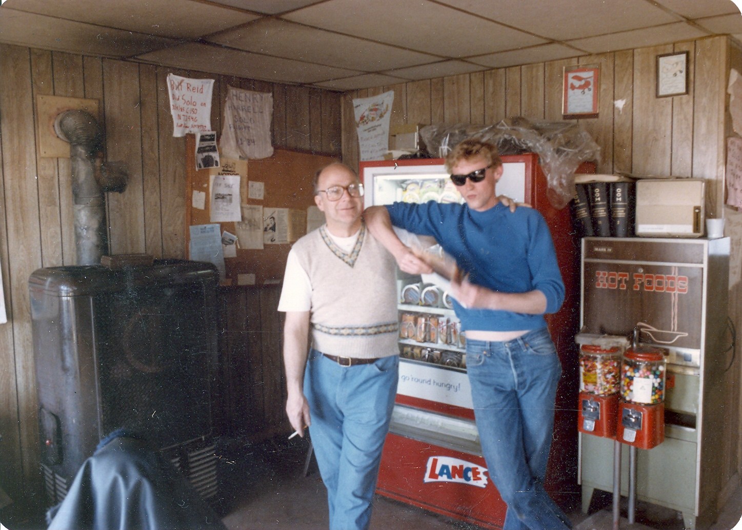
A circa early 1960s photo of Bill Morgan (“I'm the one with no hair”) & Don Wilson (kneeling) in front of a 1933 Waco that they had just rebuilt at South Norfolk Airport.
Bill Morgan recalled, “South Norfolk Airport... I started my aviation career there in the late 1950s & I also slept in the bunk room in the back of the office.
When I arrived to learn to fly the [operator] Don Wilson & his partner, Carol Newton, were breaking up.
In the break-up deal she was taking an airplane they had just rebuilt, a Funk with it's name on the door, ('Funk Yew Too').
So my flying lessons began with all the color that, Don, Mr. Wilson could produce.
We became good friends & spent every moment that I could at South Norfolk & eventfully went to work there.
Don was a pioneer of aviation. He believed everyone should learn to fly & thank God I was included in that because I was always short on cash.
The rates for renting a J-3 Cub were $7 solo & with an instructor $10/hour. He paid the instructors $4/hour.
Yes, he subsidized the instructors. He paid on the honor system. His rules were no rules.”
Bill continued, “When I started I had been observing a lot of the students doing mild aerobatics so on my 3rd flight lesson I asked Don, 'How do you loop the airplane?'
The next thing I knew he was lining up on the runway at about 1,500' & up & around we went.
We leveled off & he said, 'Your turn!'
I don't remember what that lesson was all about but I could loop the hell out of a J-3 Cub before it was over.
I loved the grassroots flying & spent time at South Norfolk until it closed. I felt like I owned an airline after I based my Cessna 172 there.”
A circa early 1960s photo by Bill Morgan of a Piper PA-15 at South Norfolk Airport.
A circa early 1960s photo of Bill Morgan's 1946 Aeronca 11-AC that he purchased “one Christmas Eve on the field for $750” at South Norfolk Airport.
The 1961 Norfolk Sectional Chart (according to Chris Kennedy)
described South Norfolk as having 2 turf runways, with the longest being 3,250'.
A 3/30/63 aerial photo depicted South Norfolk as having 2 grass runways, with a dozen light aircraft parked on the northeast side.
A circa 1960s aerial picture of a large number of planes tied-down at South Norfolk Airport.
Bill recalled, “In 1965 Don bought a brand new Piper Cherokee 180 & was spoiling to take it for a real trip.
He asked me if I wanted to go on a little cross-country to his family's ranch in Jordan MT where landed in a alfalfa field which was over 5,000' high.
That was my lesson on density altitude & during the next 2 weeks I spent one of the most wonderful times of my life.
We flew around the Devils Tower & Mount Rushmore at treetop level (you would be shot down now).
When we came back to South Norfolk I quit my job & made up my mind I was going to fly for money
so Don put me to work roofing the hangar & cleaning the cow pies off the airplanes (South Norfolk was also a dairy farm).
Don also put me to work rebuilding J-3 Cub engines & airframes & soon as I got my Certified Flight Instructor, instructing.
In less than a year I was hired by Piedmont Aviation (owner of Piedmont Airlines) as a flight instructor & the year after that I moved over to the airline as a pilot.
Thanks to Don, the airline & others I didn't spend more than $500 on all my training (would never happen today).
The next 30 years I flew taildraggers, turboprops, business jets & Boeing's finest.
I retired after flying 737s, 727s, 757s & 767ERs to Europe & South & Central America.
Thanks to South Norfolk Airport it was a hell of a ride.”
The March 1965 Norfolk Local Aeronautical Chart (courtesy of John Ferrara) depicted South Norfolk Airport as having a 3,200' unpaved runway.
The Tidewater Soaring Society began flying out of South Norfolk Airport in 1966, before eventually relocating to Garner.
Duncan Richardson recalled, “In May 1970 with plenty of hours but short on funds I was working my way towards a basic Commercial Pilots License planing to train as a crop duster.
A duster friend of mine had instructed at South Norfolk & suggested I go there to get my required hours of flight instruction.
I contacted Don Wilson, a wonderful kind man, who let me stay in a bunk room behind the office at South Norfolk for a month.
He would often invite me to his home for a meal too.
There was great camaraderie there, lots of Navy folk, and a cigar-chomping mechanic rebuilding a J3 Cub.
I recall Lee Dee & his wife, he a pilot with Overseas National who had rebuilt a BT-13 he kept at the field & taught his wife to fly on it.
Don owned a Cherokee 140 for instruction & a couple of Cubs on which I logged taildragger time.
My Instrument time included a night flight with Earl Faircloth who was just out of the Army, down to Fort Bragg where I was given a radar guided approach by the controllers.
Sad to see South Norfolk has long gone.
The best instruction a young pilot could get was hangar talk from the old timers & flying planes that could bite you if you were not careful.”
The 1970 VA Airport Directory (courtesy of Stephen Mahaley)
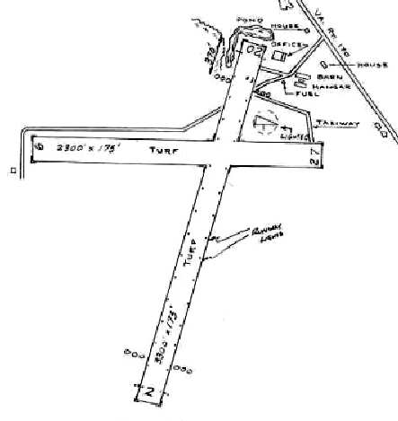
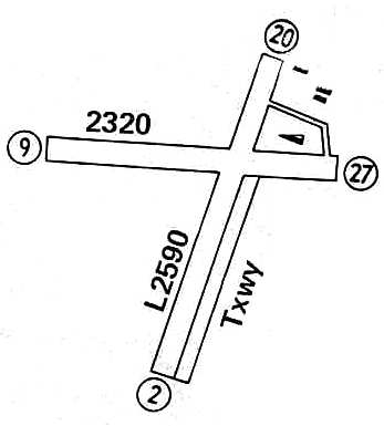
described South Norfolk Airport as having 2 turf runways: 3,300; Runway 2/20 & 2,300; Runway 9/27.
An office, hangar, and barn were depicted northeast of the runway intersection.
The airport was said to offer flight instruction (including glider instruction), and charter.
The operator was listed as South Norfolk Air Service, and the manager was listed as D. R. Wilson.
Starting in 1971-72, South Norfolk was jointly operated by Don Wilson & Alston "Steve" Stevens.
Stevens later took over the operation of the airport, and continued to run it for the rest of its life.
From the early 1970s onward, South Norfolk Airport operated under a continual threat of impending closure.
A June 1973 photo of a Piper PA-28-140 Cherokee at South Norfolk Airport.
The March 1974 Washington Sectional Chart (courtesy of Jonathan Westerling) depicted South Norfolk Airport as having a 3,200' unpaved runway.
Bruce Forr recalled, “I learned how to fly at W33 in 1974 while I was still in the Navy.
I had been persuaded by a buddy of mine, Shannon Ennis, who went on to fly for U.S. Air, to give it a try.
My first airplane ride was with R. Forsythe (CFI) and I soloed under my 1st instructor, L.H. Tarkington.
I finished up my Private License with Paul Carr, a wet-behind-the-ears 18 year-old instructor, whose CFI still had wet ink on it when he took me on.
If my records can be believed, it cost me about $600 from start to completion of my Private License.
I remember a cigar chomping mechanic that ran the flight school.”
Dave Moniot recalled, “I learned to fly out of South Norfolk Airport in 1976 & knew Guy Stevens (Ray's brother).
It was indeed 'The greatest airport in the world'.
You could rent a Cessna 150 for $13 / hour, get a drink out of the old coke machine
and just pay for your time with the honor system by leaving money in an old desk drawer.”
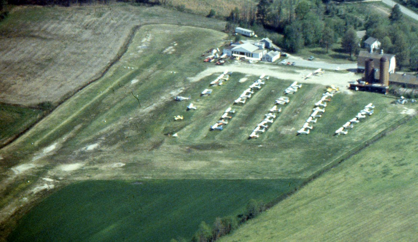
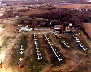
A 1977 aerial view by Robert Powell looking north at a very popular South Norfolk Airport, with many light aircraft parked on the north end of the field.
Robert Powell recalled, “I bought my first airplane there, a 1946 Luscombe.”
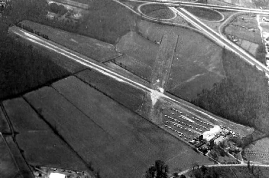
A 3/18/78 aerial view by Kenneth Keeton looking southwest at South Norfolk Airport, with over 40 light aircraft visible on the field.
Dave Young remarked, “I recalled my early flying lessons at the South Norfolk Airport... ol' Whiskey-33.
How I dearly remember every blade of dew-soaked grass on an early-morning pre-flight
before my wonderful instructor Gerry Putnam showed up (former USAF B-52 driver; Ger was also a fellow SCUBA instructor at the time);
how I recall kicking the squadrons of rabbits up from underfoot just walking to the office to grab an honor-system clipboard with the keys...
rows of C-150's going for $22 / hour; and the thrill of the O-200 coughing to life in the dead stillness of a misty summer morn.
Mostly; I remember Ger's infinite patience with this landlubber learning the secret ways of the atmosphere.
Good bless the wanna-be aviation chile nowadays who still gets to experience anything remotely like that sense of excitement and freedom.
(as opposed to the sterile, codified, rectified, certified, bonified experience they -mostly- dispense at FBOs in 2009).”
South Norfolk Airport, as depicted in the 1979 Flight Guide (courtesy of Chris Kennedy).
The last aeronautical chart depiction which has been located of South Norfolk Airport was on the March 1981 Norfolk Sectional Chart.
It depicted South Norfolk Airport as having a 2,600' unpaved runway.
Bill Stanton recalled, “I began my flight training at South Norfolk Airport (W33) on 12/2/81. My instructor was Mike Williams.
I soloed on 1/26/83, at South Norfolk after about 30 hours of instruction.
When I soloed at South Norfolk they cut out my shirtail & framed it & had it on display there.”
The 1982 AOPA Airport Directory (courtesy of Ed Drury) described South Norfolk Airport as having 2 turf runways,
with the longest being the 3,300' Runway 2/20.
The operator was listed as South Norfolk Air Service.
A 1982 photo of Carol Clements at South Norfolk Airport (courtesy of Jim Jarvis).
Jim recalled, “Mr. Clements was my 1st flight instructor.”
At its peak, South Norfolk Airport had 60 general aviation aircraft based on the field.
A main hangar held 3 aircraft, along with a cow barn used as a hangar to hold 4 Citabirias, and 2 other private hangars.
A stolen C-90 King Air was once dumped at South Norfolk, after delivering a load of drugs elsewhere.
South Norfolk hosted flight instruction, sales, service, crop dustings, banner towing, and glider flights.
Air shows were occasionally held, usually sponsored by the HRA Club & the Portsmouth Flyers.
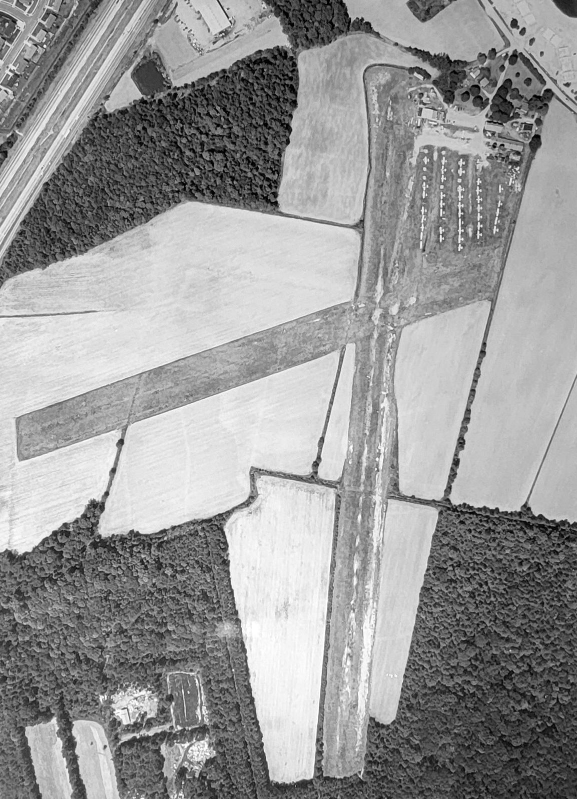
A circa early 180s aerial view (courtesy of Richele Todd) showed South Norfolk Airport at perhaps the zenith of its popularity, with over 40 light aircraft seen on the field.
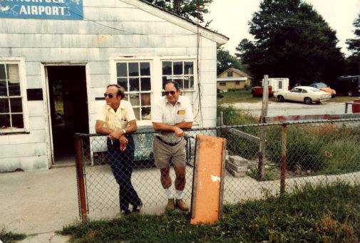
A circa 1983 photo of Richard Todd (Richele Todd's father) & Jim Stevens inside the South Norfolk Airport office.
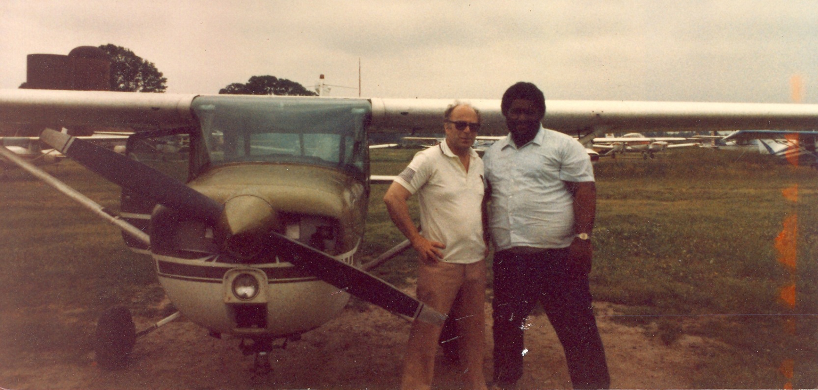
A circa early 1980s photo at South Norfolk Airport, which Richele Todd noted was of “Richard Todd (my father) & another South Norfolk pilot who worked at NorShipCo.
They flew together frequently & received their pilot licenses around the same time.”
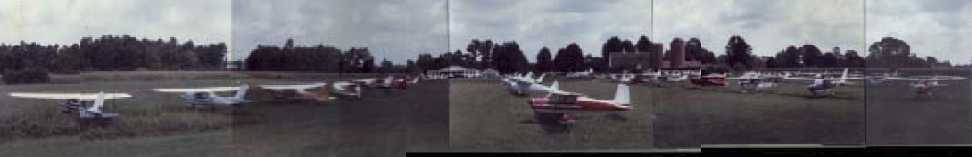
A July 1985 panoramic picture of some of the 60 planes based at South Norfolk Airport.
Ray Stevens reported in 2003, of South Norfolk Airport, "My dad & my brothers ran it until it closed in 1985.
It was the greatest airport in the world."
South Norfolk Airport was closed on 11/5/85, according to an article by Norm Crabill in the 10/04 issue of the VAHS Virginia Eagles.
The property had fallen victim to rising land values, and was redeveloped.
South Norfolk Airport was still depicted on the 1986 USGS topo map, even though it had been closed the year before.
South Norfolk Airport was no longer depicted on the March 1987 Norfolk Sectional Chart.
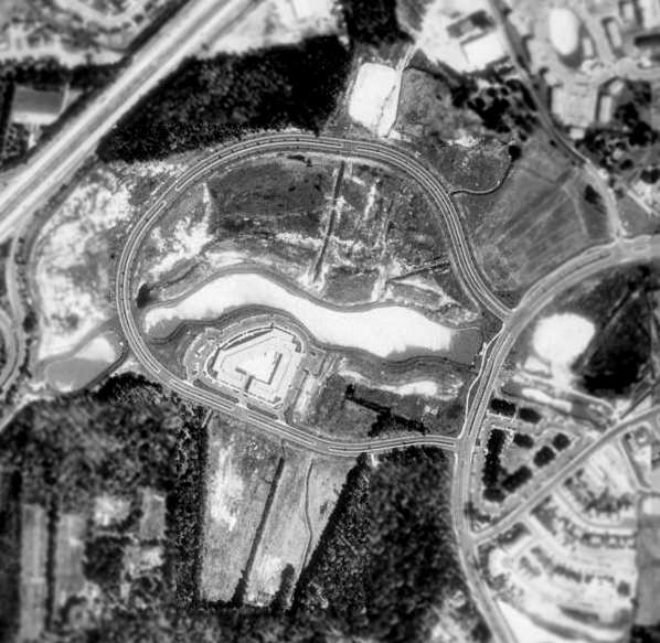
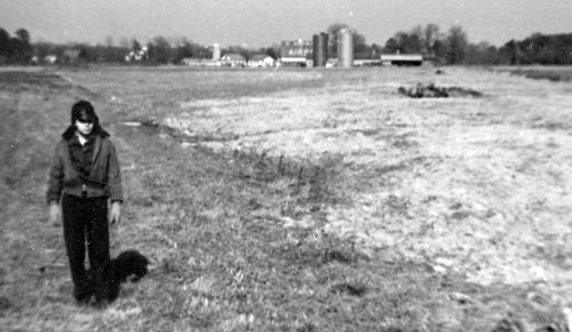
A 1994 USGS aerial view of the site of South Norfolk Airport showed the southern portion of the former north/south runway was still recognizable.
However, a new road (Independence Parkway) had been built in a loop over most of the former airport property.
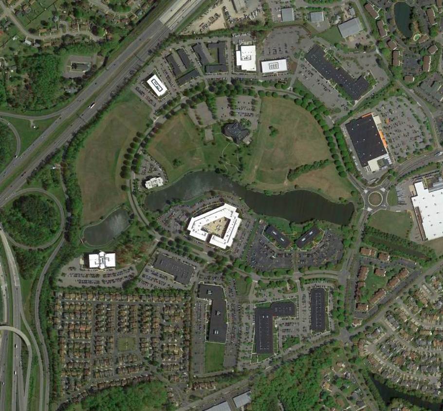
A 2014 aerial photo showed no recognizable trace remaining of South Norfolk Airport.
Richele Todd reported in 2021 of South Norfolk Airport, “The only thing left of the original property is 5 or 6 pine trees my grandmother & I planted when I was very young. They are still by Tintern Street.”
The site of South Norfolk Airport is located at Independence Parkway, west of Volvo Parkway.
Thanks to Jeff Mitchell for pointing out this field.
____________________________________________________
36.858, -76.205 (South of Norfolk International Airport, VA)
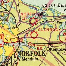
Glenrock Airport, as depicted on the 1935 Norfolk Sectional Chart (courtesy of Roger Connor).
This small general aviation airport was located on the eastern edge of the city of Norfolk.
The date of construction of Glenrock Airport has not been determined.
According to the book "Virginia Airports" by Vera Rollo & Norman Crabill (published by the VAHS),
"This airfield was operating in June 1930 for rides in a Ford Trimotor."
A commercial license was applied for in 3/18/32, approved in 4/11/32 to United Flyers Inc.,
and approved in 12/6/32 to J. C. Hudgins for commercial operations.
According to the Norfolk Airport web site, commercial flight operations moved to Glenrock Airport in 1932,
after the Navy had opposed the expansion of Norfolk's Granby Street Airfield
because of its proximity to flying operations at Norfolk Naval Air Station.
However, Glenrock's tenure as an airline airport didn't even last a single year,
as all commercial flights to Norfolk were suspended in 1932 due to the effects of the Great Depression.
Glenrock Airport was not yet depicted on the 1932 Washington-Hampton Air Navigation Map #4.
The earliest depiction of Glenrock Airport which has been located was on a 1935 Norfolk Sectional Chart (courtesy of Roger Connor),
which depicted Glenrock as a commercial or municipal airport.
The 1/1/36 Department of Commerce Airway Bulletin
described Glenrock Airport as a commercial field, consisting of a T-shaped sod field.
It was said to have 2 runways, measuring 2,450' northwest/southeast & 2,250' northeast/southwest.
The field was said to offer facilities for servicing aircraft, day only.
Glenrock was described in The Airport Directory Company's 1937 Airports Directory (courtesy of Bob Rambo)
as being a commercial airport, located on the North side of Virginia Beach Boulevard.
The field was described as having 2 sod & sand runways forming a "T" shape,
with the longest being a 2,600' northwest/southeast strip.
The earliest photo which has been located of Glenrock Airport was an 8/30/38 photo
of aviator Douglas "Wrong Way" Corrigan's 1929 Curtiss Robin in which he left Glenrock Airport.
Glenrock Airport was depicted as a commercial airport on the July 1941 Norfolk Sectional Chart (courtesy of Chris Kennedy).
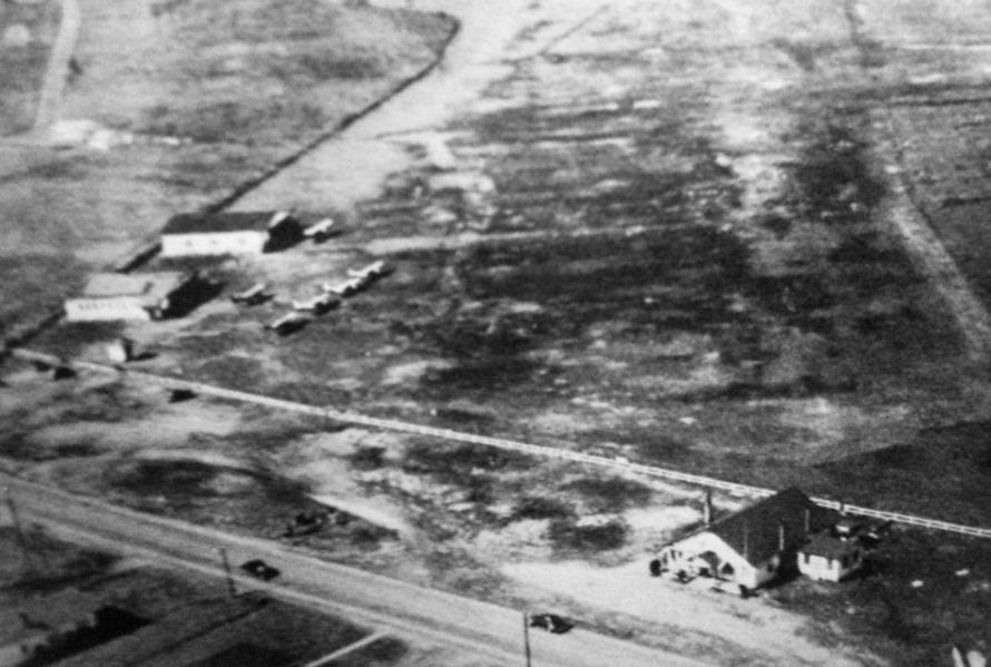
A circa 1940s aerial view depicted Glenrock Airport as having 5 light aircraft parked near 2 hangars on the side of an unpaved airfield.
Glenrock was also depicted as a commercial or municipal airport on the 1943 Regional Aeronautical Chart (courtesy of Chris Kennedy).
However, Glenrock may have been temporarily closed during WW2
(due to wartime security concerns, as was also the case at many other small civil airports during the war),
as it was not depicted at all on an August 1943 Navy map (courtesy of Mark Hess)
nor on the 1944 Regional Aeronautical Chart (courtesy of Chris Kennedy).
The 1945 AAF Airfield Directory (courtesy of Scott Murdock)
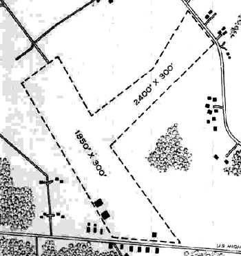
described Glenrock Airport as a 50 acre T-shaped property within which were 2 sod runways, measuring 2,400' northeast/southwest & 1,850' northwest/southeast.
The field was said to have one wooden 70' x 60' hangar,
although the diagram depicted a total of 3 buildings within the airfield property outline.
The field was said to be privately owned & operated.
Glenrock Airport was depicted as an auxiliary airfield on the April 1945 Norfolk Sectional Chart (courtesy of Chris Kennedy)
and the April 1946 Norfolk Sectional Chart (courtesy of Jim Stanton).
Elaine Blair recalled, “My father, Roy Sturgeon, was a Naval Pilot during WW2 & was separated from the Navy in September 1945.
After that he was operating his own aviation business of aircraft testing, inspection & ferrying service.
Private businesses were purchasing surplus Navy planes & he would ferry them to their new homes.
He was hired by a businessman, Mr. McBoyle of the Reedsburg Food Corp in WI, to help ferry one of the 2 planes he had purchased.
They left the Glenrock Flying School (according to the newspaper account) on 7/19/46.”
C. L. Batson recalled, “I was in the Civil Air Patrol at Glenrock Airport in 1952-55.”
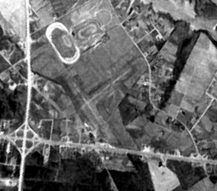
A 2/10/55 aerial view depicted Glenrock Airport as having 2 unpaved perpendicular runways.
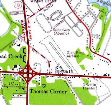
The most detailed depiction which has been located of Glenrock Airport was on the 1955 USGS topo map (courtesy of Adam DeLand).
It depicted “Glen Rock Airfield” as having a single 1,700' paved northwest/southeast runway.
The airport property was quite narrow, with 5 small buildings on the southwest corner.
The last aeronautical chart depiction which has been located of Glenrock Airport was on the January 1956 Norfolk Sectional Chart.
It depicted Glenrock as having a mere 1,700' paved runway.
Glenrock Airport was evidently closed at some point in 1956,
as it was no longer depicted on the July 1956 Norfolk Sectional Chart
According to the book "Virginia Airports" by Vera Rollo & Norman Crabill (published by the VAHS),
Glenrock's operating license was revoked & the airport was abandoned on 9/20/57.
C.L.Batson recalled, Glenrock Airport “was closed to make room for the JANAF Shopping Center.”
According to an article in the Virginian-Pilot (courtesy of Don Michalek),
"In 1959, JANAF opened as a commercial shopping area.
The name stands for Joint Army Navy Air Force & was an acronym for the original investors,
a group of retired and active-duty military, according to the center's Web site."
The Glenrock Airport was no longer listed among active airfields in the 1962 AOPA Airport Directory,
A 1963 aerial photo showed the shopping center which had covered the site of Glenrock Airport,
as did the 1965 USGS topo map.
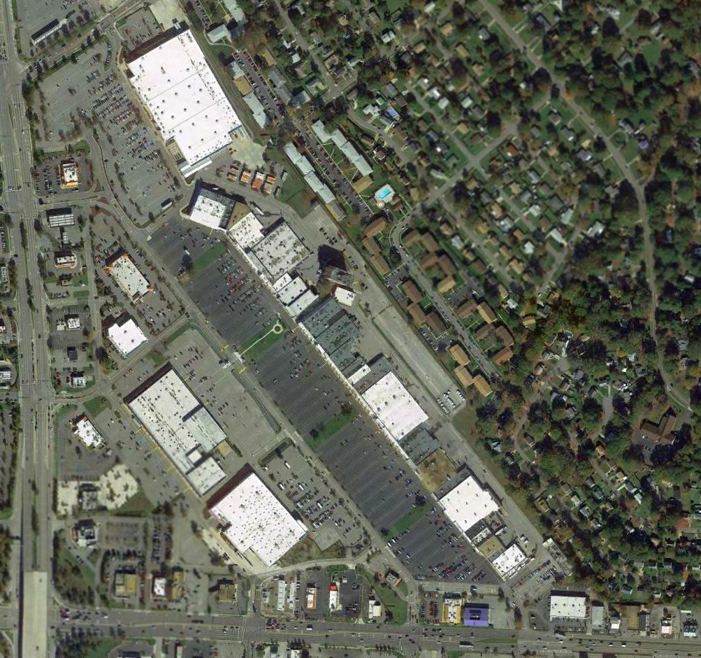
As seen in a 2015 aerial photo, not a trace of Glenrock Airport appears to remain at the site.
The area has been heavily developed with retail shopping & other buildings.
Don Michalek observed, “It is speculated, and does sound logical, that the unusual angle that JANAF [Shopping Center] sits at
compared to the intersection of Military Highway & Virginia Beach Boulevard has to do with the original alignment of the paved runway for Glenrock.”
The site of Glenrock Airport is located northeast of the intersection of Virginia Beach Boulevard & North Military Highway,
across Virginia Beach Boulevard from the Military Circle Mall.
____________________________________________________
Whitehurst Naval Outlying Landing Field, Whitehurst, VA
36.915, -76.195 (North of Norfolk International Airport, VA)
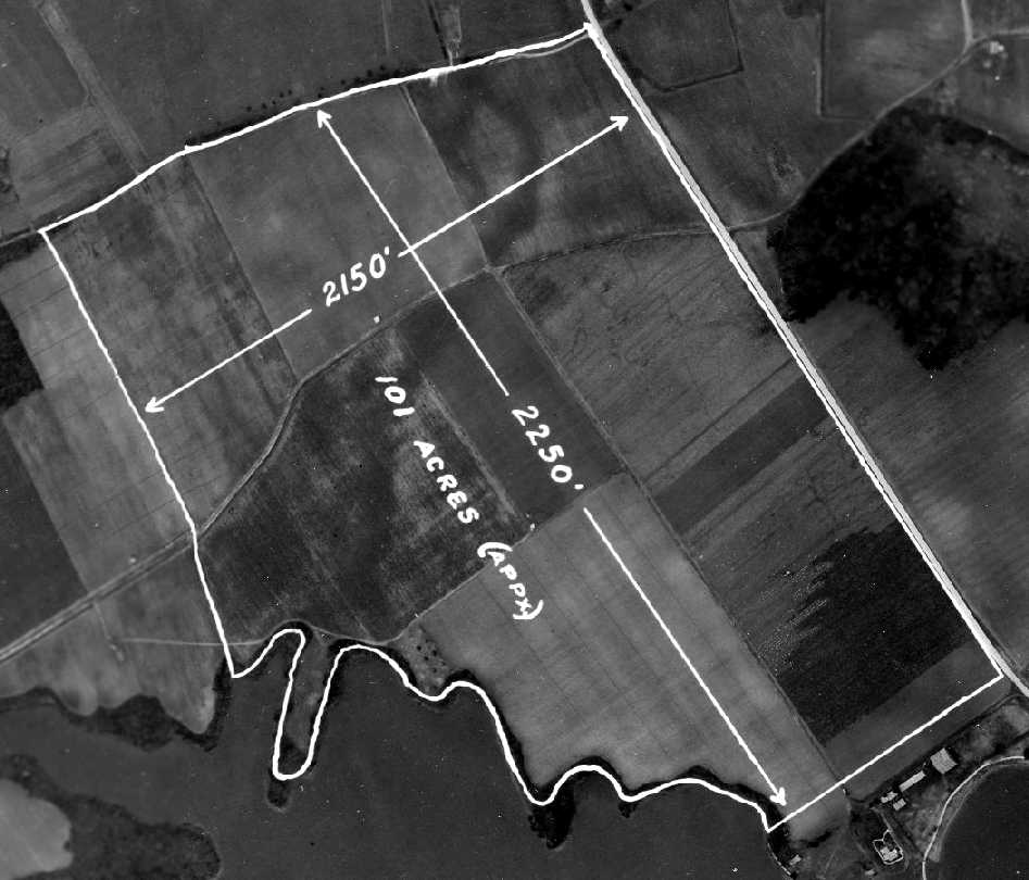
A January 1933 aerial view of the property which became Whitehurst NOLF (courtesy of Brian Rehwinkel).
This small military airfield was located only one mile north of the present-day Norfolk International Airport.
Whitehurst Field was not yet depicted on the 1932 Washington-Hampton Air Navigation Map #4.
The earliest depiction which has been located of the Whitehurst airfield site was a January 1933 aerial photo (courtesy of Brian Rehwinkel).
Brian observed, “The field is marked (by the Navy) to show what must have been the runway length for the property if used as an airfield
(although I don't believe the field was being used as a landing field at the time the picture was taken).”
The field was marked as measuring 2,250' x 2,150', consisting of 101 acres.
Brian reported, “I have seen reference to the field being used in 1939, and I believe it was used before that time.
I do know NAS Norfolk had auxiliary fields (OLFs) in the early- to mid-1930s (Glenrock Airport was one of those).
I am guessing, but based on this picture, it would not surprise me if the Navy used this field in the mid-1930s for one of those fields.
Of course, it is also possible this photo was taken for survey purposes and that the Navy did not use the field until later.”
However, Whitehurst was not depicted on the 1935 Norfolk Sectional Chart (courtesy of Roger Connor).
The earliest reference which has been located of the Whitehurst airfield being used was a series of Navy aircraft accident reports from 1937-41 (in the AAIR database, courtesy of Stewart Lanham).
According to Brian Rehwinkel, a Navy memo dated 5/8/42 at the National Archives indicated that Whitehurst "was first leased by the Navy in 1940.
The Navy leased the farm from the heirs of William Lee Whitehurst. The Navy paid the family an annual rent of $4,000 for the 125 acre parcel.
The documents also said the field was originally scheduled to be used as a LTA (Lighter-Than-Air) auxiliary field, based on the navy's field at Cape May, NJ.
Obviously, that never happened."
The Whitehurst airfield was not yet depicted at all on the March 1943 Norfolk Sectional Chart nor on an August 1943 Navy map (courtesy of Mark Hess).
The earliest aeronautical chart depiction which has been located of NOLF Whitehurst was on the September 1944 Norfolk Sectional Chart (courtesy of Ron Plante),
which depicted "Whitehurst (Navy)" as an auxiliary airfield.
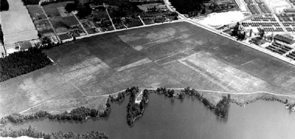
A 6/6/44 aerial view looking north at Whitehurst NOLF (courtesy of Brian Rehwinkel).
The field was depicted to be an open grass field, without any buildings or other improvements.
Brian observed, “Obviously, the [Normandy] invasion didn’t alter the Navy’s schedule in Norfolk on that day.
The caption for the photograph also refers to the OLF as 'Bee Farm'.”
Brian Rehwinkel observed, “Since this field was leased, it is very likely the lease was canceled at the end of the war.”
The last depiction of Whitehurst NOLF which has been located was on the October 1945 Norfolk Sectional Chart.
It depicted "Whitehurst" as an auxiliary airfield.
The Whitehurst airfield was apparently abandoned at some point between 1945-46,
as it was no longer depicted at all (even as an abandoned airfield)
on the April 1946 Norfolk Sectional Chart (courtesy of Jim Stanton) nor on the 1948 USGS topo map.
A 1963 aerial photo showed that housing had covered the southern half of the airfield site.
The 9/9/90 USGS aerial photo of the site did not reveal any traces of a former airfield.
A 4/7/10 aerial photo did not show any remaining trace of the former Whitehurst airfield.
Brian Rehwinkel observed in 2010, “The location today is covered by a strip shopping center & some nice residential housing.
The site is adjacent to the Little Creek Amphibious facility.”
The site of the former Whitehurst airfield is located southwest of the intersection of Route 170 & Shore Drive.
____________________________________________________
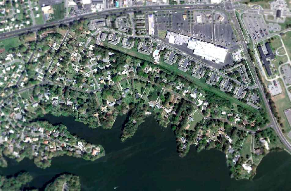
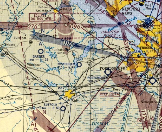
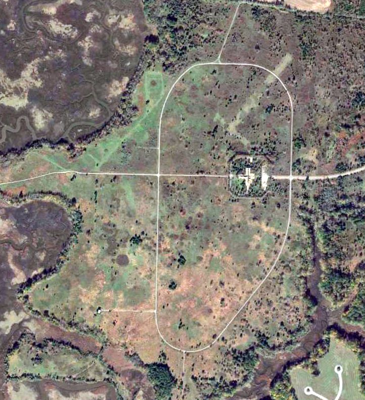
Monogram Naval Auxiliary Air Station, Driver, VA
36.82, -76.538 (West of Norfolk, VA)
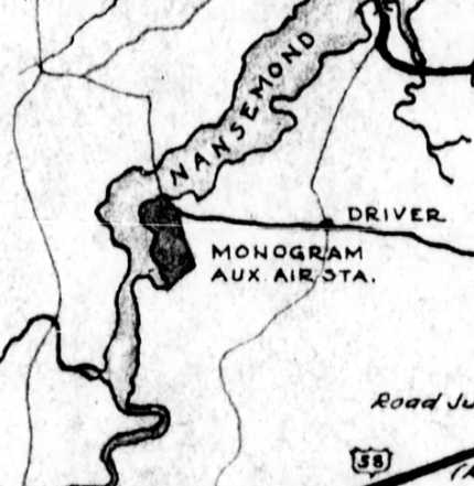
“Monogram Auxilliary Air Station”, as depicted on a August 1943 Navy map (courtesy of Mark Hess).
A 616 acre portion of the Monogram Farm in Driver, VA was leased by the Navy in 1939
to construct an Outlying Landing Field to support flying training at nearby Norfolk Naval Air Station.
The Navy had purchased the property by 1941.
The Monogram airfield had apparently not opened by the time of the July 1941 Norfolk Sectional Chart (courtesy of Chris Kennedy),
as it was not yet depicted.
The Monogram airfield at first had only grass runways.
Between late 1941 - early 1942, three squadrons (VB-8, VB-9, and VF-28) had conducted operational training at Monogram.
Construction of buildings began in late 1942 (although the runways remained unpaved),
and a Carrier Qualification Training Unit commenced operation.
An Acceptance & Transfer Unit relocated from NAS Norfolk to Monogram in early 1943,
and Monogram was commissioned as a auxiliary of Norfolk.
The Monogram airfield proved to be a disappointment,
as the grass runways were closed about 35% of the time due to drainage problems after a heavy rain.
That caused the ATU unit to be transferred to Franklin, VA in late 1943.
The airfield at Monogram was not depicted at all on the 1943 Regional Aeronautical Chart (courtesy of Chris Kennedy),
which may have been due to wartime security concerns.
The earliest depiction which has been located of the Monogram airfield
was on a August 1943 Navy map (courtesy of Mark Hess).
It depicted “Monogram Auxiliary Air Station” as an irregularly-shaped property.
According to Mark Hess, the Civil Air Patrol Tow Target Unit #21 was based at Monogram from 1943-44.
The earliest aeronautical chart depiction which has been located of the Monogram airfield
was on the September 1944 Norfolk Sectional Chart (courtesy of Ron Plante).
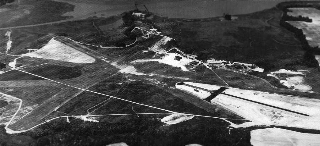
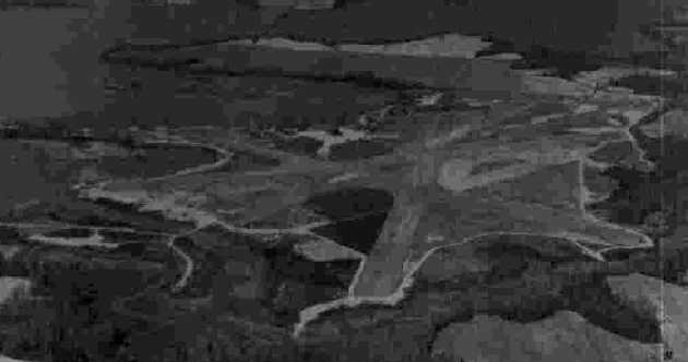
A WW2-era National Archives view looking west at Monogram NAAS.
The grass runways are on the left, and the paved catapult runway is on the right.
Monogram had 4 sod runways, ranging in length from 3,900' to 4,500'.
A ramp on the west side of the field had a single 111' x 58' hangar, with a control tower along one corner of the hangar.
The barracks at Monogram could accommodate a total of 230 personnel.
Monogram operated 2 aircraft for liaison purposes (a GH Howard, NE Piper, or SNJ Texan).
Monogram also provided crash crews & work parties for the nearby NOLF Suffolk.
Due to Monogram's grass runways, it was the designated landing field for all Navy aircraft in the Norfolk area
with hung bombs or those which had to perform a wheels-up landing.
The Civil Air Patrol operated from Monogram from late 1943 - middle 1944.
The grass runways at Monogram were finally upgraded in 1944,
when the Seabees installed a catapult & arresting system (with a 1,500' paved runway) on the north side of the grass runways.
Lillie Munford recalled, “My father & grandfather were civilian employees at Monogram during Www.
The were likely employed to construct buildings as both were carpenters.
We had a dog that my father brought home from Monogram & that the sailors had taught to drink beer.”
A 3/18/45 aerial view looking north from the 1945 AAF Airfield Directory (courtesy of Scott Murdock)
depicted at “Monogram NAAS” as having several runways.
The directory described Monogram as a 616 acre irregularly-shaped property
having 4 sod runways, with the longest being a 4,500' NNE/SSW strip.
The field was said to have a single 111' x 58' wood hangar, to be owned by the U.S. Government, and operated by the Navy.
The Navy began conducting night Field Carrier Landing Practice at Monogram in March 1945.
Monogram was closed by the Navy on 12/1/45.
The Monogram property was labeled “US Naval Installation” on the 1949 USGS topo map, but the airfield itself was not depicted.
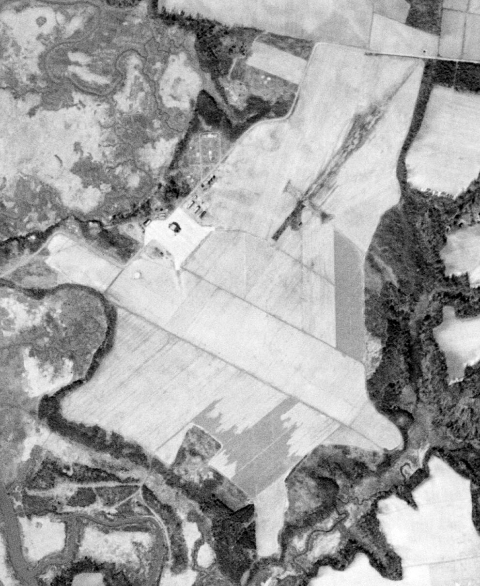
An 11/1/50 USGS aerial view showed the remains Monogram NOLF's catapult runway on the northeast part of the site,
and the cleared area of the former grass runways to the southwest.
The last aeronautical chart depiction which has been located of the Monogram airfield was on the August 1952 Norfolk Sectional Chart.
It depicted Monogram as having an 1,800' paved runway, but strangely it did not indicate any military afiliation.
Monogram was no longer depicted at all (even as an abandoned airfield) on the January 1953 Norfolk Sectional Chart.
According to Tim Tyler, NAVCOMMSTA Norfolk's Naval Radio Transmitting Facility Driver was built on the grounds of the former NAAS Monogram.
The Driver facility provided radio transmitting facilities & services to support Naval ships, submarines, and aircraft.
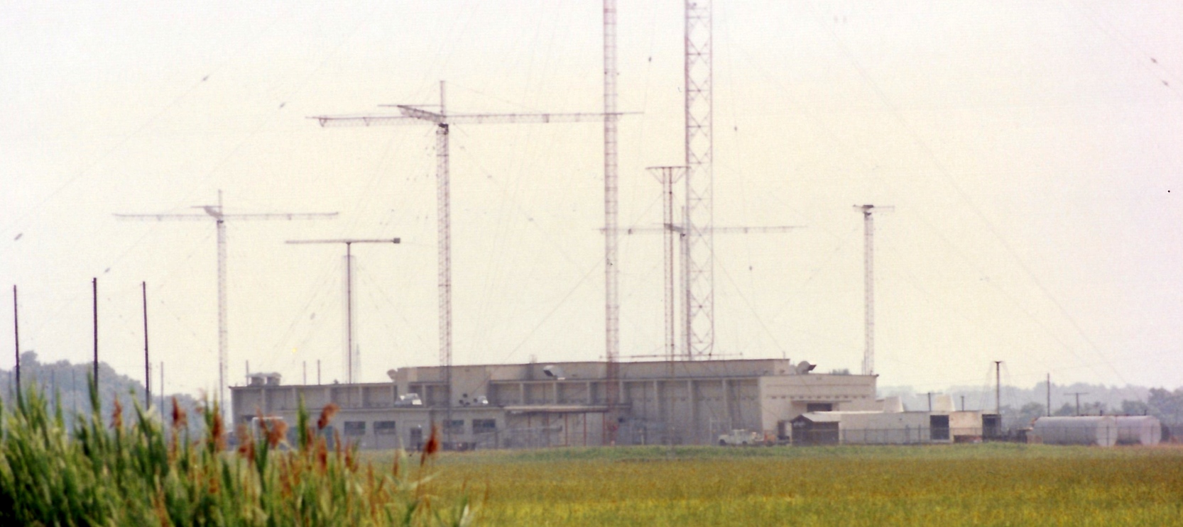
A 1992 photo by Tim Tyler taken from the NAVRADSTA(T) Driver main gate, showing the antennae built over the former Monogram airfield.
By 1992 the site contained many HF antennas, some LF antennas, and some old buildings left over from the NAAS days.
The communications facility was shut down in 1994.
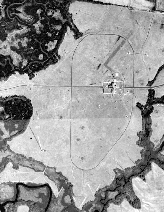
In the 1994 USGS aerial photo the remains Monogram NOLF's catapult runway could still be barely perceived stretching from center of photo to top-right.
The longest remaining runway segment was 1,500' long.
According to Tim Tyler, the 248 acres were turned over to City of Suffolk in July 2001 to be developed into a park.
Driver resident Janet Gibbons reported in 2004 that the site of the Monogram airfield has not yet been made into a park,
"but it has several housing developments sprouting up around it & will probably be a park someday."
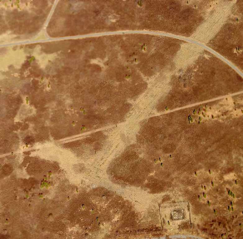
A circa 2005-2006 aerial view looking north at the remains of the catapult runway at Monogram.
A 2015 aerial photo showed the characteristic outline of the Monogram NOLF catapult runway could still be recognized on the northeast part of the airfield site.
Tim Tyler reported in 2020, “At least parts of the main building [the Navy Driver radio facility] remain, albeit heavily damaged by natural human elements in what's now an overgrown area.
The City has planned on making it into a parkland or specifically a sports park for over 20 years that I've been occasionally checking on the old site,
but those decades-old magnificent plans haven't become reality.”
Thanks to Tim Tyler for pointing out this airfield.
See also:
http://www.epa.gov/reg3hwmd/npl/VA9170022488.htm
http://www.dtic.mil/envirodod/derpreport96/vol2/appx/app-a/nara047.html
____________________________________________________
Since this site was first put on the web in 1999, its popularity has grown tremendously.
If the total quantity of material on this site is to continue to grow,
it will require ever-increasing funding to pay its expenses.
Therefore, I request financial contributions from site visitors,
to help defray the increasing costs of the site
and ensure that it continues to be available & to grow.
What would you pay for a good aviation magazine, or a good aviation book?
Please consider a donation of an equivalent amount, at the least.
This site is not supported by commercial advertising –
it is purely supported by donations.
If you enjoy the site, and would like to make a financial contribution,
you
may use a credit card via
![]() :
:
Please consider checking the box to make a monthly donatation.
For a mailing address to send a check, please contact me at: paulandterryfreeman@gmail.com
If you enjoy this web site, please support it with a financial contribution.
please contact me at: paulandterryfreeman@gmail.com
If you enjoy this web site, please support it with a financial contribution.
____________________________________________________
This site covers airfields in all 50 states.