
Abandoned & Little-Known Airfields:
Virginia: Virginia Beach
© 2002, © 2025 by Paul Freeman. Revised 11/9/25.
This site covers airfields in all 50 states: Click here for the site's main menu.
____________________________________________________
Please consider a financial contribution to support the continued growth & operation of this site.
Creeds NOLF (revised 11/9/25) - Fort Story Aux AAF (revised 11/9/25) - Pungo NOLF (revised 11/9/25) - Thalia Airport (added 8/21/23) - (Original) Virginia Beach Airport (revised 11/9/25)
____________________________________________________
(Original) Virginia Beach Airport, Virginia Beach, VA
36.839, -76.094 (Southeast of Norfolk, VA)
The original Virginia Beach Airport, as depicted on the April 1947 Norfolk Sectional Chart.
The original Virginia Beach Airport was evidently established at some point between 1946-47,
as it was not yet depicted on the October 1946 Norfolk Sectional Chart.
The earliest depiction which has been located of the original Virginia Beach Airport was on the April 1947 Norfolk Sectional Chart.
It depicted Virginia Beach Airport as a commercial/municipal airport, about 3 miles west of NAS Oceana.
Roland Gilliam recalled, “Virginia Beach Airport... the grass strip was perpendicular to Virginia Beach Boulevard on the south side, in the vicinity of Aragona Village.
I saw a Piper J3 Cub cross over Virginia Beach Boulevard landing at this airport. It hit a power line at the end of the runway, burst into flames. My father stopped at the crash.”
The original Virginia Beach Airport was not depicted on the 1948 or 1955 USGS topo maps.

The only photo which has been located of the original Virginia Beach Airport was a circa 1940s/50s aerial view (courtesy of Charles Cope),
showing 15 light single-engine planes parked near a arch-roof hangar which had “Virginia Beach Airport Stinson” painted on its roof.

A circa 1940s/50s advertisement described Virginia Beach Airport as being on Virginia Beach Boulevard at Rosemont,
offering flight training, Stinson & Cub sales & service, and charter flights.

The last aeronautical chart depiction which has been located of the original Virginia Beach Airport was on the July 1951 Norfolk Sectional Chart.
It depicted Virginia Beach Airport as having a 4,200' unpaved runway.
The original Virginia Beach Airport was evidently closed (for reasons unknown) at some point between 1951-52,
as it was no longer depicted on the January 1952 Norfolk Sectional Chart.

A 12/8/59 USGS aerial view of the original Virginia Beach Airport site (courtesy of Charles Cope), showed the hangar & paved taxiway remained intact.
The runway was presumably extended to the southeast.
The original Virginia Beach Airport hangar remained standing in a 1963 aerial view.
A 1982 aerial view showed the site of the original Virginia Beach Airport had been covered by Interstate 264.

A 2023 aerial photo showed no remaining trace of the original Virginia Beach Airport.
The original Virginia Beach Airport site was located along Paladin Drive, south of Interstate 264.
Thanks to Roland Gilliam for pointing out this airfield.
____________________________________________________
Thalia Airport, Virginia Beach, VA
36.851, -76.123 (Southeast of Norfolk, VA)
Thalia Airport, as depicted on the April 1947 Norfolk Sectional Chart.
Thalia Airport was evidently established at some point between 1946-47,
as it was not yet depicted on the October 1946 Norfolk Sectional Chart.
The earliest depiction which has been located of Thalia Airport was on the April 1947 Norfolk Sectional Chart.
It depicted Thalia as a commercial/municipal airport, only a mile northwest of another small general aviation airport, Virginia Beach Airport.
Thalia Airport was not depicted on the 1948 or 1955 USGS topo maps.

The last aeronautical chart depiction which has been located of Thalia Airport was on the January 1950 Norfolk Sectional Chart.
It depicted Thalia as having a 2,300' unpaved runway.
Thalia Airport was evidently closed (for reasons unknown) at some point in 1950,
as it was no longer depicted on the July 1950 Norfolk Sectional Chart.
A 1958 aerial view showed a residential neighborhood had covered the Thalia Airport site, but traces of what may have been a northeast/southwest runway were perceptible.

A 2023 aerial photo showed no remaining trace of Thalia Airport.
Thanks to Roland Gilliam for pointing out this airfield.
____________________________________________________
Fort Story Auxiliary Army Airfield, Cape Henry, VA
36.925, -76.03 (North of Virginia Beach, VA)

A January 1959 photo by Tom Pesnicak showing Fort Story Aux AAF on the right side of the clearing.
Fort Story is located at the tip of Cape Henry, where the Chesapeake Bay meets the Atlantic Ocean.
The Fort was established in 1914, as a coastal artillery site, intended to protect the entrance to the Chesapeake Bay.
These defenses were considerably expanded during WW2,
with many heavy guns mounted in fortified concrete batteries (the remnants of which still exist today).
After WW2, Fort Story eventually became the home to the Army's Transportation Command.
At some point between 1956-57, a small auxiliary airfield was constructed at Fort Story.
The purpose of the airfield is unknown.
Dean Speir recalled, “The 'field' named for my father, Colonel Frank Speir...
[following] his death in a Beechcraft Bonanza over an aerodrome in Dunkirk, NY,
the Army sought to honor him & 'ground-breaking' fights in & out of Fort Story.
'Speir Field' was dedicated in his memory in September 1957.”
Tom Pesnicak recalled, “I lived on Ft. Story as a boy & our home was to one side of the runway.
We lived there from December 1957 until the Spring of 1961.
The airfield when we lived there was Pierced Steel Plating, and the aircraft I most remember landing there where Bird Dogs, later nomenclature O-1E, back then L-19.
They used to drive the BARCs [Barge, Amphibious Resupply, Cargo] right down our street & across the one end of the runway.”
The earliest depiction which has been located of Ft. Story Airfield was a January 1959 photo by Tom Pesnicak.
The Ft Story airfield was not yet depicted on the July 1960 Norfolk Sectional Chart.

The earliest aeronautical chart depiction of Fort Story Aux AAF which has been located was on the January 1961 Norfolk Sectional Chart.
It depicted Fort Story Aux AAF as having a single 1,900' east/west paved runway.

The earliest aerial view which has been located of the Ft. Story Airfield was a 3/3/63 USGS aerial photo.
It depicted Fort Story as having a single east/west asphalt runway, with a grid of a large number of small buildings on the south side of the runway.
There did not appear to be any aircraft on the field.

The 1964 USGS topo map depicted Fort Story Aux AAF as a single paved northwest/southeast runway, labeled simply as “Airstrip”.

The September 1966 Norfolk Sectional Chart depicted Fort Story Aux AAF as having a single 1,900' paved east/west runway.
Paul Stroman recalled, “There was a landing strip at Ft. Story. I used to fly an L-19 from Ft. Eustis to there in 1966.”
Fort Story Aux AAF was still depicted on the September 1967 Washington Sectional Chart, and described as having a 1,900' runway.
Fort Story Aux AAF was still depicted on the 1969 USGS topo map.
However, it was evidently closed at some point between 1969-70, as it was labeled "Closed" on the 1970 Washington Sectional Chart (courtesy of John Clifford).
Navy pilot Michael Strobach recalled, "We used charts we called JOGs when we flew around at night on NVGs.
These JOGs were an excellent resource for abandoned airfields. Kind of like the US topographical maps.
I first noticed a field listed as 'Speir' on the tip of Cape Henry, and the runway length was listed as 1,500'.
I used to fly my CH-46 over Fort Story & try to make out the field outline every time I flew over.
I even visited it on the ground, much to my patient wife's frustration!
There isn't anything on the ground that gives a clue to its history. There is a clearing in the foliage & a long flat area."
"I also noticed that in the VFR Supplement that we fly with, the helo pad at Fort Story is named 'Speir'. They must have transferred the name."
Dean Speir recalled, “'Speir Field' stood until sometime in the 1990s when the memorial stone & plaque were relocated and it became 'Speir Heliport'.
Sometime after its half-century anniversary, the Army decommissioned it,
and it would have stayed that way if my sister hadn't raised a minor stink."
By 1998, the Fort Story airfield was no longer depicted at all (even as an abandoned airfield) on Sectional aeronautical charts.

A 2023 aerial photo showed only the faintest traces of the former Ft. Story northwest/southeast paved runway.

A close inspection of the 2023 aerial photo reveals that aircraft are present on the Ft. Story Airfield site more than 55 years after the airfield closed,
as at least 8 aircraft are seen on the southeast side of the airfield site, including 3 light general aviation fuselages, an F/A-18 Hornet, and 4 AH-1 Cobras.
The purpose of these aircraft is unknown, but perhaps they are used for Special Ops training.
The site of Ft. Story Airfield is located southwest of the intersection of Atlantic Avenue & Vung Tau Street.
____________________________________________________
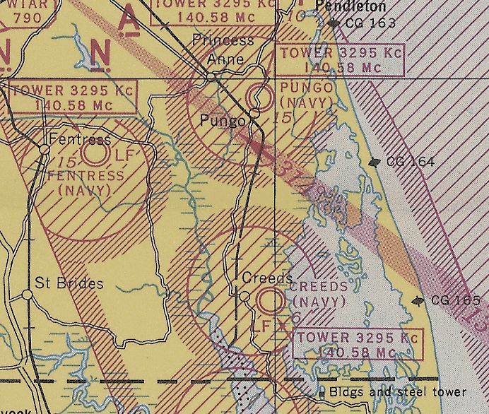
Pungo Naval Outer Landing Field, Virginia Beach VA
36.728, -76.012 (South of Oceana NAS)

“Pungo Auxiliary Air Station”, as depicted on an August 1943 Navy map (courtesy of Mark Hess).
There was no predecessor civilian airport at Pungo before WW2.
Stuart Chaplain reported, “The [Navy] airfield was the first - there was no previous airfield.
It was all farmland & I hoed too much corn to not know that.”
No airfield at this location was depicted on the 1939 USGS topo map,
the July 1941 Norfolk Sectional Chart (courtesy of Chris Kennedy),
nor the 1943 Regional Aeronautical Chart (courtesy of Chris Kennedy).
Pungo NOLF was commissioned in 1943 as a satellite airfield for nearby Norfolk Naval Air Station.
The station's intended mission was to support operations & training
of aircraft intended to operate from escort carriers.
A total of 24 such squadrons passed through Pungo during WW2,
most consisting of TBF or TBM Avenger torpedo bombers
and F4F or FM Wildcat fighters.
The earliest depiction which has been located of the Pungo airfield
was on an August 1943 Navy map (courtesy of Mark Hess).
The earliest aeronautical chart depiction which has been located of the Pungo airfield
was on the September 1944 Norfolk Sectional Chart (courtesy of Ron Plante).
Pungo's facilities were expanded in 1944.
At its wartime height, the airfield consisted of three 2,500' concrete runways, taxiways, 2 large concrete ramps, and a total of 82 buildings.
The station had a complement of up to 1,400 men.

An April 1944 aerial view looking northwest at NAAS Pungo, showing an airfield with 3 concrete runways, and a ramp filled by Navy aircraft.

A WW2-era view of Pungo, looking northeast (National Archives photo), with the ramp filled by Navy aircraft.

A 10/11/44 aerial view by Paul Brehm of NAAS Pungo (from the National Museum of Naval Aviation).

An undated aerial view looking southeast at Pungo Field from the January 1945 “History of Naval Air Bases, 5th ND” (courtesy of John McDonald)
depicted over a dozen single-engine Navy aircraft on Pungo's northwest ramp, along with numerous buldings.

A 3/18/45 aerial view looking northeast at Pungo NAAS from the 1945 AAF Airfield Directory (courtesy of Scott Murdock)
depicted the field as having 3 paved runways, with a large number of aircraft parked on the northwest ramp.
The 1945 AAF Airfield Directory (courtesy of Scott Murdock) described Pungo NAAS as “Inactive”.
The field was said to consist of a 441 acre irregularly-shaped property within which were three 2,500' concrete runways.
The field was said to have a single 111' x 53' wooden hangar,
to be owned by the U.S. Government & operated by the Navy.
"Pungo (Navy)" was still depicted on the April 1945 Norfolk Sectional Chart (courtesy of Chris Kennedy).
Following the end of the war, Pungo was disestablished by the Navy in 1945.

Pungo may have been operated for some period of time as a civil airport,
as "Pungo" was depicted as an auxiliary airfield (but not military) on the October 1945 Norfolk Sectional Chart.

The last aeronautical chart depiction which has been located showing Pungo as an active airfield
was on the April 1946 Norfolk Sectional Chart (courtesy of Jim Stanton).
It continued to depict Pungo as an auxiliary civilian airfield.
Dean Speir recalled, “When we were at Fort Eustis in 1946, my dad started flying, and found it expedient to travel that way between Forts Eustis & Story.
Problem was, there was no landing strip there, other than Pungo, the decommissioned Naval aerodrome some miles distant.
When we were stationed at Fort Story later that year, he used to house the Bellanca at Pungo... and that was pretty deserted.”
A 1953 aerial photo showed 2 buildings remaining to the northwest of the Pungo ramp.

The 1954 USGS topo map depicted “Pungo Field (Abandoned)” as having 3 paved runways, taxiways, ramps, and several buildings.
According to Cort Tompkins, "When the facility was disestablished by the Navy,
the land immediately surrounding the airstrip was sold as farmland.
This now private farmland includes the apron at the end of the longest runway,
to which the Navy would taxi its fighters to sight in their 0.50 caliber machine guns
into a concrete-encased earthen berm 200-300 yards distant.”

A 11/20/59 USGS aerial photo showed Pungo Field remained in an unchanged condition.
The Pungo airfield was labeled "Aband arpt" on the 1961 Norfolk Sectional Chart (according to Chris Kennedy).
A 1963 aerial photo appeared to show the abandoned airfield in an unchanged condition,
with 2 buildings remaining to the northwest of the Pungo ramp.
According to Cort Tompkins, "After its disestablishment by the Navy, the berm became an informal shooting range,
until the early 1970s when the farmer who then owned that portion of the airport
leased the area around the berm to the then newly-formed Virginia Beach Rifle & Pistol Club."
At some point between 1963-99, the Pungo property was turned over to the Coast Guard,
which constructed a radio transmitter site over much of the former airfield.
This facility is still in use today by the Coast Guard.
There are many radio towers spread throughout the airfield property,
along with several maintenance buildings situated along the west side of Runway 4/22.

An 11/99 aerial photo by Paul Freeman looking northwest at the Pungo airfield, taken from a Diamond Katana DA20A-1.

A 7/00 photo by Paul Freeman looking north at the entrance to the current Coast Guard facility at the Pungo airfield.

A 7/00 photo by Paul Freeman of the view along Runway 4, showing radio towers & maintenance buildings along west side of runway.
Paul Freeman visited the site of the Pungo airfield in 2000.
A public road intersects the northern end of Runway 18/36, and runs over a portion of the taxiway before turning north just before the main ramp area.
All of the runways, taxiways & ramps still existed, in excellent condition.
As of 2000, the Pungo airfield was not depicted at all (even as an abandoned airfield) on current aviation charts,
but was shown as an airfield on local road maps.
Cort Tompkins reported in 2004 that the earthen berm at Pungo remains in use by the Virginia Beach Rifle & Pistol Club "to this day (imagine all the lead in there!).
Sadly, that portion of the former airport is now being sold to a residential developer -
who will have to find a way to remove the berm as well as several WWII-era bunkers near the airstrips!"
The portion of the airstrip currently retained by the USCG will remain with the USCG.
Also interesting is that the CG-owned portion of the airstrip has now been encircled
with a make-shift wall of huge chunks of concrete debris placed inside the property's chain-link fence.
This likely occurred as a post-9/11 security measure."

A circa 2005 aerial view looking north at the ramp & several runways at the Pungo airfield.

A 5/30/10 photo by Don Michalek of an abandoned building at the site of the Pungo airfield.
Don reported, “Over the memorial weekend, the Pungo community opens up the old Pungo NAAF to use as a parking area for the Pungo Strawberry Festival.
Its a rare opportunity to go 'exploring' around the old field.”

A 5/30/10 photo by Don Michalek “looking around the corner of a road that emptied onto the tarmac.”
James Gant reported in 2011, “Pungo Airfield is also now host to an Sports Car Club of America autocross event, and has been for quite some time now.
The event is run by the Old Dominion Region of the SCCA.”
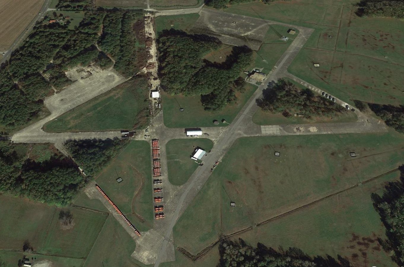
A 2015 aerial view looking north shows the Pungo airfield remains intact.

A 10/22/17 aerial view by Boom Powell from a Stearman looking west at the Pungo airfield.
Boom reported, “Pungo sees little activity & the Coast Guard's orange storage containers make it easy to point out.
I always point out that the Wildcat (FM-2) in our museum [the Virginia Beach Military Aviation Museum] was based there in 1945.”

A pre-2022 aerial view looking north at the odd sight of single-family houses which have been built within a few feet of the former Pungo airfield pavement.

A 2023 photo looking southwest at the remains of the Pungo north ramp.
____________________________________________________
Creeds Naval Outer Landing Field (64VA), Creeds VA
36.605, -76.007 (South of Oceana NAS)

A circa 1941-43 aerial view looking south at Creeds (courtesy of Mark Hess).
Creeds NOLF is located south of Pungo NOLF, along the Atlantic Coast.
No airfield was depicted at this location on the 1939 USGS topo map.
The Navy began construction at the site in mid 1940 of an Outlying Landing Field to support training operations at NAS Norfolk.
The airfield at Creeds was not depicted at all on the July 1941 Norfolk Sectional Chart (courtesy of Chris Kennedy) or the March 1943 Norfolk Sectional Chart.
The earliest depiction which has been located of Creeds was a circa 1941-43 aerial view looking south (courtesy of Mark Hess).
It depicted the field as having 3 paved runways, with a number of aircraft on a paved ramp on the north side.
Creeds was commissioned on 4/5/43 as an auxiliary of NAS Norfolk,
with its mission being the support, operations, training, and maintenance of fleet squadrons.
“Creeds Auxiliary Air Station”, as depicted on an August 1943 Navy map (courtesy of Mark Hess).
The Navy had intended Creeds to function as a base for composite squadrons of Wildcats & Avengers that would eventually serve on small CVE escort carriers.
The first squadron to arrive at Creeds was VF-1 (appropriately enough!), followed by VC-52, VB-8, VF-13, and VB-15 throughout 1943.
In early 1944, composite squadrons VC-15, VC-95, and VC-42 had passed through Creeds.
The complement at Creeds reached a total of 1,383 personnel in 1944. The station was assigned 2 base aircraft, usually GH Howards.

The earliest aeronautical chart depiction which has been located of the Creeds airfield was on the May 1944 Norfolk Sectional Chart.
CAG-27, CAG-28, and VT-153 were based at Creeds in early 1945.
An expansion program in early 1945 included the installation of permanent lighting,
additional barracks, and additional aircraft parking areas.
The Creeds airfield eventually consisted of 3 concrete runways (the longest being 2,500'), taxiways, and a large ramp area.
The construction program was completed on 8/1/45, just in time for the end of WW2.

A WW2-era view of Creeds, looking south (National Archives photo), with a large number of Navy aircraft parked on the ramp.

A 3/15/45 aerial view looking north at Creeds NAAS from the 1945 AAF Airfield Directory (courtesy of Scott Murdock)
depicted the field as having 3 paved runways, with a large number of aircraft parked on the northeast ramp.
"Creeds (Navy)" was still depicted on the April 1945 Norfolk Sectional Chart (courtesy of Chris Kennedy).
The 1945 AAF Airfield Directory (courtesy of Scott Murdock) described Creeds NAAS as inactive.
The field was said to consist of a 272 acre irregularly-shaped property within which were three 2,500' concrete runways.
The field was said to have 2 wooden hangars (111' x 59' & 77' x 20'), to be owned by the U.S. Government & operated by the Navy.
Following the end of WW2, Creeds may have been operated for some period of time as a civil airport,
as "Creeds" was depicted as an auxiliary airfield (but not military) on the October 1945 Norfolk Sectional Chart.
Creeds was decommissioned by the Navy on 10/15/45.
Creeds was depicted as an auxiliary civilian airfield on the April 1946 Norfolk Sectional Chart (courtesy of Jim Stanton).
Some sources indicate that Creeds was still used by the Navy as an Outlying Landing Field into the 1950s (but perhaps this was in an unofficial capacity).

A 1/30/53 USGS aerial photo did not show any indication of recent aviation usage of Creeds Field.

The 1954 USGS topo map depicted “Creeds Field (Abandoned)” as having 3 paved runways, taxiways, ramps, and several buildings.
The Creeds property was conveyed by the Federal Government to the local government in 1961.
It was labeled "Aband arpt" on the 1961 Norfolk Sectional Chart (according to Chris Kennedy).
Thomas Belvins recalled, “ I can remember drag racing at Creeds from my high school days in the early 1960s.”
This reportedly continued into the early 1970s.

At some point between 1961-76 Creeds was apparently reused as a private civilian airfield,
as that is how "Creeds" was depicted on the November 1976 CG-21 World Aeronautical Chart (courtesy of Chris Kennedy).
It was depicted as having 3 paved runways, with the longest being 2,500'.
Don McMahon recalled, “I was a Police Officer in Virginia Beach during the mid-late 1970s
and I know that Creeds was used for organized drag racing on weekends;
we were detailed to it checking for underage drinking & crowd control.
We also used it for driver training, and got ‘buzzed’ once or twice by fighters doing touch & goes.
At the time there were more than a couple of hulks laying around in the woods.”
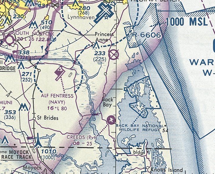
The last aeronautical chart depiction which has been located showing Creeds as an active airfield was on the March 1981 Washington Sectional Chart.
It depicted Creeds as a private civilian airfield having 3 paved runways, with the longest being 2,500'.
The use of Creeds as a private airfield evidently ended at some point between 1981-87,
as it was no longer depicted at all on the March 1987 Washington Sectional Chart.

A November 1999 aerial view by Paul Freeman looking southeast at the Creeds airfield.

A 7/00 photo by Paul Freeman of Creeds' Runway 35. Note wrecked cars along west side of runway.

A 7/00 photo by Paul Freeman of the main ramp area at the northeast portion of Creeds NOLF.
The sign gives the current name of the site - the "Forrest P Capps Law Enforcement Training Center",
whose complex of buildings are visible directly behind & to the right of the sign.
The property is used by the Virginia Beach Police Department as a training area.
They have a complex of trailers & other small buildings at the east end of Runway 8/26,
and abandoned cars & trailers are scattered about the ends of the other runways.

A 7/00 photo by Paul Freeman of the only remaining original building at Creeds: a curious little single-story concrete structure which sits along a circular concrete road
along the southern edge of the large ramp area at the north end of the airfield.
Two signs say: "Warning. Bio chemicals. Keep out. Gas mask eye protection required." The original purpose of this building is unknown.
As of 2002 the Virginia Beach Police Department also maintained the only remaining aviation use of the airfield:
a 500' x 175' portion of Runway 3/21 was occasionally used for operations by their Bell 206B helicopters, and was designated "Creeds Heliport" (VA64).
Although the Airport Facility Directory listed 2 helicopters as being based at the facility,
there was no evidence at the site to suggest any aircraft were currently based there.

The target adjacent to the east side of the airfield was Target #1, and the target further east was Target #2.
In recent aerial pictures, no trace remains of either of these targets.
Cort Tompkins reported in 2004, "the Virginia Beach (and formerly Princess Anne County) Sheriff's Department
(and now also Virginia Beach Police Department) up until very recently used a berm in that airstrip area as a firing range.
Due to complaints from residents (and bullets discovered in nearby homes),
the city is now constructing an alternate range in North Carolina.
Further, while the Police Department may land their helicopters at Creeds from time to time,
they are not stationed there (they're farther north, near the municipal center)."
Creeds was not depicted at all (even as an abandoned airfield) on current aviation charts, but shown as an airfield on local road maps.

A circa 2006 aerial view looking east at the north end of the Creeds airfield.

A circa 2006 photo looking south along the former Runway 17 at Creeds.
The Creeds Heliport was evidently closed at some point between 2002-2009,
as the facility was no longer listed with the FAA as a current heliport as of 2009.

A 2009 plan of the “VA Beach Police Department Law Enforcement Training Center Creeds” (courtesy of Christopher Epperson),
showing the road courses which are planned to be overlaid on the former runways & taxiways.
Christopher reported in 2009, “We are about to reopen the police training facility at Creeds.”
He also indicated that plans were being made to commemorate the Navy personnel who had used the Creeds airfield in years past.

A 2015 aerial view looking north at the Creeds airfield.

A 10/22/17 aerial view by Boom Powell from a Stearman looking west at the Creeds airfield.
Boom reported, “Creeds is used by the Virginia Beach Police for training.
I have fun asking pilots what the runway markings are... they are road markings. There is even a stoplight at one intersection.
The black area is a skidpad, there’s a training tower, and there’s an urban training area.”

A 2023 photo looking southwest down a former Creeds runway.
See also: http://pirs.mvr.usace.army.mil/fuds/m-p/navalax/preasses/inpr/11.htm
____________________________________________________
Or if you prefer to contact me directly concerning a contribution (for a mailing address to send a check),
please contact me at: paulandterryfreeman@gmail.com
If you enjoy this web site, please support it with a financial contribution.
____________________________________________________
This site covers airfields in all 50 states.