
Abandoned & Little-Known Airfields:
Eastern Washington State
© 2002, © 2026 by Paul Freeman. Revised 1/9/26.
This site covers airfields in all 50 states: Click here for the site's main menu.
____________________________________________________
Please consider a financial contribution to support the continued growth & operation of this site.
Ash Airport (revised 1/9/26) - Calkins Air Terminal (revised 9/22/23) - Clarkston Airport / Asotin County Airport (revised 5/27/23)
Curlew Airport (revised 11/25/20) - Dayton Airport (revised 2/8/23) - Lemen Airpark (added 12/16/25) - Northport Airport / James A. Lowry Municipal Airport (revised 5/1/23)
____________________________________________________
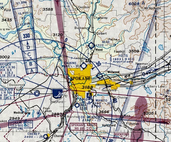
Lemen Airpark, Opportunity, WA
47.64, -117.213 (East of Spokane, WA)
Lemen Airpark, as depicted on the October 1945 Spokane Sectional Chart.
This little general aviation airport was evidently established at some point between 1944-45
(like hundreds of other small airports in the US post-WW2 aviation boom),
as it was not yet depicted on the 1944 Spokane Sectional Chart.
The earliest depiction which has been located of Lemen Airpark was on the October 1945 Spokane Sectional Chart.
It depicted Lemen as a commercial/municipal airport.

The earliest photo which has been located of Lemen Airpark (and the only photo showing it in operation) was a 12/1046 USGS aerial view.
It depicted Lemen as depicted as having a single northeast/southwest runway, with 5 light single-engine planes near some small buildings on the northeast corner.
An article by Tom Lutey entitled “Airpark idea still soars in imagination” in the 5/8/06 Spokesman-Review (courtesy of Jim Catalano) reported,
“Loren Lemen ran a crop-dusting & air mechanics business at 16th Avenue & Adams Road since the 1940s. As the housing boom of the late 1950s began filling Spokane Valley’s vacant lots, Lemen turned his attention to development.
But Lemen wasn’t interested in little boxes on the hillside. He wanted to build a neighborhood on his land in Veradale with a plane in every garage, a neighborhood for, as he told the news hounds who came gawking, 'air-minded' people.”
“More & more people, particularly businessmen, are using private planes to cut down traveling time,” Lemen told the Spokane Chronicle in 1955.
“We believe that a housing development designed especially for these & other air-minded people will be a definite service to the Valley.”
Reporters went wild with possibilities of a propeller-spun nuclear family living in Lemen Airpark.
“Pretty soon in Vera, it will be, ‘Dad, can I use the plane today?’ ” one reporter wrote. “Husbands will check over the family aircraft for signs of damage after wives have taxied the planes into hangars next to homes.”
The 300-home project broke ground in 1955 on 160 acres. The plan was for 34 homes on 2 streets paralleling the runway.
Each hangar was to have direct access to the airfield. Residents living off the runway were to be given space in a community hangar behind Lemen’s house.
The projected prices of the homes in the airpark seemed to go up with each report, from $12,000 to $15,000 in July 1955, to $50,000 that November. There were even plans for private parks complete with swimming pools.
“He was so far ahead of everybody else,” said Ed “Skeeter” Carlson, a Spokane pilot who landed at Lemen’s a time or two. He admired the airpark, but it was a little too rich for his blood.
“When I got out of the Army, most of my buddies were buying houses with their G.I. bills for $6,000,” said Carlson. “One guy bought an $8,000 house & we thought he was rich.”

The last depiction which has been located of Lemen Airpark was on the October 1955 Spokane Sectional Chart.
It depicted Lemen as having a 3,200' unpaved runway.
Lemen Airpark was evidently closed at some point between 1955-56, as it was no longer depicted on the April 1956 Spokane Sectional Chart.
A 1957 aerial view depicted Lemen soon after its closure.
A hangar with a segmented circle painted on its roof remained among some smaller buildings on the northeast corner, but all the planes were gone.
The alignment of the former runway was still recognizable, but residential streets had been laid out on either side.
According to the article entitled “Airpark idea still soars in imagination” in the 5/8/06 Spokesman-Review (courtesy of Jim Catalano),
“The airpark soon morphed into something else. Within a year of receiving county approval, the original plat was partially overlaid with a more modest, non-plane subdivision of 425 homes.
The new project, simply called Valley Park, kept the promise of a private park & pool but didn’t mention the runway.
By 1958, the last of Lemen Airpark was bought by Fidelity Savings & Loan, which didn’t limit sales to air-minded people.”

Lemen Airpark was still depicted on the1961 USGS topo map, even though it had evidently been closed for 5 years by that point.
It was depicted as having a single northeast/southwest runway, with 4 small buildings on the northeast corner.
According to the article entitled “Airpark idea still soars in imagination” in the 5/8/06 Spokesman-Review (courtesy of Jim Catalano),
“Loren Lemen, now 90, has a hard time explaining what happened to his neighborhood of the future.”
“It’s nothing that happened overnight,” said Lemen. “I already had the strip & so on & so on. In other words, it’s hard to understand.”
Today, from overhead you can still see where the runway used to be, though it is now filled in with split-level homes. Early Dawn & Airpark drives parallel the 3,200' strip.
There is a private park & a pool near 16th & Bolivar Road, just as promised by the neighborhood of tomorrow.
“I know our house is still there & our hangar,” said Loren’s wife, Lelah.
The neighborhood of tomorrow is the neighborhood of her past. When she talks about the airpark, she tells a more personal story, about Loren working out in the garage or taking off to go crop-dusting.
Inevitably, someone always called when her husband’s low-flying plane buzzed the Valley landscape; crop-dusters always fly low.
She talks about the winter months, when Loren would shoot coyotes from the sky & return home with their pelts tied to the struts of his plane.
And she talks about her son, Bill, and the other children in the neighborhood who would pile into a couple of broken-down planes on the Lemens’ property and, as she puts it, “go all over the world,” on the breeze of imagination.
They could even fly into the future.

A 2006 photo by Brian Plonka of Jim Nyborg walking in front of the Airpark Drive sign, in the Spokane Valley neighborhood that once was Lemen Airpark.

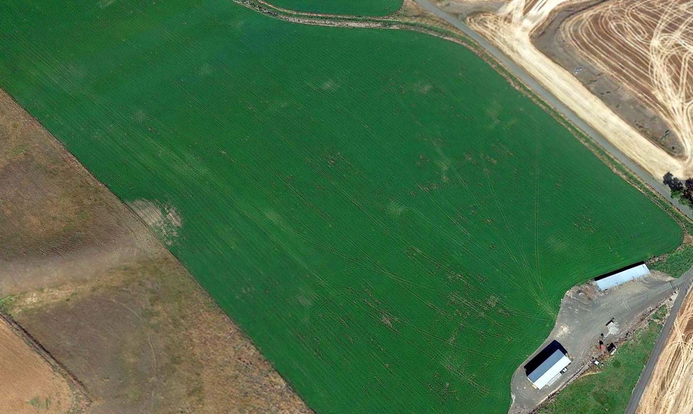
A 2023 aerial view looking south at the Lemen Airpark site showed the diagonal alignment of the former runway is still seen in the street layout, and the former hangar remains on the northeast corner (bottom-left of photo).

A 2025 photo of the former Lemen Airpark hangar which remains on the northeast corner of the site, on the southwest corner of 16th Avenue & Adams Road.
Today the site of the Lemen Airpark runway is commemorated via the name of the street overlaid on it, Airpark Drive.
Thanks to Jim Catalano for pointing out this airfield.
____________________________________________________
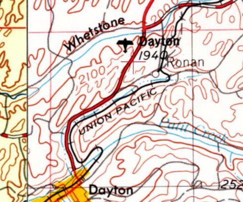
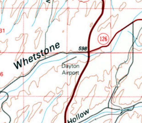
46.381, -117.948 (Southeast of Seattle, WA)

Dayton Airport, as depicted on the 1967 USGS topo map.
Yet another of America's thousands of vanished small grassroots airports.
Dayton Airport was evidently established at some point between 1958-67,
as it was not yet depicted on the 1958 USGS topo map.
The earliest depiction which has been located of Dayton Airport was on the 1967 USGS topo map.
It depicted a single paved northeast/southwest runway, labeled simply as “Landing Strip”.
Dayton Airport was not listed in the 1971 WA Pilot's Guide (courtesy of Scott Kimball).
Dayton Airport, as depicted on the 1974 USGS topo map.
The 1981 USGS topo map depicted Dayton Airport as having a single northeast/southwest runway.
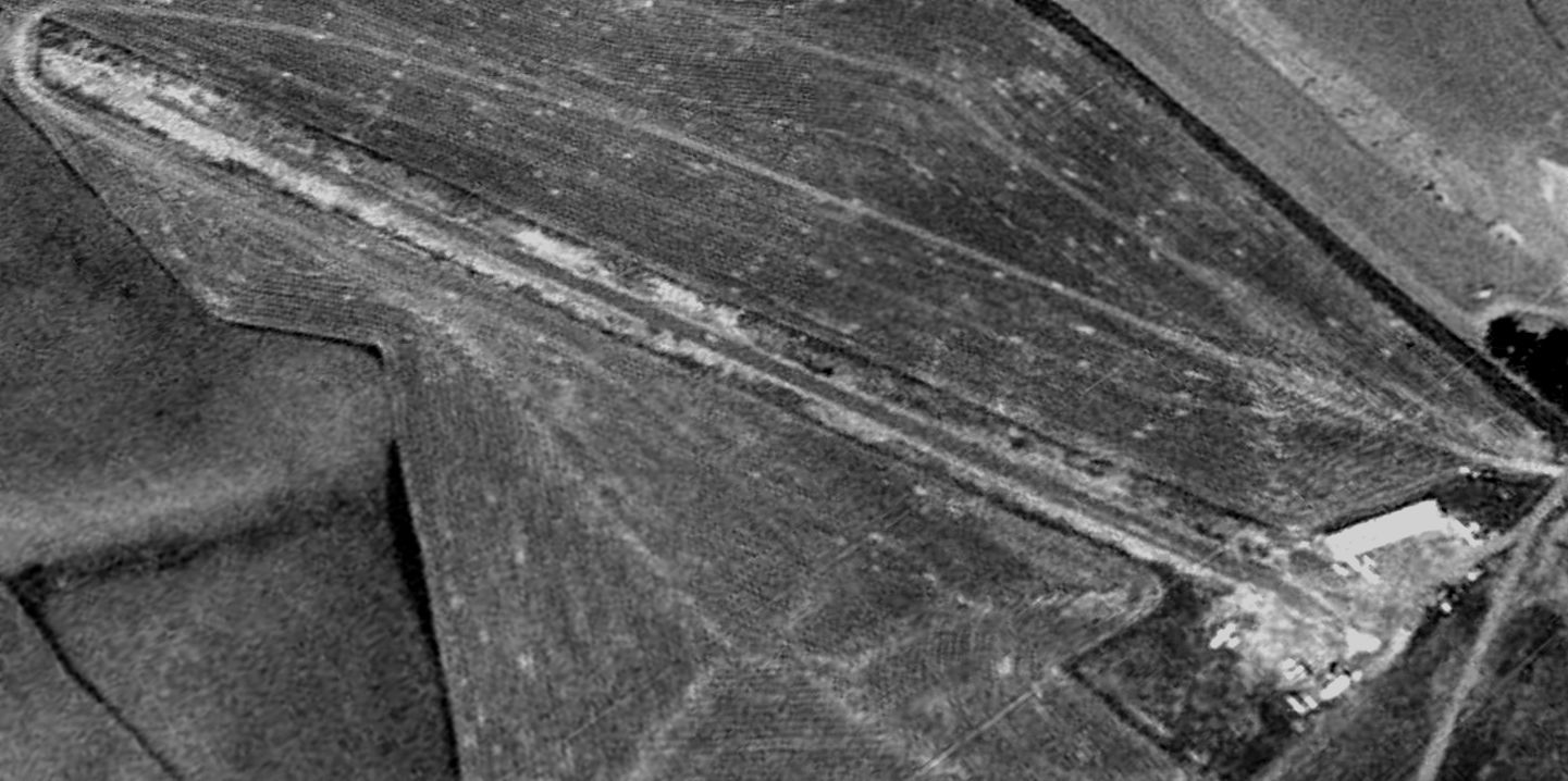
The earliest photo which has been located of Dayton Airport (and the only photo showing aircraft at the airport) was a 1996 USGS aerial view looking northwest.
It depicted Dayton Airport as having a single paved northeast/southwest runway,
with 3 light single-engine aircraft parked near a small building on the east side.
Dayton Airport was evidently closed (for reasons unknown) at some point between 1996-2003,
as a 2003 aerial view showed the runway was much less distinct, and no aircraft were visible.
A 2005 aerial view showed the Dayton Airport runway was no longer recognizable, with the land having been returned to cultivation.
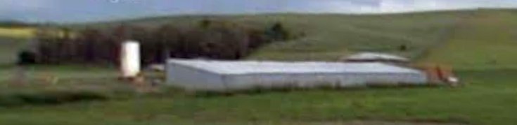
A 2009 photo looking southeast at the building (possible former hangar) on the east side of the Dayton Airport site.
A 2016 aerial view looking northwest showed 2 buildings remained on the east side of the Dayton Airport site,
but no trace remained of the former runway.
The site of Dayton Airport is located southwest of the intersection of Route 12 & Whetstone Road.
Thanks to Lee Corbin for pointing out this airfield.
____________________________________________________
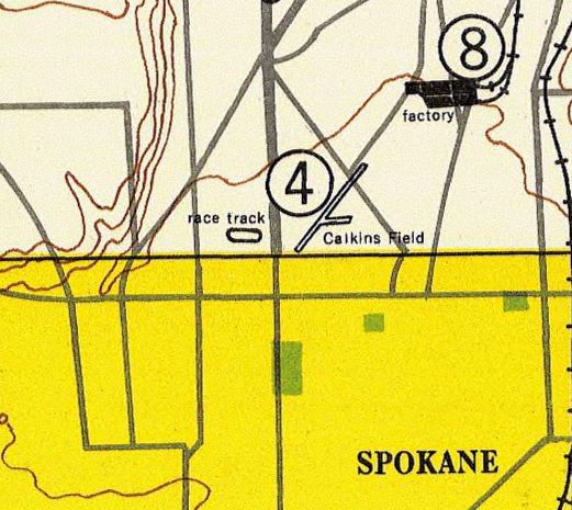
Calkins Air Terminal, Spokane, WA
47.72, -117.405 (North of Spokane, WA)
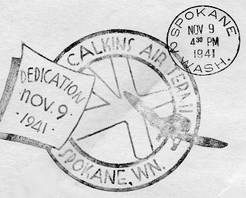
An 11/9/41 postmark commemorating the dedication of Calkins Air Terminal (courtesy of John Townsley).
According to Tuffy Luhr (from the essay “Tuffy's War” courtesy of John Townsley), “Just a few days before the beginning of the war, in 1941, Claude Calkins, opened Calkins Air Terminal.”
A 4/21/41 article in the Spokane Daily Chronicle (courtesy of John Townsley) stated that Calkins’ intent with Calkins Field
was to create “a fine airfield on which student flyers & private owners” could operate “without the risk of rubbing wings with army bombers or commercial transports.”
According to John Townsley, “Up until that point Felts Field was Spokane’s primary airport.
It had long combined commercial, military, and private aircraft.
But as various Chronicle articles published the summer before the outbreak of war indicated -
talks in support of the nation’s military buildup had begun between the army & Spokane’s city council
regarding the possibility of the military taking a lease that would give it 'complete control' over Felts Field.
After such control was granted, all further private use could be modified any time such conflicted with what the army considered 'military necessity.'
Any such operational modifications could leave the civilian lease holders & their businesses out in the cold.
Due to the concurrent development of the totally military Sunset Field (later renamed Geiger) to the west of Spokane, the army never exercised said military necessity.
But all the ongoing uncertainty surrounding Felts Field was likely to have made Calkins Field very attractive to private aircraft owners
during what would prove to be the last few months of peace.”
According to John Townsley, “Claude Calkins had started toward his vision by quietly buying individual parcels totally 800 acres north of Spokane.
This block of properties ran 1.5 miles north & one mile east from the corner of Division Street & Francis Avenue.
During the winter of 1940-41 trees were removed & the necessary grading done.
The first mile-long northeast/southwest landing strip - oriented to 'the direction of prevailing winds' - was completed at the beginning of May.
Plans called for another runway, this time running north/south to parallel Division Street, as well as a 3rd to trace the eastward march of France Avenue.”
Calkins Air Terminal was not yet depicted on the August 1941 Spokane Sectional Chart.
An 11/9/41 postmark (courtesy of John Townsley) commemorated the dedication of Calkins Air Terminal.
According to the Spokane Daily Chronicle, soon after the beginning of the war Calkins Field became a site for training flight instructors -
“first under the Civilian Pilot Training Service, then under the War Training Service.”
Tuffy & Orland’s eventual dealings with Calkins Field were in all probability associated with those programs.
The earliest aeronautical chart depiction which has been located of Calkins Air Terminal was on the January 1942 Spokane Sectional Chart.
It depicted Calkins as a commercial/municipal airport.
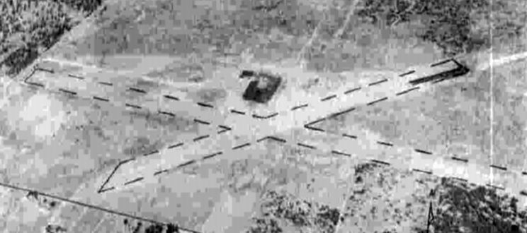
A circa 1943-45 aerial view looking north from the 1945 AAF Airfield Directory (courtesy of Scott Murdock) depicted Calkins Air Terminal as having 2 runways in an X-shape.
The 1945 AAF Airfield Directory (courtesy of Scott Murdock) described Calkins Air Terminal as a 960 acre irregularly-shaped property
having 2 sod & earth runways, the longest being the 5,280' east/west strip.
The field was said to have 3 hangars, the largest being a 100' x 50' wooden structure, and to be owned & operated by private interests.
The 1948 USAF Spokane Urban Area Chart (courtesy of John Townsley) depicted Calkins Field as having 2 runways.
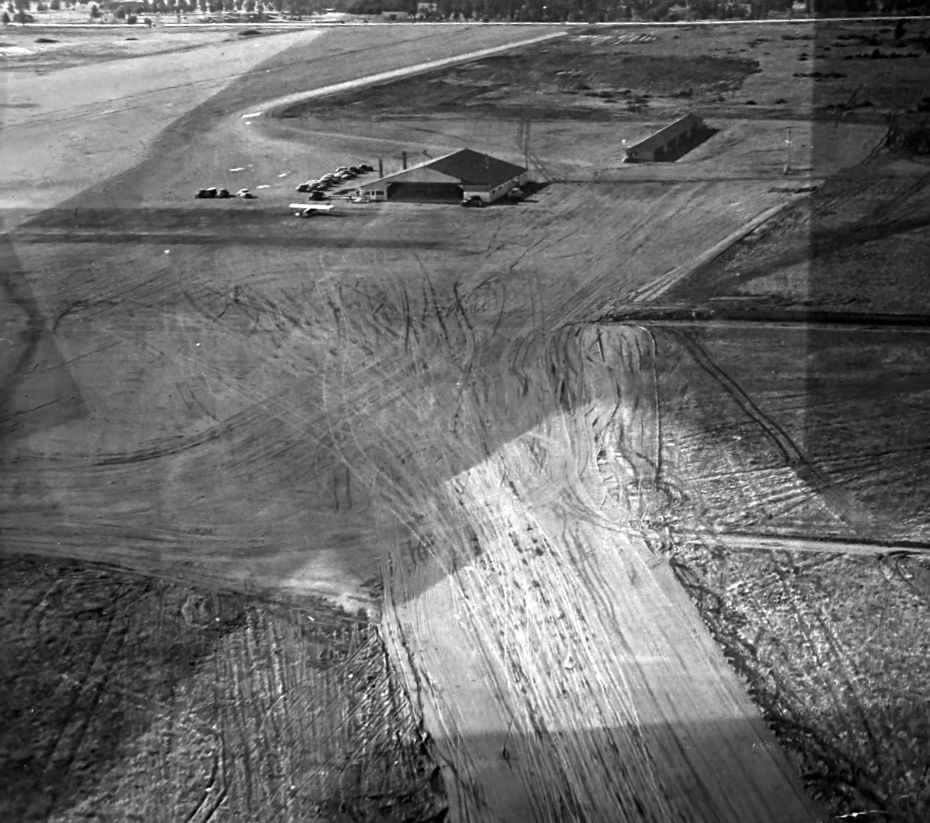
A circa 1940s aerial view looking northwest (courtesy of Dale Fruit) depicted Calkins Air Terminal as having 1 single-engine light plane & 2 hangars next to some unpaved runways.
Dale Fruit recalled, “Claud Calkins was my great uncle.”
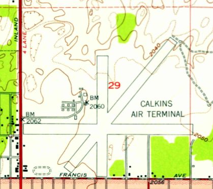
Calkins Air Terminal had evidently gained a 3rd runway at some point between 1948-50,
as the 1950 USGS topo map depicted it as having 3 paved runways, with a complex of buildings to the northwest of the runway intersection.

A circa 1950s brochure (courtesy of John Townsley) depicted future plans for runway lengthening at Calkins Air Terminal.
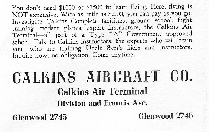
A circa 1950s brochure (courtesy of John Townsley) touted Calkins Aircraft Company.
The last aeronautical chart depiction which has been located of Calkins Air Terminal was on the October 1958 Spokane Sectional Chart.
It depicted Calkins as having a 5,000' unpaved runway.
The last topo map depiction which has been located of Calkins Air Terminal was on the 1958 USGS topo map,
which depicted it in an identical fashion to its depiction on the 1950 USGS topo map.
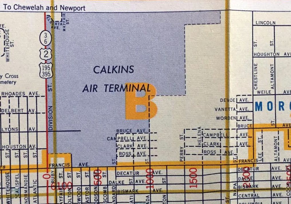
The last depiction which has been located of Calkins Air Terminal was on a 1959 street map (courtesy of Kevin Walsh),
which depicted Calkins as an irregularly-shaped property outline.
According to John Townsley, “The airport seemed to be doing quite well until the latter half of the 1950s.
And then, in the summer of 1959, developers such as Gus Cozza began turning the airfield into urban sprawl.”
Calkins Air Terminal was no longer depicted on the April 1959 Spokane Sectional Chart.
Calkins Air Terminal was no longer depicted on the 1964 USGS topo map,
which instead depicted several streets having been built through the site of the little airport.
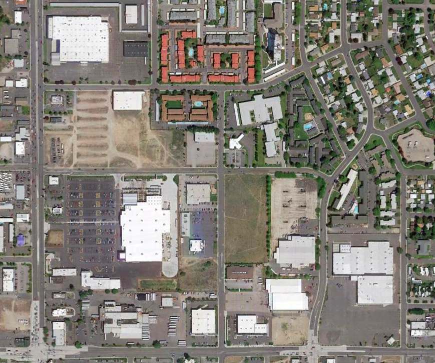
A 7/2/13 aerial showed no trace of Calkins Air Terminal.
Thanks to John Townsley for pointing out this airfield.
____________________________________________________
Northport Airport / James A. Lowry Municipal Airport, Northport, WA
48.925, -117.78 (North of Spokane, WA)
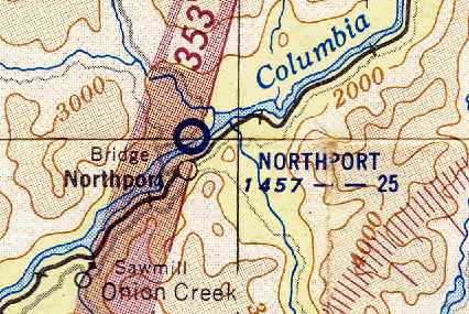
Northport Airport, as depicted in the October 1954 Kootenai Sectional Chart (courtesy of Chris Kennedy).
According to David Field, “A Civil Aeronautics Administration Site Report dated 10/21/48
recommended the site for development of a Class I airport.
The preliminary estimated cost was $14,424, including 124 acres of land for $1,000.”
No airfield was yet depicted at this site on the March 1950 Kootenai Sectional Chart.
According to David Field, “The airport, with a 2,500' x 300’ graded strip was constructed in 1950.
A planned airport inspection in 1952 was not conducted
because the inspector 'couldn’t land due to cattle on the runway'.”
The earliest depiction of the field which has been located
was on the October 1954 Kootenai Sectional Chart (courtesy of Chris Kennedy).
It depicted Northport Airport as having a 2,500' unpaved runway.
According to a historical plaque at the site, it was dedicated as James A. Lowry Municipal Airport in 1955.
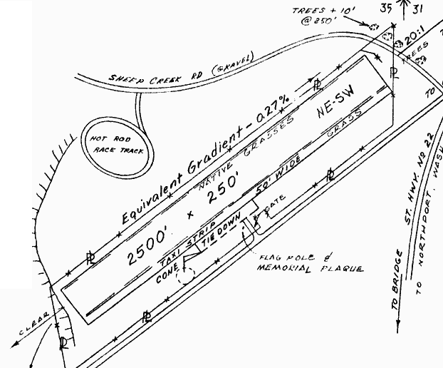
The 1963 WA Airport Directory (courtesy of Ron Dupas) depicted James A. Lowry Municipal Airport as having a single 2,500' soil northeast/southwest runway.
A tie-down area was depicted along the southeast side of the runway, but there were no buildings depicted.
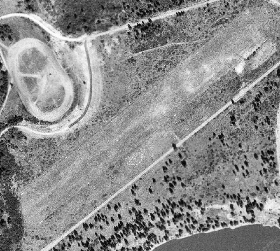
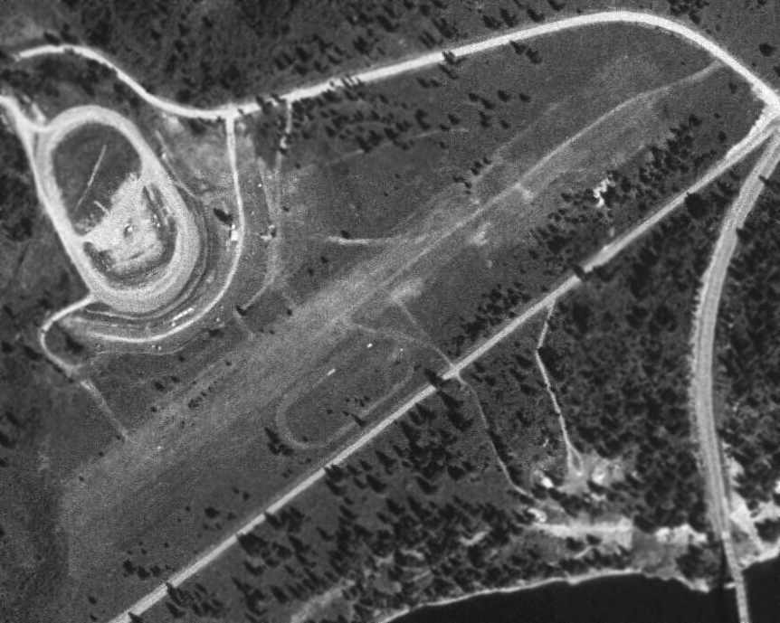
The earliest photo which has been located of James A. Lowry Municipal Airport was an 8/18/65 USGS aerial view.
It depicted Lowry as having a single northeast/southwest unpaved runway.
There were no buildings or aircraft visible on the field.

An aerial view looking north at the James A. Lowry Municipal Airport,
from the 1971 WA State Airport Directory (courtesy of Chris Kennedy).
The directory described James A. Lowry Municipal Airport as having a single 2,500' soil Runway 4/22.
The airport offered no services, and the manager was listed as Robert Weilep.
The last aeronautical chart depiction which has been located of Lowry Airport was on the February 1971 Kootenai Sectional Chart,
which depicted Lowry Airport as having a 2,500' unpaved runway.
James A. Lowry Municipal Airport still listed in the 1976 AOPA Airport Directory (according to Chris Kennedy),
but as a private airport (which appears to be a contradiction for a "Municipal" Airport - ?).
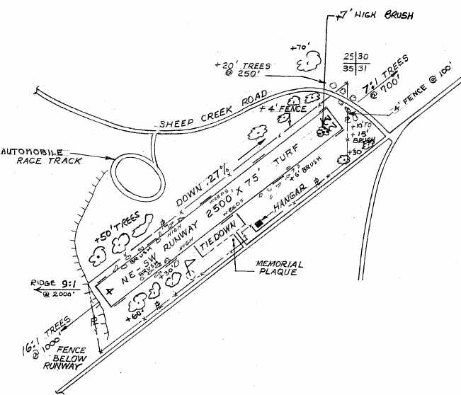
The 9/29/76 FAA Airport Inspection Report (courtesy of David Field) depicted the James A. Lowry Municipal Airport as having a single 2,500' turf Runway 4/22,
with a tiedown area & a single hangar on the southeast side.
The airport property was said to consist of 30 acres, owned by the Town of Northport, and the Manager was listed as R. Norberg.
The field was said to have only 1 resident aircraft.
The 1982 USGS topo map still depicted the "Lowry Landing Strip".
According to David Field (from the FAA's Airport Inspection File), “The airport was closed by the City on 10/30/82.”
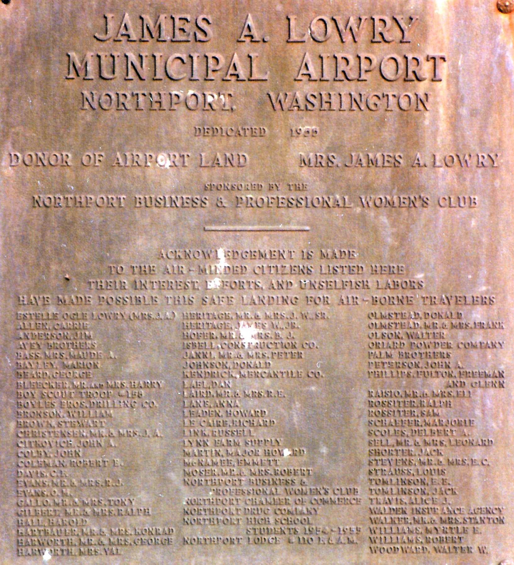
An early 1980s photo by Mathew Hutchings of the James A. Lowry Municipal Airport historical plaque on a granite block.
Lowry Municipal Airport was no longer depicted at all on the 1998 World Aeronautical Chart.
As seen in the 1998 USGS aerial photo, Lowry Municipal's former runway remained intact.
There did not appear to be any buildings or other aviation facilities at the airfield.
Jim Scott reported in 2004, "As the State Airport Maintenance Manager for Washington State
I am always on the lookout for abandoned strips that can be re-opened.
I have been working on a plan for the Northport site, formerly James A. Lowery Municipal,
and hope to make a pitch to the State and the town later this year to open the airport again.
The land the airport sits on was deeded to the city in perpetuity for use as an airport only
and the city, until I came along, has no idea where to start the process."
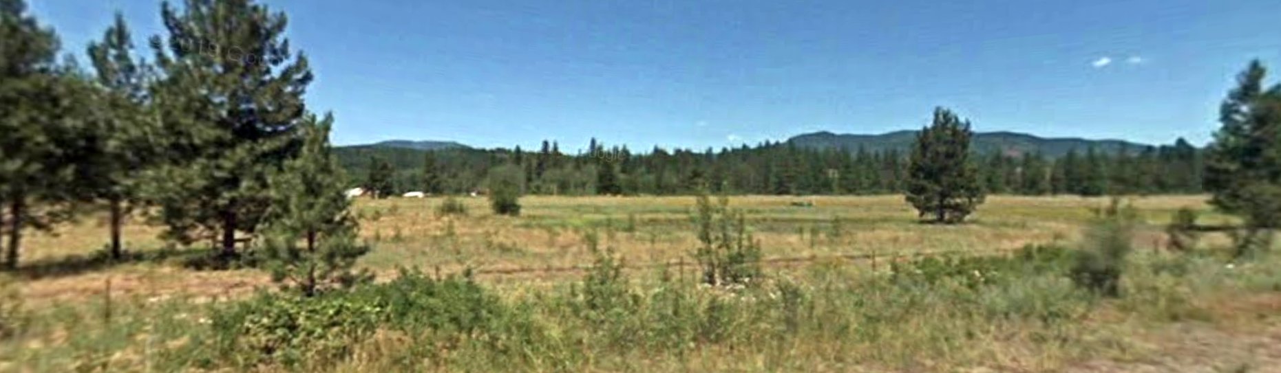
A 2009 photo looking north at the Lowry Municipal Airport site.
Mathew Hutchings reported in 2023 that the Lowry Municipal Airport historical plaque which he photographed in the early 1980s “has since been removed.”
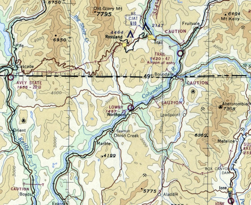
Lowry Municipal Airport is located west of the intersection of Route 25 & Flat Creek Road,
directly across the Columbia River from the town of Northport.
____________________________________________________
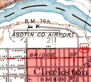
Clarkston Airport / Asotin County Airport, Clarkston, WA
46.425, -117.06 (South of Spokane, WA)
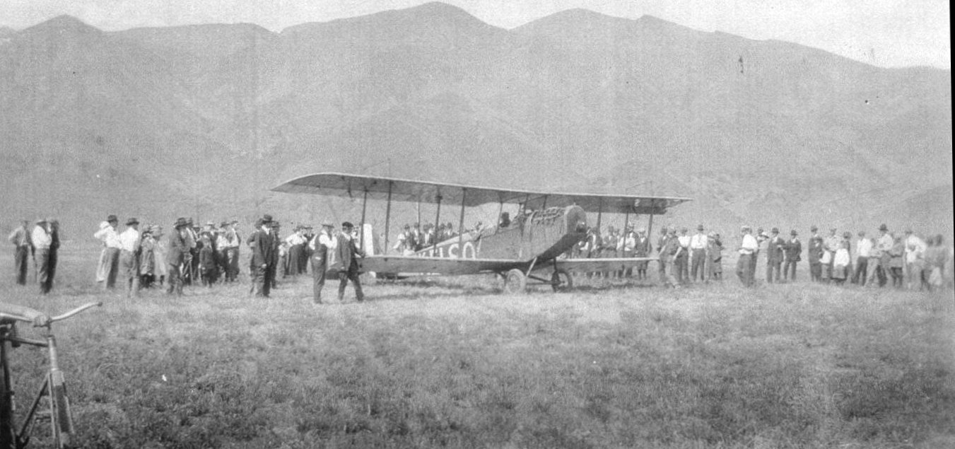
A circa 1915-24 photo of a crowd of spectators around a Curtiss Jenny at the Clarkston Airport (courtesy of Lee Corbin).
The earliest depiction which has been located of this airfield was a circa 1915-24 photo of a crowd of spectators around a Curtiss Jenny at the “Clarkston Airport” (courtesy of Lee Corbin).
Lee Corbin observed, “Based on the mountains in the background, the airfield appears to be in the same location (or close to) where the Asotin County Airport was eventually constructed.”
Asotin County Airport “was built in 1938 by Asotin County & the City of Clarkston”, according to Clarkston resident Steve Smith.
Steve recalled, “When I was a little boy I would go there all the time,
my dad would take me there when he went to the dump (the dump was right next to the airport).
The only operator was Bert Zimmerly. Burt's operation was called Zimmerly Air Transport.
They did training & maintenance. And he also had a small airline, hence the name Zimmerly Air Transport.”
The earliest aerial view which has been located of Asotin County Airport was a 1943 aerial photo.
It depicted Asotin County Airport as having an unpaved east/west runway, with 2 hangars on the north side.
The Asotin County Airport was not listed in the April 1944 US Army/Navy Directory of Airfields (courtesy of Ken Mercer).
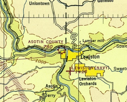
The earliest aeronautical chart depiction which has been located of Asotin County Airport was on the November 1944 Spokane Sectional Chart (courtesy of Ron Plante).
It depicted Asotin County as a commercial/municipal airport.
The 1945 USGS topo map depicted Asotin County Airport as having a single east/west runway,
with a few small buildings along the north side of the runway.
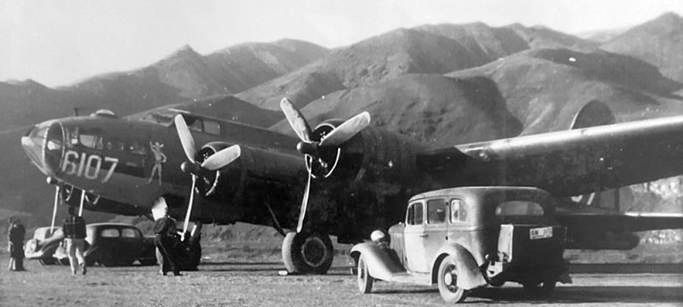
The earliest photo which is available of the Asotin County Airport was a November 1945 photo (courtesy of Stewart Lanham) of Boeing B-17F 42-6107.

The earliest aerial view which is available of the Asotin County Airport
was an undated aerial view looking north from the 1945 AAF Airfield Directory (courtesy of Scott Murdock).
The directory described Asotin County Airport as a 70 acre rectangular property having a single 3,400' east/west gravel runway.
The field was said to have a single 200' x 80' wood hangar, and a 2nd building was visible on the north side of the runway.
The airport was said to be owned by Asotin County, and operated by private interests.
According to Steve Smith, Asotin County Airport operator Burt Zimmerly
“was killed after the war in an accident in bad weather between Spokane & Clarkston.
The transport business was sold to some people in Boise & was called Empire airlines
(no relation to the Empire airlines of today that operates out of Cour d'lene Idaho).”
A 1955 aerial photo depicted 3 planes parked outside the hangars at Asotin County Airport.
Dennis Johnson recalled, “Asotin County... that was the place I first learned to fly.
I remember several hangars (this would have been in 1959).
There was a complete Ford Tri-motor kept alongside one of the hangars.
I flew in & out of there all through high school.”
According to Steve Smith, a 1950 windstorm blew the roof off the original hangar
but the small control tower survived.
Steve recalled, “I remember seeing some great old airplanes there... a P-51, TBM, B-25 just to name a few.”
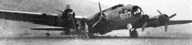
A circa 1950 photo (courtesy of Stewart Lanham) of Boeing B-17F 42-6107 at Asotin County Airport.
A 1961 aerial photo depicted 5 planes parked outside the hangars at Asotin County Airport.
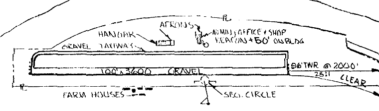
The 1963 WA Airport Directory (courtesy of Ron Dupas)
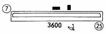
depicted Asotin County Airport as having a single 3,600' gravel east/west runway.
A hangar, administration office, and shop were depicted along the north side of the runway.
According to Steve Smith, “The control tower... somone removed it in the late 1960s
and in was used as a childrens playhouse in Lewiston.”
Dennis Johnson recalled, “Viet Nam interrupted my life for a few years, and the next time I went back -
the hangars were really in a sad state, and the venerable TriMotor was long gone.”
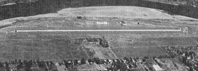
A 1970 aerial photo showed Asotin County Airport remained intact, but there were no planes visible parked outside.
An undated aerial view looking north at the Asotin County Airport, from the 1971 WA State Airport Directory (courtesy of Chris Kennedy).
The directory depicted Asotin County Airport as having a single 4,000' gravel Runway 7/25,
and several buildings (hangars?) were depicted on the north & south sides of the runway.
The manager was listed as Bill Behrens.
Asotin County's runway was apparently paved (but somewhat shortened) within the next year,
as the 1972 Flight Guide (courtesy of Chris Kennedy)
depicted the field as having a single 3,600' paved Runway 7/25,
with a parallel taxiway along the north side.
Two buildings were depicted along the north side of the taxiway.
According to Steve Smith, “The airport closed in the early 1970s.
The maintenance part which was renamed Hillcreast Aircraft operated jointly at Clarkston & Lewiston ID (across the river)
for many years during the 1950s & 1960s.
In the late 1960s The Army Corps of Engineers started building dams along the Snake River
for slack water navigation to the Pacific Ocean for barges that would haul grain & logs overseas.
Asotin County & the city of Clarkston thought they should be in on this action so guess which site they chose?
Yep you guessed it!
They closed the runway but kept the hangars open for awhile (Hillcreast was doing mostly helicopter stuff).”
Asotin County Airport was closed before 1976,
as it was no longer listed in the 1976 AOPA Airport Directory (according to Chris Kennedy).
The 1981 USGS topo map still depicted the former runway, but labeled it simply "Airfield".
According to Steve Smith, “The runway was 3,600' long by 100' wide, gravel, and at one point was lighted.
In about 1983 I was walking along what used to be part of the old runway & found an old runway light!”
A 1998 USGS aerial photo showed several buildings & streets had been built over Asotin County Airport's former runway.
But the 2 circa 1938-43 hangars remained standing on the north side.
Clarkston native Brad Clark reported in 2005, “One of the hangars & I think the original FBO / administration offices still stand,
as they are occupied by an antique store.
The front desk of the store has a lot of memorabilia about the airfield.”
Steve Smith reported in 2007, “The big hangar was sold to Poe Aspalt & is still there today.
The small original hangar sat empty for years,
then was bought by the Day family of Clarlston & they operate an Antque Mall there.
I was home last weekend & went there.
They have some pictures on the wall & a nice book with alot of interesting pictures in it.”
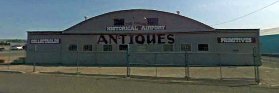
A circa 2010-2018 photo (courtesy of Lee Corbin) of the former Asotin County Airport hangar, reused by a business is known as “The Hangar Mall”.
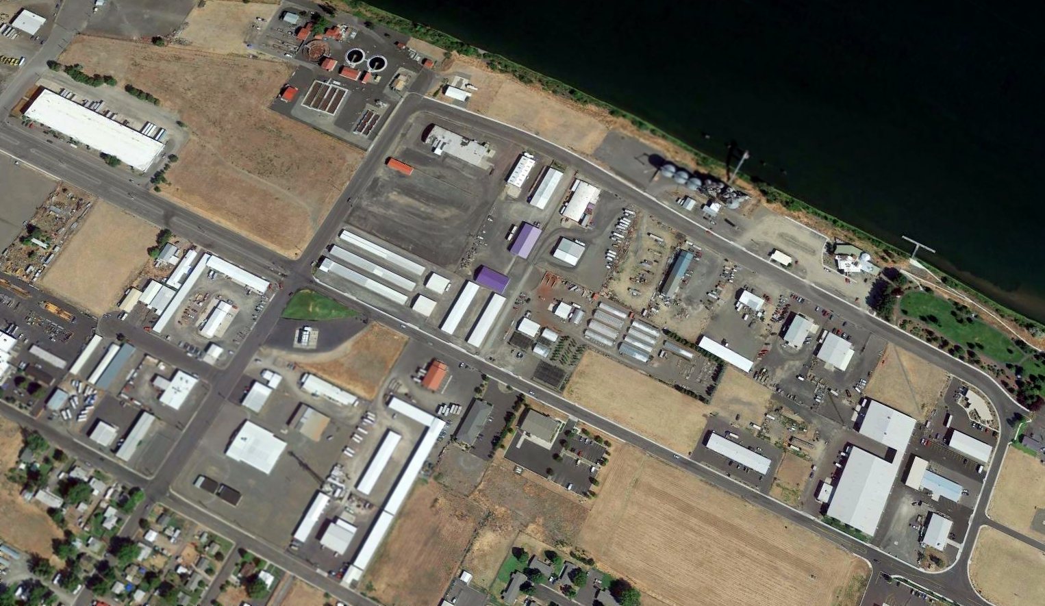
A 2015 aerial view looking northwest showed several buildings & streets covering the former Asotin County Airport runway,
but the 2 circa 1938-43 hangars remained standing on the north side.
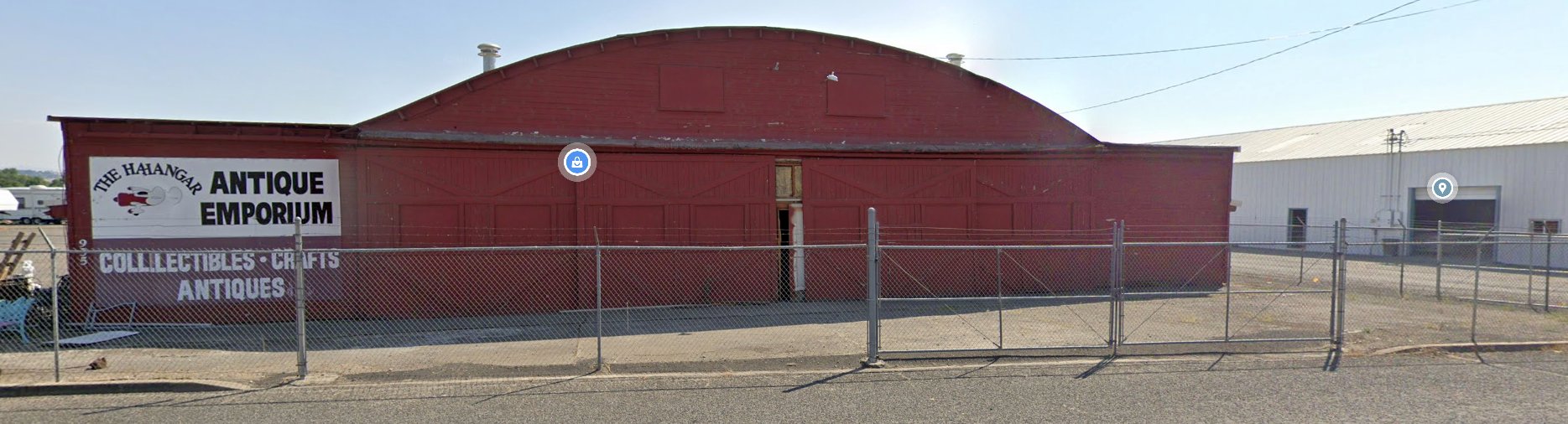
A 2019 photo looking south at the former Asotin County Airport hangar, reused as “The Hangar Antique Empoorium”.
Asotin County Airport is located at the intersection of Port Drive & 13th Street.
____________________________________________________
48.886, -118.61 (Northwest of Spokane, WA)
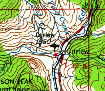
Curlew Airport, depicted on the 1958 USGS topo map.
This general aviation airport was located only 6 miles south of the Canadian border.
Curlew Airport was evidently built at some point in 1958,
as it was not depicted on the 1951 USGS topo map or the October 1958 Kootenai Sectional Chart.
The earliest depiction which has been located of Curlew Airport was on the 1958 USGS topo map.
The earliest aeronautical chart depiction which has been located of Curlew Airport was on the October 1959 Kootenai Sectional Chart.
It depicted Curles Airport as having a 2,800' unpaved runway.
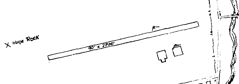
The 1963 WA Airport Directory (courtesy of Ron Dupas)
depicted Curlew Airport as having a single 2,700' east-northeast/west-southwest runway,
along with 2 hangars on the southeast side of the field.
A "huge rock" was also depicted just northwest of the runway.
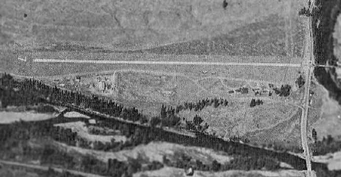
An aerial view looking north at Curlew Airport, from the 1971 WA State Airport Directory (courtesy of Chris Kennedy).
The directory depicted Curlew Airport as having a single 2,000' dirt Runway 7/25, and said that limited services were available, including fuel.
The manager was listed as Carl Lindsey.
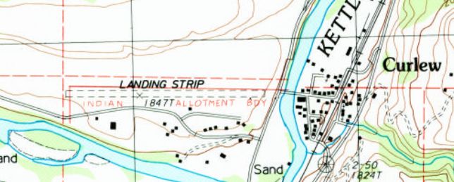
The 1988 USGS topo map depicted Curlew as a single unpaved east/west runway, labeled simply as “Landing Strip”.
At some point between 1971-93, Curlew's runway had been paved & lengthened,
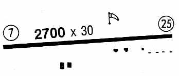
as the 1993 Flight Guide (courtesy of Chris Kennedy) depicted the field as having a single 2,700' paved Runway 7/25.
Five small buildings were depicted along the south side of the runway.
However, although the airport's infrastructure had been expanded,
it was apparently in a state of decline, as it was listed as unattended, and to be used at "own risk".
A 1995 USGS aerial view looking northwest showed one T-hangar was still standing on the south side of Curlew's runway.
Curlew Airport was apparently closed (for reasons unknown) at some point between 1993-98,
as it was no longer depicted on the 1998 World Aeronautical Chart.
A 1998 aerial view showed Curlew's runway & its T-hangar remained intact.
A 2003 aerial view showed construction had covered the western portion of the Curlew Airport runway,
and the T-hangar had been removed at some point between 1998-2003.
A 2013 aerial view looking northwest showed no trace recognizable of Curlew Airport.
Curlew Airport is located northeast of the intersection of Customs Road & Curlew Airport Road, appropriately enough.
____________________________________________________
46.237, -118.83 (Southwest of Spokane, WA)
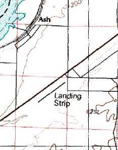
Ash Airport was depicted simply as “Landing Strip” on the 1976 USGS topo map.
The name & history of this small airfield is unknown.
It was evidently built at some point between 1964-76, as it was not depicted on the 1948/50/55/60/65 Spokane Sectional Charts,
a 1957 aerial photo, or the 1964 USGS topo map.
The earliest depiction of the field which has been located was on the 1976 USGS topo map,
which depicted a single northeast/southwest runway, labeled simply as "Landing Strip".
The earliest photo which has been located of the Ash Airport was a 1982 aerial view.
It depicted Ash as consisting of a single 3,800' paved northeast/southwest runway,
and a small paved ramp with several small buildings at the northeast end of the runway.

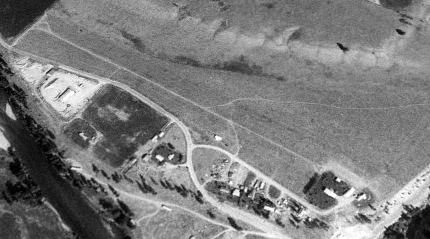
The earliest photo which is available of the Ash Airport was a 7/1/96 USGS aerial view looking south.
It depicted Ash as consisting of a single 3,800' paved northeast/southwest runway, and a small paved ramp with several small buildings at the northeast end of the runway.
Ash Airport was not depicted on the 1998 World Aeronautical Chart.
There was no airfield listed at this location in the 2000 Airport/Facility Directory.
Anson Statema (a CFII in Pasco, WA) reported in 2004, "Ash Airport is an interesting one; I have never seen an aircraft there.
I was told by a local that the runway was excess pavement, and was put down there when someone asked for a paved landing strip at the same time the excess occurred.
I can't verify that, but as I said I've never seen an aircraft parked there. I heard indirectly that certain charter operators drop off passengers there. It certainly isn't an active airport at this point."

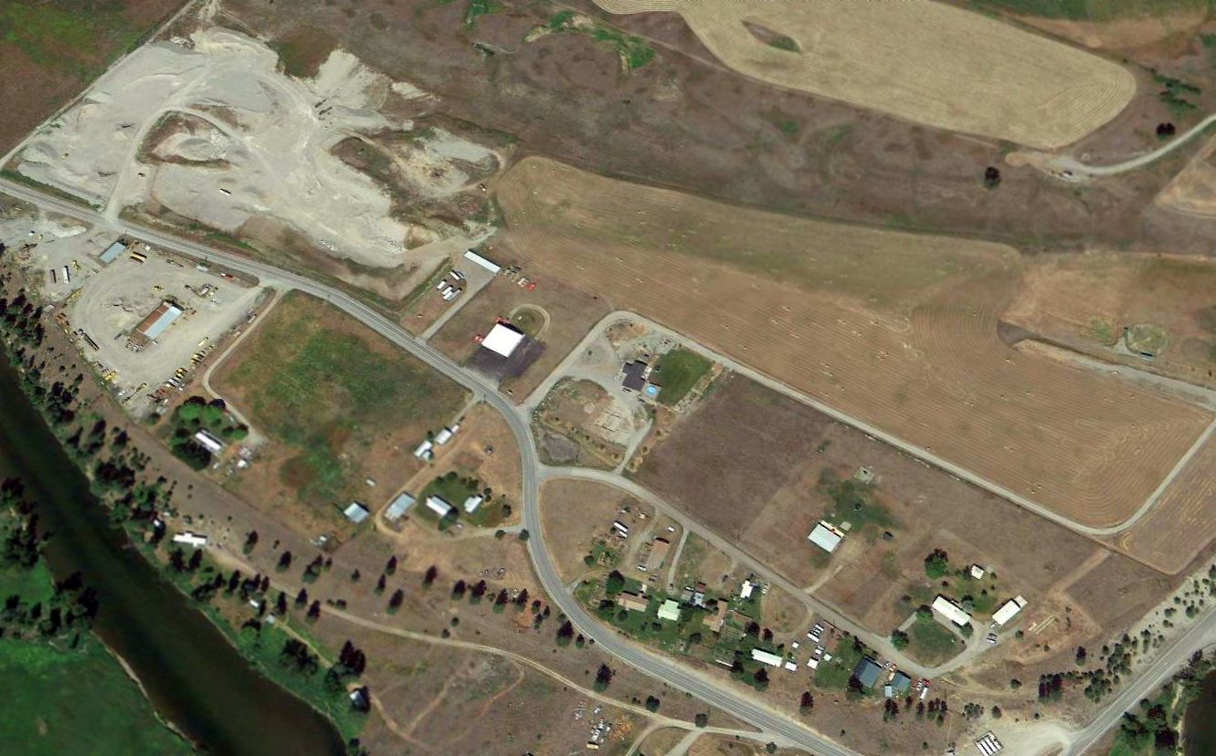
A 2023 aerial view looking south showed the Ash runway to remain completely intact.
Ash Airport is located south of Route 124, 13 miles east of Pasco, WA.
____________________________________________________
Or if you prefer to contact me directly concerning a contribution (for a mailing address to send a check),
please contact me at: paulandterryfreeman@gmail.com
If you enjoy this web site, please support it with a financial contribution.
____________________________________________________
This site covers airfields in all 50 states.