Abandoned & Little-Known Airfields: Wyoming
© 2002, © 2026 by Paul Freeman. Revised 2/15/26.
This site covers airfields in all 50 states: Click here for the site's main menu.
____________________________________________________
Please consider a financial contribution to support the continued growth & operation of this site.
American Legion Airport / Douglas Intermediate Field / Douglas Municipal Airport / (Original) Converse County Airport (revised 11/9/16)
Casper Central Airport (added 12/30/17) - Evanston Flying Club Airfield / (Original) Evanston Municipal Airport (revised 8/19/22) - (Original) Hot Springs County Thermopolis Airport (revised 12/3/25)
Igo Airfield (revised 7/20/24) - (Original) Rock Springs Airport (revised 5/12/20) - Ten Sleep Airport (added 6/8/21) - Wamsutter Airport (revised 1/6/19) - Wardwell Field (revised 2/15/26)
____________________________________________________
(Original) Hot Springs County Thermopolis Airport (THP), Thermopolis, WY
43.664, -108.209 (Northwest of Casper, WY)
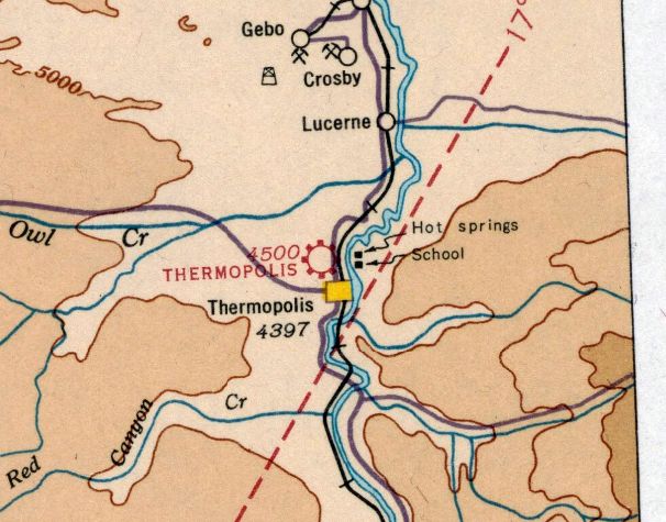
Thermompolis Airport, as depicted on the June 1936 Cheyenne Sectional Chart.
The original Thermopolis Airport was located adjacent to the northwest side of the town.
The date of construction of the original Thermopolis Airport has not been determined.
The earliest depiction which has been located of Thermopolis Airport was on the June 1936 Cheyenne Sectional Chart.
It depicted Thermopolis Airport as a commercial/municipal airport.

The earliest photo which has been located of Thermopolis Airport was a 1954 aerial view.
It depicted a single unpaved northeast/southwest runway & small building on the southeast side.
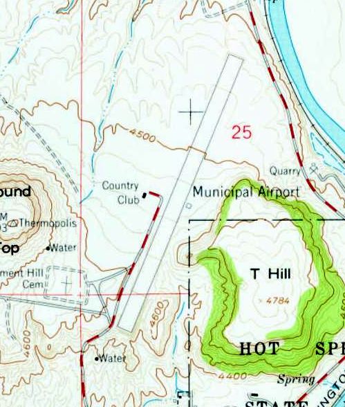
The earliest topo map depiction which has been located of Thermopolis Airport was on the 1960 USGS topo map.
It depicted the “Municipal Airport” as having a single paved northeast/southwest runway, with 1 small building on the east side.
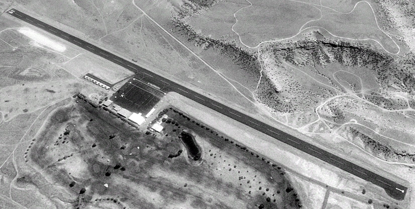
A 1994 aerial view looking east depicted Thermopolis Airport as having a single asphalt Runway 1/19, with a ramp, several hangars, and what appeared to be a Learjet on the west side.
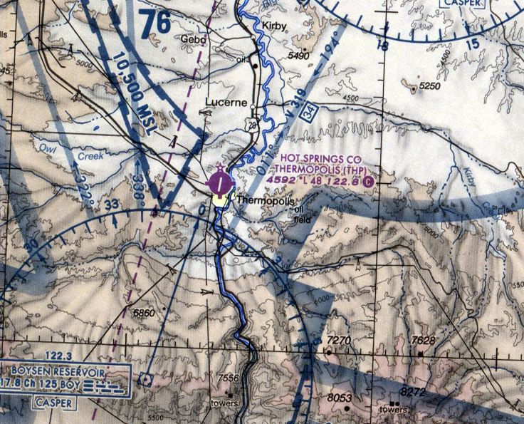
The last aeronautical chart depiction which has been located of the original Hot Springs County Thermopolis Airport was on the July 2009 Cheyenne Sectional Chart.
It depicted Thermopolis Airport as having a single 4,800' paved runway.
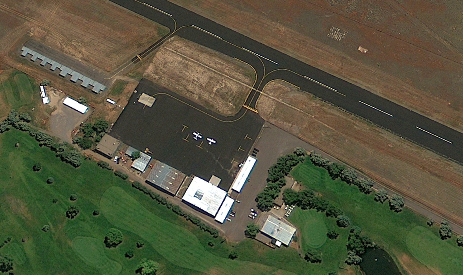
The last photo which has been located showing aircraft at the original Hot Springs County Thermopolis Airport was a 2010 aerial view looking east, which showed 2 light single-engine planes on the ramp.
A new Thermopolis Hot Springs County Airport (HSG) was opened in 2015 about 5 miles to the northwest,
and presumably the original Thermopolis Airport was closed at that point.
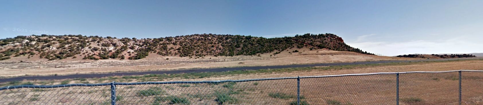
The new airport has clear approaches, in contrast to the hills which straddle the original airport.
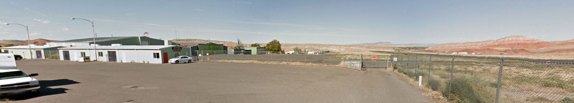
A 2015 photo looking north showed the hangars & ramp of the original Hot Springs County Thermopolis Airport, devoid of aircraft, evidently shortly after its closure.
A 2015 photo looking north showed the hangars & ramp of the original Hot Springs County Thermopolis Airport, devoid of aircraft, evidently shortly after its closure.
The original Thermopolis Airport was no longer depicted on the July 2017 Cheyenne Sectional Chart.
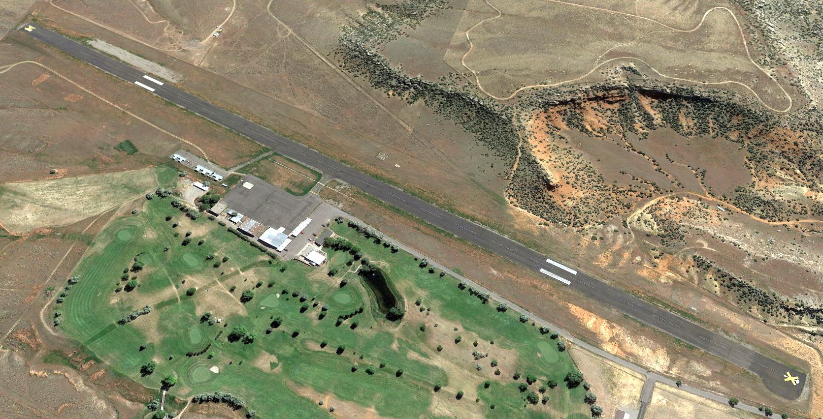
A 2017 aerial view looking east showed the original Hot Springs County Thermopolis Airport remained intact, though with the runway marked with 2 yellow X closed-runway symbols.
Thanks to Steven Pouliot for pointing out this airfield.
____________________________________________________
Ten Sleep Airport (50U), Ten Sleep, WY
44.023, -107.438 (Northwest of Casper, WY)
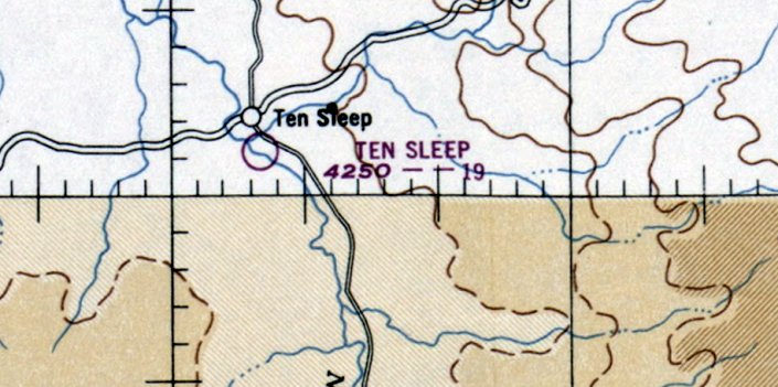
Ten Sleep Airport, as depicted on the April 1949 Sectional Chart (courtesy of Jonathan Westerling).
Photo of the airport while in use has not been located.
Jonathan Westerling reported, “The 300 or so residents of Ten Sleep gained their own municipal airport just after WW2 in June of 1948.
Listed as a 'New Airport' in that month's Airman's Guide, initially the field was just 1,900' long.”
The earliest depiction which has been located of Ten Sleep Airport was on the April 1949 Sectional Chart (courtesy of Jonathan Westerling).
It depicted Ten Sleep Airport as having a 1,900' unpaved runway.
According to a 1/15/16 Northern Wyoming News story (courtesy of Jonathan Westerling), the Ten Sleep Airport was once the home to crop dusting operations & private aircraft owned by local ranchers.
Located on 361 acres owned by Brubaker Ranch, the airfield experienced its heyday from the 1940s-70s,
when station-to-station private air travel was popular in Wyoming, and private aircraft ownership was more popular as a hobby."
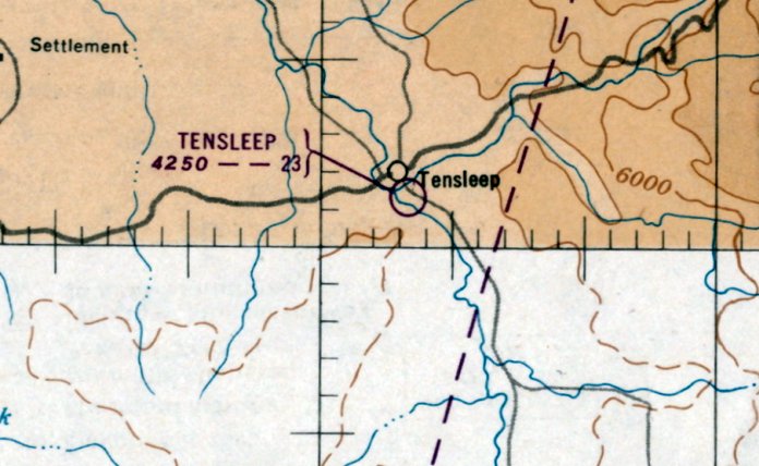
The April 1951 Sectional Chart (courtesy of Jonathan Westerling) showed that the Ten Sleep Airport runway had been lengthened slightly to 2,300'.
The earliest photo which has been located of Ten Sleep Airport was a 1954 aerial view.
It depicted Ten Sleep Airport as a single unpaved northwest/southeast runway, with 2 small buildings on the east side.
There were no aircraft visible on the field.
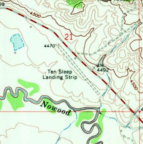
The 1967 UGS topo map depicted “Ten Sleep Landing Strip” as a single unpaved northwest/southeast runway, with 1 small building on the east side.
Jonathan Westerling reported that Ten Sleep Airport's runway remained in an unchanged configuration throughout the 1960s,
“but was improved in 1970 with a longer runway on a slightly different heading than the first.
The back of the 1970 Rapid City Sectional lists the new runway at Ten Sleep to be turf & 3,000' long.
Curiously however, the original runway continued to be listed along with the new longer runway, despite it being just one compass heading difference from the newer, longer one.”
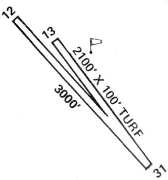
The 1974 Flight Handbook (courtesy of Jonathan Westerling) depicted Ten Sleep Airport as having 2 turf runways, the longest being 3,000' Runway 12/30.
The field was said to be unattended, with no operator.
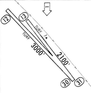
A 1977 Jeppesen directory (courtesy of Jonathan Westerling) depicted Ten Sleep Airport as having 2 turf runways, the longest being 3,000' Runway 12/30.
The field was said to be unattended.
Jonathan Westerling reported, “Both runways continued to be used for almost 15 years, the original shorter runway finally being removed from directories in 1985.”
The last listing which has been located of Ten Sleep Airport was in the 1989 AOPA Airport Directory (courtesy of Jonathan Westerling).
It described Ten Sleep Airport as having a “rough” 3,000' turf Runway 12/30.
The Ten Sleep Airport was evidently closed (for reasons unknown) at some point between 1989-90,
as it was no longer depicted on the 1990 Wyoming State Aeronautical Chart (according to Jonathan Westerling) or subsequent directories.
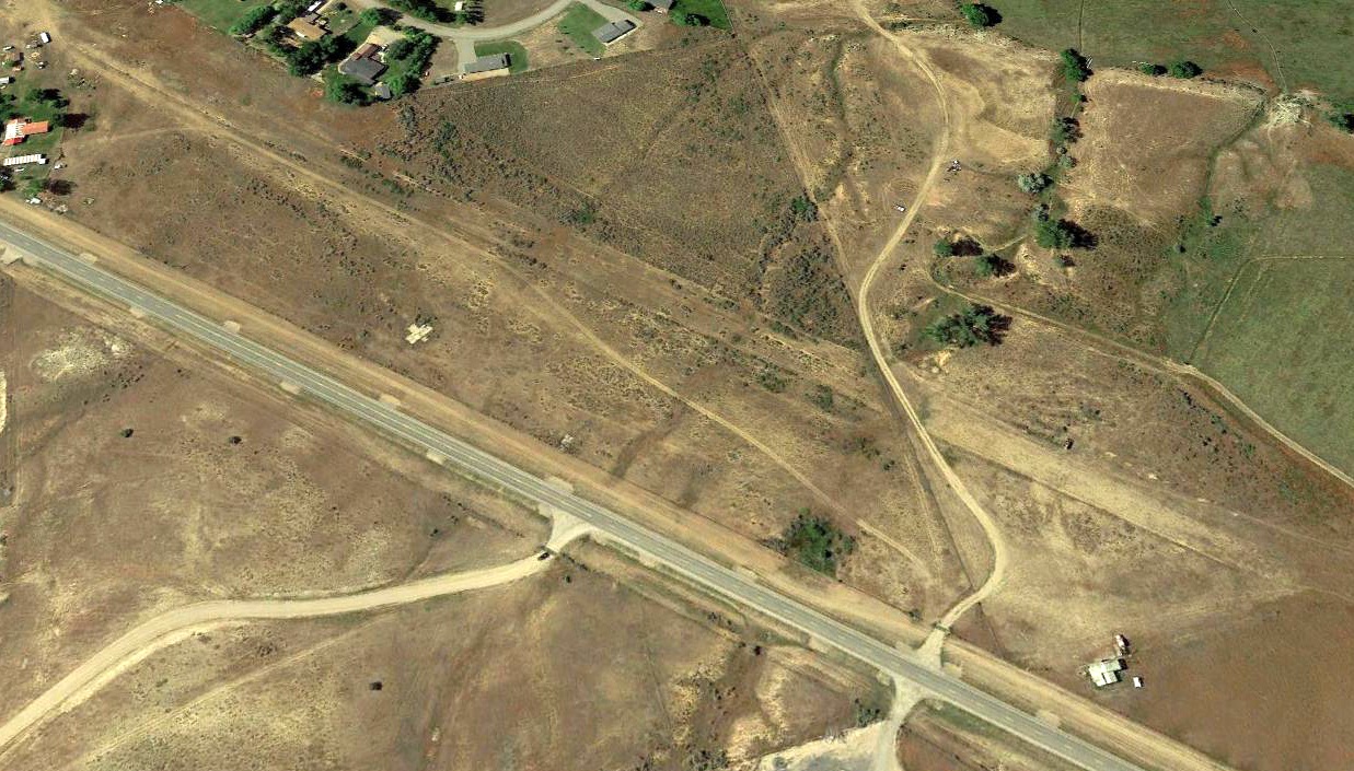
A 2014 aerial view looking south shows a road had been cut through the northern portion of the Ten Sleep Airport runway, but 1 (or possibly 2) small hangars remained on the east & northeast sides.
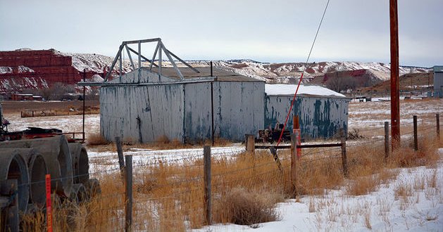
A circa 2016 photo by Marcus Huff (courtesy of the Northern Wyoming News, used with permission) of a remaining abandoned hangar at the site of Ten Sleep Airport.
Thanks to Jonathan Westerling for pointing out this airfield.
____________________________________________________
Casper Central Airport, Evansville, WY
42.863, -106.274 (South of Casper, WY)
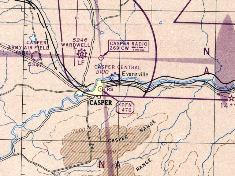
Casper Central Airport, as depicted on the November 1946 Casper Sectional Chart.
This short-lived general aviation airport was evidently established in 1946,
as it was not yet depicted on the May 1946 Casper Sectional Chart.
The earliest depiction which has been located of Casper Central Airport was on the November 1946 Casper Sectional Chart.
It depicted Casper Central Airport as a commercial/municipal airport.
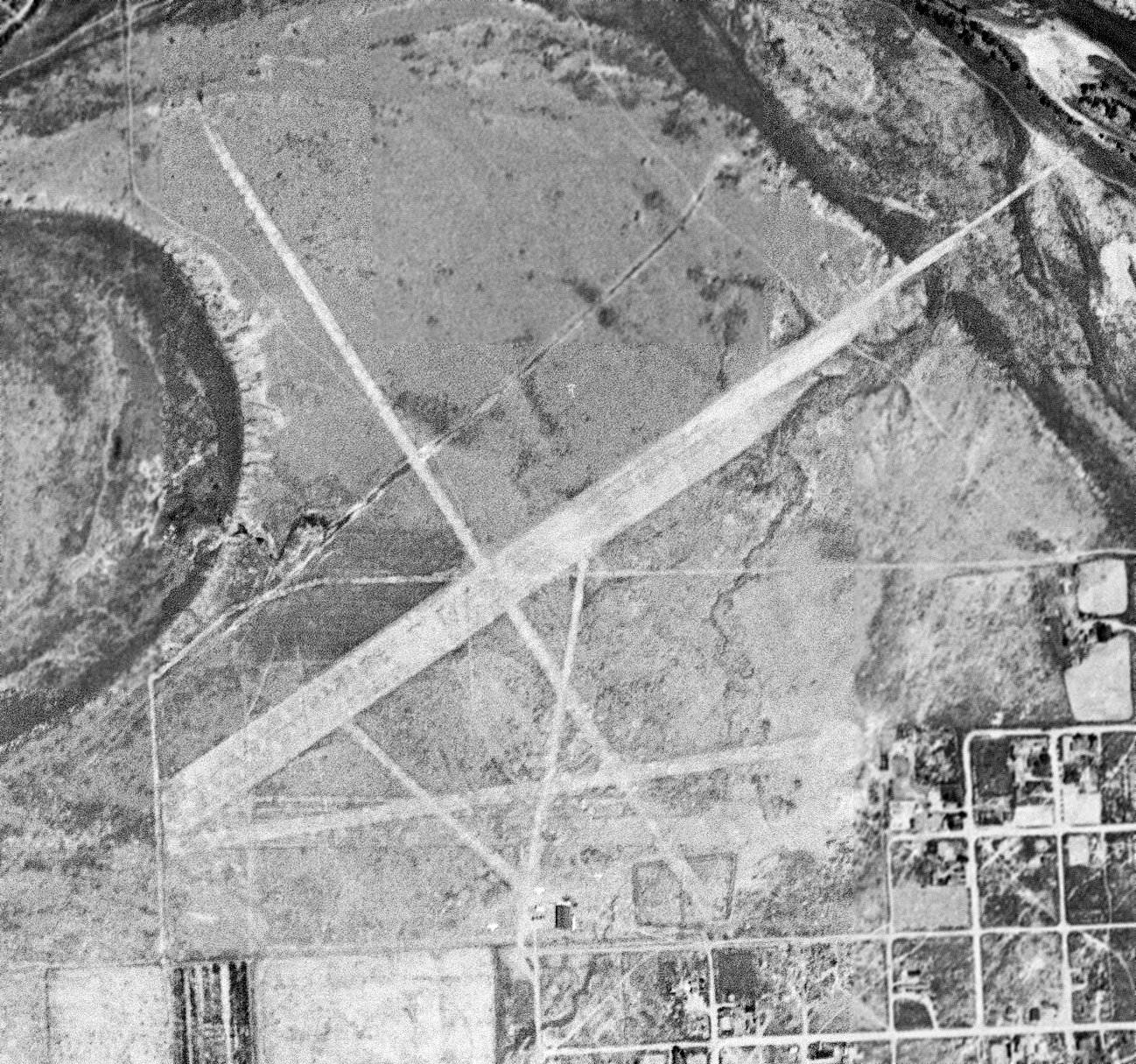
The only photo which has been located of Casper Central Airport was a 6/7/47 USGS aerial view.
It depicted Casper Central Airport as having 3 unpaved runways, and at least 3 light single-engine airplane parked near a small building on the south side.
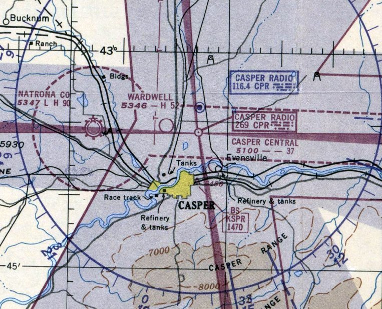
The last aeronautical chart depiction which has been located of Casper Central Airport was on the May 1951 Casper Sectional Chart.
It depicted Casper Central Airport as having a 3,700' unpaved runway.
Casper Central Airport evidently lasted only 5 years, and was closed in 1951,
as it was no longer depicted on the October 1951 Casper Sectional Chart.
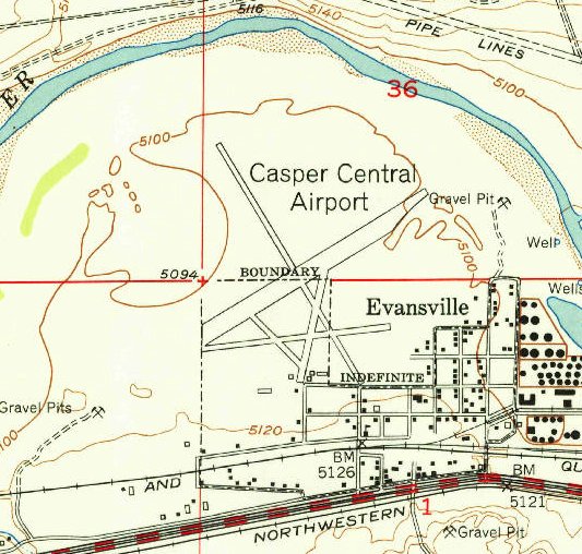
The only topo map depiction which has been located of Casper Central Airport was on the 1952 USGS topo map.
It depicted Casper Central Airport as having 3 runways & several small buildings on the south side.
The 1965 USGS topo map no longer depicted Casper Central Airport, but instead depicted a gravel pit on the northern portion of the property.
A 1971 aerial photo showed the site of Casper Central Airport was being redeveloped with houses.
Alex Price pointed out the irony: “Because those houses HAD to be RIGHT THERE - the adjacent land, untouched to today, just wouldn't suffice!”
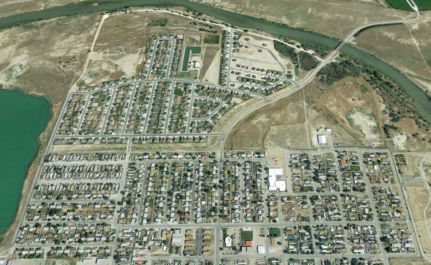
A 2015 aerial view looking north showed no trace of Casper Central Airport.
Thanks to Alex Price for pointing out this airfield.
____________________________________________________
Wamsutter Airport, Wamsutter, WY
41.687, -107.987 (Southwest of Casper, WY)
Wamsutter Airport, as depicted on the July 1942 Cheyenne Sectional Chart.
This airport on the northwest side of the town of Wamsuttter was evidently established at some point between 1940-41,
as it was not yet listed in The Airport Directory Company's 1940 Airport Directory (according to Tim Zukas)
nor depicted on the April 1940 Cheyenne Sectional Chart.
The earliest reference which has been located to the Wamsuttter Airport
as in The Airport Directory Company's 1941 Airport Directory (according to Tim Zukas),
which listed it as a Civil Aeronautics Administration Intermediate Field.
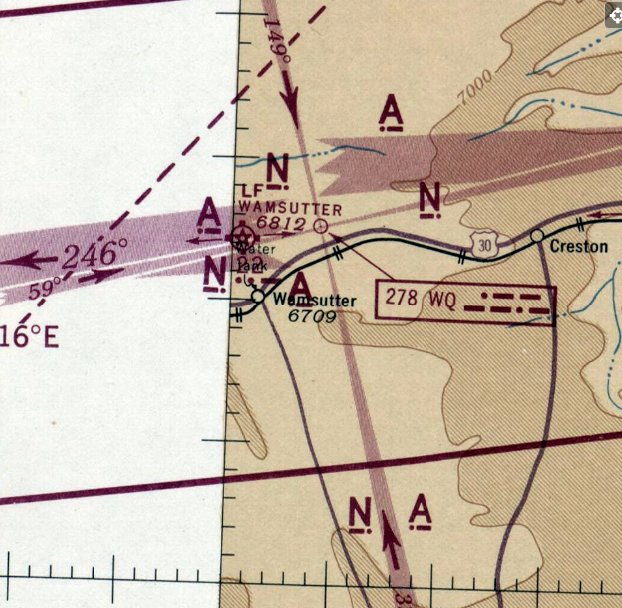
The earliest depiction which has been located of Wamsutter Airport was on the July 1942 Cheyenne Sectional Chart.
It depicted Wamsutter as a commercial/municipal airport, and having Commerce Department Airway Beacon #22.
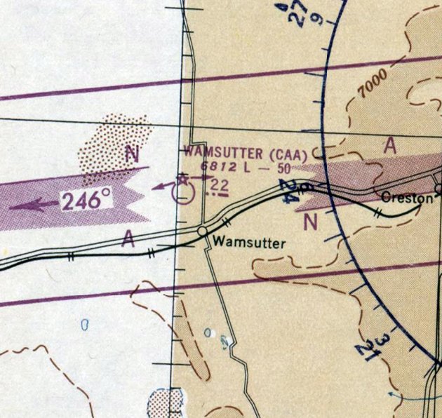
The last aeronautical chart depiction which has been located of Wamsutter Airport was on the April 1950 Cheyenne Sectional Chart.
It depicted Wamsutter as a Civil Aeronautics Administration Airfield having a 5,000' unpaved runway.
Wamsutter Airport was evidently closed (for reasons unknown) in 1950,
as it was no longer depicted on the October 1950 Cheyenne Sectional Chart.
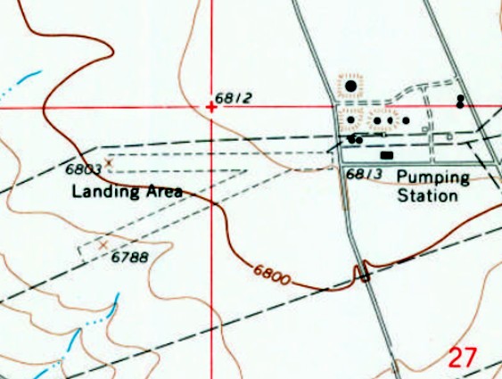
The 1966 USGS topo map depicted Wamsutter Airport as 2 unpaved runways, labeled simply as “Landing Area”.
This may indicate that the airport was closed by that point.
A “Pumping station” was depicted adjacent to the east side, which other maps label as the “Utah Oil Refining Station”.
The 1981 USGS topo map depicted Wamsutter Airport in the same fashion as the 1966 topo map.
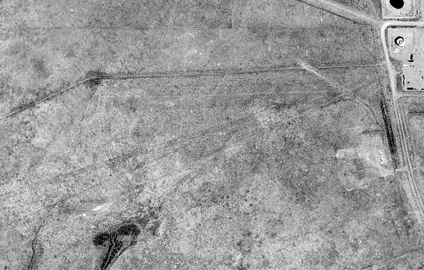
The earliest photo which has been located of Wamsutter Airport was a 1994 USGS aerial view.
The outline of the 2 unpaved runways was barely recognizable.
A 2014 aerial view showed the outline of Wamsutter Airport's 2 unpaved runways was barely recognizable.
The site of Wamsutter Airport is located northwest of the intersection of Kelly Road & Carlton Road.
Thanks to Jason Ward for pointing out this airfield.
____________________________________________________
(Original) Rock Springs Airport, Rock Springs, WY
41.63, -109.24 (Northwest of Cheyenne, WY)
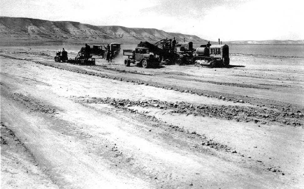
A 1920 photo of the initial clearing for Rock Springs Airport (courtesy of the Sweetwater County Historical Museum, via Curtis Carroll),
looking west toward West Mountain (also known as Table Mountain), a lengthy ridge rising 1,000' above the field.
Curtis Carroll reported, “According to records kept at the Sweetwater County Historical Museum,
construction on the original Rock Springs Municipal Airport began in August, 1920.
The new airport was located north of the city about 5 miles.
Once relay stations & a hangar were established in September, 1920,
the airport was activated as part of the new transcontinental Air Mail Service inaugurated by the Postal Service.
The first field manager was Harvey Mummert, who quickly set up operations then was succeeded by Carl Krebs.”
Curtis continued, “On January 26, 1922, pilot Bob Ellis was attempting a takeoff when he was forced into the side of White Mountain by a downdraft and landed in a large snow drift.
Ellis was unhurt and the airplane was partially disassembled, carefully dragged down the mountain & repaired.”

An undated photo of Rock Springs' hangar from the November 1924 Union Pacific Coal Company magazine
(courtesy of Sweetwacourtesy of the Sweetwater County Historical Museum, via Curtis Carroll).
The original caption read, “Western Terminal Station, Central Division of the Air Mail Service, Rock Springs.
Hangar & radio towers in center, with 500,000,000 candle-power arc light at right.
According to Curtis Carroll, “The airport’s hangar was 100' x 90' with a storage capacity of 5 planes.
Included also in the building was a motor room for the storage & repair of many extra motors, a stock room for extra parts & tools, and a wing repair shop.
The radio station was manned by 2 operators on alternating shifts, and located near the hangar.
This was a similar layout to all terminal landing fields at the time.”
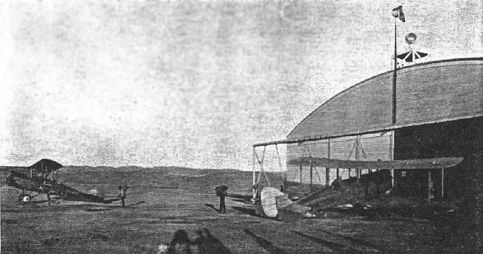
An undated photo of air mail planes in front of Rock Springs' hangar from the November 1924 Union Pacific Coal Company magazine
(courtesy of the Sweetwater County Historical Museum, via Curtis Carroll).
The original caption read, “Transferring the mail from plane just in from Salt Lake to plane ready to depart for Cheyenne.
Pilot H.A. Chandler will soon depart on his routine flight & his little daughter in Cheyenne will wait for the sound of his engine & call to her mother, 'Here comes Daddy.'”
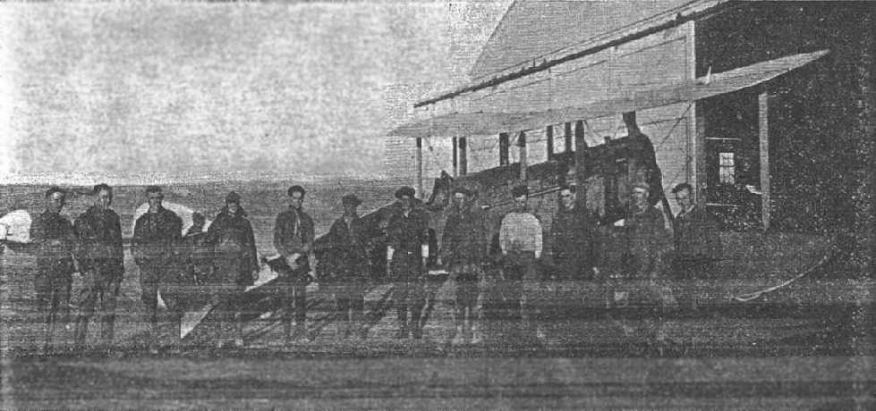
An undated photo of air mail pilots at Rock Springs from the November 1924 Union Pacific Coal Company magazine
(courtesy of the Sweetwater County Historical Museum, via Curtis Carroll).
The original caption read, “Part of the personnel of the Western Terminal Station of the Central Division, Air Mail Service, Rock Springs, WY.”
According to Curtis Carroll, “Edward Maroney took over as Field Manager in the late 1920s.
Maroney had been a rigger & mechanic at the Cheyenne airport as early as 1922.”
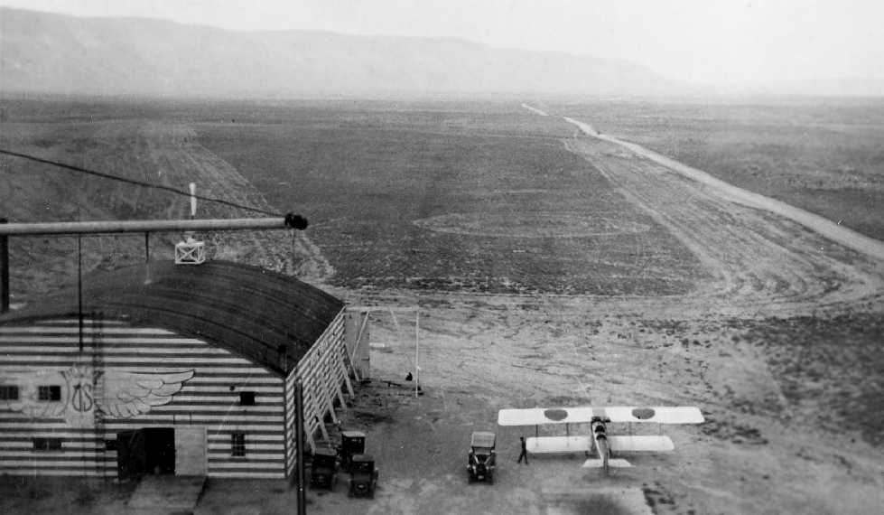
A circa 1924-30 photo (from the Sweetwater County Historic Museum, courtesy of Curtis Carroll).
According to Curtis Carroll, “It’s the same building in the early photos but updated with horizontally stripped paint & Air Mail Iivery.
Important because it shows clearances made for runways & a road orientation that matches the Auto Club map.
It’s after November, 1924, the date of the article that some of the [preceding] photos are from,
and [before] when the new terminal building was dedicated in December, 1930.”
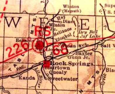
A 1929 Rand McNally Air Trails map of WY showing location of Rock Springs Municipal
and radials leading to Salt Lake & Cheyenne (courtesy of the Sweetwater County Historical Museum, via Curtis Carroll).
The Airport Directory described Rock Springs Airport as being 3,700' x 1,800', at an elevation of 6,400', and listed Boeing Air Transport as the operator.
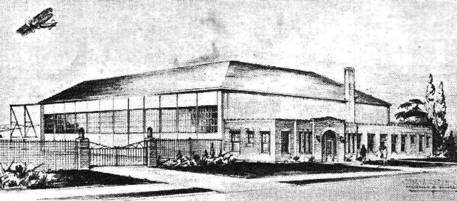
An artists depiction from the December, 1930 Union Pacific Coal Company’s Employees’ Magazine
announcing the dedication of a new $45,000 hangar at Rock Springs (courtesy of the Sweetwater County Historical Museum, via Curtis Carroll).
The new hangar would accommodate 2 18-passenger planes and “is modernly equipped with waiting rooms, offices, mechanic’s rooms, and a radio station”.
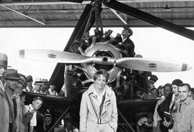
A June 1931 photo of world-renowned aviatrix Amelia Earhart visiting Rock Springs
in a gyro-plane sponsored by Beechnut Chewing Tobacco (courtesy of the Sweetwater County Historical Museum, via Curtis Carroll).
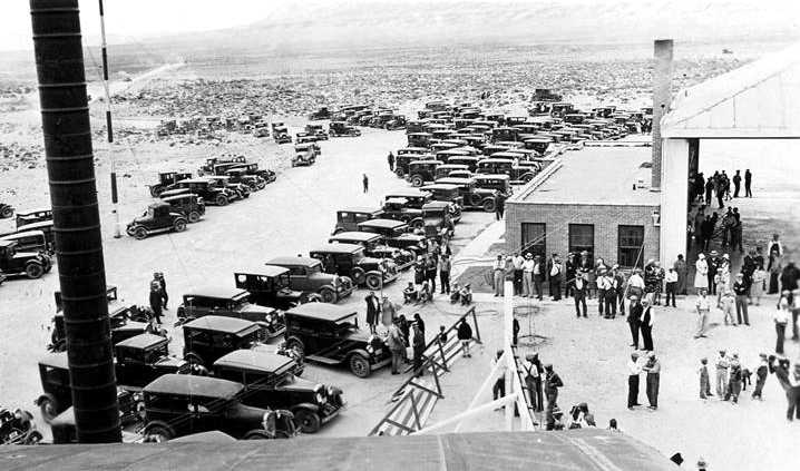
A June 1931 photo of Amelia Earhart's visit to Rock Springs (courtesy of the Sweetwater County Historical Museum, via Curtis Carroll).
According to Curtis Carroll, “The whole town came out to greet her.”
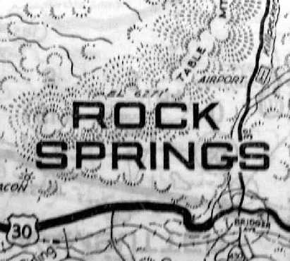
The 1933 HM Gousha WY Road Map depicted Rock Springs Airport by a white star symbol (courtesy of Curtis Carroll).

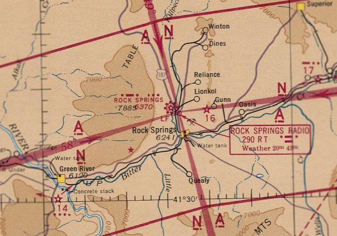
The earliest aeronautical chart depiction which has been located of Rock Springs Airport was on the December 1935 Salt Lake City Sectional Chart.
According to Curtis Carroll, “By 1934, Maroney left & Raymond Aho, a Rock Springs native, was appointed District Manager.
He had been a mechanic at the airport as early as 1930.
In the late 1930s, a site for a new airport with better approach patterns & fewer obstacles was chosen 8 miles southeast of town.
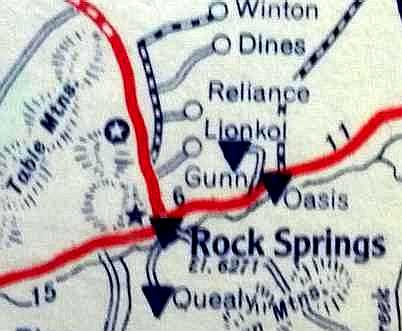
A 1940 Auto Club of Southern CA strip map depicted a more precise location of Rock Springs Airport (courtesy of Curtis Carroll).
The last aeronautical chart depiction which has been located of the original Rock Springs Airport was on the September 1941 Salt Lake City Sectional Chart.
According to Curtis Carroll, “The new airport opened in 1942 & the old field was retired.”
The original Rock Springs Airport was no longer depicted on the August 1942 Salt Lake City Sectional Chart,
which instead depicted the new field to the southeast of the town.
Robbie reported in 2018, the last airport-related building at the site of Rock Springs Airport “was a hangar that was moved to the site of the new strip in the late 2000s.”
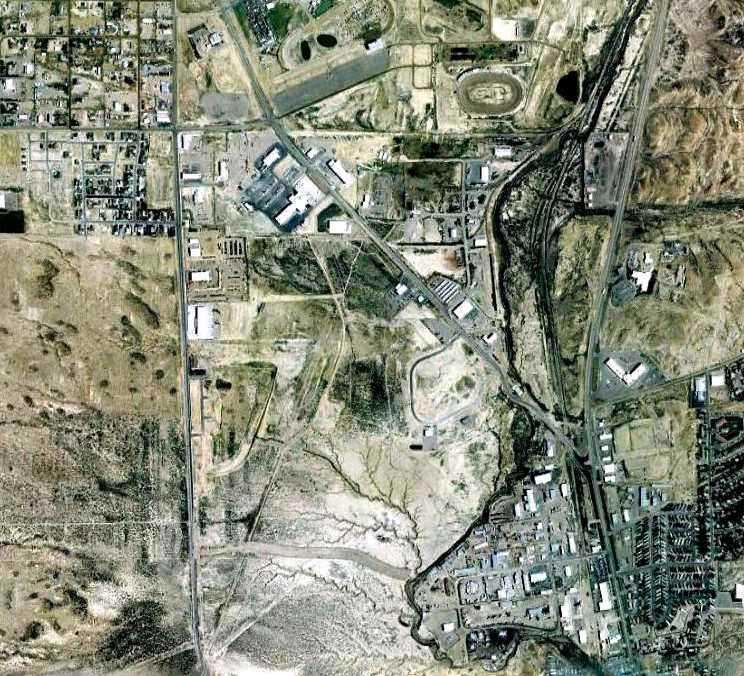
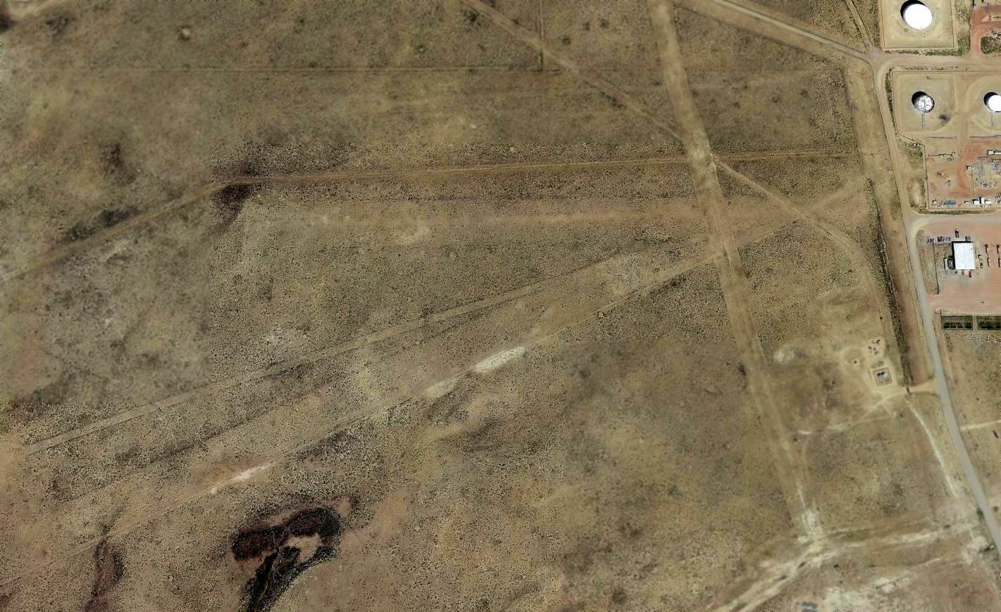
A 7/5/09 aerial photo of the site of the original Rock Springs Airport shows what may be the traces of several runways.
Robbie reported in 2018, “None of the currant buildings on the site of the old Rock Springs field are from the days of the airmail service.
The old site now is the fairgrounds. It has a car racetrack, indoor/outdoor horse arenas, display buildings, and a golf course now on that site.
I don`t think any of the roads/streets are from the airstrip days (except the main access road), everything else is now long gone.
Not many folks now even know there was a airstrip on the site (too bad).”
According to Curtis Carroll, “The original Rock Springs Municipal Airport... was located on the site of what is now the Sweetwater County Fairgrounds”,
northwest of the intersection of Route 191 & Yellowstone Road.
____________________________________________________
41.54, -109.59 (Northwest of Cheyenne, WY)

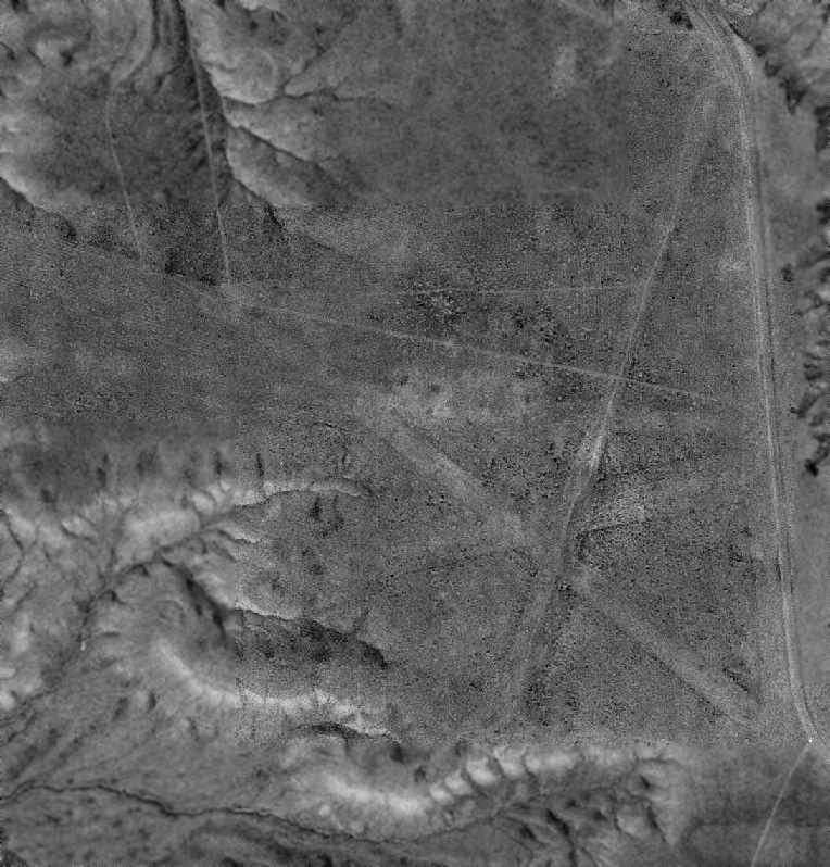
The Igo Airfield, as depicted on a 7/2/54 USGS aerial view.
Not much is known about this airfield, including its purpose or date of construction.
The earliest depiction which has been located of the Igo Airfield was a 7/2/54 USGS aerial view.
It depicted a total of 4 unpaved runways, but there were no buildings or aircraft visible on the airfield.
No airfield was depicted at this location on the 1956/60/69 Salt Lake Sectional Charts or the 1962 USGS topo map.
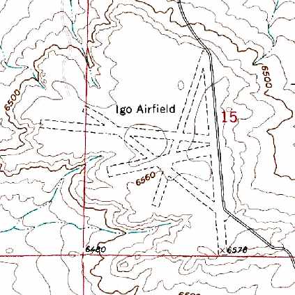
The earliest topo map depiction which has been located of the Igo Airfield was on the 1980 USGS topo map.
It depicted “Igo Airfield” as having a total of 4 unpaved runways, with the longest being the 4,700' north/south strip.
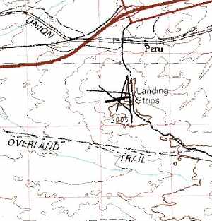
The 1981 USGS topo map depicted the 4 runways of Igo Airfield, but labeled the field simply as “Landing Strips”.
In the 1994 USGS aerial photo, the 4 runways of Igo Airfield were barely recognizable.
There did not appear to be any buildings at the airfield, nor any indication of recent usage.
As of 2005, no active airfield at this location is listed among the FAA's Airport/Facility Directory data.
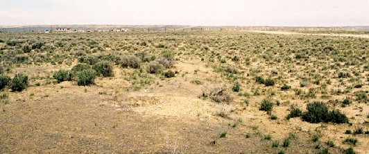
A 2005 photo by Robert Pearson, “on the north/south runway west edge showing the transition from the large sagebrush to the smaller on the runway.
There are a bunch of buried pipelines nearby & that makes me think the airport was affiliated with them (Intermountain Gas & Oil?).”
A 2013 aerial view showed the majority of the 4 runways of Igo Airfield remained recognizable,
but some type of facility (a junkyard?) had been built at some point between 1994-2013 on the northeast corner of the airfield site.
Igo Airfield is located southwest of the intersection of Interstate 80 & Route 372.
____________________________________________________
American Legion Airport / Douglas Intermediate Field /
Douglas Municipal Airport / (Original) Converse County Airport (DGW), Douglas, WY
42.74, -105.37 (Northwest of Cheyenne, WY)
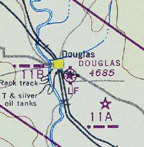
American Legion Airport, as depicted on the December 1935 Casper Sectional Chart.
The date of establishment of the airport on the southeast side of Douglas has not been determined.
The earliest depiction which has been located of American Legion Airport
was on the December 1935 Casper Sectional Chart.
It depicted “American Legion” as a commercial/municipal airport.
The Airport Directory Company's 1937 Airports Directory (courtesy of Bob Rambo)
described "Legion" Airport as having a single 2,640' east/west sod runway & a hangar.
The airport was evidently renamed Douglas Airport at some point between 1937-43,
as that is how it was labeled on the July 1943 Casper Sectional Chart (courtesy of Chris Kennedy).
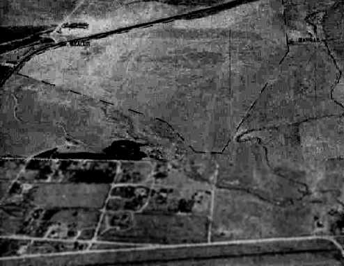
A 9/12/43 aerial view looking south from the 1945 AAF Airfield Directory (courtesy of Scott Murdock)
depicted Douglas Intermediate Field as an open grass area.
The Douglas Airport was listed in the 1944 US Army/Navy Directory of Airfields (courtesy of Ken Mercer)
as being "Site 11B", a department of Commerce Intermediate Field along the "CX-GT" airway.
It was described as having a 4,000' unpaved runway.
The 1945 AAF Airfield Directory (courtesy of Scott Murdock) described Douglas Intermediate Field
as a 169 acre triangular property within which were 2 sod runways, measuring 4,000' northwest/southeast & 3,115' northeast/southwest.
The field was said to have a single 50' x 30' metal hangar,
to be owned by the Town of Douglas, and to operated by the Civil Aeronautics Administration.
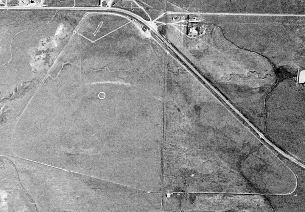
A 6/30/47 USGS aerial photo depicted the Douglas Municipal Airport as a triangular open area, with no discrete runways.
A few small buildings were depicted on the north & south sides of the field.

The 1949 USGS topo map depicted the Douglas Municipal Airport as a triangular open area, with no discrete runways.
Two small buildings were depicted along the north side of the field.
By 1962, the airport had been renamed & the primary runway had been paved,
as the 1962 AOPA Airport Directory described the "Converse County" Airport at this location
as having a 5,000' bituminous Runway 10/28 & a 3,160' turf Runway 6/24.
The operators were listed as R & G Aircraft Service and Hart Aircraft Service.
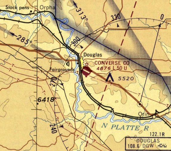
The last aeronautical chart depiction which has been located of the original Douglas Converse County Airport was on the April 1970 Casper Sectional Chart.
It depicted Converse County Airport as having a 5,000' paved northwest/southeast runway.
Rod McKenzie recalled, "I was based at Douglas Airport from 1978-81.
I was chief pilot for on oil company called Chinook Pipeline Resources.
We operated a Sabreliner 40 & a King Air 90. The King Air 90 was later replaced by a King Air B200.
Our Sabreliner was sort of a conversation piece among the local population.
They actually seemed to like the noise and commotion (go figure that one in these noise restricted days).
When we sold the aircraft, word leaked out & probably a hundred or so of the locals came out to see the old girl off.
Naturally several high speed fly-bys were in order.
The airport had a considerable slope downhill to the West (Runway 28).
Takeoffs were primarily to the West but landings upslope on Runway 10
were preferred if the winds were light (a rare occurrence in Wyoming).
The White, elongated rectangle at the top of the [above aerial photo] was where we built our hangar.
It had three 60' bays. The other rectangles were T-hangars if I remember correctly. R & G aircraft was the operator.”
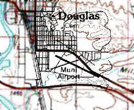
The 1981 USGS topo map depicted the Douglas Municipal Airport as having 2 runways.
Two small buildings were depicted along the north side of the field.
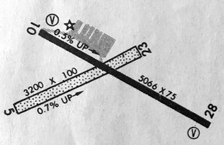
The 1982 AOPA Airport Directory (courtesy of Ed Drury) described Converse County Airport
as having a 5,066' asphalt Runway 10/28 & a 3,200' turf Runway 5/23.
It listed the operator as R & G Aircraft Service.
The last depiction which has been located of the original Douglas Converse County Airport
was on the 1983-84 WY Aeronautical Chart (courtesy of Alex Hauzer).
It depicted Douglas Converse County Airport as having a 5,066' paved Runway 10/28 & a 3,200' unpaved Runway 5/23.
Rod McKenzie recalled, "The oil bust in the early 1980s sealed the fate of our company.
Sometime in the mid 1980s a new airport [Converse County Airport ] was built about 6 miles north of town
and this airport was closed & all the buildings, hangars, and etc were torn down.
I understand the airport was used as a drag strip after that.
This is evident by the twin black streaks on the west end as seen in the aerial photos."
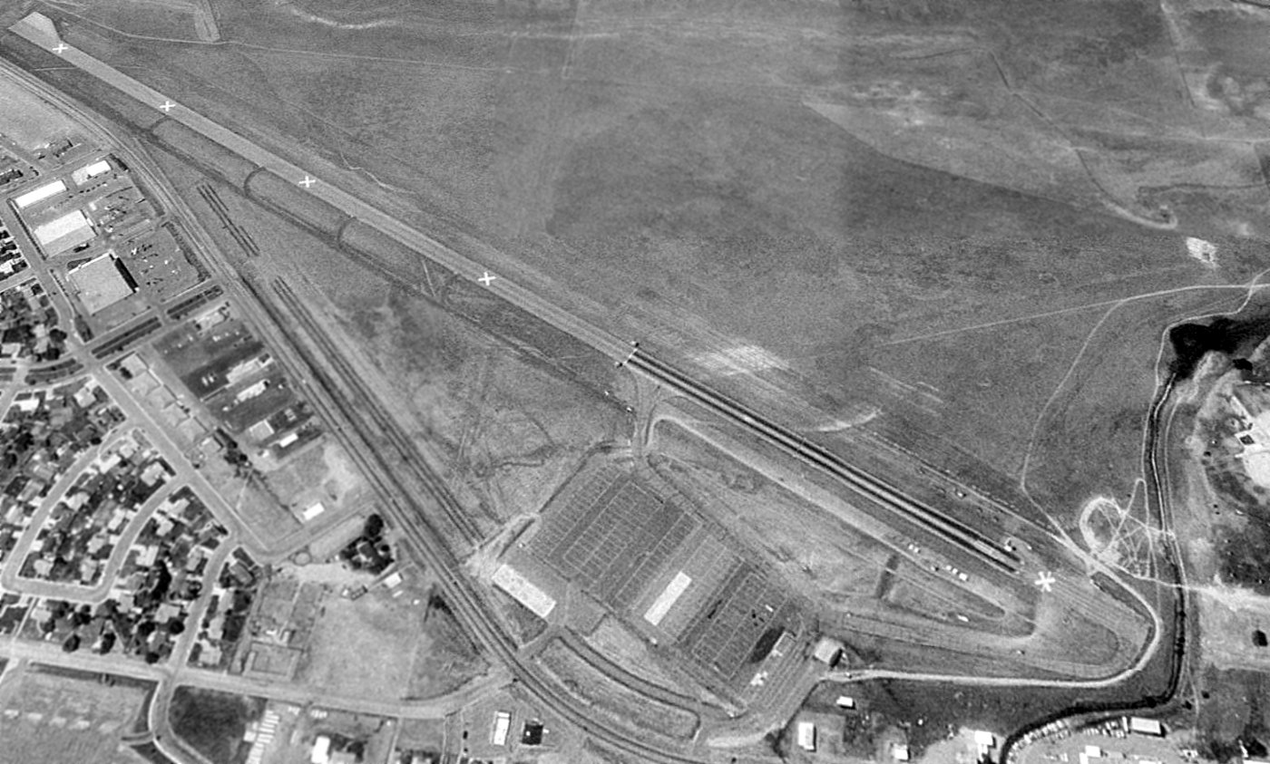
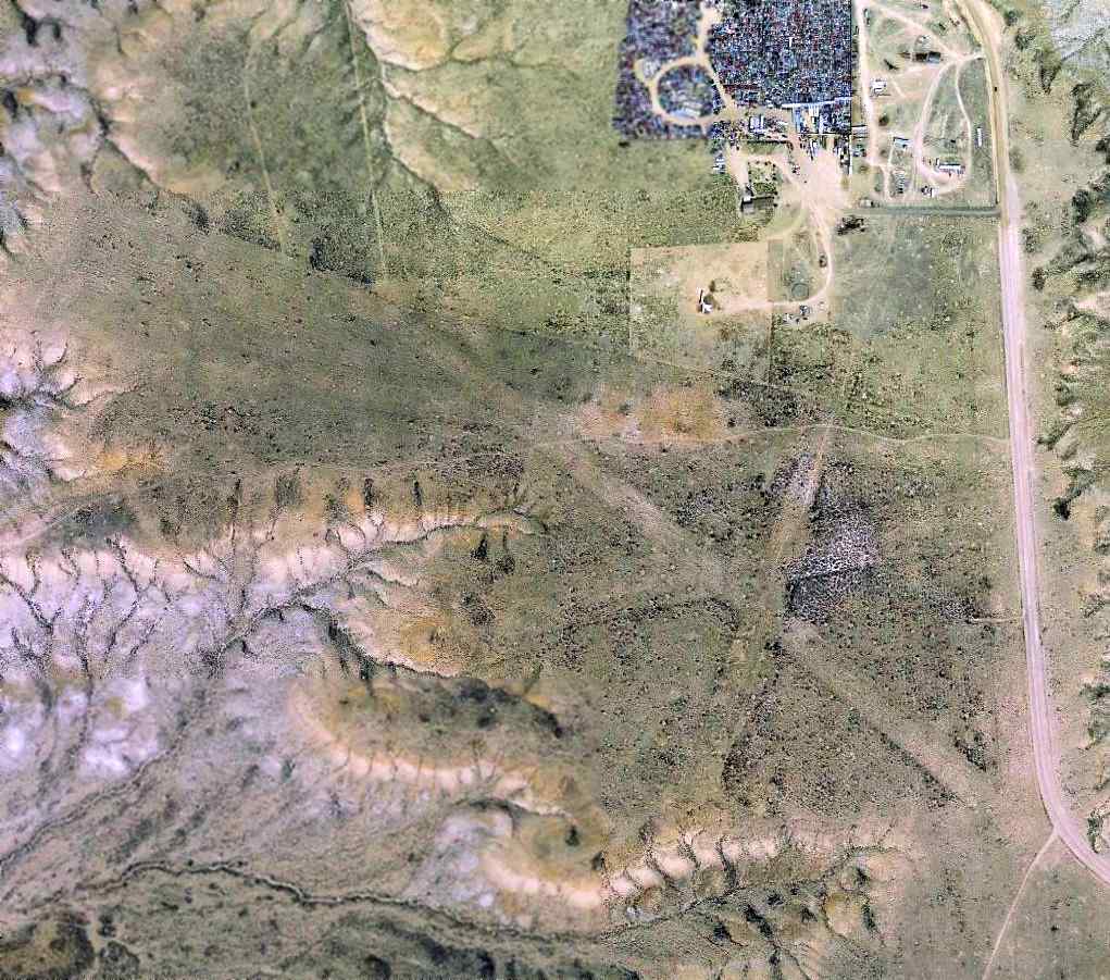
A 1994 USGS aerial view looking south showed the original Douglas Airport paved runway was clearly marked with closed runway "X" markings, and also showed signs of having been reused for drag racing.
The outline of the grass crosswind runway was also still recognizable. The ramp area north of the runway had a series of rectangular features which appeared to be foundations of former hangars.
The original Douglas Airport was depicted as an abandoned airfield on 2003 aeronautical charts.
Rick Caldwell reported in 2005, “The strip at Douglas is in great shape but it is now used as the Douglas race track.
They have drag races in the summer.
If the need were to arrive I would think twice about landing there.
You could get passed by some very fast automobiles though.”
As of 2009, street maps labeled the former airport site as “P Chariot Race Track”.
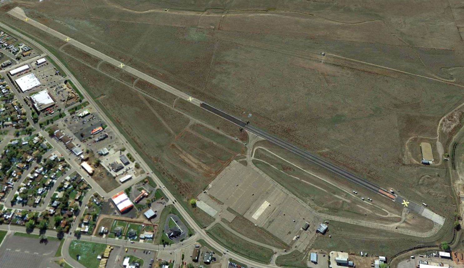
A 2013 aerial view looking south showed the paved runway of the original Douglas Airport had evidently been reused for drag racing.
Douglas Municipal Airport is located northwest of the intersection of Interstate 25 & Business 25.
Thanks to Chris Kennedy for pointing out this airfield.
____________________________________________________
Evanston Flying Club Airfield / (Original) Evanston Municipal Airport (EVW), Almy, WY
41.35, -111 (Northeast of Salt Lake City, UT)
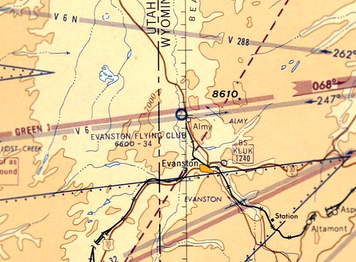
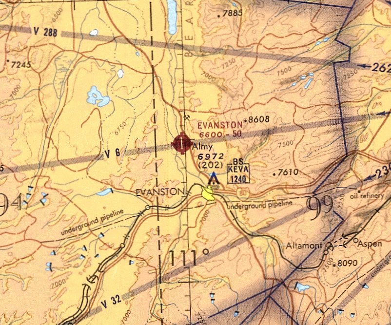
Evanston Flying Club Airfield, as depicted on the October 1960 Salt Lake City Sectional Chart.
Photo of the airport while open has not been located.
According to Barbara Bogart (Director of the Uinta County Museum), “In 1959, the Evanston Fliers, a local flying club,
built a dirt runway at Almy, north of Evanston.”
The Evanston Flying Club Airfield was not yet depicted on the March 1960 Salt Lake City Sectional Chart.
The earliest depiction which has been located of the Evanston Flying Club Airfield was on the October 1960 Salt Lake City Sectional Chart.
It depicted the Evanston Flying Club Airfield as having a 3,400' unpaved runway.
The 1962 AOPA Airport Directory described the Evanston Municipal Airport as having a single 3,400' clay Runway 18/36.
According to Barbara Bogart, “In 1963 the City of Evanston took over operations of the strip, making it the Evanston Municipal Airport.”
The Evanston Airport was depicted on the May 1965 Salt Lake City Sectional Chart (courtesy of Chris Kennedy)
as having a 4,300' unpaved runway.
According to Barbara Bogart, “The runway was paved in 1968.”

The 1968 USGS topo map depicted Evanston Municipal Airport as having a paved northwest/southeast runway,
with a paved ramp leading to 2 small buildings on the southwest side.
The last aeronautical chart depiction which has been located of the original Evanston Airport was on the May 1971 Salt Lake City Sectional Chart (courtesy of Ron Plante).
It depicted Evanston as having a single north/south 5,000' paved runway.
The 1976 USGS topo map depicted Evanston Municipal Airport in the same fashion as depicted on the 1968 map.
The 1982 AOPA Airport Directory (courtesy of Ed Drury) described Evanston Municipal as having a 5,000' asphalt Runway 16/34.
It listed the operator as Evanston Aviation Inc.
According to Barbara Bogart, “The new Evanston airport, located about 3 miles northwest of downtown was opened in 1984.”
The old Evanston Airport was presumably closed at that time.
Nothing of the original Evanston Municipal Airport was depicted at all (even the runway) on the 1991 USGS topo map
(which is odd, as a 1994 aerial photo shows that the runway still was completely intact 3 years later).
The original Evanston Municipal Airport was depicted as an abandoned airfield on the 1993 Salt Lake Sectional Chart.
The original Evanston Municipal Airport's runway apparently had been lengthened by another 1,000' at some point between 1982-94,
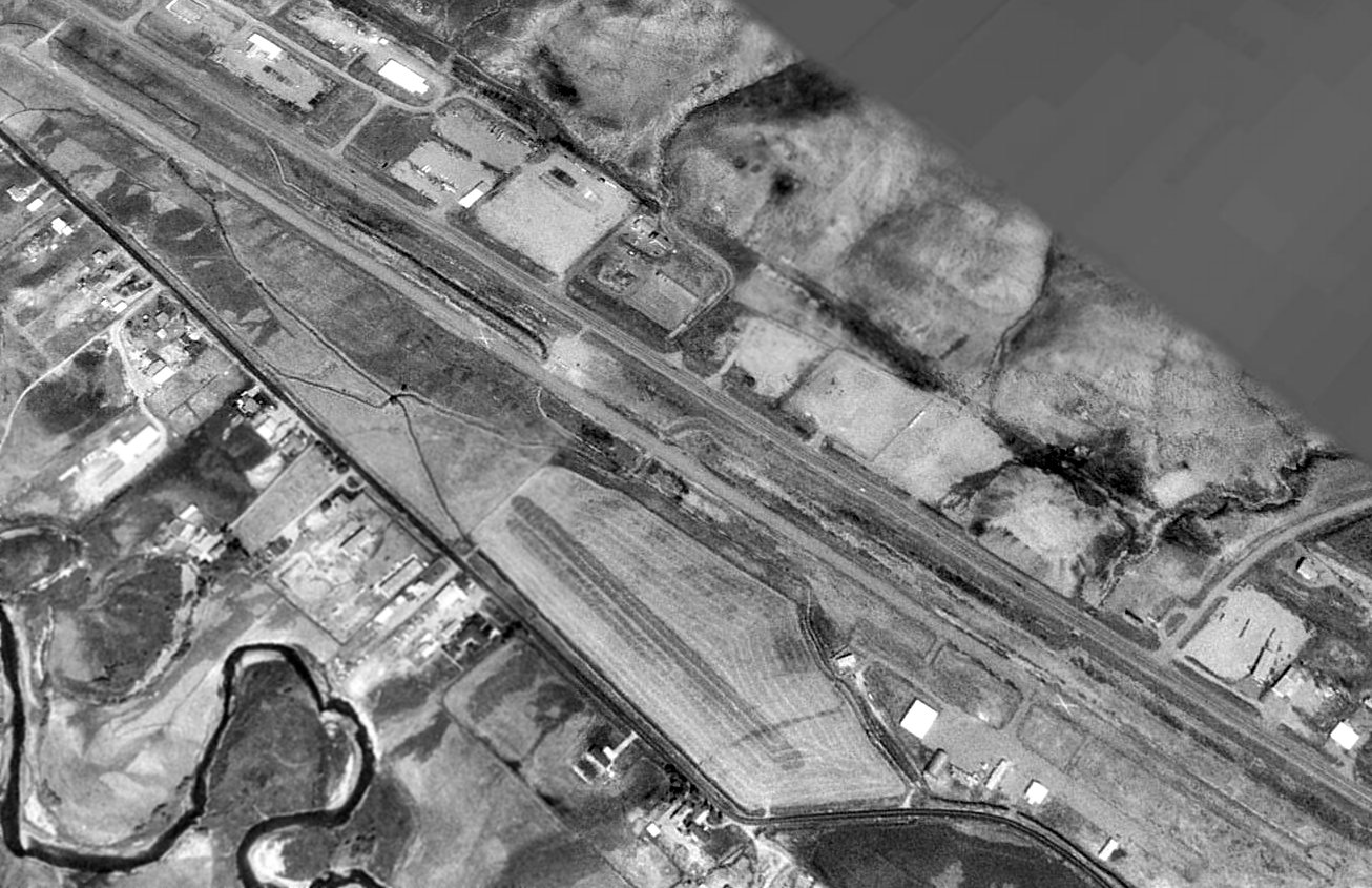
as a 1994 USGS aerial view looking northeast depicted Evanston as having a single 6,000' paved runway.
Several closed-runway "X" symbols were clearly evident on the runway,
and a small ramp at the southwest end of the runway had several buildings or hangars.
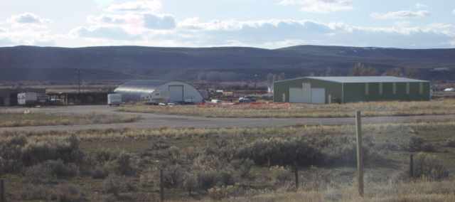
A 2005 photo by Keith Wood of some of the former hangars of the original Evanston Municipal Airport.
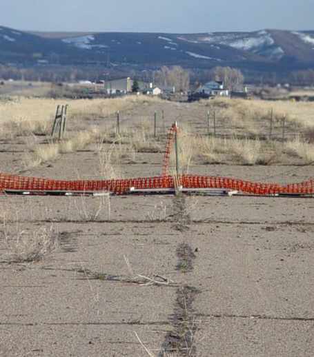
A 2005 photo by Keith Wood looking along the runway of the original Evanston Municipal Airport.
Keith reported, “This field was in good shape except for being ignored,
except for the barbed-wire fence driven into the runway along lot lines intended for development.”
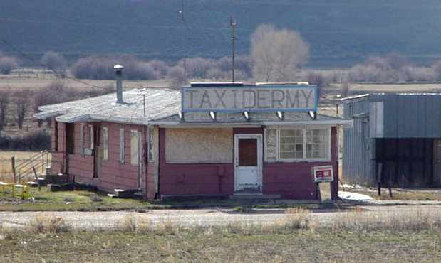
A 2005 photo by Keith Wood, of “The former FBO building, now abandoned.
Was this used as a shop to stuff elk, or is it a pun ('Taxi dermy')?”
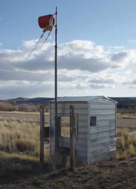
A 2005 photo by Keith Wood of the former windsock frame attached to a shed at the site of the original Evanston Municipal Airport.
A 2014 aerial view looking northeast showed the runway & hangars of the original Evanston Municipal Airport's runway remained intact though deteriorated.
Evanston Municipal Airport is located on the west side of Route 89, north of its intersection with Moon Way.
Thanks to Chris Kennedy for pointing out this airfield.
____________________________________________________
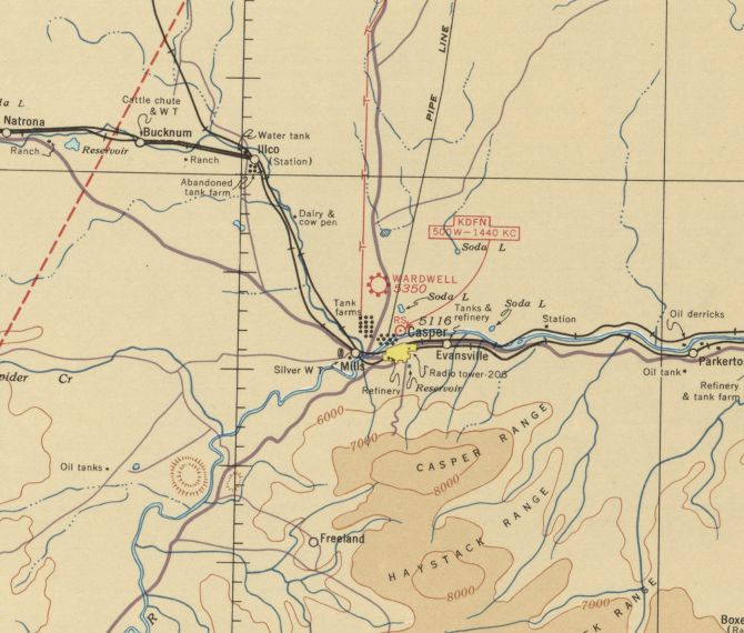
42.91, -106.35 (North of Casper, WY)
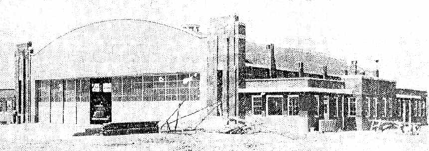
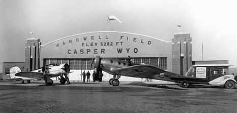
A 1934 photo of the newly constructed hangar at Wardwell Field (courtesy of Marianne Hofsheier).
This 640-acre airport was built in 1927, as Natrona County's airport.
In 1929, the county commissioners named the airport in memory of Major Doyan Wardwell,
who died in an airplane crash at the airport earlier that year.
Wardwell had helped develop the early airport.
A 1934 newspaper (courtesy of Marianne Hofsheier) had a photo of Wardwell's newly constructed hangar.
The caption read, “Casper's new $125,000 airport will be dedicated Sunday at Wardwell Field,
seven miles north of the city on the Salt Creek Highway.
The exercises will mark the completion of the construction of the airport
and the inauguration of the new north & south airmail route from Billings, MT to Denver, CO via Casper.
Wyoming congressional delegates, state officials, Governor Ed Johnson of CO
and thousands of visitors from WY & neighboring states are expected to attend the exercises
which will be followed by an elaborate air exhibition.”

A 5/30/35 photo of a Waco biplane & 2 Stinson Sr Reliants (Sr-5s or Sr-6s) in front of the Wardwell Field hangar (courtesy of Linda Reverchon).
The caption on the back of the photo included, “5/3/35... landed at Wardwell Field on the day it was first opened to the public... plane Waco 2 passenger.”

A circa 1930s photo of spectators & planes in front of the Wardwell Field hangar (photographed 6/16/19 by Charlie Brown, as on display in The Hangar, the former Wardwell Field hangar).
The earliest aeronautical chart depiction which has been located of Wardwell Field was on the December 1935 Casper Sectional Chart.
It depicted Wardwell as a commercial/municipal airport.
A circa 1937-40s photo (courtesy of Troy Jackson) of Wardwell Field's hangar.
Troy reported, “I found a little box in a junk store in Amarillo that had 6 rolls of film in it.
Kodak used to put their film in little metal canisters, and those were the main reason I bought them.
Then I started looking at the negatives & decided to scan them all.
The box that the negatives were in was from an Argus camera, one of their models only made in 1937-38.
So, IF these pictures were taken with that camera, then it was probably in the late 1930s to early 1940s.”
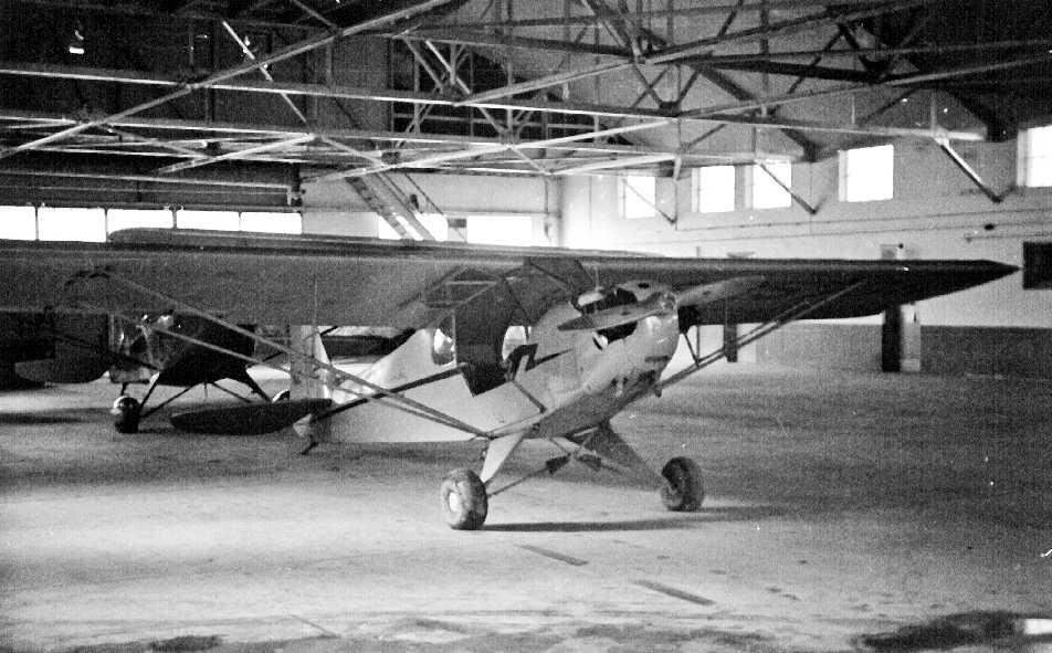
A circa 1937-40s photo (courtesy of Troy Jackson) of a Cub & another taildragger inside Wardwell Field's hangar.
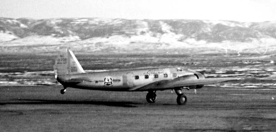
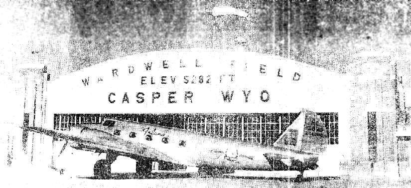
A circa 1937-40s photo (courtesy of Troy Jackson) of a Inland Airlines Boeing 247 taking off or landing at Wardwell Field.
An undated photo of a Lockheed Orion & a Boeing Monomail (one of only 2 ever built) in front of the Wardwell Field hangar.
According to Max Platts, “The Monomail appears to be in Inland Airlines Livery
and I am assuming that the Orion is either a Wyoming Air Service Orion or possibly an Inland bird as well.”
A 1941 photo from the Casper Tribune-Herald of a Boeing 247 in front of Wardwell Field's hangar (courtesy of Marianne Hofsheier).
The caption read, “Inland Air Lines observes 10th Birthday.”
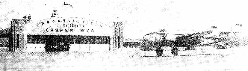
A 1942 photo of a “giant silver & blue” Lockheed Lodestar “as it landed from a trial hop at Wardwell Field” (courtesy of Marianne Hofsheier).
The caption noted that the Lodestar was soon to be put into service by Inland.
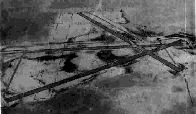
A 9/12/43 aerial view looking north from the 1945 AAF Airfield Directory (courtesy of Scott Murdock)
depicted Wardwell Field as having 3 asphalt runways & a 4th unpaved runway.
The 1945 AAF Airfield Directory (courtesy of Scott Murdock) described Warwell Field
as a 629 acre irregularly-shaped property within which were three 5,200' asphalt runways & a 4th unpaved runway.
The field was said to have a single 150' x 100' brick & steel hangar.
Wardwell Field was described as having service by Inland Airlines,
to be owned by Natrona County, and to operated by private interests.
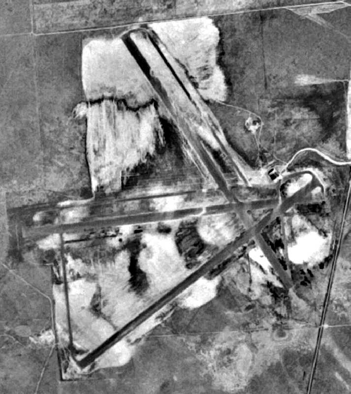
The last photo which has been located showing Wardwell Field in operation was an 11/5/47 USGS aerial view.
It depicted Wardwell Field as having 3 asphalt runways & a hangar on the northeast side.

An undated photo of the Wardwell Field hangar surrounded by snowdrifts from a blizzard in early January 1949 (photographed 6/16/19 by Charlie Brown, as on display in The Hangar, the former Wardwell Field hangar).
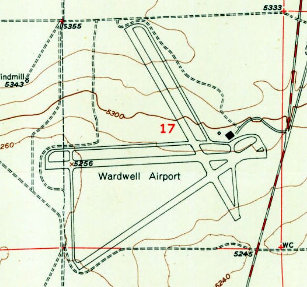
The last depiction which has been located of Wardwell Airport was on the 1951 USGS topo map,
which depicted Wardwell as having 3 paved runways & a hangar on the northeast side.
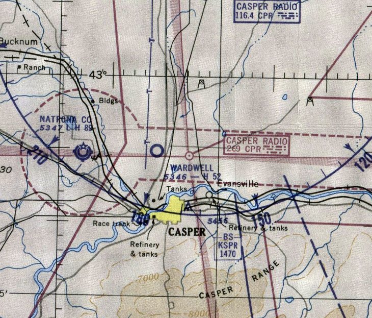
The last aeronautical chart depiction which has been located of Wardwell Field was on the April 1952 Casper Sectional Chart.
It depicted Wardwell as having a 5,200' paved runway.
In 1952, the county airport was moved to the former Casper Army Airfield.
Wardwell Field was no longer depicted on the May 1953 Casper Sectional Chart.
Wardwell Field was sold in 1954 for the sum of $20,500 to Romie Nunn.
The abandoned airport contained 6 miles of paved runways.
When Romie Nunn bought Casper's old airport, he had great hopes for what his 640 acres would become,
but he didn't know it might become a town named after him.
Romie Nunn always hoped the area would be used for raising horses & for horse racing.
"I was going to make the horse center of the Rockies out of that place," Nunn said.
"I wanted ranch-style homes on those large lots I put in.
I thought everyone who would live out there would have a horse.
This would be known around the world if we had that," he added.
From 1954-72, Nunn sponsored a variety of activities on the land,
including square dances, rodeos, a national road race, drag races, and even the filming of a movie.
He began to use the old airport hangar as an indoor arena.
"We'd put on at least one rodeo a week and they'd rope in there almost every night," Nunn said.
In 1956, the National Road Race was held on the old runways, and later, other car races were run there.
In 1958, Nunn subdivided the area, calling it the Bar-Nunn Ranch Subdivision (he acquired the Bar-N brand later).
He allowed for residential lots, the indoor riding arena, a half-mile race track, an outdoor riding arena,
and 4 miles of bridle path around the perimeter of the subdivision.
Nunn set aside land for parks, a school, churches, and businesses,
all laid out along streets which were in fact the old runways of Wardwell Field.
The foresighted developer was dubbed "The Runway Rancher" in a 1959 Denver Post Empire Magazine story.
"When you buy a ranch and build an airport on it, that's one thing.
But when you buy an airport and make a ranch out of it, that's Wyoming!" Empire said.
In the 1960s, part of the movie "The Hellfighters", starring John Wayne, was filmed on Bar Nunn's old runways.
The movie's directors landed a large plane on the runway, a re-creation of a South American airport.
Romie Nunn sold all but 10 lots of the Wardwell Field property in 1972.
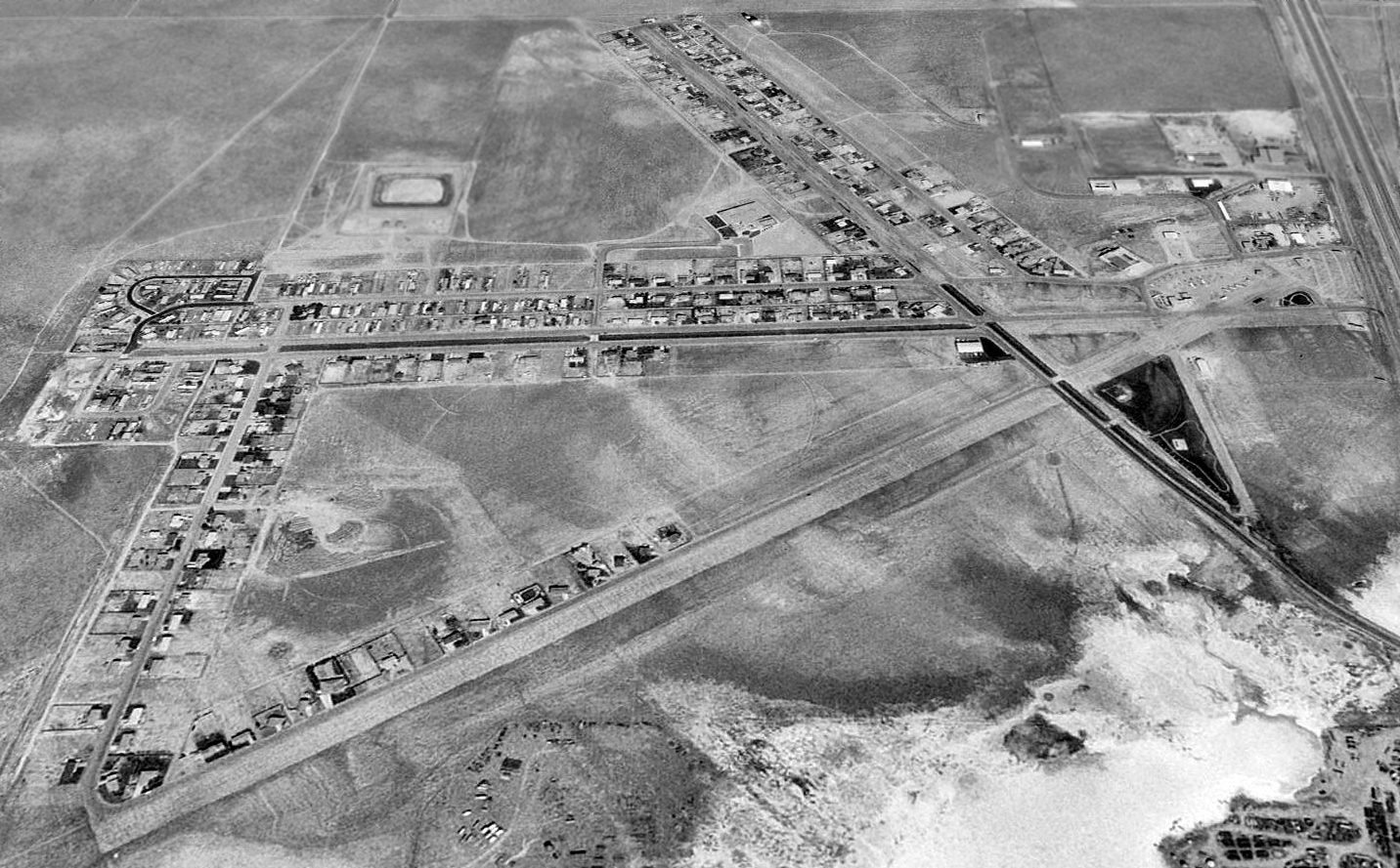
A 1994 USGS aerial view looking north showed Wardwell Field's 3 paved runways were still plainly evident,
with the former runways being reused as streets of the town.
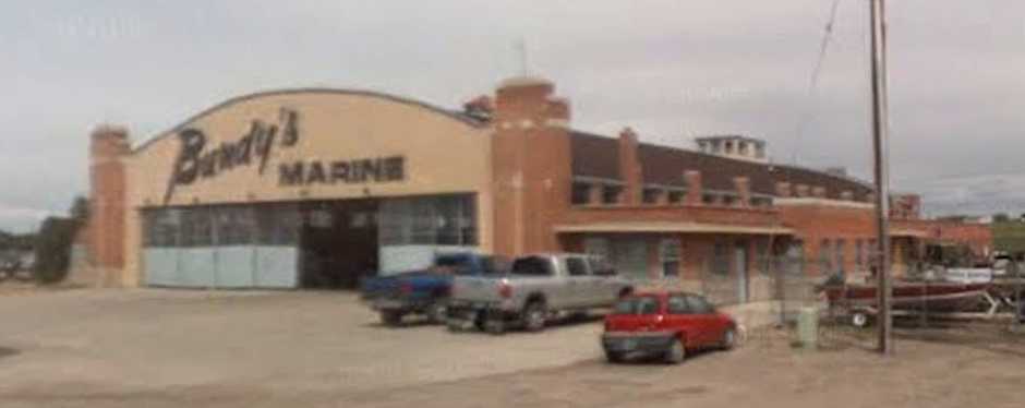
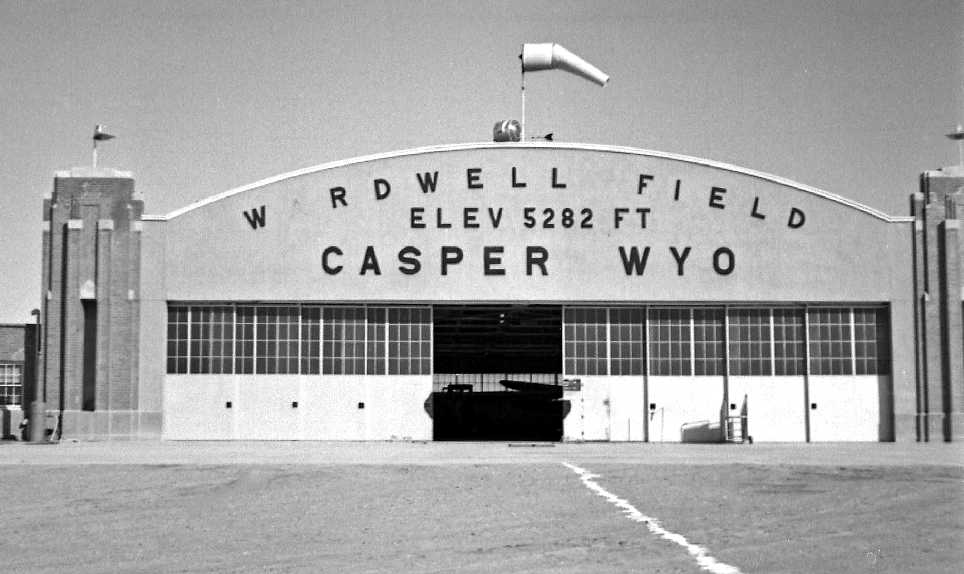
A circa 2007 photo looking west at the former Wardwell hangar, now marked with “Bundy's Marine”, and used for boat storage.
A sign on the exterior of the former hangar reportedly still reads "Wardwell Field, Elev. 5,282".
Wardwell Field's former runways are no longer depicted as an airfield on recent USGS topo maps,
but they are still depicted as an abandoned airfield on current aeronautical charts.
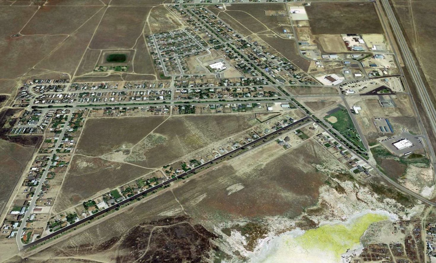
A 2015 aerial view looking north showed Wardwell Field's 3 paved runways were still plainly evident, with the former runways being reused as streets of the town.

A 6/16/19 by Charlie Brown looking northwest at The Hangar, a bar which occupies the former Wardwell Field hangar.

A 6/16/19 by Charlie Brown looking southeast at The Hangar, a bar which occupies the former Wardwell Field hangar.

A 6/16/19 by Charlie Brown looking east at The Hangar, a bar which occupies the former Wardwell Field hangar.

A 6/16/19 by Charlie Brown looking southeast at a North American Harvard II wing mounted on the east side of The Hangar, a bar which occupies the former Wardwell Field hangar.

A 6/16/19 by Charlie Brown of the sign for the Barr Nunn community which occupies the former Wardwell Field, featuring the former runway layout.

A 6/16/19 by Charlie Brown of a street in the Barr Nunn community, overlaid on a former Wardwell Field runway.

A 2025 photo of an unidentified biplane mounted inside The Hangar, the bar which occupies the former Wardwell Field hangar.
Inexplicably, this civilian biplane has a bomb mounted under its left wing.
See also: http://www.trib.com/WYOMING/NCSD/BARNUNN/bnhistory.html
____________________________________________________
Since this site was first put on the web in 1999, its popularity has grown tremendously.
If the total quantity of material on this site is to continue to grow,
it will require ever-increasing funding to pay its expenses.
Therefore, I request financial contributions from site visitors,
to help defray the increasing costs of the site
and ensure that it continues to be available & to grow.
What would you pay for a good aviation magazine, or a good aviation book?
Please consider a donation of an equivalent amount, at the least.
This site is not supported by commercial advertising –
it is purely supported by donations.
If you enjoy the site, and would like to make a financial contribution,
you
may use a credit card via
![]() :
:
![]()
Please consider checking the box to make a monthly donatation.
For a mailing address to send a check, please contact me at: paulandterryfreeman@gmail.com
If you enjoy this web site, please support it with a financial contribution.
____________________________________________________
This site covers airfields in all 50 states.