Abandoned & Little-Known Airfields:
Western Alaska
© 2003, © 2025 by Paul Freeman. Revised 12/12/25.
This site covers airfields in all 50 states: Click here for the site's main menu.
____________________________________________________
Please consider a financial contribution to support the continued growth & operation of this site.
Alexai Point Army Airfield (revised 9/5/25) - Amchitka AAF / Amchitka AFB (revised 9/5/25) - Original Bethel Airport (revised 3/6/14)
Bethel Airport (2nd location) (revised 4/1/18) - Deering Airport (original location) (revised 12/12/25) - Ft. Glenn AAF / Otter Point NAF (revised 12/12/25)
Fort Glenn North Satellite Army Airfield / North Shore Airfield (added 12/14/25) - Ft. Randall AAF Satellite Field (added 11/2/13)
Newtok Airport (added 3/8/24) - Ogliuga Army Airfield (added 11/17/15) - Point Spencer AFB (revised 12/12/25)
Shishmaref Airport (original location) (revised 12/12/25) - Western Shemya Army Airfield (revised 4/27/16)
____________________________________________________
Newtok Airport (EWU / WWT), Newtok, AK
60.938, -164.64 (West of Anchorage, AK)
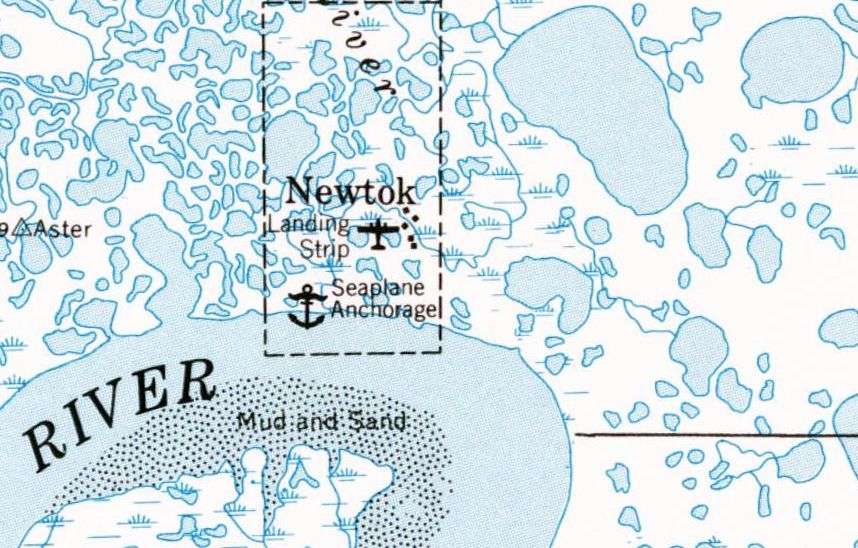
Newtok Airport, as depicted on the 1954 USGS topo map.
The date of construction of this small remote Alaskan airport has not been determined.
The earliest depiction which has been located of Newtok Airport was on the 1954 USGS topo map, which labeled it generically as “Landing Strip”.
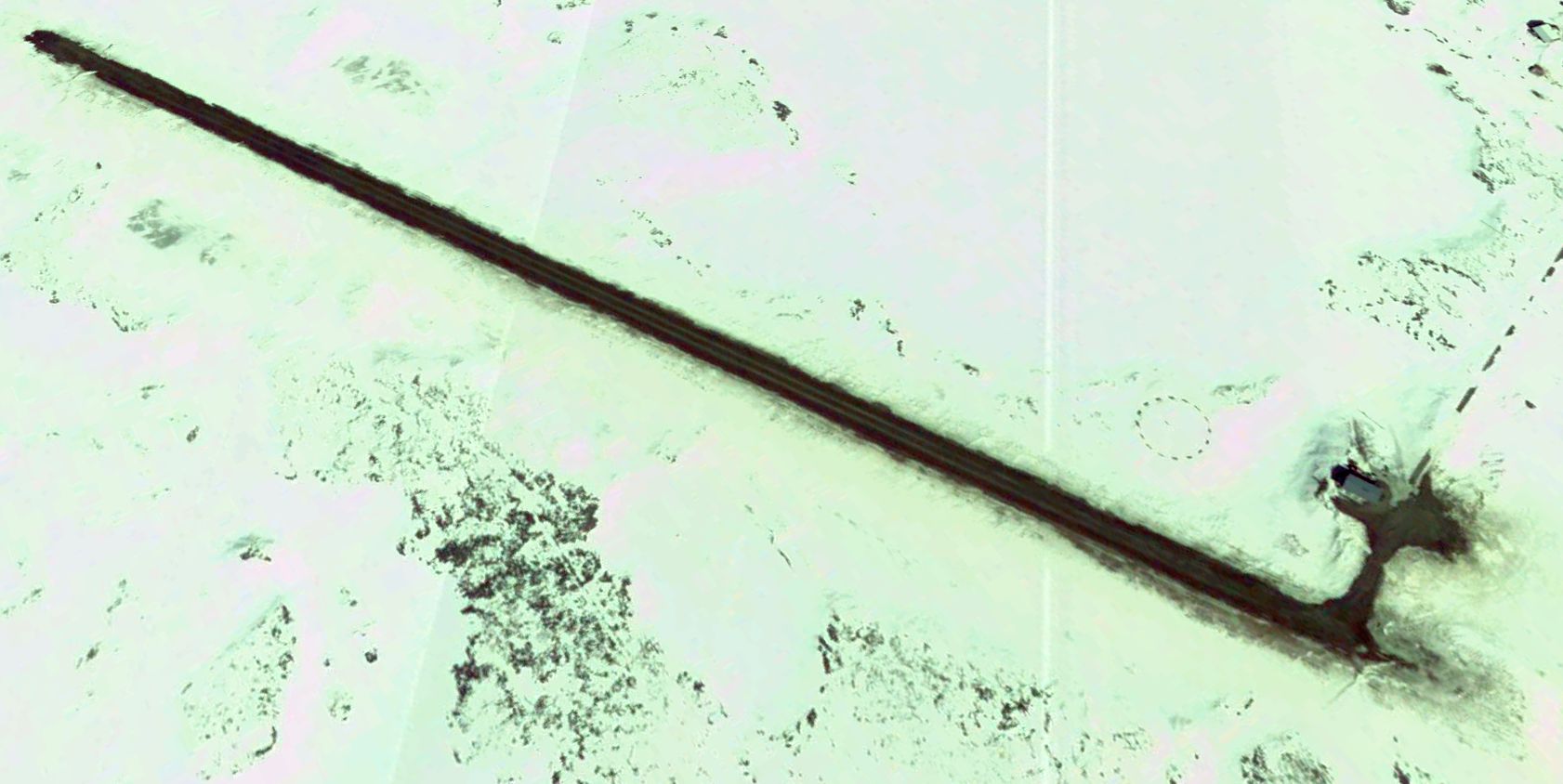
The earliest photo which has been located of Newtok Airport was a 2005 aerial view looking northeast, which depicted a single asphalt northwest/southeast runway, with a small paved ramp & a small building on the southeast side.
There were no aircraft on the field.
 d
d
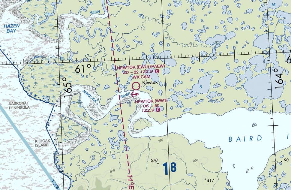
The earliest aeronautical chart depiction which has been located of Newtok Airport was on the July 2017 Bethel Sectional Chart.
It depicted Newtok Airport as having a 2,200' unpaved runway.
The last aeronautical chart depiction which has been located of Newtok Airport was on the July 2019 Bethel Sectional Chart.
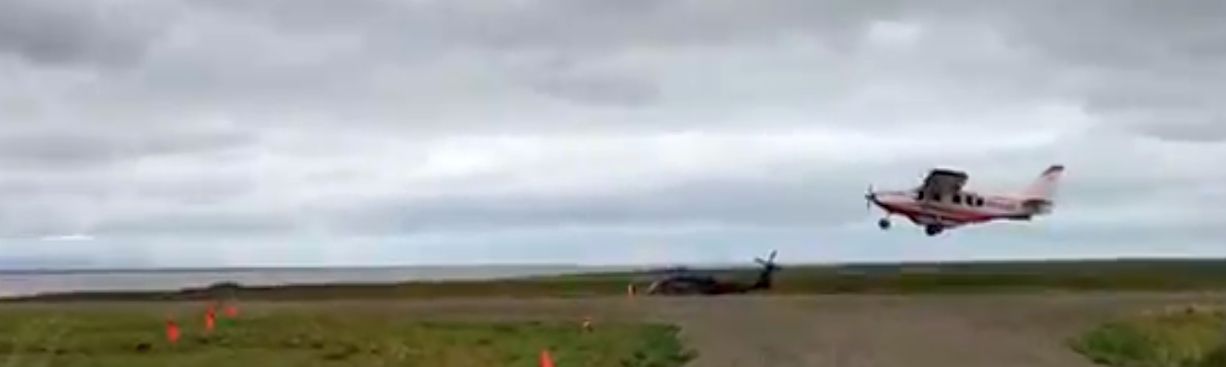
The only photo which has been located showing aircraft at Newtok Airport was a 2019 photo,
which showed an Army (or National Guard) Sikorsky UH-60 Blackhawk next to the runway, and a civilian single-engine plane taking off.
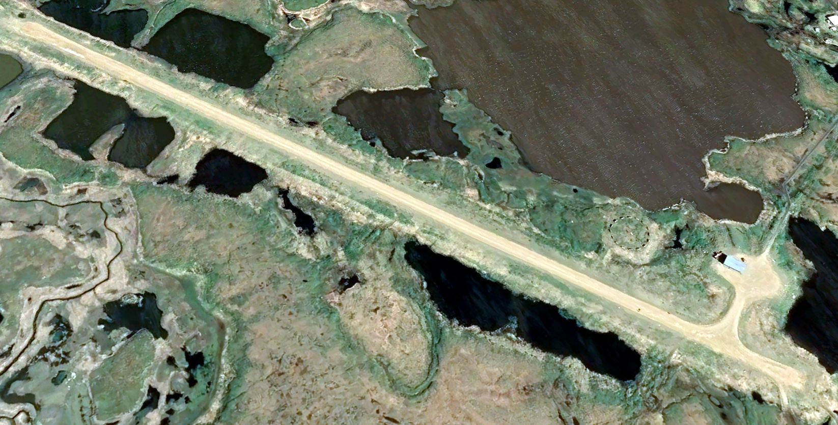
A 2022 aerial view looking northeast at Newtok Airport depicted the field in an unchanged configuration.
Nick Gosselin reported in 2024, “Newtok has been in the news for the past decade because erosion from the inlet is quickly consuming the town.
Within the past few years, the village has been moving to a new location about 8 miles south, named Mertarvik.
The original village of Newtok still is occupied as there is not enough housing yet for all the families to move to Mertarvik.
The original runway is still in use, although it doesn't get much maintenance anymore & is relatively short & narrow (2,200' x 30', on paper if not in reality).
Multiple local air carriers still service the town with Cessna Caravans, 207s, and similar, but as soon as the last family has moved there likely will be no reason to fly to Newtok any longer.
As of the past year & a half the original Newtok Airport was removed from the Bethel Sectional.
The Newtok seaplane base is still listed on the Sectional using the old Newtok Airport's identifier (WWT).”
Thanks to Nick Gosselin for pointing out this airfield.
____________________________________________________
Deering Airport (original location), Deering, AK
66.079, -162.734 (Northeast of Nome, AK)
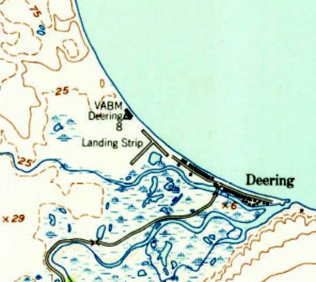
The original Deering Airport, as depicted on the 1957 USGS topo map.
Photo of the airfield while in use has not been located.
According to Jim Moffett, “Deering is on the Seward Peninsula about 200 miles east of Russia.
Deering has less than 200 inhabitants & is the 113th largest city in Alaska & the 17,141st largest city in the United States.
My fascination with the place started 40 years ago when I was a controller at Fairbanks Tower. I somehow stumbled across it in the Alaska Chart Supplement.
I'd like to say that it was because I was a true professional & spent my every waking hour reading various FAA publications
but in reality the midnight shifts at the tower in the winter provided a lot of free time & you can only play Zork on the tower cab's computer so many times before your mind turns to other things,
and since the
Internet was in its infancy the library of FAA pubs had to
suffice.
And so I discovered Deering. I was browsing
through the airport sketches & descriptions (lots of mentions
like, 'Runway ends in hill; successful go-around improbable')
when I found an impossibility: Deering had Runway 12/28. As yours probably does, my mind recognizes runway number pairings & Runways 12 & 28 were NOT 180° different.
The runway used the beach, as did the locals as it was also the road (and I do mean the road).”
The earliest depiction which has been located of the original Deering Airport was on the 1957 USGS topo map.
It depicted 2 perpendicular runways, generically labeled “Landing Strip”, directly adjacent to the ocean.
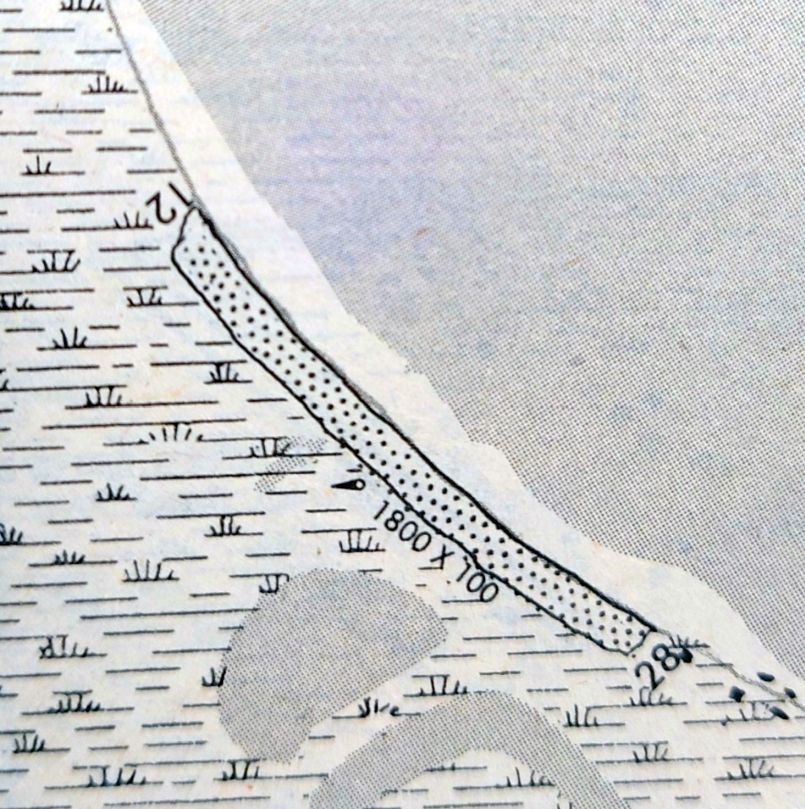
The only aeronautical chart depiction which has been located of the original Deering Airport was on the 1984 AK Chart Supplement (courtesy of Jim Moffett).
It described Deering Airport as having a “turf – gravel” Runway 12/28,
described as “Runway doglegs, follows curved beach, runway used as road, coarse beach gravel, loose land close to shore.”
No airport in Deering was depicted on the 1984 Nome Sectional Chart (courtesy of Jim Moffett).
According to Jim Moffett, “Eventually the convenience of having the air taxis literally at one's door gave way to the 1.5 mile commute to the airport which must be brutal during rush hour.”
Only the new Deering Airport was depicted on the 1985 Nome Sectional Chart (courtesy of Jim Moffett) or a 2009 aerial view.
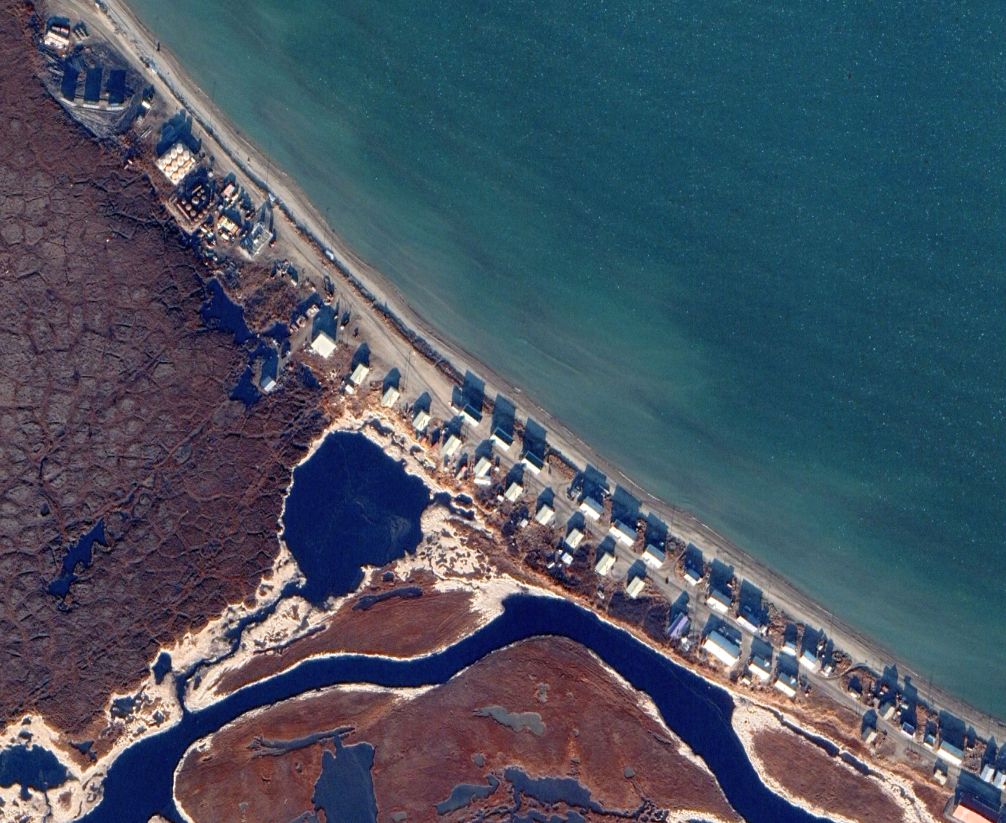
A 2019 aerial view of the site of the original Deering Airport.
Jim Moffett observed, “My guess is that the buildings on the northeast side of the road are post-runway:
The distance from the buildings on the other side to the berm that is probably the high tide marker is right at 100 feet - the nominal width of the runway.”
Thanks to Jim Moffett for pointing out this airfield.
____________________________________________________
Point Spencer Army Airfield/ Point Spencer Air Force Base, Point Spencer, AK
65.277, -166.849 (Northwest of Anchorage, AK)
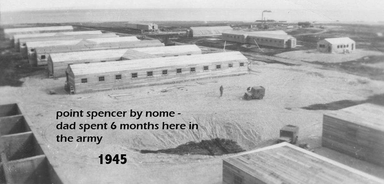
A 1945 photo by John Nerby of the buildings of Point Spencer Army Airfield (courtesy of Mike Nerby).
According to Alex Clark, “During WWII the Army Air Force built an airbase at Point Spencer on the Seward Peninsula of Alaska.”
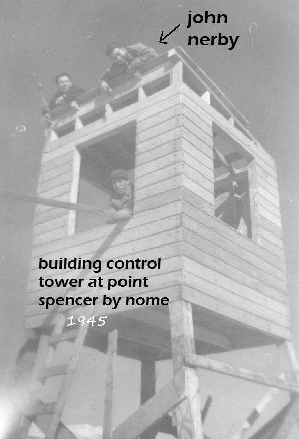
A 1945 photo of John Nerby & others building the control tower for Point Spencer Army Airfield (courtesy of Mike Nerby).
Mike Nerby reported, “My Father (John Nerby) spent 6 months at Point Spencer in 1945.
They lived in tents; they never got to move into the buildings. He was 19.”
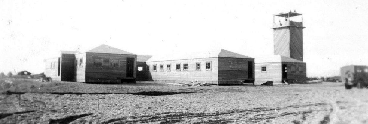
A 1945 photo by John Nerby of the control tower & other buildings of Point Spencer Army Airfield (courtesy of Mike Nerby).
According to Alex Clark, “The airbase at Point Spencer... was closed down around 1948 & mothballed.”
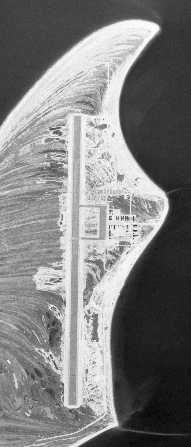
The earliest aerial photo which has been located of Point Spencer AFB was an 8/1/50 USGS aerial view.
It depicted a single paved north/south runway, with a paved ramp & a large number of buildings on the east side.
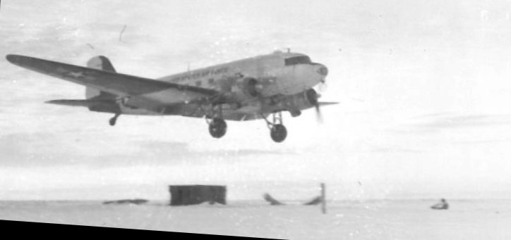
A circa 1950 photo of an Air Force C-47 Skytrain departing Point Spencer AFB
after dropping off an explosives/demolition team headed by Sgt Robert Clark (courtesy of Alex Clark).
According to Alex Clark, “Around 1950 my dad [Sgt Robert Clark] & a team of Army engineers were assigned to the Air Force & ordered to destroy the base as best they could in the middle of winter.
Apparently the top brass decided that the Russians might use it as part of some scheme.
My dad said the shop buildings & hangars were all intact & that there were road graders & cat tractors out there.
So he & his team set up house in a small work shed & installed a couple of pot-belly stoves.
They then started burning up the other building as a fuel source.
My dad's explosives team was out there for awhile & he said one guy went kinda nuts one day
and took off across the 12 miles of ocean ice & headed east towards either Brevig Mission or Teller, saying he needed a drink.
I am not sure if they ever found him.”
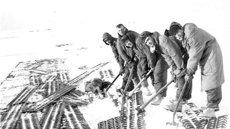
A circa 1950 photo of an Army demolition team ripping up the Point Spencer Pierced Steel Planking runway (courtesy of Alex Clark).
According to Alex Clark, “They blew up the metal pierced plank runway & my dad said they drove most of the equipment out onto the frozen ocean ice
and used TNT blocks to blast the ice open so all the drive-able gear would sink into the water underneath.
When the C-47 eventually came back out to pick them up, he set the timer & the plane dodged the holes in the runway to get airborne.”
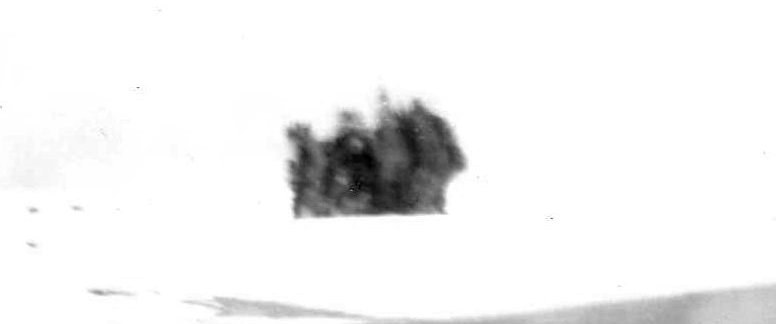
A circa 1950 photo by Army Sgt Robert Clark (courtesy of Alex Clark) of the exploding Point Spencer AFB runway,
taken through the frozen window of an Air Force C-47 Skytrain as the demolition charges went off.
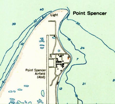
The 1957 USGS topo map depicted “Point Spencer Airfield (Abandoned)” as having a single paved north/south runway, with a paved ramp & a large number of buildings on the east side.
In 1961, a site survey was conducted which would eventually see the construction of the Coast Guard's LORAN Station Port Clarence, just to the south of Point Spencer.
The Port Clarence Coast Guard Station airfield was established in 1963, evidently on the site of Point Spencer AFB.
The Coast Guard's LORAN Station Port Clarence ceased operations in 2010.

A 2025 aerial view looking northwest at the Port Clarence Coast Guard Station airfield, the site of Point Spencer AFB.
Thanks to Alex Clark for pointing out this airfield.
____________________________________________________
Alexai Point Army Airfield, Attu Island, AK
52.816, 173.297 (Southwest of Anchorage, AK)
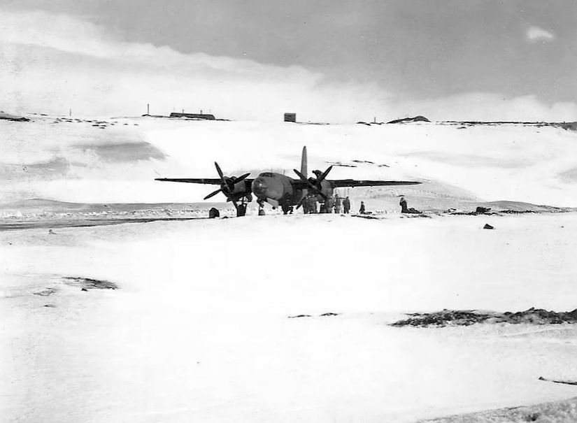
A 1944 photo of a Martin AT-23B Marauder on a snowy Alexai Point Army Airfield.
Attu Island is the westernmost island in the Aleutian Islands of Alaska,
and is significantly closer to mainland Russia than mainland Alaska.
According to Wikipedia, the 301st Independent Infantry Battalion of the Japanese Northern Army landed on Attu Island on 6/7/42, without opposition.
The 42 Attu inhabitants who survived the Japanese invasion were taken to a prison camp near Otaru, Japan, and 16 died during subsequent imprisonment.
American forces eventually returned to Attu on 5/11/43.
The Japanese, who knew the Americans were coming, had pulled back from their shoreline positions & moved to defensive positions on higher ground above the fog.
On 5/30/43, before the battle for Attu was completely over, the building of Alexai Point Airfield was initiated
using Marsden Matting to pave 2 runways on a narrow peninsula on the southeast shore of the island.
The first landing at Alexai Point Airfield was made by an 11th Air Force C-47 arriving on 6/8/43 to deliver fighter crews to Alexai Point & evacuate wounded soldiers.
Shortly afterwards, P-40 Warhawks from the 344th Fighter Squadron arrived to provide air cover over the island.
USAAF units assigned to Alexai Point Army Airfield were: 18th Fighter Squadron, 3/28/44-11/6/45 (P-38 Lightning),
54th Fighter Squadron, 11/20/43-3/8/46 (P-38 Lightning), 344th Fighter Squadron, 6/12/43 - December 1943 (P-40 Warhawk),
77th Bombardment Squadron, July–September 1943; 2/11/44-10/19/45 (B-25 Mitchell, B-26 Marauder).
Alexai Point Army Airfield was intially used for carrying out bombardment operations over Kiska Island during June & July 1943.
After the end of the Aleutian Islands Campaign in late August, Alexai Point & the new Shemya Army Airfield became forward bases for operations against the Kurile Islands of northern Japan.
Alexai Point became home of very long-range (VLR) P-38 Lightning squadrons, providing fighter escort for B-24 Liberators bombers based at Shemya.
By mid-July fighters from Alexai Point Airfield had made their first strike against Japan, a raid against the northern Kuril Islands.
The earliest depictions which have been located of Alexai Point Army Airfield were a series of 1944 photos of a variety of American military aircraft.
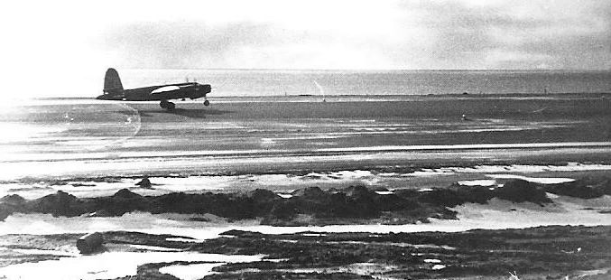
A 1944 photo of a Martin AT-23B Marauder on a Alexai Point Army Airfield runway.
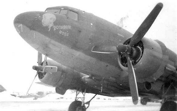
A 1944 photo of a Douglas C-47 Skytrain “Bourbon Nose” at Alexai Point Army Airfield.
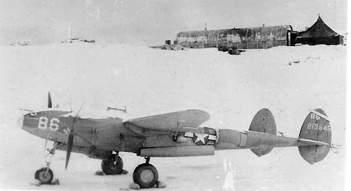
A 1944 photo of a Lockheed P-38 Lightning fighter at a snowy Alexai Point Army Airfield.
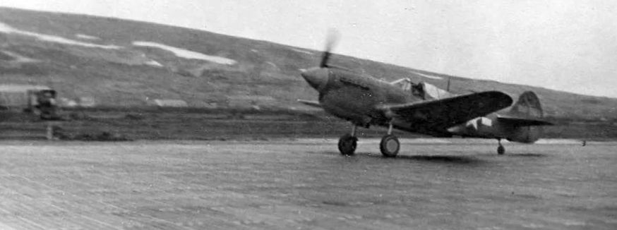
A 1944 photo of a Curtiss P-40 Warhawk fighter on a Alexai Point Army Airfield runway.
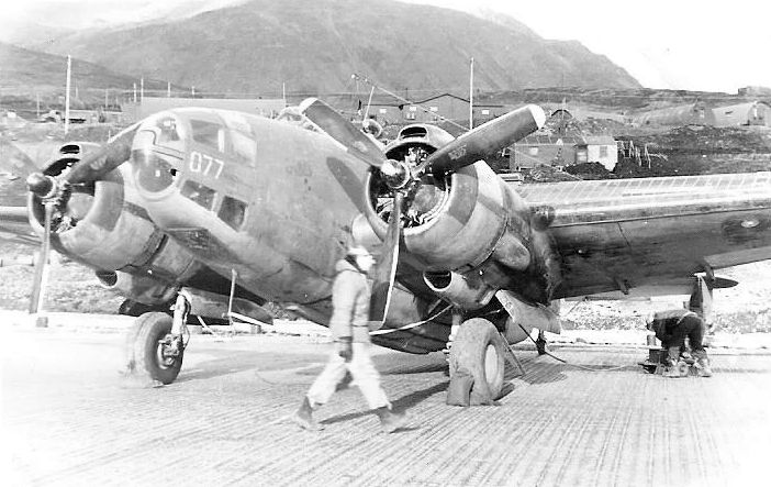
A 1944 photo of a Navy Lockheed PV-1 Ventura bomber on the Marsden Matting of Alexai Point Army Airfield.
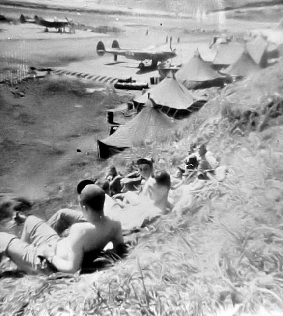
A summer 1943-45 photo of crews relaxing near Lockheed P-38 Lightnings at Alexai Point Army Airfield.

A summer 1943-45 photo of a crew with their Lockheed P-38 Lightning fighter on the Marsden Matting of Alexai Point Army Airfield.
With the end of the war in 1945, combat units were gradually withdrawn from Alexai Point Army Airfield.
The 11th Weather Squadron & the 713th Air Warning Radar Squadron remained until June 1946 when the base was closed.
The facility was abandoned, with most structures dismantled, the usable buildings being reassembled at Naval Air Station Attu.
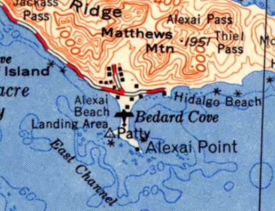
The 1952 USGS topo map depicted Alexai Point Army Airfield simply as a “Landing Area”.
The March 2006 Western Aleutian Islands Sectional Chart (courtesy of Stu Sibitzky) no longer depicted Alexai Point Army Airfield.
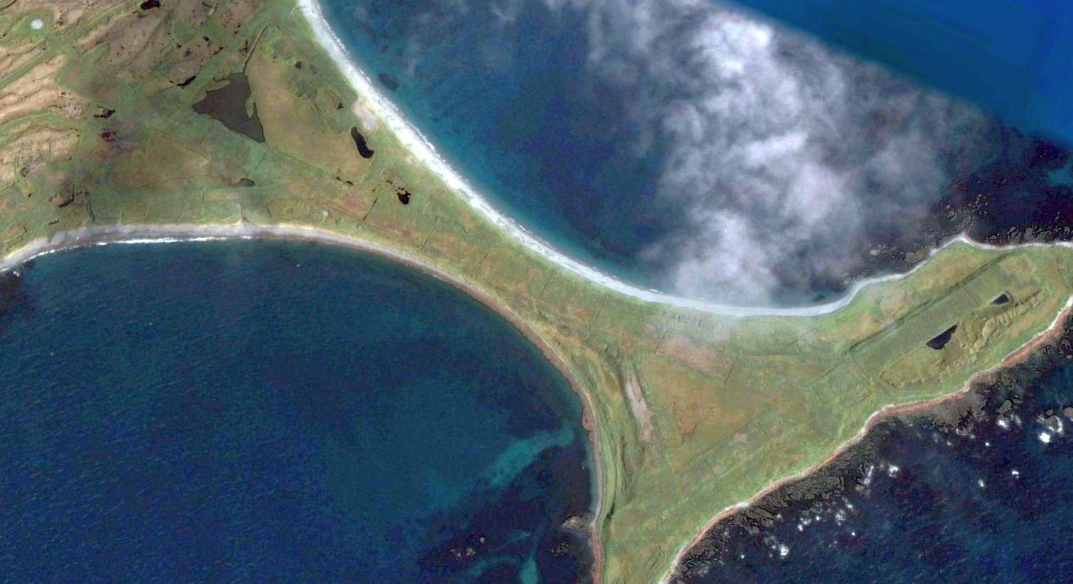
A 2006 aerial view looking northeast shows the 2 runways & taxiways of Alexai Point Army Airfield were still very recognizable.
Other remains include revetments, roads, and anti-aircraft gun emplacements.
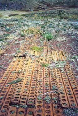
A 2006 photo of the Marsden Matting which remains at the site of Alexai Point Army Airfield.

A 2024 aerial view looking northeast shows the 2 runways of Alexai Point Army Airfield were still very recognizable, 78 years after being abandoned.
____________________________________________________
Shishmaref Airport (original location), Shishmaref, AK
66.256, -166.058 (Northwest of Anchorage, AK)
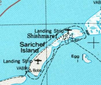
The original location of Shishmaref Airport (the “Landing Strip” on the northeast part of the island), as depicted on the 1950 USGS topo map.
Located on the small island of Sarichef off the coast of Alaska near the Arctic circle, only 87 NM from mainland Siberia,
the tiny village of Shishmaref is a century-old Inupiat Eskimo village whose economy depends partly on subsistence fishing & hunting.
The date of establishment of Shishmaref's original airport has not been determined.
The earliest depiction which has been located of Shishmaref Airport was on the 1950 USGS topo map.
It depicted a “Landing Strip” on the northeast part of the island, along with another Landing Strip on the southwest part of the island.
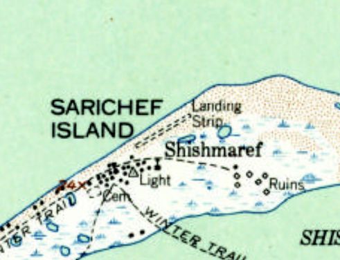
The 1957 USGS topo map depicted the original Shishmaref Airport as a single unpaved northeast/southwest runway, generically labeled as “Landing Strip”.
At some point between 1950-2000, Shishmaref's original airport had to be closed due to erosion.
The original airport's north/south runway ran across the narrow width (only 2,000') of the island, but too much land was lost to maintain a long enough runway.
Climate change had caused the Chukchi Sea, which surrounds the island, not to freeze before the arrival of the fierce fall storms, as it had for centuries, leaving the island unprotected.
In the decade before the airport's closure, hundreds of feet of shore as well as several houses had been lost to the storms.
A new Shishmaref Airport was built less than a half-mile to the southwest, but aligning the new airport's runway with the island's predominant southwest/northeast axis
put the runway perpendicular to the prevailing winds, causing it to have a direct crosswind during most flight operations.
Only the new Shishmaref Airport was depicted on the July 2000 Nome Sectional Chart (courtesy of Stu Sibitzky).
After closure of the original Shishmaref Airport, houses were subsequently built on the former runway.
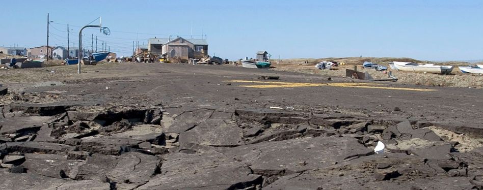
A circa 2005-2016 photo of the runway remains of the original Shishmaref Airport, showing a closed-runway “X” symbol,
and the broken-up pavement due to the shoreline erosion which closed the airport.
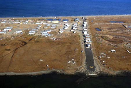
A circa 2005-2016 aerial view looking north along the runway remains of the original Shishmaref Airport, with a closed-runway yellow “X” on the end.
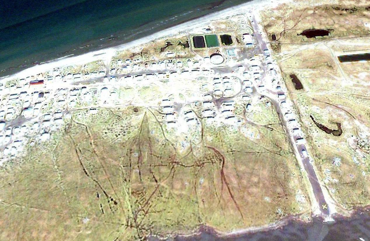
A 2008 aerial view looking north at the remains of the original Shishmaref Airport, showing a closed-runway “X” symbol on the southern end of the former runway.
The village of Shishmaref will eventually have to be evacuated within the next few years if the shoreline erosion continues.
____________________________________________________
Ogliuga Army Airfield, Ogliuga Island, AK
51.606, -178.656 (Southwest of Anchorage, AK)
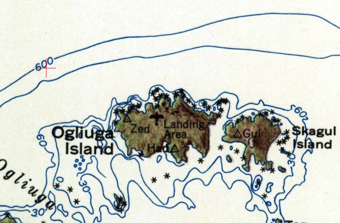
Ogliuga Island AAF was labeled as a “Landing Area” on the 1951 USGS topo map.
Photo of the airfield while in use has not been located.
Ogliuga Island is located at the far western end of the Aleutian Island chain, being located closer to mainland Russia than mainland Alaska.
According to Wikipedia, “Ogliuga Island AAF was established in 1942 as a result of the Japanese invasion of the Aleutian Islands.
Its primary use was as an emergency landing field by USAAF & Naval Air aircraft during the campaign, not having any permanent units assigned.”
According to the U.S. Navy's “Building the Navy's Bases in World War II', “Construction of the emergency landing field
established at Ogliuga for the Army in July 1943, was performed entirely by Seabees.
A 3,000' x 100' runway & four 100'-square parking areas were constructed, with a surface of steel matting.
The only other construction at Ogliuga was a small building for living quarters.”
It has not been determined if Ogliuga Island AAF was ever actually used by any aircraft.
According to Wikipedia, Ogliuga Island AAF “was abandoned after World War II.”
The earliest depiction which has been located of Ogliuga Island AAF was on the 1951 USGS topo map, which labeled it simply as “Landing Area”.
The March 2006 Western Aleutian Islands Sectional Chart (courtesy of Stu Sibitzky) no longer depicted Ogliuga Island AAF.
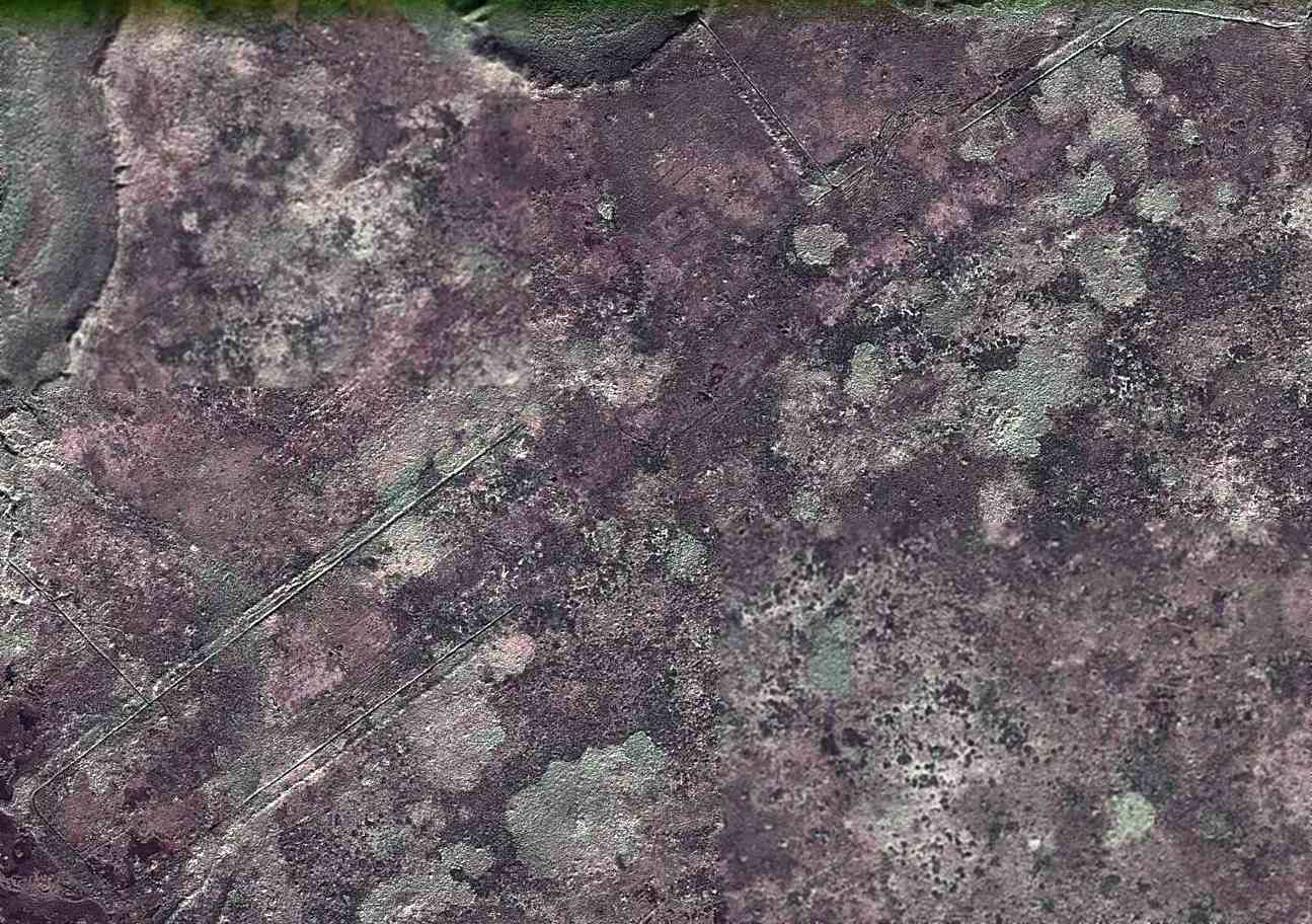
A 2010 aerial photo depicted the remains of a northeast/southwest runway at the site of Ogliuga Island Army Airfield.
According to Wikipedia, “Only some foundations of buildings & the remnants of 2 runways remain.”
Thanks to John Voss for pointing out this airfield.
____________________________________________________
Amchitka Army Airfield / Naval Air Facility Amchitka / Amchitka Air Force Base, Amchitka Island, AK
51.38, 179.27 (Southwest of Anchorage, AK)
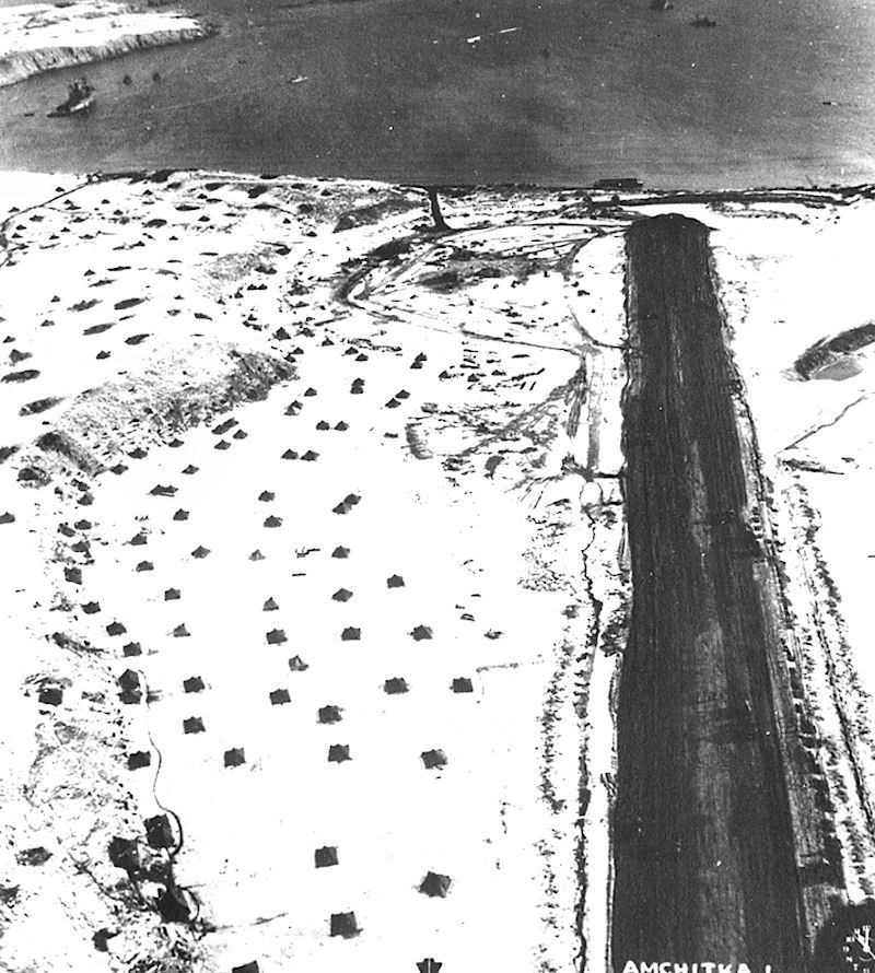
A 3/3/43 aerial view looking east along the Amchitka AAF runway, with personnel tents on the snowy hill to the north of the runway.
According to Wikipedia, American forces made an initially unopposed landing on Amchitka Island on 1/12/43.
Despite facing difficult weather conditions and continual bombing attacks from the Japanese, Army engineers managed to build a runway.
As more troops were landed, heavy construction equipment was brought ashore.
Frozen lakes were drained & the gravel scraped from their beds was used to lay down the bed for a runway.
On 2/16/43 the construction of the first runway at Amchitka (Code Name A-3, oriented east/west) had progressed to the point where light fighters could be brought in.
This airfield was also known as “Fox”, according to the University of AK Fairbanks.
Eighteenth Fighter Squadron Curtis P-40 Warhawks began to arrive from Adak & surprised the Japanese by launching counter-attacks to their raids from Kiska.
Two Japanese light bombers were shot down over the airfield in full view of the construction engineers.
In addition to the P-40s, several Lockheed P-38 Lightnings arrived.
To the north of the main World War II runway were constructed a large number of roads & Quonset huts, and possible temporary aircraft maintenance hangars.
To the south of the main World War II runway were constructed numerous taxiways & a large number of aircraft revetments, likely dating from the Aleutian Campaign.
The aircraft parking was dispersed over a wide area almost to the south shore of the island connected by a taxiway & road network.
As the airfield was attacked on several occasions by Japanese aircraft, the wide dispersal was needed for defense.
Also constructed were a large number of anti-aircraft artillery sites, ammo dumps & other facilities.
The adverse weather conditions included much fog & this caused the loss of many aircraft.
To counter this Fog Investigation & Dispersal Operation (FIDO) was installed on runway Baker (the bomber runway) and it became operational in mid-June 1944.
It was used on several occasions, allowing successful take-off & landing in foggy conditions that would otherwise have prevented safe operations.
With its establishment, the Alaska Command was now 50 miles away from their target, Kiska.
The military eventually built numerous buildings, roads, and a total of 3 airstrips on the island.
At its peak, the occupancy of Amchitka Army Airfield reached 15,000 troops.
Known USAAF units assigned to Amchitka AAF were:
HQ IX Bomber Command, 6/24-9/4/43, HQ 343rd Fighter Group,
7/25/43–1/22/44, 11th Fighter Squadron, 3/27-5/17/43 & 3/23/44-July 1945 (P-40 Warhawk),
18th Fighter Squadron, 2/15/43-3/28/44 (P-40 Warhawk & P-38 Lightning),
54th Fighter Squadron, 3/12-10/18/43 (P-38 Lightning),
344th Fighter Squadron, May-July 1943 (P-40 Warhawk & P-38 Lightning),
632rd Bombardment Squadron (Dive), 7/19-8/1543 (A-24 Banshee),
633rd Bombardment Squadron (Dive), 7/19-8/15/43 (A-24 Banshee),
635th Bombardment Squadron (Dive), 7/19-8/15/43 (A-24 Banshee),
21st Bombardment Squadron, 2/18 - July 1943 (LB-30 & B-24 Liberator),
36th Bombardment Squadron, 5/4-9/13/43 (B-24 Liberator),
73rd Bombardment Squadron, March–April 1943; 6/30 - August 1943 (B-25 Mitchell & B-26 Marauder),
77th Bombardment Squadron, 9/11/43-2/11/44 (B-25 Mitchell & B-26 Marauder),
404th Bombardment Squadron, 6/4/43-2/26/44 (B-24 Liberator).
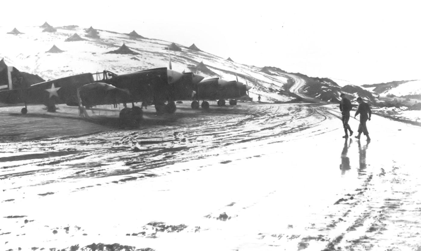
The earliest photo which has been located showing aircraft at Amchitka AAF was a March 1943 photo of 18th Fighter Squadron Curtis P-40s, with personnel tents on the snowy hill to the north of the aircraft.
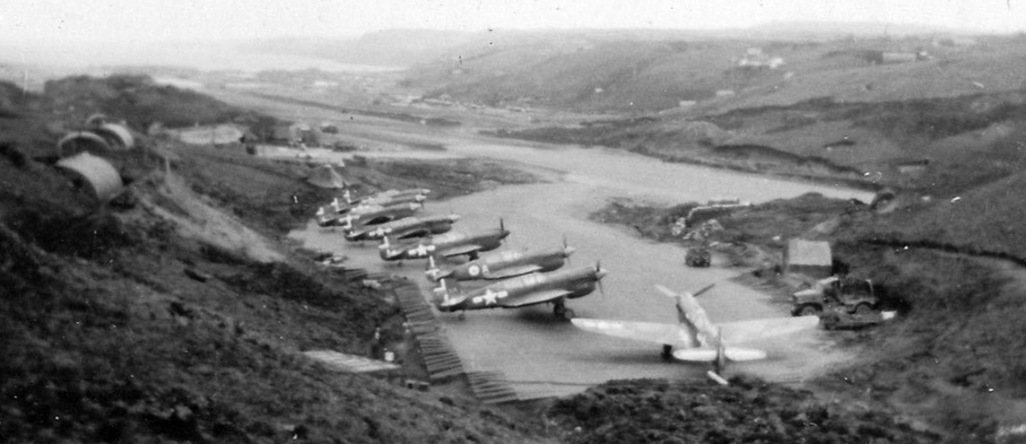
A circa 1943 aerial view looking east at Amchitka AAF showing 8 Curtiss P-40 Warhawks (courtesy of John Voss).
Note the 3rd P-40 from the front is a P-40K from the Royal Canadian Air Force's 111 Squadron.
With the establishment of an American base on Amchitka, the Japanese forces on Kiska Island were put into an untenable situation.
The Battle of the Komandorski Islands, fought on 3/27/43, sealed their fate.
The Japanese, in an attempt to reinforce & resupply their garrison on Attu had dispatched 3 transports which were escorted by 9 warships.
The Japanese commander lost his nerve when he feared American bombers on Amchitka, based on intercepted American radio signals, were preparing to attack.
He ordered his fleet to return to Japan. However, his fears proved groundless as the American aircraft were being prepared for a raid on Kiska island.
Without unloading the bombers & adding external tanks, the 73rd Bombardment Squadron B-25 Mitchells & B-26 Marauders on Amchitka
would have insufficient range to attack the Japanese in the battle area.
This amounted to a strategic defeat, as it ended Japanese attempts to resupply the Aleutian garrisons.
The Americans had essentially isolated the Japanese forces in the Aleutians & their days were numbered.
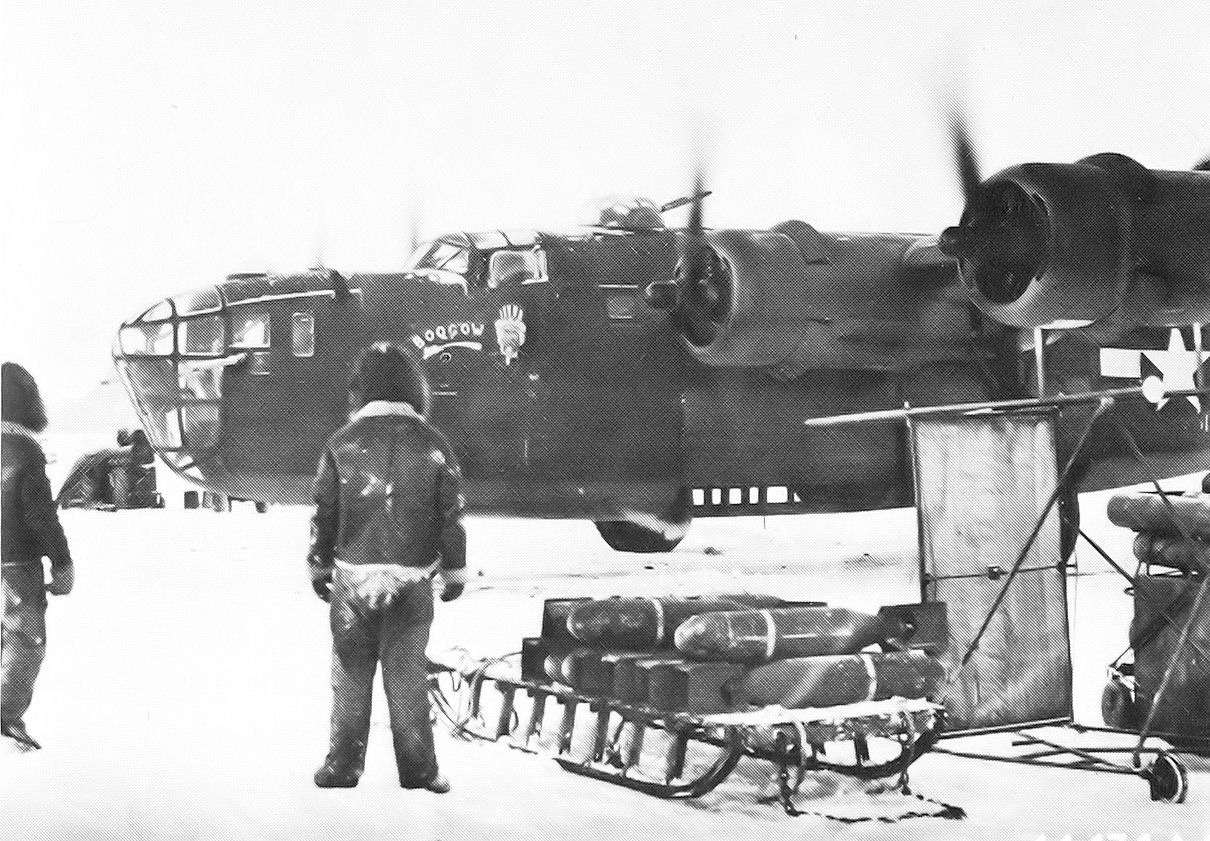
A March 1943 photo of sleds being used to transport bombs to a 21st Bomb Squadron B-24 Liberators at Amchitka AAF.
From its bases on Amchitka, 11th Air Force conducted continual bombing raids on the Japanese on Kiska & Attu.
Long-range B-24 Liberator heavy bombers were moved down from mainland Alaskan bases to operate in the Aleutians
which enabled Air Force commanders to send the bombers with full loads to Attu,
while the B-25 & B-26 medium bombers attacked Kiska several times each day.
Between April 1 & May 11, the 11th Air Force bombers & fighters reached its highest peak of operational activity during its bombing campaign.
Most attacks were directed against Kiska because of Attu being weathered in.
The close proximity of Amchitka allowed the fighters to participate in the attacks & run low-level sweeps over the Japanese positioned on Kiska.
P-38 Lightnings also carried two 500 pound or occasionally one 1,000 pound bomb
and employing glide-bombing tactics went after specific targets such as hangars & fuel tanks; the B-24 bombers dropped their loads on wide-area targets.
Fighters also carried out attacks using 20 pound fragmentation & incendiary bombs.
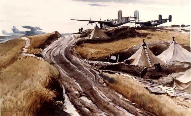
A painting of a WW2 scene of B-24 Liberator bombers & PBY Catalinas at Amchitka AAF.
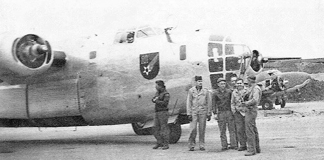
A circa 1943-45 photo by Ray Pell (courtesy of Doug Pell) of a crew in front of a Consolidated B-24 Liberator bomber & a Lockheed Lodestar at Amchitka AAF.
Doug Pell reported that his father was a Link Trainer instructor at Amchitka.
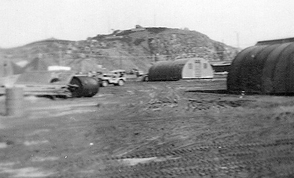
A circa 1943-45 photo by Ray Pell (courtesy of Doug Pell) of huts at Amchitka AAF.
Air support for the Battle of Attu, which took place from 5/11-5/30/43 was carried out from Amchitka.
The battle, which lasted for more than 2 weeks, ended when most of the Japanese defenders were killed in brutal hand-to-hand combat after a final banzai charge broke through American lines.
Air attacks on the Japanese on Kiska continued from Amchitka, with the culmination being the unopposed United States landing on Kiska on August 15.
The Aleutian Islands campaign was successfully completed on 8/24/43. In that month, a strategic intercept station was established on the island.
Jared Gaston reported, “My grandfather (Melton 'Curly' Gaston) was with Torpedo Field Unit #50 at Amchitka servicing torpedoes for the Venturas & PBY Catalinas.
Field Torpedo Unit #50 (renamed from Field Torpedo Unit #14) transferred from NOB Adak to Amchitka on 11/24/43, arriving on the 28th via the Seaplane Tender USS Teal.
Field Torpedo Unit #50 muster rolls show these men in the unit while at NAF Amchitka:
S1c John Borden Anderson, TM2 Fletcher Chapman, TM2 Stephen Comstock, MoMM1 John De Vore, TM1 Quinton Finley, TM2 Melton Gaston, TM2 John Linderer, MoMM1 Franklyn Miller, CTM Gordan Duncan.
My grandfather left on 12/21/44 with only 3 other members of the unit, so I assume the unit remained stationed there for some time after that date.”
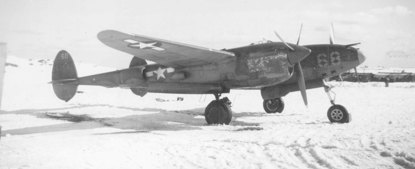
A WW2 photo of an Army Air Forces Lockheed P-38 Lightning fighter at Amchitka AAF (courtesy of John Voss).
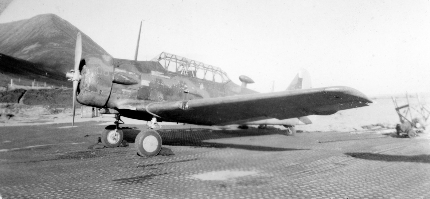
A WW2 photo of a very weather-worn looking North American T-6 Texan trainer at Amchitka AAF (courtesy of John Voss).
What would a trainer have been doing at such a remote location?

A 1943 photo of a Navy Consolidated PBY patrol amphibian (loaded with 2 bombs underwing) at Amchitka AAF (courtesy of John Voss).
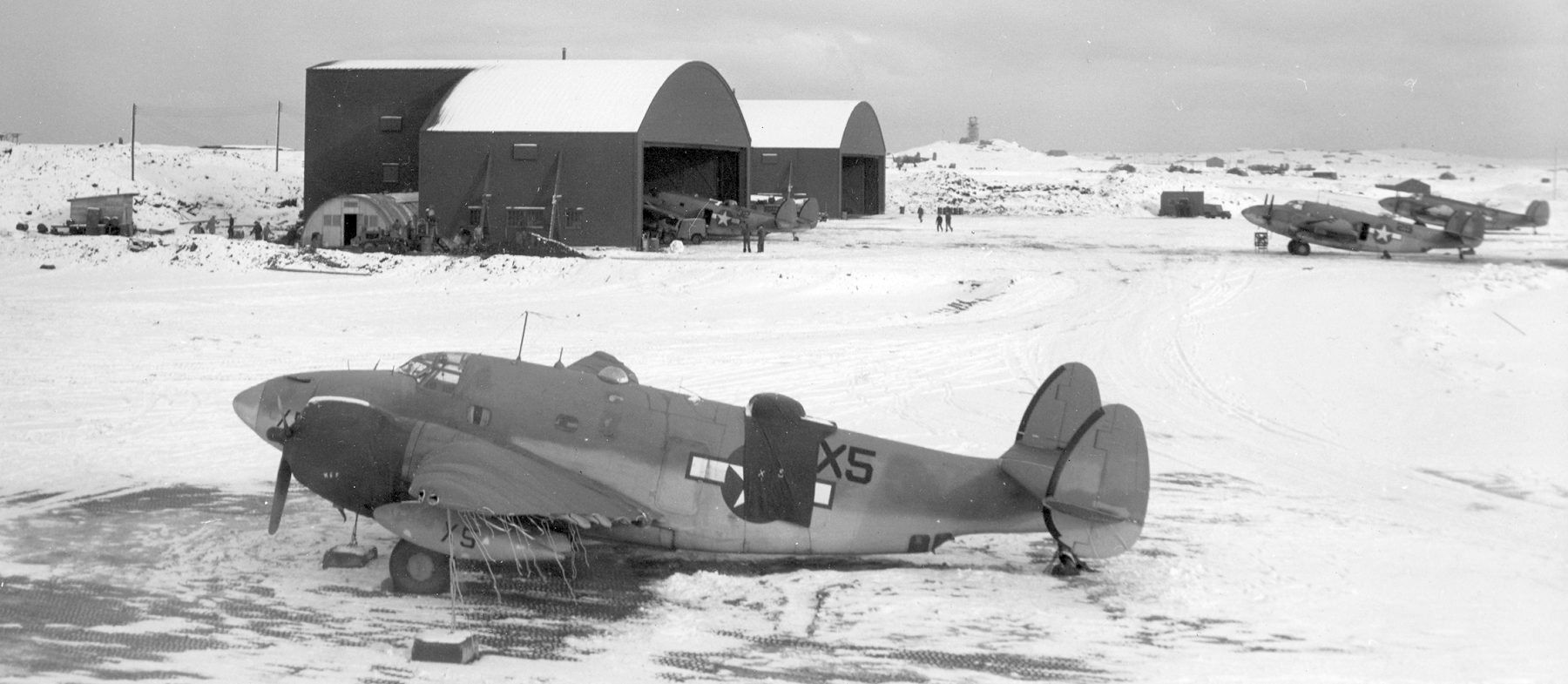
A 12/7/43 photo of 4 Navy Lockheed PV-1 Ventura patrol bombers in front of 2 hangars at Amchitka AAF (courtesy of John Voss).
Most combat squadrons were withdrawn by early 1944, the 11th Fighter Squadron becoming the headquarters garrison of the base until the end of the war.
The mission of Amchitka AAB was that of a communications facility
and also refueling for support & combat aircraft headed to & from Alexai Point Army Airfield on Attu & Shemya Army Airfield.
Amchitka's strategic intercept station remained in operation until February 1945.
On 7/1/47 the Aleutian Section of Alaskan Air Command was inactivated & Amchitka AAF was reassigned to Strategic Air Command.
Under SAC control, the field's mission was to provide refueling to SAC long range aircraft
and to Air Transport Command cargo flights between Japan & the Continental United States.
The base also compiled data by the 11th Weaather Squadron, Air Weather Service, and assisted in Air Rescue & Recovery missions.
The base had one C-47 permanently assigned.
The main World War II runway (7/23) was extended to 8,000' by SAC after WW2 to accommodate B-29s & MATS intercontinental transports.
A 6,000' secondary north/south runway was later constructed to the east,
and to the east of the runway were a series of personnel billeting or aircraft technical sites, and a possible port facility.
SAC or MATS received funding for a third 7,000' northeast/southwest runway to the north side of the main airfield at some point after WW2.
According to the University of AK Fairbanks, Amchitka's 2nd & 3rd runways were designated "Charlie" & "Baker",
and as of the late late 1940s runway "Charlie" was at that time the world's longest runway, at 10,000'.
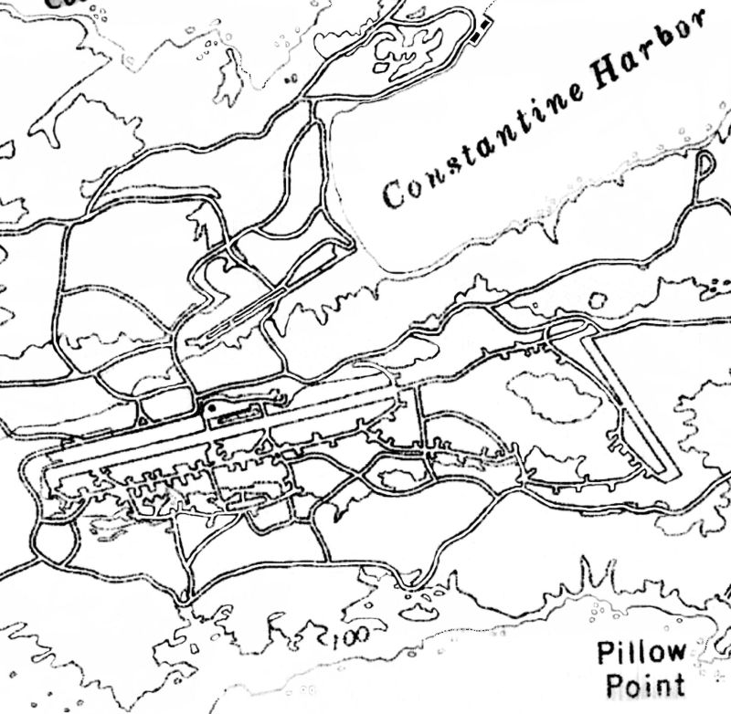
An undated topo map depicted all 3 Amchitka military runways, along with their extensive network of taxiways & aircraft revetments.
Amchitka was redesignated Amchitka Air Force Base with the establishment of the United States Air Force in September 1947.
The facilities of the postwar SAC / MATS Amchitka Air Force Base were largely north of the 3rd runway.
SAC Operations ceased at Amchitka in February 1949 when the base was put into a caretaker status.
On 12/31/49 the base was closed due to insufficient personnel & staff.
The Army closed its communications facility at Amchitka in August 1950.
On 12/31/50 the 2107th Air Weather Group pulled the last of its personnel out of Amchitka & the facility was abandoned.
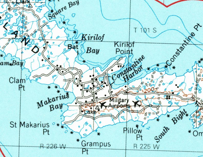
The 1951 USGS topo map depicted 2 “Military Airports” at Amchitka.
Amchitka hosted an Air Force White Alice telecommunication system in 1959-61, built on Kirolof Point to the north of the airfield.
Amchitka also hosted a temporary relay station in the 1960s & 1970s.
In the mid-1960s, the Atomic Energy Commission (AEC) used Amchitka for a series of underground nuclear tests.
New facilities were built in the 1960s by the AEC, which also reused the old AFB as its main base station.
In the 1960s a new 5,000' Runway 1/19 was constructed a few miles to the northwest of the WW2 airfield,
and the #3 Air Force runway was refurbished.
The AEC built a series of roads, base camp facilities and support buildings for the nuclear workers over the south part of the island in a similar manner to the Nevada Test Site.
A total of 3 nuclear tests, Long Shot, (1965), Milrow (1969), and Cannikin (1971) were performed.
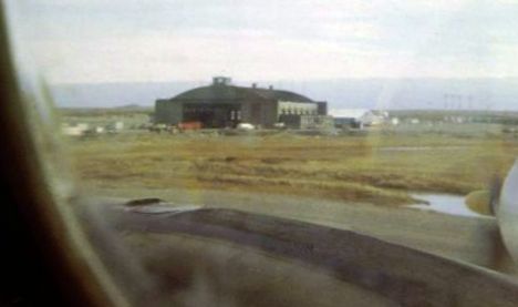
A September 1967 photo by 7th MAS Lodemaster Alan Young of Amchitka's Passenger/Cargo Terminal.
The AEC withdrew from Amchitka in 1973 & their facilities were abandoned.
A sign for Amchitka Airport & an adjacent aircraft propeller relic was placed near the Amchitka air terminal by Jim Coffey,
who recalled, “We were stationed on Amchitka with the Aleutian Island National Wildlife Refuge. I was the Maintenance Engineer there from 1975-78.
At that time there was a population of 6 on the island year round & my family made up 3 of the 6.
We were the first inhabitances to reoccupy the island after the AEC abandoned the site.”
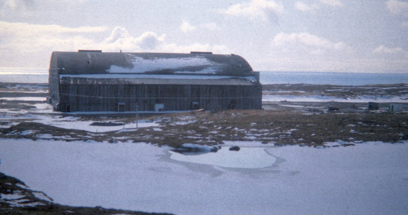
A 1979 photo of Amchitka's South Hangar, located on the south side of the main east/west runway.

The last photo which has been located of an aircraft ay Amchitka was a 1979 photo of a Reeve Aleutian Airlines Lockheed Electra.
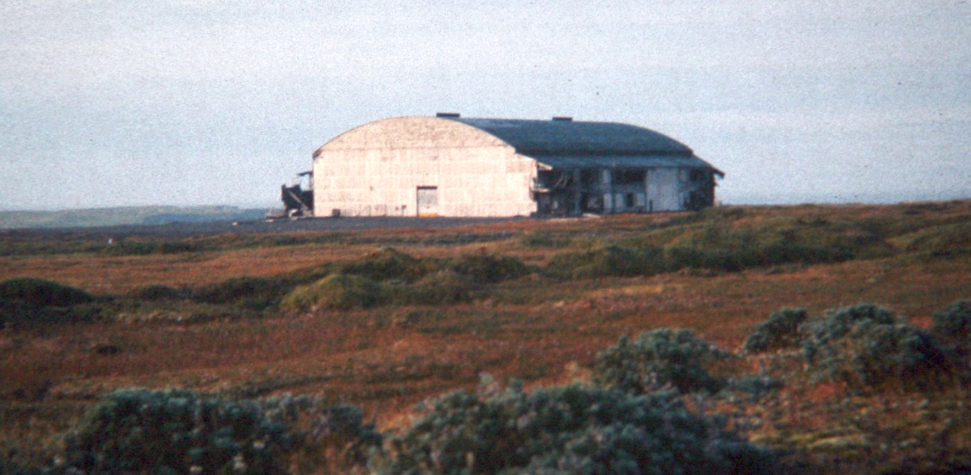
A 1979 photo of Amchitka's North Hangar, located on the north side of the main east/west runway.
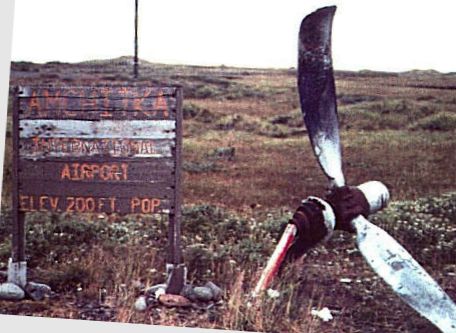
A 1980s photo by D. Hutchinson of the sign for Amchitka Airport & an adjacent aircraft propeller relic, located near the air terminal.
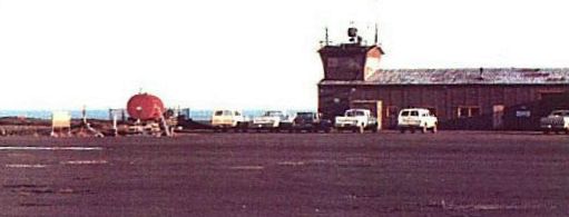
A 1980s photo by D. Hutchinson of the Amchitka Air Terminal showing a control tower cab on top of a hangar.
Note the airport sign & propeller (shown in preceding photo), visible to the left of the red fuel tank.
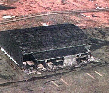
A 1980s aerial view of Amchitka's North hangar, which has since been demolished.
The March 2006 Western Aleutian Islands Sectional Chart (courtesy of Stu Sibitzky) depicted Amchitka AAF/AFB as an abandoned airfield.
As of 2015, Amchitka Air Force Base is largely intact, although abandoned in most part for the past 60 years.
Runways, taxiways, aircraft parking dispersal revetments remain along with a large support base with deteriorating buildings.
Due to its remote location, it rests undisturbed with ice & snow covering the base most of the year, exposed to the elements in the short summers.
It is almost constantly under a cloud cover & fog generally obscures the area.
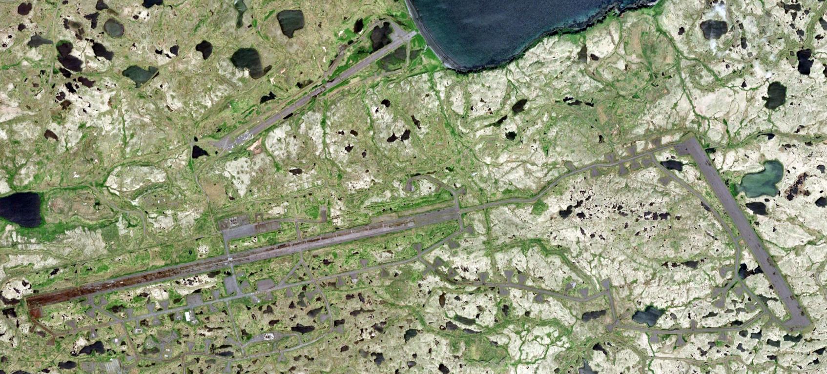
A 7/11/18 aerial view of the remains of the 3 Amchitka AAF/AFB runways.
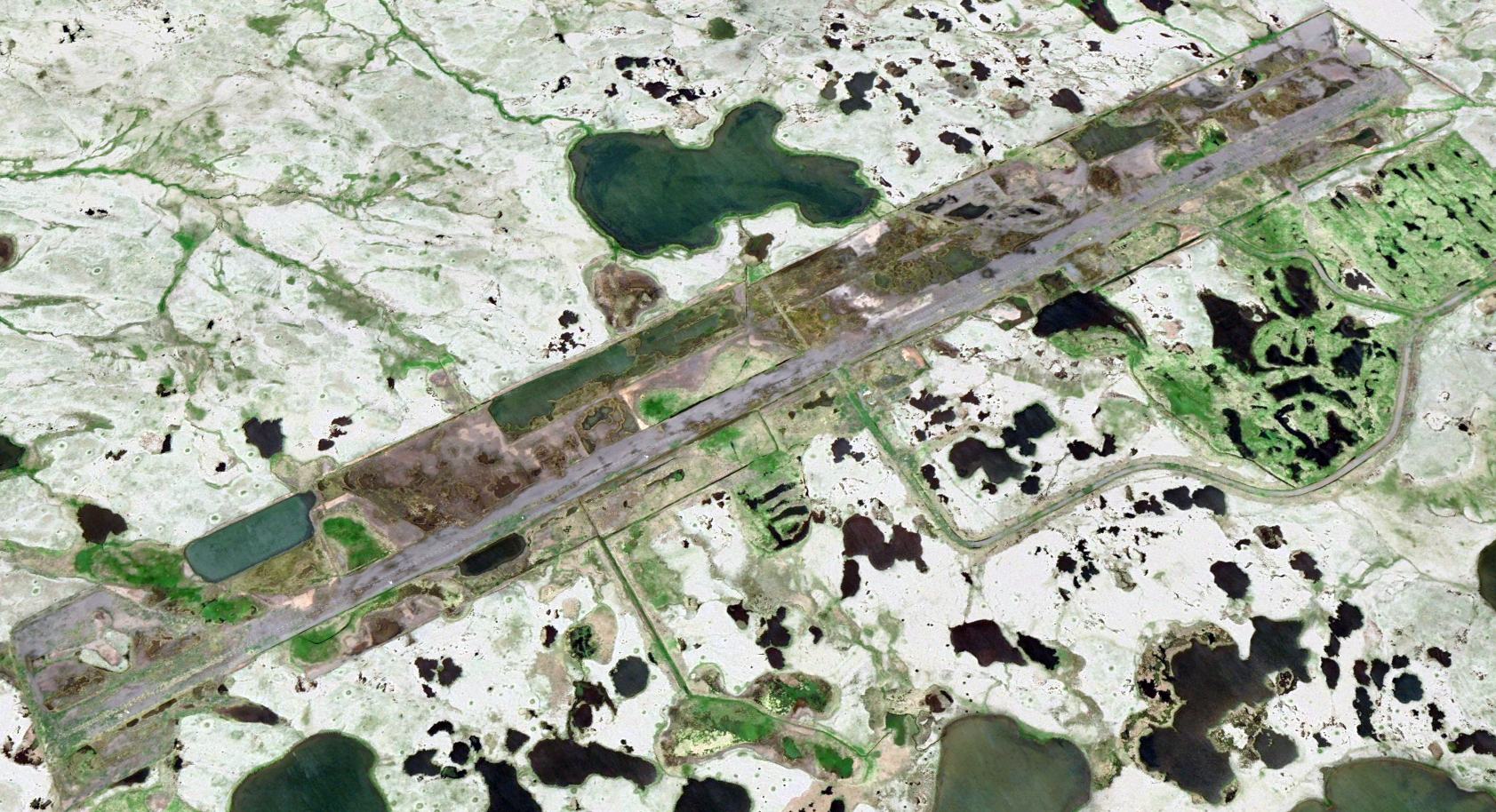
A 7/11/18 aerial view looking northwest at the remains of the Amchitka AEC runway, northwest of the Amchitka AAF/AFB remains.
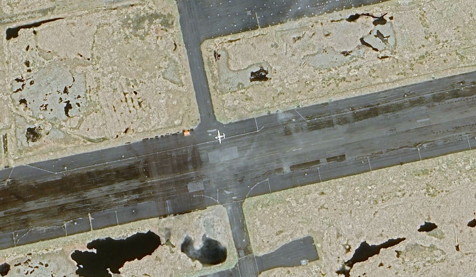
A 6/3/24 aerial view (courtesy of Daryl Greaser) showed a light twin-engine aircraft (possibly a Piper Navajo operated by Martin Air) on Amchitka's main runway.
Daryl reported that contractors are there doing environmental remediation, and there is equipment present on the northern runway not seen in earlier images.
The remnants of the Amchitka AEC facilities are visible over a wide area, generally north of the former AFB.
The Department of Energy continues to monitor the site as part of their remediation program.
This is expected to continue until 2025, after which the site is intended to become a restricted-access wildlife preserve.
Thanks to Bill Grasha for pointing out this airfield.
____________________________________________________
Western Shemya Army Airfield, Shemya Island, AK
52.72, 174.08 (Southwest of Anchorage, AK)
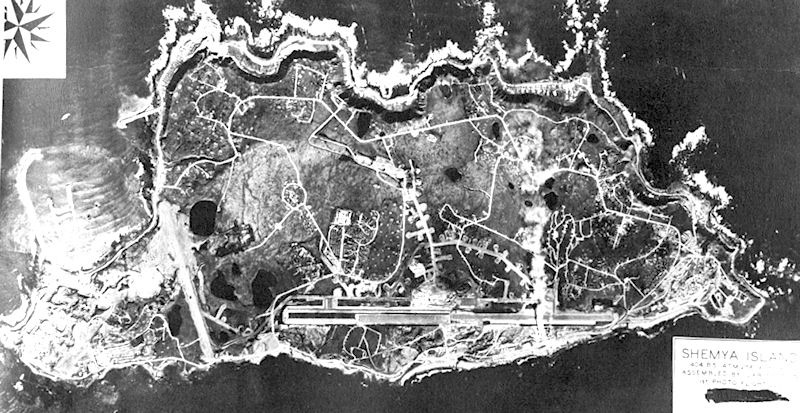
A 1944 aerial view depicted one north/south runway on the western end of Shemya, in addition to the primary airfield on the eastern end.
Shemya Island is one of the western-most American islands of the Aluetian Island chain, being located closer to mainland Russia (438 NM) than mainland Alaska.
On 5/28/43, a small detachment of Alaskan Scouts began reconnaissance of Shemya.
The following day, United States Army Engineers came ashore to begin construction of a runway suitable for B-29 Superfortress bombers.
Tents were erected, a rudimentary electrical system, radios and some rough streets were laid down.
A 10,000' east/west runway was constructed on the eastern portion of the island, along with a 5,000' north/south runway on the western portion.
A wide variety of aircraft flew from Shemya during WW2, but it is presumed the majority of these operated from the primary airfield on the eastern end of the island.
It is not known what specific purpose the western airfield served,
other than presumably serving smaller aircraft (fighters), leaving bombers to the larger airfield on the east end of the island.
Dick Morris reported, “Brutal weather conditions, including winds over 100 MPH & zero visibility due to snow & fog are common.
The shorter runways may have been maintained for when the main runway experienced high crosswinds.”
With the exception of a small station housekeeping unit, Shemya was abandoned after WW2.
The island was littered with abandoned Army & Navy aircraft wrecks & deteriorating station structures.
Abandoned vehicles, warehouse stores of all types, rations, clothing & all the other tools of war, including ammunition & bombs were simply left out to the elements.
For a time the Air Force considered transferring the island to the Civil Aeronautics Administration.
However, the Air Force decided to retain Shemya because its location provided an ideal refueling stop on the Great Circle Route from Japan to Washington State.
The earliest depiction which has been located of the western Shemya airfield was a 1944 aerial view,
which depicted one north/south runway on the western part of the island, along with the much longer east/west runway on the eastern part of the island.
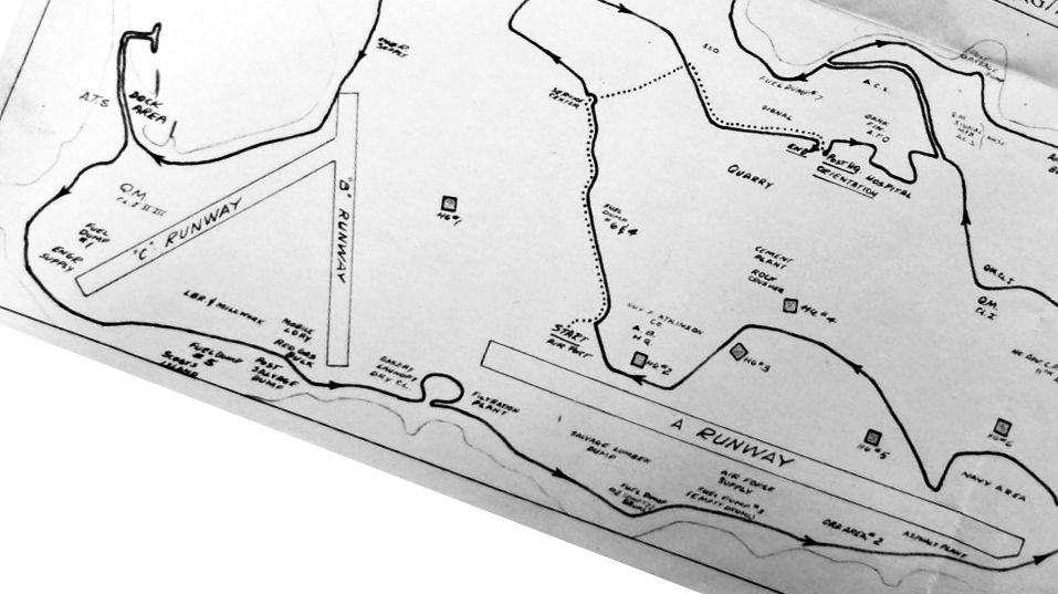
A circa 1945 map of the western end of Shemya (from the National Archives College Park, courtesy of Ron Plante)
depicted “B Runway” & “C Runway” on the western end, along with the much longer “A Runway” to the east.
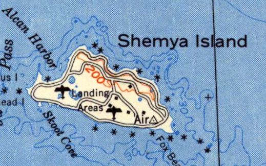
The 1952 USGS topo map simply depicted 2 “Landing Areas” on Shemya Island.
The March 2006 Western Aleutian Islands Sectional Chart (courtesy of Stu Sibitzky) no longer depicted the Western Shemya Island Airfield.
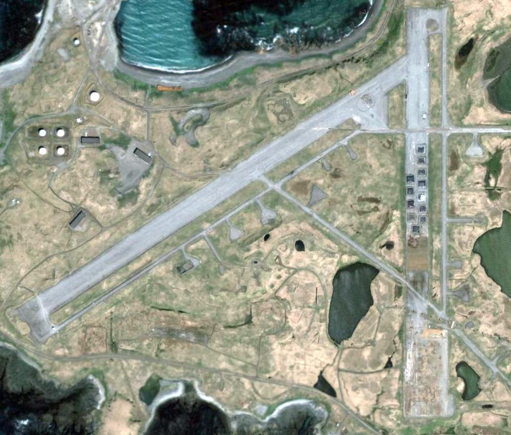
A 2006 aerial view showed the northeast/southwest runway on the west end of Shemya remained intact,
while the southern half of the north/south runway had been removed, and unidentified objects had been placed over the northern half.
____________________________________________________
Fort Randall Army Airfield Satellite Field, Cold Bay, AK
55.176, -162.646 (Northwest of Anchorage, AK)
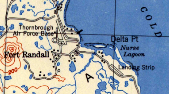
The 1949 USGS topo map depicted both Thornbrough AFB & its “Landing Strip” to the southeast.
Fort Randall Army Airfield was constructed during World War II during the secret military buildup of the Territory of Alaska that began in 1941.
Disguised as civilian employees of the Blair Canning & Packing Company, United States Army personnel in civilian clothes were shipped to Cold Bay.
Construction began in December 1941, and the airfield was ready for operation by March 1942.
The primary airfield had two 5,000' asphalt runways,
and 2 miles to the southeast was a separate satellite field with a single 5,000' gravel northwest/southeast runway.
It is not known what use (if any) the satellite airfield served.
Known units assigned to Fort Randall Army Airfield were: 1942-43: 73rd Bombardment Squadron, 1942-43: 344th Fighter Squadron,
June–July 1942: 54th Fighter Squadron, May–September 1942: 11th Fighter Squadron.
Fort Randall Army was redesignated to a Naval Auxiliary Air Facility on 4/1/43.
A 2-gun 152mm naval gun battery was located at Grant Point (one gun remains on display near the town dump).
A 4-gun 155mm gun battery on Panama mounts was located at Mortensen's Lagoon at Thin Point.
In the spring & summer of 1945, Cold Bay was the site of the largest & most ambitious transfer program of World War II,
Project Hula, in which the United States transferred 149 ships & craft to the Soviet Union
and trained 12,000 Soviet personnel in their operation in anticipation of the Soviet Union entering the war against Japan.
Fort Randall provided housing & classroom space for the instructors & trainees.
At any given time, about 1,500 American personnel were at Cold Bay & Fort Randall during Project Hula.
The installation at Cold Bay was renamed Thornbrough Air Force Base in 1948 for Captain George Thornbrough,
a U.S. Army Air Forces B-26 Marauder pilot.
Captain Thornbrough fought during the Battle of Dutch Harbor in June 1942,
bravely attacking a Japanese aircraft carrier that was launching strike aircraft at Dutch Harbor.
Although his torpedo struck the carrier, it failed to explode.
Captain Thornbrough returned to his airfield to refuel & rearm & then took off to rejoin the fight.
The aircraft & entire crew were lost during their return from this mission, when they were unable to land at Cold Bay.
The wreckage of Captain Thornbrough's aircraft was found 50 miles from Cold Bay on the north side of the Alaska Peninsula the following month.
The earliest depiction which has been located of the satellite field was on the 1949 USGS topo map,
which depicted a single northwest/southeast “Landing Strip” to the southeast of Thornbrough AFB.
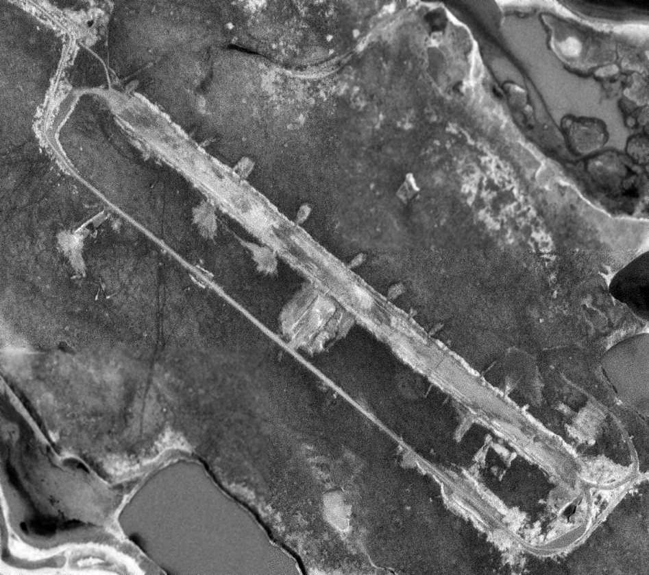
The earliest photo which has been located of the Cold Bay satellite field was a 6/22/73 USGS aerial view.
It depicted a single northwest/southeast runway, heavily deteriorated, with the remains of numerous dispersal parking pads on both sides of the runway.
The February 1997 Cold Bay Sectional Chart (courtesy of Stu Sibitzky) no longer depicted Fort Randall Army Airfield Satellite Field.
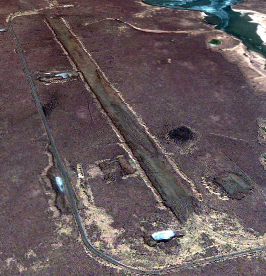
A 2/27/11 aerial view looking northwest showed the Fort Randall Satellite Field remained recognizable but quite deteriorated,
with many of the dispersal pads no longer evident.
____________________________________________________
Original Bethel Airport, Bethel AK
60.78, -161.78 (Southwest of Anchorage, AK)
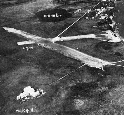
A 1939 aerial view looking east at the original Bethel Airport (from the Nerby family, courtesy of Jojo Prince).
The original location for the airport for the town of Bethel was located adjacent to the west side of the town,
along the northwest bank of the Kuskowim River.
The date of construction of the original Bethel Airport has not been determined.
The earliest depiction of the original Bethel Airport which has been located was a 1939 aerial view.
It depicted the field as having 2 unpaved runways on the northwest shore of the river.
By 1941 the original Bethel Airport was being replaced by a newly-constructed field on the opposite (southeast) bank of the river.
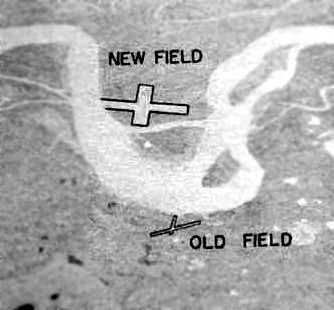
An undated aerial view looking southeast at the original Bethel Airport location (labeled “Old Field”) from a 1943 USAAF Air Route Manual (courtesy of Chris Kennedy).
It depicted the “Old Field” on the northwest bank of the river, with 2 small runways,
as well as the much larger “New Field” on the opposite bank of the river.
The manual said that the “Old field across the river is being abandoned.”

A circa 1940s aerial view looking east at the original Bethel Airport (from the Nerby family, courtesy of Jojo Prince).
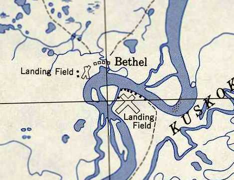
The 1950 USGS topo map (courtesy of Chris Kennedy) depicted the original Bethel Airport location on the west side of the river (labeled “Landing Field”)
as having 2 runways with 2 small buildings on the west side.
The 1972 Bethel Sectional Chart no longer depicted the original Bethel Airport.
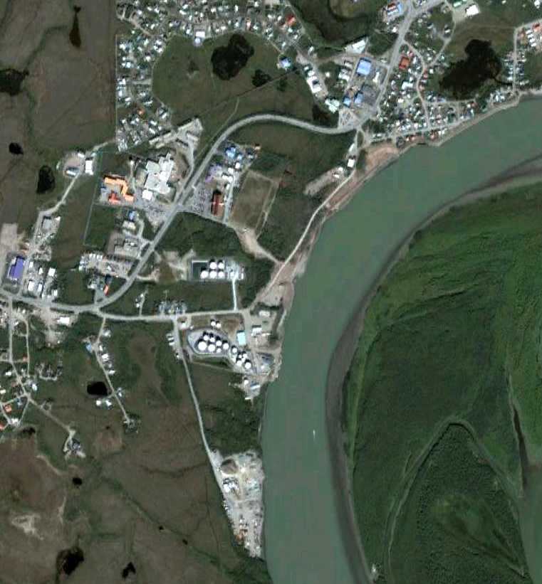
A 8/13/05 aerial view no longer depicted any trace of the original Bethel Airport.
Ironically, the present-day Bethel Airport (the 3rd location of the field) is located only one mile to the west.
____________________________________________________
Bethel Airport (2nd location), Bethel AK
60.775, -161.727 (Southwest of Anchorage, AK)
An undated aerial view looking southeast at the 2nd location of the Bethel Airport (labeled “New Field”)
from a 1943 USAAF Air Route Manual (courtesy of Chris Kennedy).
The second location for the airport for the town of Bethel was located on the southeast bank of the Kuskowim River.
Construction of a runway at this site reportedly began in 1941,
replacing the much-shorter runways of the original airport adjacent to the town.
The earliest depiction of the 2nd location of Bethel Airport which has been located
was an undated aerial view from the 2/20/43 USAAF Air Route Manual (courtesy of Chris Kennedy).
It depicted the “New Field” on the southeast bank of the river, with 2 perpendicular runways,
much larger than the runways of the “Old Field” on the opposite bank of the river.
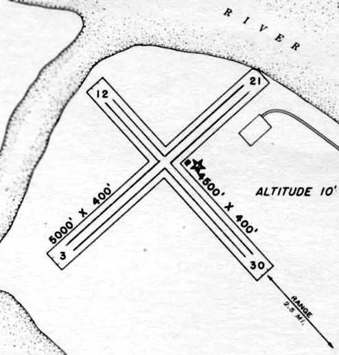
The 2/20/43 USAAF Air Route Manual (courtesy of Chris Kennedy) depicted “Bethel Airfield”
as having 2 asphalt runways: 5,000' Runway 3/21 & 4,500' Runway 12/30.
The field was said to not have any hangars,
but a single small building was depicted just east of the runway intersection.
The field was said to be served by PAA, Star Airways, Peterson Air Service, Woodley Airways, and Peck & Rice Airways.
Bethel was described as being operated by the Civil Aeronautics Administration.
The 1950 USGS topo map (courtesy of Chris Kennedy) depicted the 2nd location of Bethel Airport on the southeast side of the river (labeled “Landing Field”)
as having 2 runways with several small buildings along the west & north sides.
In 1951, control of the Bethel Airport site, plus another 300 acres along Napaskiak Slough, reverted to the USAF.
From 1951-53 the 30th Eng Bn (topo) used 32 acres as a campsite while mapping the area.
In 1954 the 660th Eng Bn used 3 acres for the same purpose.
Neither made any permanent improvements, and the site was abandoned by the DoD in 1954.
The FAA maintained the Bethel Airport site starting in 1955.

A mid 1957 aerial view by LeRoy German of Bethel Airport, which LeRoy recalled was taken “with a Kodak Brownie Haweye box camera.
The houses were for civilian CAA employees & their families. I am not sure what they were doing there.
I was a one-stripe E-2 radio maintenance man in the Air Force while I was there.
The 5-man Detachment 2, 10th Radio Relay Squadron site there is obscured by the photo smudge.
The relay site was being re-located to Tern Mountain, 100 miles west on the coast to improve radio propagation between Cape Romanzoff & Cape Newenham radar sites.
I spent the last 7 months of my tour at the 2-man Tern Mountain site.
The new airport & the 713th AC&W radar site were under construction northwest of Bethel at this time.
We would cross the river to Bethel on the ice in winter, and by boat in summer.”
By 1957, another Bethel Airport was operating in a 3rd location, one mile to the west.
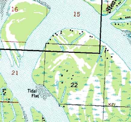
The 1957 USGS topo map depicted the clearings for the 2 runways at the site of the 2nd location of the Bethel Airport,
but it was unlabeled.
The FAA maintained the property of the 2nd Bethel Airport site until 1959, after which the it was utilized by residents for their fish camps.
The August 1986 Bethel Sectional Chart (courtesy of Stu Sibitzky) depicted the 2nd location of Bethel Airport as an abandoned airfield.
In 1998, a contract was awarded to remove drums of tar that had been eroding into the Kuskokwim River from the Bethel Airport site.
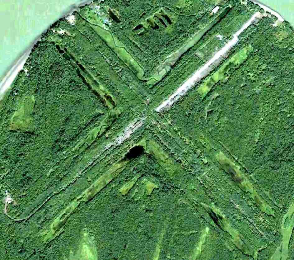
A 8/13/05 aerial showed the very recognizable outline of the perpendicular runways at the site of the 2nd location of Bethel Airport,
with pavement appearing to remain somewhat intact along the former Runway 3/21.
LeRoy German recalled, “I returned there in July 2010 & all that remained was part of the asphalt runway for emergencies.”
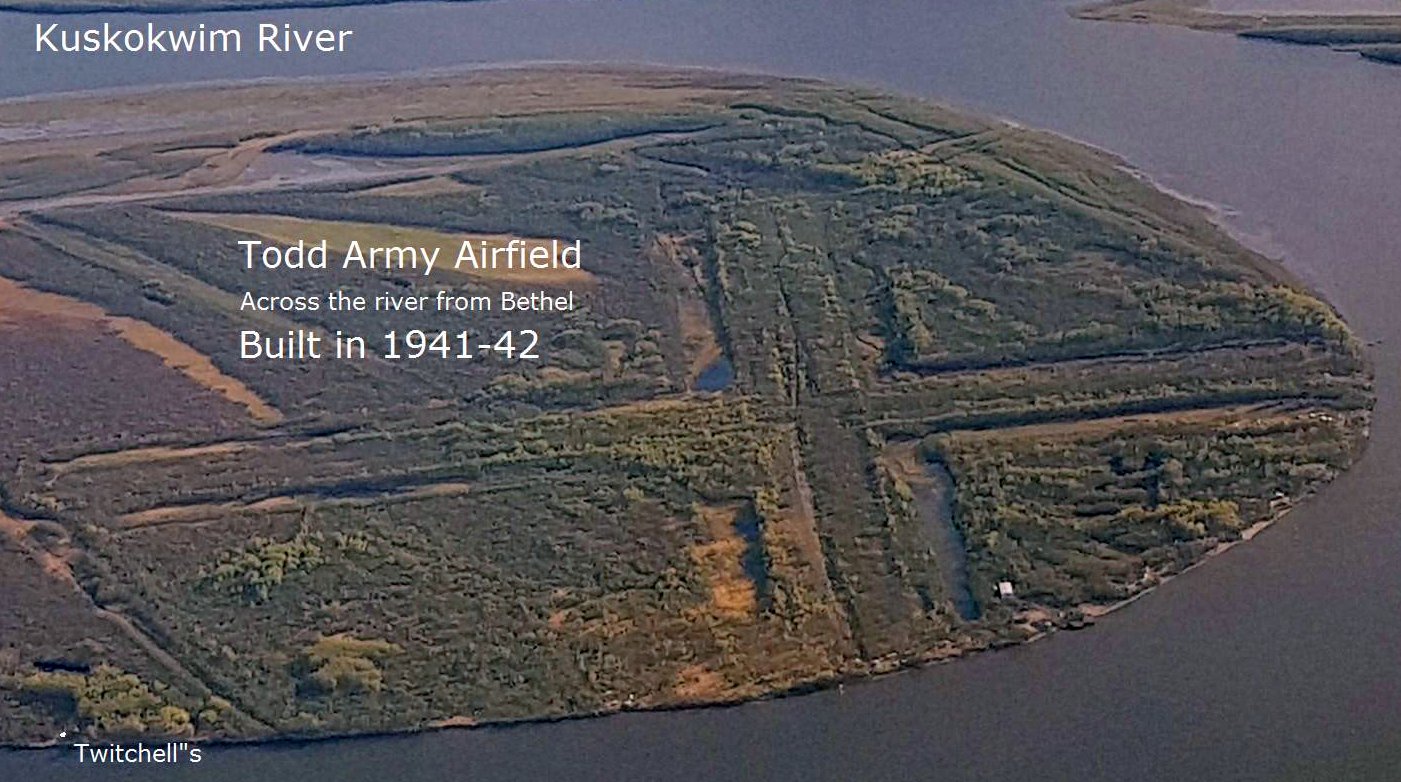
A circa 2018 aerial view by Yuki Nute (courtesy of Mike Nerby) looking west at the remains of the runways at the site of the 2nd location of Bethel Airport.
Although this photo had a label of “Todd Army Airfield”, that was presumably only refered to the 3rd location of Bethel Airport, not this airfield location.
____________________________________________________
Fort Glenn Army Airfield / Otter Point Naval Air Facility, Umnak Island, AK
53.375, -167.895 (Southwest of Anchorage, AK)
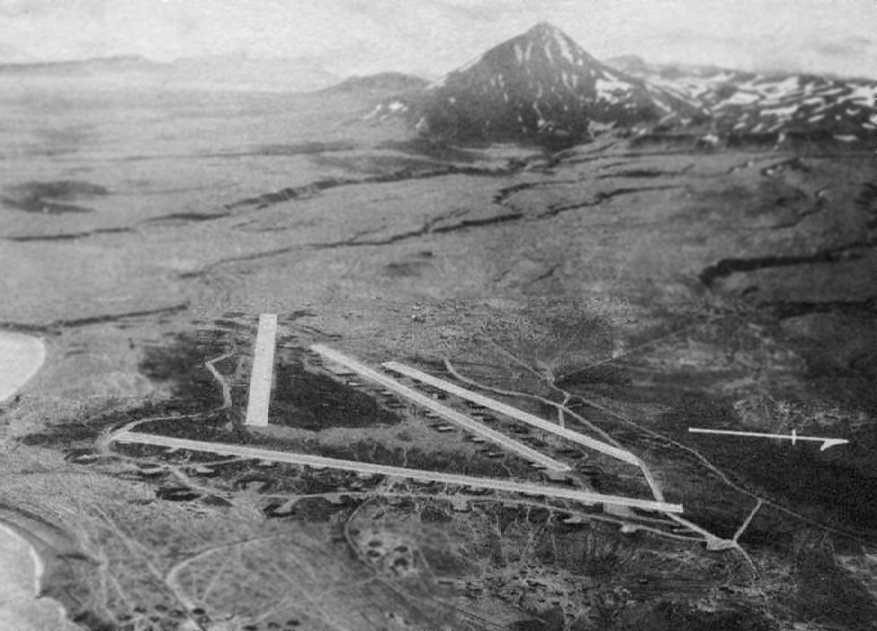
An undated aerial view looking west at Ft. Glenn AAF (from a 2/20/43 USAAF Air Route Manual, courtesy of Chris Kennedy).
The Ft. Glenn site was acquired in 1942, according to an Army Corps of Engineers FUDS report (courtesy of Chris Kennedy).
It was located on Umnak Island at Umnak Pass, the narrow body of water separating Umnak & Unalaska islands.
The 102,062-acre site was improved with Quonset huts, buildings, ammunition magazines, hangars, and 4 paved runways.
Blythe Block recalled, “My father, Stan Block, was with the Army Corp of Engineers & helped build the original airfield.
My father was on the detail which brought the Marsden Mats to the first runway.
If you look at the geography of the island, you might wonder how they got the Marsden Mats up the bluffs to the plateau of the island, so that the first runway could be built.
My father & others rigged a 'mule', some kind of diesel engine, and used it to haul each of the heavy steel mats up the bluff, in order to build the first runway.
Because of the presence of that runway, our fighters were able to repel the first Japanese attacks at Dutch Harbor.
My father & mother hosted some of the PBY pilots stationed near Yakutat Bay, pilots who later died defending our country.”
Bryan Huey reported, “I have an accident report from 1/26/42, involving my grandfather (Air Corps Captain Stanley Huey) crashing his L-1B observation plane after having taken off from Fort Glenn.
He was a member of the 11th Fighter Squadron, but I have also heard it called the 10th Pursuit.
Normally he was a P-40 pilot, but for some reason was out in an observation plane when a snow storm got the best of him.
His passenger [was] 1st Lieutenant Fox.
I found another report of him dumping his P-40E on 12/10/42 at the field, but evidently just damaged his propeller & collapsed the landing gear.”
Charles Donovan recalled, “In May 1942 through December 1944 I was stationed at Chernofski Bay & USNAAS Otter Point, Umnak.
Six of us US Navy radiomen were sent there to set up weather reporting stations.
I was at Otter Point when they were installing the Marsden matting to make it.
I saw the first P-40s, P-38s and B-24s use it.”
George Jones reported, “I was watching the Discovery Military Channel [2005].
They were showing a documentary that covered WWII in Alaska - the Aleutian Island Campaign in particular.
The program pointed out that during the initial build up of Alaskan defenses,
a secret airfield (reportedly disguised as a cannery) was built on the Eastern end of Umnak Island.
Fighters launched from that base (which was later to be called Fort Glenn) were successful in turning back the first Japanese attack on Dutch Harbor -
the Japanese had sent in their bombers without fighter escort.
The whole idea of a secret airbase that, apparently, even the Army brass didn't know about, fascinated me.
It sounded like something right out of a Blackhawk Squadron comic book.”
The Navy's facility, Otter Point Naval Air Facility, was adjacent to the Army Airfield.
According to a Navy report (courtesy of Chris Kennedy),
“Construction was carried out entirely by Seabees & the Army.
The development of the facility at Otter Point was approved by the Secretary of the Navy on 9/18/42,
and Commanding General Alaska Defense Command assigned the required land on 9/25/42.
The work was done by a detachment of the 8th Construction Battalion.”
The Navy report continued, “Housing & messing facilities for 119 officers & 359 men were constructed,
as well as recreational & ship's service buildings.
Storage facilities consisted of 6,975 square feet for general stores & a 150-cubic-foot freezer.
Buildings for aircraft included a kodiak-type hangar, 160' x 90', a squadron warehouse, and a terminal for air transport service.
Administration offices were housed in 5 buildings with a total floor space of 3,850 square feet.
Radio facilities included a transmitting station, a direction-finder station, and a radar station,
all with separate power houses & with housing & messing provisions for personnel.
The hospital, located in one small building, contained 8 beds.”
The Navy report continued, “The maintenance force of the station was installed in 7 buildings.
Electric power was provided by 3 diesel-electric generators.
All other utilities were furnished by the Army at Fort Glenn, which also provided landing strips & revetments,
aviation gasoline & fuels of other types, provisions, and repair facilities for aircraft.”
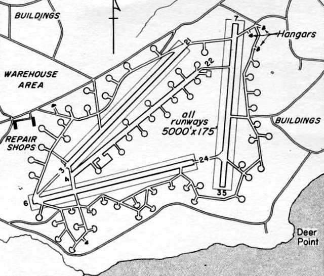
A 2/20/43 USAAF Air Route Manual (courtesy of Chris Kennedy) depicted Ft. Glenn AAF as having an unusual airfield layout,
with 4 paved 5,000' runways, two of which were situated only 10 degrees apart.
Runway 4/22 was described as consisting of steel mat, while the other 3 were said to be under construction.
A network of taxiways ringed the runways, along which were sited no less than 60 individual aircraft dispersal pads.
Three hangars were depicted on the northeast corner of the field, and repair shops were depicted on the west side.
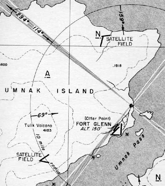
An approach plate for Ft. Glenn AAF from the 2/20/43 USAAF Air Route Manual (courtesy of Chris Kennedy)
depicted Ft. Glenn's 2 satellite fields, #1 located 9 miles north-northwest & #2 located 7 miles southwest.
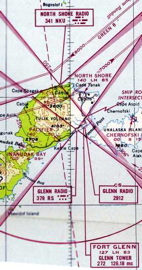
The earliest aeronautical chart depiction which has been located of Ft Glenn AAF
was on the January 1947 World Aeronautical Chart (courtesy of David Brooks).
It depicted Ft. Glenn AAF as having a 8,300' paved runway, and a control tower.
Its 2 satellite airfields were also depicted (North Shore & Pacifier).
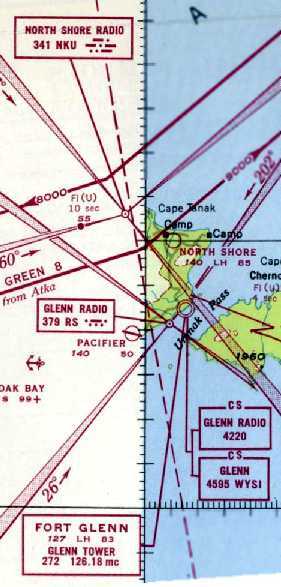
The last aeronautical chart depiction which has been located of Ft Glenn AAF
was on the February 1947 World Aeronautical Chart (courtesy of David Brooks).
It depicted Ft. Glenn AAF as having a 8,300' paved runway, and a control tower.
Its 2 satellite airfields were also depicted (North Shore & Pacifier).

Ft Glenn AAF was labeled generically “Military Airport” on the 1952 USGS topo map.
The Ft. Glenn site was excessed between 1952-55 to the Bureau of Land Management
and later transferred to numerous owners (Native corporations & the State of Alaska),
according to an Army Corps of Engineers FUDS report (courtesy of Chris Kennedy).
No airfield at Ft. Glenn was depicted on the April 1972 Dutch Harbor Sectional Chart.
Ft Glenn AAF was labeled generically “Airport” on the 1988 USGS topo map.
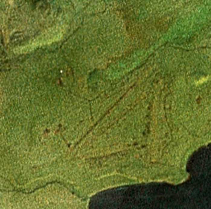
As seen in a circa 2005 aerial photo, the outlines of the former runways of Ft. Glenn were still barely perceptible,
more than 50 years after the field was abandoned.
Marc Hookerman recalled of the Ft. Glenn Airfield, “I was out there in 2005 on a freight contract,
and we graded one of the old runways so it would be usable for larger aircraft.”
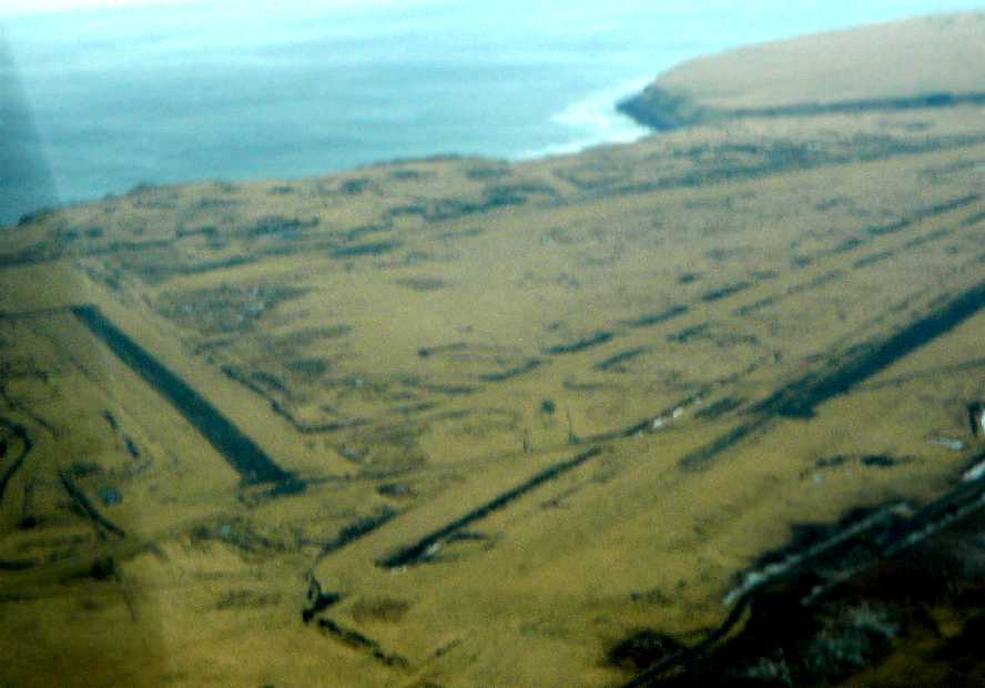
A 2008 aerial view looking south at Ft Glenn Airfield by Dirk Bowen.
Dirk reported, “I went to Fort Glenn today on a medevac. It's not in the Alaska supplement, although it is still in occasional use.
There is a cattle ranch there now, most of the work including herding is done with R-22s, but 2 runways are still usable.”
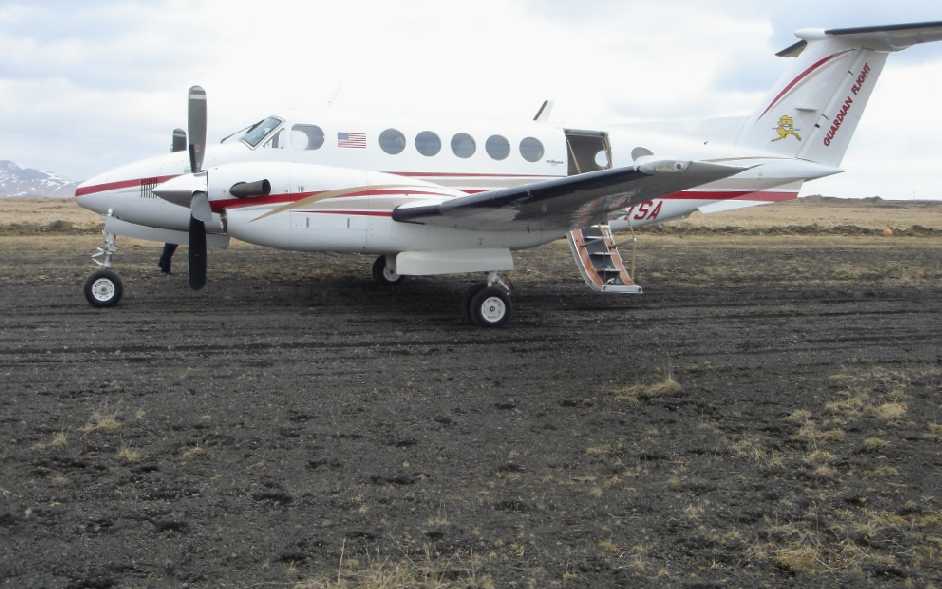
A 2008 photo by Dirk Bowen of the King Air 200 he landed at the Ft Glenn Airfield.
Dirt observed, “It was very soft (I also have a shot of the wheels & the tracks we were leaving, about 3/4 inch deep).
We didn't want to turn around because the runway is narrow & most likely softer on the edges,
so we stopped as short as we could & took off from there.”
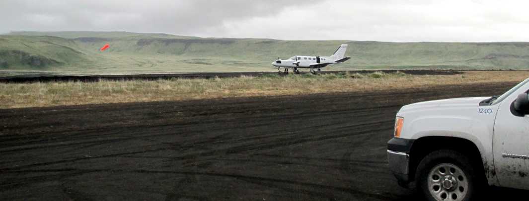
A 6/16/11 photo by Steve of a Cessna 441 at the Ft Glenn Airfield.
Steve reported, “The feds have put out contracts for hazardous waste cleanup at all the WWII sites in Alaska.
I fly for a charter company & we had the contract to support the cleanup crew at Ft. Glenn.
They found chemical bombs. For the last year & a half the various federal agencies have been shuffling paperwork to get permits, etc. to clean it up.”
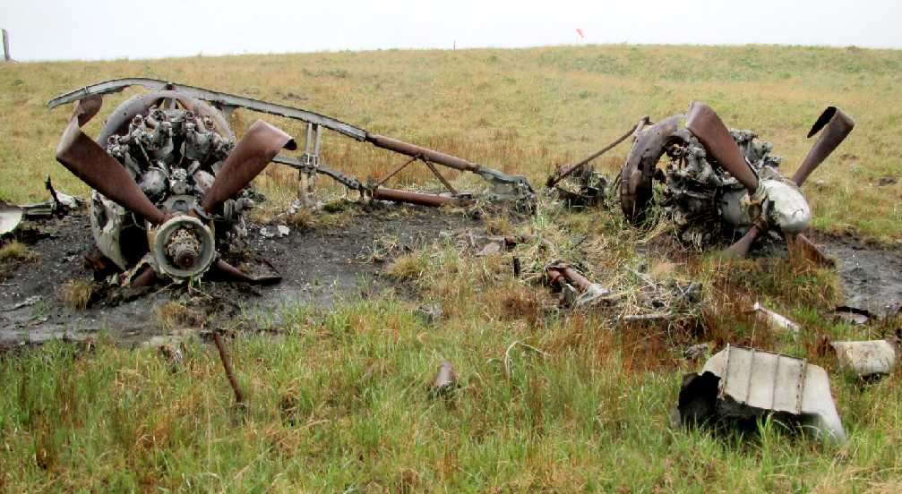
A 6/16/11 photo by Steve of the remains of a Northrop P-61 Black Widow night fighter at the Ft Glenn Airfield (note the windsock in the background).
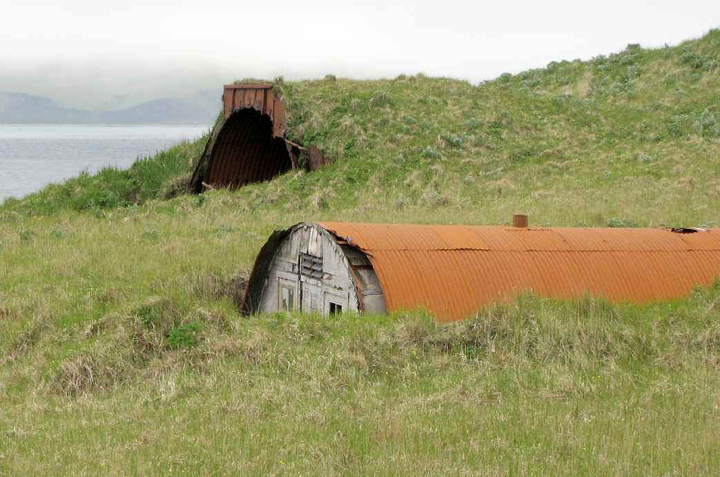
A 6/16/11 photo by Steve (enhanced by Bill Grasha) of 2 Quonset huts at Ft Glenn, one of which is earthen covered.
Steve reported, “Ft. Glenn was huge, covering many square miles. They laid in underground water pipes & ran phone lines all over.
Some of the Quonset huts are 10 miles or more from the runways.”
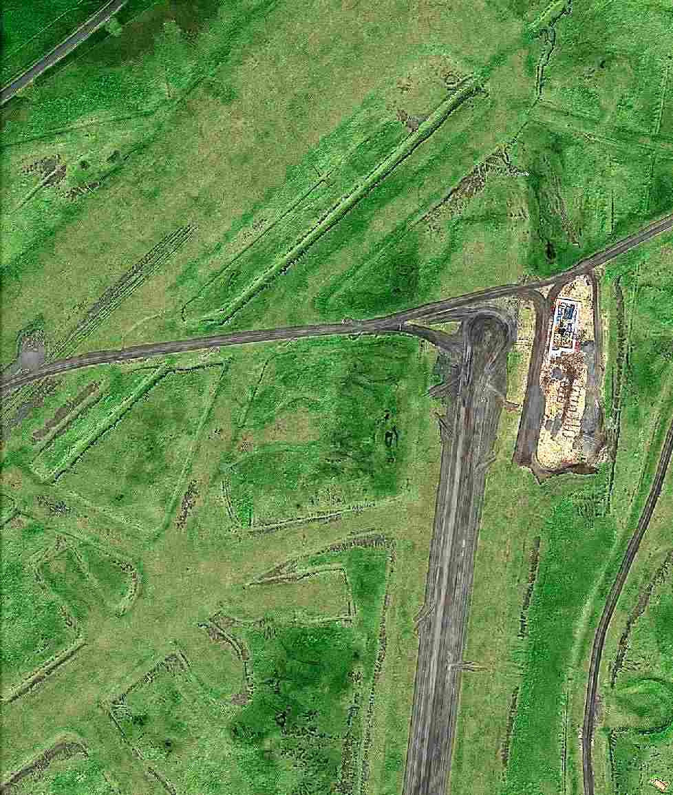
A September 2011 satellite picture of the northeastern portion of a runway & other remains at Ft. Glenn (courtesy of Lars Gleitsmann).
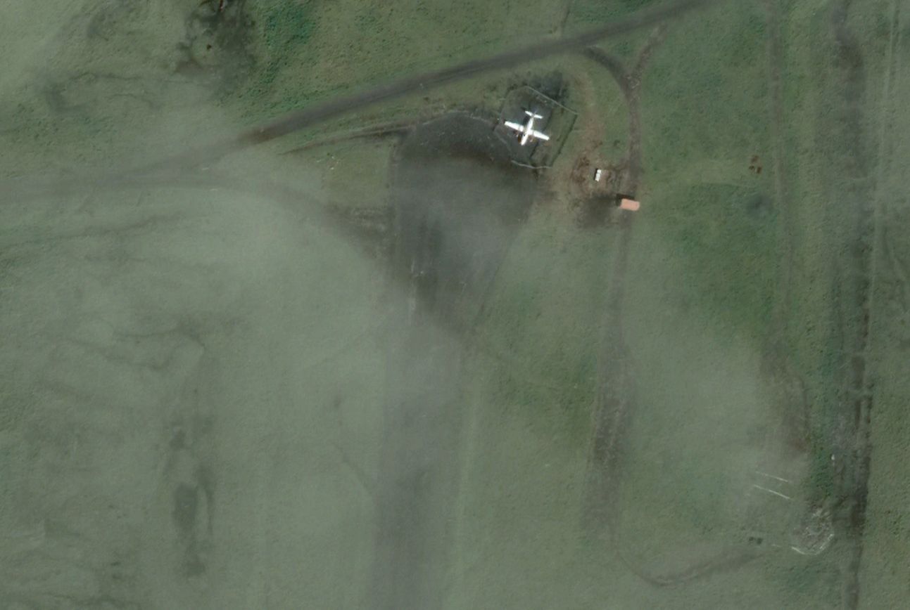
A 2021 aerial photo of a twin-engine plane (a King Air?) within a small fence enclosure just northeast of Ft. Glenn's Runway 17 (courtesy of Daryl Greaser).
Daryl Greaser reported, “There is/was a cattle ranch on Umnak, so I guess maybe they were 'free range' cows at some point, but why is the plane there that long?”
A 2024 aerial view showed the fence enclosure remained just northeast of Ft. Glenn's Runway 17, but the plane was gone.
____________________________________________________
Fort Glenn North Satellite Army Airfield / North Shore Airfield, Umnak Island, AK
53.375, -167.895 (Southwest of Anchorage, AK)
Ft. Glenn Northern Satellite Field, as depicted n an approach plate from the 2/20/43 USAAF Air Route Manual (courtesy of Chris Kennedy).
This was one of two satellite airfields which were built to support the nearby Ft. Glenn Army Airfield, for which 102,062 acres were acquired in 1942, according to an Army Corps of Engineers FUDS report (courtesy of Chris Kennedy).
The earliest depiction which has been located of the Ft. Glenn northern Satellite Field was on an approach plate from the 2/20/43 USAAF Air Route Manual (courtesy of Chris Kennedy).
It the northern “Satellite Field” as having 2 runways.
The earliest aeronautical chart depiction which has been located of the northern Ft Glenn Satellite Field was on the January 1947 World Aeronautical Chart (courtesy of David Brooks).
It depicted “North Shore” Airfield as having an 8,500' runway.
The last aeronautical chart depiction which has been located of the North Shore Airfield was on the February 1947 World Aeronautical Chart (courtesy of David Brooks).
It depicted “North Shore” Airfield as having an 8,500' runway.
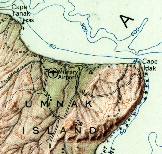
The earliest topo map depiction which has been located of the North Shore Airfield was on the 1952 USGS topo map,
which generically labeled it as “Military Airport”.
The Ft. Glenn site was excessed between 1952-55 to the Bureau of Land Management
and later transferred to numerous owners (Native corporations & the State of Alaska),
according to an Army Corps of Engineers FUDS report (courtesy of Chris Kennedy).
This presumably included its 2 satellite airfields.
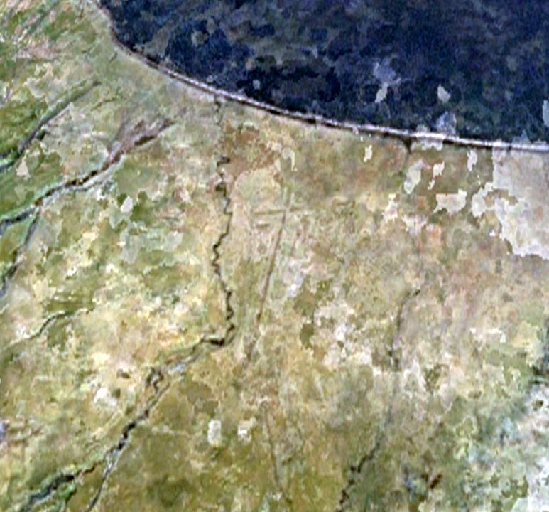
The earliest photo which has been located of the North Shore Airfield was a 1985 aerial view, which showed the remnants of 2 runways still barely recognizable.
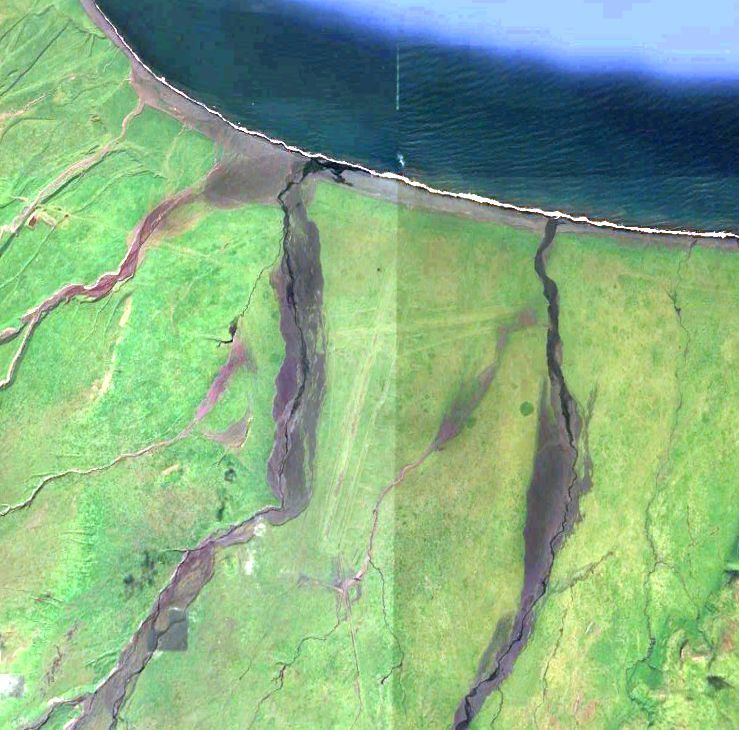
A 2024 aerial view showed the remnants of 2 North Shore's 2 runways to be still barely recognizable.
Thanks to Daryl Greaser for pointing out this airfield.
____________________________________________________
____________________________________________________
Since this site was first put on the web in 1999, its popularity has grown tremendously.
If the total quantity of material on this site is to continue to grow,
it will require ever-increasing funding to pay its expenses.
Therefore, I request financial contributions from site visitors,
to help defray the increasing costs of the site
and ensure that it continues to be available & to grow.
What would you pay for a good aviation magazine, or a good aviation book?
Please consider a donation of an equivalent amount, at the least.
This site is not supported by commercial advertising –
it is purely supported by donations.
If you enjoy the site, and would like to make a financial contribution,
you
may use a credit card via
 :
:

Please consider checking the box to make a monthly donatation.
For a mailing address to send a check, please contact me at: paulandterryfreeman@gmail.com
If you enjoy this web site, please support it with a financial contribution.
____________________________________________________
This site covers airfields in all 50 states.