
Abandoned & Little-Known Airfields:
California: Western San Jose area
© 2002, © 2026 by Paul Freeman. Revised 9/1/26.
This site covers airfields in all 50 states: Click here for the site's main menu.
____________________________________________________
Please consider a financial contribution to support the continued growth & operation of this site.
For a 10th year, the CA pages of this website are sponsored by the California Pilots Association:
Ames Airport (added 8/8/23) - Centerville Airport / Center Field (revised 7/12/24) - Cooley Field (revised 7/19/23)
Hiller Aircraft Factory Airfield (revised 2/20/26) - Hummingbird Haven (revised 9/29/24) - (Original) Palo Alto Airport / Palo Alto School of Aviation Airport / Goddard Airport (revised 9/1/26)
Progressive Airport / Mountain View Airport (revised 9/24/21) - Redwood City Airport / Sanders Airport (revised 7/20/23)
Santa Clara Valley Airport (revised 11/23/18) - NOLF Abel / NOLF Coelho / Warm Springs Airport (2nd location) (revised 12/26/24)
____________________________________________________
37.165, -121.966 (Southwest of San Jose, CA)
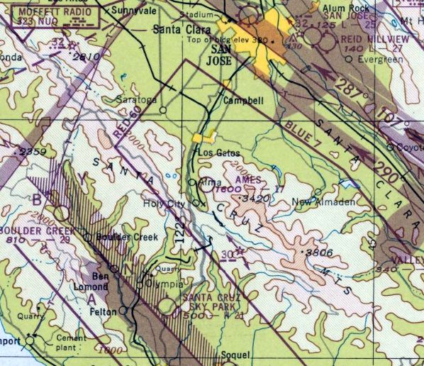
Ames Airport, as depicted on the February 1948 San Francisco Sectional Chart.
This small hilltop airport was evidently established at some point between 1947-48,
as it was not yet depicted on the 1943 USGS topo map nor the August 1947 San Francisco Sectional Chart.
The earliest depiction which has been located of Ames Airport was on the February 1948 San Francisco Sectional Chart.
It depicted Ames as having a mere 1,700' unpaved runway.
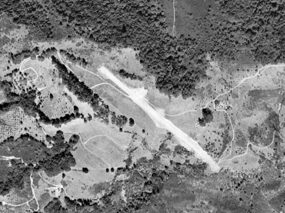
The earliest photo which has been located of Ames Airport was a 9/26/48 USGS aerial view.
It depicted a single northwest/southeast runway, with 1 small T-hangar on the northeast side.
No aircraft were visible on the field.
The earliest airport directory listing which has been located of Ames Airport was in the 1948 Haire Airport Directory (courtesy of Jonathan Westerling).
It described Ames Airport as a private field, managed by Ralph Ames, having a single 1,600' unpaved runway.
Remarks included, “Zero approach both ends, strip carved out of side hill, 'Table top' only 50' wide in spots.”
Ginger Radonich recalled, “I lived just below the 'landing strip' as we called it.
Wreckage of several planes were up there. I believe it was built to bring guests to Lupin Lodge,
but was too dangerous to land there.”
Ken Anderson recalled, “We knew it as Ames Airport. I believe it was owned by the Ames family.
He worked in Sunnyvale & flew to & from work as an executive in the 1940s/50s.”
Scott Peranto recalled, “Small airstrip with crosswinds.
I remember hearing of someone landing there & taking the wings off the plane & trucking it down the mountains.”
Regular use of Ames Airport may already have ceased by 1953, as a 1953 aerial photo showed the T-hangar had been removed at some point between 1948-53.
But the runway remained intact.
The last airport directory listing which has been located of Ames Airport was in the 1954 Airport & Business Flying Directory (courtesy of Jonathan Westerling).
It described Ames Airport as a “Limited” airfield, having a single 1,800' unpaved northwest/southeast runway.
Remarks included, “Hazardous, sloping, soft when wet."
Ames Airport was not depicted on the 1955 USGS topo map.
A 1956 aerial photo showed the Ames Airport runway remained distinct, but without any sign of recent aviation use.
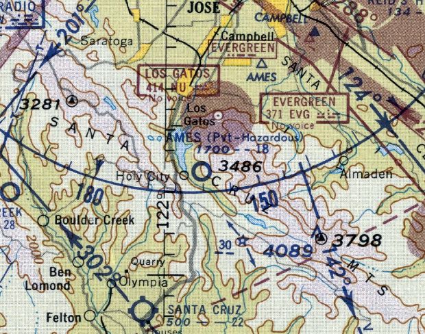
The last aeronautical chart depiction which has been located of Ames Airport was on the September 1957 San Francisco Sectional Chart.
It depicted Ames as a private airfield, “Hazardous”, having a mere 1,800' unpaved runway.
Ames Airport was evidently closed, for reasons unknown, at some point between 1957-58,
as it was no longer depicted on the April 1958 San Francisco Sectional Chart.
A 1968 aerial photo showed a dramatic change in the status of Ames Airport compared to 1956,
with most of the runway surface having been removed or overgrown.
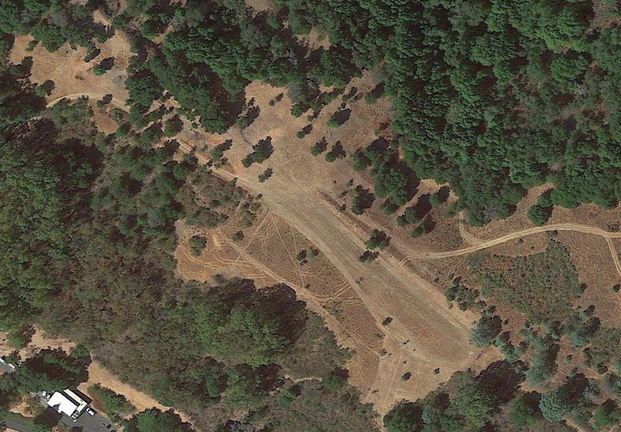
A 2021 aerial view shows the northwest/southeast clearing remains of the former Ames Airport runway.
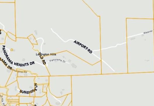
As of 2023 the county assessor's map (courtesy of Doug Rice) depicted Airport Road on the site of Ames Airport.
Thanks to Doug Rice for pointing out this airfield.
____________________________________________________
Hiller Aircraft Factory Airfield, East Palo Alto, CA
37.477, -122.151 (Southeast of San Francisco, CA)
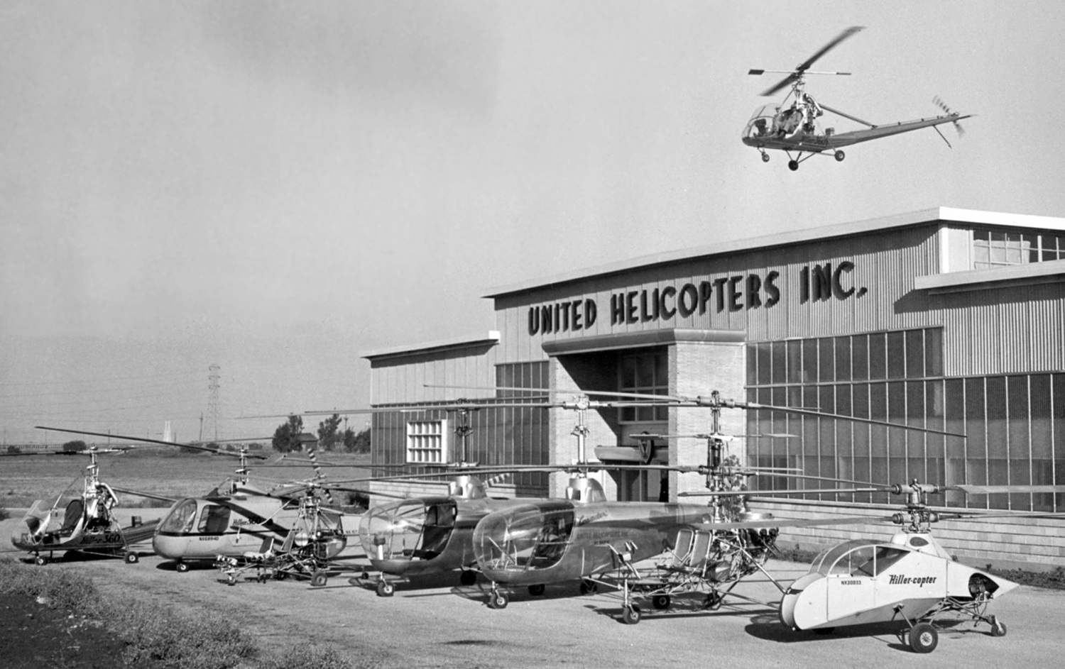
A 1948 photo of the East Palo Alto United Helicopters plant, with a variety of Hiller helicopters, including the UH-4 Commuter, UH-12, and Stanley Hiller's original HillerCopter.
No airfield was depicted at this location on a 1941 aerial view (according to Jonathan Westerling).
Stanley Hiller was an early pioneer in helicopter development.
He opened a factory on East Palo Alto's Willow Road in the late 1940s, initially under the name of United Helicopters, but renamed Hiller Helicopters in 1948.
The earliest depiction which has been located of this facility was a 1948 photo a variety of Hiller helicopters
(including the UH-4 Commuter, UH-12, and Stanley Hiller's original HillerCopter) in front of the “United Helicopters Inc.” plant.
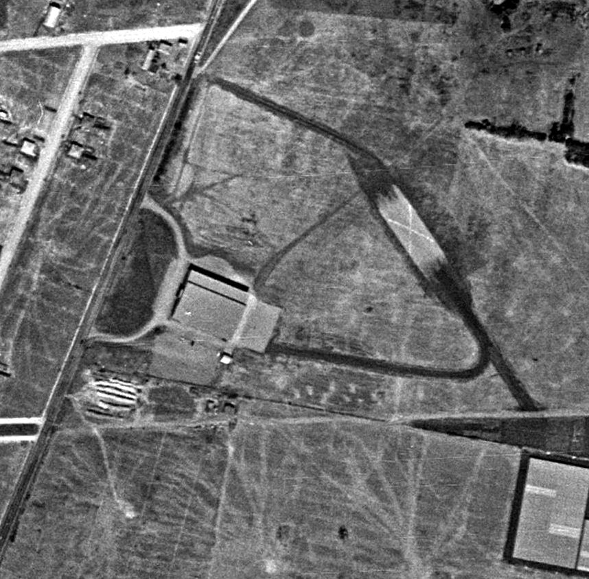
The earliest aerial view which has been located of the Hiller Aircraft Factory Airfield was a 1948 aerial photo.
It depicted the factory on the east side of Willow Road. A taxiway led toward a curious northwest/southeast runway, short but wide, marked with a large “X”.
The Hiller Aircraft Factory Airfield was not yet depicted on the February 1948 San Francisco Local Aeronautical Chart (courtesy of Tim Zukas),
or subsequent aeronautical charts from the 1950s-60s.
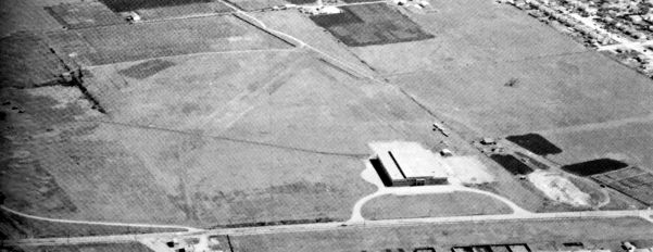
A 1949 aerial view looking east at the Hiller Aircraft Company Factory Airfield (courtesy of Kevin Walsh)
depicted the Hiller Factory on the south side of a grass airfield.
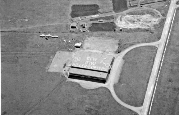
A 1949 aerial view looking south at the Hiller Aircraft Company Factory Airfield (courtesy of Kevin Walsh)
depicted 3 single-engine fixed-wing aircraft parked next to the Hiller Aircraft plant (ironic since Hiller only manufactured helicopters).
The roof of the helicopter plant was painted “Hiller-Copters Palo Alto”.
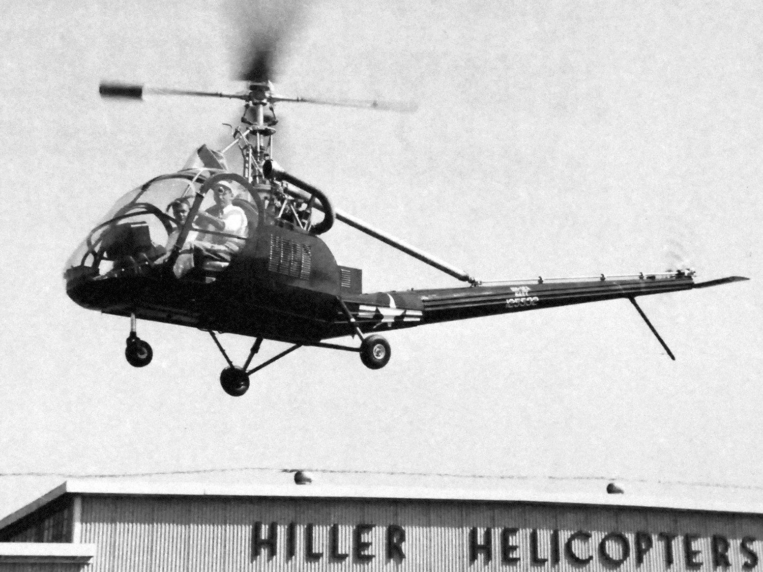
A May-September 1950 photo of the first US Navy Hiller, HTE-1 125532 C/n 163, seen flying in front of the Hiller Helicopters plant.
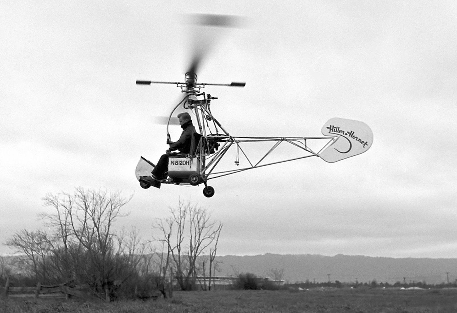
A 1951 photo of ramjet-powered Hiller HJ-1 Hornet prototype N8120H C/n 2001 at the Hiller plant.
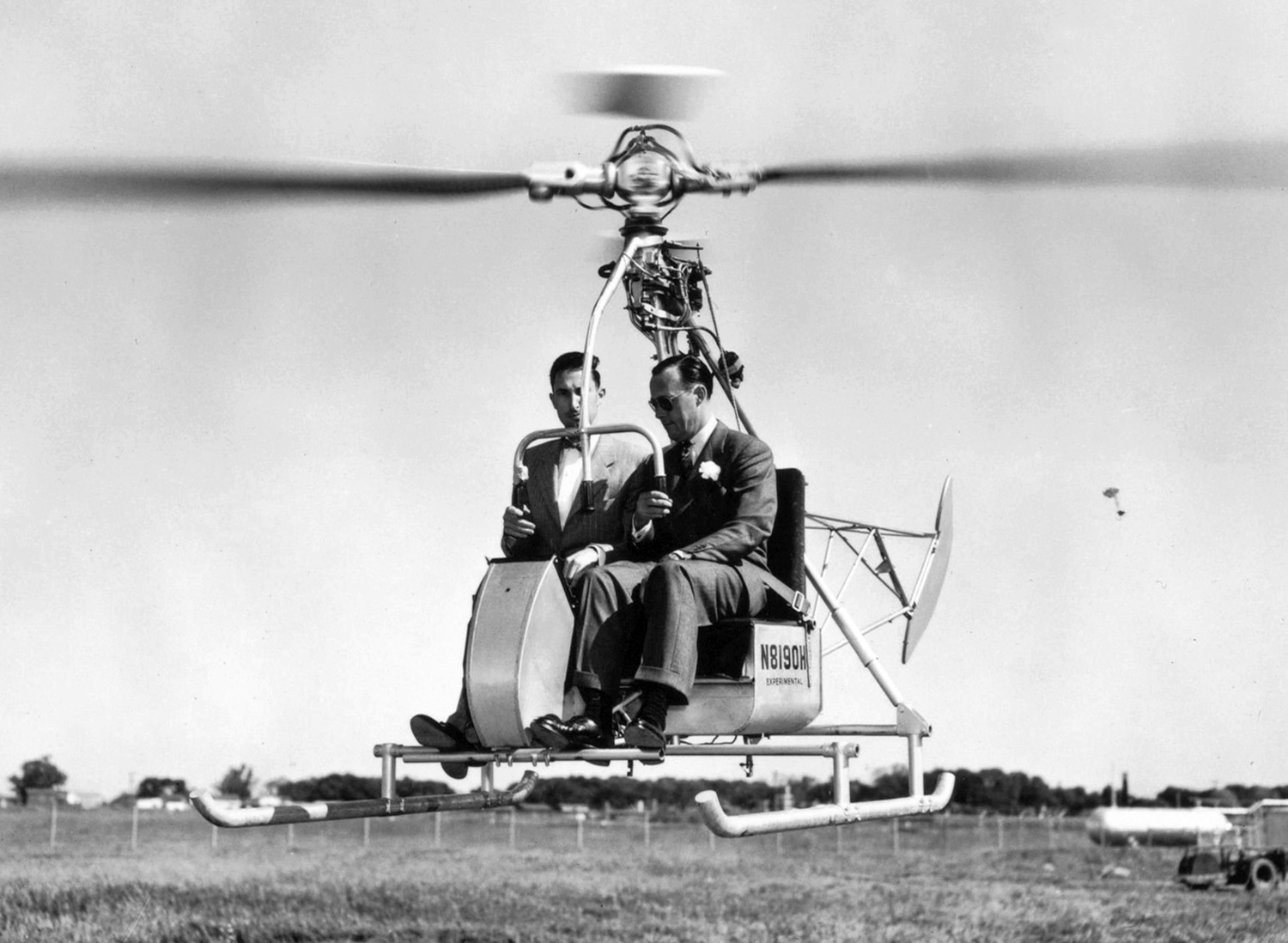
A 4/18/52 photo of Stanley Hiller & Netherlands Prince Bernhard flying HJ-1 Hornet N8190H C/n 2003, an early civil prototype of the Hiller HJ-1 ramjet-powered helicopter, at the Hiller plant.
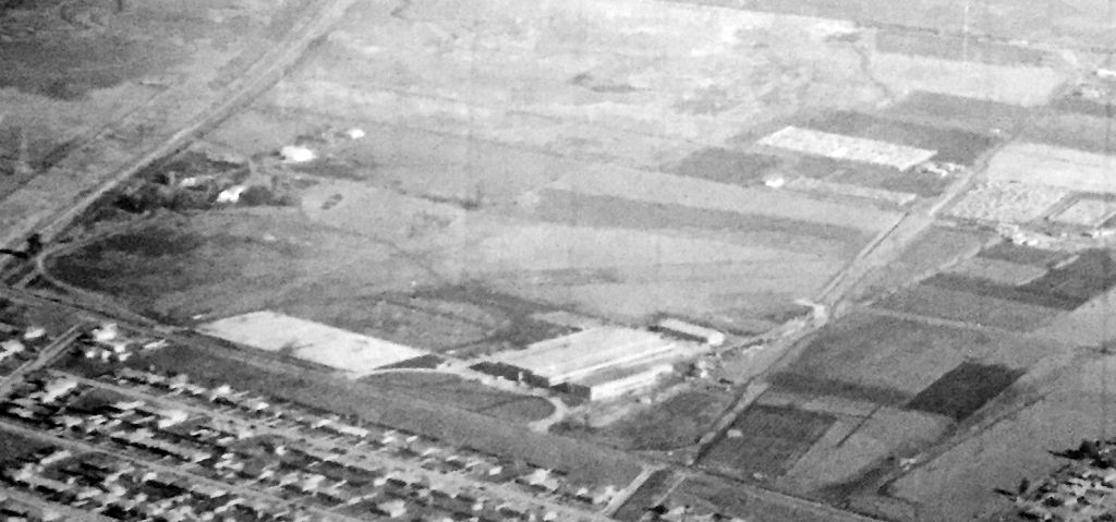
A circa 1952 aerial view looking east at the Hiller Aircraft Company Factory Airfield (courtesy of Kevin Walsh).
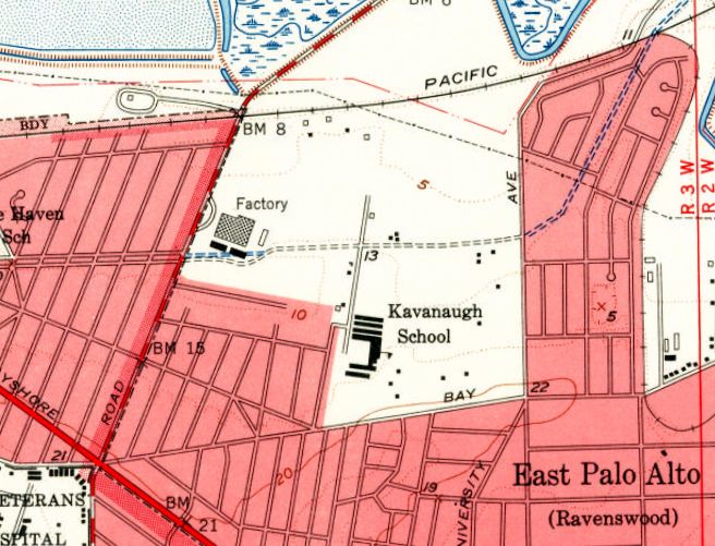
The 1953 USGS topo map depicted the Hiller Aircraft factory, labeled simply as “Factory”, but did not depict any airfield.
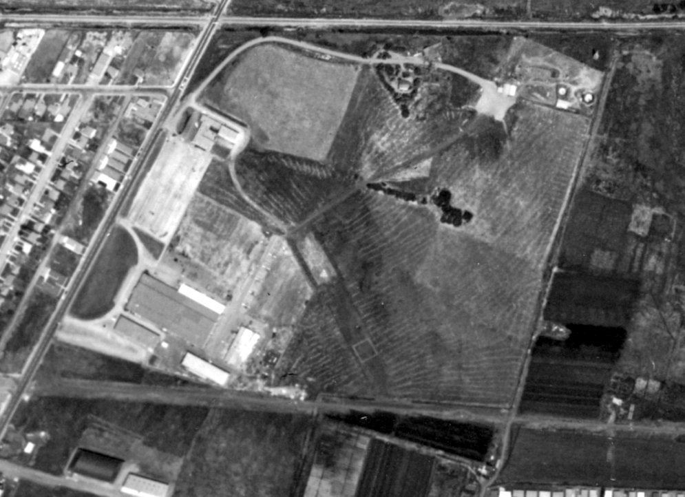
A 1956 aerial view (from the UCSB Library, courtesy of Jonathan Westerling) depicted the Hiller Aircraft Factory Airfield as having a short northwest/southeast runway, marked with several helicopter landing spots,
and a row of 5 helicopters parked east of the factory on the west side.
The Hiller Aircraft Factory Airfield was not depicted on the April 1959 San Francisco Local Aeronautical Chart.

A 1959 aerial view (courtesy of Kevin Walsh) looking east at the Hiller Aircraft Factory showed several helicopters parked north of the factory (left side of photo).
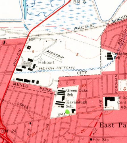
The 1961 USGS topo map showed that several additional buildings had been added around the Hiller Aircraft factory.
It had also gained a “Heliport” to the east of the factory, along with a short northwest/southeast “Airstrip”.
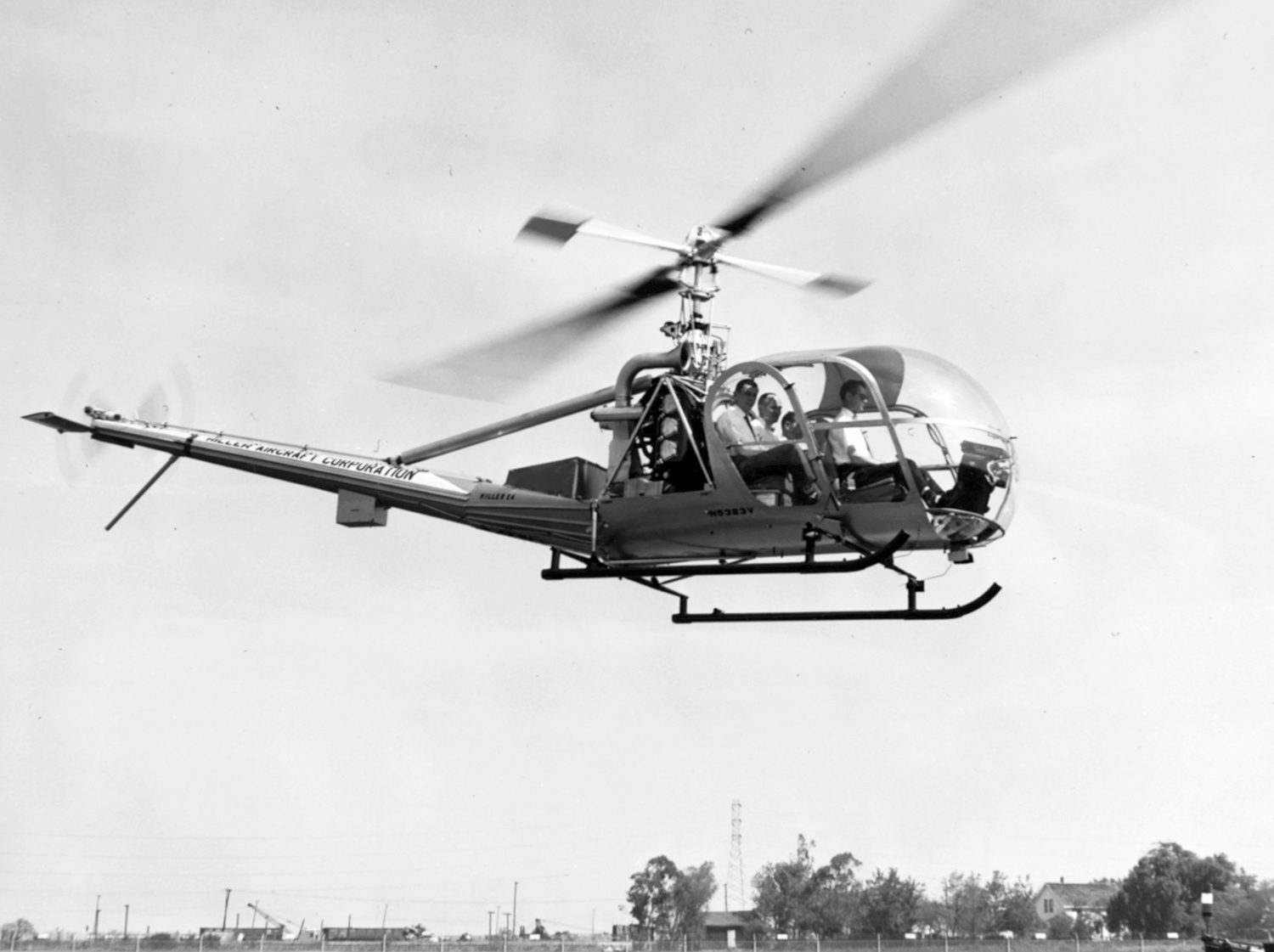
A 1961 photo of Hiller UH-12E4 N532V C/n 942 (which had been converted to the 4-seat “flying station wagon” configuration with a stretched cockpit) flying at the Hiller plant.
According to Wikipedia, “From the early 1960s to 1969, its Palo Alto plant served as a CIA cover for the production of the CORONA reconnaissance satellites.
Hiller was purchased by Fairchild Aircraft in 1964.”
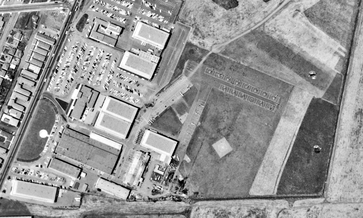
A 1965 aerial view (from the UCSB Library, courtesy of Jonathan Westerling) depicted the Hiller Aircraft Factory Airfield at perhaps its peak of aircraft production,
with over 20 helicopters visible parked northeast of the factory.
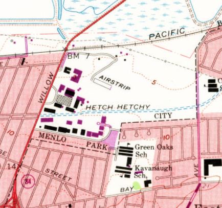
The 1968 USGS topo map showed that even more buildings had been added around the Hiller Aircraft factory.
However the heliport was no longer depicted, and the “Airstrip” had lost half its length compared to the 1961 depiction.
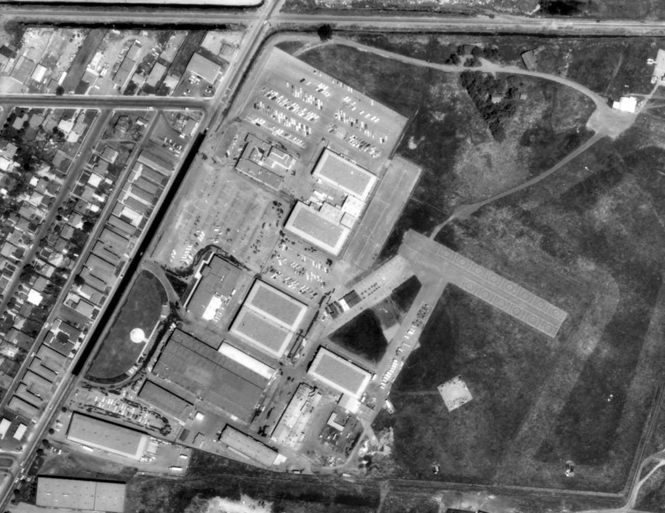
The last photo which is available of the Hiller Aircraft Company Factory Airfield was a 1968 aerial view (from the UCSB Library, courtesy of Jonathan Westerling).
It showed a dramatic difference compared to the 1965 photo only 3 years before, with all of the helicopter parking spots being empty, presumably due to the facility having shifted to production of satellites instead.
The 1973 USGS topo map still depicted the Hiller factory, but no longer depicted the runway.
A 1980 aerial photo showed that streets & buildings had been constructed over the site of the Hiller Aircraft Factory Airfield,
but the factory building remaining standing.
A 1991 aerial photo showed the Hiller Aircraft factory building had been replaced by several other buildings,
erasing the last trace of this site of early helicopter technological development.
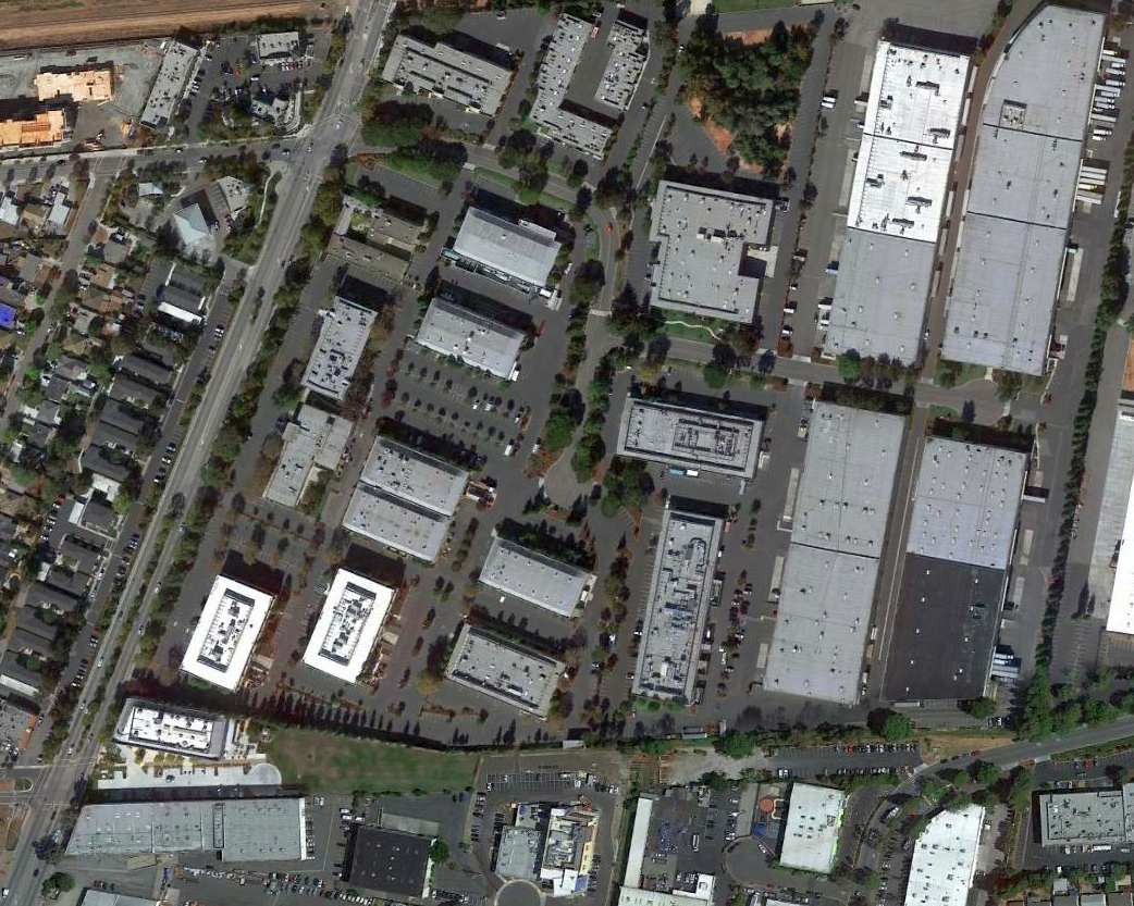
A 2015 aerial view showed no trace remaining of the Hiller Aircraft Factory Airfield.
As of 2018, street maps show many of the buildings covering the site of the Hiller Aircraft Factory Airfield comprise the operations of Facebook.
The site of the Hiller Aircraft Factory Airfield is located northeast of the intersection of Willow Road & O'Brien Drive.
Thanks to Kevin Walsh for pointing out this airfield.
____________________________________________________
Palo Alto Airport (Original) / Palo Alto School of Aviation Airport / Goddard Airport, Palo Alto, CA
37.429, -122.158 (Southeast of San Francisco, CA)
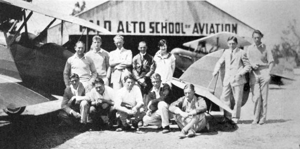
An undated group photo in front of 2 biplanes & the hangar of the Palo Alto School of Aviation from the 1928 Stanford Quad (courtesy of Kevin Walsh).
Jonathan Westerling reported, “The original location for the Palo Alto Airport was right next to the football stadium at Stanford.
The airport started in 1928.”
According to an article entitled “Flying Work Begins For Student Airmen At Aviation School” in the 2/8/28 Stanford Daily (courtesy of Jonathan Westerling),
“'Gas on; are you ready? Contact!' And the first student was off for his flying instruction from Lt. Norman Goddard at the Palo Alto Airport.
Eight men have passed the required State medical examination, and started actual flying yesterday. Technical classes are held in the evening.
There are now 2 new Waco planes for student instruction at the Palo Alto School of Aviation, and 5 more are to be delivered within 90 days.
The Waco is a small plane with double controls, powered by a 90 horsepower Curtiss OX-5 motor.
'The field is still pretty soft,' said Goddard, 'but we are rolling it into condition with a tractor & it will have an excellent surface when it dries out.'
The hangar, with a classroom & 2 workshops in the back, is finished, but construction on the administration building will not be completed until the end of the week.
A Ford airplane, one of the small machines designed from an economical standpoint to meet the general public's demand for a low-priced product, will be on display at the field next week.”
According to an article entitled “Aviation School Uses Dole Flight Airplane Source” in the 3/5/28 Stanford Daily (courtesy of Jonathan Westerling),
“The El Encanto, renamed the Gypsy, in which Lt. Norman Goddard entered the Dole flight to Honolulu last summer,
has been reconditioned & has passed the Department of Commerce test.
It will be used immediately for instruction at the Palo Alto School of Aviation.
The El Encanto cracked up with Goddard's navigator at the controls when it started from the Oakland airport last summer.”
The earliest depiction which has been located of the original Palo Alto Airport
was an undated group photo in front of 2 biplanes & the hangar of the Palo Alto School of Aviation from the 1928 Stanford Quad (courtesy of Kevin Walsh).
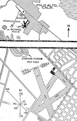
The location & layout of the Palo Alto School of Aviation Airport from the 10/8/28 Commerce Department Airway Bulletin (courtesy of Jonathan Westerling).
It depicted the “Palo Alto School of Aviation” Airport as being located adjacent to the southeast side of the Stanford University stadium polo field.
The airfield was described as a 200 acre rectangular property,
having 4 grassy runways (the longest being the 4,000' northwest/southeast strip), with a 80' x 60' iron hangar on the northeast side.
The owner & operator was listed as Lt. Norman Goddard.
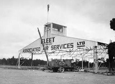
An undated photo of the beginning of construction for the hangar of Fleet Associated Air Services at the original Palo Alto Airport (courtesy of Jonathan Westerling).
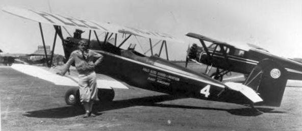
An undated photo of pilot Paul Mantz next to a Fleet biplane with the markings of the “Palo Alto School of Aviation, Stanford University” (courtesy of Jonathan Westerling).
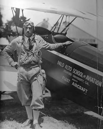
An undated photo of pilot Paul Mantz next to a Fleet biplane with the markings of the “Palo Alto School of Aviation, Stanford University” (courtesy of Jonathan Westerling).
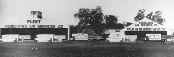
An undated photo of the hangars of Fleet Associated Air Services at the original Palo Alto Airport (courtesy of Jonathan Westerling).
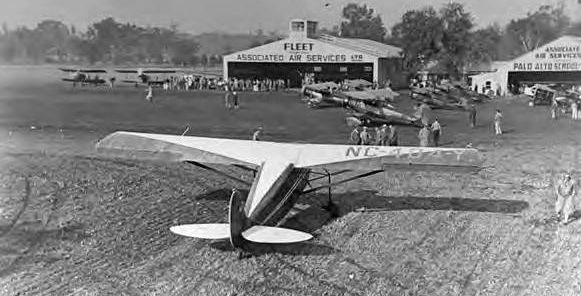
An undated photo of several planes & spectators (possibly viewing an airshow?) in front of the hangars of Fleet Associated Air Services at the original Palo Alto Airport (courtesy of Jonathan Westerling).
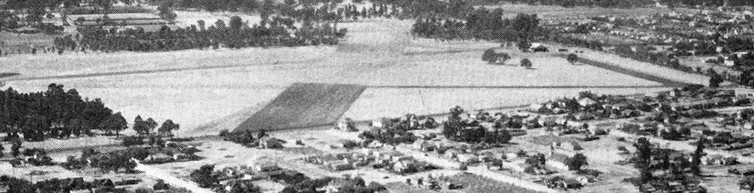
A 1930 aerial view looking northwest at the original Palo Alto Airport (courtesy of Kevin Walsh).
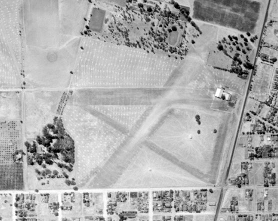
A 1930 aerial view showed the original Palo Alto Airport to have 3 unpaved runways & a few small hangars on the northeast side (from the UCSB Archive, courtesy of Kevin Walsh).
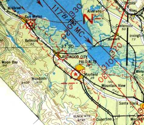
The earliest aeronautical chart depiction which has been located of the original Palo Alto Airport was on a 1932 Air Navigation Map.
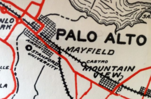
A 1932 map (courtesy of Kevin Walsh) depicted the “Airport” adjacent to Stanford University.
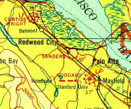
Palo Alto Airport was evidently renamed Goddard Airport at some point between 1932-33,
as that it how it was labeled on the 1933 Airway Map.
According to an article entitled “Airport Removal Decision Expected” in the 11/22/34 Stanford Daily (courtesy of Jonathan Westerling),
“The Palo Alto City Council is expected to come to a decision concerning the removal of the Palo Alto Airport & School of Aviation,
now located on the campus, to a new location, by the end of the week.
Plans have been made, should present negotiations be completed, to move the entire airport & aviation school
to a tract of land located just across the Bayshore Highway at the end of Embarcadero Road.
The removal of the airport has been under consideration for some time.
Several years ago airport officials commenced negotiations with the Palo Alto council to secure the proposed tract of land, but these efforts proved useless.
Recently there has been much opposition to the airport by Mayfield residents, who claim that the noise of the planes is an unnecessary disturbance.
The proposed airport will be much larger, and the airport officials hope that the Mayfield opposition will aid them in securing the land from the city of Palo Alto.”
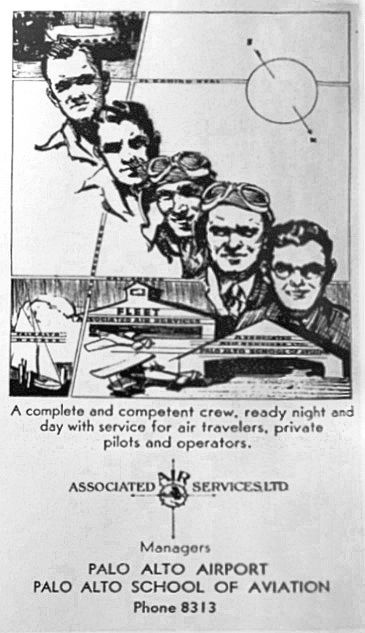
The last depiction which has been located of the original Palo Alto Airport was a 1935 advertisement (courtesy of Kevin Walsh, enhanced by Bill Grasha)
for “Associated Air Services Ltd., Managers, Palo Alto Airport.”
According to an article entitled “Palo Alto Airport Day celebrates 80 years in the Baylands” in the 9/25/15 Palo Alto Weekly (courtesy of Jonathan Westerling),
“The controversy pitted 2 of Palo Alto's top lawyers against each other until a settlement was finally ironed out between the City of Palo Alto & the residents.
The airport was moved to the baylands in January 1935.
An original wooden hangar from the Stanford site was disassembled & moved to the baylands.”
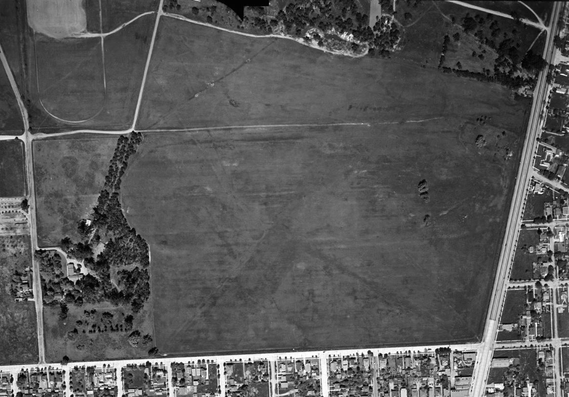
A 4/17/41 aerial view of the original Palo Alto Airport site to have faintly recognizable traces of the 3 runways, but the former hangars were gone (from the UCSB Archive, courtesy of Kevin Walsh).
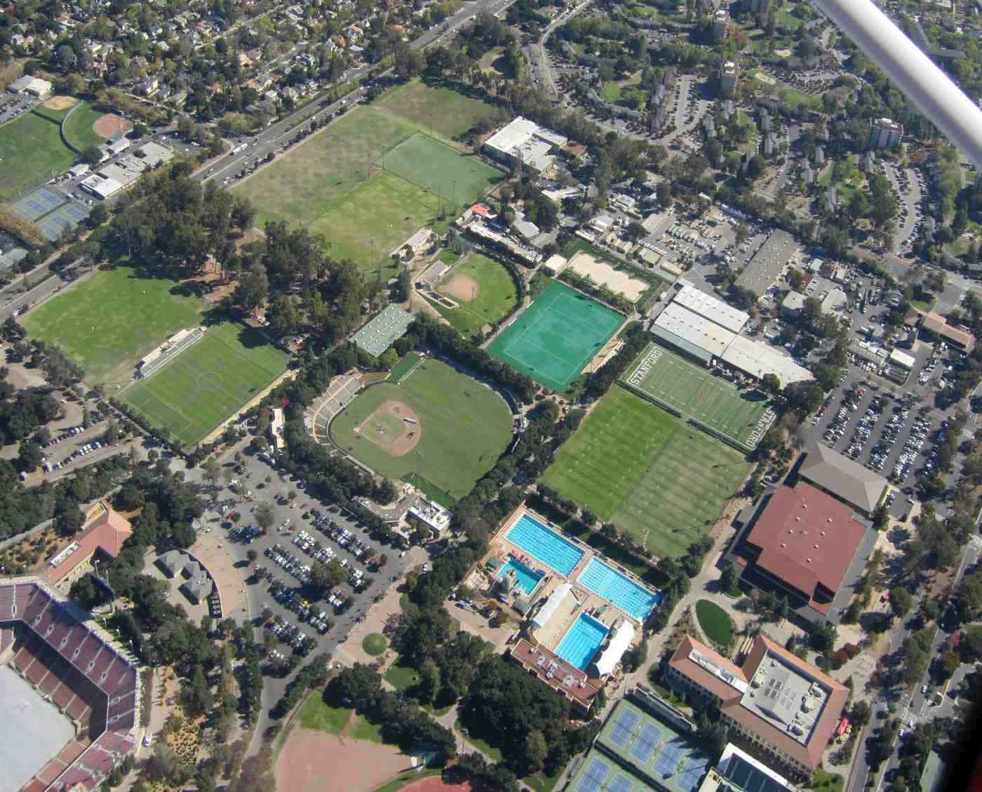
A 10/30/15 aerial view by Jonathan Westerling showed no trace remaining of the original Palo Alto Airport.
Thanks to Jonathan Westerling for pointing out this airport.
____________________________________________________
Redwood City Airport / Sanders Airport, Redwood City, CA
37.49, -122.22 (Southeast of San Francisco, CA)
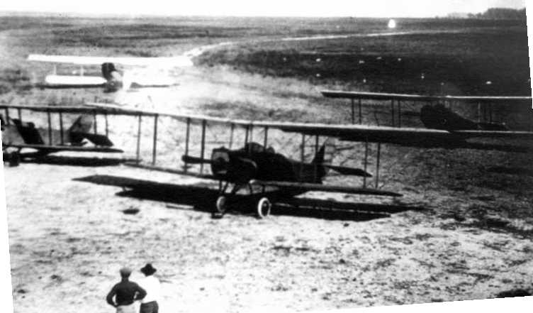
A circa 1917 photo of 4 biplanes (which all appear to be Curtiss JN4 Jennies) at Redwood City Airport.
According to “MSS Wings Over San Francisco Bay” by R.T. Reuther (courtesy of Jim Douglass),
“Redwood City Airport [was] established in 1916 by Silas Christofferson and later owned by Frank Bryant.”
According to www.aerofiles.com, Harry Christofferson established the aircraft manufacturer Christofferson Motor Company in May 1916 at Redwood City,
but “Manufacturing ended shortly after Silas Christofferson was killed in a crash on 10/31/16.”
The earliest photo which has been located of Redwood City Airport
was a circa 1917 photo of 4 biplanes (which all appeared to be Curtiss JN4 Jennies).
According to the Redwood City Public Library, “Frank Bryant purchased the business [Christofferson Aviation School] in 1917 and renamed it the Redwood City School of Aviation.”
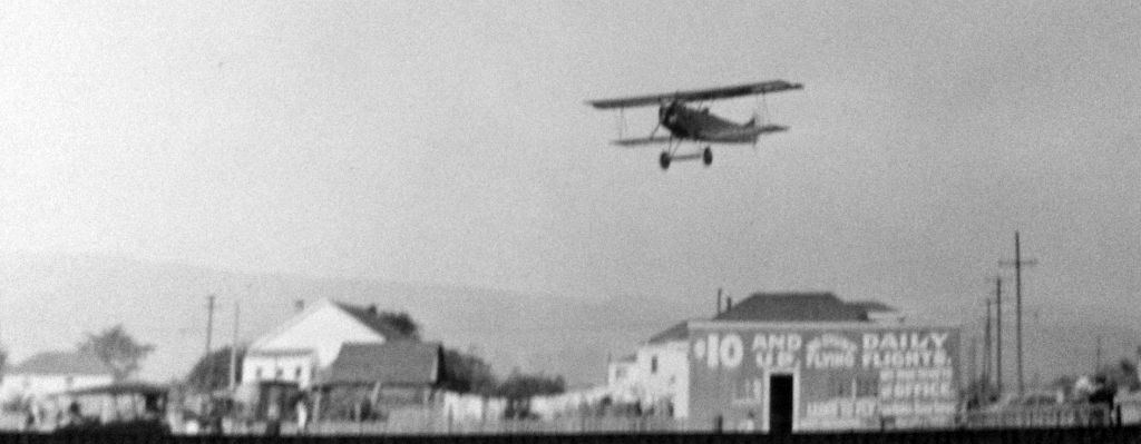
A December 1910 of Frank Bryant's J-1 Standard biplane over Redwood City Airport (courtesy of the Hiller Aviation Museum, via Jonathan Westerling).
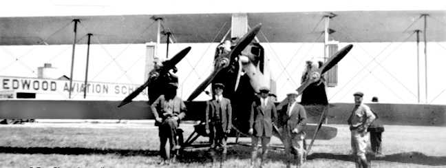
A circa 1920 photo of a Curtiss Eagle trimotor biplane in front of a building marked “Redwood Aviation School” (courtesy of Jonathan Westerling).
According to “MSS Wings Over San Francisco Bay” by R.T. Reuther (courtesy of Jim Douglass),
“Walter Varney... In 1920 with financial assistance from his father he bought the lease to the Redwood City Airport.
By 1920 he was doing business in conjunction with the Checker Cab Company, with charter flights & freight haulage.
In 1921 Varney moved his flying school to San Mateo.”
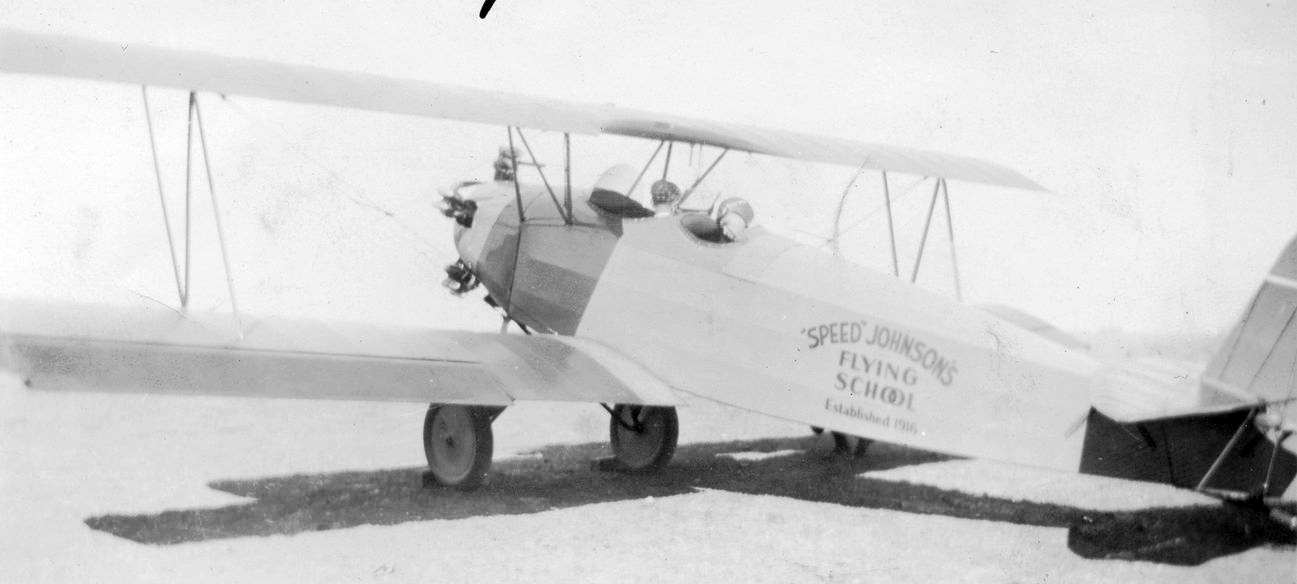
A circa 1920s photo of a Speed Johnson's Flying School biplane (model unidentified) at Redwood City Airport (courtesy of Kevin Walsh).
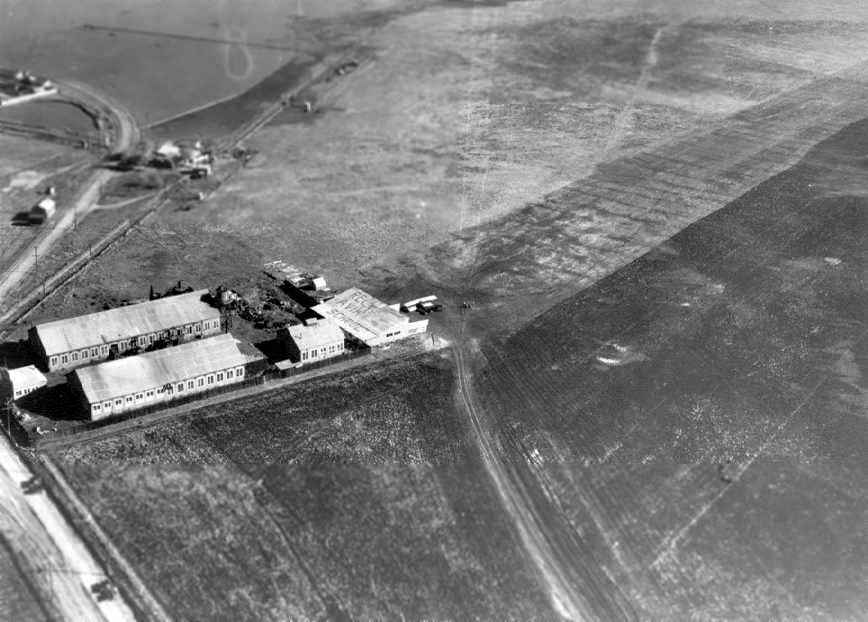
A 1925 photo showing a biplane in front of a building with “Redwood Aviation School” painted on the roof (courtesy of Jonathan Westerling),
showing Redwood City Airport to consist of a large grass field with 4 buildings, and Chestnut Street on the lower left.
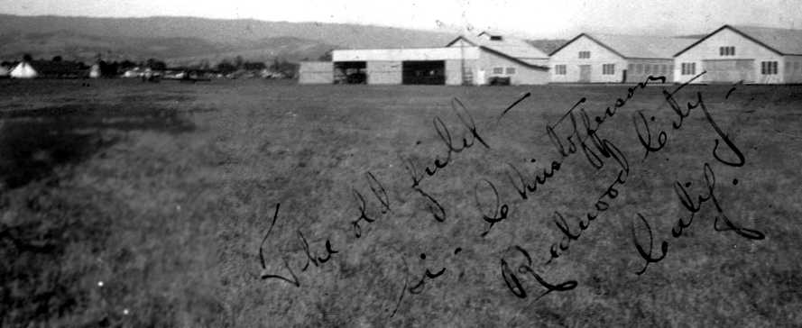
A 1930 photo of the hangars at Redwood City Airport (courtesy of Jonathan Westerling).
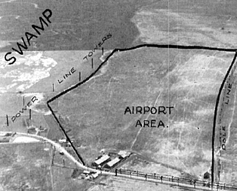
An undated aerial photo looking southeast at Redwood City Airport from the 1930 Richfield Airport Directory (courtesy of Jonathan Westerling).
The earliest aeronautical chart depiction which has been located of Redwood City Airport was on a 1932 Air Navigation Map.
Redwood City Airport was evidently renamed Sanders Airport at some point between 1932-33,
as that it how it was labeled on the 1933 Airway Map.
According to the Redwood City Public Library, “The airport existed until the early 1930s, when the land was subdivided & sold for commercial use.”
However, that date may have been erroneously early, as it continued to be listed in airport directories until the late 1930s.
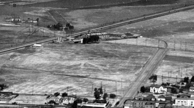
A 1936 aerial view of Redwood City Airport (courtesy of Kevin Walsh).
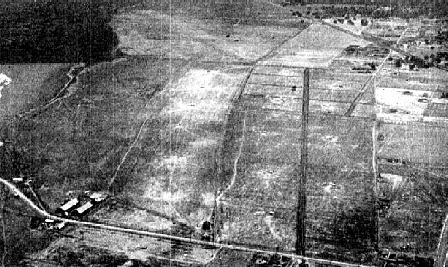
The last photo which has been located showing Redwood City Airport / Sanders Airport still intact
was an undated aerial view looking east from The Airport Directory Company's 1938 Airport Directory (courtesy of Jonathan Westerling).
The Airport Directory Company's 1939 Airport Directory (courtesy of Jonathan Westerling)
described Redwood City as a commercial airport, having one sod 4,000' runway, with the name on its hangar.
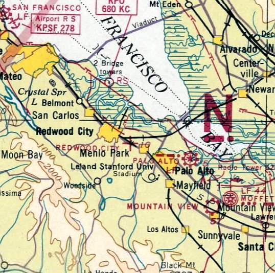
The last aeronautical chart depiction which has been located of Redwood City Airport was on the February 1939 San Francisco Sectional Chart.
It depicted Redwood City Airport as an auxiliary airfield.
Redwood City Airport / Sanders Airport was evidenty closed by 1941, as it was no longer depicted on the April 1941 San Francisco Sectional Chart
or the 1943 USGS topo map.
According to Mark Williams, “The hangar & ramp area became property of the State Highway Department.”
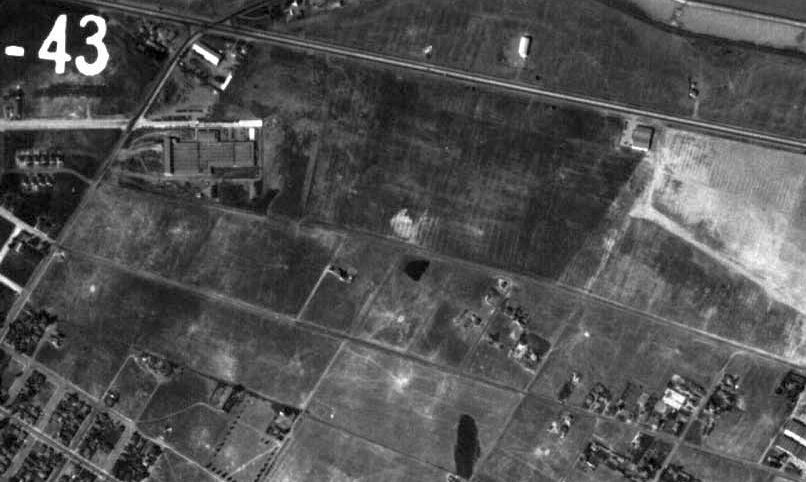
A 10/5/43 aerial photo (courtesy of Jonathan Westerling) showed that a large building had been constructed on the western side of the Redwood City Airport site.
However, a former hangar remained standing on the northwest corner of the property, along with possibly another hangar on the east side.
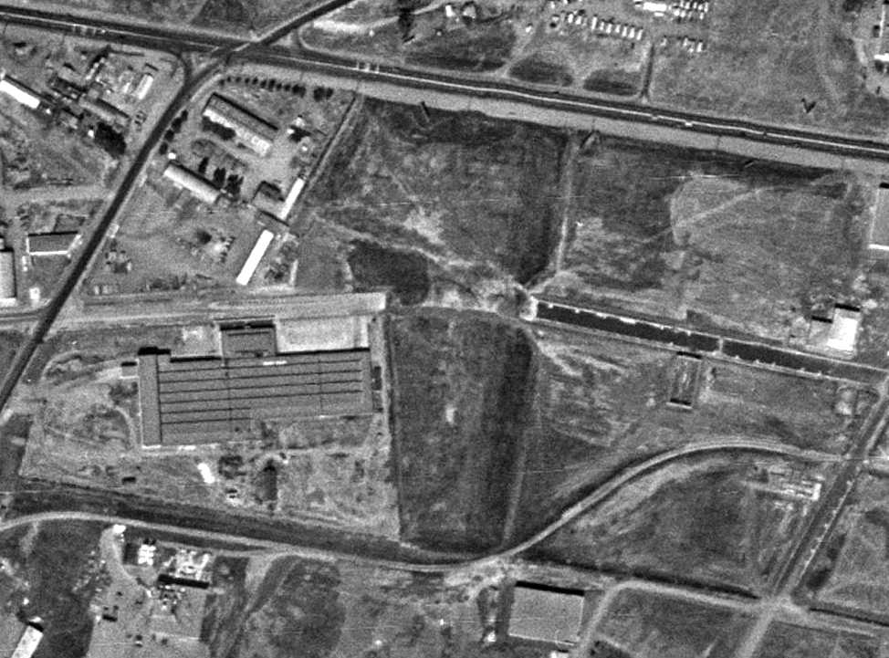
A 9/26/48 aerial view showed that further buildings had been constructed at some point between 1943-48 on the eastern parts of the Redwood City Airport property.
But amazingly the letters “Redwood City” were still recognizable on a former hangar which remained standing on the northwest corner of the property.
A 1991 USGS aerial photo showed that the hangar had been removed at some point between 1948-91,
erasing the last trace of Redwood City Airport.
However, Dave Knochenhauer reported in 2005, “There is a building, now a restaurant, in the vicinity that the oldtimers say was the airfield office.”
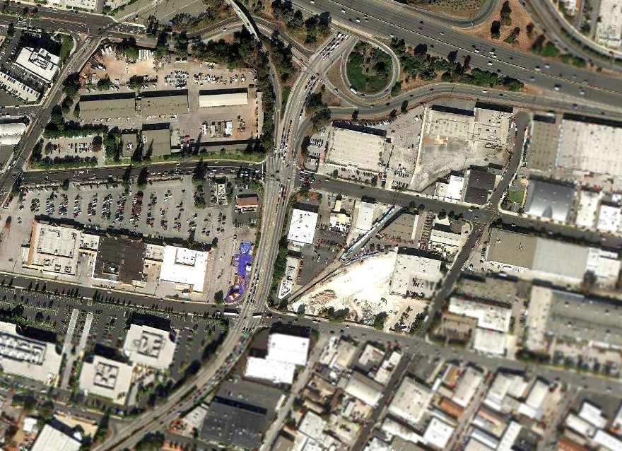
An 11/1/11 aerial view showed no remaining recognizable trace of Redwood City Airport.
The location of the hangars is reportedly today the Redwood City Corporation Yard.
The site of Redwood City Airport is located southeast of the intersection of Interstate 101 & Seaport Boulevard.
____________________________________________________
Progressive Airport / Mountain View Airport, Mountain View, CA
37.41, -122.1 (Southeast of San Francisco, CA)
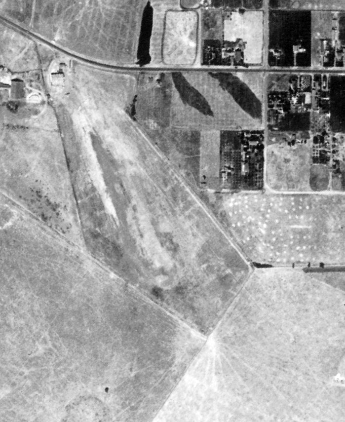
Mountain View Airport, as depicted on a 7/31/39 aerial view (from the UCSB Library, courtesy of Eric Flint).
According to a booklet published for the City of Mountain View's centennial (courtesy of John Kostka),
"Progressive Air Service, Mountain View Airport” was established in 1936 by John Simonic.
It had approved Civil Aviation Administration instructors for private commercial & flight training courses; general aircraft maintenance & repair.
According to the 8/14/36 Mountain View Register-Leader (courtesy of John Kostka), the first graduate of the school was a Manuel Munes.
This flight school was also used by the Aviation Department of San Jose State University.
The airfield would fly an airmail service up to San Francisco's Mills Field for the first time on 5/23/38 with 1002 pieces of mail.
This flight had been advertised all week.
The pilot was a Ted Simon, accompanied by an airport representative named Louis Long.
The earliest photo which has been located of Mountain View Airport was a 7/31/39 aerial view (from the UCSB Library, courtesy of Eric Flint).
It depicted Mountain View Airport as having an unpaved northwest/southeast runway, with a hangar & 1 light single-engine aircraft on the northwest side.
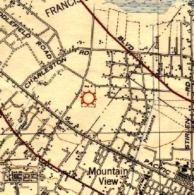
The earliest map depiction which has been located of an airport in Mountain View was an unlabeled depiction on the 1940 USGS topo map (courtesy of Mark Lakata).

The earliest aeronautical chart depiction which has been located of Mountain View Airport
was on the April 1941 San Francisco Sectional Chart (courtesy of Paul Columbus).
It depicted Mountain View as a commercial/municipal airport.
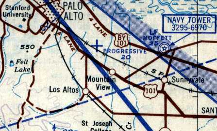
Progressive was depicted as an auxiliary airfield on the 1943 AAF Oakland Aeronautical Approach Chart (courtesy of Jonathan Westerling).
Jonathan surmised that “Progressive was likely a company name.”
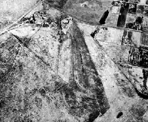
A 8/5/43 aerial view looking north from the 1945 AAF Airfield Directory (courtesy of Scott Murdock) depicted Mountain View Airport as having an unpaved north/south runway.
The 1945 AAF Airfield Directory (courtesy of Scott Murdock) described the Mountain View Airport
as a 50 acre irregularly-shaped field having 2 gravel & sod runways, measuring 2,800' NNW/SSE & 2,000' east/west.
The field was said to have 3 wood & metal hangars, the largest being two 80' x 55' structures.
Mountain View Airport was said to be owned & operated by private interests.
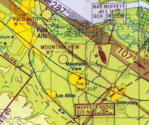
The last aeronautical chart depiction which has been located of Mountain View Airport was on the 1948 San Francisco Local Aeronautical Chart (courtesy of Tim Zukas).
It depicted Mountain View Airport as having a 2,800' unpaved runway.
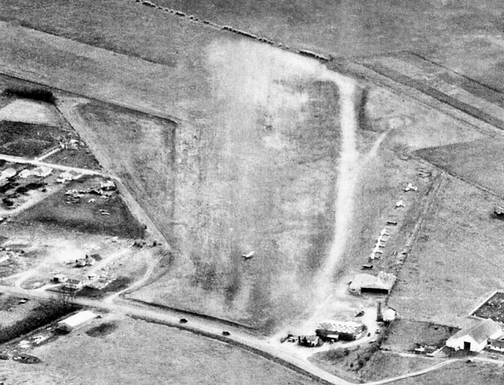
A 1948 aerial view looking south at Progressive Airport (courtesy of Mark Lakata)
depicted the field as having 2 unpaved runways, with 2 hangars (one with a checkerboard-painted roof) & 9 light aircraft parked outside.
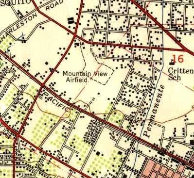
The 1948 USGS topo map (courtesy of Mark Lakata) depicted “Mountain View Airfield” as an irregularly-shaped outline.
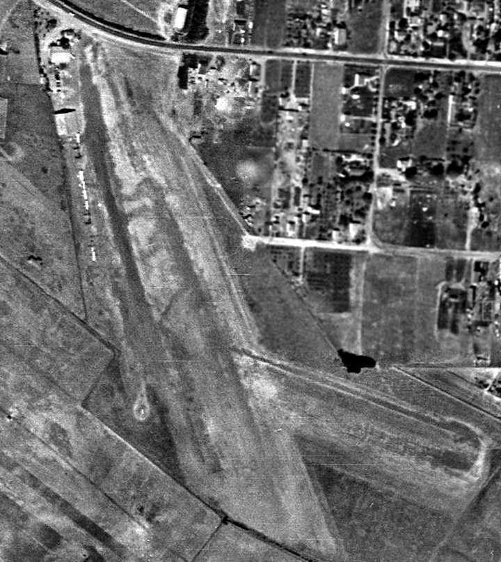
A 1948 aerial view (courtesy of Mark Lakata) depicted Mountain View Airport
as having 2 unpaved runways, with a hangar & a dozen light aircraft on the northwest side.
Judy Rowlee reported, “I found my father's log book from 1948/49.
He [Ed Wasson] flew out of Mountain View... He started in July of 1948,
and did lessons out of Mountain View until he stopped in June of 1949. He had a total of 87 hours.”
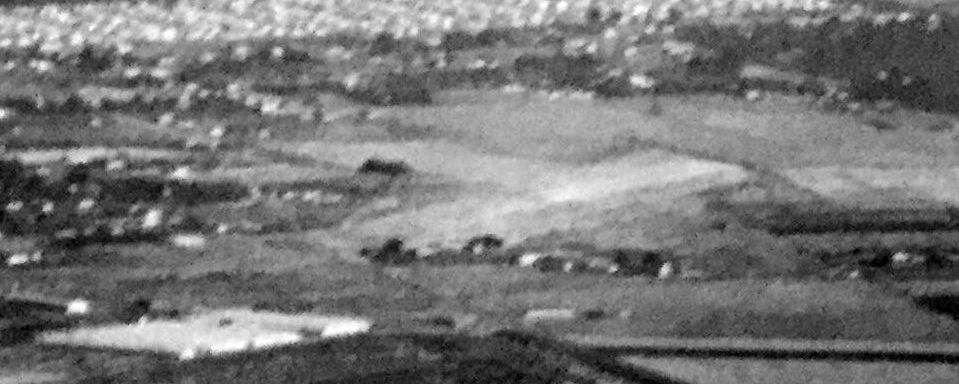
The last photo which has been located of the Mountain View Airport was a circa 1949 aerial view looking southeast (courtesy of Kevin Walsh).
According to John Kostka, “The founder of the airfield continued to fight for Progressive for many years,
helping to veto a proposed skeet range that was to be built next door on San Antonio Road,
citing that there was a 'danger of shotgun pellets falling on runway & hitting low-flying aircraft'.
Though I do not know the exact year the airfield was closed,
I can say that Progressive Air Services was listed in the 1950 Palo Alto Phone book, but no later as far as I know;
and the housing tract was built in 1953, making the year of closing either 1951 or 1952.
An aerial photograph in the Mountain View Library showing the new housing tract,
has off in the corner a small hangar with a checkered roof, presumably a remnant of the airport.”
Harry Gordon recalled, “My Eichler home was one of the first built in 1954 on the site of the Progessive Airport.”
A 1956 aerial photo showed housing covering the site, with not a trace remaining of Mountain View Airport.
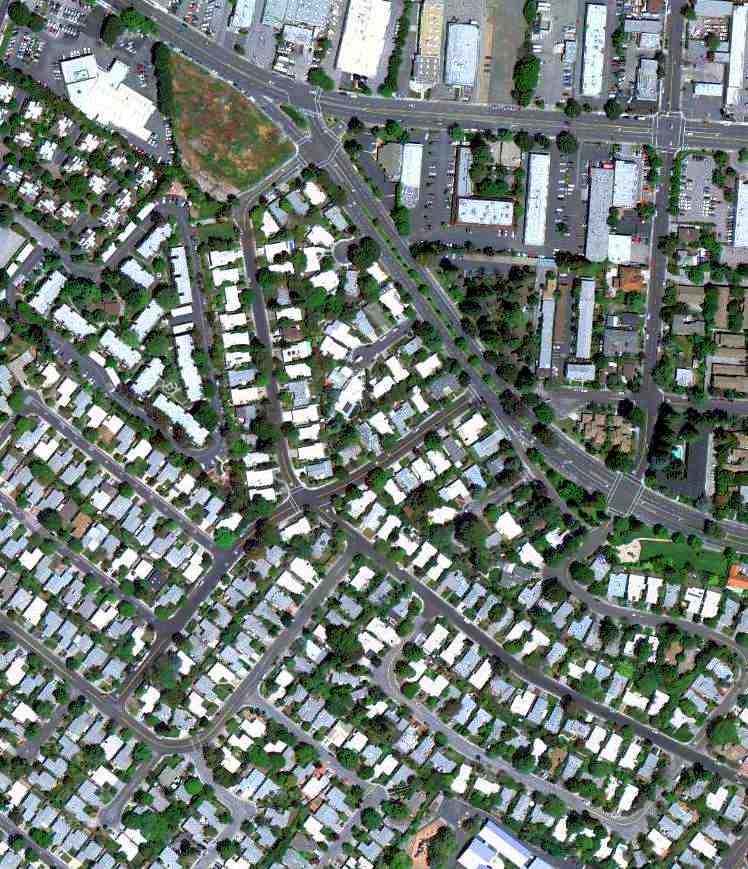
A 5/2/11 aerial view showed no remaining recognizable trace of Mountain View Airport.
The site of Mountain View Airport is located southeast of the intersection of San Antonio Road & West Middlefield Road.
____________________________________________________
NOLF Abel / NOLF Coelho / Warm Springs Airport (2nd location), Warm Springs, CA
37.456, -121.906 (Southeast of San Francisco, CA)
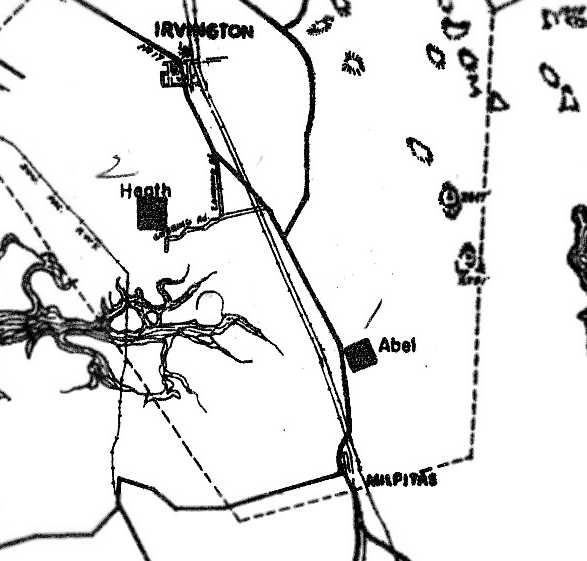
A 1943 diagram (courtesy of Brian Rehwinkel) depicted Abel simply as a square-shaped outline.
No airfield was depicted at this location on the 1941-44 San Francisco Sectional Charts.
During World War II, an Outlying Landing Field was established called Abel OLF.
According to Brian Rehwinkel it had a 2,500' turf runway.
Brian Rehwinkel reported, “Abel OLF is mentioned as early as December 1941 in Navy documents for Naval Reserve Aviation Base Oakland as one of the fields to be used by that station.
When the primary training was moved to the new Livermore station in 1942, some of the fields used by the Oakland station were abandoned and some new fields (closer to Livermore) were opened.”
The earliest depiction which has been located of the Abel airfield was a 1943 diagram (courtesy of Brian Rehwinkel) which depicted Abel simply as a square-shaped outline.

The earliest photo which has been located of Abel OLF was a 1943 aerial view from the 1943 NAS Livermore Air Operations Manual (from the National Archives, courtesy of Brian Rehwinkel).
Brian Rehwinkel noted, it “shows the boundaries & distances for Abel Field (also known as '"Field A').

The only photo which has been located showing aircraft at Abel OLF was a 7/1/44 USN aerial view looking north (from the National Archives, courtesy of Brian Rehwinkel).
It depicted 6 trainer biplanes on the field, and Brian Rehwinkel noted it “gives an idea of how sparsely populated this area was in 1944.”
The 1944 Army/Navy Directory of Airfields (courtesy of Jonathan Westerling)
listed “Abel OLF, Navy” as having a 3,800' unpaved runway, and being an Outlying Landing Field to NAS Livermore.

At some point between 1943-44, Heath OLF evidently was renamed “Coelho”, as that is how it was labeled on the August 1944 San Francisco Sectional Chart.
According to Brian Rehwinkel, Coelho was “the name of the other property owner the Navy purchased the land from.”
Abel was not listed in the 1945 AAF Airfield Directory (courtesy of Scott Murdock).
According to Jonathan Westerling, “After the war, aviation use of Abel OLF was continued as a public airport.”
Jonathan recounted a story told to him in 2010: “Bill Bastida was in high school just after WWII.
He & his buddies would fly model airplanes at the airport that had been NOLF Abel (he referred to it as 'Milpitas Airport').
Occasionally one of his friends skip lunch & use their lunch money to save up for a glider ride at the airport (he remembers they cost $1.50).
On one of these occasions, his friend told Bill to hop in with the tow pilot while his glider was taken into the sky.
The pilot didn’t mind & that’s how Bill got his first ride in an airplane.
Unfortunately Bill’s mother showed up at the airport just after the tow plane took off with him in it.
When the plane landed, Bill remembers seeing someone in a dress running toward the plane.
It had barely stopped taxiing when his mom pulled him out of the passenger seat by his ear
and dragged him home with the warning that he never go up in an airplane again.
Bill got his private pilot license a few years later.”
According to the history of the Northern California Soaring Association (courtesy of Jonathan Westerling):
“The spring of 1947, saw a group of soaring enthusiasts gather at the beautiful grass strip known as Warm Springs Airport, to decide on how to form a glider club.
Fellows from Ames Research & Lockheed who loved to fly, felt by pooling their money to purchase a glider, they could start a club.
Warm Springs Airport was located at the southern end of Mission Ridge, easy towing & landing when soaring on the long ridge.
While at Warm Springs, the club held 2 soaring contests.
Some of the gliders attending the first one were; 2 slick LK’s (Lister-Kaufmann), a swell Pratt Reid (side by side),
the Ames club TG-3, Les Arnold’s TG-3 Redwing, and Ted Nelson’s Hummingbird.
Ralph & Betty Salisbury, the operators of the field, lived above the large hangar, were very friendly folks who loved the glider activity.
However, Ralph always wanted to fly for an airline, he went to work flying for United Airlines.
Derrill 'Gabby' Hansen who worked over at Ames Research became the airport manager while Ralph was away.
The group grew, having a great time learning the soaring conditions of the Bay Area.
However, into the second year at Warm Springs Airport, the owner of the field would not renew the lease, the group was forced to move.”
The 1948 Haire Airport Directory (courtesy of David Brooks) described “Warmsprings Airport” as a private field offering training, charter, major repairs, and field.
It was said to have a 2,300' “all-way unpaved” landing area.
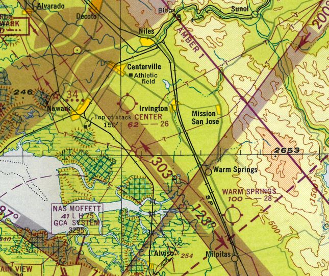
The 1948 San Francisco Local Aeronautical Chart (courtesy of Tim Zukas) depicted Warm Springs Airport as having a 2,800' unpaved runway.
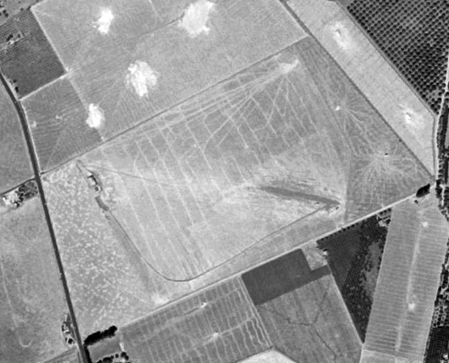
The 1948 USGS aerial photo (courtesy of Brian Rehwinkel) depicted Warm Springs Airport as having an unpaved runway.
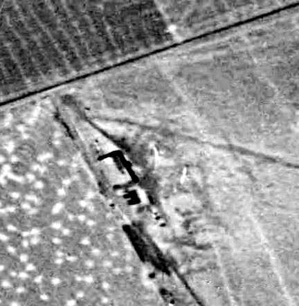
A closeup from the 1948 USGS aerial photo (courtesy of Brian Rehwinkel) showed the hangar along with what appeared to be 2 gliders on the field.
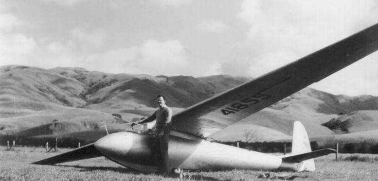
A 1949 photo of a DFS Meise at Warm Springs.
According to Jonathan Westerling, “As a historical side note,
the town of Warm Springs was officially spelled Warmsprings until 1950 when it changed to 2 words.”
Jonathan Westerling reported, “Warm Springs Airport continued operation for several more years mostly as a glider port.”
The 1951 Airman’s Directory (courtesy of Jonathan Westerling) listed “Warm Springs”
as having a 2,800' all-way turf landing field - “perfect for gliders”.
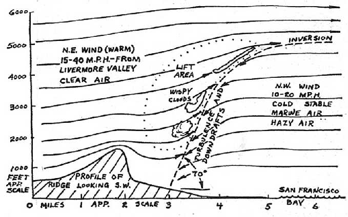
A diagram of the air currents over the Warm Springs Gliderport
from the July 1951 issue of Soaring Magazine (reused with permission from the Soaring Society of America).
An article by Emil Kissel entitled “Soaring waves at Warm Springs Airport” appeared in the magazine.
It described the thermal differences between the ocean & inland temperatures which led to favorable soaring conditions near the airfield:
“Cold stable marine air causes a haze condition that fooled us on the ground at Warm Springs into believing that there was no soaring.
However, these winds collide about 1 mile from the ridge & produce strong downdrafts
in the hazy air & smooth steady lift in the clear air.”
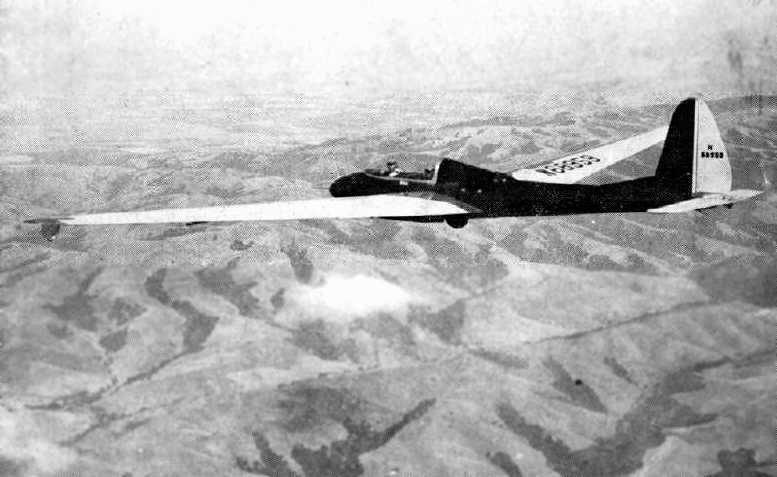
An undated photo of a glider from the Nov/Dec 1951 issue of Soaring Magazine (reused with permission from the Soaring Society of America).
It was captioned, “Ted Nelson & Harry Perl in the Hummingbird over the hills near Warm Spring Gliderport, CA.”
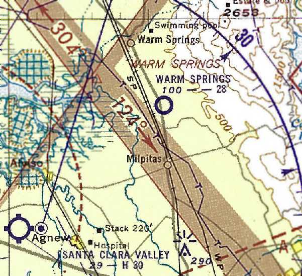
The last aeronautical chart depicted which has been located of Warm Springs
was on the 1952 San Francisco Local Aeronautical Chart (courtesy of Jonathan Westerling).
It depicted Warm Springs as having a 2,800' unpaved runway.
According to Jonathan Westerling, “Unfortunately for the glider pilots,
the housing boom in the East Bay during the mid-1950s spelled the rapid demise of the Warm Springs Airport.
The last recorded mention of the airfield is in the annals of the Pioneer R/C Club which used Warm Springs Airport as its flying site.”
Their history reads, “This field was used until October 1952 when it was closed to [the] flying of gliders & [remote control] airplanes.”
The 1953 USGS topo map no longer depicted Warm Springs Airport.
Jonathan Westerling reported, “According to USGS aerial photos, houses were built over most of the airfield in 1953.”
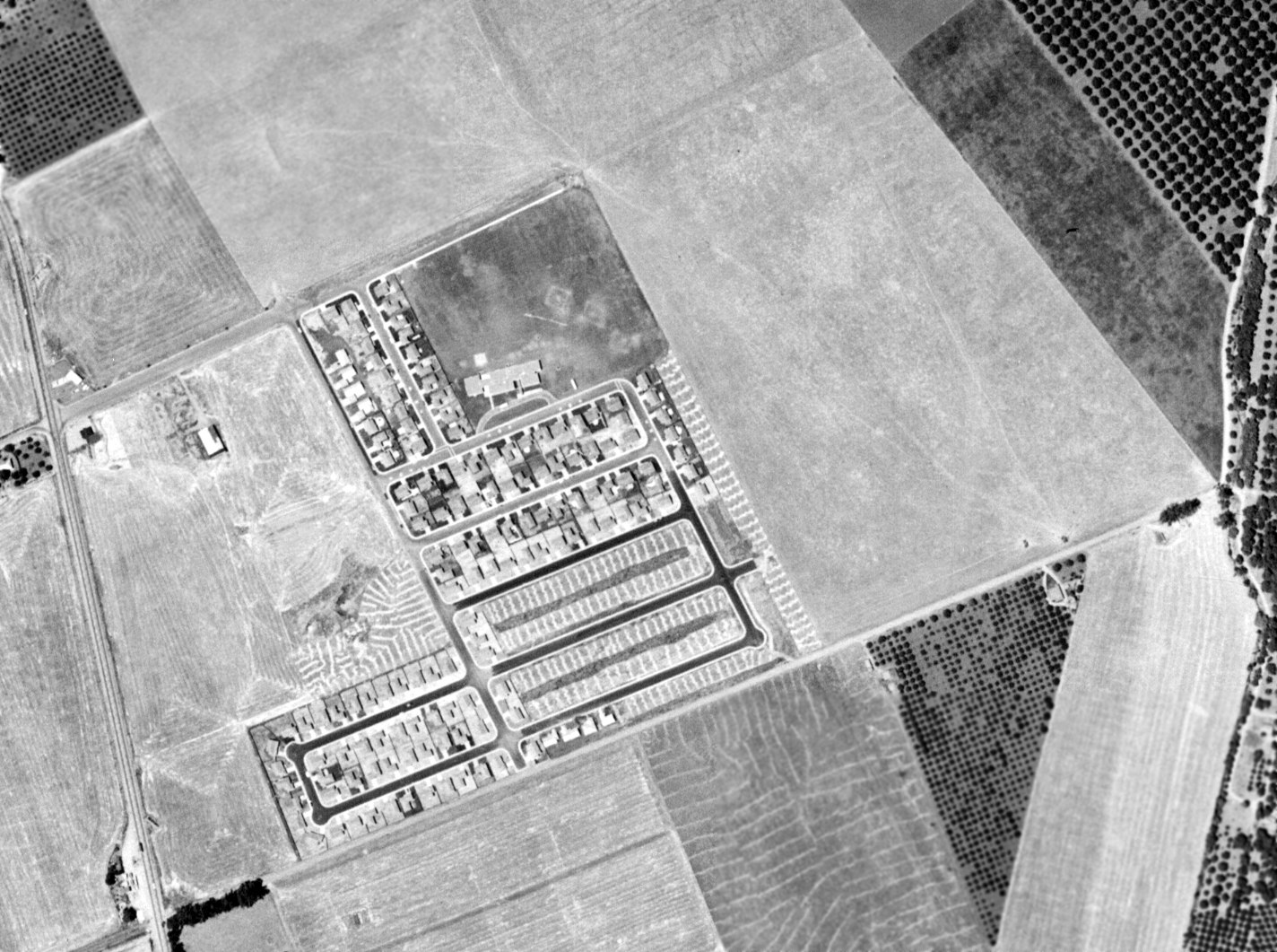
A 1956 aerial photo (from the UCSB Library, courtesy of Jonathan Westerling) showed houses having been built over the center of Warm Springs Airport,
but the hangar remained standing on the west side.
Jonathan Westerling reported, “The single hangar at Warm Springs was razed between 1959-66.”
Jonathan Westerling reported in 2009, “The site of Warm Springs Airport is today a residential area centered around Albert Augustine Park in Milpitas.”
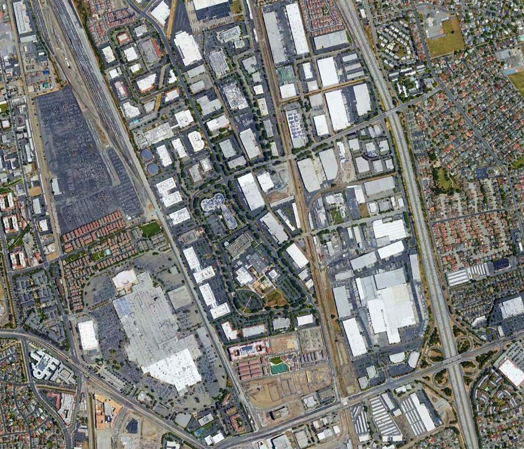
A 2017 aerial view showed no remaining recognizable trace of Warm Springs Airport.
____________________________________________________
37.52, -122.25 (Southeast of San Francisco, CA)
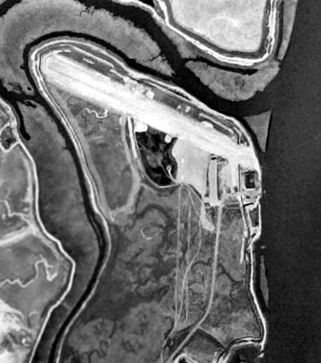
Cooley Field, as depicted on the 1946 USGS aerial photo (courtesy of Jonathan Westerling).
According to Jonathan Westerling, “Right after the Second World War, William Cooley established his own airfield
on a peninsula jutting out to the bay about a half mile northeast of another airfield owned by his father [Frank Cooley].
By 1946, a runway had been built & several planes were based at the field.”
The earliest photo which has been located of Cooley Field was the 1946 USGS aerial photo (courtesy of Jonathan Westerling).
It depicted Cooley Field as having a unpaved northwest/southeast runway,
along with the outline of a never-completed north/south crosswind runway.
A single large hangar was located at the southeast end of the runway, along with 2 light airplanes.
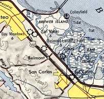
The 1947 USGS topo map (courtesy of Jonathan Westerling)
depicted Cooley Field as well as 4 other airports & a seaplane base all within a 2 mile area.
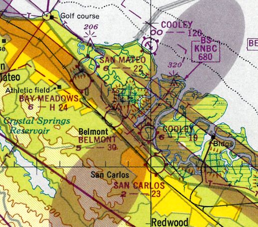
The earliest aeronautical chart depiction which has been located of Cooley Field
was on the February 1948 San Francisco Local Aeronautical Chart (courtesy of Tim Zukas).
It depicted Cooley Field as having a mere 1,900' unpaved runway.
The Cooley Airport was established & managed by William Cooley,
according to the 1948 Haire Airport Directory (courtesy of David Brooks).
The 1949 Bay Area Airport Survey (according to Jonathan Westerling)
described Cooley Field as having a 2,000' paved runway, with 23 based aircraft & tiedowns for 80 planes.
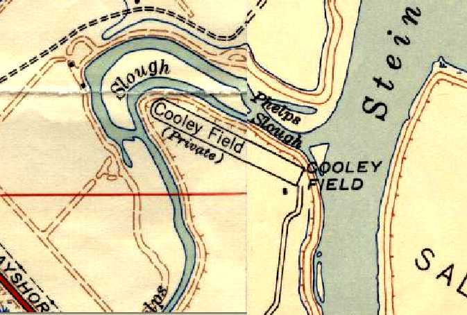
A composite of the 1948 & 1949 USGS topo maps (courtesy of Jonathan Westerling)
depicted Cooley Field as a private field having a single northwest/southeast runway,
with a single building at the southeast corner.
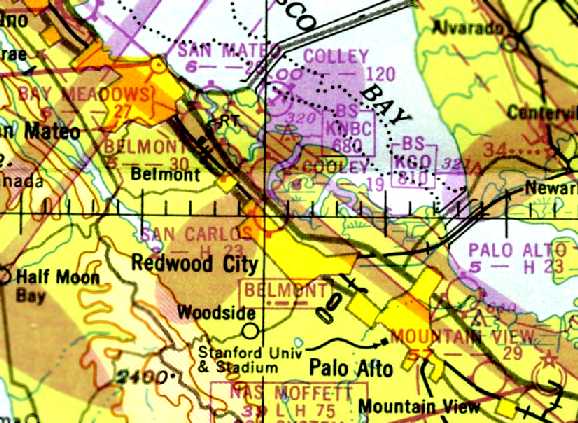
The last aeronautical chart depiction which has been located of Cooley Field
was on the 1949 Sectional Chart (courtesy of Chris Kennedy).
It depicted Cooley Field as having a 1,900' unpaved runway.
According to Jonathan Westerling, “In 1950 the city of San Carlos built a new airfield
located halfway in between the original San Carlos Airport & Cooley airfield.
When it was completed, the 2 airfields effectively merged into the new airport which exists to this day.”
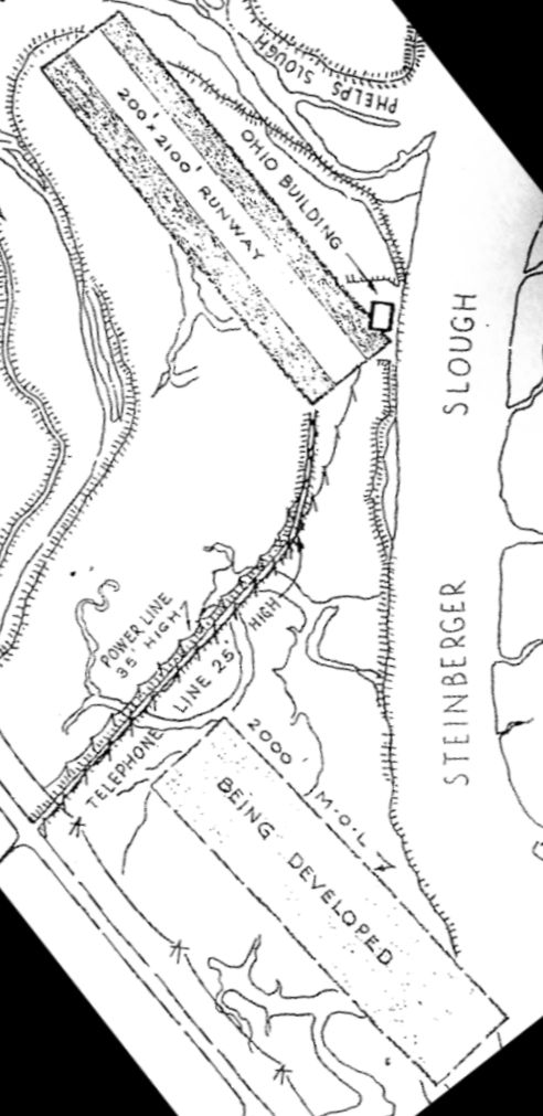
A March 1950 map (courtesy of Jonathan Hull) depicted Cooley Field (at top) having a 2,100' northwest/southeast runway, with the “Ohio Building” being depicted on the east corner,
along with the San Carlos Airport “being developered” to the south.
The 1951 Airman's Guide (courtesy of Jonathan Westerling) still listed Cooley Field as an active airfield, with a 1,900' runway.
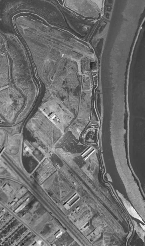
The last photo which has been located of Cooley Field
was the 1956 USGS aerial view (courtesy of Brian Rehwinkel).
Cooley Field was still intact (at the top of the photo), although no planes were visible on the field.
It also showed the new, larger San Carlos Airport which has been built to the south.
Jonathan Westerling observed, “By 1968 the Cooley airfield had been torn up
and was being developed into the 'Redwood Shores' housing & office park according to a USGS photo.”
Jonathan Westerling reported in 2009 of Cooley Field, “Today, no physical remnants of the airfield exist.”
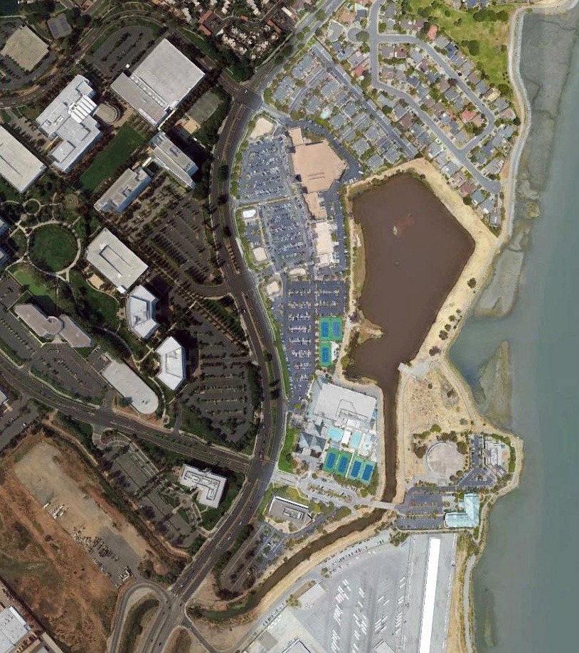
A 2017 aerial view showed no remaining recognizable trace of Cooley Field.
The site of Cooley Field is located at the intersection of Shearwater Parkway & Redwood Shores Parkway.
Thanks to Chris Kennedy for pointing out this airfield.
____________________________________________________
Santa Clara Valley Airport, Santa Clara, CA
37.39, -121.99 (Northwest of San Jose, CA)
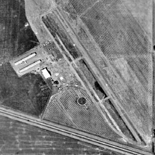
A 1948 aerial view depicted the Santa Clara Valley Airport as having a single northwest/southeast paved runway.
Just after World War II, 10 investors bought 250 acres in Lakewood Village
and built the Santa Clara Valley Airport (according to the Lakewood Village Neighborhood Association).
The land was graded for a single runway with a parallel taxiway & a ramp on the west side,
and a single hangar was constructed with a mechanic’s shop & a small office.
George Brown recalled, “One of the 10 investors who started the Santa Clara Valley Airport was my grandfather, Walter Brown.
As a kid I clearly remember my father, George Brown, taking me out to the airport - to go flying, talk to others, etc.
He was a WW2 fighter pilot in the Pacific Theater. Eventually he bought a Stinson Station Wagon which he complexly restored.
I believe that the field support crop dusters in it's days.
We had a small concrete pad halfway down the main strip to load the planes - they would land at the threshold, get off at the pad,
then get back on & use the rest of the runway for take off - a far cry from today.
Eventually we graded a dirt strip on Lafayette Street just north of Agnew & the crop dusters worked from there.
Wayne Clevengar owned the company - flying old Stinson observation planes from WW2, with a second (lower) wing added & repowered with big radial engines.
Crop duster operations eventually moved to the San Jose Muni Airport.”
No airfield at this location was depicted on the February 1948 San Francisco Local Aeronautical Chart (courtesy of Tim Zukas).
The earliest chart depiction of the Santa Clara Valley Airport which has been located was a 1948 aerial view.
It depicted the field as having a single northwest/southeast paved runway with a parallel taxiway.
Three hangars were located on the west side of the field, around which were parked a dozen light aircraft.
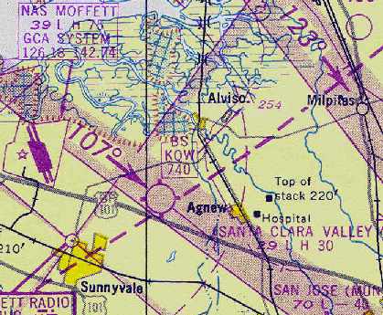
The earliest chart depiction of the Santa Clara Valley Airport which has been located
was on the March 1949 San Francisco Local Aeronautical Chart (courtesy of Chris Kennedy).
It depicted the field as having a 3,000' hard-surface runway.
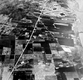
A circa late 1940s - early 1950s aerial photo looking northwest (courtesy of Arleigh Movitz),
showing the relationship of the Santa Clara Valley Airport (lower-left) to Moffet Field (top-right).
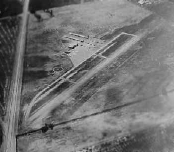
A circa late 1940s - mid 1950s aerial view looking northwest at the Santa Clara Valley Airport (courtesy of Arleigh Movitz).
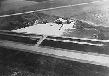
A circa late 1940s - mid 1950s aerial view looking southwest at Santa Clara Valley's ramp & hangar (courtesy of Arleigh Movitz).
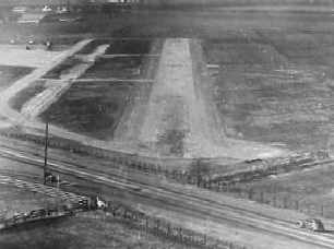
A circa late 1940s - mid 1950s aerial view looking along final approach to the Santa Clara Valley Airport (courtesy of Arleigh Movitz).
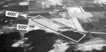
An undated aerial view looking north at Santa Clara Valley Airport in the 1950 Air Photo Guide (courtesy of Kevin Walsh).
The guide described Santa Clara Valley Airport as having a 2,900' hard surface runway, and listed the manager as Robert Liddell.
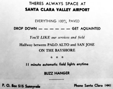
An advertisement for Santa Clara Valley Airport from the 1950 Air Photo Guide (courtesy of Kevin Walsh).
The 1952 San Francisco Local Aeronautical Chart (courtesy of Jonathan Westerling)
depicted the Santa Clara Valley Airport as having a 3,000' paved runway.
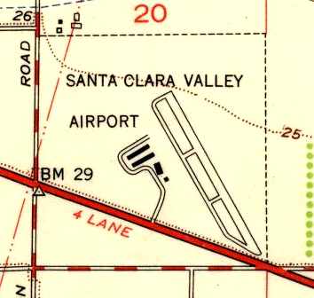
The 1953 USGS topo map depicted Santa Clara Valley Airport as having a single 2,000' runway,
with a parallel taxiway on the southwest side, and a total of four buildings (hangars?) along the west side of the field.
The Aerodromes table on the September 1954 San Francisco USAF Sectional Chart (according to Chris Kennedy)
described the Santa Clara Valley Airport as having a single 3,000' bituminous runway.
Unfortunately, less than a decade after it had opened, the life of the Santa Clara Valley Airport started to draw to a close.
In 1954 the City of Sunnyvale launched a plan to annex 129 acres from the County,
including the airport property, at the northeast corner of Lawrence Station Road & Bayshore Highway.
This annexation was intended to enable development of the property, and it took place the following year.
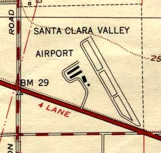
The 1955 USGS topo map depicted the Santa Clara Valley Airport in an identical fashion as on the 1953 topo map.
In what would become a common story for many post-WW2 general aviation airports,
the land of the Santa Clara Valley Airport was sold for development in 1955, and the airport presumably closed in the same year.
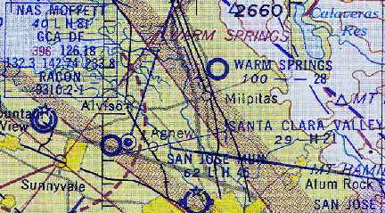
Although the Santa Clara Valley Airport was still depicted
on the March 1955 San Francisco Sectional Chart (according to Chris Kennedy),
the Aerodromes table said that the field was already "Closed to all operations."
The runway length had already been reduced somewhat,
as it was described as a single 2,100' bituminous strip with a total of 2,900' available.
The Oakmead Fire Station occupied a former Santa Clara Valley Airport hangar (donated by Arthur Monte) for one year,
until a replacement station was built.
By the time of the March 1956 San Francisco Sectional Chart (according to Chris Kennedy),
Santa Clara Valley Airport was no longer depicted at all.
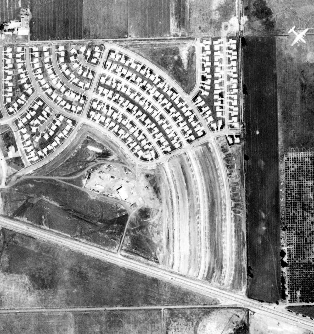
A 1956 aerial view (from the Alexandria Digital Library @ UCSB, courtesy of Jonathan Westerling) showed that the site of Santa Clara Valley Airport had already been covered by housing.
However the former hangar (used by the Fire Department) still remained at the site (just below the center of the picture).
According to Rick Turner, “After the Sunnyvale Fire Department was through with it,
Mike Coutches purchased the hangar, dismantled it & moved it to the Hayward Airport.
Since 1958 the former Santa Clara Valley Airport hanger has been use by Mike's American Aircraft Sales at Hayward.”
By the time of the 1961 USGS topo map, Santa Clara Valley Airport had been replaced by a network of new residential streets & the Fairwood School.

A 1965 aerial view (from the Alexandria Digital Library @ UCSB, courtesy of Jonathan Westerling) showed that the site of Santa Clara Valley Airport had been further covered by housing,
but the foundation of the former hangar still remained (just below the center of the picture).
A 1968 aerial view showed no remaining trace of the Santa Clara Valley Airport.
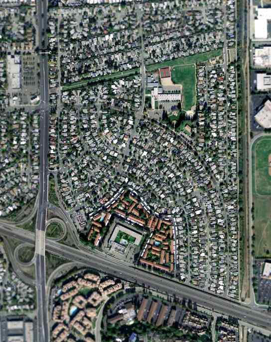
As seen in the February 2004 USGS aerial photo, not a trace appears to remain of Santa Clara Valley Airport.
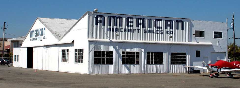
A 2007 photo (courtesy of Rick Turner) of the former Santa Clara Valley Airport hangar,
as it has been reused as American Aircraft Sales at the Hayward Airport.
The site of Santa Clara Valley Airport is located northeast of the intersection of Interstate 101 & the North Lawrence Expressway.
Thanks to Arleigh Movitz for pointing out this airfield.
____________________________________________________
Centerville Airport / Center Field, Centerville, CA
37.53, -121.99 (East of San Francisco, CA)
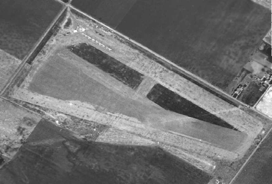
A 1946 aerial photo depicted Centerville Airport as having a northwest/southeast unpaved runway.
This general aviation airport was one of the hundreds of such fields
which were established across the U.S. in the period immediately after the end of WW2.
And like many of those fields, it did not last long,
as surrounding development squeezed the airport out of business.
Centerville Airport was evidently established at some point between 1945-46,
as it was not yet depicted at all on the March 1945 San Francisco Sectional Chart (according to Chris Kennedy).
The earliest depiction of Centerville Airport which has been located was a 1946 aerial photo.
It depicted Centerville Airport as having a northwest/southeast unpaved runway.
There did not appear to be any hangars, but a total of 10 single-engine aircraft were visible on the north side of the field.

The earliest ground-level photo which has been located of Centerville Airport was a March 1946 photo by Bill Larkins (courtesy of Jay Sherlock) of NC13401, a 1933 Waco PLA Sportsman.
The earliest aeronautical chart depiction which has been located of Center Field
was on the 1948 San Francisco Local Aeronautical Chart (courtesy of Tim Zukas).
It depicted Center Field as having a 2,600' unpaved runway.
A 1948 aerial view showed that several hangars had been erected on the north side of the field,
and the number of aircraft visible on the field had increased to 16.
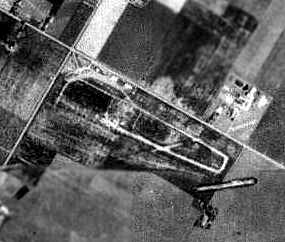
A 1950 aerial view from the Alexandria Digital Library @ UC Santa Barbara (courtesy of Jonathan Westerling)
depicted Centerville Airport as having a single northwest/southeast runway with a parallel taxiway,
and several small buildings along the north side of the field.
Neil Burkhart recalled, "My father in-law was a long time resident of Fremont, he moved there in the early 1950s.
He told me 'The Airport' was originally off the South side of Mowry Avenue
at the location of the current Albertsons / SaveOn Superstore near Blacow.
He said there were lots of glider ops out of it when it was on Mowry as well."
The 1952 San Francisco Local Aeronautical Chart (courtesy of Jonathan Westerling) depicted “Center” as having a 2,500' unpaved runway.
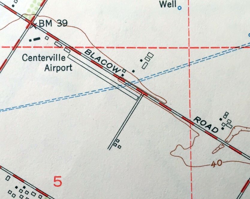
The 1953 USGS topo map (courtesy of Kevin Walsh) depicted Centerville Airport as having a single northwest/southeast runway, parallel to the south side of Blacow Road.
This had replaced the considerably wider runway area to the southwest.
A few small hangars were depicted on the northwest corner of the field, along the south side of Blacow Road.
The field was evidently renamed "Center" within the next year,
as that is how it was depicted on the September 1954 San Francisco USAF Sectional Chart (courtesy of Chris Kennedy).
The runway length had also been reduced somewhat, to only 2,000'.
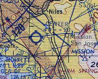
Center Field was still depicted with a 2,000' unpaved runway on the March 1956 San Francisco USAF Sectional Chart (courtesy of Chris Kennedy).
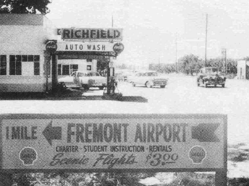
An undated (1956 or later) sign for the "Fremont Airport", from "Fremont - The first 30 years" (courtesy of Timothy Swenson).
Although the sign says "Fremont Airport", it was supposedly located at the corner of Fremont Boulevard & Mowry Boulevard,
so it was presumably referring to the field which was otherwise known as "Centerville Airport".
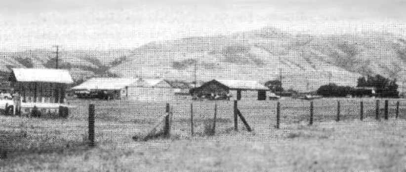
An undated (circa 1950s?) view of planes at hangars from "Fremont - The first 30 years" (courtesy of Timothy Swenson).
Although the picture is supposedly of the "Fremont Airport", it was presumably referring to the field which was otherwise known as "Centerville Airport".
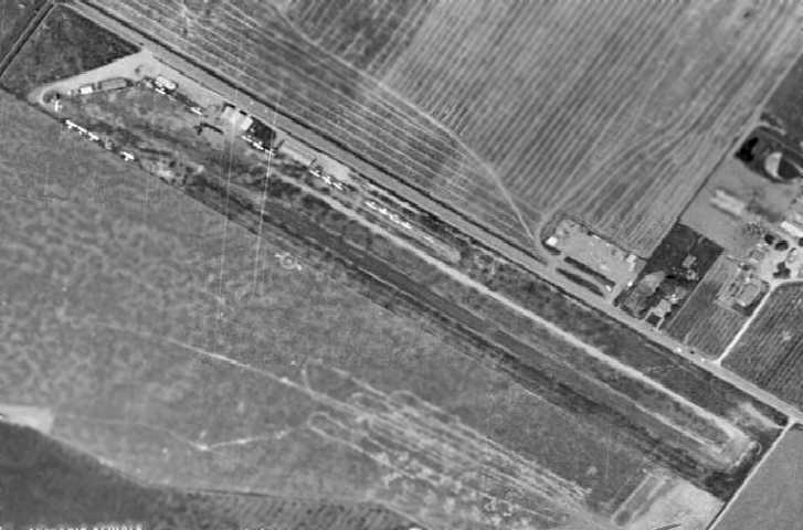
A 1959 aerial view showed that the size of the Centerville Airport property had shrunken drastically,
with the area to the south of the runway evidently no longer part of the airport.
The runway was by that point a narrow strip, very close to the road.
The number of aircraft on the field had grown to 20, but the airport's days were obviously numbered.
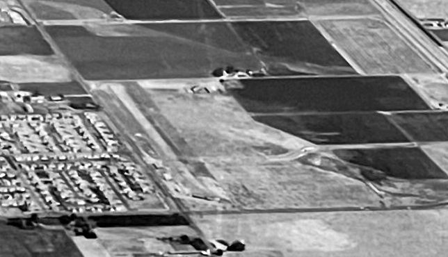
A circa late 1950s aerial view looking south showed the single runway of Centerville Airport (courtesy of Kevin Walsh).
Center Field was listed in the 1960 Jeppesen Airway Manual (according to Chris Kennedy) as having a single 2,000' unpaved runway.
Douglas Bauer recalled, “I flew out of Centerville Airport when I started taking glider lessons at 13 1/2 years old [1960] with Les Arnold at his Sky Sailing operation in 1960.”
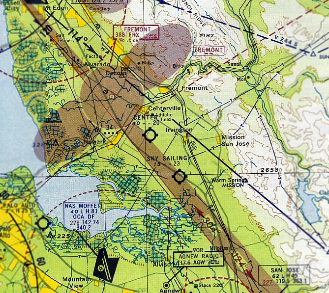
The last depiction which has been located of Center Airport was on the March 1961 San Francisco Local Aeronautical Chart.
It depicted Center Airport as having a 2,000' unpaved runway.
Center Airport was apparently closed at some point between 1961-62,
as it was no longer depicted on the 1961 USGS topo map
or the October 1962 San Francisco Local Aeronautical Chart (according to Chris Kennedy).
A 1966 aerial view showed that housing had covered the southeastern part of the former Center Airport.
The hangars still remained standing on the northwestern part, for the time being.
A 1979 aerial view showed that the former hangars had been covered by a large building,
erasing any trace of Centerville Airport.
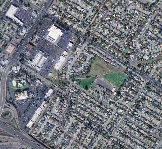
As seen in the February 2004 USGS aerial photo, not a trace appeared to remain of Centerville Airport.
The site of Centerville Airport is located on the south side of Blacow Avenue, southeast of its intersection with Mowry Avenue.
____________________________________________________
Hummingbird Haven, Livermore, CA
37.7, -121.69 (East of Oakland, CA)
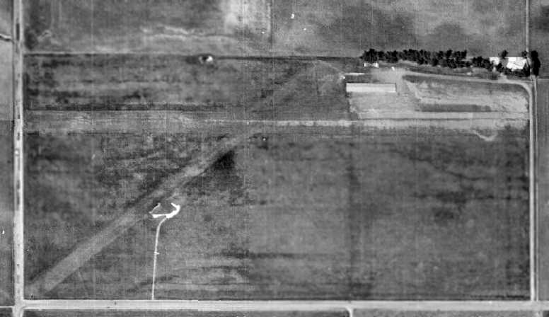
A 1959 aerial view depicted Hummingbird Haven as having 2 unpaved runways, with a single hangar on the northeast side of the field.
No airfield was yet depicted at this location on a 1949 aerial view.
Hummingbird Haven was a small gliderport located right next to the Livermore National Laboratory.
It began operation in 1955 (according to Jonathan Westerling).
It consisted of a gravel & grass 2,500' East/West runway, along with 2 hangars.
The name of the field came from a motorglider called the Hummingbird - one of the earliest motor gliders.
According to Toodie Perl-Marshall of the Northern California Soaring Association,
"In 1956, the NCSA & Ames soaring club was invited to move to Hummingbird Haven, home of Alice-Ted & Jerry Nelson.
Ted had acquired 80 acres at the corner of Greenville Road & Patterson Pass Road in Livermore.
Stan Hall built us a wonderful tetrahedron that stood for the 34 years we operated there; 'One Never Landed Against the Tetrahedron!'
Hummingbird Haven was a wonderful location for the NCSA & Ames Club, we had a club house, pool & picnic area for the families."
Toodie continued, "What a wonderful soaring site that was for all of us.
All the types of soaring were found in the Livermore valley, we had wave in the summer over the Del Valle reservoir, wave over Mt. Diablo in winter,
thermals, ridge lift & beautiful cumulus clouds after a front passed.
All of us that have seen one another over the years all feel this was such a special time to be a glider pilot."
The earliest photo which has been located of Hummingbird Haven was a 1959 aerial view.
It depicted the field as having 2 unpaved runways, with a single hangar on the northeast side of the field.
There were no aircraft visible parked outside.
Douglas Bauer recalled, “I have flown out of Hummingbird Haven.
Ted Nelson, the developer of the Hummingbird sailplane, also developed Hummingbird Haven. It neighbored the UCB nuclear labs.”
A 1966 aerial view showed Hummingbird Haven in basically an unchanged manner.
Arthur Snyder recalled, “My father Charles 'Mac' Snyder flew out of Humming Bird for years.
Once when the wind was blowing from the east, he ended up having to land under the power wires.
Ted Nelson had a pool behind his house & he let us kids use it while our father flew.”
Hummingbird Haven was not yet depicted on the June 1968 San Francisco Sectional Chart or the 1975 USGS topo map.

A 9/17/74 USGS aerial showed Hummingbird Haven to have 2 unpaved runways & 2 hangars, but no aircraft visible on the field.
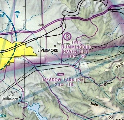
The earliest aeronautical chart depiction which has been located of Hummingbird Haven was on the 1975 San Francisco Terminal Chart.
It depicted Hummingbird Haven Gliderport as a private airfield having a 2,600' unpaved runway.
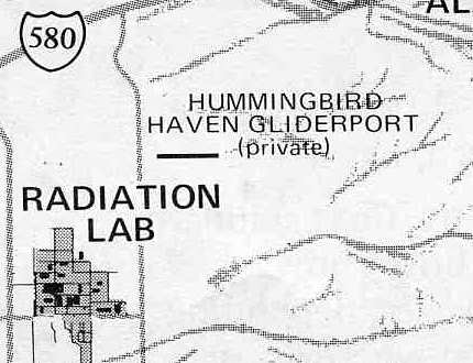
Hummingbird Haven, as depicted on the 1976 Pilot's Guide to CA Airports (courtesy of Chris Kennedy).
It no longer depicted the northeast/southwest runway, just the east/west runway.
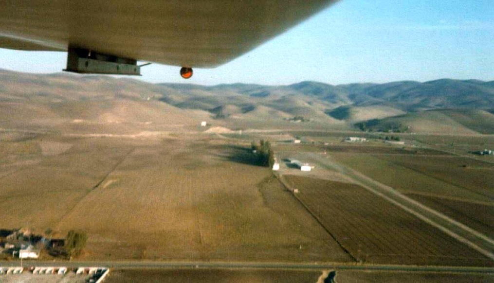
A Fall 1976 photo by Kempton Izuno of Hummingbird Haven from the back seat of the Ames Club Ka-7 on the base leg.
A 1979 aerial view showed that a 2nd hangar had been added to the northeast side of the field at some point between 1966-79.
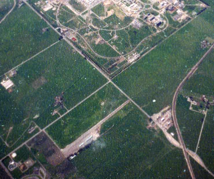
A 1980 aerial view by Dick Jones looking southwest with Hummingbird Haven at the bottom,
and Lawrence Livermore National Laboratory (the former NAS Livermore) at the top.
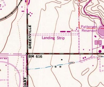
The 1981 topo map depicted Hummingbird Haven as a single unpaved east/west runway, labeled simply as “Landing Strip”.

A 4/19/81 USGS aerial showed Hummingbird Haven to have 2 unpaved runways & 2 hangars, but no aircraft visible on the field.
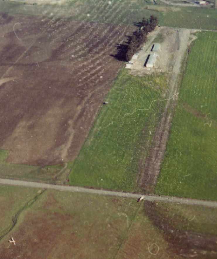
A 1982 aerial view by Dick Jones looking east at Hummingbird Haven, with a glider on the ground at the bottom-left.
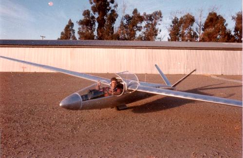
A 1980s photo by Richard Gaines (via Jonathan Westerling) of Dr. Gains' beautiful HP-14 sailplane on the ramp at Hummingbird.
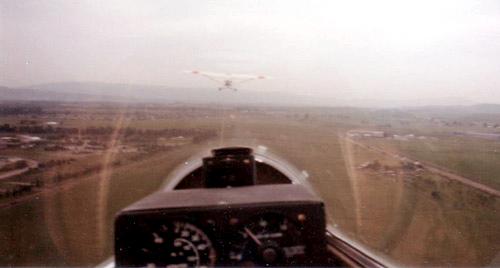
A circa 1980s photo by Richard Gaines (via Jonathan Westerling) of a takeoff from Hummingbird Haven to the west.
Note the boundary of Livermore Labs to the left.
Dr. Richard Gaines recalled that there were no problems with Livermore Labs
despite the runway being adjacent to such a high security facility.
"There were no problems with the lab.
Our takeoff was a straight-out & that path went just north of the lab boundary.
So if we turned south we would fly into the lab & that was not done.
We did have trouble with a power line that went across the end of the departure runway. That was scary.
When it got bad was towing a 2-place sailplane which were always heavier & heading right at the power lines.
We came very close sometimes. We tried repeatedly to get the line buried but it never happened.
I was a tow pilot as well as flying sailplanes. I think that there were about 28 members & 8 of us took turns towing.
We only operated on weekends so on very good weekends the lines for tows could be quite long (2 hours)
and it was a real workout for the tow pilot.
I think the most tows I did in one day was 28 or 30."
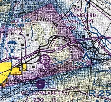
Hummingbird Haven, as depicted on the 1985 San Francisco Sectional Chart (courtesy of Dann Shively).
Hummingbird Haven was closed (for reasons unknown) in 1989.
According to Jonathan Westerling, its hangars were mostly disassembled & moved to the Hollister Airport,
where they are apparently still in use today.
Toodie Perl-Marshall recalled, "The field closed because Ted had sold it to a development company & they told us to move.
Obviously there was never any development, I fly into Livermore on many occasions,
and its with a sad heart seeing what has happened to the valley as HH. Rich Gaines & I were good friends."
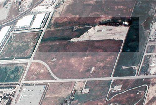
An aerial view of Hummingbird Haven from the late 1980s (courtesy of Livermore Airport, via Jonathan Westerling).
A new road had been built over the southwest portion of the site, but the outline of the 2 former runway was still barely recognizable.
A 1993 aerial view showed that the Hummingbird Haven hangars were gone.
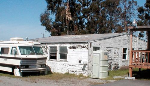
A 2003 photo by Jonathan Westerling of the remains of the office/hangar at Hummingbird Haven.
Note the word "ONLY" painted on the roof - it used to read "GLIDERS ONLY" when the building was intact.
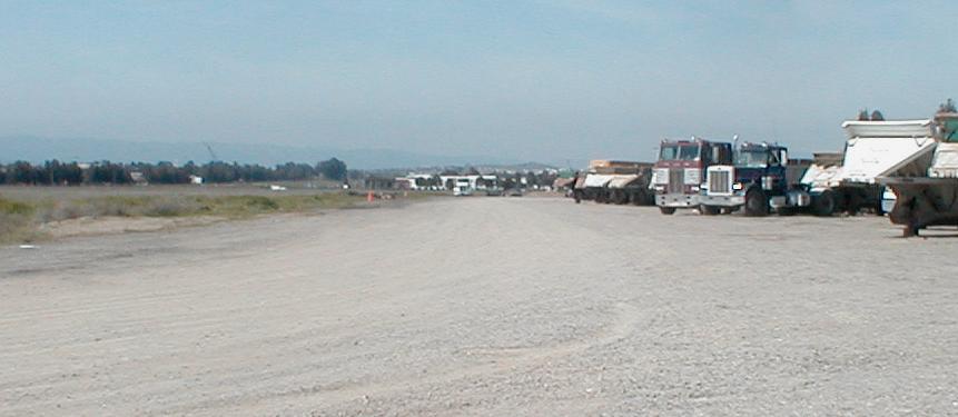
A 2003 photo by Jonathan Westerling looking west along the remains of the runway at Hummingbird Haven.
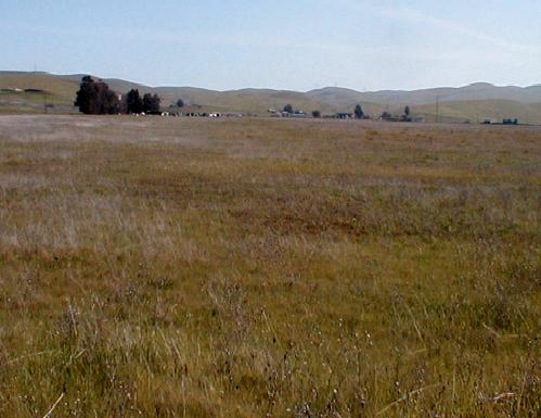
A 2003 photo by Jonathan Westerling looking east along the remains of the runway at Hummingbird Haven.
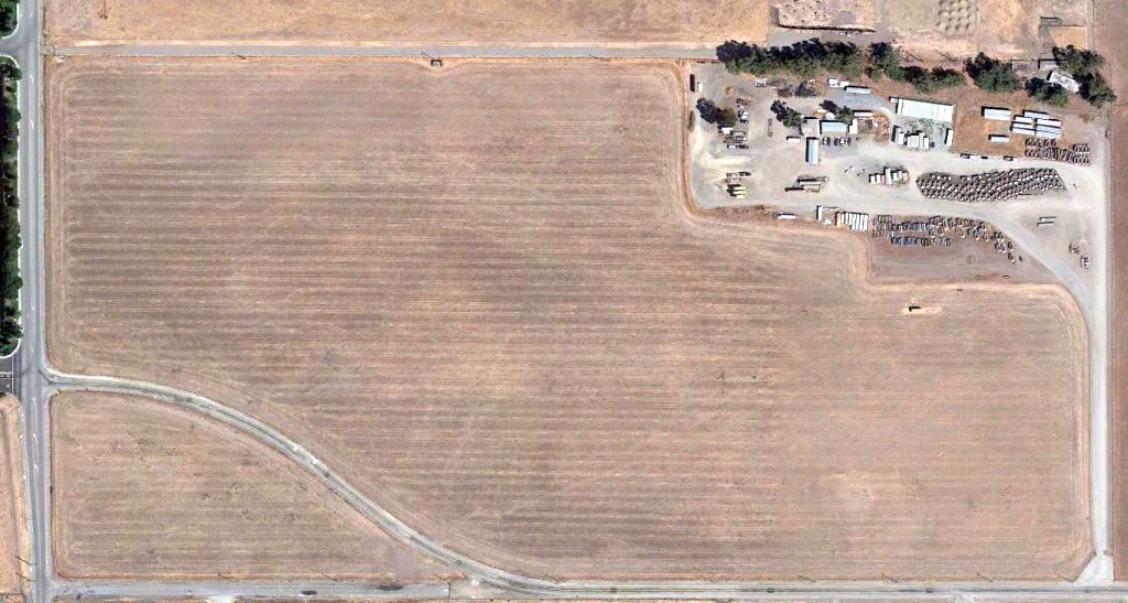
In an 8/28/12 aerial photo the Hummingbird Haven site had been returned to cultivation, and it was no longer recognizable as a former airfield.
____________________________________________________
____________________________________________________
This site covers airfields in all 50 states.