
Abandoned & Little-Known Airfields:
California: Southern Santa Rosa Area
© 2002, © 2023 by Paul Freeman. Revised 9/8/23.
This site covers airfields in all 50 states: Click here for the site's main menu.
For a 10th year, the CA pages of this website are sponsored by the California Pilots Association:
____________________________________________________
Please consider a financial contribution to support the continued growth & operation of this site.
Buck Airport / Pingpank Airport / Doolittle Petaluma Airport (added 9/6/23) - Cotati NOLF (revised 11/27/21)
Justman Airport (added 9/8/23) - Oak View Airport (added 9/8/23) - Petaluma Airport (added 9/7/23) - Petaluma Sky Ranch Airport (added 9/8/23)
____________________________________________________
Buck Airport / Pingpank Airport / Petaluma Doolittle Airport, Petaluma, CA
38.249, -122.611 (North of San Francisco, CA)
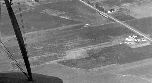
A post-1925 aerial view of Buck Airport.
Terry Park reported, “Petaluman George Buck, a licensed pilot, formed a partnership with mechanic Lawrence “Pinky” Pingpank in 1925
to establish a number of enterprises on a 40-acre ranch property on the west side of Putnam Road (now Ely Boulevard) between Washington Street & Casa Grande Road.
The planned business was to include a public landing field, a flying school, and an aircraft & automobile factory.
The airfield was named Petaluma Airport, and flying lessons were provided & aircraft sold. But there is no indication the automobile factory was built.
Pingpank had previously built & serviced aircraft, so that was his job, while Buck, 24, handled the flying.
Buck made news throughout 1925 including an aircraft race, an air circus over Petaluma, his marriage to Miss Alice Turner, and moving into his new house on the airport premises.
Buck’s mother Mary purchased the 40-acre property for the airport.”
The earliest depiction which has been located of Buck Airport was a post-1925 aerial view (courtesy of Carl Molesworth),
which showed Ely Road running diagonally across the upper-right.
Terry Park reported, “On 4/1/26, Buck took a job with the Varney Air Mail Company to fly a U.S. Mail route from Washington state to Nevada.
He remained the owner of the Petaluma Airport, but in his absence Pingpank was in full charge.
On 4/8/26, Buck had a motor problem & crash-landed, but he & his companion suffered only minor injuries.
Eventually, Buck’s wife & friends convinced him flying was too dangerous, so he took a full-time job with the Varney Air Mail Company in its Oakland office.”
Terry continued, “Various owners of the Petaluma Airport came & went through the late 1920s, including Buck & Pingpank, but no records of the various sales have been found.
By 1929 Pingpank had moved on to a job with the Wing Company in Salt Lake City.
Subsequent airport owners included William Fletcher, Ralph Sherzer and the last owner, Harry Doolittle.
Historian Ed Fratini, in a 1981 broadcast on KTOS, recalled that Bill Fletcher was a salesman at Sanderson Ford & also owned one of the first airplanes in Petaluma.
When an aviator arrived at Petaluma & needed a ride into town from the airport, he would buzz the Sanderson dealership downtown, and Fletcher would drive out to Ely Road to meet the plane.
A few years later, Fletcher took a job flying for Shell Oil. He died in a plane crash in 1933.”
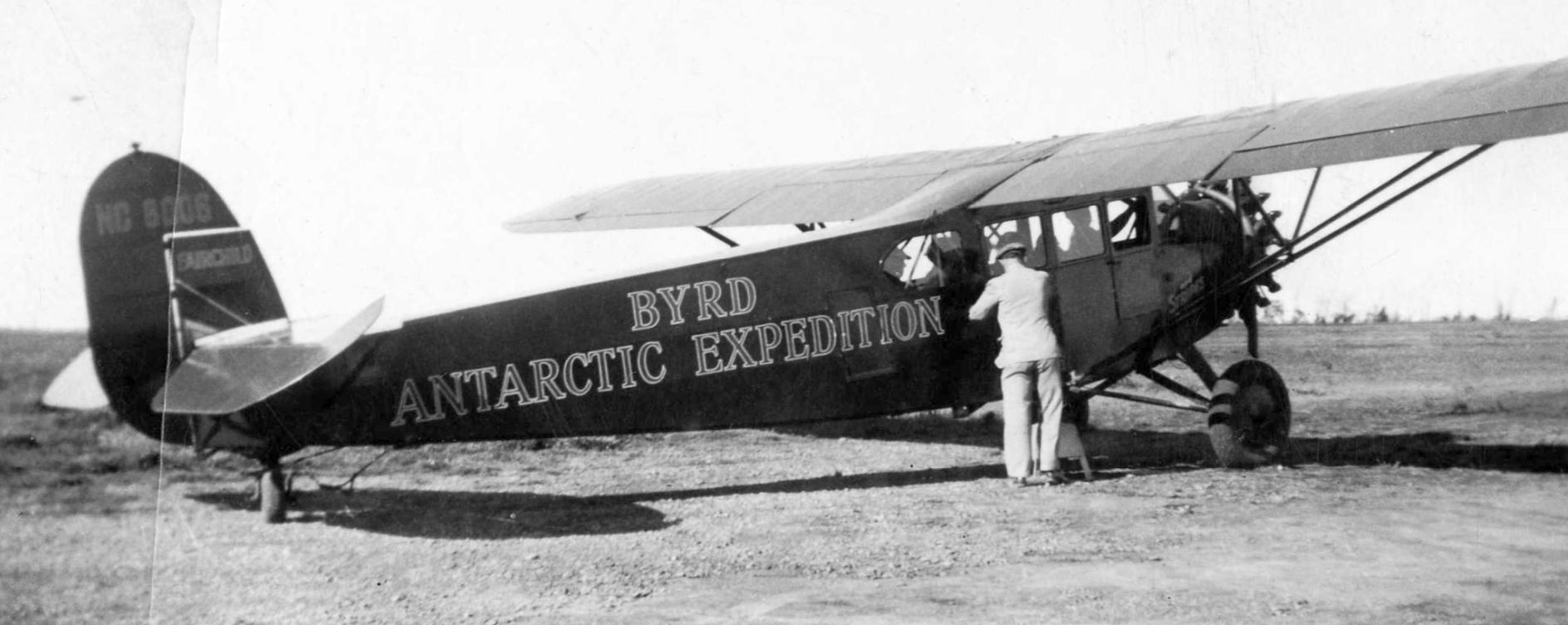
A 2/26/35 photo (courtesy of Petaluma Historical Library & Museum) of Fairchild FC-2W2, NC7006 serial # 140, as used by Admiral Richard Byrd on his 1929 & 1934 Antarctic explorations,
which had stopped at Petaluma Airport on a promotional tour.
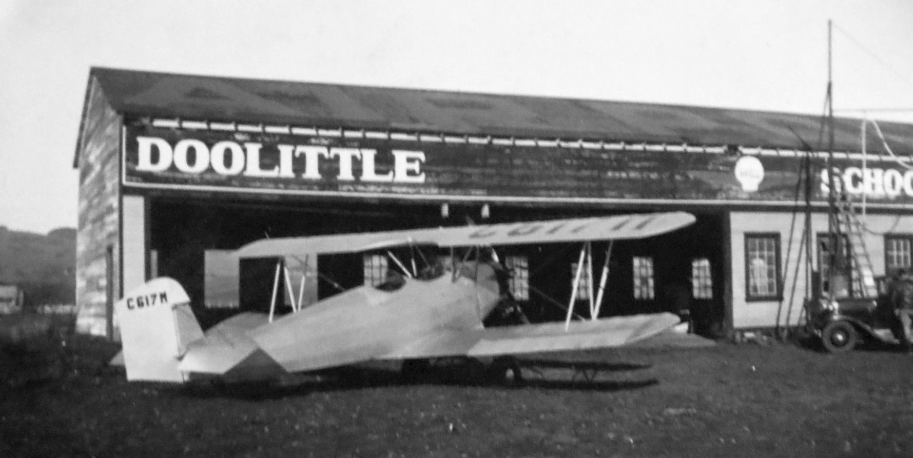
A 2/26/35 photo (courtesy of Petaluma Historical Library & Museum) of Harry Doolittle's Fleet 2 biplane NC617M construction #183, in front of the Doolittle School of Flight hangar at Petaluma Airport.
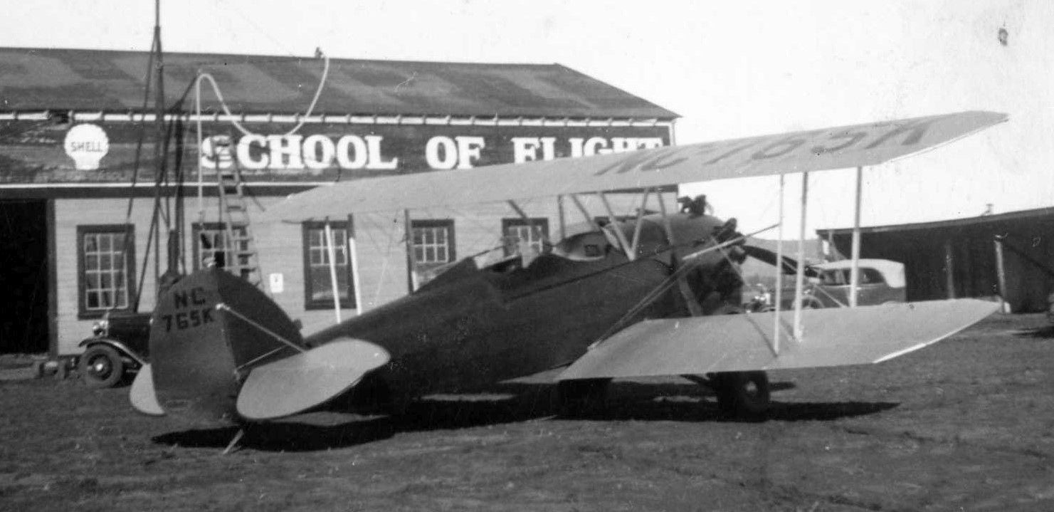
A 2/26/35 photo (courtesy of Petaluma Historical Library & Museum) of Waco biplane NC765K in front of the Doolittle School of Flight hangar at Petaluma Airport.
Terry Park reported, “The Great Depression took its toll on airport business, and in June 1935 Doolittle put Petaluma Airport up for sale.
In January 1936 the American Trust Bank foreclosed on the property because Doolittle defaulted on a loan payment.
The property probably was put back into agricultural use.”
No airfield in Petaluma was depicted on 1936/38/40/42/44/45 Sacramento Sectional Charts.
A 1952 aerial photo showed the site of Petaluma Doolittle Airport remained an open field,
with 1 building (possibly the former hangar) on the northeast side.
A 1968 aerial photo showed the site of Petaluma Doolittle Airport remained an open field,
but the possible former hangar had been removed at some point between 1952-68.
A 1982 aerial photo showed houses & streets had covered the site of Petaluma Doolittle Airport.
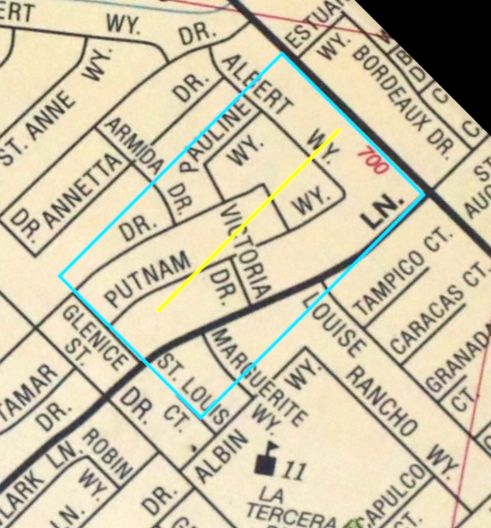
A 2023 street map annotated by Terry Park to show the property outline (blue) & runway location at the site of Petaluma Doolittle Airport.
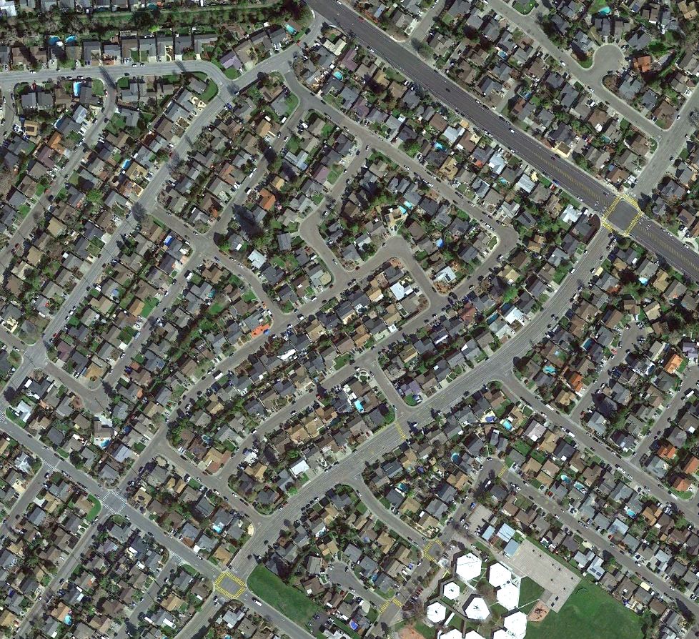
A 2021 aerial view showed no trace remaining of Petaluma Doolittle Airport.
____________________________________________________
Petaluma Airport, Petaluma, CA
38.262, -122.652 (North of San Francisco, CA)
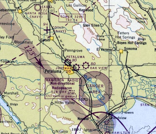
Petaluma Airport, as depicted on the September 1946 Sacramento Sectional Chart.
Carl Molesworth reported, “Petaluma had lacked a functioning airport for a decade when World War II ended in 1945.
With veterans flowing back into the community and a postwar economic boom sure to come, Petaluma was a prime location for the development of new aviation facilities.
One of the drivers of this effort was the Servicemens' Readjustment Act of 1944, commonly known as the G.I. Bill,
a law that provided a range of benefits for most of the returning World War II veterans (commonly referred to as G.I.s).
Benefits included low-cost mortgages, low-interest loans to start a business or farm, one year of unemployment compensation,
and dedicated payments of tuition & living expenses to attend high school, college, or vocational school.
Under the G.I. Bill, air-minded veterans would have the means not only to learn to fly, but also to establish flight schools that would make this possible.”
Carl continued, “The first two proposals to build a new Petaluma Airport were rolled out at a Chamber of Commerce board meeting less than two weeks after the signing of the armistice with Japan on 9/2/45.
Three local businessmen presented the more substantial of the two plans.
Paul Straub, a Petaluma contractor, and Ross Forry & Joe Feikert, owners of Forry & Feikert Garage, were the partners.
They were not yet pilots, but all three were eager to learn how to fly. 'I want to fly NOW', Forry said at the meeting.
To that end, Forry told the Chamber Board on September 11 that they had broken ground for a runway the previous evening
on farmland owned by Straub near the railroad crossing on North McDowell Road, and it would be ready for airplanes soon.
It would have been a simple matter for them to create the strip, since Straub not only owned the land but also had the construction machinery needed to clear space for the runway.
Construction continued into November, by which time the partners had obtained sanctioning from the Civil Aeronautics Administration for their airfield.
They also had formed a company, Petaluma Skyways, with veteran pilot J.A. 'Al' Norton as manager.
In December, Petaluma Skyways was approved as G.I. Bill flight school, and 22 students already had enrolled for flight training.
The company also obtained franchises to sell Luscombe & Taylorcraft aircraft.”
No airfield in Petaluma was depicted on the 1945 Sacramento Sectional Chart.
Carl Molesworth reported, “In April 1946, 17-year-old Joan Watson, a senior at Petaluma High School, became the first female student pilot to solo at Skyways.
Clifford Skoog, a former U.S. Army Air Force pilot, was her instructor.
Straub also soloed, Forry already was flying a plane he had purchased, and Feikert was still in training.
The co-owners started building a repair shop & restrooms, but hangar construction was being held up by a shortage of materials due to the postwar building boom.
Paul Straub bought out his partners Forry & Feikert, and in September 1946 he leased the airfield to Norton, who took over Petaluma Skyways as well.”
The earliest depiction which has been located of Petaluma Airport (on the north side of the town) was on the September 1946 Sacramento Sectional Chart.
It depicted Petaluma Airport as a commercial/municipal airport.
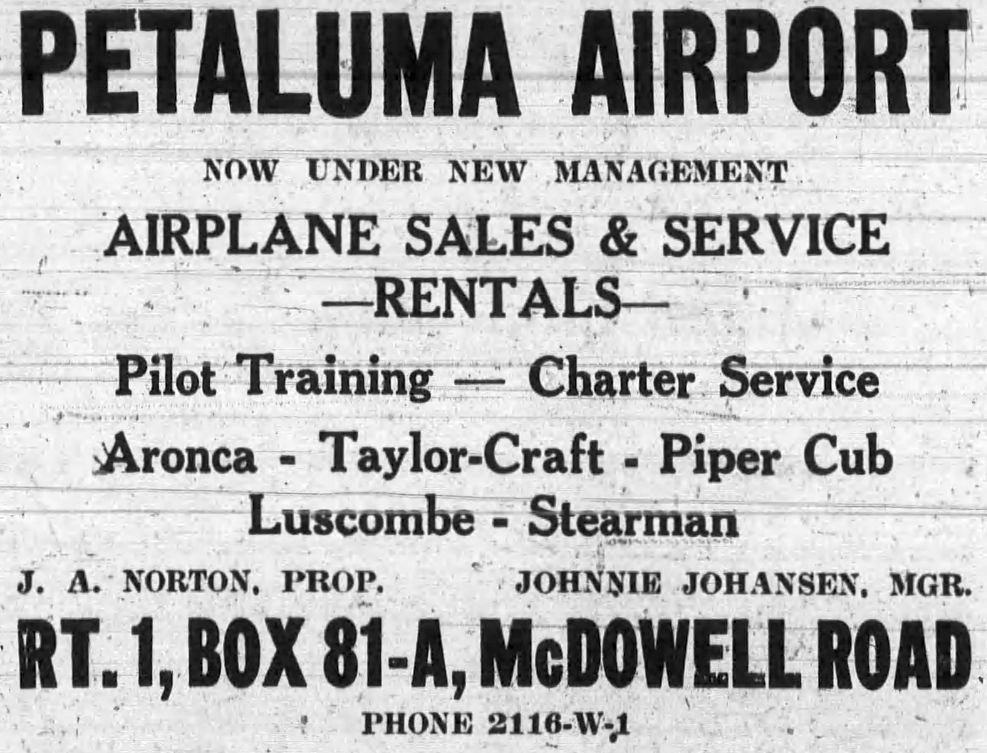
A 9/2/46 Argus Courier advertisement described Petaluma Airport as “under new management.”, with proprietor J.A. Norton, and manager Johnnie Johanson.
It was described as offering airplane sales, service and rentals; pilot training, charter service, for Aeronca, Taylorcraft, Piper Cub, Luscombe and Stearman aircraft.
Carl Molesworth reported, “Flight training under the G.I. Bill continued to be a popular program,
and in January 1949 Norton announced that 59 student pilots had signed up at Petaluma Skyways since his school obtained VA approval.
He added another service that July when Petaluma Skyways began advertising round-trip charter flights between Petaluma & Reno for 4 people at a cost of $98.
The first sign that flight training under the G.I. Bill might be endangered came in February 1948,
when U.S. Rep. Bernard Kearney introduced a bill in Congress to eliminate flight training as 'vocational' training from the G.I. Bill.
Norton & his cross-town competitor, George Justman of Justman Flying Service on the other end of McDowell,
joined an effort by the California Aviation Trades Association to defeat the bill.
Norton said he stood to lose $30,000 if the bill passed.
Not only would he have to sell 6 or 7 of his 10 planes at a loss, but he also would lay off 3 instructors, 2 mechanics and 1 office staffer.
The fight in Washington went on throughout the spring.
In June, Norton urged all flight trainees to telegraph their congressmen in opposition to the bill to kill G.I. Bill funding for flight training.
Apparently, that tactic was successful, as Norton received a letter from the CATA later that month thanking him for helping to maintain the status of VA flight training as 'vocational'.”
Carl continued, “November 1948 was notable, as G. Kephart of Petaluma became the 100th flight student to earn a private pilot’s certificate at Petaluma Skyways.
Norton also announced that his newest service was consignment sales of airplanes for private owners and that he now owned Napa Sky Ranch along with his Petaluma operation.
Petaluma Airport maintained a healthy level of activity, and a report in July 1949 contained the following details:
Bill Combs flew his new Beechcraft to Ohio; two Petaluma men flew a Cessna to Fort Bragg to collect abalone from the rocks;
postal worker Gene Bell chartered a flight to Marysville that took 45 minutes, while a bus would have taken 4-5 hours.
Local businessman Ralph Fitzpatrick was the newest flight student., and several pilots applied for flight instructor courses under the G.I. Bill.”
Carl continued, “A renewed effort to remove flight training from the G.I. Bill succeeded, and in April 1950 Norton issued a reminder to would-be student pilots that time was running out to use their benefits.
Perhaps connected to this, a group of soldiers stationed at Two Rock formed a flying club & bought a Piper Cub, which they based at Petaluma Airport.
Lewis Eckman & Gil Avila serviced the plane. Several members already had their licenses, and the rest planned to use the Cub for flying lessons.
A report in June 1950 stated Petaluma Skyways had taught more than 300 students to fly since the end of the war.
Twenty aircraft were based at the field, and a helicopter often used it, too. A crop duster, Art Newman of Kelseyville, used the field during mosquito spraying season.”
Carl continued, “With Cold War tensions building, in April 1951 Petaluma Airport and Justman’s Sky Ranch were designated as Control Airports for smaller fields
(such as the Waldo Rohnert strip at Cotati) by the California State Aeronautics Commission as part of the CAA’s civil defense plan.
But the end was near for Petaluma Skyways & Petaluma Airport.
On 4/29/51, Al Norton & a passenger, Leonard “Penn” Donovan, suffered critical injuries in an airplane accident at Petaluma Airport.
After emergency treatment in Petaluma, Norton was sent by ambulance to Franklin Hospital in San Francisco on May 2 for further treatment.
He was released from the hospital & returned to the airport, where he & his wife had a residence, on July 26 with a heavy cast on one leg.”
Carl continued, “Further tragedy struck in the early hours of 4/10/52, when Norton awoke at 5am to see the large hangar aflame.
The Penngrove Fire Department responded quickly, but the crew was too late to save the hangar, the 3 airplanes stored inside, or Norton’s car.
Paul Straub, who leased the airport & land to Norton & owned the uninsured hangar, estimated the loss at $20,000.
The cause of the fire was not determined.
For all intents & purposes, the fire was the end of Petaluma Skyways.
There were no further mentions of Norton or Petaluma Skyways in the press.”
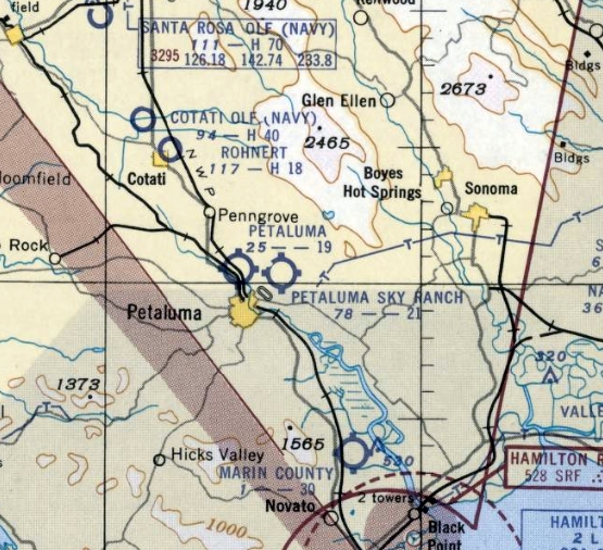
The last aeronautical chart depiction which has been located of Petaluma Airport (on the north side of the town) was on the 1952 Sacramento Sectional Chart.
It depicted Petaluma Airport as having a mere 1,900' unpaved runway.
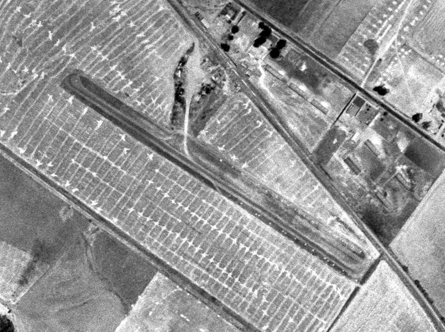
The only photo which has been located of Petaluma Airport (on the north side of the town) was a 1952 aerial view (courtesy of Carl Molesworth).
It depicted Petaluma Airport as having a single unpaved northwest/southeast runway, with 1 light single-engine plane parked on the north side.
Petaluma Airport was evidently closed at some point between 1952-53,
as it was no longer depicted on the 1953 Sacramento Sectional Chart.
Carl Molesworth reported, “There was no listing for Petaluma Skyways or Al Norton in the 1953 Petaluma telephone directory. By 1956 the land had reverted to farming.”
A 1968 aerial photo showed the site of Petaluma Airport remained an open field, but with no aircraft or buildings.
A 1982 aerial photo showed the Petaluma Airport site remained an open field.
A 1993 aerial photo showed a road & a large building had been built over the center of the the Petaluma Airport site.
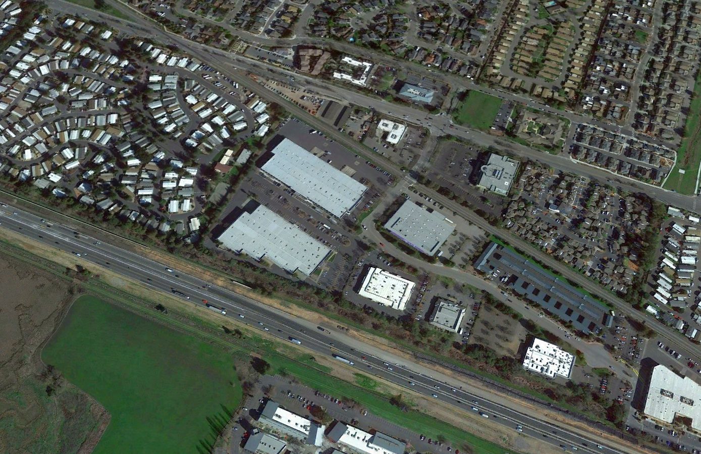
A 2021 aerial view looking northeast showed no trace remaining of Petaluma Airport.

A 2023 street map annotated by Terry Park to show the property outline (red) & runway location at the site of Petaluma Airport.
Carl Molesworth reported in 2023, “These days, several office buildings & a storage facility on Southpoint Boulevard stand alongside the former site of the Petaluma Airport runway.”
____________________________________________________
38.239, -122.611 (North of San Francisco, CA)
Justman Airport, as depicted on the September 1946 Sacramento Sectional Chart.
No airfield in Petaluma was depicted on the 1945 Sacramento Sectional Chart.
Carl Molesworth reported, “The man who made the greatest contribution to aviation in the Petaluma area during the postwar period was George Justman.
Justman was working for United Airlines when he took a military leave of absence to become an Army pilot during World War II.
When the war ended in 1945, he decided to return to his career in civilian aviation & settled on Petaluma as the place to do it.
At the same time, he would be able to continue his military flying with the Air Force Reserve at nearby Hamilton Field.
Like the partners at rival Petaluma Skyways, Justman saw opportunity in the new G.I. Bill, which provided veterans with a variety of benefits that included paying for flight training.
He acquired 22 acres from the Perry Ranch on South McDowell, cleared a grass landing strip running perpendicular to the road & began signing up students for his flight school.
He proved an able promoter of civil aviation in general & his business in particular, writing articles for the newspaper about his students’ successes,
organizing a flying club called the 'Throttle Benders' & partnering with the Petaluma Lodge #475 Loyal Order of the Moose to form an Air Scouts troop.
He added a hangar at Justman Field & purchased several Aeronca Champion light aircraft for trainers.”
The earliest depiction which has been located of Justman Airport was on the September 1946 Sacramento Sectional Chart.
It depicted Justman as a commercial/municipal airport.
Carl Molesworth reported, “Justman Flying Service thrived for 3 years, but by 1948 it was becoming clear that residential development around his airfield would soon make the site untenable.”
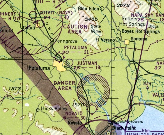
The last aeronautical chart depiction which has been located of Justman Airport was on the February 1949 Sacramento Sectional Chart.
It depicted Justman Airport as having a mere 1,800' unpaved runway.
Carl Molesworth reported, “Justman’s new Sky Ranch Airport opened on 7/10/49”, at which point Justman Airport was presumably closed.
Justman Airport was no longer depicted on the September 1949 Sacramento Sectional Chart.
A 1952 aerial view showed the site of Justman Airport remained an open field, with 2 T-hangars along the northeast side.
A 1968 aerial photo showed the site of Justman Airport remained an open field, but the 2 T-hangars had been removed at some point between 1952-68.
A 1982 aerial photo showed streets & houses had covered the Justman Airport site.
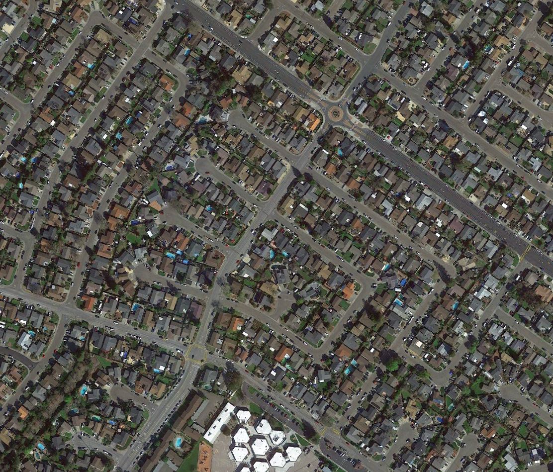
A 2021 aerial view showed no trace remaining of Justman Airport.
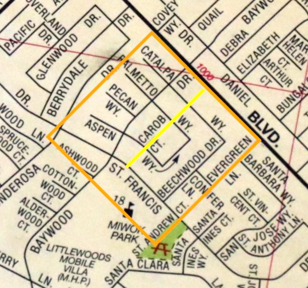
A 2023 street map annotated by Terry Park to show the property outline (orange) & runway location at the site of Justman Airport.
____________________________________________________
Oak View Airport, Petaluma, CA
38.252, -122.58 (North of San Francisco, CA)
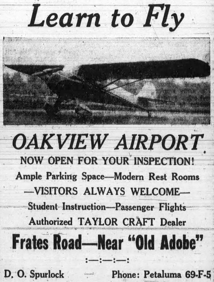
A 2/9/46 Argus Courier advertisement described Oak View Airport as offering student instruction, passenger flights, and a Taylorcraft dealership.
No airport in Petaluma was yet depicted on the February 1946 Sacramento Sectional Chart.
The earliest reference which has been located to Oak View Airport was a 2/9/46 Argus Courier advertisement
It described Oak View Airport as offering student instruction, passenger flights, and a Taylorcraft dealership, and listed the manager as as D.O. Spurlock.
The earliest depiction which has been located of Oak View Airport was on the September 1946 Sacramento Sectional Chart.
It depicted Oak View as a commercial/municipal airport.
According to Carl Molesworth, a 4/18/46 Argus Courier story listed D.O. Spurlock as Oak View Airport's field manager & CAA inspector,
and said that 5 students had received their pilot certificates.
The last advertisement which has been located for Oak View Airport was a May 1946 advertisement (according to Carl Molesworth).
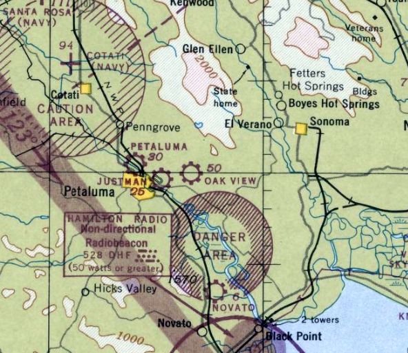
The last aeronautical chart depiction which has been located of Oak View Airport was on the February 1947 Sacramento Sectional Chart.
It depicted Oak View Airport as a commercial/municipal airport.
Oak View Airport apparently closed after only a year, as it was no longer depicted on the February 1948 Sacramento Sectional Chart.
A 1952 aerial view showed open fields near the Oak View Airport site, with no specific recognizable trace of an airfield.
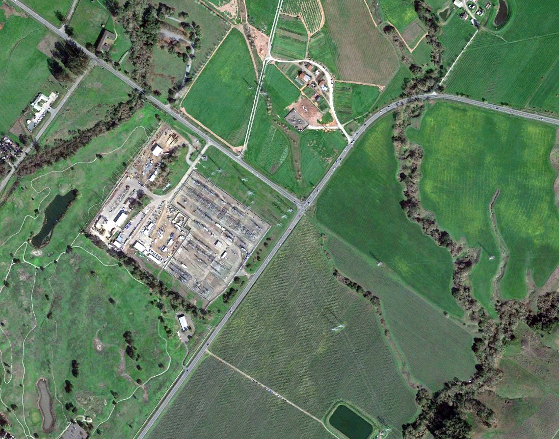
A 2021 aerial view showed no trace remaining of Oak View Airport.
____________________________________________________
Petaluma Sky Ranch Airport, Petaluma, CA
38.259, -122.614 (North of San Francisco, CA)
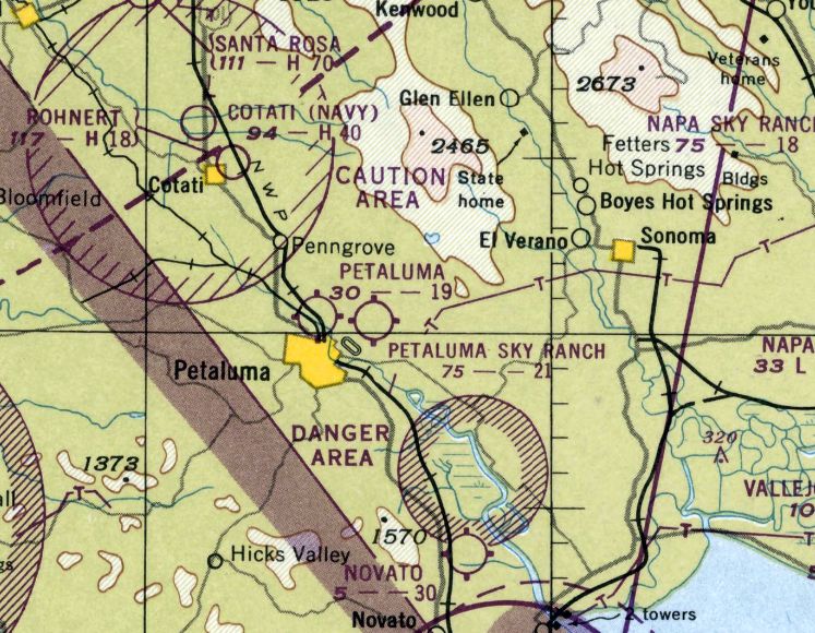
Petaluma Sky Ranch Airport, as depicted on the September 1949 Sacramento Sectional Chart.
Petaluma Sky Ranch Airport was not yet depicted on the February 1949 Sacramento Sectional Chart.
Carl Molesworth reported, “The man who made the greatest contribution to aviation in the Petaluma area during the postwar period was George Justman, founder & longtime operator of the Petaluma Sky Ranch.”
From 1945-48, Justman operated Justman Airport, until residential development made the Justman Airport location untenable.
Carl Molesworth reported, “In October 1948, Justman received a use permit from Sonoma County to build a new airport on property he purchased from the Pronini Brothers on East Washington Street.
The permit allowed for construction of a Class 1 airstrip for light aircraft, along with four hangars to house 12 aircraft, living quarters, offices & the Justman Flying Service flight school.
Justman’s new Sky Ranch Airport opened on 7/10/49, with an open house that featured flight demonstrations, parachute jumps & flyovers by military aircraft.
Sky Ranch Airport quickly became a popular destination for pilots from the Bay Area and beyond, and in June 1950 Justman recorded more than 70 takeoffs and landings by visiting aircraft.
His flight school also was thriving, even though the GI Bill funding for flight training was soon to expire.
In addition to primary flight training, Justman Flying Service also offered courses for commercial flying & flight instruction.”
The earliest depiction which has been located of Petaluma Sky Ranch Airport was on the September 1949 Sacramento Sectional Chart.
It depicted Petaluma Sky Ranch Airport as having a 2,100' unpaved runway.
The earliest photo which has been located of Petaluma Sky Ranch Airport was a 1952 aerial view.
It depicted Petaluma Sky Ranch Airport as having a single northwest/southeast unpaved runway, with several small buildings & 5 light single-engine aircraft on the northeast side.
Carl Molesworth reported, “Presumably, Petaluma Sky Ranch benefited from a reduction in competition with the demise of the Petaluma Skyways operation on North McDowell in the spring of 1952.
International affairs also began to have an impact on Justman’s operation with the increased tensions of the Cold War & the outbreak of hostilities on the Korean Peninsula.
In April 1951, Petaluma Sky Ranch was designated a Control Airport by the California State Aeronautics Commission under its civil defense plan.
Pilots departing from the Waldo Rohnert Airfield at Cotati for flights higher than 4,000' were required to file flight plans at Sky Ranch.
By 1953, the GI Bill funding for flight training was restored as a benefit for American servicemen & women returning from Korea, and signups at Justman Flying Service picked up.
In addition, Justman joined the newly formed Private Airport Owners Association, an organization tasked with advocating for the interests of privately-owned airports such as Petaluma Sky Ranch.
Wear & tear on the busy little airport was inevitable, and in 1954 the Sky Ranch runway & turnaround strips were resurfaced, and a sidewalk was installed at the ready room.”

The earliest topo map depiction which has been located of Petaluma Sky Ranch Airport was on the 1954 USGS topo map.
It depicted Petaluma Sky Ranch Airport as having a single northwest/southeast paved runway, with a row of 8 hangars along the northeast side.
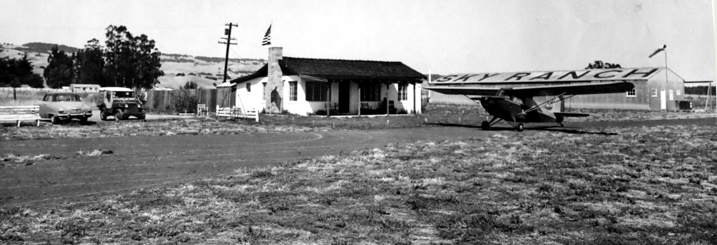
The earliest photo which is available of Petaluma Sky Ranch Airport was an early 1950s photo of an Aeronca Champion sits in front of the operations building & residence (courtesy of the Petaluma Historical Library & Museum).
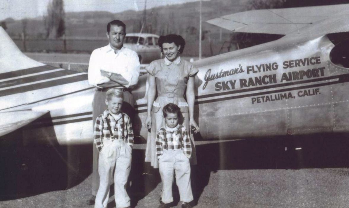
A 1950s photo of George & Violet Justman & their 2 sons in front of a Justman Flying Service Cessna at Petaluma Sky Ranch Airport (courtesy of the Petaluma Historical Library & Museum).
Carl Molesworth reported, “Justman’s Flying Service used the Cessna for flight training, charters and fire-spotting.”
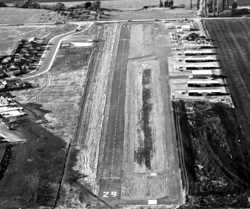
A mid-1950s aerial view looking west (courtesy of the Petaluma Historical Library & Museum) showed Petaluma Sky Ranch Airport to have an asphalt Runway 11/29,
with a dozen small hangars & over 20 light aircraft.
Carl Molesworth observed, “Housing was beginning to encroach on the west side of Sky Ranch Airport.”
Carl Molesworth reported, “By 1954, Sky Ranch promoted itself as Northern California’s largest private airport.”
Carl Molesworth reported, “Interest among certain Petaluma leaders for a city-owned airport dated all the way back to the end of World War II, and began picking up again as the 1960s touched down.
On 4/29/61, Justman published a long column in the local newspaper questioning the need for a publicly-owned airport in Petaluma.
He mentioned that many city leaders feared that zoning around the airport, allowing housing developments, would eventually make the airport untenable.
He went on to report that of the 26-30 airplanes based at his airport, only 3 belonged to Petaluma residents.
But by this time, George Justman’s 14-year marriage to the former Violet Patocci of Petaluma was coming to an end.
He soon left Petaluma & leased out the airport & business to H.E. York & Sons, who later turned over the lease to three partners, Howland Smith, Thomas Cole and William Connors, with Harold French serving as airport manager in 1965.”
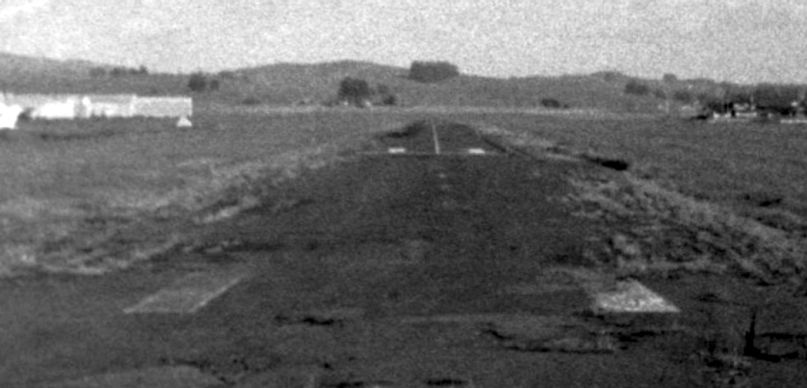
A mid-1960s aerial view (courtesy of the Sonoma County Library) from final approach to Petaluma Sky Ranch Airport's Runway 11, with hangars visible to the left.
Carl Molesworth reported, “Connors wrote an article for the Argus-Leader in 1969 extolling the virtues of the airport,
including its 2,200' paved & lighted runway, its FAA-approved flight school & a variety of aviation services including aircraft maintenance, rentals, charters & air taxis.
He quoted FAA statistics showing 22,000 takeoffs & landings in 1967.
In 1970, Violet Tufts, Justman’s ex-wife, sold the airport property but retained the flight school & was operating it herself.
She reported the following year that 60 planes were based at the field, and Adobe Aviation had 30 students & 12 employees. Seven businesses were using the airport.
The recently formed Petaluma Pilots Association had 73 members.”
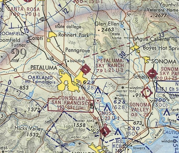
The last aeronautical chart depiction which has been located of Petaluma Sky Ranch Airport was on the November 1971 San Francisco Sectional Chart.
It depicted Petaluma Sky Ranch Airport as having a 2,100' paved runway.
Carl Molesworth reported, “Mike Jose, a well-known one-armed pilot, managed the airport from 1972-77.
In 1973, John Runyon took over the flight school, followed in 1975 by Jim Higgins, who also was doing charters & rentals.”
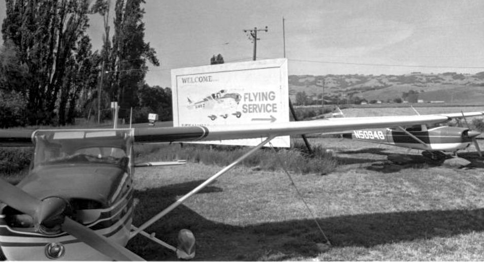
A 1973 photo (courtesy of the Sonoma County Library) of 2 Cessnas in front of the Petaluma Sky Ranch Airport sign on East Washington Street.
Carl Molesworth observed, “The Justman name had been painted out from the Petaluma Sky Ranch sign.”
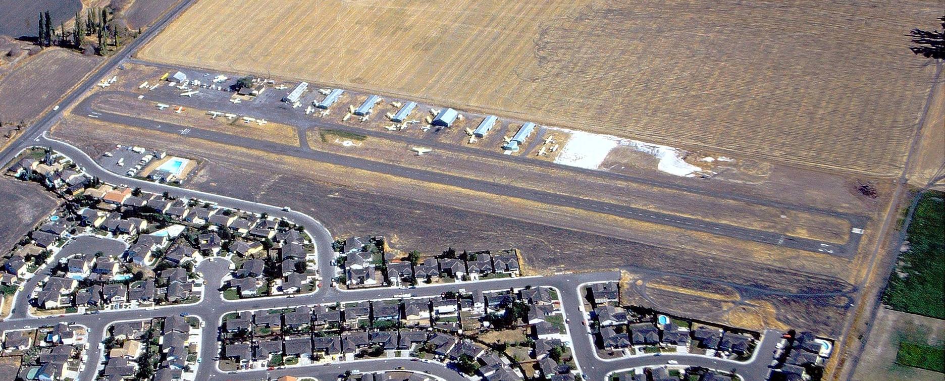
A 1976 aerial view by George Christenson (courtesy of the Petaluma Historical Library & Museum) looking north at Petaluma Sky Ranch Airport.
Carl Molesworth observed, “This shows the Petaluma Sky Ranch at its peak, with its 2,200' paved & lighted runway, 7 open-sided hangars & nearly 40 aircraft parked on the facility.
Beyond to the east is the Schlake Ranch, where the current Petaluma Municipal Airport would be built in 1984-85.”
Carl Molesworth reported, “Despite the activity at the airport, its days were numbered as residential neighborhoods continued to encroach.
In September 1977, Petaluma Vice Mayor Bill Perry, a licensed pilot, had convened a committee to discuss plans for a municipal airport.
This time, the city meant business. Plans were made for the city to acquire Petaluma Sky Ranch & property east of to it for a new, larger airport with sufficient buffers from nearby residential neighborhoods.”
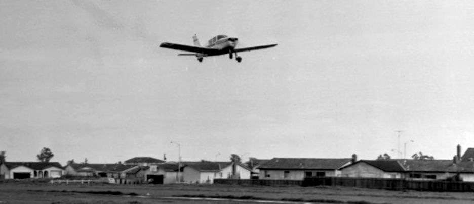
A 1978 photo of a Piper landing at Petaluma Sky Ranch Airport (courtesy of the Sonoma County Library), showed how close the airport’s runway was to neighboring houses.
Carl Molesworth reported, “Mike Jose owned & operated Petaluma Sky Ranch from 1980-82.”
The last photo which has been located of Petaluma Sky Ranch Airport was a 1982 aerial view.
It depicted a very well-used airport, with dozens of light planes parked in between the hangars along the northeast side.
Carl Molesworth reported, “Phil & Sharon Perrin bought the airport in 1983 & stayed for one year before selling it to the City of Petaluma.
The Sky Ranch was dismantled, and Petaluma Municipal Airport opened in 1985.”
Petaluma Sky Ranch Airport was no longer depicted on the 1993 San Francisco Sectional Chart, which instead depicted the replacement Petaluma Municipal Airport.
A 1993 aerial view showed the adjacent Petaluma Municipal Airport had been constructed.
A road had been built over the alignment of the former Petaluma Sky Ranch Airport, and all of the hangars had been removed.
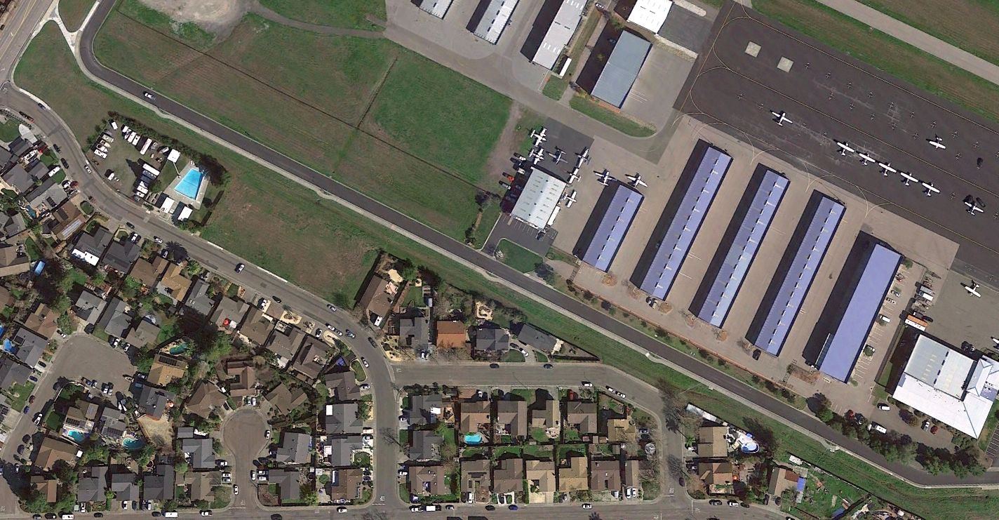
A 2021 aerial view looking north showed Sky Ranch Drive overlaying the location of the former Petaluma Sky Ranch Airport runway, with the replacement Petaluma Municipal Airport directly adjacent to the northeast.
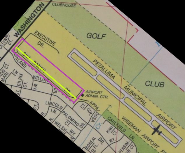
A 2023 street map annotated by Terry Park to show the property outline (purple) & runway location (yellow) of the former Petaluma Sky Ranch Airport,
noting the present-day Petaluma Municipal Airport directly adjacent.
As of 2023, the site of Petaluma Sky Ranch Airport is memorialized by the name of Sky Ranch Drive which overlays the former runway location.
____________________________________________________
Cotati Naval Outer Landing Field, Cotati, CA
38.35, -122.72 (Northwest of San Francisco, CA)
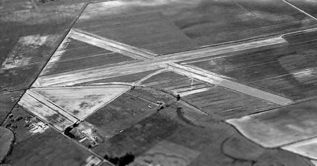
A 1942 aerial photograph looking northeast at the Cotati airfield (National Archives photo, courtesy of Dan Sebby), taken prior to the construction of any buildings or fuel tanks.
Both runways had been constructed, but the concrete apron had not yet been built.
According to the book "Two Hours By Crow" by Howard & Judith Campbell (courtesy of Wings of History),
“In 1941, the 12th Naval District was tasked with setting up a aviation training facility somewhere near their main base on Alameda Island.
They purchased 245 acres from the Rohnert Seed Company in Cotati.
By November, a month before the Pearl Harbor attack on December 11th caused the U.S. to go to war, ground had been broken for the 2 crossed runways, and a combined barracks & control tower building.
Then came the surprise! The winter rains in this area cause the Russian River, some 14 miles to the north, to swell & back water up through the Laguna de Santa Rosa Creek that drains the Air Station land.
After struggling through the spring of 1942, construction continued; but by the spring of 1943, the Navy realized the limitations of the site & moved their Auxiliary Air Station north to Santa Rosa off State Route.
This now became an 'Outlying Field'. With the downgrading of its status, only minimum facilities were built & the site was used for carrier takeoff & landing practice.”
"Two Hours By Crow" continued, “White staple-shaped marks were painted on the asphalt runways to define the flight decks of the trainees' future nautical bases.
These marks were 85' wide with 230' long legs; the closed ends of a set were 2,200' apart on Runway 7/25; and 2,550' apart on Runway 13/31.
These simulated ship lengths were much longer than the available flight decks thus compensating for the lack of forward speed of the ground.”
The earliest photo which has been located of the Cotati airfield was a 1942 aerial photograph looking northeast (courtesy of Dan Sebby).
The photograph showed the 2 paved runways as nearly complete, but the field was still lacking its concrete apron & any buildings.
The Cotati airfield was not yet depicted on the September 1942 Sacramento Sectional Chart.
An additional 75 acres were acquired on 6/16/43 by Declaration of Taking between the Federal Government & the Cotati & Rohnert Companies,
bringing the base's total acreage to 217 acres.
NAAS OLF Cotati became operational in 1943.
Cotati was primarily used for touch & go exercises for aircraft from Alameda & Santa Rosa Naval Air Stations.
A 2-story control tower was located on the southeast side of the field.
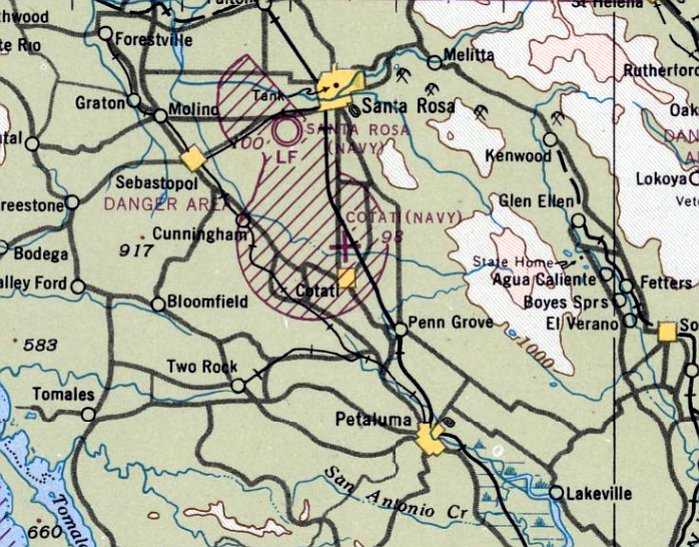
The earliest aeronautical chart depiction which has been located of NOLF Cotati was on the August 1943 Sacramento Sectional Chart.
It depicted “Cotati (Navy)” as an auxiliary airfield.
According to a 1944 General Layout Map of the Cotati Air Facility, the field contained runways, a control tower,
fire & crash truck garage, gasoline & oil storage, a small arms magazine, and a machine gun range.
The 1944 US Army/Navy Directory of Airfields (courtesy of Ken Mercer) described "Cotati OLF, Navy" as having a 3,900' runway.
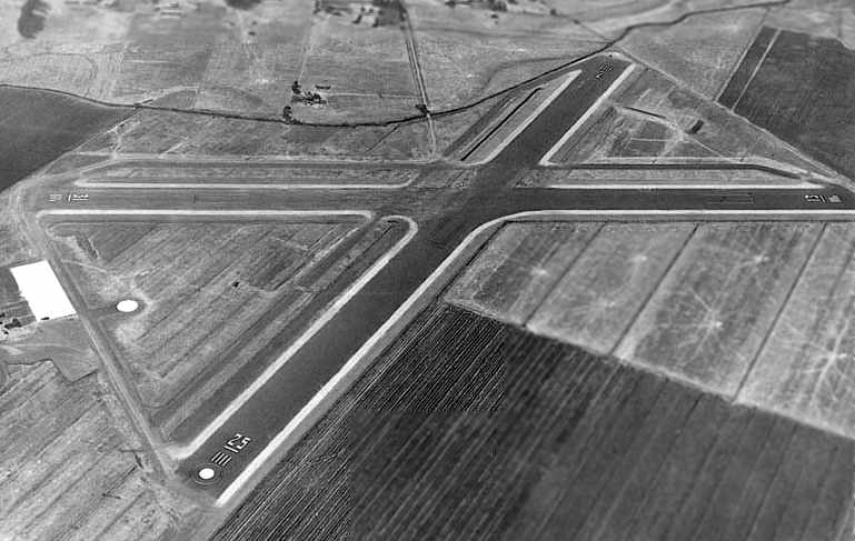
A 1944 aerial photograph looking southwest at the Cotati airfield, in its complete WW2-era configuration (National Archives photo, courtesy of Dan Sebby).
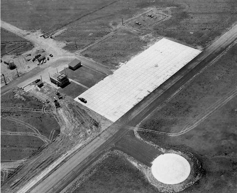
A 1944 aerial photograph looking south at Cotati's ramp & control tower (National Archives photo, courtesy of Dan Sebby).
"Two Hours By Crow" continued, “Training progressed from the first Grumman F4F Wildcat, Douglas SBD Dauntless, and Grumman TBF Avenger;
to the much later Grumman F8F Bearcat, Curtiss SB2C Helldiver, and a few Chance- Vought F4U Corsairs.”
The 1945 AAF Airfield Directory (courtesy of Scott Murdock) described “Santa Rosa Field Auxiliary (Cotati Outlying Field)”
as a 200 acre irregularly-shaped property containing 2 asphalt runways, measuring 4,000' ENE/WSW & 3,800' northwest/southeast.
The field was not said to have any hangars, to be owned by the U.S. Government, and operated by the Navy.
Cotati was described as “Inactive”.
As of 1945, Cotati was one of 2 outlying fields assigned to NAAS Santa Rosa (according to John Voss).
In 1945 there were several sub-base runway failures due to flood-related moisture.
Documents found in the National Archives indicated that repairs were requested & approved,
but due to the extent of failures these costly repairs were never completed.
After the military ceased operations at Cotati in 1945 the airfield remained idle for several years.
"Two Hours By Crow" continued, “The field was closed in 1946.”

"Cotati (Navy)", as depicted on the 1946 Sectional Chart (courtesy of Dann Shively).
On the 1948 Sacramento Sectional Chart (courtesy of John Voss),
Cotati was still depicted as an active Navy Field, with the largest runway being listed as a 4,000' paved strip.
It was still labeled "Cotati (Navy)" on the 1949 Sacramento Sectional Chart (according to Chris Kennedy).
A 1949 Memorandum from the Commander, Naval Air Bases, 11th & 12th Naval District states that Cotati was in inactive status.
The arable lands were under a lease for agricultural purposes,
and the Sonoma County Peace Officers’ Association used the rifle range under a permit.
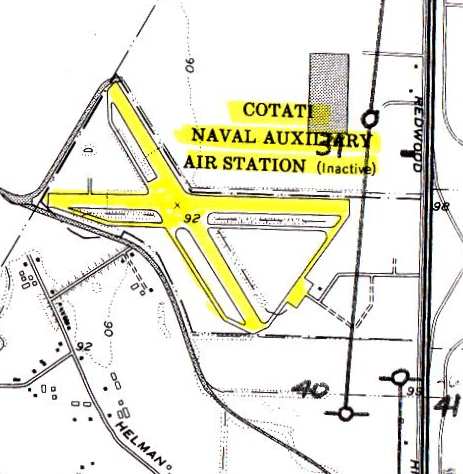
The 1950 USGS topo map (courtesy of John Voss) depicted "Cotati Naval Auxiliary Air Station (Inactive)" as having 2 paved 4,000' runways,
one oriented east/west, and the other northwest/southeast, each with parallel taxiways.
A small paved ramp area was on the southeast side of the airfield.
There did not appear to be any hangars depicted on the map, just one very small building along the side of the ramp.
"Two Hours By Crow" continued, “The field was declared surplus in 1950.”
Drag racing historian Bret Kepner said that drag racing occurred on the former Cotati runways as early as 1952, and that the runways were "bumpy as hell".
He confirmed that Cotati was one of the true "originals" in drag racing.
The 1952 San Francisco Local Aeronautical Chart (courtesy of Jonathan Westerling)
depicted “Cotati OLF (Navy)” as having 2 paved runways, with the longest being 4,000'.
In 1953, the Cotati airfield property was suggested as a location for Sonoma State College, but this was not pursued.
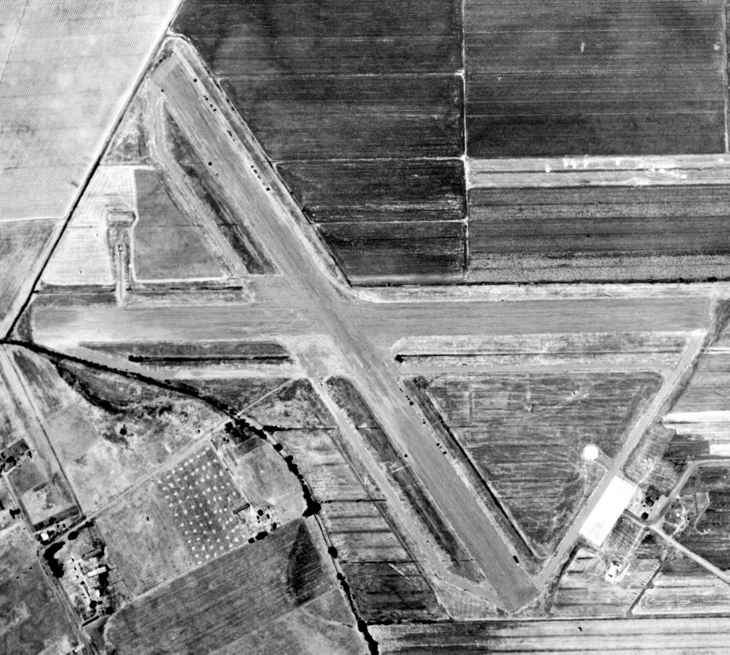
A 10/13/52 aerial photo (from the UCSB Photo Library) depicted the Cotati airfield after being abandoned, but still intact.
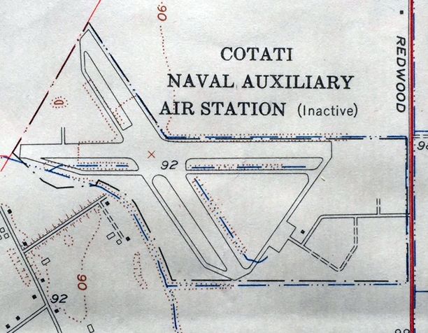
The 1954 USGS topo map (courtesy of Kevin Walsh) labeled the airfield as "Cotati Naval Auxiliary Air Station (Inactive)".
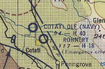
"Cotati OLF (Navy)" was still depicted on the March 1954 USAF Sacramento Sectional Chart (courtesy of Chris Kennedy),
but the Aerodromes table listed the field's status as "Unattended".
On 2/16/56, Naval Outer Landing Field, Cotati was declared excess by the military.
At some point in 1956, a total of 95 acres were leased to M.J. Azevedo for agricultural purposes.
Cotati NOLF was no longer depicted at all on the 1957 Sacramento Sectional Chart (according to Chris Kennedy).
In 1957, the California Research Corporation requested a license covering
the use of the Cotati runways for road testing purposes.
A lease for 35 acres was approved for a period of one year from 1957-58.
Another lease permitted the City of Santa Rosa to use the former Navy runways for drag racing.
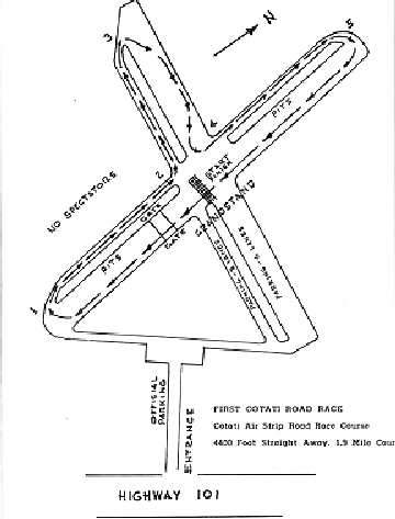
A diagram showing the race layout over the abandoned Cotati runways from a 1957 program of the "First Cotati Road Race" (courtesy of Dann Shively).
According to Chad Murray, a longtime resident remembered that "When the strip was closed down,
the neighbor at the end of [Airport Road] turned the old facility into a drag strip & would collect $ for entrance."
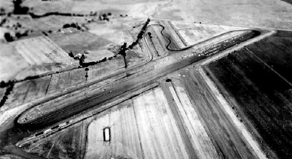
A 1957 aerial photo depicting the former Cotati runways being reused as a racetrack (courtesy of Gary Horstkorta, via Dann Shively).
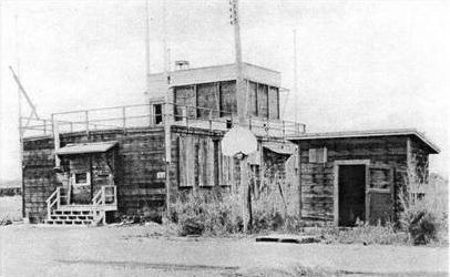
A 1958 photograph looking southwest at Cotati's abandoned control tower, from a 1958 GSA property appraisal (courtesy of Dan Sebby).
The report described “the condition of this building is extremely poor as the sashes & doors have been destroyed,
the ceilings disintegrated & very little of value remaining other than salvage.”
On 7/21/58, the Federal Government conveyed the entire 217 acres to Michael Callan by deed.
Chuck Ross recalled, "I used to go to drag races there in about 1959 or so.
The quarter-mile strip ran toward the northwest & the pits were down the other runway to the west.
A driver named Jay Cheatham was killed there about that time."
Apparently, the Cotati airfield saw at least some unofficial reuse as a civil airfield.
Hugh Codding (who owned the Cotati property in 1999) recalled that he used to fly his small plane into the former landing field in the 1950s
while it was being utilized for drag racing & road testing.
The former Cotati airfield was no longer depicted at all on the 1961 Sectional Chart (courtesy of Dann Shively).
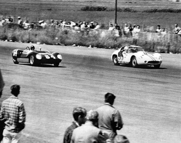
A 1963 photo of a Lotus & Maserati racing on the former Cotati runways.
"Two Hours By Crow" continued, “The 'Street Angels' held drag races there and Sports Car Club of America, the Formula Racing Association, and the Racing Drivers Club all used the runways as a race track in the 1960s.”
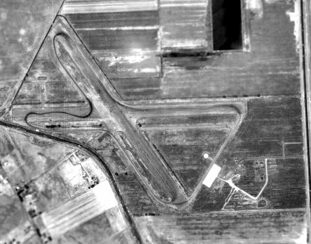
The last aerial photograph which has been located which depicts the Cotati airfield before it was largely redeveloped
was this 1965 USDA aerial photograph of the former Cotati airfield (courtesy of Dan Sebby).
The photograph showed obvious signs of tire tracks on the runways during the site's reuse as a racetrack;
racing facilities were present along the northwest/southeast runway.
The tank location looked undisturbed; structures were still in place over the tanks.
No other buildings from the former NAAS OLF Cotati facility were present except for the tanks.
In the spring of 1968, developer Hugh Codding offered to sell the 80 acre site to the County for development as the South County Airport,
but the County Board of Supervisors would not even consider the proposal.
In 1971, Redwood Drive was relocated on the eastern border of the former airfield & off/on ramps were constructed on the former field.
Rohnert Park Expressway also was built between 1971-73.
A 1977 aerial photograph obtained from the City of Rohnert Park showed that the northwest corner of the property had been covered by the Rancho Verde Mobile Home Park,
and retail construction had taken place over the eastern edge of the site as well.
However, the eastern half of both runways still remained intact.
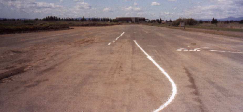
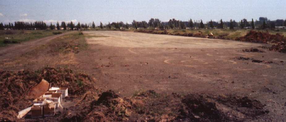
Two 1985 photos John Voss of the former runways at NOLF Cotati, before they were redeveloped.
In 1986, Codding Enterprises began redevelopment of another portion of the former airfield for retail shopping centers,
which eventually included a K-Mart & Target.
A 1987 aerial photograph obtained from the City of Rohnert Park showed that further redevelopment had taken place,
with only the outline of the southeastern end of the former northwest/southeast runway still somewhat recognizable.
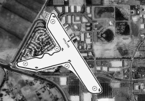
The layout of the racetrack which used the former Cotati runways, superimposed over the 1993 USGS aerial photo of the site (courtesy of Gary Horstkorta, via Dann Shively).
The photograph otherwise showed that all traces of the former airfield had been removed by 1993.
As of 1999, the property was still owned by Codding Enterprises, a property management company.
The property consisted of Ranch Verde Mobile Home Park to the north, theater, bank, restaurants,
office buildings & retail stores to the south & an apartment complex to the east.
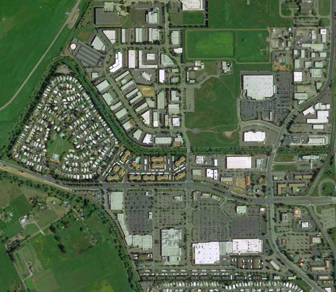
A 2013 aerial photo showed no trace remaining of the Cotati airfield.
The site of Cotati NOLF is located at the present-day intersection of Rohnhert Park Expressway & Labath Avenue.
The former airport access road is still there, appropriately named "Airport Road".
Thanks to Chad Murray & David Freeman for pointing out the Cotati airfield.
See also:
A 1999 Army Corps of Engineers report about Cotati
http://www.sonic.net/~kargo/rphistory.htm
____________________________________________________
____________________________________________________
This site covers airfields in all 50 states.