Abandoned & Little-Known Airfields:
Ohio: Cincinnati area
© 2002, © 2026 by Paul Freeman. Revised 10/19/26.
This site covers airfields in all 50 states: Click here for the site's main menu.
____________________________________________________
Please consider a financial contribution to support the continued growth & operation of this site.
Cincinnati Incorporated Airport / Hugh Watson Field / Blue Ash Airport (revised 10/19/26)
Cincinnati Western & Southern Heliport (added 12/14/21) - Grisard Field / Watson Airport / Parks Watson Landing Field / Blue Ash Airport (revised 3/11/23)
Lakewood Airpark (revised 12/9/17) - Wright's Farm Airfield (revised 11/26/23)
____________________________________________________
Cincinnati Western & Southern Heliport (O21), Cincinnati, OH
39.1, -84.507 (Downtown Cincinnati, OH)
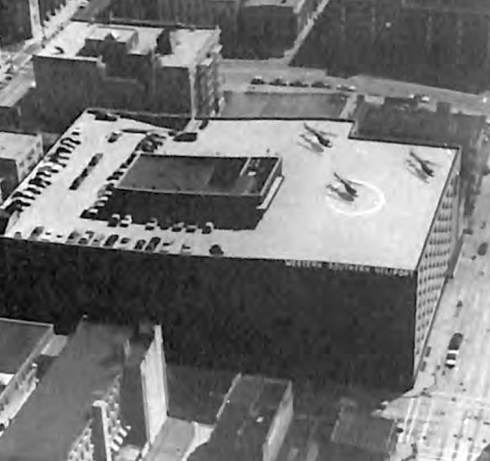
An undated aerial view looking northeast at the Cincinnati Western & Southern Heliport, from the 1975 Aerospace Industries Association Heliport Directory (courtesy of Jonathan Westerling).
Jonathan Westerling reported, “On 9/10/68 the Western & Southern Life Insurance Company
submitted a Notice of Landing Area Establishment to the FAA for a 'new landing area - heliport' for public & private use.
It was to be the first approved heliport to be located in downtown Cincinnati.
Operations commenced on 5/1/70 with twice-dally (rush hour) 'traffic-copter' reporting missions.
These were carrying Cincinnati Police Lt. Jim Stanley who reported traffic for WLW-AM, the #1 station at the time.
Stanley was their 'Eye in the sky' for 11 years, retiring in 1978 from radio & from the Cincinnati Police Department after 25 years.”
The first airfield directory listing which has been located of the Western & Southern Heliport
was in an addendum to the 1974 Airman's Information Manual as a new entry (according to Jonathan Westerling).
According to an article in the May 1989 Flying Magazine (according to Jonathan Westerling):
"With its 2,500-square-foot hangar equipped with complete maintenance facilities, and a passenger lounge with [elevator] access to the street,
pilots considered it one of the best rooftop heliports in the US, although it had no fueling facilities."
Jonathan Westerling reported, “The Western & Southern Heliport was situated on the upper level of a 10-story parking structure.
The deck elevation was approximately 125' above ground level.
Initially, almost the entire rooftop area was available for helicopter takeoffs, landings and parking.
Except for a relatively small space for automobile parking & the area of the hangar/waiting room,
usable space for helicopter operations was in excess of 35,700 square feet.
It was recorded that at one time (during a football game at adjacent Riverfront Stadium)
as many as 22 helicopters were simultaneously parked on the roof with sufficient space left for safe takeoff & landing operations.”
The earliest depiction which has been located of the Cincinnati Western & Southern Heliport was an undated aerial view looking northeast
from the 1975 Aerospace Industries Association Heliport Directory (courtesy of Jonathan Westerling).
It depicted 3 helicopters parked on the rooftop heliport, with one landing circle marking on the southern portion.
Jonathan Westerling reported, “Business was picking up for the heliport by the end of the 1970s,
then in 1980, Western & Southern demanded an almost 200% increase in rent.
Western & Southern planned to convert the now-vacant top level of its garage structure
exclusively to automobile parking & to use the hangar as a car maintenance facility.
The Fixed Base Operator, Cincinnati Airways, relocated to Lunken Airport.
However, in response to several requests from helicopter industry organizations, regional pilot groups, and the OOOT Division of Aviation,
Western & Southern agreed to maintain a portion of the original landing area open for 'Emergency Use Only'.
A section 60' x 80' was cordoned off in one corner for that purpose.
The manager of the parking operation was designated as the manager of the heliport also
and the State of OH kept the heliport certificate (license) in effect on that basis.
Notably, these proceedings were never reflected in any directory listings which continued to list the facility in its prior glory.”
Jonathan Westerling reported, “According to FAA Report DOT/FAA/PM-87/32, the Western & Southern Heliport lasted as long as it did
because of the support of the [Western & Southern] insurance company President.
He understood that the value of a heliport ls not always measured with dollars & cents on the bottom line.
He was like a shopping mall manager who realizes that the expensive parking lot outside
will never yield any return on the investment yet business would be practically impossible without it.
In much the same way, the services the heliport provided the community, in promoting commerce, improving public safety and enhancing the prestige & image of downtown Cincinnati,
were the intangible but nevertheless real benefits to be gained from having the heliport.
Unfortunately, when that gentleman died, so did the future of the heliport that bore his company's name.
His successor did not share his enthusiasm for rotary-wing aviation & withdrew the company's support.”
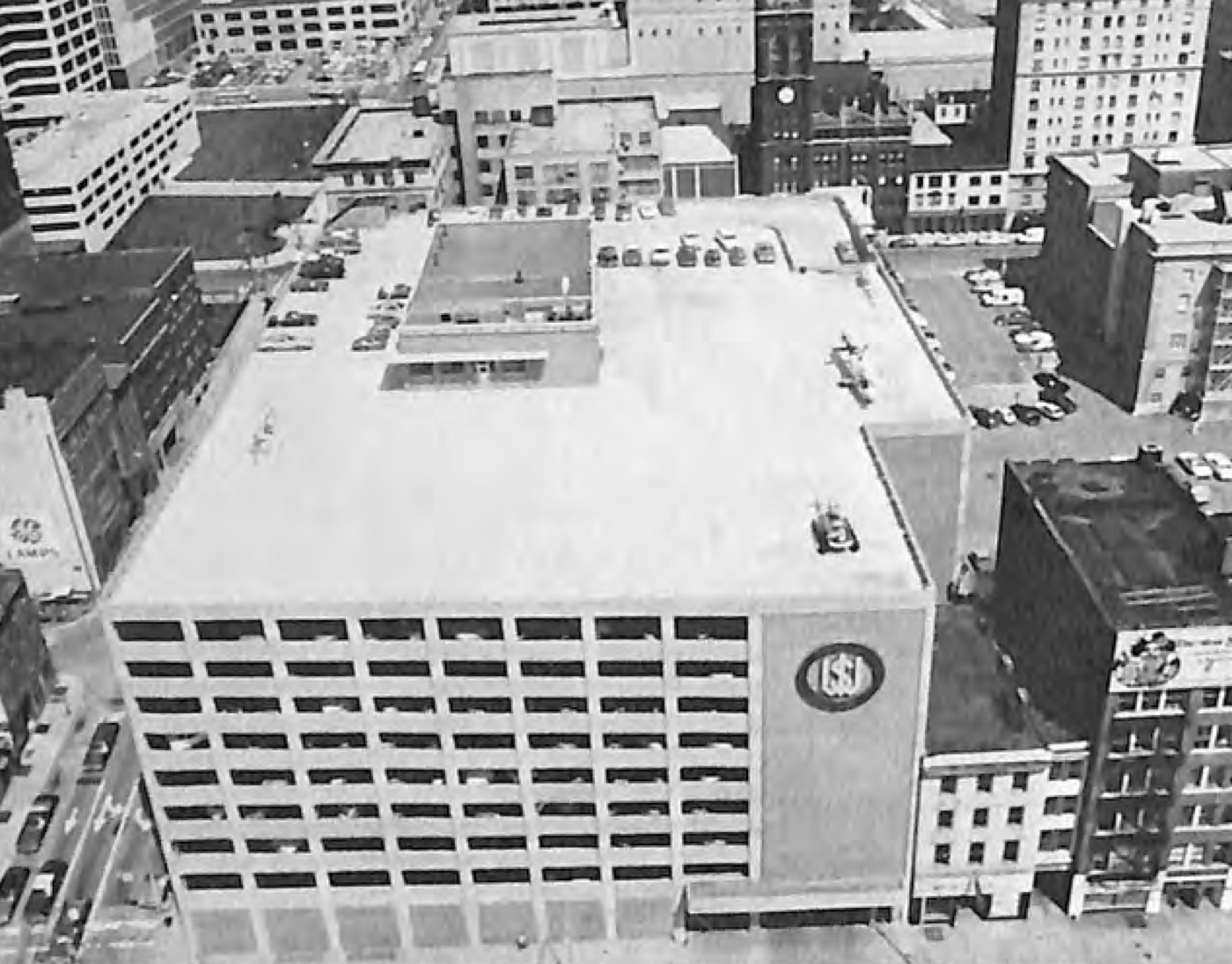
The last depiction which has been located showing the Cincinnati Western & Southern Heliport still in operation was an undated aerial view looking north
from the 1984 Aerospace Industries Association Heliport Directory (courtesy of Jonathan Westerling).
It depicted 2 or 3 helicopters parked on the rooftop heliport.
Jonathan Westerling reported, “In June 1984, the Western& Southern Life Insurance Company filed with the FAA
a Notice of Landing Area Proposal for Deactivation of the heliport.”
The demise of the Western & Southern Heliport was described as part of an article in the May 1989 Flying Magazine:
"While the heliport brought in about $10,000 / year, it could bring in $40,000 / year as a parking lot.
When the sponsoring businessman died, his successor chose cars over choppers."
An article in the 9/25/90 Cincinnati Enquirer announcing the closure of the heliport quoted the owner of the FBO:
"We might have been 10 years before our time," he said, "but now is when we need it."
"We've never had an incident or a problem."
Jonathan Westerling observed, “This was not due solely to good fortune.
The FBO's policy was to pursue to a successful resolution any sort of public relations problem, usually on a personal basis,
and this aggressive approach forestalled difficulty & prevented any real public opposition to helicopter operations in the neighborhood.”
The Western & Southern Heliport was not depicted on the November 1991 St. Louis Sectional Chart.
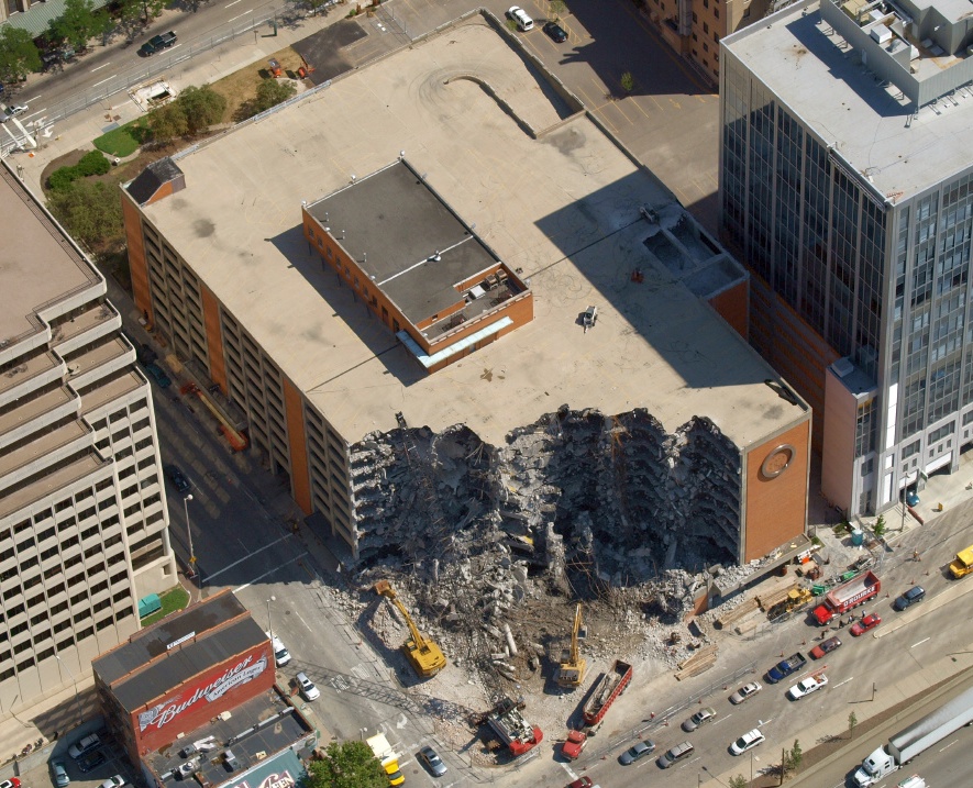
A 2007 aerial view looking northeast (courtesy of Jonathan Westerling) showed the parking garage of the former Cincinnati Western & Southern Heliport being demolished.
According to the O'Rourke Wrecking Company website, the parking garage was demolished to make way for the Queen City Square office tower.

A 2017 3-D aerial view looking northeast showed showed the the Queen City Square office tower which occupies the Cincinnati Western & Southern Heliport site.
Thanks to Jonathan Westerling for pointing out this heliport.
____________________________________________________
Wright's Farm Airfield, Cincinnati, OH
39.25, -84.504 (North of Downtown Cincinnati, OH)
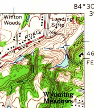
The 1961 USGS topo map depicted a single north/south “Landing Strip”.
A 1949 aerial view did not yet show any airfield at this location.
Bill Arrico reported, “The Wright Farm Airfield was originally owned by Reuben Robertson, President of Champion Paper.
The airstrip was part of his estate. He would have one of Champion Paper's pilots fly the company's Cessna 310 up from Lunken Airport
to pick him up and either fly him to his destination or back to Lunken where he could board one of the company's Lockheed PVs for a longer trip.
From 1955-57 Robertson was Deputy Secretary of Defense & he would very often commute daily to & from his home to Washington DC.
My father, Robert Arrico, was one of Champion Paper's pilots from 1956-60 & was often assigned to pick up Robertson at his home with the company's 310.”
The earliest depiction which has been located of Wright's Farm Airfield was a 1956 aerial photo, which depicted a single paved north/south runway.
There did not appear to be any hangars or other aviation infrastructure.
Bill Arrico reported, “On 3/13/60 Reuben Robertson was killed in an auto accident.
With the company's subsequent reorganization the aviation department was disbanded & the remaining airplanes were sold.”
The earliest depiction which is available of Wright's Farm Airfield was the 1961 USGS topo map,
which depicted a single paved north/south runway, labeled simply as “Landing Strip”.
Wright's Farm Airfield was evidently closed by 1962, as it was not depicted on the July 1962 Dayton Local Aeronautical Chart (courtesy of Mac Hays).
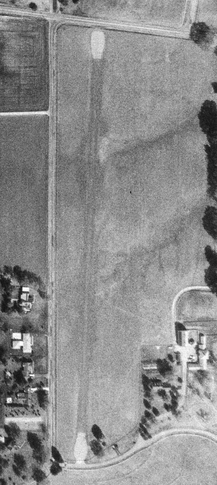
The earliest photo which has been located of the Wright's Farm Airfield was a 1963 ODoT aerial view (courtesy of Dennis Thompson).
It depicted a single unpaved runway, with paved turnaround pads at each end. There did not appear to be any hangars or other airfield improvements.
Wright's Farm Airfield was not depicted on the 1966 Cincinnati Sectional Chart.
A 1968 aerial photo showed the Wright's Farm Airfield runway width had decreased somewhat compared to the 1956 photo.
The 1982 USGS topo map continued to label the Wright's Farm Airfield runway as “Landing Strip”.

A 1994 USGS aerial view looking northwest depicted Wright's Farm Airfield as having a single runway, with the pavement of the runway ends & turnaround pads remaining somewhat less deteriorated than the middle of the runway.
There did not appear to be any hangars or other airfield improvements.
Wrights Farm Airfield was not depicted on the July 2009 Cincinnati Terminal Aeronautical Chart.
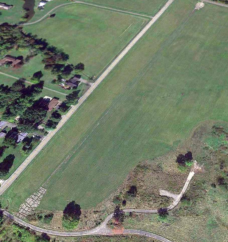
A 10/10/13 aerial view looking north west showed the Wright's Farm runway remained recognizable, but the pavement of each turnaround pad at each runway end was considerably deteriorated.
Note that the house & farm buildings adjacent to the runway had been removed.
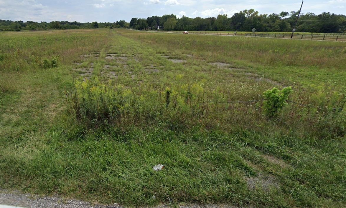
A 2023 photo looking south at the remains of the Wright's Farm runway pavement.
The site of Wright's Farm Airfield is located southeast of the intersection of McKelvey Road & Lakeridge Road.
Thanks to Roger Jollis for pointing out this airfield.
____________________________________________________
Lakewood Airpark, Cincinnati, OH
39.242, -84.582 (Northwest of Downtown Cincinnati, OH)
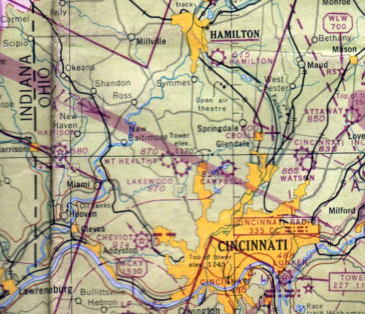
Lakewood Airport, as depicted the 1947 Cincinnati Sectional Chart (courtesy of Doug Ranz).
Lakewood Airport was not yet depicted on the October 1946 Cincinnati Sectional Chart (courtesy of Dick Merrill).
It was reportedly established in 1946, one of hundreds of U.S. airports established that year in the post-WW2 general aviation boom.
The earliest depiction which has been located of Lakewood Airpark was on the 1947 Cincinnati Sectional Chart (courtesy of Doug Ranz),
which depicted Lakewood as a commercial/municipal airport.
Merrie Beth Scherff recalled, “Lakewood Airport... My dad had a partnership in an airport with 2 friends - last names, Broxon & Heckinger (a WW2 pilot).
I believe they 'built' the airport in the late 1940s.”
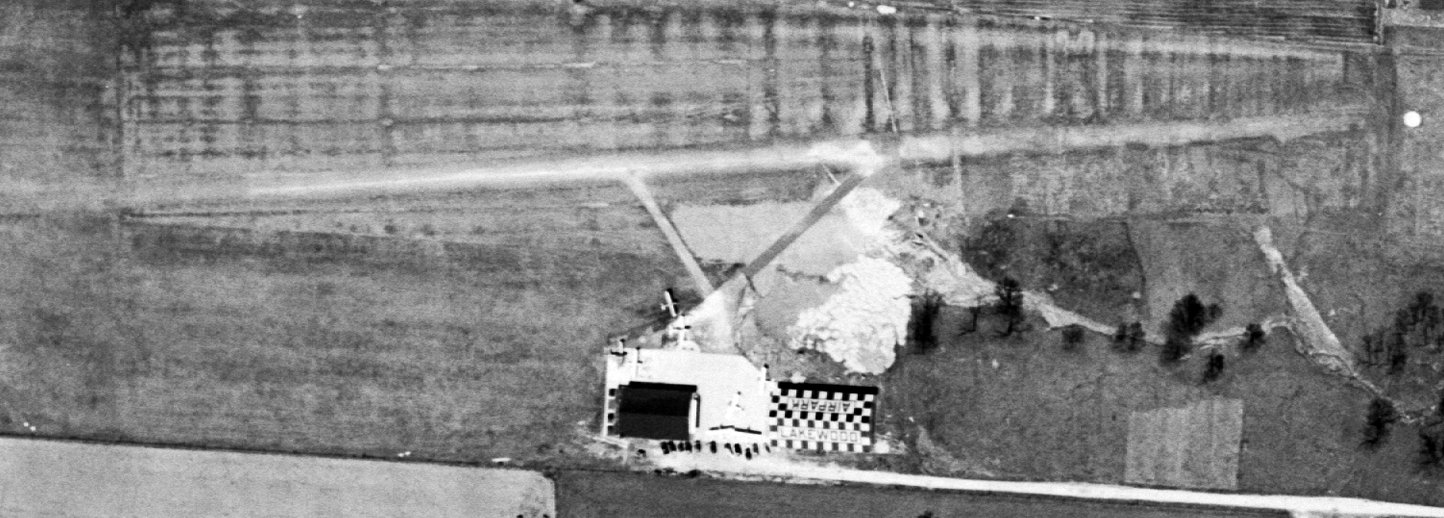
The earliest photo which has been located of Lakewood Airpark was a 4/9/49 USGS aerial view.
Lakewood was shown to have a single east/west runway, with 2 taxiways leading to a paved ramp & 2 hangars on the south side.
Six light single-engine aircraft were visible on the ramp.
Merrie Beth Scherff recalled, “Lakewood Airport... In the early 1950s my dad would take us kids over to the airport for visits.
I remember going down a long driveway off Pippin Road just north of Compton Road.
The Airpark doggie [was] a big black cutie, probably a Labrador...who was named Cessna, 'Cess' for short.
I remember a time when the planes were 'replaced' on the lot with Army trucks.”
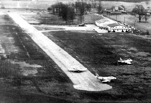
A January 1953 aerial view looking southeast at Lakewood Airpark, taken during undoubtedly this little airport's most famous episode,
in which 3 Air Force F-86 Sabre jet fighters were forced to land on the relatively short Lakewood runway.
Lakewood was shown to have a single east/west paved 2,100' runway, with 2 taxiways leading to a paved ramp & 2 hangars on the south side.
One single-engine taildragger was visible on the ramp.
The Sabres had run low on fuel during a flight from Scott AFB to Wright-Patterson AFB,
and successfully landed on Lakewood's 2,100' runway (much shorter than what would normally be used by a swept-wing jet fighter).
The issue then became how to get the jets out of the tiny airport.
According to R. L. Makinney, “L.t. Col. Raebel asked the aeronautical engineers at Wright Pat (the 'experts‘ in matters like this) what options we had.
Specifically, could the F-86 be modified to accept JATO (Jet Assisted Takeoff) bottles to shorten the takeoff roll? Their answer: 'No, not readily.'
They recommended the birds be hauled out on flatbed trailers after removing the wings.
At that point, ownership of the airplanes would pass from our squadron to Wright Patterson, i.e. we'd just lost 3 Sabres.
After carefully evaluating the situation, Lt. Col. Raebel decided to test 3 of the Sabres at Wright-Pat to determine the best short field takeoff procedure.
Based upon the tests, and after personally inspecting the [Lakewood] strip,
Lt. Col. Raebel drew heavily on his own experience in the F-86 & made his decision (I suspect there was also a silent prayer involved here).
Contrary to the advice of all the ‘experts', we'd fly the Sabres out!
The big day turned out to be cold & blustery. Typical February in Ohio - temperature about 30 deg F, wind gusts to 30 knots, and snow showers.
About 150 square feet of Pierced Steel Planking was laid on the muddy strip.
At a time coordinated with Greater Cincinnati Airport, each F-86 was pulled up onto the PSP, the engine was started, and the takeoff roll commenced.
One by one, the 3 Sabres accelerated to liftoff speed well short of the field boundary, then cleared the trees at the far end. WHEW!
Each one climbed to an altitude of several hundred feet, turned south across the Ohio River,
and landed at Greater Cincinnati Airport, where they were refueled & made ready for the return to George AFB.”
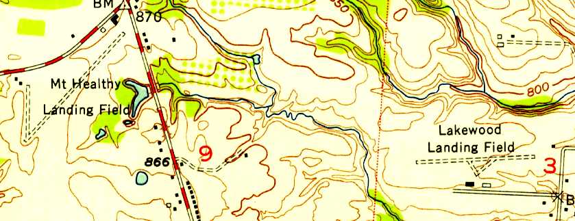
The 1953 USGS topo map depicted Lakewood Landing Field as having a single unpaved east/west runway, with 2 buildings on the south side.
It also depicted the Mt. Healthy Landing Field less than a mile to the west.
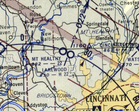
The last aeronautical chart depiction which has been located of Lakewood Airport was on the June 1955 Cincinnati Sectional Chart (courtesy of Ron Plante).
It depicted Lakewood as having a 2,200' paved runway.
Lakewood Airport reportedly ceased operations in 1956, after only a 1-decade run.
A 1956 aerial view depicted Lakeview Airport perhaps after it had closed, as no aircraft were visible on the field.
It had a single east/west runway, with 2 hangars on the south side, and the eastern hangar had a checkerboard-painted roof.
Lakewood Airport was no longer depicted on the June 1956 Cincinnati Sectional Chart (courtesy of Ron Plante).
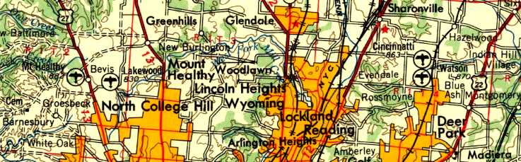
The last map depiction which has been located of the Lakewood Airport was on the 1957 USGS topo map.
Merrie Beth Scherff recalled, “Mr. Heckinger, the pilot, moved his family to Dayton around 1960 so... maybe that's when things changed.”
The 1963 USGS topo map still depicted the 2 hangars, labeling the western hangar as “Armory”.
Residential streets had converged on the airport site from both north & south, but nothing was depicted on the site of the runway.
A 1968 aerial photo showed the runway & hangars to remain intact,
although the runway was noticeably deteriorated compared to the 1956 photo,
and houses had been built right up to the northern & southern property borders.
Merrie Beth Scherff recalled, “Probably sometime in the late 1960s, a huge chunk of the property was sold off to developers.”
The last photo which has been located showing the remains of Lakewood Airpark was a 1970 aerial view,
which depicted the runway & hangars in the same fashion as seen in 1968.
The 1976 USGS topo map showed the location of the former runway had been covered with residential streets.
Merrie Beth Scherff recalled, “The Broxon family lived on the remainder of the property until 1993, in the same house.”
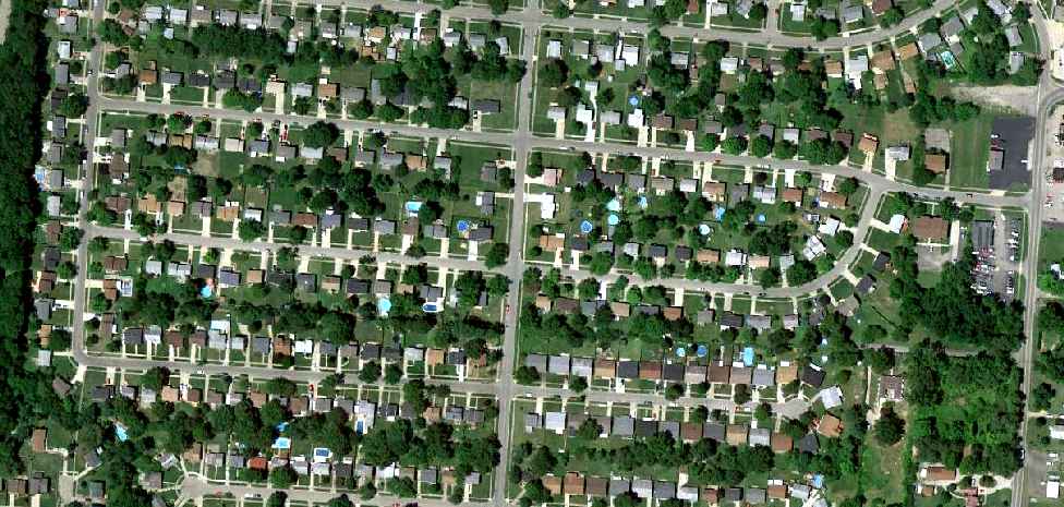
A 7/2/10 aerial view does not show any remaining trace of Lakewood Airpark.
Merrie Beth Scherff reported in 2018, the former Broxon family house “is still there.”
The site of Lakewood Airpark is located at the intersection of Burgess Drive & Windsong Drive, appropriately enough.
Thanks to Martin Dunks for pointing out this airport.
____________________________________________________
Cincinnati Incorporated Airport / Hugh Watson Field / Blue Ash Airport (I77/KISZ), Blue Ash, OH
39.25, -84.39 (Northeast of Cincinnati, OH)
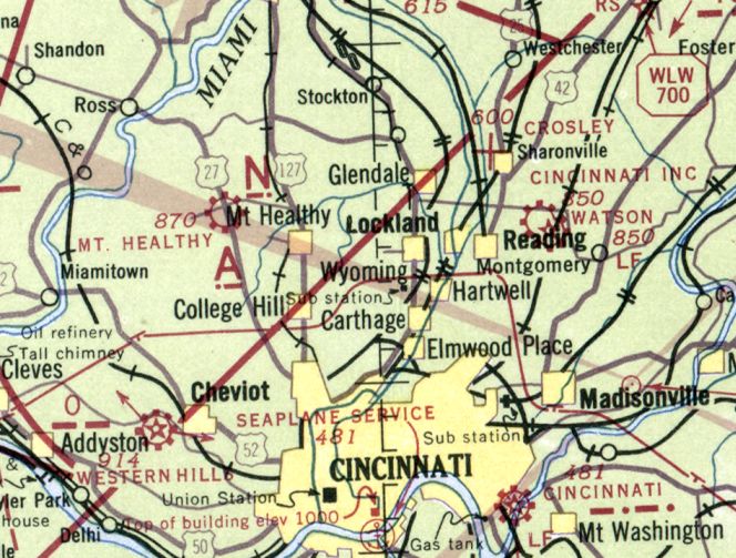
Cincinnati Inc. Airport, as depicted on the April 1941 Cincinnati Sectional Chart.
The history of the airport on the north side of this property is intertwined with another airport located only a mile to the south.
The histories of the 2 closely-located airports has become somewhat confused in other reporting,
as some other sources have failed to make the distinction that there were 2 separate airfields located in close proximity.
This has led to the reported history of this specific airport extending farther back in history than is correct,
as is indicated by dated aerial photos & maps.
A 1932 aerial view did not yet depict any airfield at this location – just farms & houses,
and the separate Watson Airport a mile to the south.
No airfield was depicted at this location on the 1939 USGS topo map.
The earliest depiction which has been located of Cincinnati Inc. Airport was on the April 1941 Cincinnati Sectional Chart,
which depicted Cincinnati Inc. as a commercial/municipal airport.
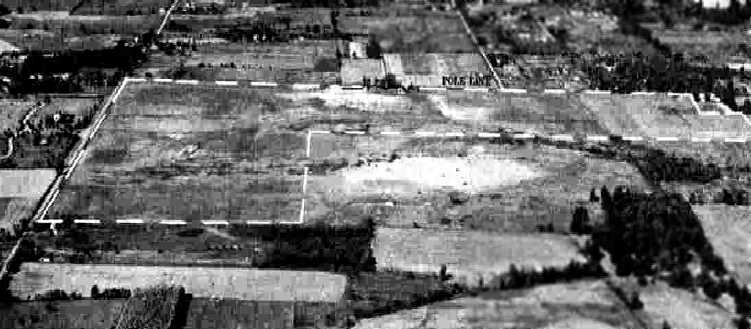
The earliest photo which has been located of Cincinnati Inc. Airport
was a 9/27/43 aerial view looking north from the 1945 AAF Airfield Directory (courtesy of Scott Murdock).
It depicted the “Cincinnati Airport, Inc.” as an L-shaped grass field with several buildings along the north side.
The 1943 Cincinnati Sectional Chart (courtesy of Dallam Oliver-Lee)
depicted “Cincinnati Inc.” as a commercial/municipal airport, with Watson Airport close-by to the south.
The 1945 AAF Airfield Directory (courtesy of Scott Murdock)
described the “Cincinnati Airport, Inc.” as a 184 acre rectangular property having 3 sod runways, with the longest being the 3,700' east/west strip.
The field was said to have 3 brick hangars, with the largest measuring 80' x 60',
and to be owned & operated by private interests.
The October 1946 Cincinnati Sectional Chart (courtesy of Dick Merrill)
depicted “Cincinnati Inc.” as a commercial/municipal airport, with Watson Airport close-by to the south.
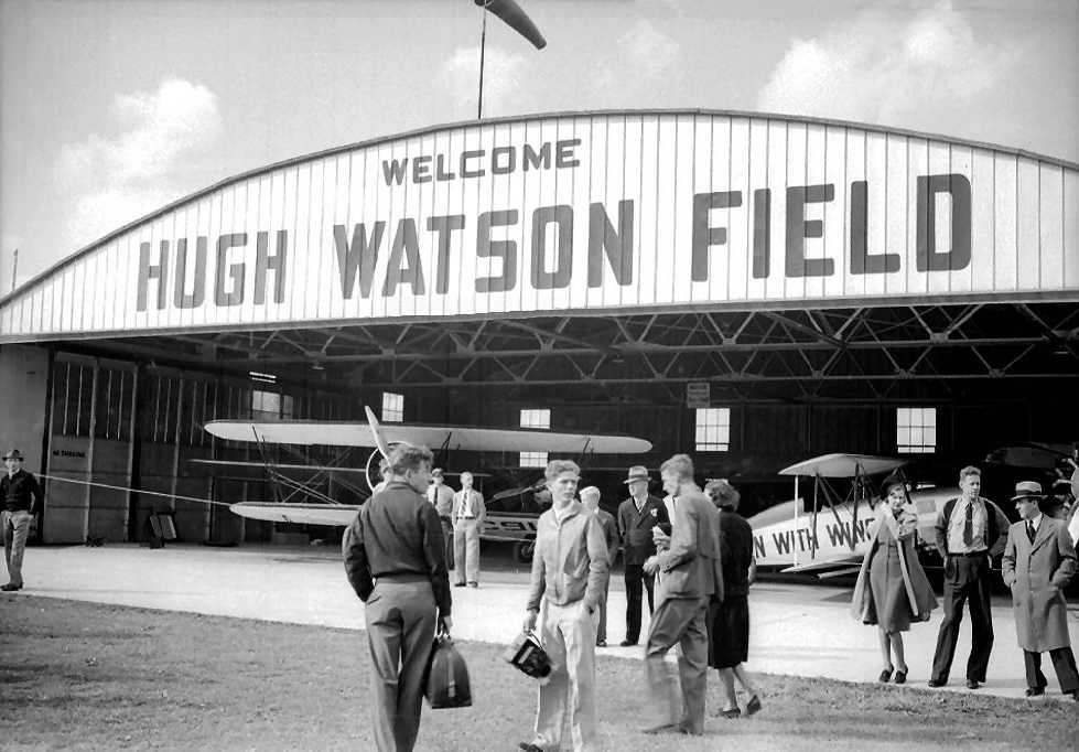
A circa 1940s photo of several unidentified biplanes inside a hangar emblazoned with “Hugh Watson Field”.
No airfield was depicted at this location on the 1948 USGS topo map.
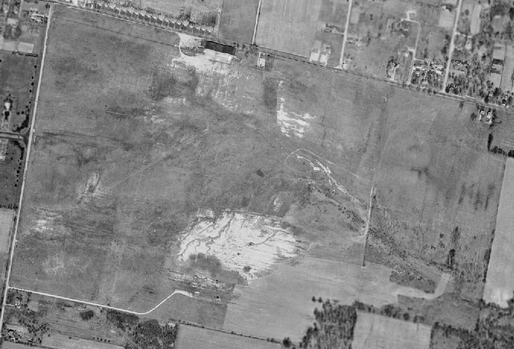
A 4/9/49 USGS aerial view (courtesy of Dallam Oliver-Lee) depicted Cincinnati Inc Airport as an open grass field with row of hangars on the north side.
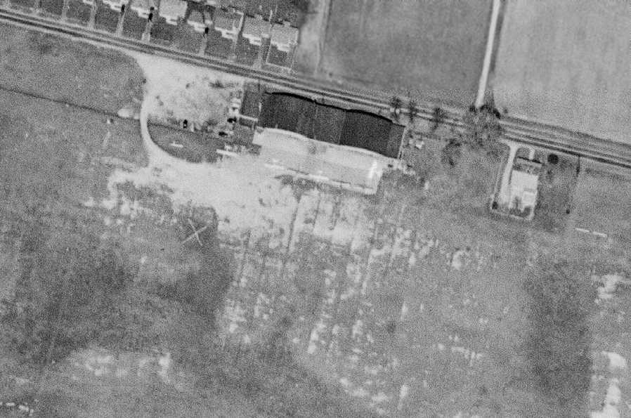
A closeup from the 4/9/49 USGS aerial view (courtesy of Dallam Oliver-Lee) showing 6 single-engine aircraft parked around the Cincinnati Inc hangars.
Blue Ash's Co-Op Aircraft Service hangar was built in 1950.
Dave Glos reported that his “father, Louis 'Moose' Glos ran the FBO” starting in 1952 at Blue Ash.
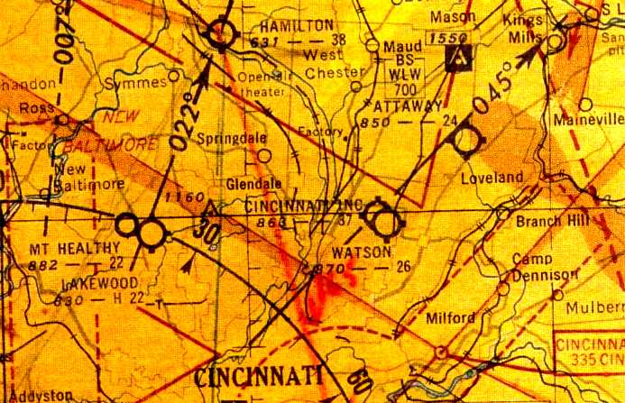
The June 1954 Cincinnati Sectional Chart (courtesy of David Stevenson)
depicted Cincinnati Inc Airport as having a 3,700' unpaved runway.
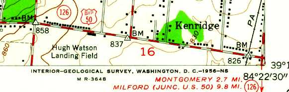
The 1955 USGS topo map depicted “Hugh Watson Landing Field” as an open area with several small buildings along the north side.
A 1956 aerial photo depicted a considerably-expanded Watson Airport,
with 3 distinct grass runways, and a dozen light planes parked around 2 hangars on the south side.
Another larger airport had appeared less than a half-mile to the northwest (which would eventually be known as Blue Ash Airport),
which would presumably replace Watson Airport.
The 1957 USGS topo map depicted “Cincinnati Incorporated Airport”, along with the adjacent Watson Airport to the south.
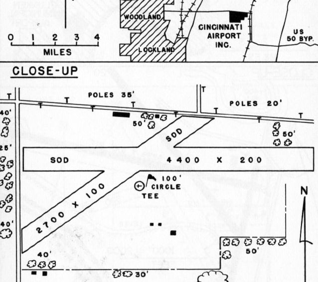
The 1960 OH Airport Directory (courtesy of Eileen Erickson) depicted “Cincinnati Airport Inc.” as having 2 sod runways, measuring 4,400' east/west & 2,700' northeast/southwest.
The manager was listed as Louis Blos, and the remarks included “Use pattern to avoid flying over airport [to the] south.”
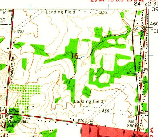
The 1961 USGS topo map depicted 2 unpaved runways (at the top), labeled simply as “Landing Field”.

The July 1962 Dayton Local Aeronautical Chart (courtesy of Mac Hays) depicted Cincinnati Inc Airport as having a 4,400' unpaved runway.
A 4/1/64 USGS aerial view (courtesy of Dallam Oliver-Lee) showed the field still having unpaved runways.
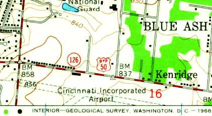
The 1965 USGS topo map depicted “Cincinnati Incorporated Airport” as having 2 unpaved runways.
The 1971 USGS topo map depicted an unpaved runway, labeled simply as “Landing Field”.
A 5/7/74 USGS aerial view (courtesy of Dallam Oliver-Lee) showed the field still having unpaved runways,
but construction was underway to the south of a new northeast/southwest runway.
The 1975 USGS topo map depicted an unpaved runway, labeled simply as “Landing Field”,
but also showed a new northeast/southwest runway “Under construction”, 1/3 of a mile to the south.
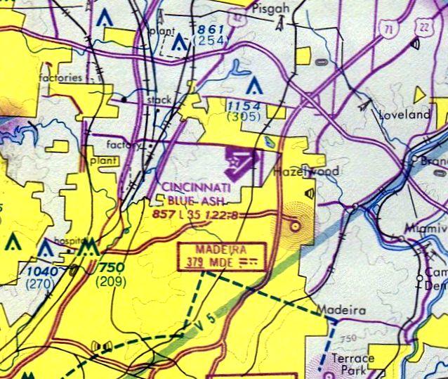
The August 1976 Cincinnati Sectional Chart (courtesy of Mitchell Hymowitz) depicted Cincinnati Blue Ash Airport as having 2 paved runways,
with the longest being 3,500'.
An 11/17/79 USGS aerial view (courtesy of Dallam Oliver-Lee) showed Blue Ash to have a northeast/southwest paved runway.
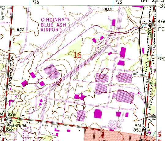
The 1981 USGS topo map depicted Cincinnati Blue Ash Airport as having a single paved northeast/southwest runway,
connected by 2 long paved taxiways to a small ramp & a cluster of small buildings on the north side.
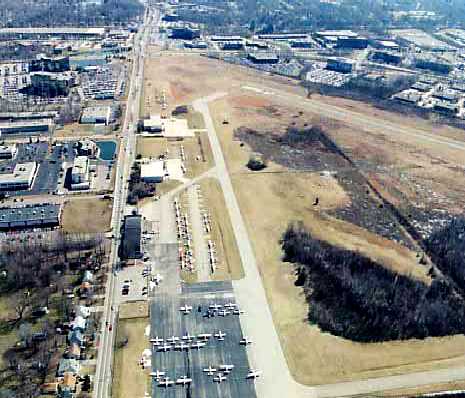
A circa 1980s aerial view looking east at a Blue Ash Airport ramp crowded with light aircraft.
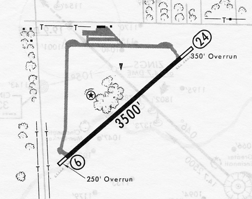
A 3/12/82 airport directory (courtesy of John Kielhofer) depicted Cincinnati Blue Ash Airport as having a single 3,500' paved Runway 6/24,
connected by 2 long paved taxiways to a ramp & 2 small buildings on the north side.
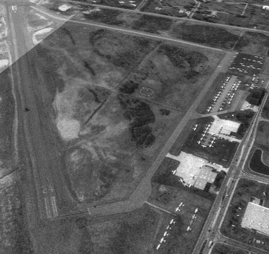
The 4/1/94 USGS aerial view looking southwest showed Blue Ash Airport to have dozens of light aircraft.
Andrew Kahn recalled, “Cincinnati/Blue Ash Airport... I trained there in the mid-1990s.
In my logbook... The identifier for Blue Ash was changed on 5/1/94 from I77 to KISZ.
In fact, the old guys always called it 'Item-77'. I never heard anyone refer to it as 'India-77' or 'Indigo-77'.
It was also the launching spot for the local Cincinnati traffic copter for 700WLW.”
According to a 2012 Cincinnati.com article by Mark Hansel, Blue Ash conducted 35,000 landings & take-offs in 1995.
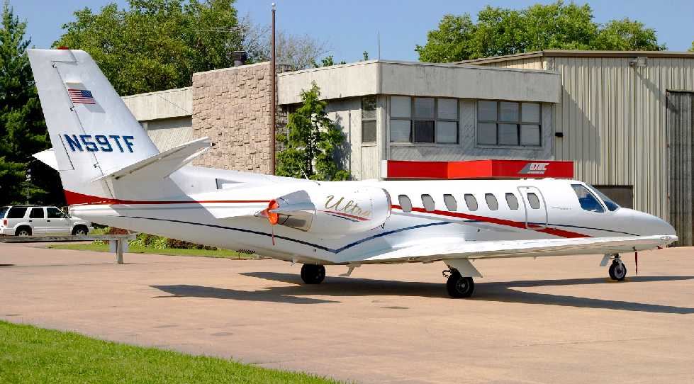
A 6/23/04 photo by Louis Rivera of a 1997 Cessna Citation 560 Ultra business jet at Blue Ash Airport.
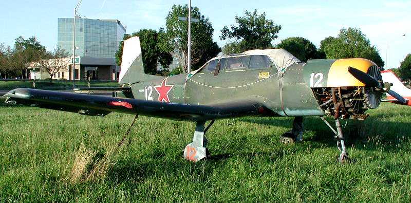
A 7/24/04 photo by Collin Gray of N63391, a 1982 Nanchang China CJ-6, C/N: 3632012 at Blue Ash Airport.
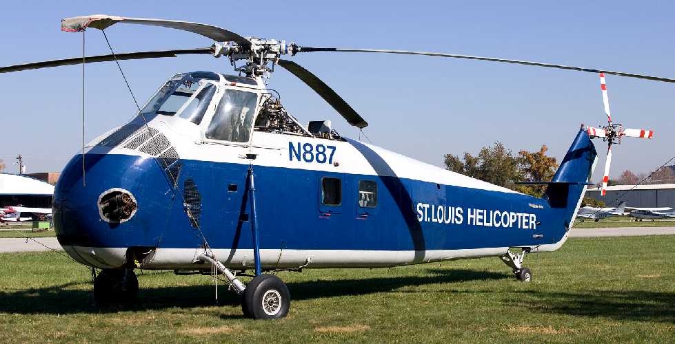
A 11/2/05 photo by Jeffrey Swayze of St. Louis Helicopter Sikorsky S-58B N887 (cn 58-0482) at Blue Ash Airport.
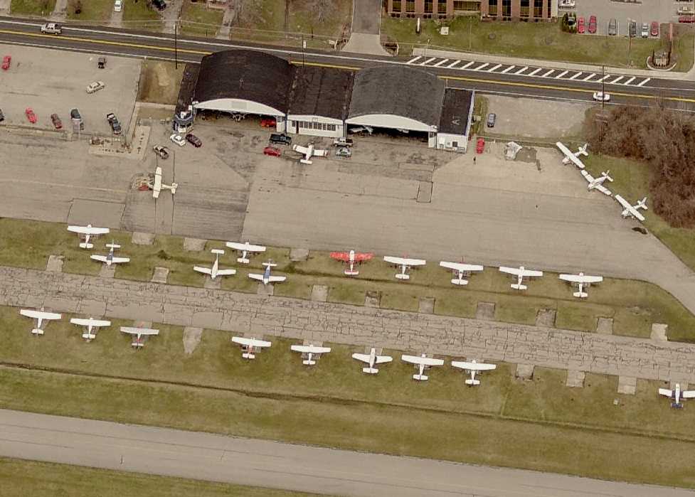
A circa 2007-2011 aerial view looking north at the well-used ramp at Blue Ash Airport.
According to a 2012 Cincinnati.com article by Mark Hansel,
“Cincinnati sold 130 of the airport's 230 acres to Blue Ash in 2007, and the City planned to reconfigure the airport on its remaining 100 acres.”
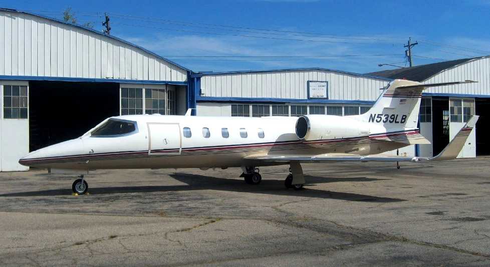
A 9/22/09 photo by Bob Simmermon of N539LB, a 1993 Learjet 31A, C/N 078 at Blue Ash Airport.
Not a very common sight to see a swept-wing jet at an airport with only a 3,500' runway.
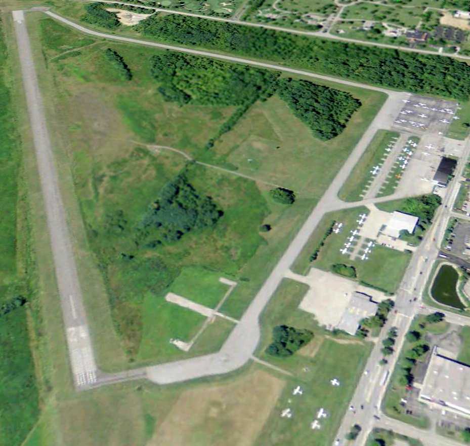
A 10/28/11 aerial view looking southwest showed Blue Ash Airport to have dozens of light aircraft.
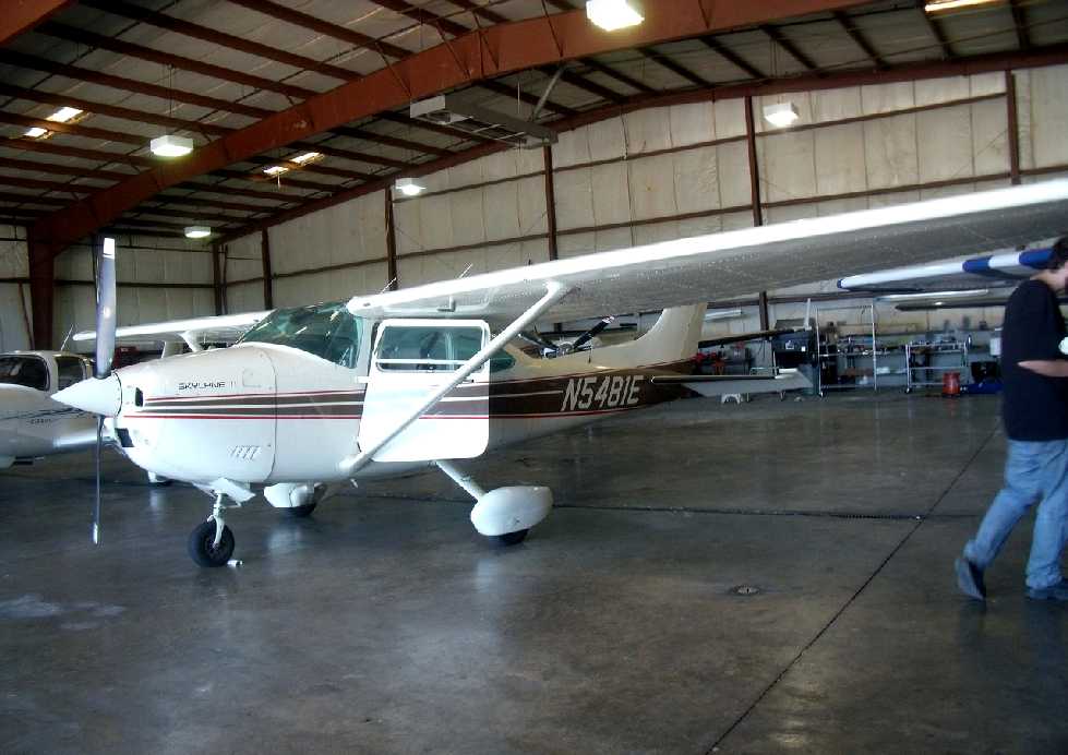
A 6/15/12 photo by Christian Maurer of Duncan Latta's N5481E, a Cessna 182R Skylane, C/N 18268325, inside a Blue Ash hangar.
This Cessna shortly thereafter became the last plane to depart Blue Ash before the airport's closure.
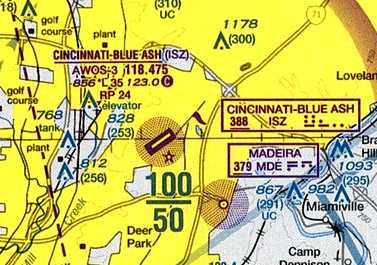
The 2012 Cincinnati Terminal Aeronautical Chart depicted Blue Ash as having a single 3,500' paved runway.
According to a 2012 Cincinnati.com article by Mark Hansel,
“The City of Cincinnati decided earlier this year to close the general aviation airport.
City officials want to use its aviation resources for Lunken Airport, which is much larger & more successful than the Blue Ash facility.
The City of Blue Ash plans to turn the part of the airport that houses its 3 fixed-base operators into a park.
Use of the Blue Ash Airport has declined steadily. Last year there were only 15,000 landings & take-offs there.
In a March 9 report to City Council, Cincinnati City Manager Milton Dohoney said operating the airport over the next 10 years would cost $190,000 a year
because of $40,000 annual losses in revenue & the cost of FAA-required improvements.
A partial reconfiguration of the airport on the city's 100 acres would cost $2.2 million, while a full reconfiguration would run $16 million.
Last month, Cincinnati City Hall restructured the $37.2 million sale so that the proceeds would be available to help fund the $110 million-plus streetcar project.
City officials previously said they hoped to use money from the airport’s sale to cover payments on about $11 million in streetcar bonds.
The Federal Aviation Administration, however, raised objections,
telling City Hall it would have to keep the sale revenue within its airport system, including Lunken in the East End.
By rescinding the original sale & approving a new deal with some procedural changes, the city was able to sidestep that problem.
Wednesday [8/29/12] is the last day of operations at Blue Ash Airport.”
Dave Glos reported that his “father, Louis 'Moose' Glos ran the FBO” until 2012 at Blue Ash.
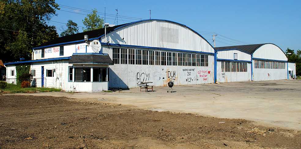
A sad 8/29/12 photo by K. Kuhn of Blue Ash's 1950 Co-Op Aircraft Service hangar, on the day of the airport's closure.
The hangar was decorated with laments of those who loved this little airport.
It would be torn down less than a month later.
Duncan Latta reported that “my plane N5481E [pictured several paragraphs above]...
was the last plane to depart the airport before it closed 8/29/12, less than a minute before it closed at 8:00.”
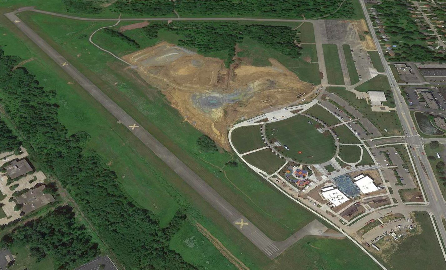
A sad sight for anyone who appreciates general aviation: a 2016 aerial view looking west showed the site of Blue Ash Airport being covered by new construction.
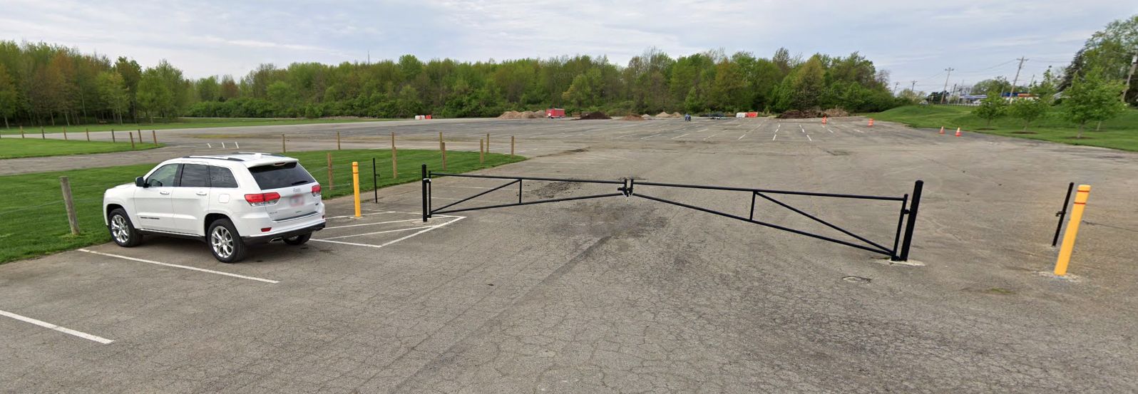
A 2019 photo looking west at the last remnant of the Blue Ash Airport ramp.
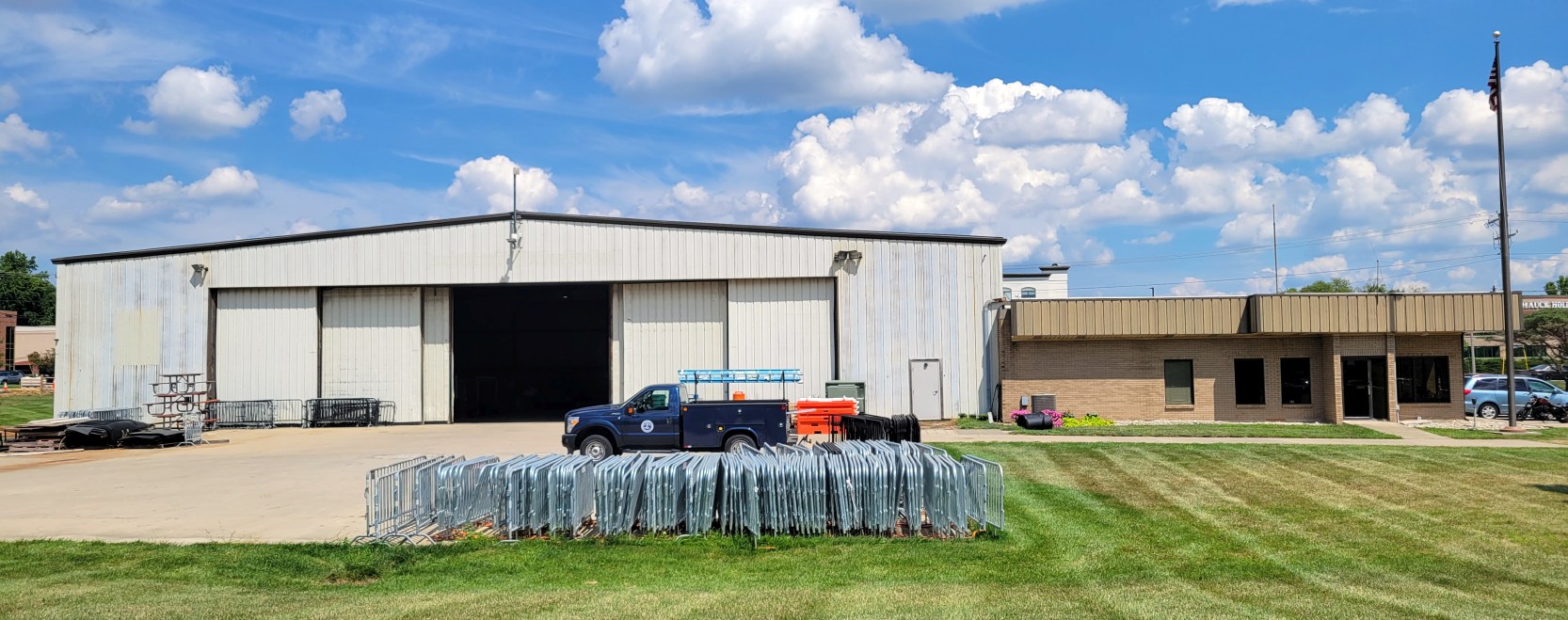
An 8/19/22 photo by Noah Stegman Rechtin of the last remaining hangar on the former Blue Ash Airport.
Noah reported, “It's now used to store maintenance equipment for Summit Park. It was previously the home of Schmidt Aviation Incorporated."
Blue Ash Airport is located southeast of the intersection of Glendale Milford Road & Plainfield Road.
____________________________________________________
Grisard Field / Watson Airport / Parks Watson Landing Field / Blue Ash Airport, Blue Ash, OH
39.238, -84.382 (Northeast of Cincinnati, OH)
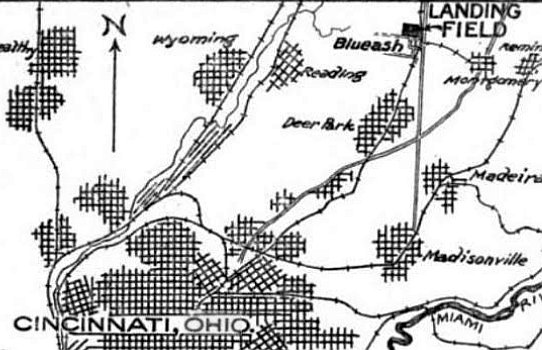
Grisard Field, as depicted on the 1/2/25 Commerce Department Airway Bulletin (courtesy of Mike Denja).
The history of the airport on the south side of this property is intertwined with another airport located only a mile to the north.
The histories of the 2 closely-located airports has become somewhat confused in other reporting,
as some other sources have failed to make the distinction that there were 2 separate airfields located in close proximity.
According to the Blue Ash Airport website, “The airport was originally known as Grisard Field
and was founded in 1921 by the Grisard Company (partially owned by Eshelby Lunken) in an attempt to lure lucrative Federal funds & airmail routes to Cincinnati.
It also housed the 359th Army Reserve Observation Squadron.
The airfield was commercially leased the next year to brothers Hugh & Parks Watson
and it became a favorite place to visit for weekend airplane rides & flying circus air shows.”
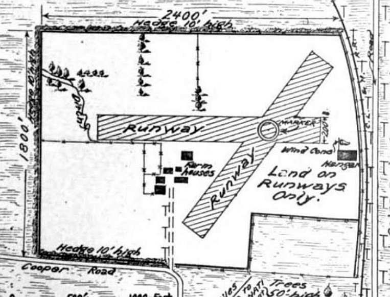
The earliest depiction which has been located of Grisard Field was on the 1/2/25 Commerce Department Airway Bulletin (courtesy of Mike Denja).
It described Grisard Field as a government airfield leased by the Army Air Service & available for municipal & commercial purposes.
It was said to have 2 sodded runways, measuring 2,400' east/west & 1,800' northeast/southwest, with a hangar on the east side.
According to the Blue Ash Airport website, “In 1925, Eshelby Lunken & the Grisard Company sold the Blue Ash airfield to the Watson brothers.
Grisard Field now became Watson Field.”
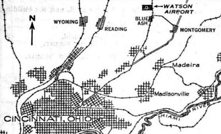
The earliest depiction which has been located of Watson Airport was on the 4/30/29 Commerce Department Airway Bulletin (courtesy of Mike Denja).
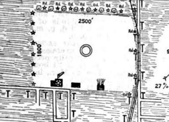
Watson Airport was described in the 4/30/29 Commerce Department Airway Bulletin (courtesy of Mike Denja) as a commercial airport owned & operated by Watson Airport Inc.
It was said to consist of a 102 acre rectangular sod field, measuring 2,500' east/west.
Three hangars were depicted on the south side, the largest measuring 120' x 60'.
The earliest photo which has been located of Watson Airport was a 1932 aerial view,
showing the field to have a single east/west grass runway with several small buildings & a few light planes along the south side.
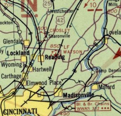
The earliest aeronautical chart depiction which has been located of Watson Airport was on the 1934 Cincinnati Sectional Chart.
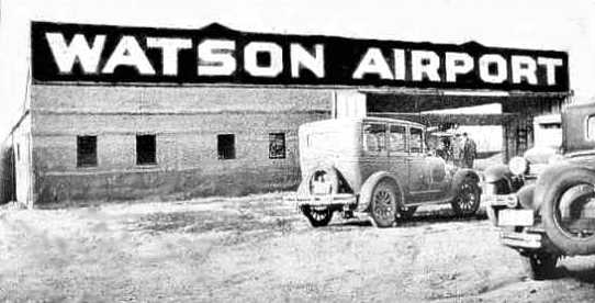
A circa 1930s photo of a hangar emblazoned with “Watson Airport”.
According to the Blue Ash Airport website, “After the 1937 flood completely submerged Lunken Airport,
Cincinnati civic leaders reconsidered the Blue Ash airport as the most promising location.
Starting in 1938, Cincinnati politicians, civic leaders & others fought with each other
in attempts to build a large commercial airport for the City of Cincinnati at the Blue Ash location.
Through the years, failed bond issues, political in-fighting & disagreements failed to produce any firm decision on building at the Blue Ash location.”
The April 1941 Cincinnati Sectional Chart depicted Watson as a commercial/municipal airport, with Cincinnati Inc. Airport close-by to the northwest.
The 1943 Cincinnati Sectional Chart (courtesy of Dallam Oliver-Lee)
depicted Watson as a commercial/municipal airport, with Cincinnati Inc. Airport close-by to the northwest.
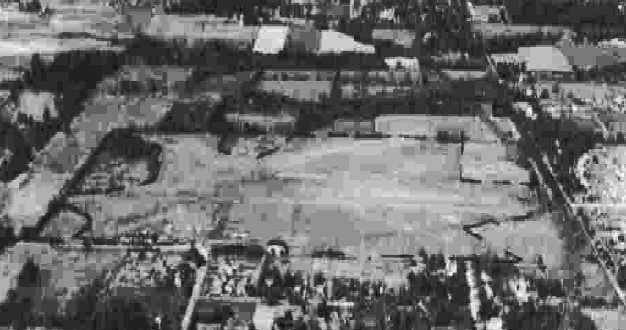
A 9/27/43 aerial view looking north at “Parks Watson Airport” from the 1945 AAF Airfield Directory (courtesy of Scott Murdock).
The 1945 AAF Airfield Directory (courtesy of Scott Murdock) described Parks Watson Airport
as a 97 acre rectangular property having a single 2,450' east/west cinder runway.
The field was said to have 2 hangars, the largest being a 120' x 60' stone building,
and to be owned & operated by private interests.
According to Martha Lunken, “Those 2 hangars were occupied by the T. W. Smith Engine Company which later moved to Lunken Airport.”
The October 1946 Cincinnati Sectional Chart (courtesy of Dick Merrill) depicted Watson as a commercial/municipal airport.
According to the Blue Ash Airport website, “The Watson brothers sold the Blue Ash airport to the City of Cincinnati in 1946
and the airfield was renamed the Blue Ash airport.
Throughout the 1950s, there were still political efforts to build the 'Cincinnati Airport' in Blue Ash
but Blue Ash civic leaders & residents fought any major airport redevelopment issues.
As time went by, suburbs & businesses expanded & any chance for Blue Ash to become the site of a major airport dwindled.”
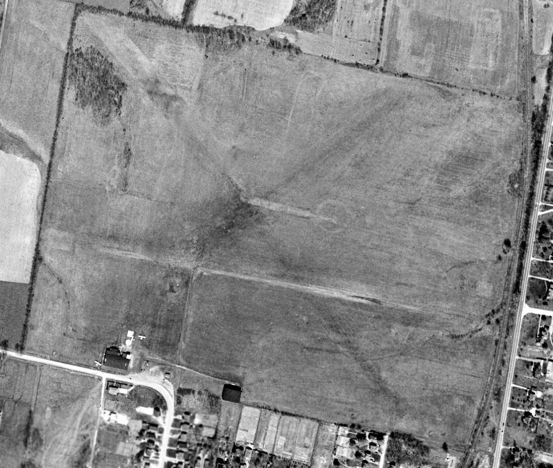
A 4/9/49 USGS aerial view (courtesy of Dallam Oliver-Lee) depicted Watson as an open grass field on which were discernible 3 runways,
with 2 hangars on the south side near which were visible 3 single-engine aircraft.
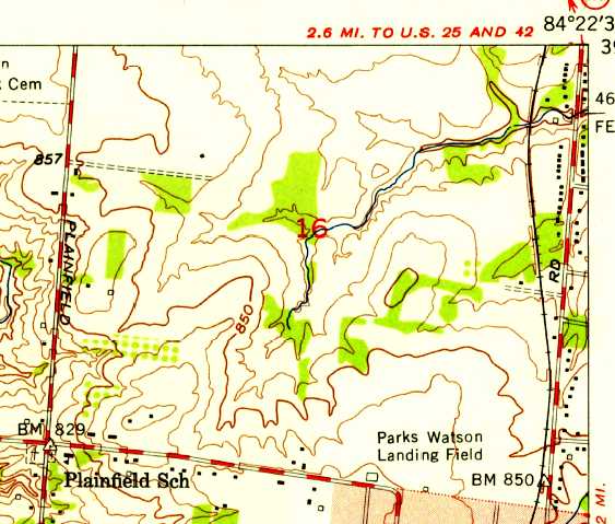
The 1953 USGS topo map depicted “Park Watson Landing Field” as an open area with several small buildings along the south side.
The last aeronautical chart depiction which has been located of Watson Airport
was on the June 1954 Cincinnati Sectional Chart (courtesy of David Stevenson).
It depicted Watson as having a 2,600' unpaved runway.
A 1956 aerial photo depicted a considerably-expanded Watson Airport,
with 3 distinct grass runways, and a dozen light planes parked around 2 hangars on the south side.
Another larger airport had appeared less than a half-mile to the northwest (which would eventually be known as Blue Ash Airport),
which would presumably replace Watson Airport.
The last map depiction which has been located which still labeled the Watson Airport was on the 1957 USGS topo map.
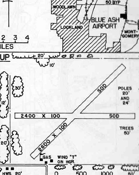
The 1960 OH Airport Directory (courtesy of Eileen Erickson) depicted “Blue Ash Airport” as having 2 sod runways, measuring 2,600' northeast/southwest & 2,400' east/west.
The manager was listed as W.B. Kennedy,
and the remarks included “Use pattern to avoid flying over airport [to the] north side.”
A 4/19/60 USGS aerial view (courtesy of Dallam Oliver-Lee) depicted Watson as a well-used airport,
with 30 light aircraft visible on the south side.
The 1961 USGS topo map depicted 2 unpaved runways (at the bottom) labeled simply as “Landing Field”, with several small buildings along the south side.
The July 1962 Dayton Local Aeronautical Chart (courtesy of Mac Hays)
depicted Cincinnati Blue Ash Airport as having a 2,900' unpaved runway.
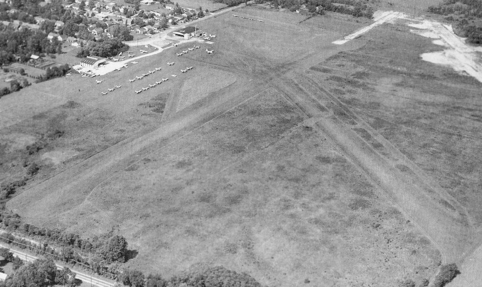
An undated aerial view by Tom Root looking northwest at Blue Ash Airport from the October 1962 issue of “The Flyer” magazine (courtesy of Daun Yeagley).
It depicted Blue Ash Airport as having 2 unpaved runways, with the longest described as 2,900'. Note also what appears to the start of construction for the paved northeast/southwest runway (at top-right).
Operator T.W. Smith Aircraft Inc. was said to be very busy, and the airport manager was listed as W.B. Kennedy.
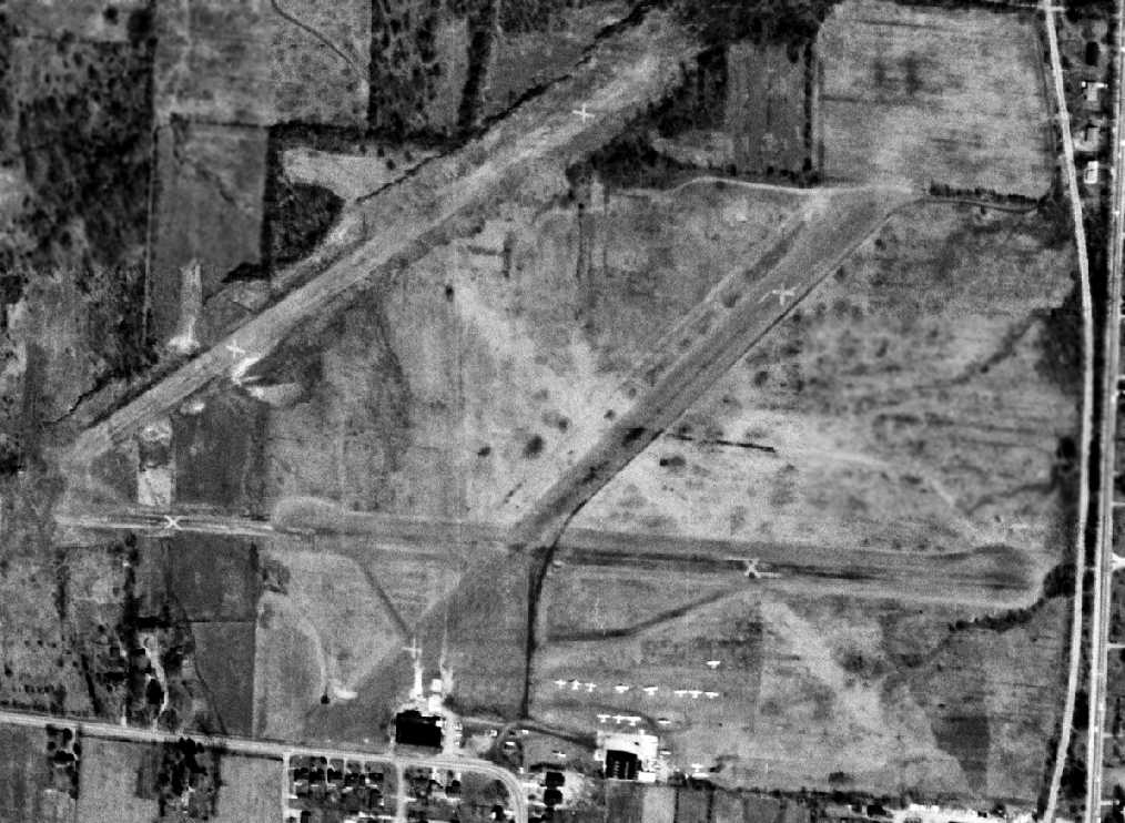
The last photo which has been located showing Watson Airport still intact was a 4/1/64 USGS aerial view (courtesy of Dallam Oliver-Lee).
Paradoxically, it depicted closed-runway “X” symbols on both runways, yet 13 light aircraft were still visible on the field.
Another odd observation is that a 3rd runway, a parallel northeast/southwest runway had been added at some point between 1962-64, but it also was marked with closed-runway X symbols.
Watson Airport was evidently closed at some point between 1964-68,
as a 1968 aerial photo showed several commercial buildings & new streets covering the airport property.
A 4/10/70 USGS aerial view (courtesy of Dallam Oliver-Lee) showed Watson's eastern hangar remained standing,
but commercial buildings covered most of the site.
A 1994 USGS aerial view (courtesy of Dallam Oliver-Lee) showed the last hangar had been removed at some point between 1970-94.
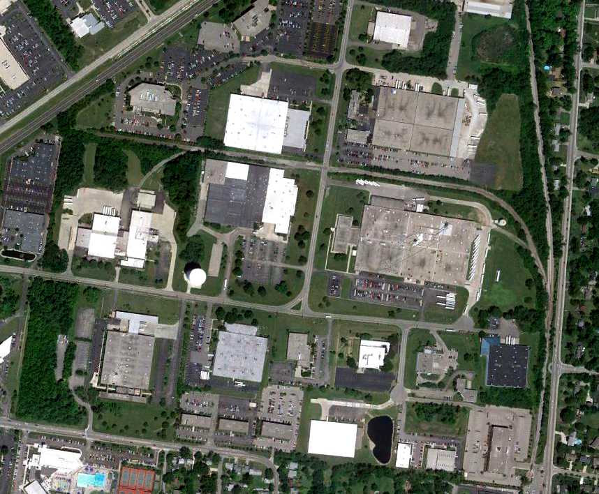
A 7/2/10 aerial view does not show any remaining trace of Watson Airport.
The site of Watson Airport is located at the intersection of Alliance Road & Malasbury Road.
____________________________________________________
Or if you prefer to contact me directly concerning a contribution (for a mailing address to send a check),
please contact me at: paulandterryfreeman@gmail.com
If you enjoy this web site, please support it with a financial contribution.
____________________________________________________
This site covers airfields in all 50 states.