
Abandoned & Little-Known Airfields:
Northeastern California
© 2002, © 2024 by Paul Freeman. Revised 7/5/25.
This site covers airfields in all 50 states: Click here for the site's main menu.
____________________________________________________
Please consider a financial contribution to support the continued growth & operation of this site.
For a 10th year, the CA pages of this website are sponsored by the California Pilots Association:
Alturas #2 Airport / Devil's Garden Airport (revised 6/1/21) - Cheim Airport (revised 3/7/20) - Chico Aux AAF #3 / Deer Creek Ranch Airport (revised 7/5/25)
Foresthill Airport (revised 1/28/21) - Grass Valley Airport / Gilmore Airport (revised 12/31/19) - Louisiana Pacific Mill Airfield (revised 7/22/24)
Nevada City Airport (revised 7/5/25) - Oroville Aux AAF #5 (revised 12/29/18) - Secret Valley Intermediate Field (added 11/24/20)
Truckee Intermediate Field (revised 12/28/22) - Westwood Airport (1st location) (revised 9/22/18) - Westwood Airport (2nd location) (revised 7/5/25)
____________________________________________________
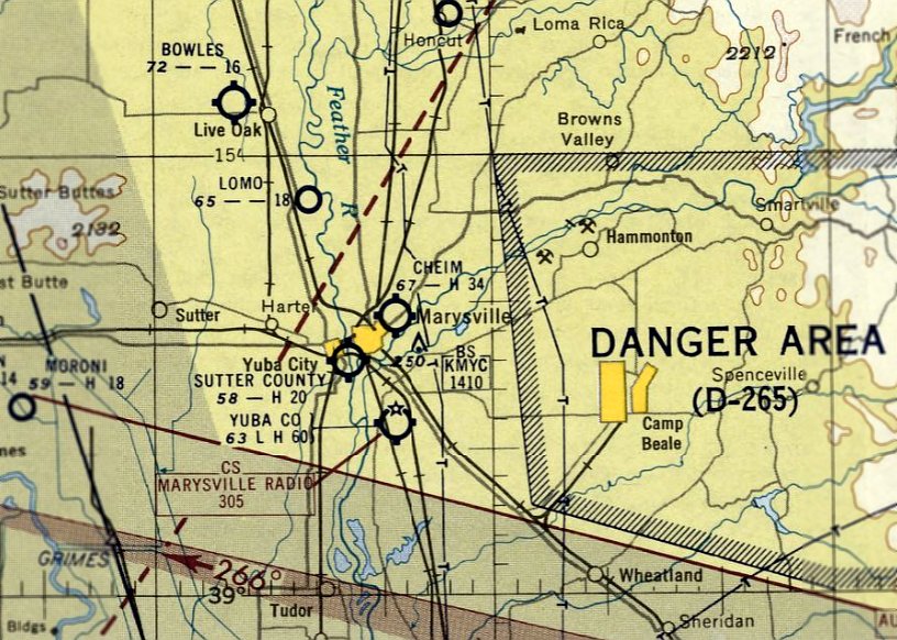
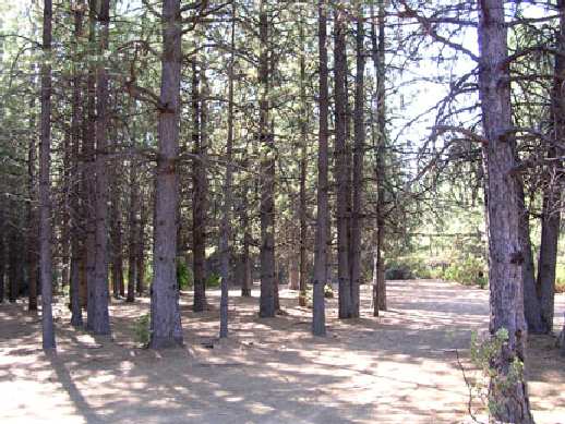
Secret Valley Intermediate Field, Secret Valley, CA
40.536, -120.252 (Northeast of Sacramento, CA)
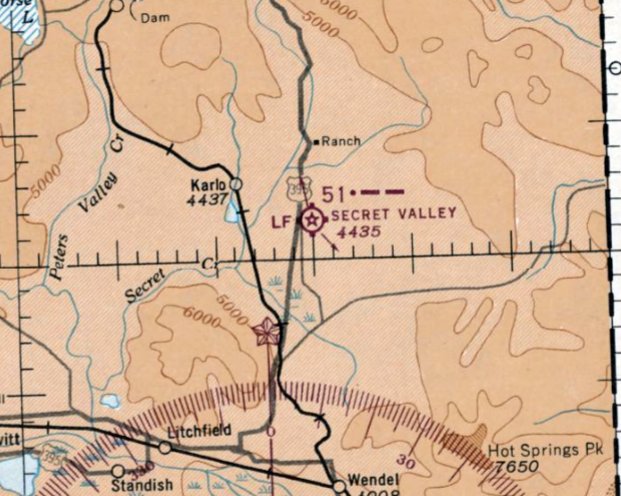
Secret Valley Intermediate Field, as depicted on the April 1944 Mt. Shasta Sectional Chart.
Photo of the airfield while in use has not been located.
Secret Valley Intermediate Field was evidently established at some point between 1943-44,
as it was not yet depicted on the October 1943 Mt. Shasta Sectional Chart.
The earliest depiction which has been located of Secret Valley Intermediate Field was on the April 1944 Mt. Shasta Sectional Chart.
It depicted Secret Valley as Site 51.
Other Intermediate Fields were constructed by the Department of Commerce for the emergency use of commercial aircraft flying along airways between major cities.
However, the justification for Secret Valley Intermediate Field isn't apparent, as it was not located along a commercial airway.

The 1945 AAF Airfield Directory (courtesy of Scott Murdock) depicted Secret Valley Intermediate Field as having a 5,000' bare northeast/southwest runway, with no other improvements.
It was described as a 506 acre irregularly-shaped area, owned by the US Government, and operated by the Civil Aeronautics Administration.
The 1947 Decker's Pacific States Airfield Directory (courtesy of Jonathan Westerling) described Secret Valley as a CAA Intermediate Site, with one 5,000' sod runway.
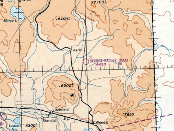
The last aeronautical chart depiction which has been located of Secret Valley Intermediate Field was on the March 1950 Mt. Shasta Sectional Chart.
It depicted “Secret Valley (CAA)” as having a 5,000' unpaved runway.
Secret Valley Intermediate Field was evidently closed at some point in 1950,
as it was no longer depicted on the September 1950 Mt. Shasta Sectional Chart.
Many of the more rural Intermediate Fields had become unnecessary due to advances in reliability of airline aircraft.
The earliest topo map depiction which has been located of Secret Valley Intermediate Field was on the 1954 USGS topo map.
It depicted a single northeast/southwest runway, generically labeled “Airstrip”.
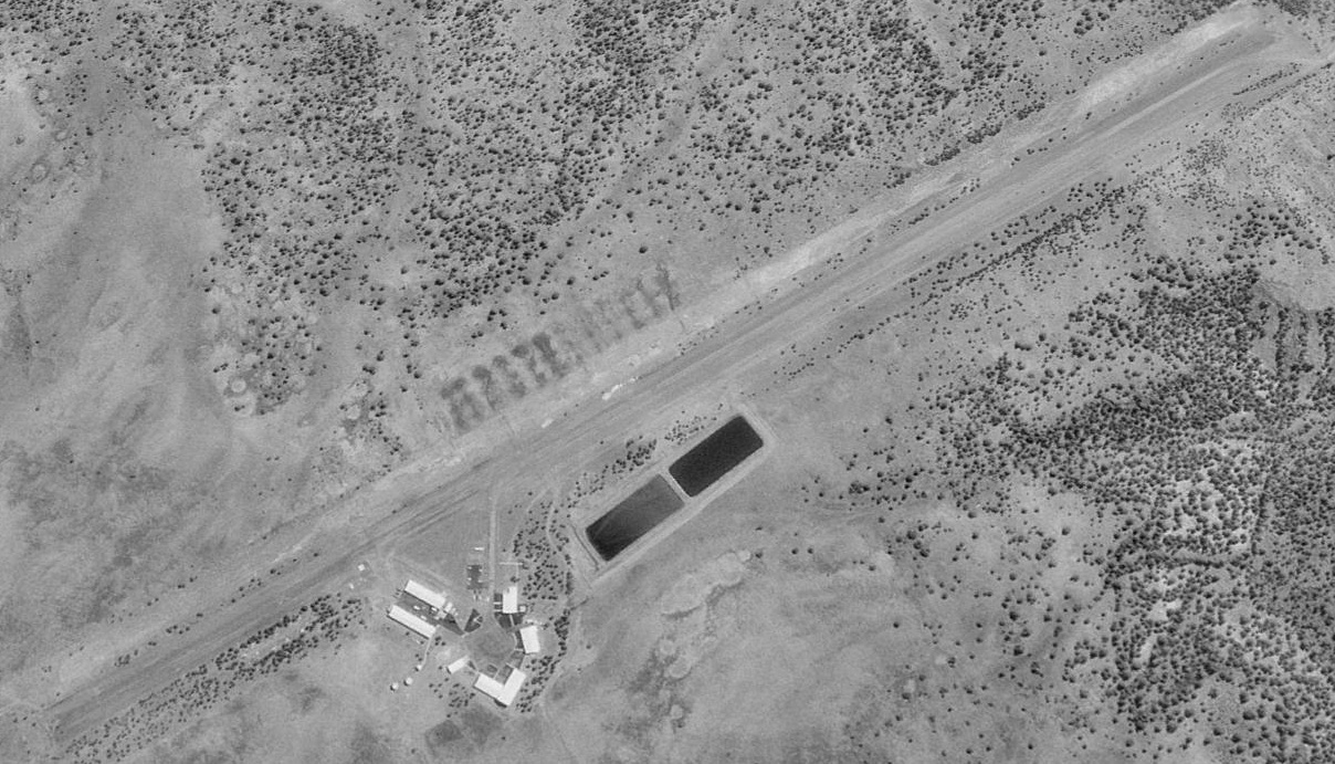
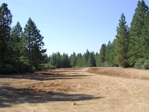
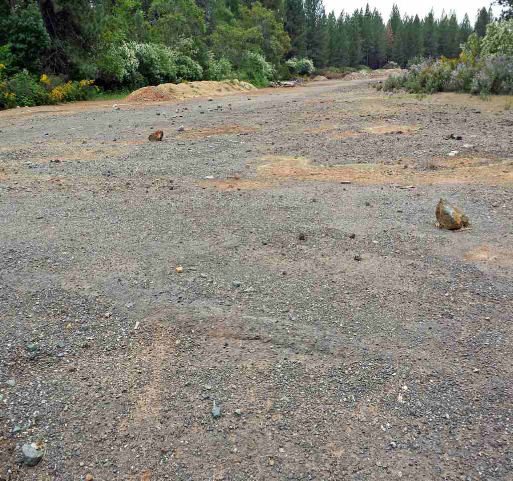
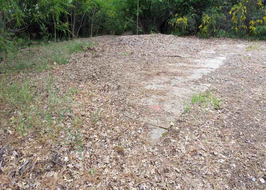
A 1981 aerial photo depicted the remains of the Secret Valley Intermediate Field runway, still recognizable.
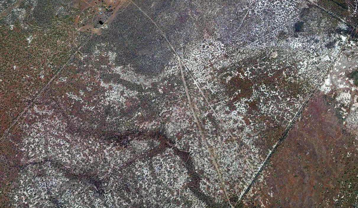
A 2019 aerial view looking northwest still showed the remains of the Secret Valley Intermediate Field runway, barely recognizable 70 years after being abandoned.
Thanks to Jonathan Westerling for pointing out this airfield.
____________________________________________________
Louisiana Pacific Mill Airfield, Burney, CA
41, -121.62 (Northeast of San Francisco, CA)
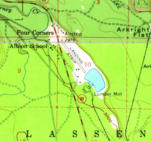
The Louisiana Pacific Mill Airfield was labeled simply as “Landing Strip” on the 1957 USGS topo map.
Not much is known about this evident private airfield, including its name or date of construction.
The Louisiana Pacific Mill Airfield was not depicted on the March 1955/58/65 Mt Shasta Sectional Charts.
Jody Hughes reported, “The Louisiana Pacific Mill airstrip... was a dirt runway used by the mill airplane for dusting the log decks for beetles during the summer.
Executives used to fly in there also. The plane used to fly all summer long over our houses. Part of why I'm a pilot now.”
The earliest depiction which has been located of the Louisiana Pacific Mill Airfield was on the 1957 USGS topo map,
which depicted a single northwest/southeast runway, labeled simply as “Landing Strip”, located northeast of the lumber mill.

The earliest photo which has been located of the Louisiana Pacific Mill Airfield was an 8/857 USGS aerial view,
which depicted a single northwest/southeast runway, with a small hangar on the southwest side.
Jody Hughes reported, “The last time it was used was the late 1980s or early 1990s when the mill was closed down.”
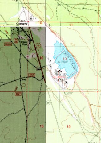
The 1990 USGS topo map no longer depicted the Louisiana Pacific Mill runway on the north side of the lumber mill.
The pond on the southeast side had been expanded at some point between 1957-90, covering the southeast portion of the runway.
In its place another runway had evidently been constructed on the south side of the lumber mill.
The northwest/southeast clearing for this runway was depicted, but not the runway itself.
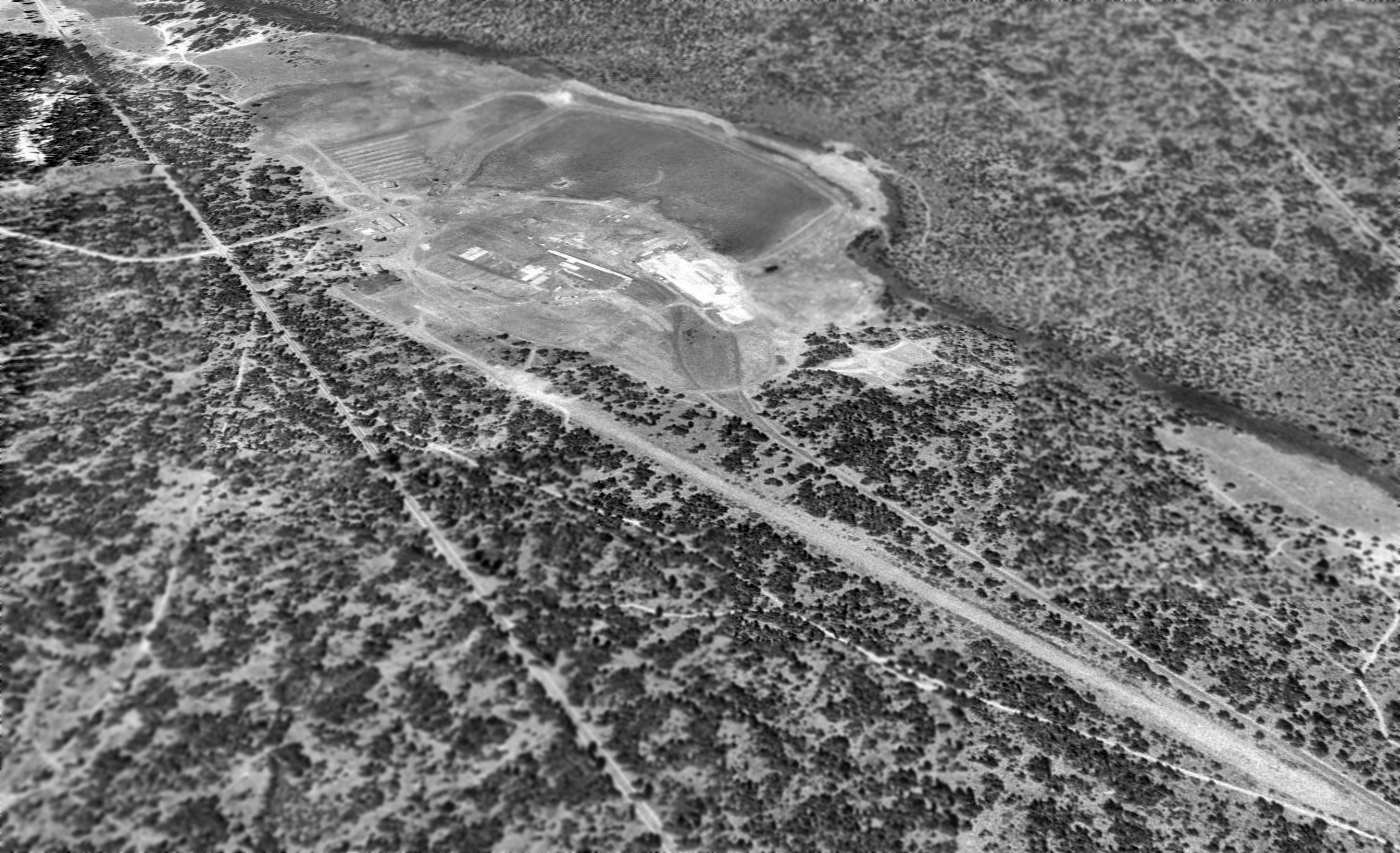
A 1993 USGS aerial view looking north showed the 2nd location of the Louisiana Pacific Mill Airfield runway, in the foreground.
The original location of the runway, on the north side of the lumber mill, was no longer evident at all.
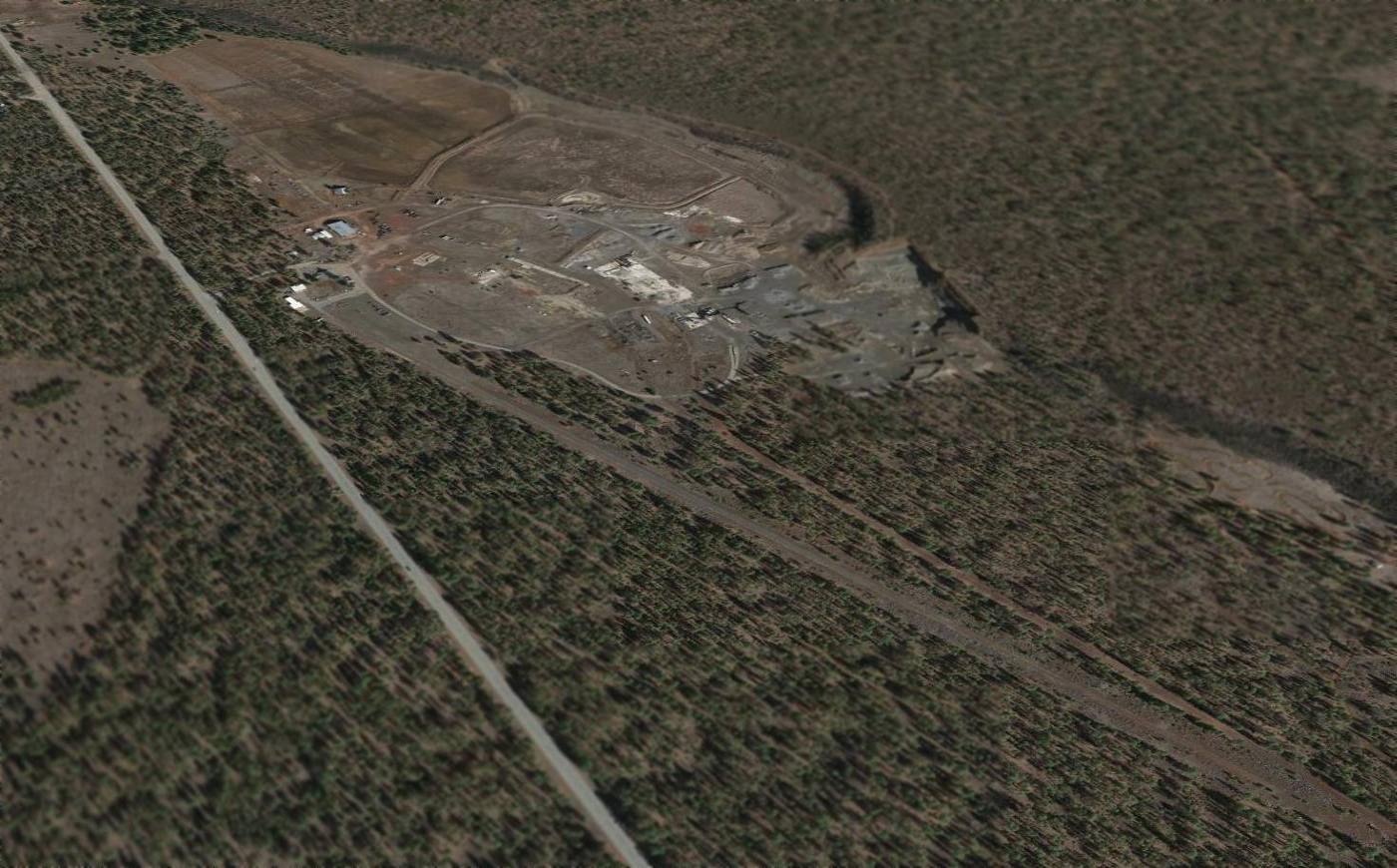
A 2014 aerial view looking north showed the runway of the 2nd location of the Louisiana Pacific Mill Airfield runway remained intact.
Jody Hughes reported in 2015 that “the Louisiana Pacific Mill site [is] now Hat Creek Construction. The runway is still there & may still be used.”
The site of the Louisiana Pacific Mill Airfield is located east of the intersection of Route 89 & Lorenz Road.
Thanks to Jody Hughes for pointing out this airfield.
____________________________________________________
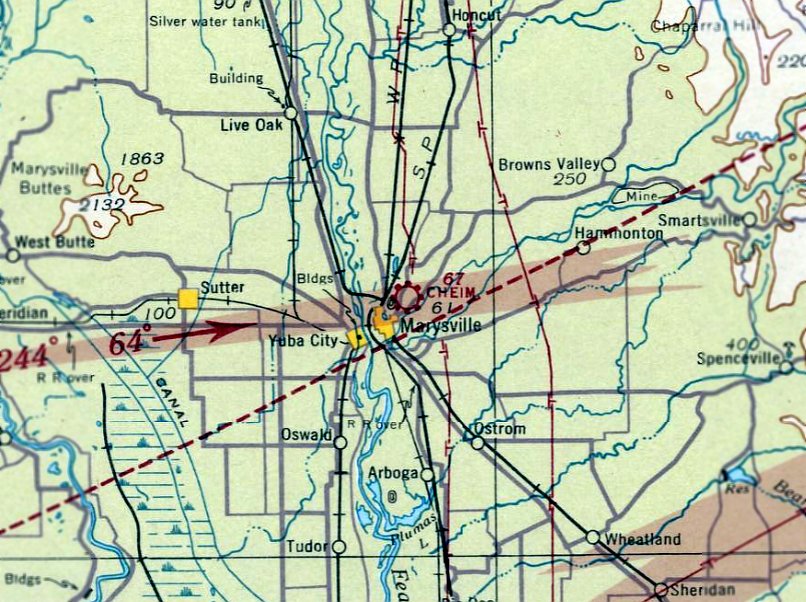
39.16 ,-121.57 (Northeast of San Francisco, CA)
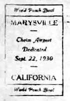
A postmark commemorating the 9/22/30 dedication of Cheim Airport.
The first airport for the town of Marysville was located adjacent to the east side of the town.
Cheim Airport was dedicated on 9/22/30, as commemorated by a postmark.
The earliest aeronautical chart depiction which has been located of Cheim Airport was on the May 1936 Sacramento Sectional Chart.
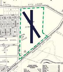
A 1939 street map depicted Cheim Airport as an irregularly-shaped property within which were 2 runways.
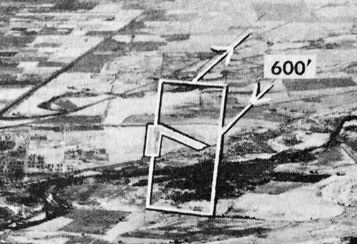
The earliest photo which has been located of Cheim Airport was a 1947 USGS aerial photo.
It depicted Cheim Airport as a very popular little general aviation airport
having 2 runways, with a few small buildings & no less than 25 light aircraft parked on the south side.
An undated aerial view looking north at Cheim Airport from the 1950 Air Photo Guide (courtesy of Kevin Walsh).
The guide described Cheim Airport as having 2 runways: 3,200' Runway 18/36 & 2,800' Runway 14/32.
It listed the manager as Sherman Perkins.
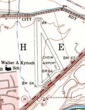
The last map depiction which has been located of Cheim Airport was on the 1952 USGS topo map,
which depicted it as having 2 runways & a few small buildings along the south side.
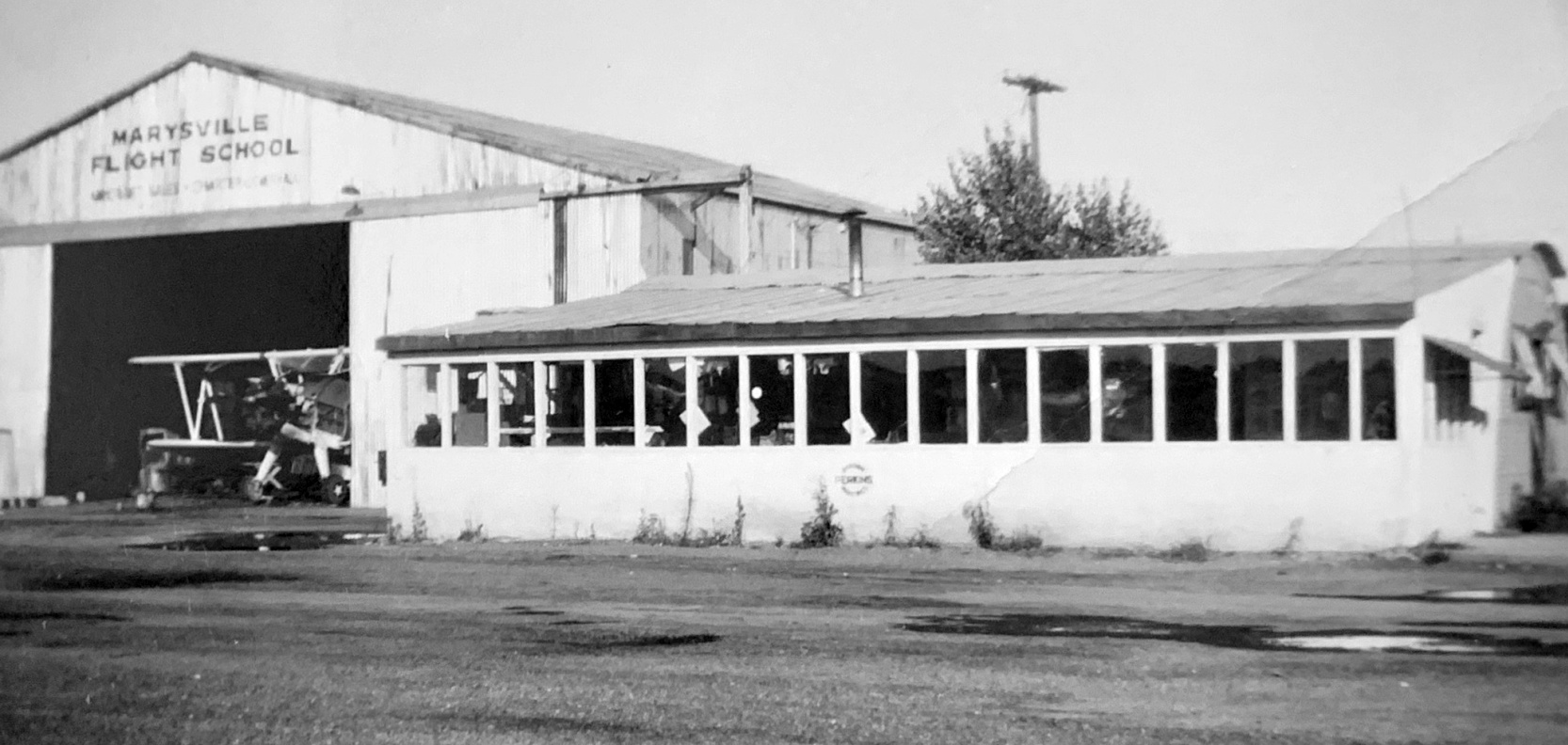
An undated photo of a biplane (model unidentified) inside the Marysville Flight School hangar at Cheim Airport (from the Grover Wing collection, courtesy of Gonzalo Curiel).
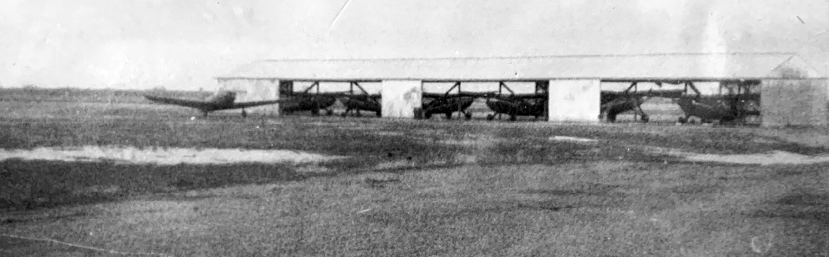
An undated photo of several light single-engine planes inside a hangar at Cheim Airport (from the Grover Wing collection, courtesy of Gonzalo Curiel).
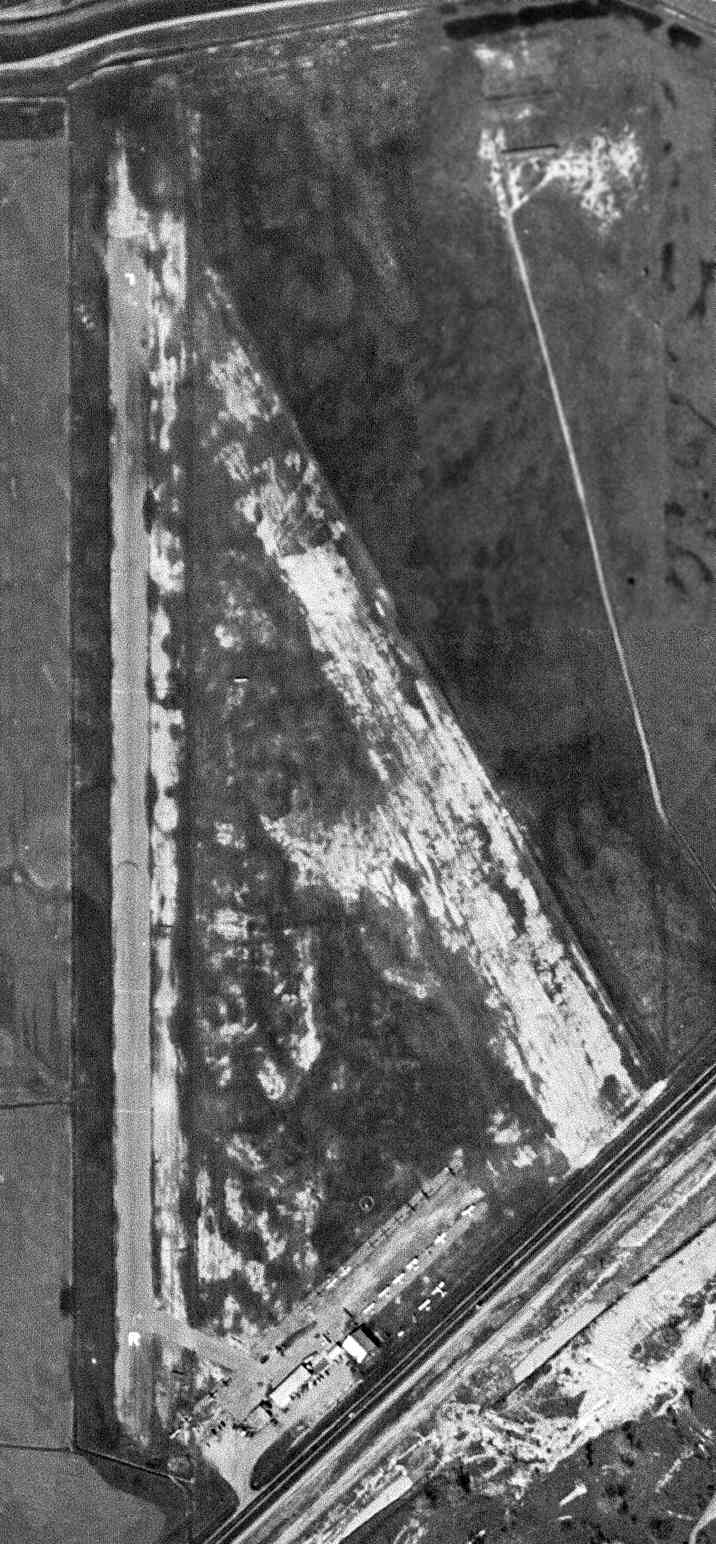
The last aerial photo which has been located of Cheim Airport was a 9/18/52 aerial photo.
In contrast to the 1947 photo, the number of aircraft visible at Cheim Airport had decreased drastically, to a small handful.
The last aeronautical chart depiction which has been located of Cheim Airport was on the September 1954 Sacramento Sectional Chart.
It depicted Cheim Airport as having a 3,400' paved runway.
Cheim Airport was evidently closed (for reasons unknown) at some point between 1954-55,
as it was no longer depicted on the March 1955 Sacramento Sectional Chart.
The 1973 USGS topo map showed that the site of Cheim Airport had been covered by residential streets.
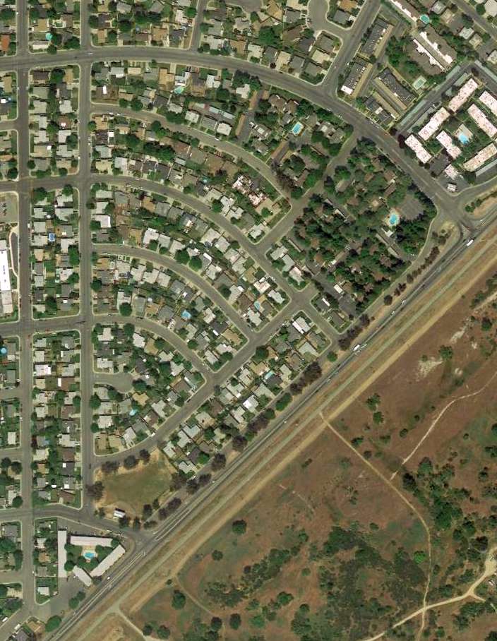
A 2013 aerial view showed no trace remaining of Cheim Airport.
The site of Cheim Airport is located northeast of the intersection of Leveee Road & East 17th Street.
Thanks to Michael McMurtrey for pointing out this airfield.
____________________________________________________
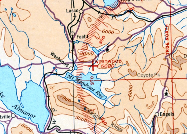
Westwood Airport (1st location), Westwood, CA
40.29, -120.99 (Northwest of San Francisco, CA)
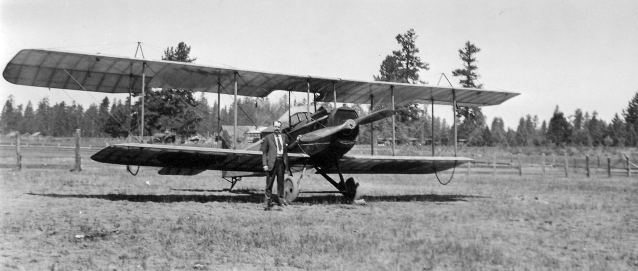
An 8/15/20 photo of an unidentified man & biplane (model unidentified) at Westwood Airport (courtesy of Sam Berliner).
Jonathan Westerling reported, “The modest community of Westwood had an airport since the early days of aviation.”
An airport on the east side of town operated from at least 1929 through at least 1938.
According to Tim Purdy, “Westwood’s aviation history is an obscure topic.
A crude landing field was established in the late 1910s on Mountain Meadows, about a mile south of the Goodrich Ranch.
Initially, its use was nominal, due to its poor condition. In one instance, Joe Hunter received a call from a pilot in Red Bluff about the current condition who replied that it is a mud bog & unfit for landing.”
Tim continued, “In the 1920s, Fletcher Walker’s 2 sons - Fletcher Jr., better known as 'Cub' & Kenneth - developed a strong interest in airplanes & became pilots.
This interest in flying gained momentum in the area, so that in June 1928 the Westwood Auto Club spent $100 to clear the landing field of brush & fill in holes
to make two 2,200' runways, thus the formal Westwood Airport was created - a first in Lassen County.
This caught the attention of Ted Campbell of San Francisco, manager of Beacon Airway, to examine the aviation field.
He made an inspection to examine the possibility of establishing regular air service to Reno & other points on the Transcontinental Airway route.
Yet, the prospect that Westwood residents would have nearby access to regular air service never materialized.”
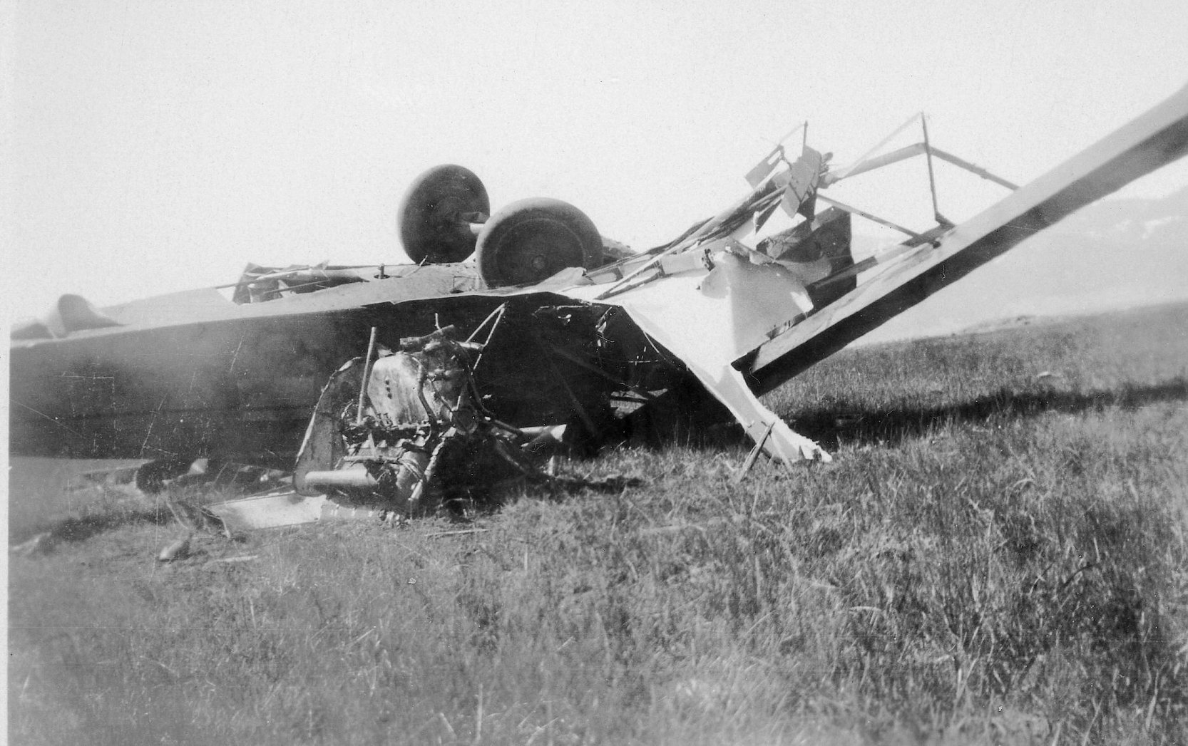
An August 1929 photo of the wreck of Fletcher & Kenneth Walker's biplane at Westwood Airport (courtesy of Sam Berliner).
According to Tim Purdy, “On 8/23/29, the worst aviation disaster occurred at the Westwood Airport’s brief history.
Cub & Kenneth routinely flew over Red River lands to photograph them. In this particular instance they were returning from such an expedition.
At approximately 6pm they were approaching the landing field when suddenly the plane malfunctioned & plunged crashing on impact.
Frank Stevenson & Mike Pappas witnessed the crash from afar as they were placing duck blinds on the far shore of Walker Lake.
The two men rushed to Westwood to inform the family & gather a party to go out to crash site.
Cub was instantly killed from a broken neck & the rescue party on their arrival found Kenneth regaining conscious & attempting to get out of the cockpit & later fully recovered.
The airport continued to see use in the early 1930s.”
The only aeronautical chart depiction which has been located of the original Westwood Airport was on the January 1935 Mt. Shasta Sectional Chart.
It depicted Westwood as an auxiliary airfield.
The last depiction which has been located of Westwood Airport was on the October 1936 Mt. Shasta Sectional Chart.
According to Tim Purdy, “By the end of the 1930s, Westwood Airport had become a footnote in Westwood’s history.”
Westwood Airport was evidently closed at some point between 1936-38,
as it was no longer depicted on the December 1938 Mt. Shasta Sectional Chart.
The original Westwood Airport was eventually replaced by a 2nd Westwood Airport, on the west side of town.
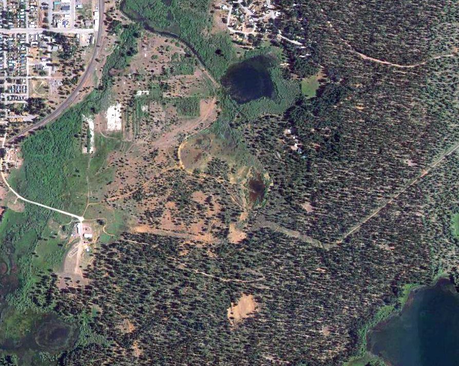
The precise location of the airport on the east side of Westwood has not been determined, but a 2017 aerial view shows no recognizable trace of a former airport.
____________________________________________________
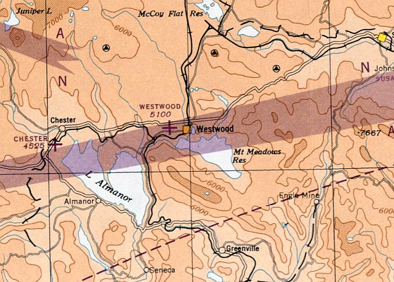
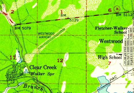
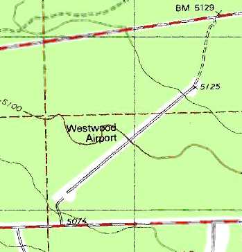
Westwood Airport (2nd location), Westwood, CA
40.31, -121.04 (Northwest of San Francisco, CA)
Westwood Airport, as depicted on the April 1947 Mt. Shasta Sectional Chart.
There was no airport near Westwood depicted on the December 1938 through October 1946 Mt. Shasta Sectional Charts.
At some point between 1946-47 an airfield was constructed on the west side of town, replacing the predecessor Westwood Airport on the east side.
The earliest depiction which has been located of the Westwood Airport on the west side of the town was on the April 1947 Mt. Shasta Sectional Chart.
It depicted Westwood as an auxiliary airfield.
The January 1948 Mt. Shasta Sectional Chart (courtesy of Chris Kennedy) depicted Westwood Airport as having a 3,900' unpaved runway.
The runway at Westwood was evidently somewhat shortened within the next few years,
as it was depicted as being only 3,100' on the 1948 Mt. Shasta Sectional Chart (courtesy of Jonathan Westerling).
The earliest photo which has been located of this Westwood Airport was a 1954 aerial view (from the UCSB Library, courtesy of Jonathan Westerling).
It depicted Westwood as having an unpaved northeast/southwest runway, with a ramp & a small building on the south side.
The 1956 USGS topo map depicted “Westwood Airport” as having a single northeast/southwest runway.
The Westwood Airport may have been closed at some point between 1956-62,
as there was no airport at Westwood depicted on the 1962 Mt. Shasta Sectional Chart (according to Jonathan Westerling).
The Westwood Airport was depicted on the 1964 USGS topo map.
Pat Duncan recalled, “In 1963 the Westwood Airport ('Westwood #2') was still active & being used by locals from the Westwood-Clear Creek areas.
It had significant use in that era during the summer July 'Paul Bunyan Days' celebration in Westwood.”
The Westwood Airport may have been reopened (with somewhat improved facilities) at some point between 1962-67,
as it was listed in the 1967 AOPA Airports Directory (according to Jonathan Westerling)
as having a 3,700' “seal coat” runway.
The last aeronautical chart depiction which has been located of the Westwood Airport
was on the 1969 Mt. Shasta Sectional Chart (courtesy of Jonathan Westerling).
It depicted Westwood as a public-use airport having a single 3,700' paved northeast/southwest runway.
Jonathan Westerling remarked, “The 1974 Flight Guide confirmed the airport as being unattended
with a hard surface Runway 3/21 as 3,700’.”
The Westwood Airport was still listed in the 1976 AOPA Airport Directory (according to Chris Kennedy).
Jonathan continued, “By 1978 however, the airfield was shortened then closed by the county.
The 1978 Pilot’s Guide to CA airfields lists Westwood’s Runway 3/21 being 3,160’
with the note 'AIRPORT CLOSED - Runway used for asphalt mixing'.”
Jonathan continued, “The airport was not listed in subsequent directories.”
By the time of the 1981 Mt. Shasta Sectional Chart (courtesy of Jonathan Westerling), Westwood was depicted as an abandoned airfield.
The 1989 USGS topo map depicted a single northeast/southwest runway, labeled simply as “Landing Strip”.
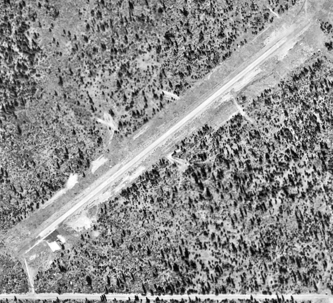
A 1993 USGS aerial view looking north at Westwood Airport showed the field as remaining intact, but without any obvious signs of recent use.
The 1995 USGS topo map depicted “Westwood Airport” as having a single northeast/southwest runway.
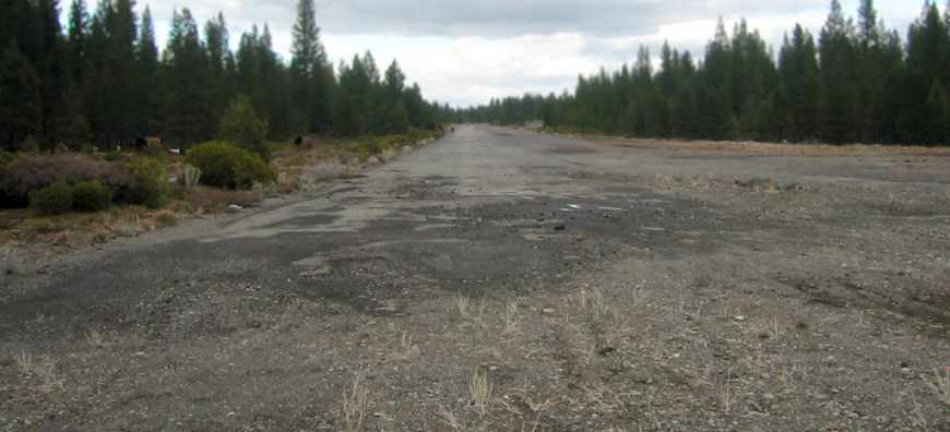
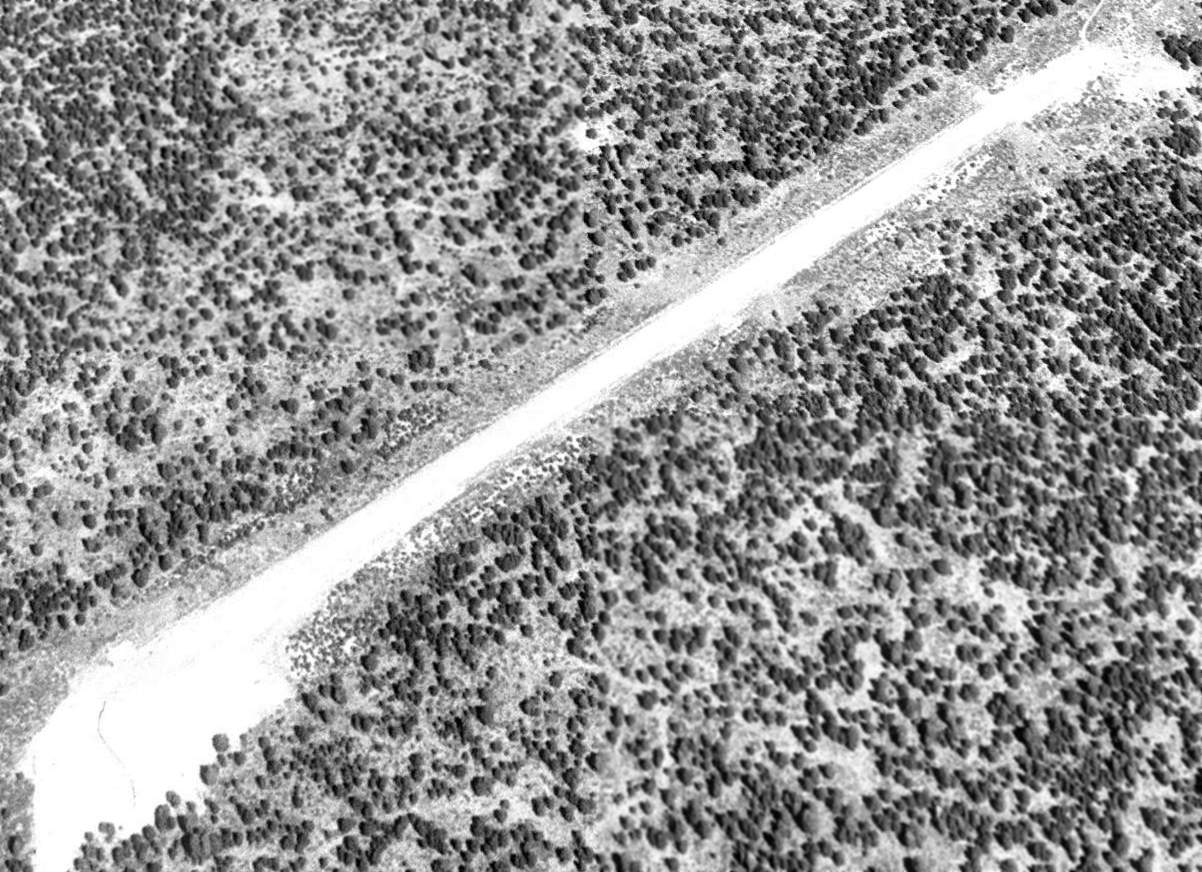
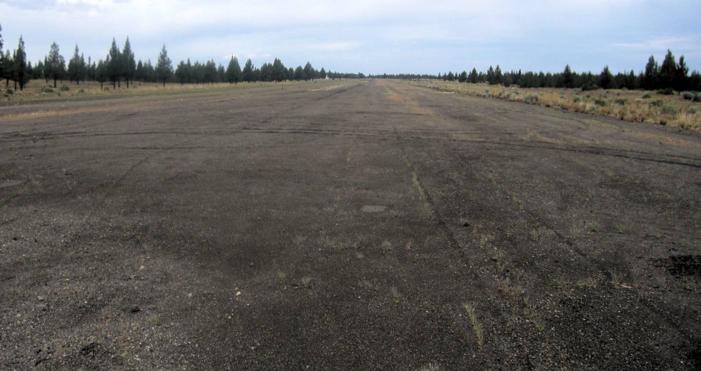
A 2007 photo by Jonathan Westerling looking north along Westwood's abandoned Runway 3.
Jonathan observed, “The pavement on the left is in relatively good condition.
Older pavement on the right side of the photo is more broken up. Each swath of pavement is about 50' wide.”
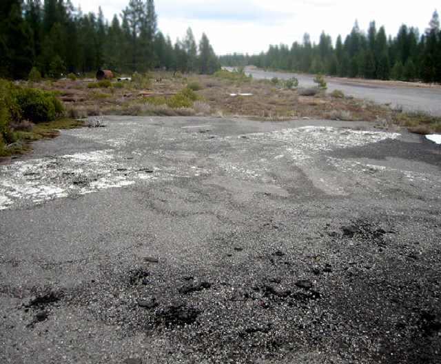
A 2007 photo by Jonathan Westerling, “An odd item on the location of the Westwood airfield,
is this X – normally placed ON the runway to symbolize its closure.
Here, however the X’s are painted on a separate bit of pavement just off the north side of the runway at each end.
There’s a good chance that with the larger Chester Airport just 8 miles west,
Lassen County did not perceive much value from maintaining an airstrip in Westwood,
though the airfield remains in good condition to this day.
Perhaps with the recent development of many vacation homes & golf courses on the Almanor Peninsula,
there will be a renewed interest in reviving a small local airfield here.”
Pat Duncan reported in 2016, “Westwood #2 is now used by Lassen County as a storage area for repair/repaving materials for county roads in that area.
The landing surface is still intact but not maintained.”
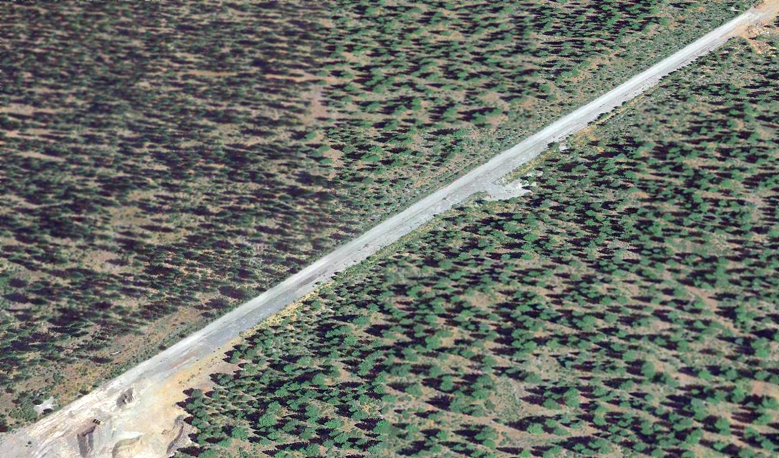
A 2017 aerial view looking north at Westwood Airport showed the field as remaining intact, but without any obvious signs of recent use.

A 2024 photo looking north at the Westwood Airport entrance gate.
The Westwood Airport is located southeast of the intersection of Routes 36 & 147.
Thanks to Jonathan Westerling for pointing out this airfield.
____________________________________________________
Chico Auxiliary Army Airfield #3 / Deer Creek Ranch Airport (CA60), Vina, CA
39.95, -121.99 (Northwest of San Francisco, CA)
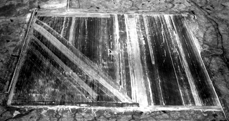
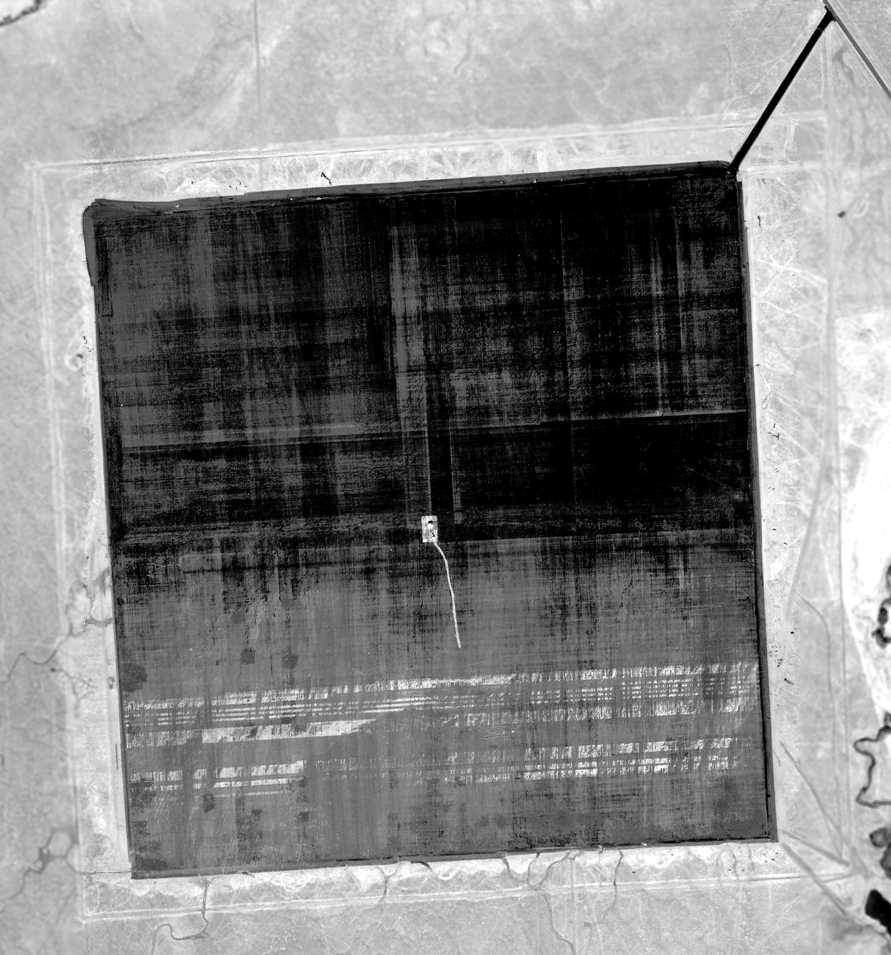
A 1/13/1943 U.S. Army aerial view looking north at the Chico Aux AAF #3 (from the National Archives, via Brian Rehwinkel).
This airfield was evidently built during WW2 as one of 5 satellite airfields used by Chico Army Airfield (11 miles to the southeast),
which was used to train fighter & bomber pilots.
The date of construction of this airfield is unknown.
It is presumed that it was not a pre-WW2 civilian airport, but rather was built by the military during the Second World War.
Chico AAF itself was used starting in 1942.
The earliest depiction which has been located of Chico Aux AAF #3
was a 1/13/1943 U.S. Army aerial view looking north (from the National Archives, via Brian Rehwinkel).
A total of 13 single-engine aircraft were seen on the field.
It depicted the field as consisting of a rectangular paved “landing mat”.
The rectangular shape of the mats permitted aircraft to land in any direction, eliminating the possibility of a crosswind.
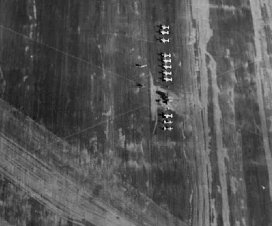
A closeup from the 1/13/1943 U.S. Army aerial view (from the National Archives, via Brian Rehwinkel),
showing a total of 13 unidentified single-engine aircraft parked on the center of Chico Aux AAF #3.

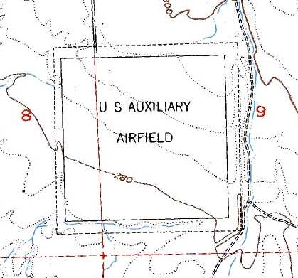
The 1944 USGS topo map (courtesy of Chris Kennedy) depicted the square landing mat, labeled as "US Auxiliary Airfield".
Strangely, Chico Aux AAF #3 was not depicted at all on the 1943/44/48/49 Sacramento Sectional Charts.
The parent airfield, Chico AAF, was described as “Inactive” in the 1945 AAF Airfield Directory (courtesy of Scott Murdock),
so military use of Chico Aux #3 had most likely ended by that point.
The earliest aeronautical chart depiction which has been located of Chico Auxiliary #3 was on the March 1950 Mt Shasta Sectional Chart.
It depicted "Chico Aux #3" as a civilian airfield having a 3,000' paved runway.
The last aeronautical chart depiction which has been located of Chico Auxiliary #3 was on the September 1957 Sacramento Sectional Chart (courtesy of Chris Kennedy).
It depicted "Chico Aux #3" as a civilian airfield having a 3,000' paved runway.
Chico Auxiliary #3 was evidently abandoned at some point between 1957-58,
as it was no longer depicted on the April 1958 Mt Shasta Sectional Chart.
David Anderson recalled, “I have been on the actual surface of Chico Aux #3 many times,
as a portion of it was utilized as a dragstrip during the time period 1963-66.
Bob Foor obtained permission to operate a drag strip which was called Vina Raceway
from either the owner of the land or the County Board of Supervisors.
Mike Pelak ran the operation.
The asphalt surface was deteriorating, as no maintenance had been done since it was built apparently during WWII,
but portions of it were good enough to use for racing purposes.
Metal guard rails were installed like you would find at the side of roads back in the 1970s.
They were probably removed as part of the demise of the track operation.
The strip utilized an area about in the middle of the expanse of asphalt, running North to South.”
The 1969 USGS topo map depicted the 3,100' square landing mat, labeled as "US Auxiliary Airfield",
The 1980 USGS topo map also still depicted the landing mat, labeled as "US Auxiliary Airfield".
The 1998 USGS aerial photo showed that 2 small buildings (presumably of post-WW2 civilian construction) were on the northeast corner of the landing mat.
No trace was perceptible of the 1960s drag racing use of the landing mat.
It was still listed in the 2003 Airport Facility Directory as a private airfield, the Deer Creek Ranch Airport,
although it was not depicted at all on the 2003 Sectional Chart.
According to the 2003 Airport/Facility Directory, one single-engine airplane is based at the field.
The "Vina Mat" is listed as a reporting point on approach charts for Chico Airport, according to Don Howell.
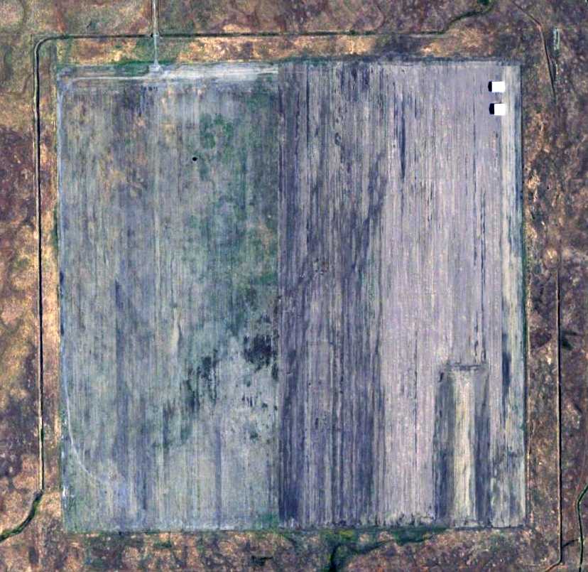
The 8/29/06 USGS aerial photo showed the field remained in the same condition,
with the landing mat remaining intact, and 2 small buildings on the northeast corner.
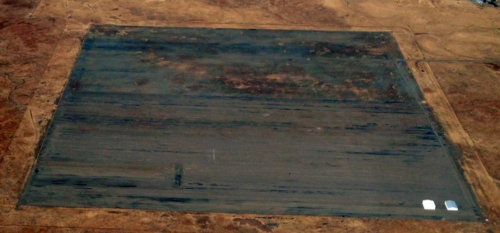
A 2007 panoramic shot of the Vina landing mat by Jonathan Westerling, showing the 2 buildings on the mat.
Jonathan reported, “From a distance it looks like the asphalt is untouched
and has some piles of farming debris & a lot of grass growing up from the cracks in it.
Calls to the number listed in the FAA airport directory came up as a wrong number.
I understand that the owner of the parcel used to be a pilot & would fly in on occasion, but he’s getting on in age and doesn’t do that any more.
I'm not sure what will happen to this, one of the last intact WWII landing mats in the USA when he decides to sell his land.”
A 9/5/15 aerial view by Gonzalo (Peewee) Curiel looking west showed the Vina landing mat remained intact, with 2 small buildings on the northeast corner.

A 2023 photo looking southeast at the 2 buildings on the northeast side of the Vina landing mat.
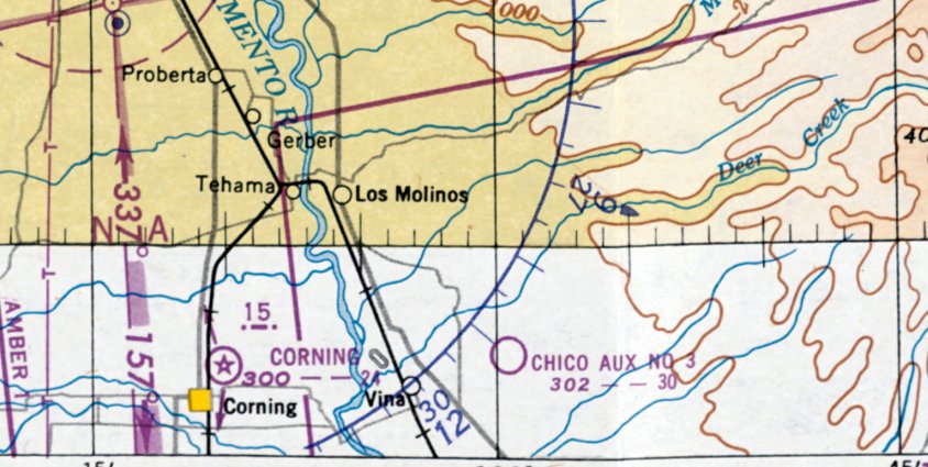
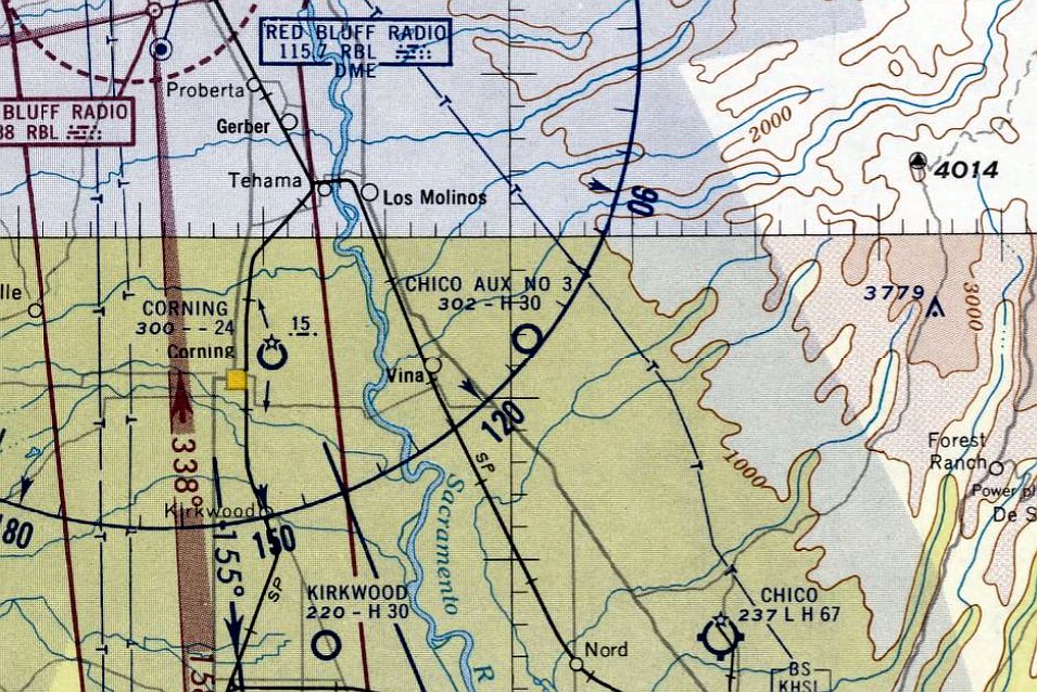
The site of the Vina airfield is located southeast of the intersection of Reed Orchard Road & Leininger Road, 3 miles east of the town of Vina.
Thanks to Ken Couche for pointing out this airfield.
____________________________________________________
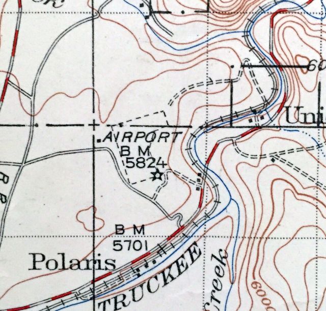
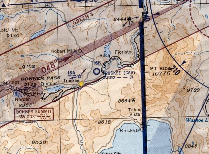
Truckee Intermediate Field, Truckee, CA
39.36, -120.13 (Northeast of Sacramento, CA)
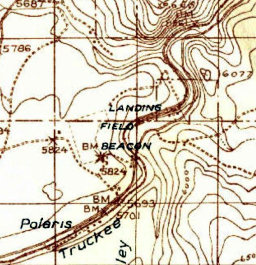
Truckee Intermediate Field, as depicted on the 1932 USGS topo map (courtesy of Kevin Walsh).
The original airport for the town of Truckee was located to the northeast of the town.
Truckee Intermediate Field was constructed as one of the Department of Commerce's network of Intermediate Fields,
which were established for the emergency use of commercial aircraft flying along airways between major cities.
The date of construction of the Truckee Intermediate Field has not been determined.
The earliest depiction which has been located of Truckee Field was on the 1932 USGS topo map (courtesy of Kevin Walsh).
It depicted an irregularly-shaped property outline, generically labeled “Landing Field”, with a beacon at the southeast corner.
The earliest airport directory listing which has been located of Truckee Field was in The Airport Directory Company's 1933 Airport Directory (courtesy of Chris Kennedy).
It described Truckee as the Department of Commerce's Site 16B along the San Francisco – Salt Lake Airway.
The field was said to consist of an 113 acre, decomposed rock field, containing 2 runways in an L-shape, measuring 2,858' & 2,575'.
The field was illuminated, but offered no services.
The earliest aeronautical chart depiction which has been located of Truckee Field was on the May 1936 Sacramento Sectional Chart.
It depicted Truckee as Site 16B.
The Airport Directory Company's 1938 Airport Directory (courtesy of Chris Kennedy)
also described Truckee as Commerce Department's Site 16B along the San Francisco – Salt Lake Airway.
The field was said to have 3 runways, with the longest being the 3,400' northeast/southwest strip.
A shed was said to be marked with “16B SF-SL” on its roof. The field was illuminated, but offered no services.
The 1940 USGS topo map (courtesy of Kevin Walsh) depicted Truckee Field as an irregularly-shaped property outline, generically labeled “Airport”, with a beacon at the southeast corner.
The April 1942 6M Regional Aeronautical Chart (courtesy of Chris Kennedy) depicted Truckee as Site 16B.
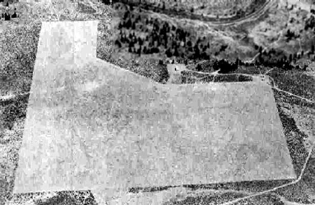
The earliest photo which has been located of the Truckee Intermediate Field
was an 8/11/43 aerial view looking east from the 1945 AAF Airfield Directory (courtesy of Scott Murdock).
It depicted Truckee as an L-shaped unpaved area.
The 1945 AAF Airfield Directory (courtesy of Scott Murdock) described Truckee Intermediate Field
as a 116 acre L-shaped property containing a sand & gravel all-way field, measuring 3,400' northeast/southwest.
The field was said to have a single 50' x 36' wood hangar,
to be owned by private interests, and operated by the Civil Aeronautics Administration.
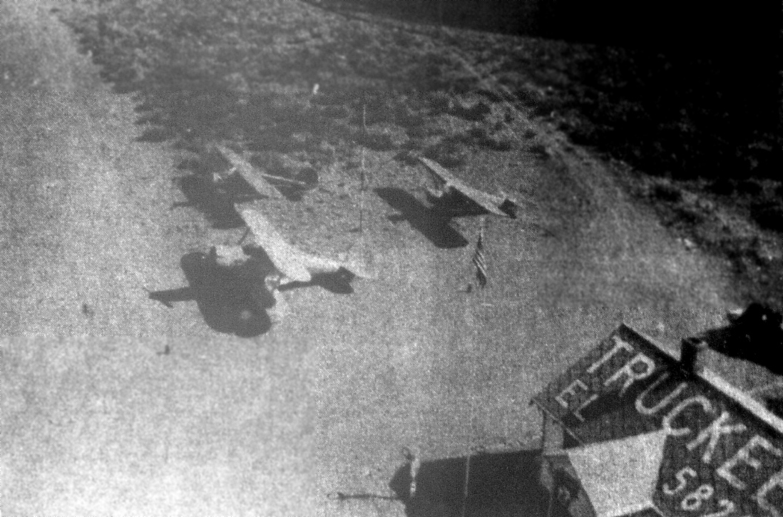
A circa 1940s aerial view of Truckee Intermediate Field (courtesy of Heidi Sproat) depicted a Beech Staggerwing & 2 other light single-engine taildraggers next to the airport office building,
which had “Truckee” & the field elevation painted on its roof.
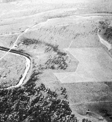
The last dated photo which has been located of the Truckee Intermediate Field was a 1952 aerial view (from the UCSB Library, courtesy of Jonathan Westerling).
Paradoxically, it showed 2 closed-runway “X” symbols on Truckee's airfield, but 2 light single-engine aircraft were visible near a few small buildings on the southeast corner.
An undated aerial view of Truckee Intermediate Field from a 1953 book (courtesy of Jonathan Westerling).
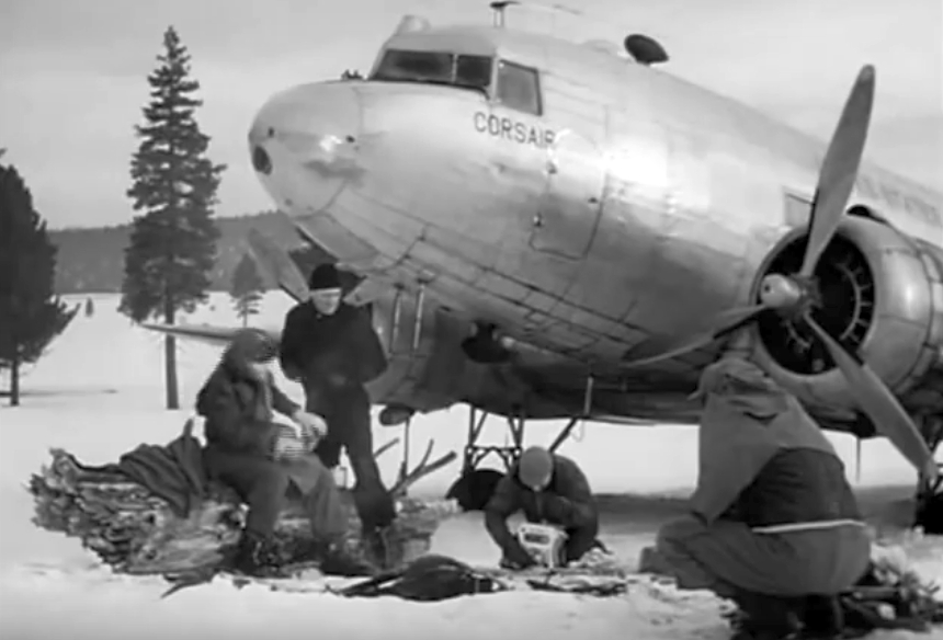
A still of the Douglas C-47 “Corsair” from the 1953 John Wayne movie “Island In the Sky”, filmed at Truckee Intermediate Field.
According to the Truckee-Donner Historical Society (courtesy of Marylin Samuel),
“In 1953, the filming of the John Wayne classic, 'Island in the Sky' created a lot of excitement in town.
The film was about an Air Force transport [C-47] forced down on the bleak wastes of Labrador
and the efforts of a rescue squadron to locate the plane in the frozen desolate area.
Most of the filming was done at the old Truckee airstrip.
The film co-starred Lloyd Nolan & Ward Bond. More than 100 actors & technicians were in town during the filming.
Nelson Stone, a longtime Truckee resident, was hired as a technician & worked on the set at the old airstrip.
Stone believed that the title for 'Island in the Sky' was inspired by the deep fog bank that often appears in the morning at the base of Boca Hill.
On certain days the layer of fog creates an illusion that makes the top of the Boca hill look like a beautiful mountain island suspended in the sky.”
The March 1954 Sacramento Sectional Chart (courtesy of Chris Kennedy) depicted “Truckee (CAA)” as having a 3,400' unpaved runway.
Truckee Intermediate Field was evidently abandoned at some point in 1954,
as it was no longer depicted on the March 1954 Sacramento Sectional Chart.
It was eventually replaced by the Truckee-Tahoe Airport, a mile to the south.
The last depiction which has been located of the Truckee Airport was on the 1955 USGS topo map (courtesy of Chris Kennedy).
A 1962 aerial photo (according to Jonathan Westerling) showed “that improvements had been made to the field” compared to its depiction in 1952.
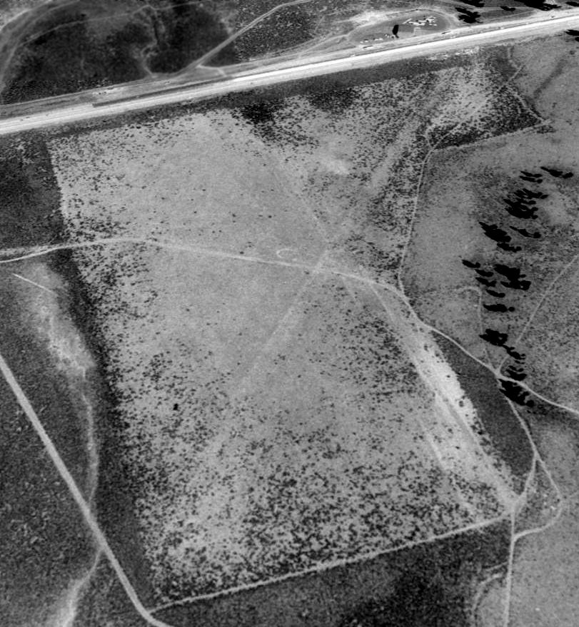
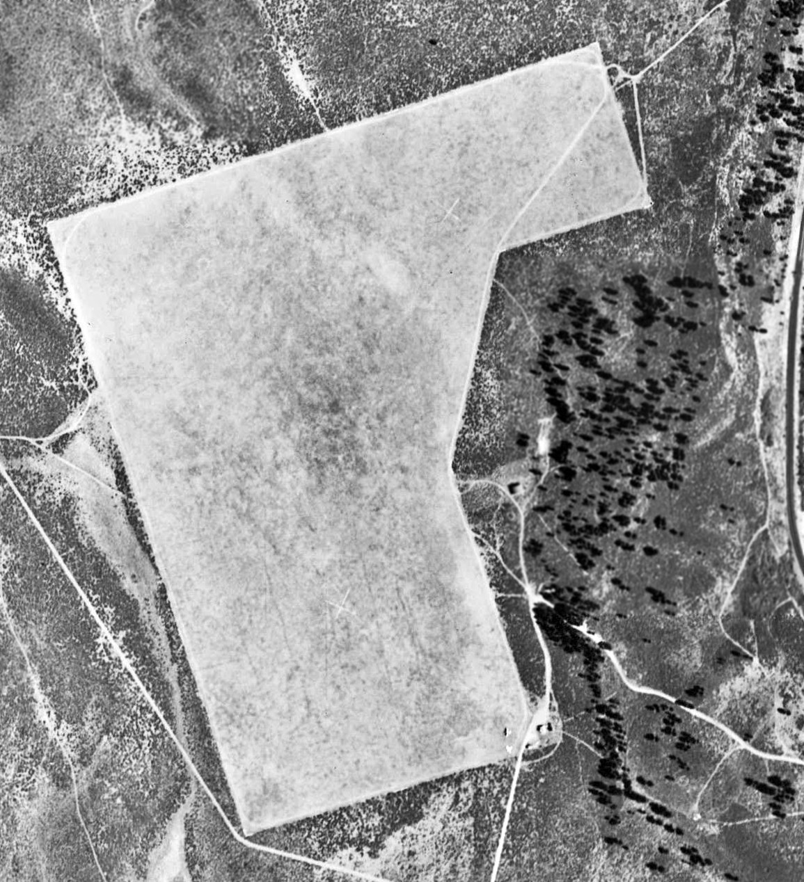
A 1992 USGS aerial view looking north showed the outline of the Truckee Intermediate Field remained recognizable, along with 2 runways within the airfield,
and the remains of the airfield circle marking to the west of the runway intersection.
There was no sign of any remains of any buildings at the airfield.
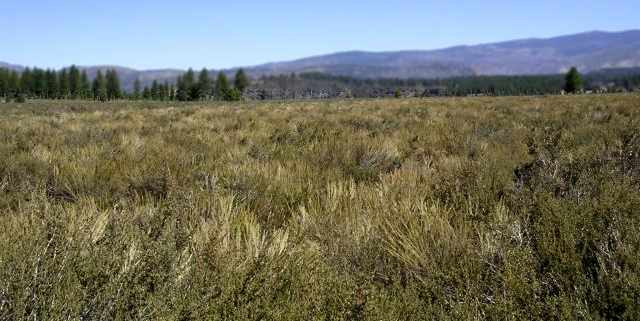
A 2005 photo by Dann Shively, looking southeast along the site of the former Truckee Intermediate Field.
Dann reported: “I couldn't find anyone at the current [Truckee] Airport who knew anything about pictures of the original site.
So I ventured out to see what it looked like on the ground. Aerial photographs in two dimension can be misleading.
From the air the whole area looks pretty flat.
But I found out the whole 'Airport Flats' area is actually a large plateau area above the river & old road nearby.
I completely missed the turnoff and was on my way to Reno before realizing I'd probably missed it.
So back onto westbound Interstate 80 I went & took a turnoff that looked like it might lead me there.
After turning under the freeway I came to Old Truckee Airport Road.
Unfortunately it became this horrible dirt & rock road after only a half mile.
The road was horrible. I should have had a Jeep or a motorcycle... not a Toyota Celica.
I proceeded very slowly looking for any trace of anything. Although, from the air you can make out the old runways,
from the ground there is nothing but three-foot-tall sagebrush as far as the eye can see.
And I wasn't about to walk through it! I can't communicate enough how desolate it is out there.
I did notice some survey stakes & ribbons so maybe someone is planning something. Otherwise all it's home to now are rabbits & snakes.”
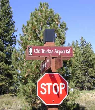
A 2005 photo by Dann Shively of a sign for “Old Truckee Airport Road”.
Dann reported, “It's a newer sign off I-80 to the west of the airport site where there's a private golf course community.”
Unfortunately, Chris Kennedy reported “The Truckee Town Council on 5/4/06 voted to change the name of 'Old Truckee Airport Road' to 'Overland Trail'.
One more piece of airport history lost.”
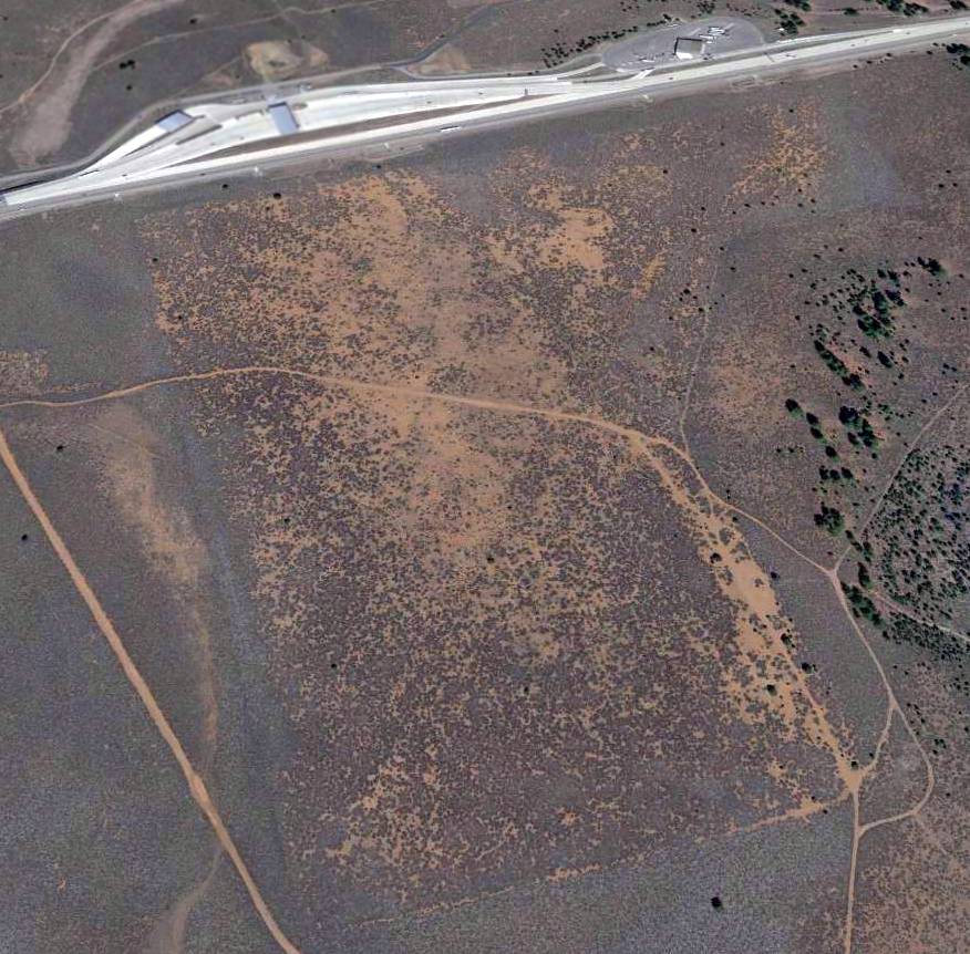
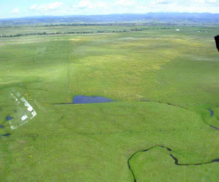
A 2015 aerial view looking north showed the outline of the Truckee Intermediate Field remained intact, more than 50 years after being abandoned.
The site of Truckee Intermediate Field is located at the eastern terminus of Overland Trail, southeast of Interstate 80.
____________________________________________________
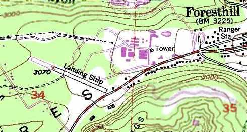
Foresthill Airport, Foresthill, CA
39.02, -120.84 (Northeast of Sacramento, CA)
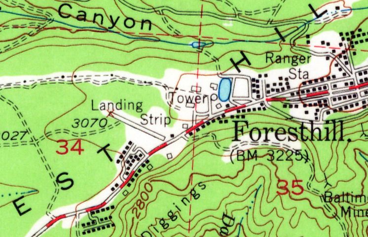
The Foresthill Airport, as depicted on the 1950 USGS topo map.
The date of construction of the Foresthill Airport has not been determined.
The earliest depiction which has been located of Foresthill Airport was on the 1950 USGS topo map.
It depicted a single 2,300' northwest/southeast runway, labeled simply as "Landing Strip".
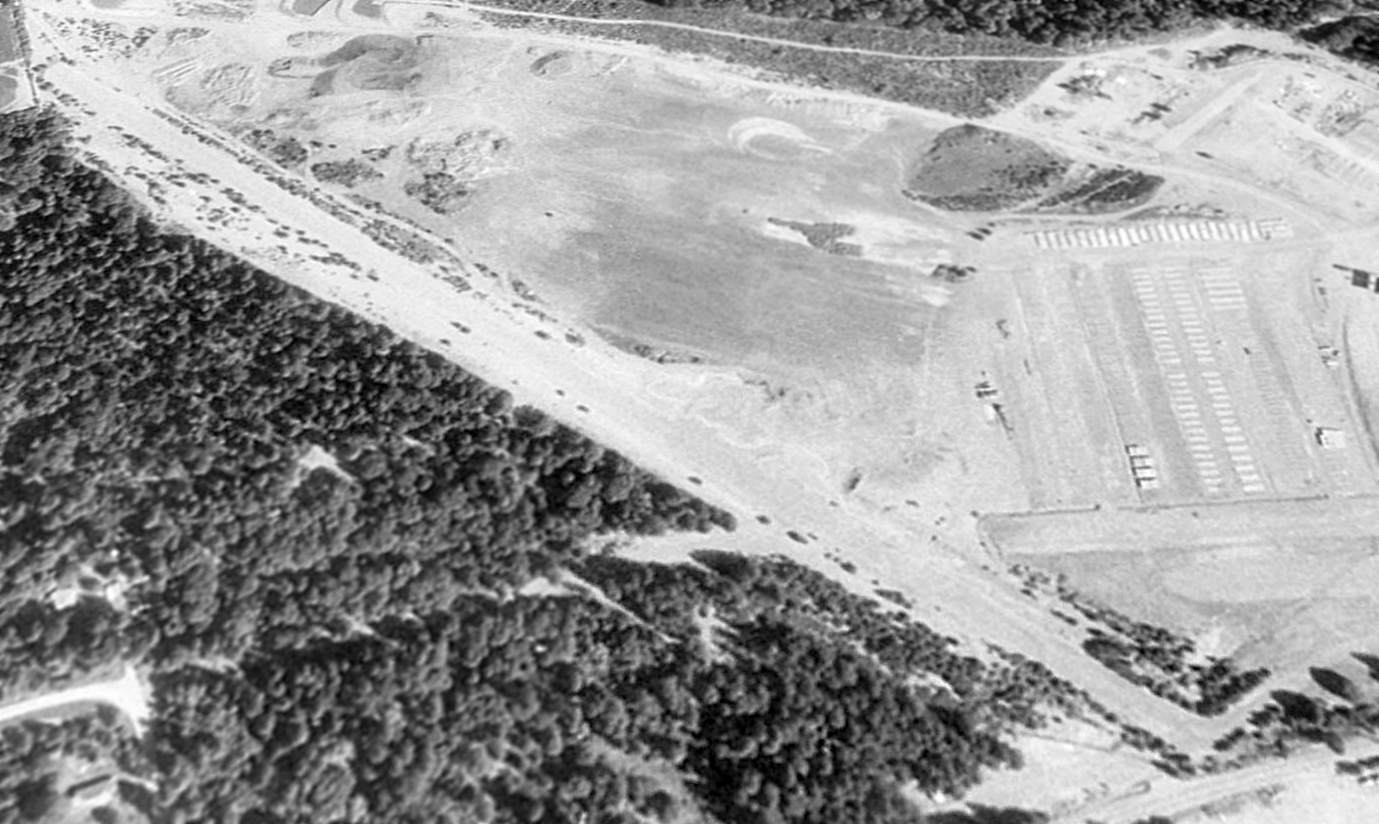
The earliest photo which has been located of Foresthill Airport was a 7/20/52 USGS aerial view.
It depicted a single northwest/southeast unpaved runway, with a large number of items stored on either side of the southeast runway end.
There did not appear to be any hangars or aircraft on the field.
Foresthill Airport was not depicted at all on the 1961 Sectional Chart (according to Dann Shively),
listed in the 1963 AOPA Airport Directory (according to Chris Kennedy),
or depicted on the June 1966 Sacramento Sectional Chart (according to Chris Kennedy).
The 1973 USGS topo map continued to depicted Foresthill Airport as a single 2,300' runway, labeled simply as "Landing Strip".
Foresthill Airport was also depicted the same way on the 1977 USGS topo map.
No airfield at this location was depicted on the November 1976 San Francisco Sectional Chart (according to Chris Kennedy),
or listed in the 1980 or 1982 AOPA Airports USA Directory (according to Chris Kennedy).
Dann Shively reported, “Foresthill is a tiny community in the mountains about 40 miles northeast of Sacramento.
There were several sawmills operating in the area for years.
One of these had several owners, the last of which was Georgia Pacific.
On the west side of the property was an unpaved airstrip. It was mostly used for company aircraft.
But it was also used as an emergency field for local med-evac flights.
I landed there a couple of times back in the 1970s & 1980s in connection with news stories we were doing in the area.
I had no problem landing a Cessna Cardinal there and the company's twin-engine planes landed there regularly.
The runway was certainly long & wide enough for that, even with the trees so close.”
The Foresthill Airport was presumably closed at some point before 1984,
as it was not depicted at all on the 1984 Sectional Chart (according to Dann Shively).
According to Dann Shively, “The sawmill closed in 1993. Possibly the strip went unused for years before that.”
A 1993 USGS aerial view looking north showed the Foresthill Airport runway remained intact, but showed no sign of active use,
According to Dann Shively, “After about 10 years of inactivity [in 2003], the mill property started to be developed.
Much of it is home to the new Foresthill High School, some of which is still under construction.
There are plans to use some of the property for commercial development as well.”
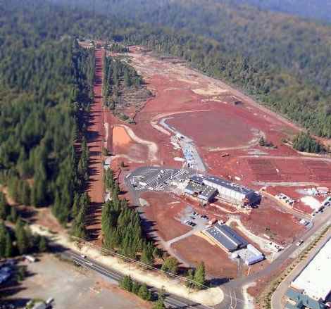
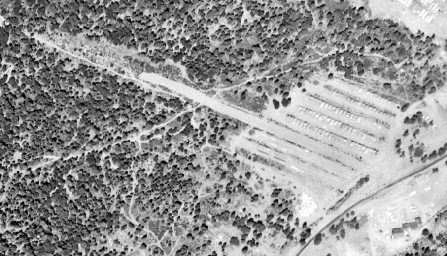
A 2005 aerial photo by Dann Shively, looking northwest along the Foresthill runway, with the former sawmills on the right.
Dan reported, “The main layout of the airstrip is still intact, running northwest/southeast.
I think the trees right on the edge on the west side of the strip have grown there in recent years.
There were always trees on the west side but they weren't THAT close.
You can see in the aerial shots the trees right beside the strip on both sides are about the same age.
The ones slightly to the west are bigger. There was more room when the strip was being used.
You can also see a delineation in the row of trees on the west side.
Maybe those trees were purposely planted to keep people from landing there?”
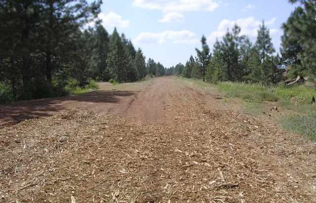
A 2005 photo by Dann Shively, looking northwest along the abandoned Foresthill runway.
Dan reported, “After so many years of inactivity the surface is a bit rough; but not as bad as you'd think.
It looks as though a few passes with some heavy equipment would make it usable again, except, of course, for some of those trees.
There were always high trees on the west side but the ones on the east side weren't there when it was in operation.
I don't know if there are any plans to ever use the airstrip again although in the current climate I would doubt it.”
A 2015 aerial view looking north showed the Foresthill Airport runway remained recognizable.
Foresthill Airport is located northwest of the intersection of Foresthill Divide Road & Sunset Drive.
____________________________________________________
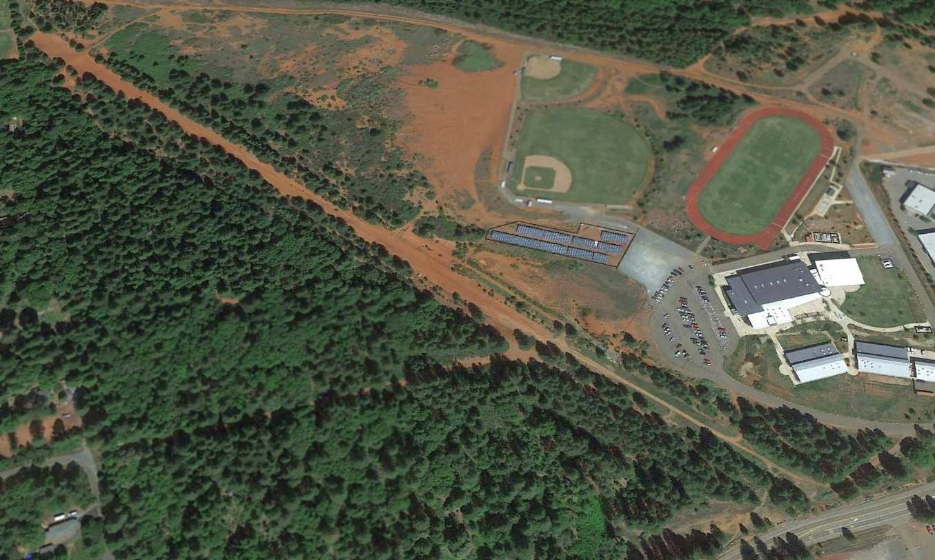
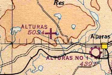
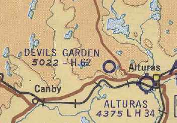
Alturas #2 Airport / Devil's Garden Airport, Alturas, CA
41.524, -120.669 (Northeast of Sacramento, CA)
“Alturas Municipal Airport (New)”, as depicted in the 1945 AAF Airfield Directory (courtesy of Scott Murdock).
According to the California Department of Forestry (courtesy of Chris Kennedy),
in the spring of 1942 the Civil Aeronautics Administration began formal surveys of this site
with plans to construct an airfield to accommodate both commercial & military aircraft.
No airfield at the location was yet depicted on the April 1944 Mt. Shasta Sectional Chart (according to Chris Kennedy).
Construction & paving of the 6,250' runway did not begin, however, until late in 1944.
Although the California Department of Forestry's history of the site
states that the airport project was "abandoned in 1945", that is obviously incorrect,
as it was depicted as an active airfield on numerous aeronautical charts over the next 2 decades.
The earliest depiction which has been located of this airfield was in the 1945 AAF Airfield Directory (courtesy of Scott Murdock).
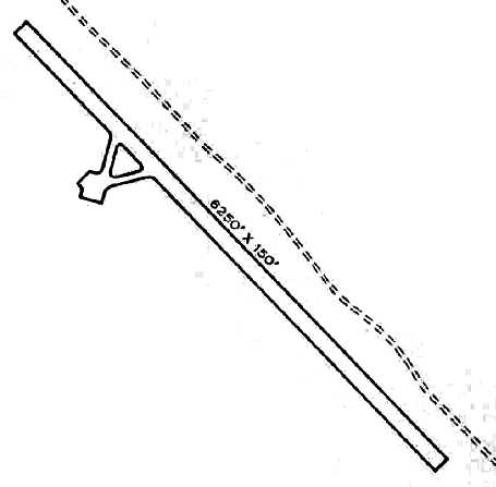
It described the “Alturas Municipal Airport (New)” as a 4,000 acre (!) property containing a single 6,250' concrete northwest/southeast runway.
The diagram depicted a ramp on the west side, but no buildings were depicted or described in the listing.
The field was said to be owned by the City of Alturas.
The earliest aeronautical chart depiction of the airfield which has been located was on the October 1946 Mt. Shasta Sectional Chart (courtesy of Chris Kennedy).
It depicted this field as an auxiliary airfield, labeled simply as "Alturas", along with the original Alturas Municipal Airport, labeled "Alturas #1", a few miles to the southeast.
The earliest photo which has been located of this Alturas Airport was a 1946 aerial view (courtesy of Pamela Bumstead).
It depicted Alturas as having a single paved northwest/southeast runway, with paved taxiways leading to a paved ramp on the northwest side.
According to Pamela Bumstead, “This would have been after the transfer to Forest Service.”
The November 1948 Mt. Shasta Sectional Chart (courtesy of Chris Kennedy) depicted this field as "Alturas (New)",
and described the field as having a 6,300' hard-surface runway.
The September 1954 USAF Mt. Shasta Sectional Chart (courtesy of Chris Kennedy) labeled the field once again simply as "Alturas".
A 1955 aerial view (courtesy of Jonathan Westerling) depicted Alturas Airport as having a single paved northwest/southeast runway.
In 1960 the U.S. Forest Service proposed upgrading the airport to serve as an air base to fight fires.
Two former Navy torpedo bombers (modified for firefighting) were permanently based at the airport.
During the height of the fire season, as many as six aircraft with crews remained on alert at the airfield,
and it became a well-known landing spot for many aviators.
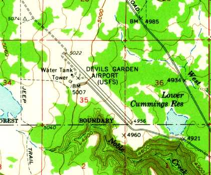
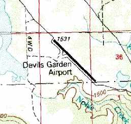
The 1962 USGS topo map depicted the “Devils Garden Airport (USFS)”.
The 1962 Sectional Chart (courtesy of Jonathan Westerling) labeled the field as "Alturas #2", but indicated it was closed.
The December 1963 USAF Crater Lake Operational Navigation Chart (courtesy of Chris Kennedy) labeled the field as "Alturas #2".
Pat Duncan recalled, “I started my career in 1962 as a helicopter mechanic for a company that had USFS helitac 3 year contracts on the Lassen & other northeast CA National Forests.
We flew Bell G3-B1s on all contracts. In 1965 I was based at Devils Garden Airport.
That year, in addition to our G3-B1, there was PBY Catalina based there as well that was owned & operated by Liston Flying Service, Lakeview OR.”
At some point between 1963-66, the field was renamed "Devil's Garden",
as that is how it was labeled on the May 1966 Mt. Shasta Sectional Chart (courtesy of Chris Kennedy).
The remarks in the Aerodromes table were: "Closed July-Oct. Contact Modoc Co. Sheriff at Alturas prior to use."
Stan Fitzgerald recalled, “I retired from the US Forest Service where I fought forest fires for over 35 years.
From 1966-69 I was stationed at Alturas.
One of my duties was to take care of the contract for the airtanker at Devils Garden Airport.
At the time the aircraft used was an F7F [Grumman Tigercat].
I flew in & out of Devils Garden airport many times doing fire reconnaissance
The Forest Service did not drop water from their airtankers.
They dropped fire retardant, which at that time was Borate.”
The 1967 AOPA Directory (according to Chris Kennedy) described Devil's Garden Airport
as having a single 6,250' "asphaltic concrete" Runway 12/30.
It was listed as being operated by the U. S. Forest Service,
and the remarks said, "CAUTION: Airport closed to public during fire season - June - Oct."
According to the California Department of Forestry, the Devil's Garden Airport was shut down (for reasons unknown) in 1968.
However, "Devil's Garden" was still depicted as an active airfield
on the January 1969 Crater Lake World Aeronautical Chart (courtesy of Chris Kennedy).
Devil's Garden Airport was definitely closed by 1972,
as it was no longer listed among active airfields in the 1972 Flight Guide (according to Chris Kennedy).
Even though it had reportedly been abandoned for 13 years, the Devil's Garden Airport was still depicted on the 1981 USGS topo map.
Almost 20 years after the airport was abandoned, the California Department of Forestry & Fire Protection
surveyed the property as a potential location for a camp for the California Conservation Corps,
which operates work camps for low security prison inmates.
The Devil's Garden Conservation Camp was opened in 1988.
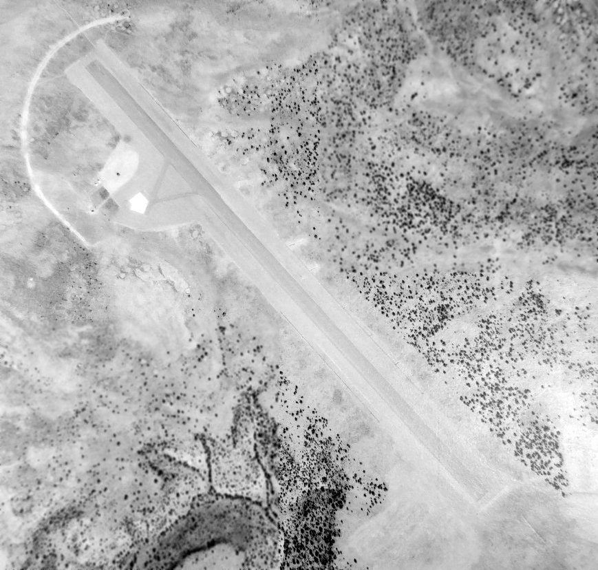
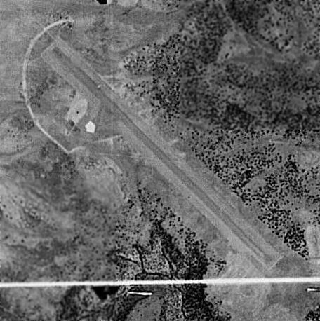
As seen in a 1993 USGS aerial view looking east showed the remains of the former Devil's Garden Airport paved runway remained intact, with a closed-runway “X” marking at each end.
It is not known if any of the buildings along the west side of the former runway were original airfield buildings.
A 7/5/15 photo by Jonathan Westerling looking north along the remains of the Devil's Garden Airport runway.
Jonathan Westerling reported in 2015, “The Devil's Garden Airport sits on a bluff 700' above Alturas.
The airport runway was asphalt at one time, however it has degraded to mostly gravel as of 2015.
However aside from a single small pile of rocks at one end, it remains clear & with relatively little vegetation.”
A 7/5/15 photo by Jonathan Westerling of “the remains of a windsock” at Devil's Garden Airport.
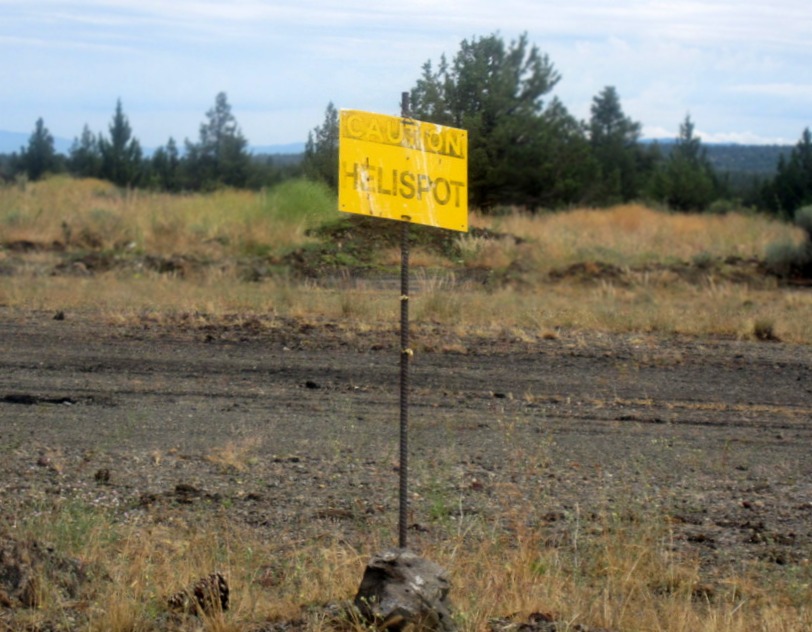
A 7/5/15 photo by Jonathan Westerling at Devil's Garden Airport of “a faded sign which indicate that helicopters may have continued to use the airfield more recently than fixed-wing aircraft.”
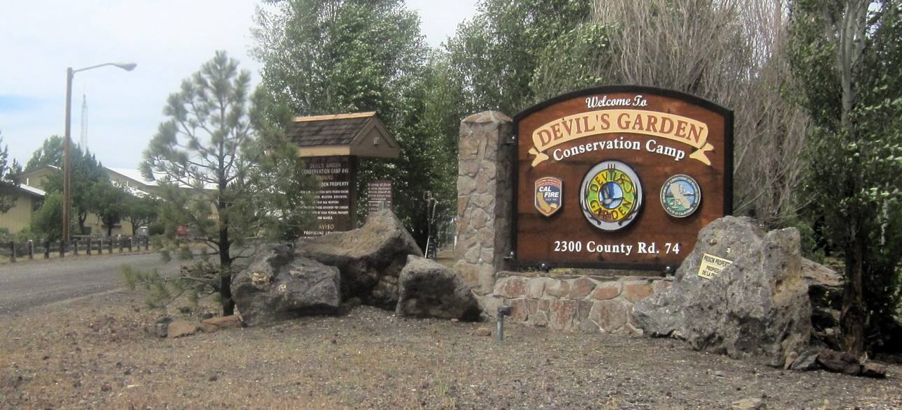
A 7/5/15 photo by Jonathan Westerling of the sign at the entrance to Devil's Garden Airport.
Jonathan Westerling reported. “The state's fire agency runs a camp at this location which trains prison inmates (those with good behavior?) to help fight forest fires.”
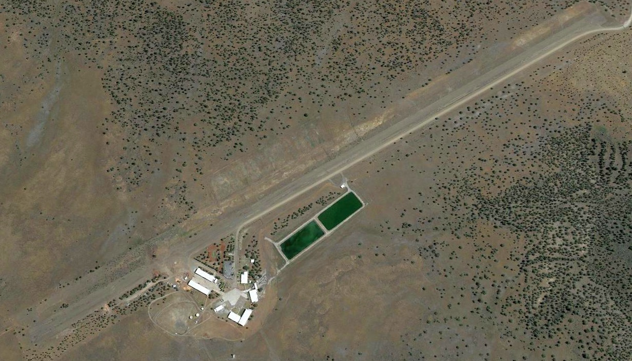
A 2015 aerial view looking east showed the former Devil's Garden Airport paved runway still remained in fairly decent condition, only somewhat deteriorated.
Pamela Bumstead reported in 2018, “The southeast end of the airfield is currently undergoing renovation for holding wild horses
(we have more on the land than can be supported) - Double-Devil Short-term Holding Facility.”
The site of Devil's Garden Airport is located one mile northwest of the intersection of Crowder Flat Road & Airport Road, appropriately enough.
____________________________________________________
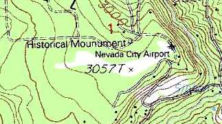
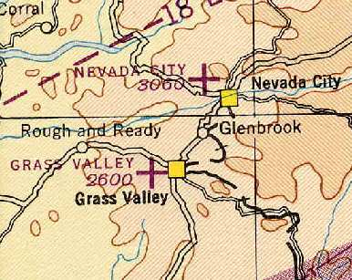
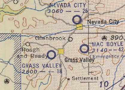
Nevada City Airport, Nevada City, CA
39.276, -121.028 (Northeast of Sacramento, CA)
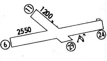
Nevada City Airport, as depicted on the May 1936 Sacramento Sectional Chart.
Photo of the airfield while in use has not been located.
The original airport for the town of Nevada City was located approximately one mile northwest of the town.
The date of construction of the field has not been determined.
It was evidently built at some point between 1934-36,
as it was not listed among active airfields in the 1934 Department of Commerce Airport Directory (according to Chris Kennedy).
The earliest depiction of the Nevada City Airport which has been located was on the May 1936 Sacramento Sectional Chart.
It depicted Nevada City as a commercial/municipal airport.
The Airport Directory Company's 1937 Airports Directory (courtesy of Bob Rambo)
described Nevada City as an auxiliary airfield located one mile northwest of the town,
having 2 runways in a cross shape, with the longest being a 3,000' northeast/southwest strip.
The 1943 Sacramento Sectional Chart (courtesy of Chris Kennedy)
depicted Nevada City as a commercial/municipal airport.
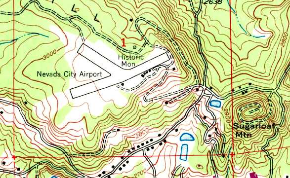
The 1948 USGS topo map depicted the “Nevada City Airport” as having 2 runways,
with 5 small buildings adjacent to the south side, and a “Historic Monument” on the north side.
According to an article entitled “Nevada City's Old Airport – What Now” in the 12/21/81 The Independent (courtesy of Greg Archbald),
the airport became inactive in 1961 after a fire consumed the hangars.

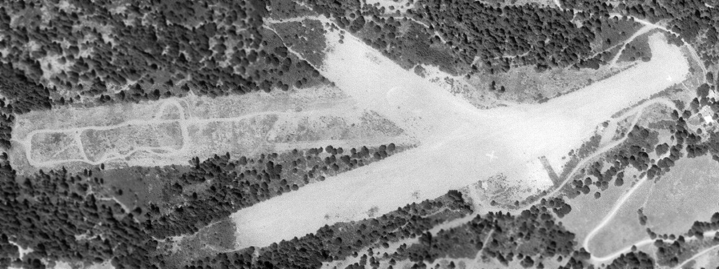
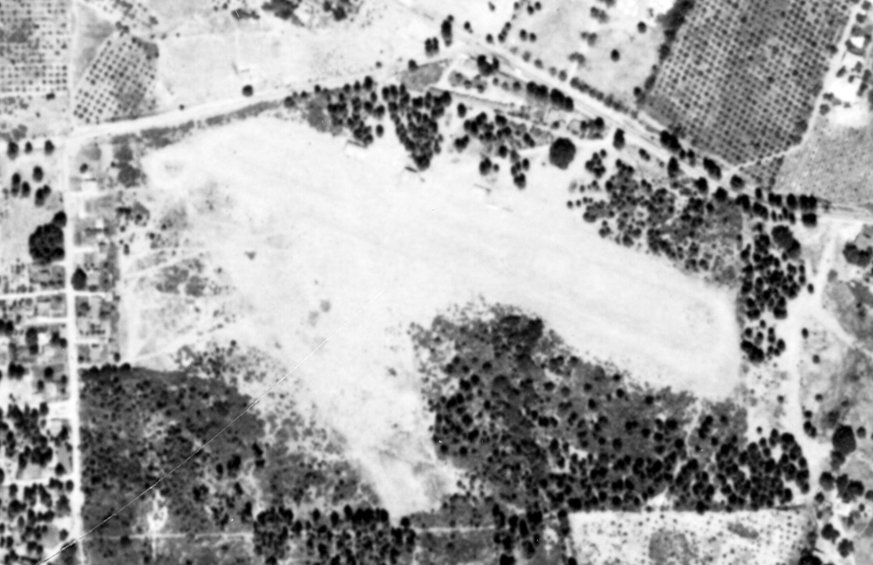
The earliest photo which has been located of Nevada City Airport was an 1962 aerial view (from the USCB Library, courtesy of Kevin Walsh).
It 2 unpaved runways, with a few small buildings on the north & east sides, and 1 light single-engine aircraft parked on the east side.
According to an article entitled “Nevada City's Old Airport – What Now” in the 12/21/81 The Independent (courtesy of Greg Archbald),
Nevada City Airport "was officially relegated to the status of inactive airport" in 1966.
However, Nevada City Airport continued to be depicted as an active airport in official documents for several more years.
Nevada City was still depicted as a public-use airport on the 1967 Sectional Chart (courtesy of John Voss),
and described as having a 2,500' unpaved runway.
Ray Foster recalled, “Nevada City Airport... as a kid we played football on the dirt runaway, rain or shine.
We also rode horses & mini bikes on the airport when it was still usable.
Periodically planes would land & stay parked at the site. Once in a while they parked on our football field at the far east end & screwed up our games.
There were still 2 buildings at the site when we were kids.
There was a white 2-story building & a wood hangar-type building.
In the spring time we would pull up long grass with the dirt stuck to the bottom & have war games in the 2-story building.
The windows had been broken out before we moved to the area in mid-1960s.
At the end of the west runway the City once installed a 'Hare Scramble' motorcycle course. The plan was to have races but it never took shape.
We were a select few who had our own mini bike moto cross just as moto cross was becoming popular.”
Ray continued, “Once while we were messing around with our friends a plane came into land & they almost landed on a few of the kids on the main trip.
We couldn’t hear it coming in over our mini bikes & when I looked back I was kind of blinded by the late afternoon sun.
The pilot pulled up abruptly & went around for another approach. Once he knew we were all off the field he landed.
It’s amazing how few other people ever discovered the old airport.
I constantly give thanks that our parents decided to move to Nevada City because in a way we grew up in our own private theme park.
Mini bikes, horses and shooting shotguns & 22 rifles with no one within miles.
Though we were lucky enough to drive at a very young age the airport was a great practice site.
No trees or other obstacles to hit & back then hardly a rock was worked loose.
As the years went by ruts began to cut up parts of the runway, brush began to grow & soon small trees started to fill in areas.
As we began getting older we got busy with after school sports, girls & of course work.
When we were kids there was a large white pee gravel X on the southeast side of the airport.
We were told that meant the airport was abandoned.
The airport was a playground to us & we sure were lucky kids.”
The airfield layout of Nevada City Airport, from a 1968 airport directory (courtesy of Chris Kennedy).
A 8/3/69 USGS aerial view depicted Nevada City Airport as having the 2 unpaved runways previously seen, along with a 3rd longer unpaved east/west runway, which appears to have been partially cleared.
A large white closed-runway “X” symbol was visible in the center of the field, and 1 light single-engine aircraft was visible on the east end of Runway 6/24.
At some point between 1968-70, the status of Nevada City Airport apparently changed to a private field,
as that is how it was depicted as an active airfield on the 1970 Sacramento Sectional Chart (courtesy of Dann Shively).
It was described as having a 2,500' unpaved runway.
Nevada City Airport was finally closed (for reasons unknown) at some point between 1970-77,
as it was no longer listed among active airfields in the 1977 Pilot's Guide to CA Airports (according to Chris Kennedy).
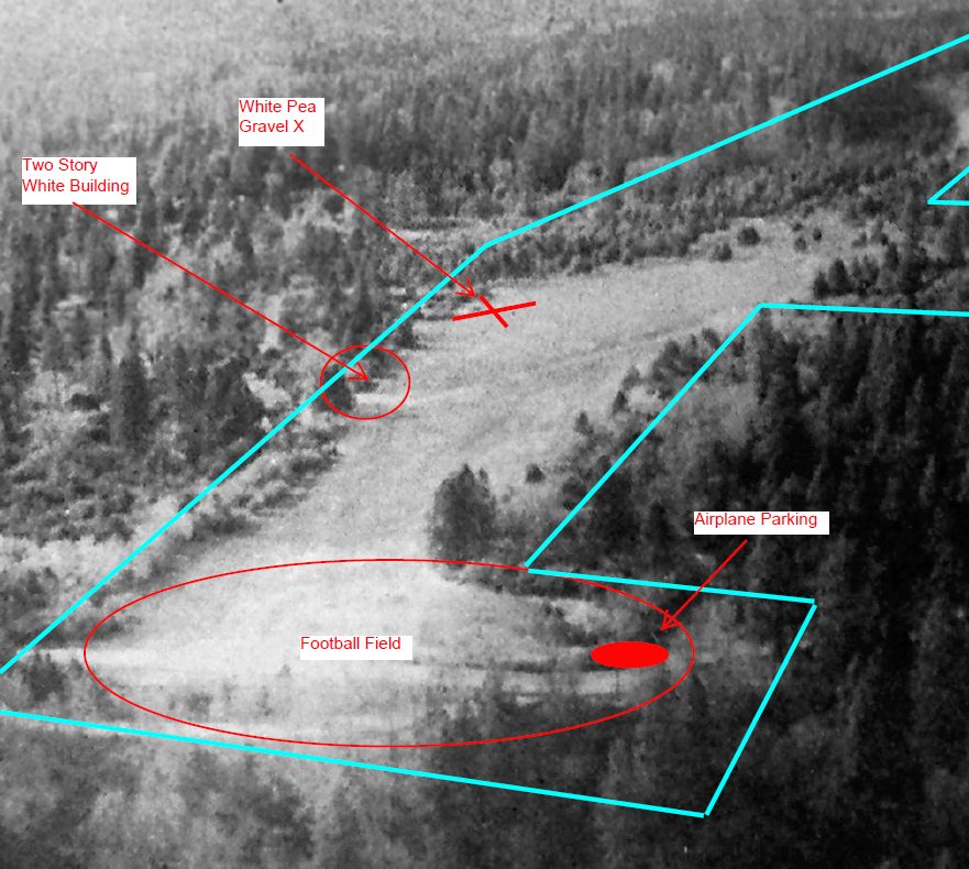
An undated aerial view by Bob Lickter of Nevada City Airport from a 1981 article
(courtesy of Greg Archbald, annotated by Ray Foster to show elements of the former airport).
Ray Foster recalled, “Our kids grew up on the same property next to the airport.
We took them for walks a few times but the brush & trees were taking back the airport by the 1980s.”
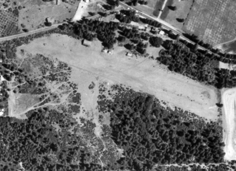
The 1993 USGS topo map depicted 2 runways, labeled simply as “Landing Strips”.
The 1995 USGS topo map still depicted the “Nevada City Airport”,
with a clearing of the 2 former runways, along with a “Historical Monument”.
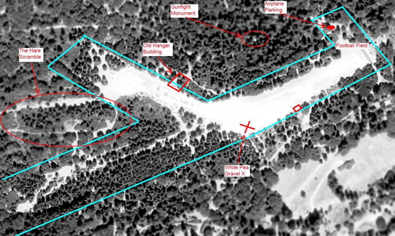
As seen in the 1998 USGS aerial photo, the outline of the northeast/southwest & northwest/southeast Nevada City Airport runways were still somewhat apparent,
although trees had taken over the southwestern half of the primary runway.
The photo was annotated by Ray Foster to show locations of former airport features.
A 2003 photo by Dann Shively of the northeast end of the primary runway at Nevada City.
Dann reported, “I don't think it was ever paved. There were 2 runways.
One running roughly northeast/southwest; the other running roughly southeast/northwest.
The site is now surrounded by pine trees.
There is a motocross track on the north/south runway where it intersects with the other runway.
It appears pine trees were planted long ago on the south portion of the north/south runway south of the motocross course.
No buildings or markings remain from the airport.”
A 2003 photo by Dann Shively of the motocross track [since removed] which occupied the middle of the former runway of the Nevada City Airport.
A 2003 photo by Dann Shively of trees over the southwest end of the primary runway at Nevada City.
A 2003 photo by Dann Shively of the northwest end of the shorter runway at Nevada City.
A 5/8/14 photo by Greg Archbald at the site of Nevada City Airport, of “the surface of the east end of the main runway.
While most of the remaining open runway area is dirt, there is some old asphalt pavement at this end.
Perhaps it was a reinforced runway apron in the area where most planes touched down.
There is no longer a motocross track on the field or anywhere else on the old airport property.
The field is now mostly flat dirt except a few places where the city or a related agency has piled materials
such as dirt or broken pavement from street work or slash from trimmed trees.”
A 5/8/14 photo by Greg Archbald at the site of Nevada City Airport.
Greg remarked, “There were hangars & I think I found what might be the cement floor of an old hangar, or at least a pad of some kind (for example a refueling area).
The location matches where the 1948 USGS topo map showed the hangars. The cement pad is at the east end of that row of hangars.”
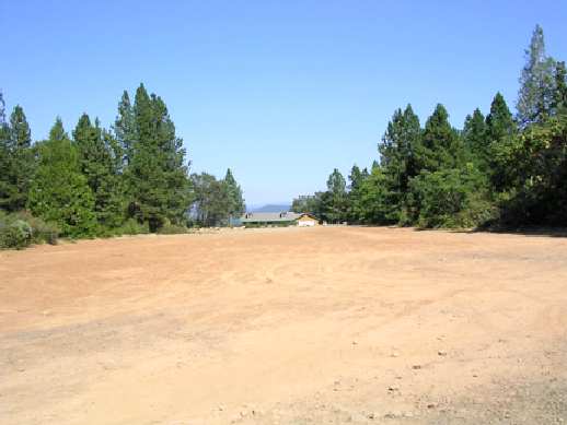
Alan Barbour reported in 2020, “The site of Nevada City Airport has been abandoned by Nevada City, which owns the property.
It
looks very different from 2003.”
A 2021 aerial view showed the alignment of the 2 Nevada City Airport runways were still somewhat apparent.
The site of Nevada City Airport is located on the western terminus of Airport Road, appropriately enough.
____________________________________________________
Grass Valley Airport / Gilmore Airport, Grass Valley, CA
39.22, -121.07 (Northeast of Sacramento, CA)
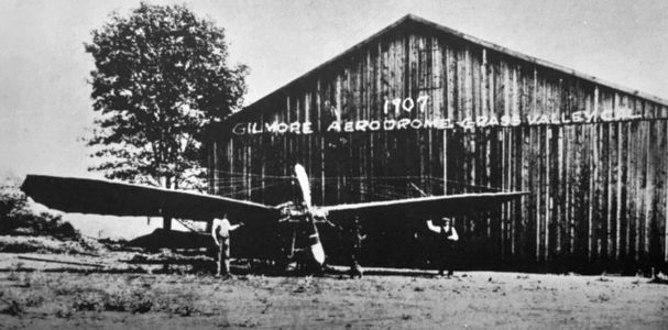
A circa 1911 photo of 3 men & an unidentified aircraft (presumably Lyman Gilmore & an aircraft of his design) in front of a hangar at Gilmore Aerodrome (courtesy of Kevin Walsh).
Dann Shively reported, "The original Grass Valley Airport was located just west of the downtown area on the Rough & Ready Highway.
Believe it or not this area was used as an airfield from before 1900.
There was an inventor in Grass Valley named Lyman Gilmore who was interested
in flight and experimented with airplanes & gliders around the turn of the century.
Some claim he beat the Wright Brothers with powered flight but there's no definite proof.
Eventually that site developed into Grass Valley's airport."
The date of construction of Gilmore / Grass Valley Airport has not been determined.
The earliest depiction which has been located of Gilmore Airport
was a circa 1911 photo of 2 men & an unidentified aircraft (presumably Lyman Gilmore & an aircraft of his design) in front of a hangar at “Gilmore Aerodrome” (courtesy of Kevin Walsh).
Mark Lincoln reported, “The airplane shown is Gilmore’s 1911 design which attempted to fly on 2 occasions both of which failed.
The 1911 airplane shown was simply too heavy to fly with its 35 or 50 hp engine.”
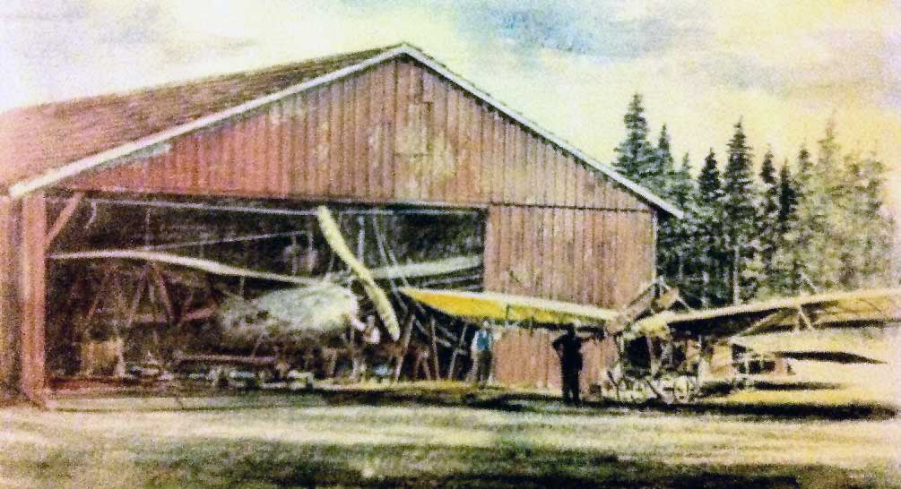
A circa 1911 photo colorized by George Mathis (courtesy of Judy Peterson) of 2 airplanes at the Gilmore Airport hangar.
Mark Lincoln reported, “The airplane outside the hangar was built in 1911.”
An article entitled “Chute Jumper to Leap from Plane at Gilmore Field" in the November 1928 Morning Union (courtesy of Kevin Walsh) reported,
“The flyers expressed their satisfaction of the local prospective airport.”

Grass Valley Airport, as depicted on the 1929 "Rand McNally Standard Map of CA With Air Trails" (courtesy of Chris Kennedy).
The 1929 "Airplane Landing Fields of the Pacific West" (courtesy of Chris Kennedy)
described Gilmore Field as being operated by Lyman Gilmore.
It was said to have 2 graded runways (with the longest being a 2,100' east/west strip),
and a hangar marked "Gilmore Field" & "Grass Valley" was said to be located on the south side of the field.
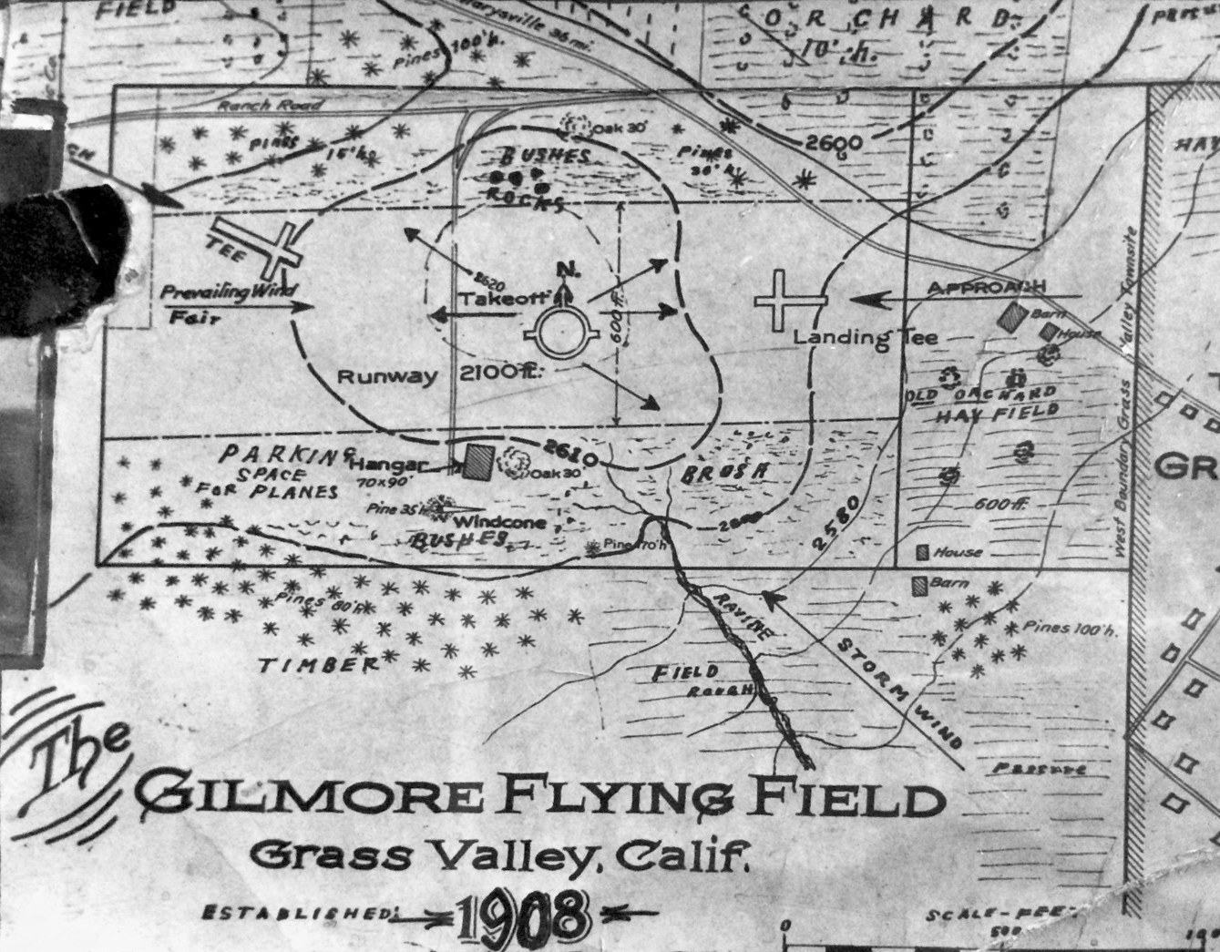
An
undated plan of “Gilmore Flying Field”, photographed in
2019 by Jonathan Westerling as displayed in the Nevada County
Historical Society's "Firehouse No. 1 Museum" in Grass
Valley.
It depicted Gilmore as having a 2,100' east/west unpaved runway, and a hangar on the south side.
The earliest aeronautical chart depiction which has been located of Gilmore Field was on the May 1936 Sacramento Sectional Chart.
It depicted “Gilmore” as a commercial/municipal airport.
The 1939 Sacramento Sectional Chart (courtesy of Dann Shively) depicted Grass Valley as a commercial/municipal airport.
Grass Valley Airport may have been temporarily closed at some point between 1939-43,
(due to wartime security concerns, like many other small civil airports during WW2),
as it was not depicted on the 1943 Sectional Chart (courtesy of Chris Kennedy).
Grass Valley Airport had apparently reopened at some point between 1943-44,
as it was depicted as a commercial airport on the 1944 Sacramento Sectional Chart (courtesy of Chris Kennedy).
A 1945 Grass Valley Chamber of Commerce map (courtesy of Kevin Walsh) labeled Gilmore Airport as the “First flying field in the west.”
It depicted the field as an irregularly-shaped property outline with a small hangar on the north side.
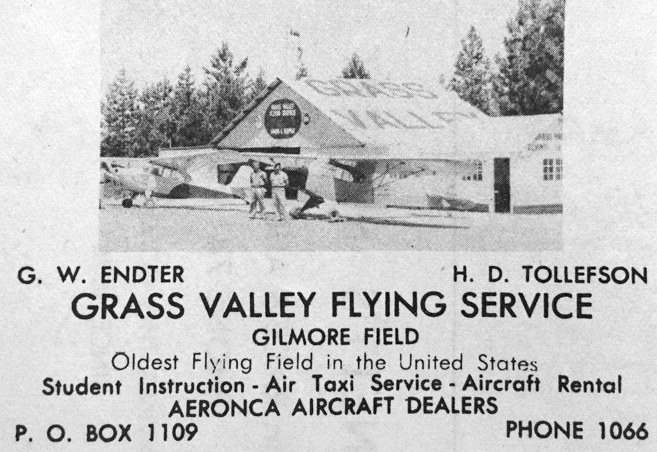
An advertisement for Gilmore Field's Grass Valley Flying Service from a 1945 Grass Valley Chamber of Commerce map (courtesy of Kevin Walsh).
The undated photo depicted an Aeronca & Piper Cub in front of a hangar painted “Grass Valley”.
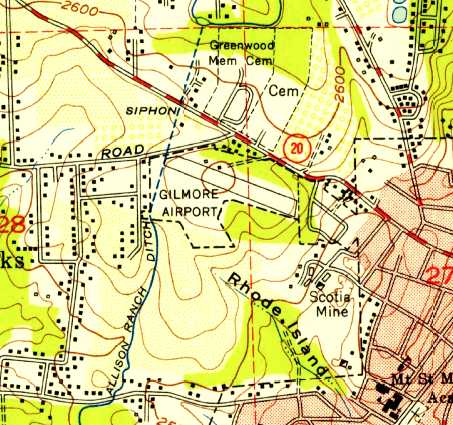
The 1949 USGS topo map depicted Gilmore Airport as having a single northwest/southeast runway, with 2 small buildings on the north side.
The 1949 Sacramento Sectional Chart (courtesy of Chris Kennedy) described Grass Valley as having an 1,800' unpaved runway.
A 1952 aerial view (from the UCSB Library, courtesy of Jonathan Westerling) depicted Grass Valley Airport as having 2 unpaved runways,
with a few small buildings (& possibly some light aircraft) on the north side.
Grass Valley Airport was still depicted on the March 1954 USAF Sacramento Sectional Chart (courtesy of Chris Kennedy).
At some point between 1954-57, the Grass Valley Airport was closed
and the airport moved to the east side of town where it remains as Nevada County Airport.
Grass Valley Airport was no longer depicted on the 1957 Sacramento Sectional Chart (courtesy of Chris Kennedy).''
A 1962 aerial view (from the UCSB Library, courtesy of Jonathan Westerling) depicted Grass Valley Airport as having a northwest/southeast unpaved runway,
with the remnants of a crosswind runway, and a few small buildings on the north side.
An undated photo from a 1965 book depicted a tattered (nonairworthy) unidentified taildragger light aircraft with the Gilmore Airport runway in the background (courtesy of Kevin Walsh).
In 1972, a historic plaque was dedicated at the site of the former "Gilmore Flying Field".
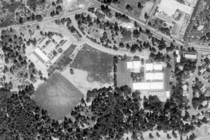
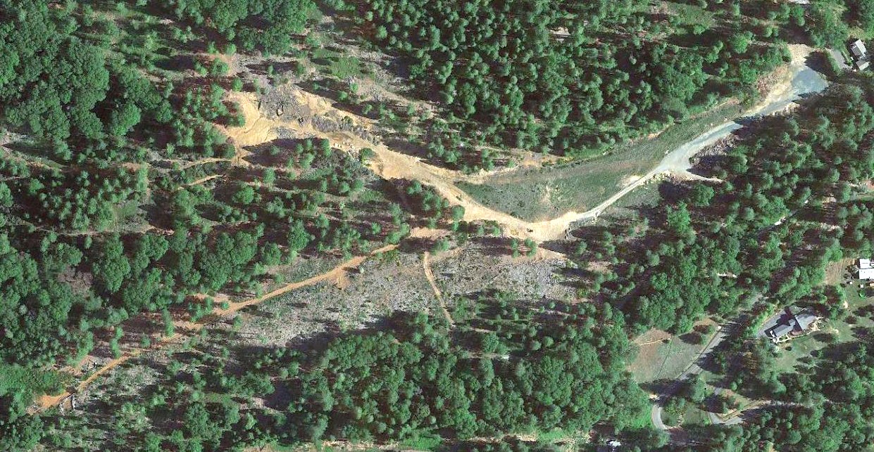
As seen in the 1998 USGS aerial photo, the Lyman Gilmore Middle School had been built on the site of the former Grass Valley Airport,
and not a trace of the former airport still remained.
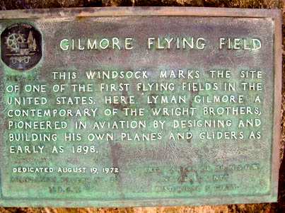
A 2003 photo by Dann Shively of the memorial plaque at the Lyman Gilmore Middle School.
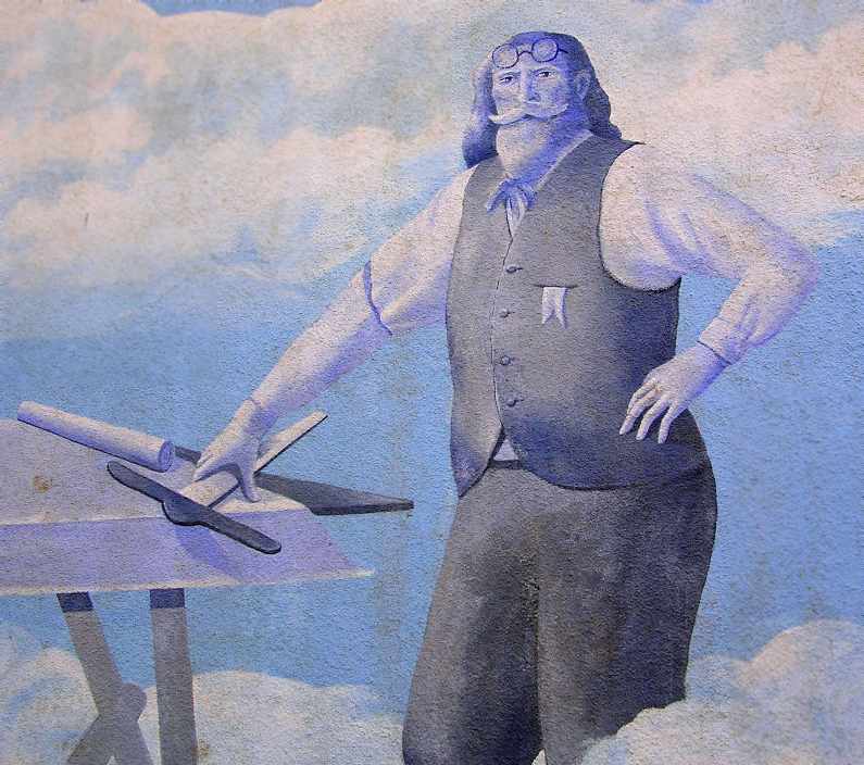
A 2003 photo by Dann Shively of the mural of Lyman Gilmore at Lyman Gilmore Middle School.
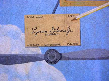
A 2003 photo by Dann Shively of the mural of Lyman Gilmore at Lyman Gilmore Middle School.
A 2017 photo of the windsock in front of Lyman Gilmore Middle School.
The site of the Grass Valley Airport is located south of the intersection of West Main Street & Gilmore Way.
____________________________________________________
Oroville Auxiliary Army Airfield #5, Oroville, CA
39.58, -121.64 (North of Sacramento, CA)
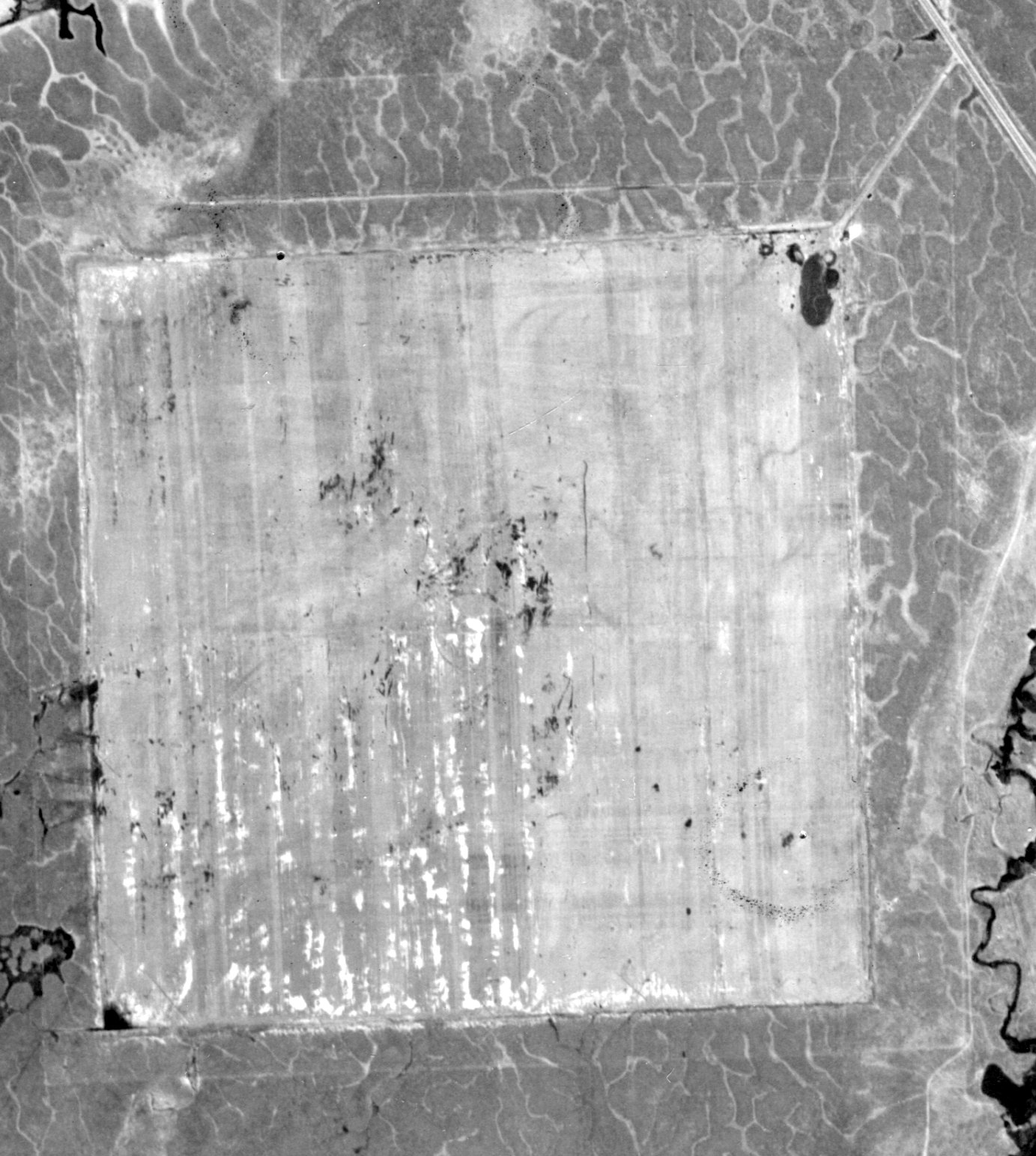
A 10/14/1942 AAF aerial view of Chico AAF / Oroville Auxiliary A5 (from the National Archives, courtesy of Brian Rehwinkel).
According to the Army Corps of Engineers, Oroville Auxiliary Field #5 was used during WW2
as one of the 5 auxiliary airfields which supported Chico Army Air Field (to the east), which was used to train fighter & bomber pilots.
The date of establishment of Oroville Aux AAF #5 has not been determined,
but other Chico Auxiliary Airfields were established in 1942.
Oroville Aux AAF #5 was not depicted on 1941/42/43/44/45 Sacramento Sectional Charts.
The earliest depiction which has been located of Chico AAF / Oroville Auxiliary A5
was a 10/14/1942 AAF aerial view (from the National Archives, courtesy of Brian Rehwinkel).
It depicted the Oroville airfield as consisting of a paved rectangular landing mat.
The rectangular shape of the mat permitted aircraft to land in any direction, eliminating the possibility of a crosswind.
A small building (water tower?) sat in the center of the mat.
In addition to its use an airfield, the site was used as a practice precision bombing range
and dive-bombing & skip-bombing training range.
In addition to the airfield, improvements to the site included a building, latrine, and fencing.
According to Tom Beamer, "My research has shown that the 3,000' square landing mats (Oroville)
were used by USAAF Basic (BT-13/15) Schools for takeoff & landing practice, mostly in the Western Region.
Close study will reveal interesting regional differences in USAAF airfield
layout due to each Corps of Engineers District solving the same problem differently."
In 1944, the federal government acquired fee title to 360 acres of land by four Declarations of Taking.
Oroville Aux AAF #5 was not depicted on the 1944/48/50/69/80 USGS topo maps.
On 10/1/1944, the site was classified by the U.S. Government as a surplus supply location.
On 6/18/45, the Oroville Aux AAF #5 site was reestablished as a landing field.
It was again reclassified as a surplus supply location on 11/1/46.
Two Contamination Certificates certified the site was inspected & decontaminated on 9/4/46.
All bombs were removed from the field & those with spotting charges were decontaminated.
On 2/28/47, 360 acres were transferred to the War Assets Administration.
A 1952 aerial view (from the UCSB Library, courtesy of Jonathan Westerling) depicted Oroville Auxiliary A5 as being abandoned.
John Sparks, who was born & raised in Oroville, reported that the Oroville Aux AAF #5 landing mat
"was used by a local model airplane club from the late 1980s until the late 1990s.
I contacted an individual in Chico & he says the field is not in use anymore due to a conflict with the property owner.
I am assuming the small clearing [visible on the above aerial photo] is the same clearing used by the model aircraft club."
As of the 1990s, the Butte County Assessors records indicated that the land was owned by local rancher.
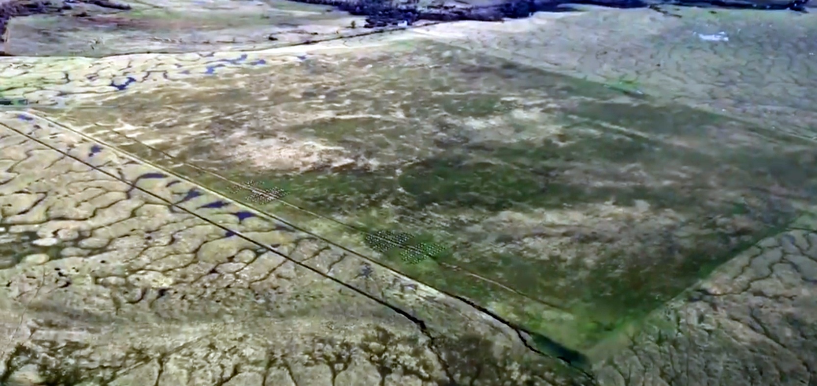
A 2006 aerial view by Dann Shively, showing the edge (almost indistinguishable) of the Oroville landing mat.
Dann observed, “You can make out straight lines & possibly the edge of the mat.
You wouldn't believe how hard it was to find at low level.
It doesn't look like the other mats I've encountered & it wasn't until I was right over it did I realize it was there!
It blends in with the surrounding countryside; it's all green.
I don't know if it was plowed up or if the pavement is so old grass is growing up through it.”
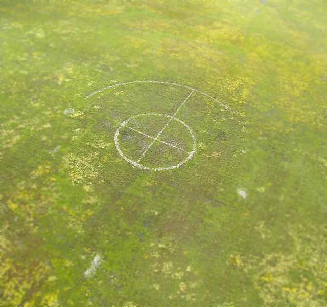
A 2006 aerial view by Dann Shively, showing the symbol (a former bombing target?)
which remains visible at the center of the Oroville landing mat.
Dann observed, “It's pretty big & certainly is not random. It appears to be made from carefully placed rocks. Yet another mystery.”
A 12/26/18 aerial view by Gonzalo (Peewee) Curiel looking southwest at the Oroville landing mat.
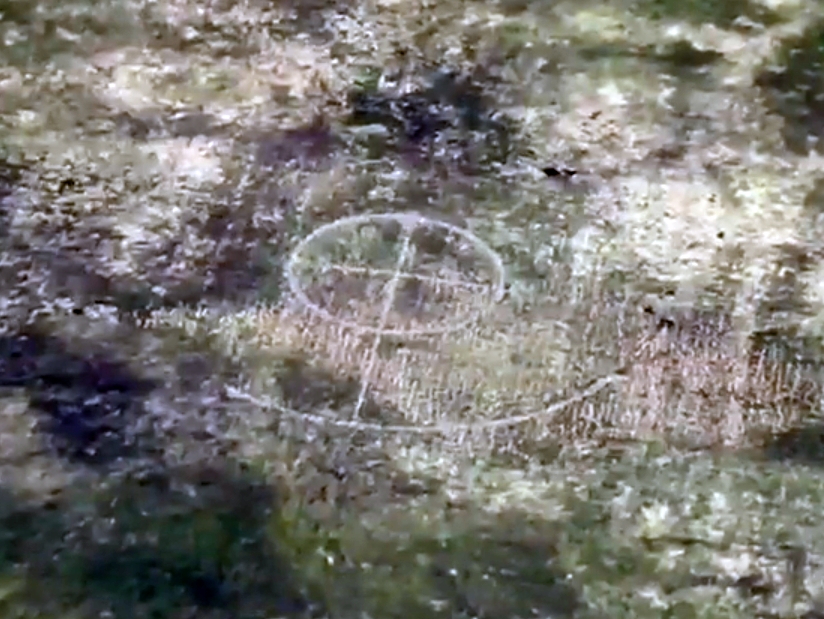
A 12/26/18 aerial view by Gonzalo (Peewee) Curiel of the target circle in the center of the Oroville landing mat.
The site of Oroville Aux AAF #5 is located west of the intersection of Route 70 & Route 149, 5 miles northwest of Oroville, CA.
____________________________________________________
____________________________________________________
This site covers airfields in all 50 states.