
Abandoned & Little-Known Airfields:
Northwestern California
© 2002, © 2026 by Paul Freeman. Revised 3/21/26.
This site covers airfields in all 50 states: Click here for the site's main menu.
For a 10th year, the CA pages of this website are sponsored by the California Pilots Association:
____________________________________________________
Please consider a financial contribution to support the continued growth & operation of this site.
AvAg Heliport (added 1/3/23) - Crazy Creek Gliderport (revised 8/2/24) - Enterprise Sky Park (revised 4/24/18) - Ft Bragg Airport (original location) / White Airport (revised 1/4/21)
Kirkwood Aux AAF #2 / Kirkwood Airport (revised 5/9/20) - Nolta Airfield / Noltas Airfield (revised 12/20/24) - Patrick Field (revised 2/5/24) - Paul Hoberg Airport (revised 7/3/23)
Pearce Airport / Pearce Field (revised 7/3/23) - Peterson Chico Airfield (revised 9/10/16) - Peterson Redding Airfield (revised 9/22/18) - Pinnegar Field (revised 12/12/19) - Point Arena Hotel Airfield (revised 8/21/19)
Redding Sky Ranch (revised 4/24/18) - Shingletown Airport (revised 9/16/23) - Stubbs Airport / Clear Lake Oaks Airport (revised 2/2/16) - Union Lumber Company Airfield (revised 2/4/24)
Williams Intermediate Field (revised 3/21/26) - (Original) Willits Airport (revised 5/10/20) - Willow Creek Airport (revised 5/10/20)
____________________________________________________
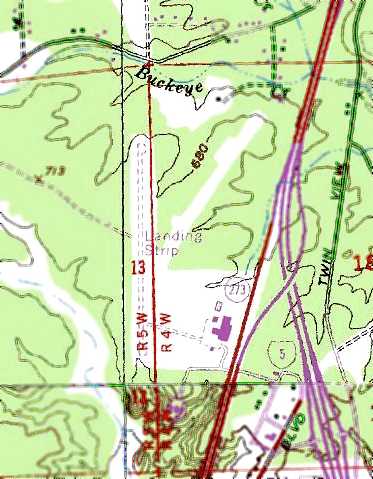
Nolta Airfield / Noltas Airfield, Willows, CA
39.581, -122.198 (Northwest of Sacramento, CA)

Nolta Airfield, as depicted on the February 1949 Sacramento Sectional Chart.
According to Ted Atlas, “Floyd Nolta became a pilot in the mid-1920s after serving as an aircraft mechanic in the Army in WW1.
Floyd established the Willows Flying Service at the Willows Airport.
Around 1940 the Noltas established their own airport, possibly in anticipation of losing access to the Willows Airport.
In July 1955 Joe Ely the Fire Control Officer for the Mendocino National Forest asked Floyd if he could develop a system to drop water from an airplane to assist in forest fires.
Within a week he had a tank in the front of the cockpit of his Stearman PT-17 along with a valve & control rope.
They tested the system at Nolta’s Airport on July 23 by lighting a strip of grass on fire & Vance flying over & dropping water, extinguishing the flame.
The Noltas dropped water on 5 fires that summer. That test at Noltas was very significant in the development of aerial fire fighting.”

The Willows Flying Service logo (courtesy of Ted Atlas).
Nolta Airfield not yet depicted on the 1948 Sacramento Sectional Chart.
The earliest depiction which has been located of Nolta Airfield was on the February 1949 Sacramento Sectional Chart.
It depicted Nolta as having a mere 1,900' unpaved runway.

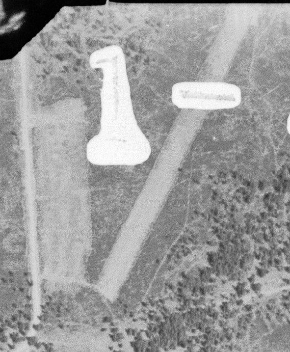
The earliest photo which has been located of Nolta Airfield was a 1955-56 photo (courtesy of Ted Atlas) of a man next to Tanker #1, N75081.

A 1956 photo (courtesy of Ted Atlas) of Robert Dasmann, Superintendent of the Mendocino National Forest, Floyd Nolta and Joe Ely, in front of Tanker #1 at Nolta's Airport.
According to Ted Atlas, “The US Forest Service recognizes this as the first air tanker.”

An undated photo of 5 biplanes in front of the hangar marked “Nolta's Airport” (courtesy of Ted Atlas).

An undated photo of the Noltas Airport Willows Flying Service sign (courtesy of Ted Atlas).

An undated photo of 3 biplanes at Nolta's Airport (courtesy of Ted Atlas).
The September 1960 Sacramento Sectional Chart continued to depicted Nolta as having a 1,900' unpaved runway.
Notla Airfield was evidently closed (for reasons unknown) at some point between 1960-65,
as it was no longer depicted on the June 1965 Sacramento Sectional Chart.

A May 1966 photo by Jay Sherlock of Moller Aviation Stearman PT-17D N2855D in front of a Noltas hangar.
Jay recalled, “The Stearmans at Noltas had apparently been sitting there for a while, so I can only conjecture that Noltas was a 'remote' operating field for Moller (their office address was in Maxwell),
or simply a convenient low-cost storage site.”

A May 1966 photo by Jay Sherlock of Moller Aviation Stearman N2S-3 N5050V in front of a Nolta Airfield hangar.

A May 1966 photo by Jay Sherlock of Moller Aviation Stearman PT-17 N5477V in front of a Nolta Airfield hangar.
Notla Airfield still was not depicted on the January 1967 Sacramento Sectional Chart.
The airfield was evidently reopened in 1967 under a slightly different name, as the June 1967 Sacramento Sectional Chart as “Noltas”.
Jay Sherlock recalled, in “April 1970 I shot a final Stearman there. In April 1973 at Noltas I saw a single Cub or Aeronca.”

The earliest topo map depiction which has been located of Noltas Airfield was on the 1974 USGS topo map.

The October 1989 San Francisco Sectional Chart (courtesy of Jay Sherlock) depicted Noltas as a private airfield having a 1,900' unpaved runway.

The last aeronautical chart depiction which has been located of Noltas Airfield was on the September 1997 San Francisco Sectional Chart.
It depicted Noltas as a private airfield having a 1,900' unpaved runway.

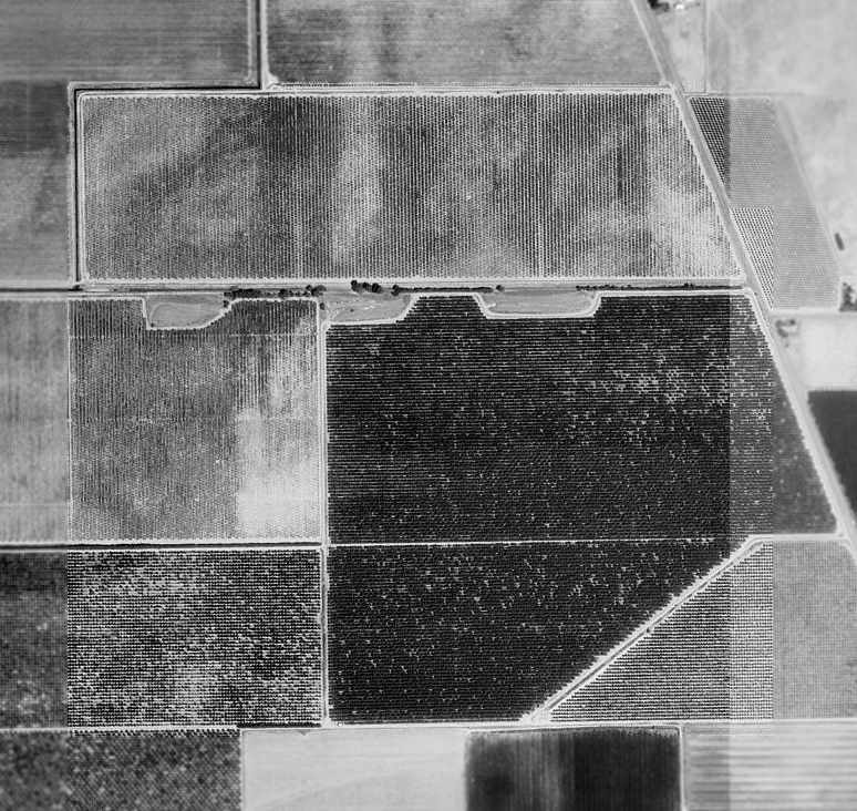
The last photo which has been located showing aircraft at Noltas Airfield was a 1998 aerial view,
which showed at least 2 single-engine aircraft parked near the buildings on the north side of the field.
Noltas Airfield was evidently closed (for reasons unknown) at some point between 1998-2016,
as it was no longer depicted on the 2016 San Francisco Sectional Chart.

A 2023 aerial view showed the Noltas Airfield runway had been removed at some point between 1998-2023, but the buildings remained on the north side.

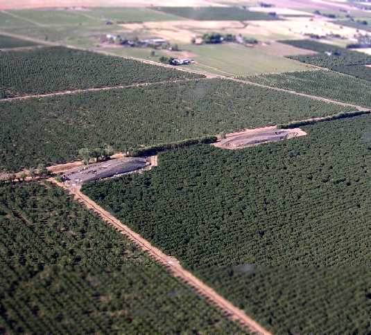
An undated (pre-2024) photo of the Noltas Airport site (courtesy of Ted Atlas).

A 2024 photo looking southeast showed a former Noltas Airfield hangar remained on the north side.
Thanks to Jay Sherlock for pointing out this airfield.
____________________________________________________
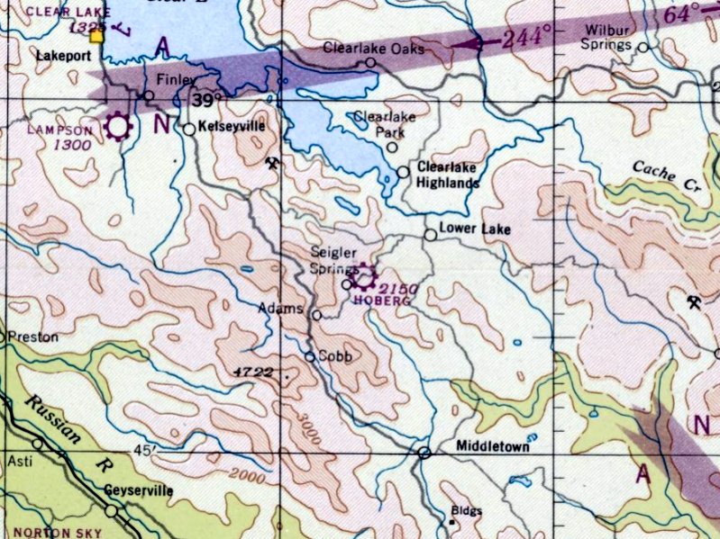
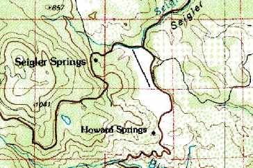
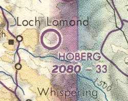
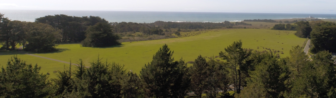
Paul Hoberg Airport, Siegler Springs, CA
38.87, -122.68 (North of San Francisco, CA)
Hoberg Airport, as depicted on the February 1947 Sacramento Sectional Chart.
According to Dann Shively, “Hoberg's Resort in the Cobb Mountain area of Lake County dates back to 1885.
From a lodge & a few cabins it grew into the largest privately owned resort in California.
It included a bowling alley, swimming pool, and dance hall, and could handle up to 1,000 guests for dinner.
In the 1940s & 1950s it was world famous & drew big name bands & celebrities & was a really jumping place.”
Hoberg Airport was evidently established at some point between 1946-47,
as it was not yet depicted on the September 1946 Sacramento Sectional Chart.
The earliest depiction which has been located of Hoberg Airport was on the February 1947 Sacramento Sectional Chart.
George Harper recalled, “I flew into Hobergs in 1948 & 1949.
The runway went up about 5 degrees, tree-lined, you landed up & took off down.
In the summer you had best arrive & depart before 10 am hot thermals.”
Sandra Hoberg Fox recalled, “My family used to own Hoberg's Resort & the airstrip.
My Grandfather George, and Uncle Frank Hoberg actively flew out of that airport during the 1940s through the early 1960s.
We had another desert resort in Borrego Springs, and they shuttled guests & workers back & forth.”
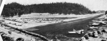
The earliest photo which has been located of Paul Hoberg Airport
was an undated photo from a circa 1950 brochure for Siegler Springs resort (courtesy of Kevin Walsh).
It depicted a large number of aircraft next to the runway.

The 1954 San Francisco Sectional Chart (courtesy of Dann Shively) depicted Hoberg as a public-use airport having a 5,300' unpaved runway.
A 1955 brochure for Siegler Springs resort (courtesy of Kevin Walsh) described Paul Hoberg Airport as having a 5,400' paved runway.
A 7/20/56 USGS aerial view depicted Paul Hoberg Airport as having a single unpaved northwest/southeast runway, with one small hangar on the northwest side.
The 1958 USGS topo map depicted “Hobergs Airport” as having a single paved northwest/southeast runway.
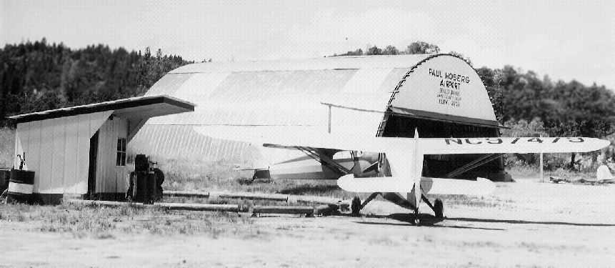
A circa 1958-59 photo of 2 taildraggers in front of a hangar marked “Paul Hoberg Airport” (courtesy of Sandra Hoberg Fox).
Sandra recalled, “Hoberg's had a resident photographer, Bud Taylor, who took many of the shots from back then.
He took publicity photos, and pictures of guests during dinners, etc.”
According to Dann Shively, a source in the CA Department of Forestry
indicated that Hoberg's “was an early air tanker [aerial firefighting] base in the mid 1950s.”
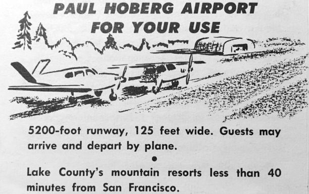
A description of Paul Hoberg Airport from 1960 brochure for Siegler Springs resort (courtesy of Kevin Walsh).
The 1961 San Francisco Sectional Chart (courtesy of Dann Shively)
continued to depict Hoberg as a public-use airport having a 5,300' unpaved runway.
Don White recalled, in about 1964, “My dad used to fly from the Calistoga Airport to Hobergs to get work done on his Bonanza & Tripacer.
I remember landing there with him quite a few times. There was a small hangar on the north end of the field. The mechanic was Carl Hutchings.
One time we were there & my dad was working with Carl on his plane. I got bored & was wandering all over the area around the airfield.
I heard a riding lawnmower approaching & there it came with an older kid riding it. He had a rifle over his shoulder & I imagined he had a threatening look on his face.
I took off towards the north end where my dad was. I thought he might shoot me!””
According to Dann Shively, “The 52-acre resort started a decline in the 1960s & was sold by the Hoberg family in 1971.
The airport apparently was not part of the sale.
It was officially later named the Paul Hoberg Airport.”
Don White recalled, in 1972, “A friend & I rode my Yahama 100 up there from Calistoga. The airport was very quiet then.”
The 1974 USGS topo map depicted the single runway of Hoberg Airport, but did not label the field at all.
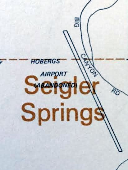
The Hoberg Airport was evidently closed by 1982,
as a 1982 road atlas (courtesy of Kevin Walsh) depicted it as “Hobergs Airport (Abandoned)”.
The 1990 San Francisco Sectional Chart (courtesy of Dann Shively)
still depicted Hoberg as a public-use airport having a 3,300' unpaved runway,
in spite of the 1982 depiction of it already having been abandoned.
According to Dann Shively, “At some point between 1990-2005 it was shown to be a private strip.”
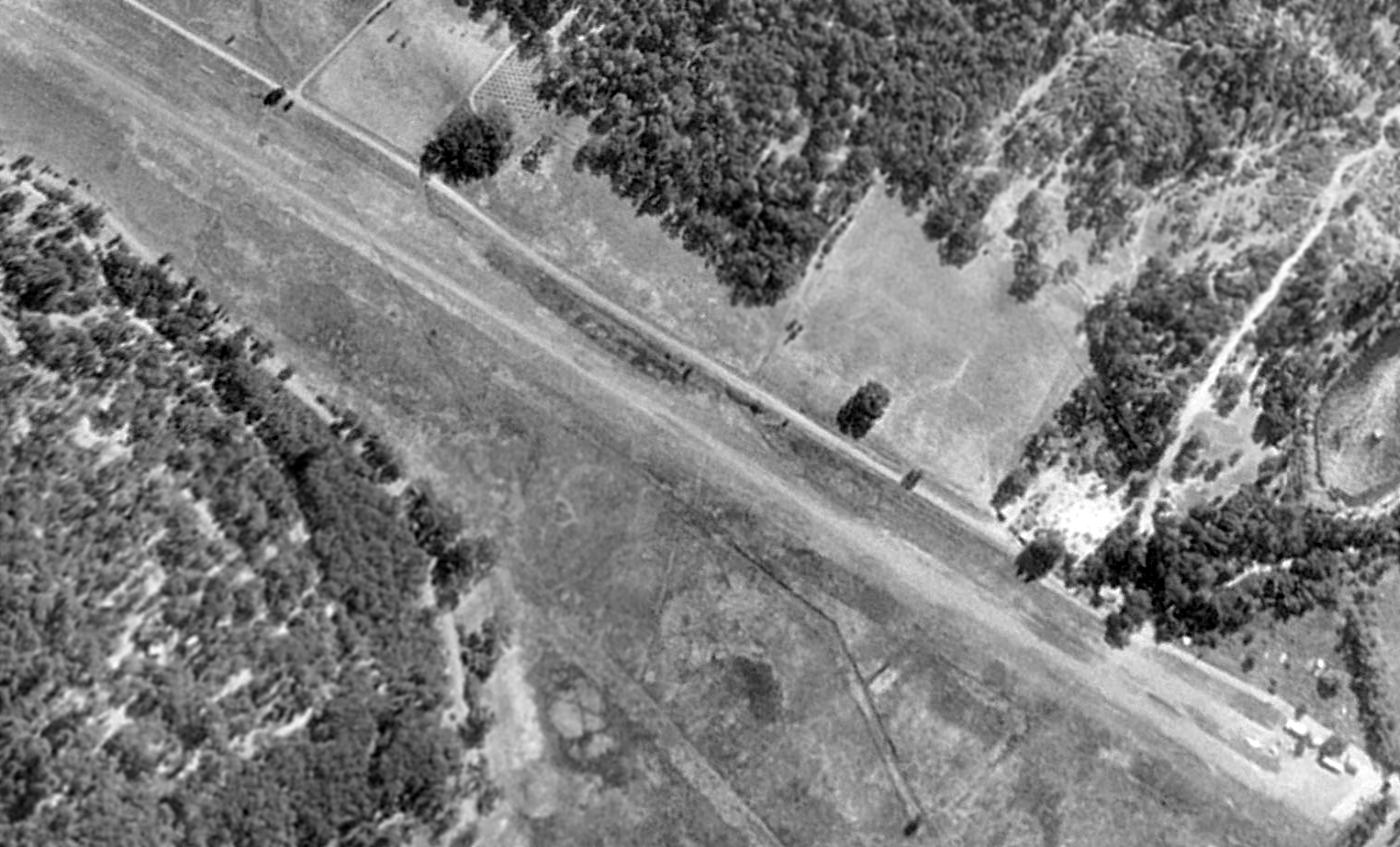
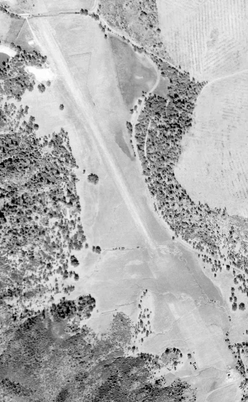
A 1993 USGS aerial view looking southwest showed the Hoberg Airport to be completely intact.
What could be a single aircraft was visible near the buildings at the bottom-right.
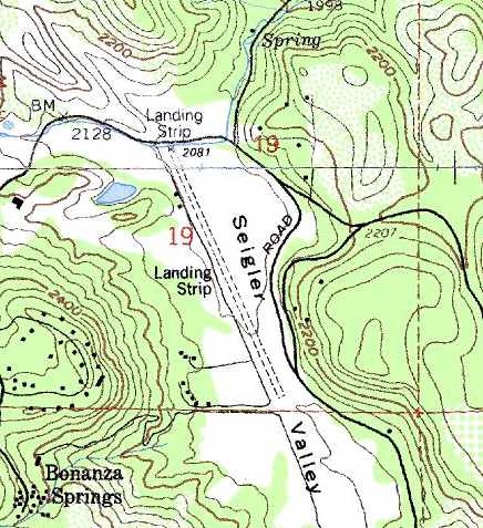
The 1999 USGS topo map depicted the single runway of Hoberg Airport,
labeled simply as “Landing Strip”.
Hoberg Airport was depicted as an abandoned airfield on the 2005 San Francisco Sectional Chart (courtesy of Dann Shively).
A 2006 aerial view by Dann Shively, looking south at the abandoned Hoberg Airport.
Dann Shively reported in 2006 that the former resort “is currently a retreat center known as the Cobb Mountain Forest Retreat Facility.”
He reported that the former airfield is “deteriorated somewhat but not in terrible shape.
The runways are X'ed out.
The strip runs North/South & on the north end there's still a hangar & small building.”
A 2006 close-up aerial view by Dann Shively of the abandoned hangar at the former Hoberg Airport.
The Cobb Mountain Forest Retreat Facility was listed as being For Sale in 2006.
Sandra Hoberg Fox reported in 2006, “The Hoberg Airstrip is next to a gated meditation retreat (Adidam) that used to be Seigler's Hot Springs Resort,
and the Adidam group bought an acre out of the center of the Hoberg airstrip to make it unusable.
My Grandmother had donated the airport property to Lake County, and the county sold a piece to the Adidam group.
She gifted the land because she was worried about possible liability if anyone had an accident there.
The old Hoberg's Resort is for sale, and it is in dismal condition.
I still live on the property in my grandparents old home - basically the hole in the donut.
Many people look at the property, but the condition is so terrible that it would be a huge undertaking to restore or tear down the buildings.
It shows what 35 years of neglect does to a once lovely property.
The buildings are all empty, and they haven't had a Transcendental Meditation Course in many months. The asking price is $3 million plus.”
Jonathan Westerling reported in 2015, “According to the CDF maps, Seigler Springs burned over the weekend.
It's most likely that the area surrounding Hoberg Airport was incinerated.”
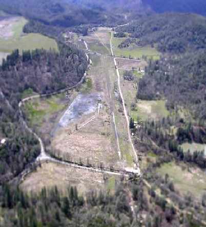
A 2016 aerial view looking southwest showed the Hoberg Airport runway to remain intact though deteriorated.
A 2021 photo looking southeast at the foundation of the former Hoberg Airport hangar, with the runway area in the background.
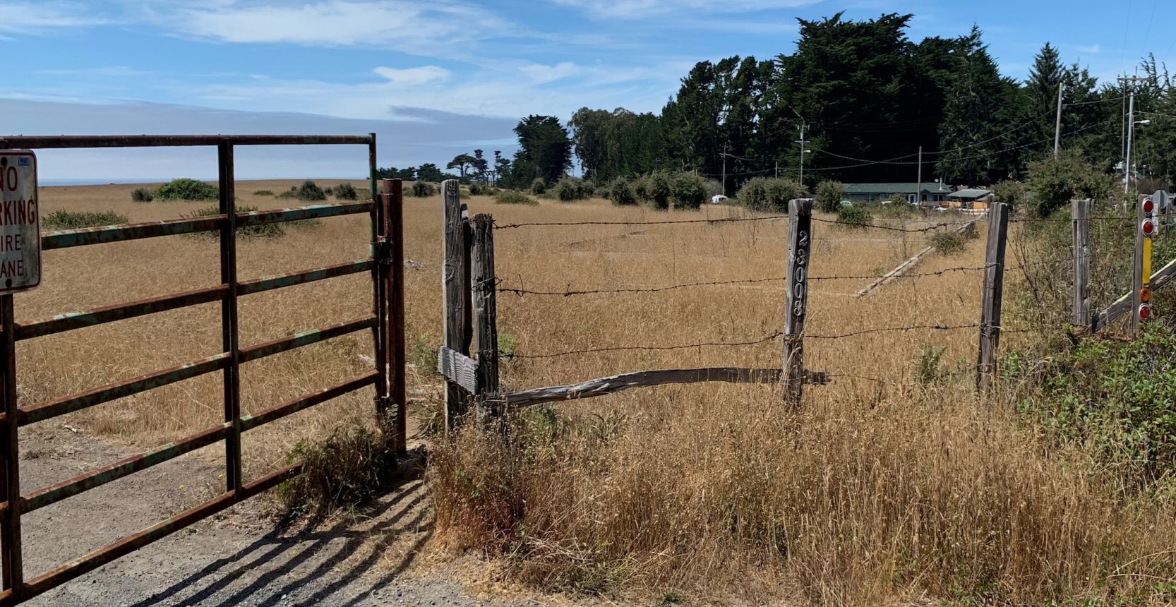
The site of the Hoberg Airport is located south of the intersection of Siegler Canyon Road & Loch Lomand Road.
Thanks to Dann Shively for pointing out this airfield.
____________________________________________________
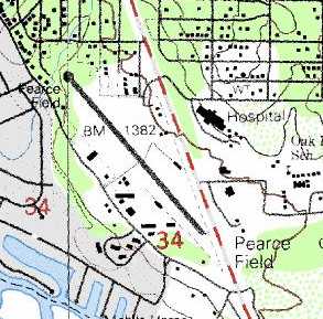
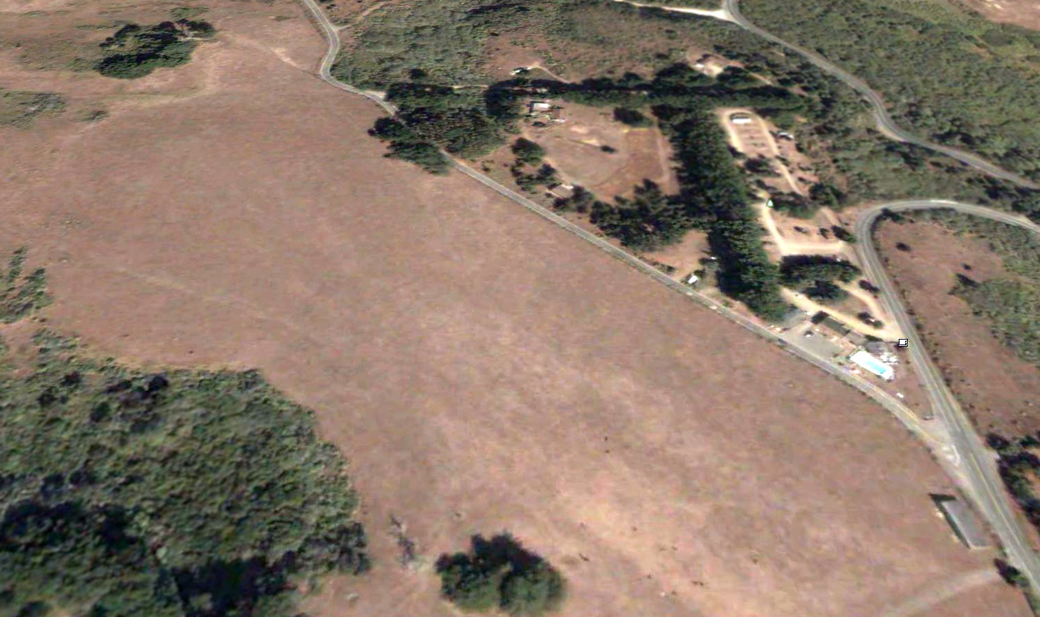
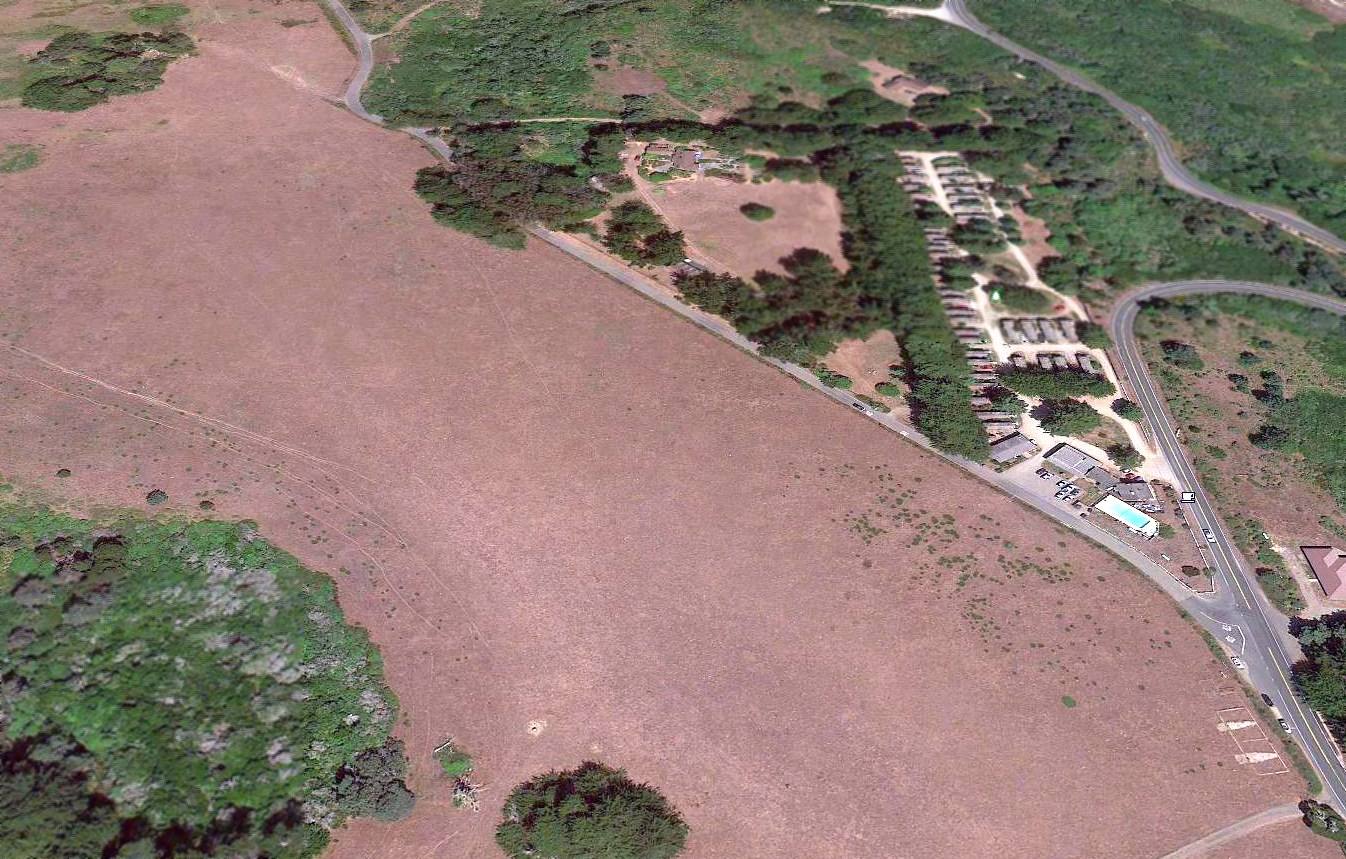
Pearce Airport / Pearce Field (CKE), Clearlake, CA
38.935, -122.623 (North of San Francisco, CA)
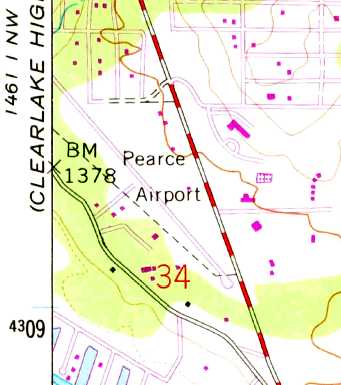
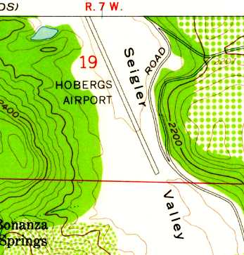
The 1958 USGS topo map depicted Pearce Airport as having a single paved northwest/southeast runway.
This small general aviation airfield was apparently built at some point between 1947-58,
as it was not yet depicted on the 1947 USGS topo map.
The earliest depiction which has been located of Pearce Airport was on the 1958 USGS topo map.
depicted Pearce Airport as having a single paved northwest/southeast runway,
with several small buildings on the southwest side.
Pearce Field was not depicted on the 1961 Sectional Chart (according to Dann Shively).
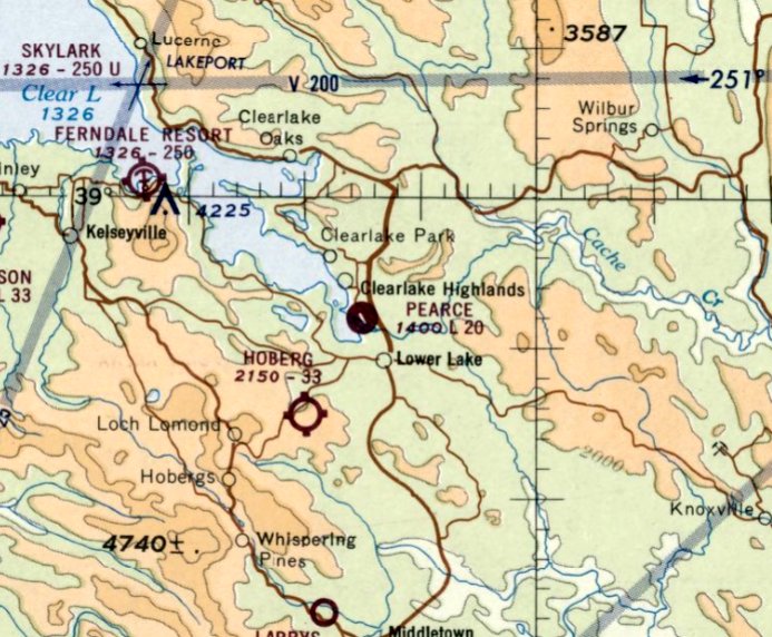
The earliest aeronautical chart depiction which has been located of Pearce Field was on the June 1965 Sacramento Sectional Chart.
It depicted Pearce Field as having a single 2,000' northwest/southeast paved runway.
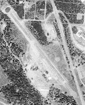
The earliest photo which has been located of Pearce Field was a 5/1/70 USGS aerial view.
It depicted Pearce Field as having a single asphalt northwest/southeast runway, and several small buildings on the southwest side.
Pearce Field was listed among active airfields in the 1977 Pilot's Guide to CA Airports (according to Chris Kennedy).
Kelly Spangler recalled, “Pearce Aero... My mother & stepfather owned & lived on that property for many years prior to its closure.
They owned & operated Pearce Aero as a Fixed Base Operator & a glass business on site.
Our home was located just above the main office & hangar . I even learned to drive by racing up & down that runway.”
Dann Shively recalled, "In January of 1983, I covered a plane crash there.
The pilot tried to take off after an aborted landing attempt
and crashed into a senior citizen apartment complex off the end of Runway 30.
There were injuries but no fatalities in the plane or on the ground.
A few years later there was a fatal helicopter training accident.
Both these incidents probably contributed somewhat to the eventual closure."
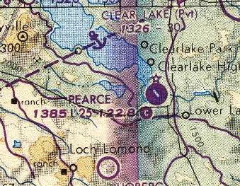
Pearce Field, as depicted on the 1990 San Francisco Sectional Chart (courtesy of Dann Shively).
The 1990 San Francisco Sectional Chart (courtesy of Dann Shively)
depicted Pearce Field as having a single 2,500' paved northwest/southeast runway.
A 1993 USGS aerial view looking north showed Pearce Field to consist of a single 2,500' asphalt Runway 12/30, and several small ramps & hangars.
The airport was apparently well used, as a total of 13 aircraft were visible parked outside in the photo.
Pearce Field was closed in 1994.
According to David Heal, "Pearce Field… was closed by the City or County (I'm not sure which one)
when a MacDonalds fast food joint was proposed to be built in the southern approach path to the runway.
The County looked at a replacement site on top of a nearby hill,
but no one in the County was really interested in developing the site.”
The 1999 USGS topo map continued to depict Pearce Field.
Pearce Field was no longer depicted at all (even as an abandoned airfield) on 2002 aeronautical charts.
David Heal reported in 2003: "The southern portion of the old airfield was developed into a water-amusement park.
The northern portion of the paved runway & some hangars are still visible."
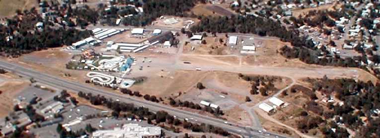
with the water park covering the south end of the runway.
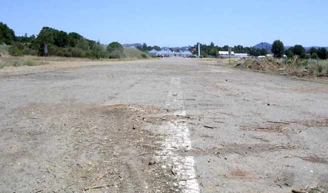
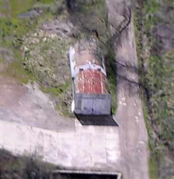
A 2004 photo by Dann Shively, looking down the remains of Pearce Field's Runway 12.
"You can see some of the center line is still evident. At the other end (the southeast end) sits the water park."
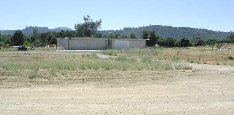
A 2004 photo by Dann Shively of the 2 hangars which still remained on the west side of Pearce Field.
He reported that a length of the former runway & these 2 former hangars are all that remain of the former airport.
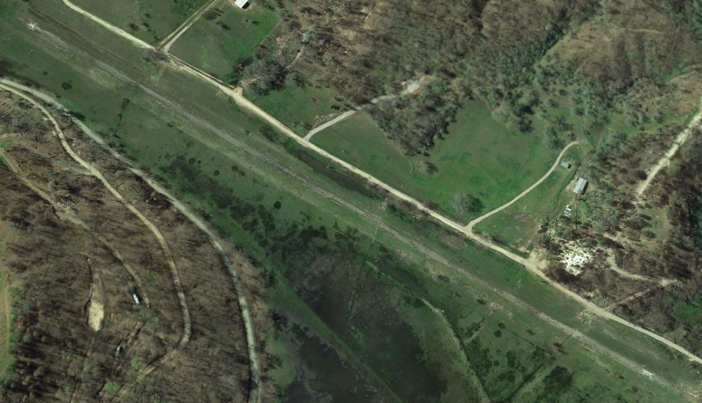
A 2013 aerial view looking north at the site of Pearce Field, with the remains of the runway very deteriorated but still recognizable.
The water park which had been built over the southern end of the runway has evidently gone out of operation – presumably due to water restrictions in drought-stricken CA.
Perhaps it would have more sense to keep the airport in operation instead?
A 2022 photo looking northwest at the site of Pearce Field, with 2 former hangars on the left.
The site of Pearce Field is located south of the intersection of Route 53 & 18th Avenue.
____________________________________________________
Crazy Creek Gliderport, Middletown, CA
38.772, -122.575 (North of San Francisco, CA)

A 1993 USGS aerial view (courtesy of Jonathan Westerling) depicted a total of 8 aircraft (single-engine & gliders) at Crazy Creek Gliderport.
This small gliderport was evidently established at some point between 1982-93, as it was not yet depicted on a 1982 aerial photo.
The book "Two Hours By Crow" by Howard & Judith Campbell (courtesy of Wings of History) reported,
“On 7/4/91 the old Calistoga Soaring Center became Crazy Creek Soaring of Middletown, and then in August 1992 Jim & Connie Indrebo added Crazy Creek Skydiving to the new facility.
The paved runway was 3,000' long & was used primarily by the Piper PA-25 Pawnee tow plane.
Many glider pilots bring their own machines, but a Schleicher ASK-21 (tandem 2-seater), a Schleicher ASK-23 (single-seat trainer),
a Pegasus (single-seat standard class), and a PW-3 (single-seat ultra-lite) were available for rent & instruction.
They also offered sight-seeing rides in their Schweizer SGS 2-32 (2/3-seat sailplane).
The 4,000' long grass strip lay parallel to the paved one & could be used by · either the sailplanes or visiting powered aircraft.
Unlike the Calistoga operation, powered aircraft were welcome on the field if they had been invited prior to arriving.”
The earliest depiction which has been located of Crazy Creek Gliderport was a 1993 USGS aerial photo.
It depicted a single unpaved northwest/southeast runway, with 8 single-engine aircraft & gliders parked near a few small buildings on the northeast side.
Crazy Creek Glideport was not depicted on USGS topo maps or aeronautical charts during the period it was operational, or afterward.

A still from a circa 1990s video showing Crazy Creek Gliderport from a glider approaching to the northwest.

A circa 1990s photo of N7765S, a 1968 Schweizer SGS 2-32 glider at Crazy Creek Gliderport.

A circa 1990s aerial view looking northeast at Crazy Creek Gliderport.

A circa 1990s aerial view of showing Crazy Creek Gliderport from a glider approaching to the northwest.
"Two Hours By Crow" continued, “In 1997 the property was put up for sale, listing at $1.7 million.”

A diagram from the 2004 book "Two Hours By Crow" by Howard & Judith Campbell (courtesy of Wings of History) depicted Crazy Creek Gliderport
as having 2 parallel northwest/southeast runways, with an office & a few other small buildings on the northeast side.
"Two Hours By Crow" continued, “During a drive-by on 4/14/04 aircraft were seen on the field.”

A 2005 aerial view depicted Crazy Creek Gliderport perhaps at its zenith of popularity, with a total of 4 single-engine planes, 6 gliders, and over a dozen glider trailers.
"Two Hours By Crow" continued, “We revisited this field on 7/5/06 & found the entire facility closed.
A high-wing Piper & a couple of Cessna sat in the weeds along with a number of glider trailers.
Whether they contained any gliders is not known as no one was on the site.”

A 2015 photo of 3 Boeing Chinooks & 2 Sikorsky S-61s during firefighting operations at Crazy Creek Gliderport.

A 2015 photo of a row of at least 4 gliders at Crazy Creek Gliderport.

A 2016 photo of a Thermal Airship at Crazy Creek Air Adventures.

A 2017 sign (courtesy of Kevin Walsh) announced that Crazy Creek Air Adventures had closed.
A 2017 post by Jim & Connie Indrebo read, “How do you stop doing something that you love?
How do you stop doing something that lets you teach others to love what you do? How do you walk away from people who share your passion and have become friends?
That is what we are about to find out. After 48 wonderful years in the glider business we have retired.”

The last depiction which has been located showing planes at Crazy Creek Gliderport was a 2017 aerial view, which sadly showed just 1 glider & 1 single-engine plane.

A 2023 aerial view showed Crazy Creek Gliderport remained intact, though devoid of aircraft.

A 2023 photo looking southeast toward Crazy Creek Gliderport.
As of 2024, road maps label the site of Crazy Creek Gliderport as the Brambles Golf Course.
Thanks to Jonathan Westerling for pointing out this airfield.
____________________________________________________
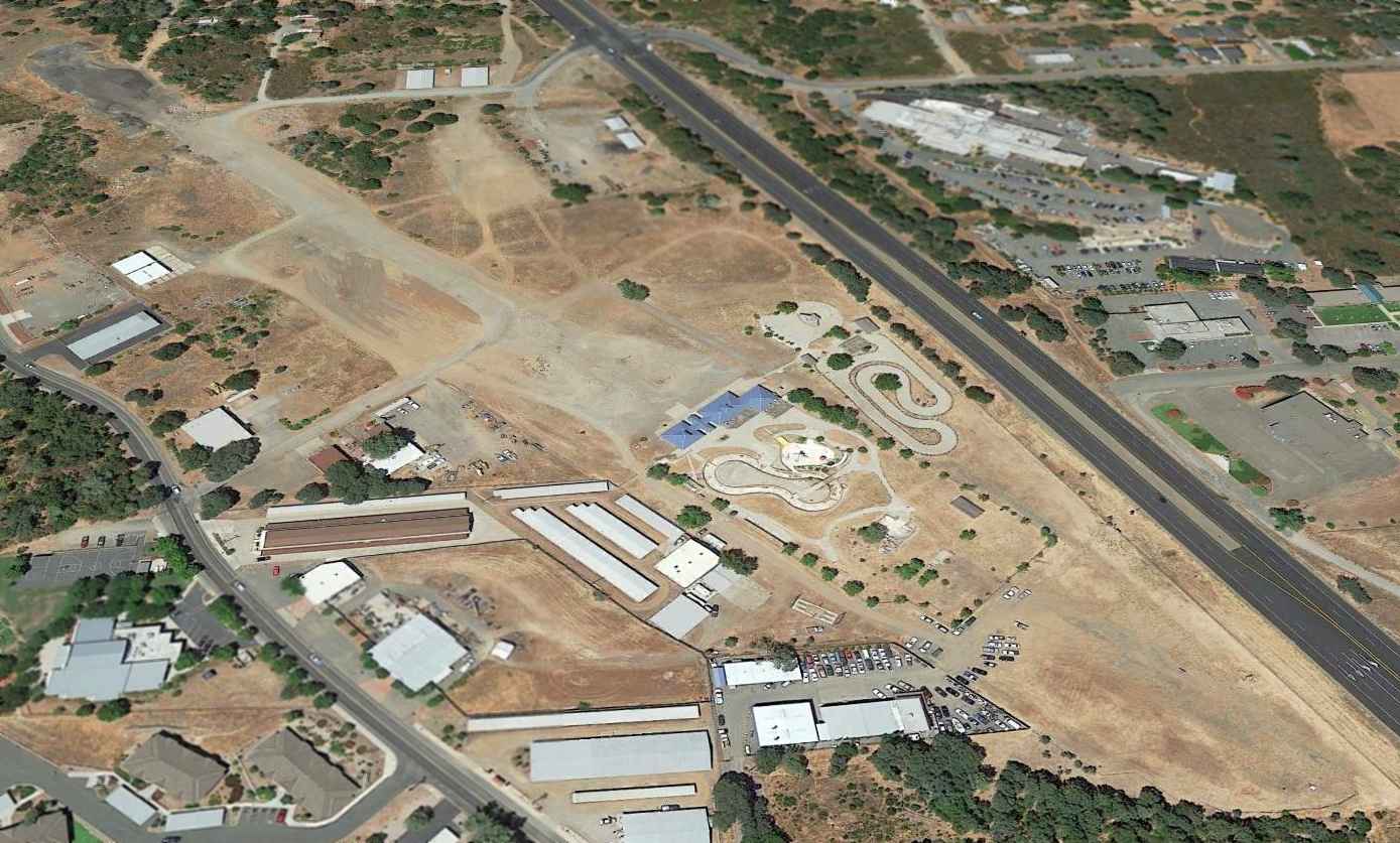
AvAg Heliport, Hamilton City, CA
39.747, -122.017 (Northeast of San Francisco, CA)
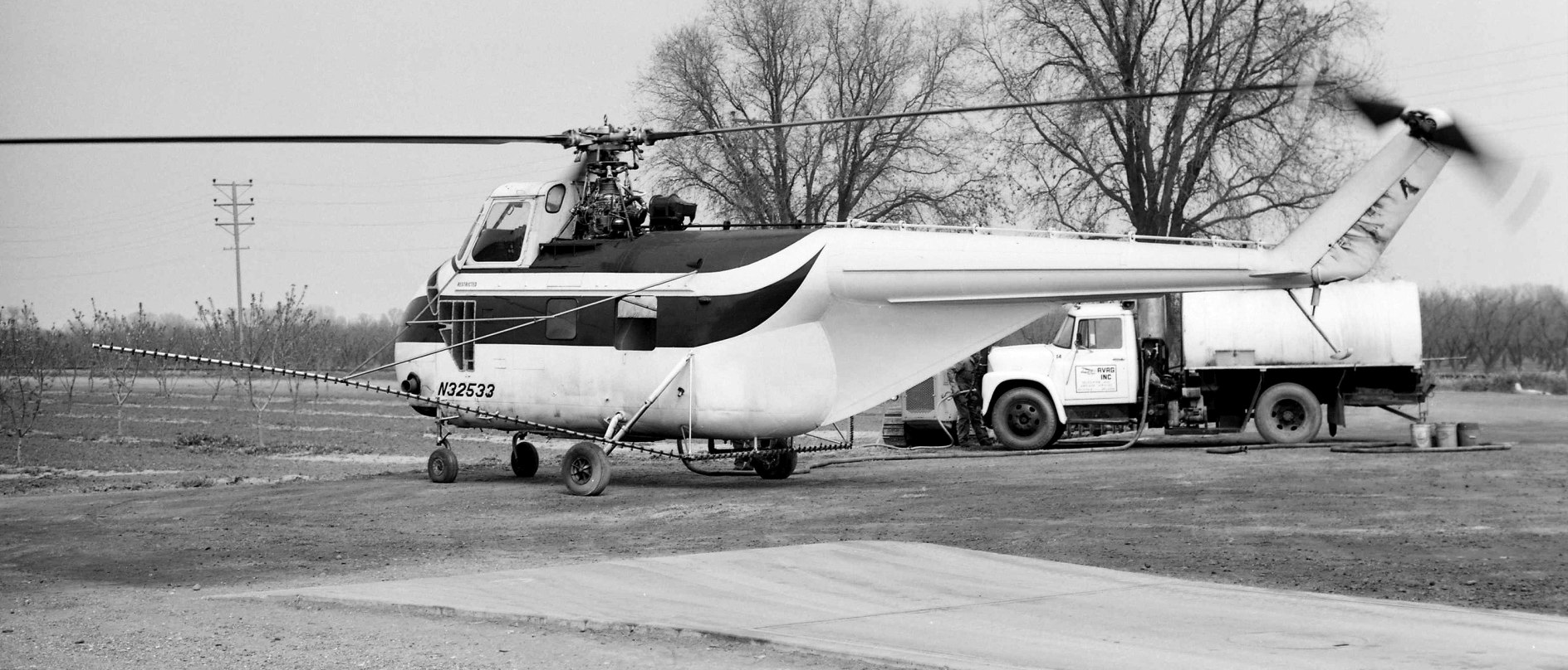
A March 1976 photo by Jay Sherlock of Sikorsky UH-19D N32533 at the AvAg Hamilton City Heliport.
This small private heliport was evidently established at some point between 1969-76, as it was not yet depicted on a 1969 aerial photo.
No heliport was depicted at this location on the 1970 USGS topo map or the 1971 San Francisco Sectional Chart.
Jay Sherlock recalled, “There was a heliport at Hamilton City operated by AvAg.
So far as I can determine is was not an official field (it wasn't shown on any of the Sectionals I have), but I know it was in use for several years.
It was a compacted dirt & concrete area behind some agricultural sheds for aircraft & vehicle parking/refueling.
The pad area was reached by driving north from the highway past a large corrugate-sided shed with a covered but open-sided canopy area.
The earliest depiction which has been located of the AvAg Hamilton City Heliport was a March 1976 photo by Jay Sherlock of Sikorsky UH-19D N32533.
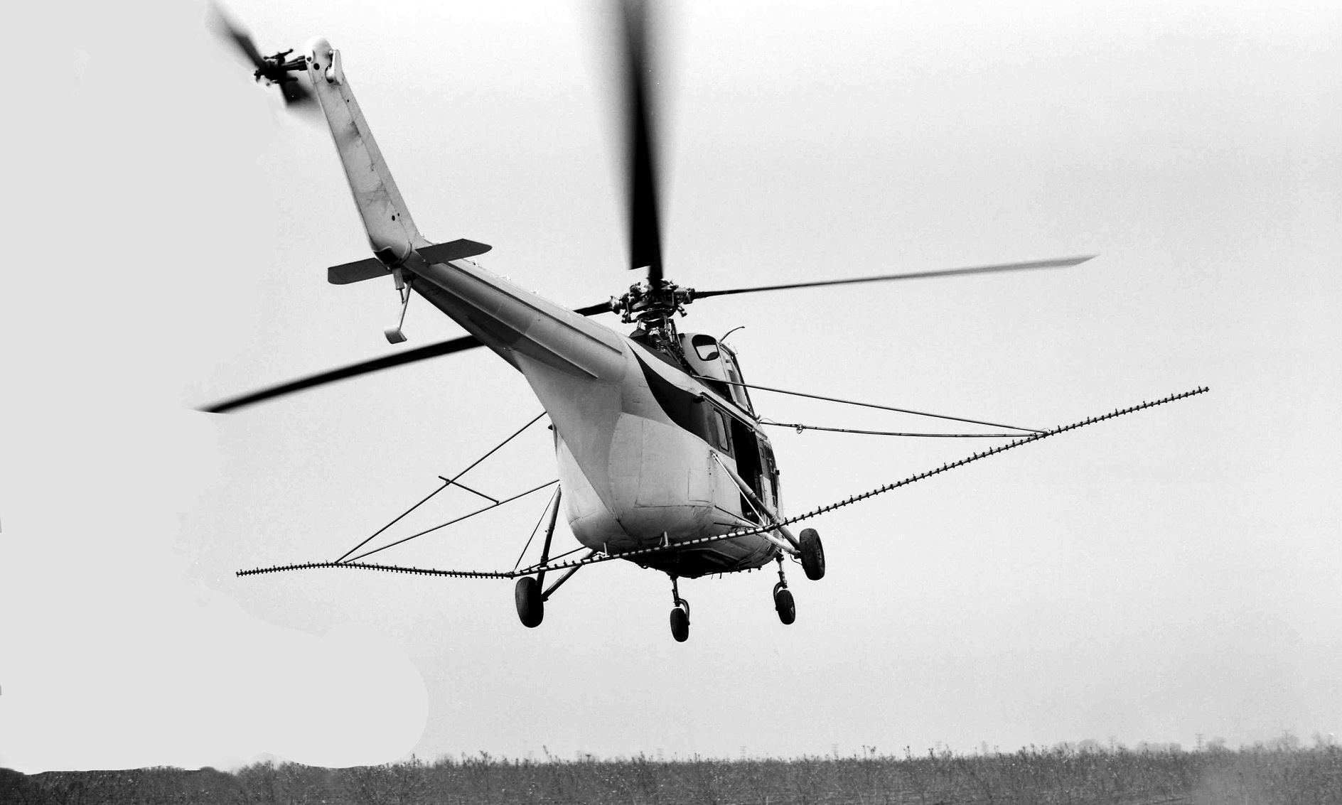
A March 1976 photo by Jay Sherlock of Sikorsky UH-19D N32533 departing from the AvAg Hamilton City Heliport.
No heliport was depicted at this location on the 1979 USGS topo map.
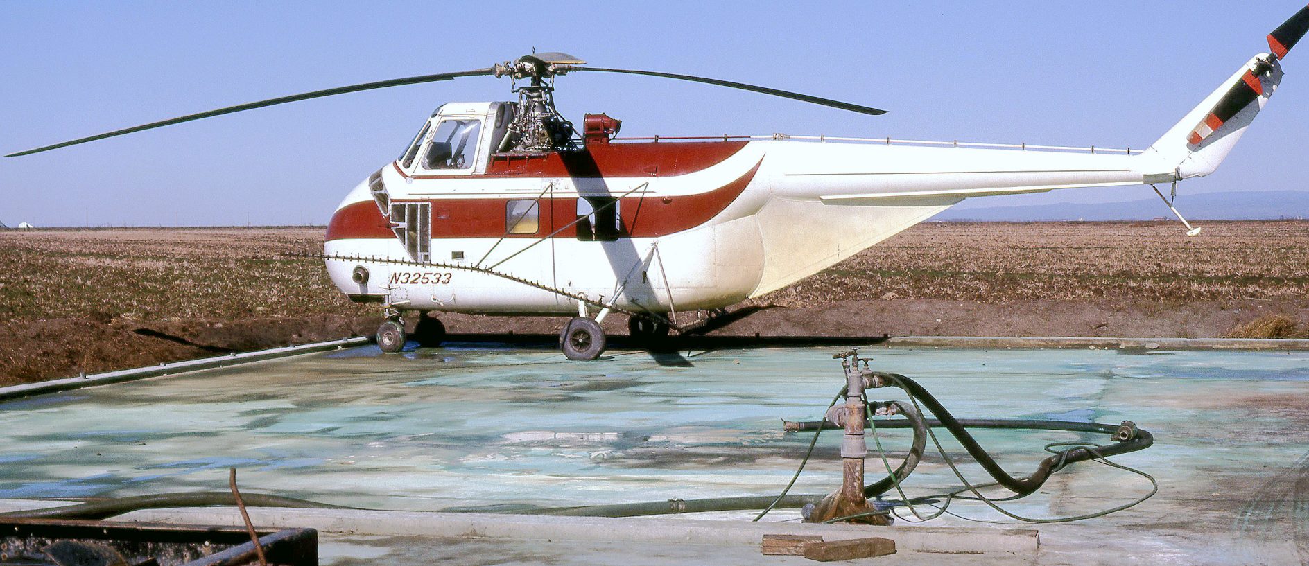
The last depiction which has been located of the AvAg Hamilton City Heliport was a May 1980 photo by Jay Sherlock of Sikorsky UH-19D N32533.
No heliport was depicted at this location on the 1993 San Francisco Sectional Chart.
A 2005 aerial photo showed the area of the AvAg Hamilton City Heliport was still clear, but without any sign of recent aviation use.
A 2009 aerial photo showed several buildings had been built over the site of the AvAg Hamilton City Heliport at some point between 2005-2009.
No heliport was depicted at this location on the 2012 USGS topo map.
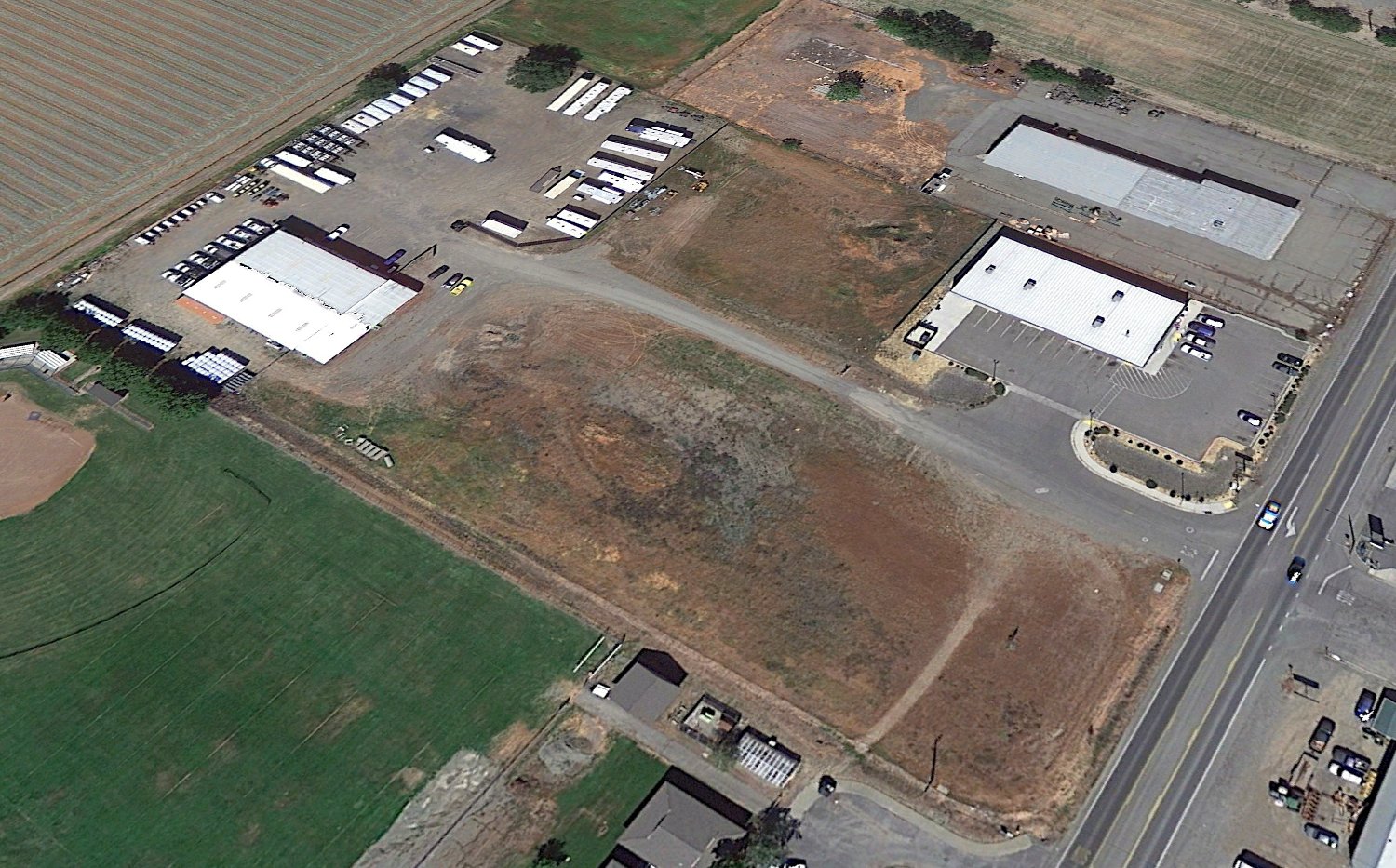
A 2021 aerial view looking northeast showed several buildings on the site of the AvAg Hamilton City Heliport.
Thanks to Jay Sherlock for pointing out this airfield.
____________________________________________________
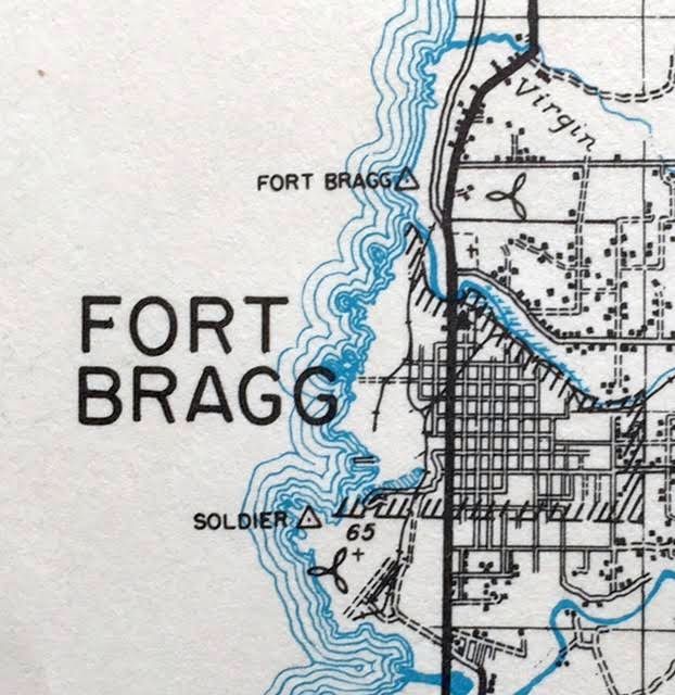
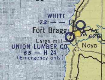
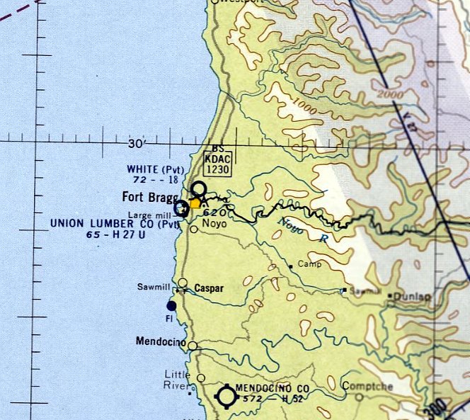
Fort Bragg Airport (original location) / White Airport, Fort Bragg, CA
39.462, -123.801 (Northwest of San Francisco, CA)
Ft Bragg Airport, as depicted on the 1929 Landing Fields of the Pacific West chart (courtesy of Jonathan Westerling).
Photo of the airport while in operation is not available.
The date of establishment of this small general aviation airport along the northwest CA coast has not been determined.
The earliest depiction which has been located of Ft Bragg Airport was on the 1929 Landing Fields of the Pacific West chart (courtesy of Jonathan Westerling).
It described Ft Bragg as a commercial airport, operated by Lee Wilson & C.R. Weller.
It was described as having a 2,075' scraped northwest/southeast runway.
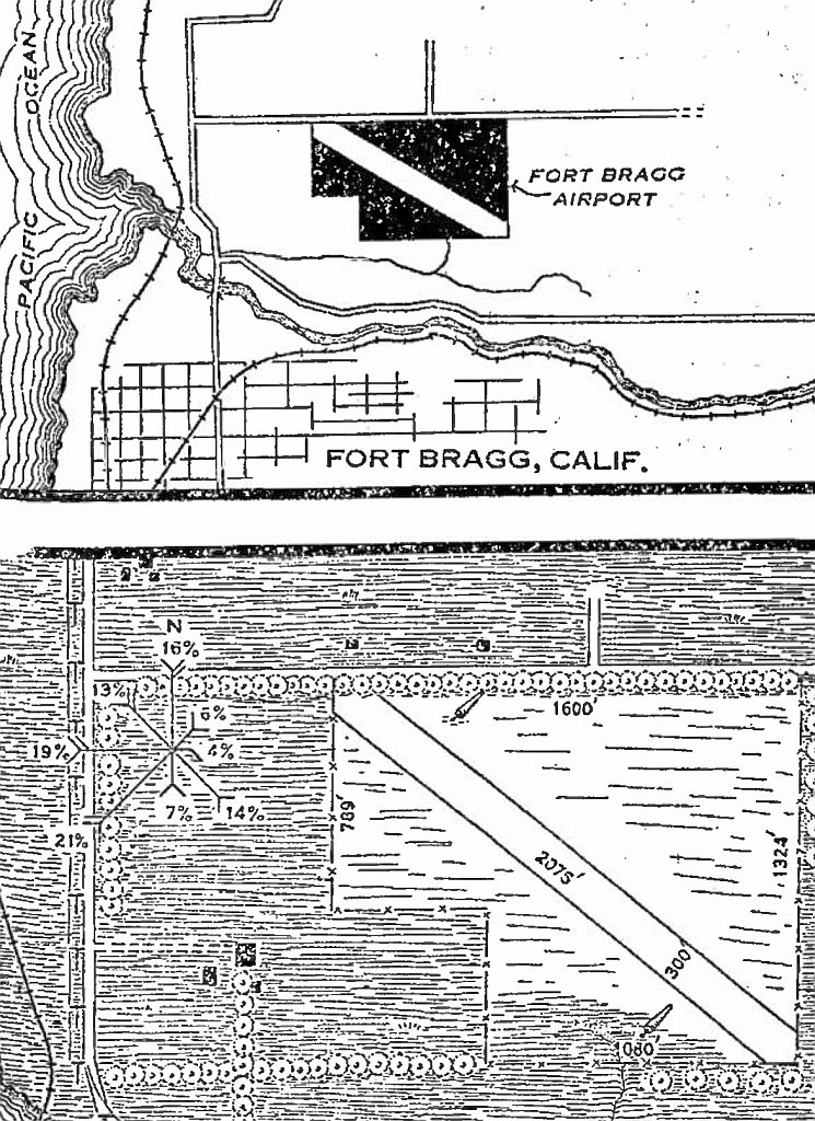
The location & layout of Ft Bragg Airport, as depicted on the 1/16/31 Commerce Department Airway Bulletin (courtesy of Jonathan Westerling).
It described Ft Bragg as a commercial airport, owned & operated by Lee Wilson & C.R. Weller.
It was described as a 43 acre rectangular property, having a 2,075' sod northwest/southeast runway.
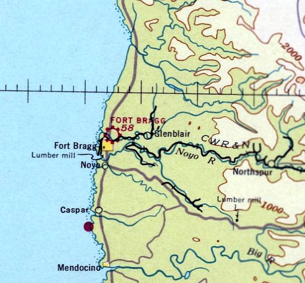
The earliest aeronautical chart depiction which has been located of Ft Bragg Airport was on the May 1936 Sacramento Sectional Chart.
According to Jonathan Westerling, “Gertrude White bought the property in 1936 while it still had the airfield on it.
She split from her husband in 1939 but retained the property as a dairy.
Evidently the divorce is when the first iteration of the airfield came to an end.”
The last aeronautical chart depiction which has been located of this original location of Ft Bragg Airport was on the February 1939 Sacramento Sectional Chart.
Ft Bragg Airport was evidently closed at some point between 1939-41,
as it was no longer depicted on the November 1941 Sacramento Sectional Chart.
According to Jonathan Westerling, “An article in the 10/23/46 Ukiah Republican explained that at that time Gertrude White leased the land to an FBO, which explains why the airfield 'reappeared' after WWII.”
The article read, “New Flying Field. Fort Bragg now has a flying service! It is located Just north of the city on the White Airfield & will be called the Kimbley Flying Service.
The new company is leasing White Airport from Gertrude White & will start construction of an 8-place hangar immediately.
Gas facilities will be installed & 1 airplane & engine mechanics will be on the field at all times. Bill Young Is associated as flight instructor & airplane & engine mechanic.
A runway Is being graded this week & taxi strips will be put in as soon as possible. Student Instruction has started & 5 local men are taking lesions.
Competent instructors give lessons In flying for all ratings & guarantee licenses to those completing the training period.
Plans call for chartered trips to any place In the US & the delivery of freight."
Ft Bragg Airport was not depicted on the February 1947 Sacramento Sectional Chart.
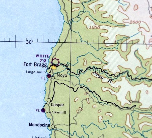
At some point in 1947 the original Ft Bragg Airport was evidently reopened as White Airport,
as that is how it was depicted on the August 1947 Sacramento Sectional Chart.
White Airport, as depicted (by the propeller symbol at top-right) on a 1948 CA Forestry Division map (courtesy of Kevin Walsh).
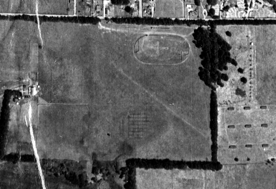
The only photo which has been located showing White Airport in operation was a 1948 aerial view.
It depicted White Airport as having a single unpaved northwest/southeast runway,
with a few small buildings & 1 light single-engine aircraft along the north side.
An oval racetrack was adjacent to the northeast side of the runway.
The March 1954 USAF Sacramento Sectional Chart (courtesy of Chris Kennedy) depicted White Airport as having a mere 1,800' unpaved runway.
The last aeronautical chart depiction which has been located of White Airport was on the September 1960 Sacramento Sectional Chart.
Bryan McCleve reported, “I asked a volunteer at the Fort Bragg Museum why a street in Fort Bragg is called Airport Road.
He said there was an airport there; he even took some flying lessons there.”
White Airport was not depicted on the 1962 USGS topo map, but ironically the map did label the adjacent road as Airport Road.
A 1963 aerial view (courtesy of Jonathan Westerling) showed White Airport as remaining intact, with the northwest/southeast runway still recognizable,
and 1 T-hangar still on the north side, but there were no aircraft visible on the field.
White Airport was evidently closed at some point between 1960-65,
as it was no longer depicted on the June 1965 Sacramento Sectional Chart.
Instead it depicted another Fort Bragg Airport which had been established less than a mile to the northeast.
A 1998 aerial photo showed no trace remaining of White Airport.
According to Jonathan Westerling, “The property narrowly escaped being developed into 280+ condos in 2006 having been purchased by developers after Gertrude White's death.
According to press reports, the bank sold the foreclosed land to the Potter Valley Band of Pomo Indians in 2009.”
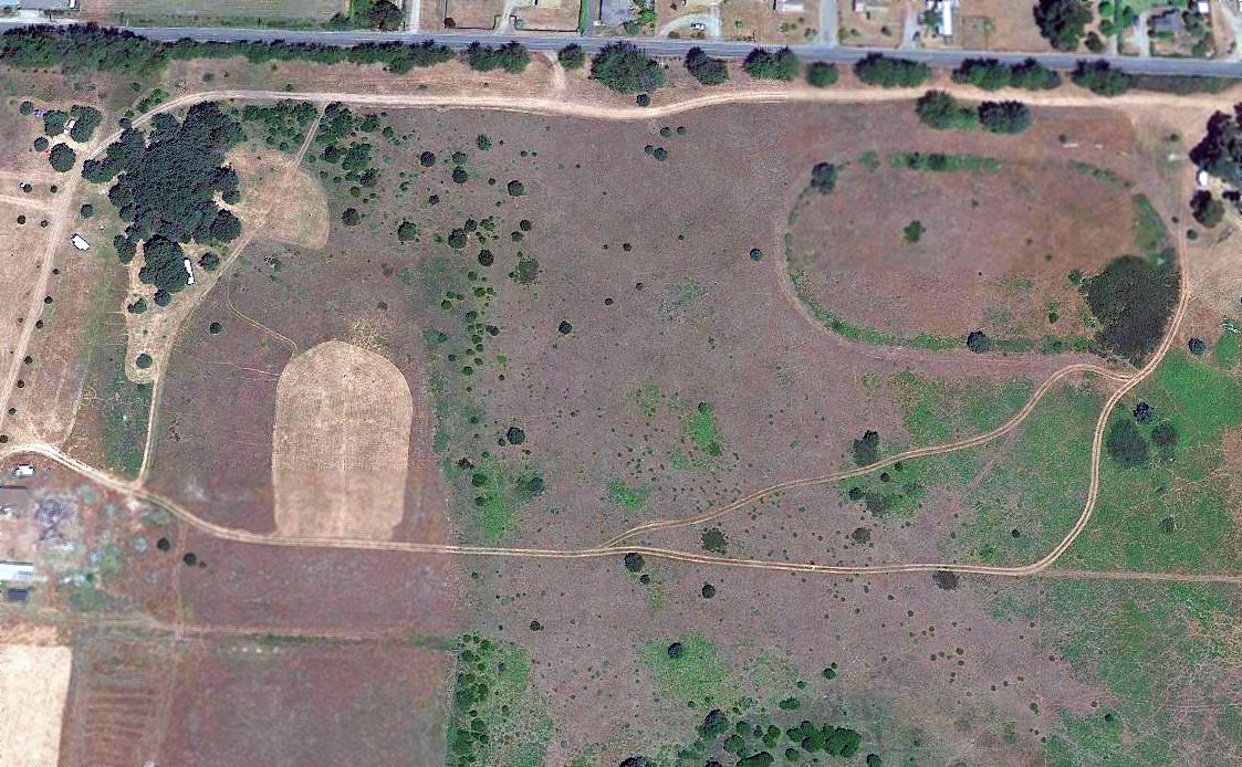
A 2018 aerial photo showed no trace remaining of White Airport, but the remains of the adjacent oval racetrack were still plainly recognizable.
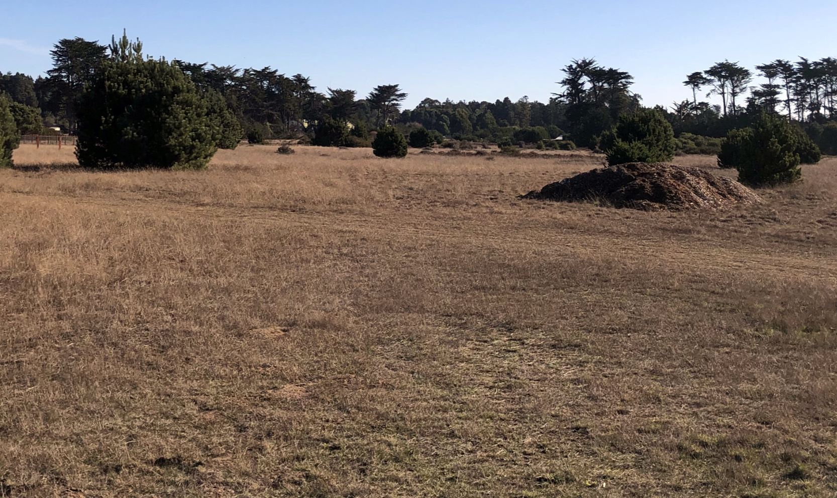
An 11/26/20 photo by Jonathan Westerling looking southeast showed no trace remaining of White Airport.
Jonathan Westerling reported in 2020, “It is now called the Noyo-bida Ranch & used for tribal activities, though there's nothing preventing the tribe from attempting to develop the land in the future.”
Thanks to Bryan McCleve for pointing out this airfield.
____________________________________________________
Point Arena Hotel Airfield, Point Arena, CA
38.93, -123.71 (Northwest of San Francisco, CA)
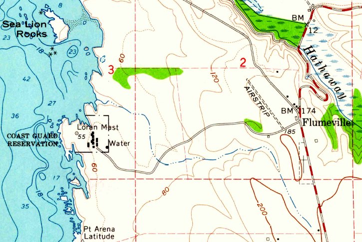
The Point Arena Hotel Airfield, as depicted on the 1960 USGS topo map (courtesy of Chuck Ross).
The Point Arena Hotel Airfield was not yet depicted on the August 1948 Sacramento Sectional Chart (courtesy of Ron Plante).
The Point Arena Hotel Airfield was given California airport Permit 23-6, given out in 1949 (according to a paper record from the San Francisco Airport Aviation Library, via Jonathan Westerling).
The 1949 CA Air Chart (according to Jonathan Westerling) listed the owner of the Point Arena Hotel Airfield as North Coast Resorts.
The 1951 Directory of Airfields (according to Jonathan Westerling) described Point Arena Hotel Airfield as having a 1,300' runway.
The 1967 Airports USA Directory (according to Jonathan Westerling) described Point Arena Hotel Airfield as having a Runway 13/31.
According to nearby resident Chuck Ross, “I remember back in the 1950s when it was in use.
The T-hangar on the north end had no siding in the east side & no doors, so I could see a ragwing taildragger parked there.”
The Point Arena Hotel Airfield was not depicted on the 1958 USGS topo map.
The earliest depiction which has been located of the Point Arena Hotel Airfield was on the 1960 USGS topo map.
It depicted a single unpaved northwest/southeast runway, generically labeled as “Airstrip”, with a small building on the southeast corner.
The earliest photo which has been located of the Point Arena Hotel Airfield was a 6/30/63 USGS aerial view.
It depicted the Point Arena Hotel Airfield as a single unpaved northwest/southeast runway, with a small building on the southeast corner.
The earliest aeronautical chart depiction which has been located of the Point Arena Hotel Airfield was on the 1967 Sacramento Sectional Chart.
It depicted the Point Arena Hotel Airfield as a private airfield having a mere 1,500' unpaved runway.
The Point Arena Hotel Airfield was evidently closed (for reasons unknown) at some point between 1967-71,
as it was no longer depicted on the November 1971 San Francisco Sectional Chart (courtesy of Ron Plante).
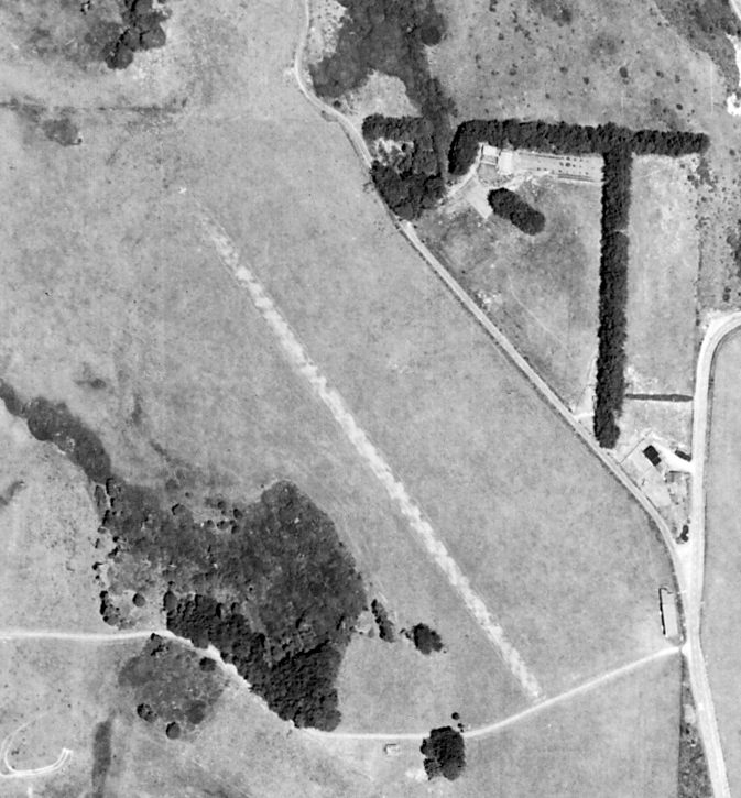
A 1983 USGS Aerial Photo (from UCSB, courtesy of Jonathan Westerling) showed the Point Arena Hotel Airfield & its hangar still intact,
though it hadn't been listed in any airport directories for over a decade.
The Point Arena Hotel Airfield continued to be depicted in an unchanged fashion on the 1985 USGS topo map.
A 2003 aerial view looking north at the site of the Point Arena Hotel Airfield showed the runway area remained clear,
and the hangar remained standing at the southeast corner.
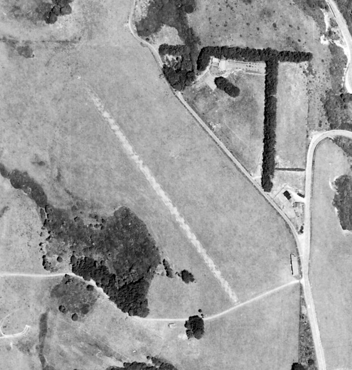
A 2004 aerial view showed the Point Arena Hotel Airfield hangar had evidently been removed at some point between 2003-2004.
The 2012 USGS topo map no longer depicted the Point Arena Hotel Airfield.
A 2013 aerial view looking north at the site of the Point Arena Hotel Airfield showed the runway area remained clear,
and the hangar foundations remained at the southeast corner.
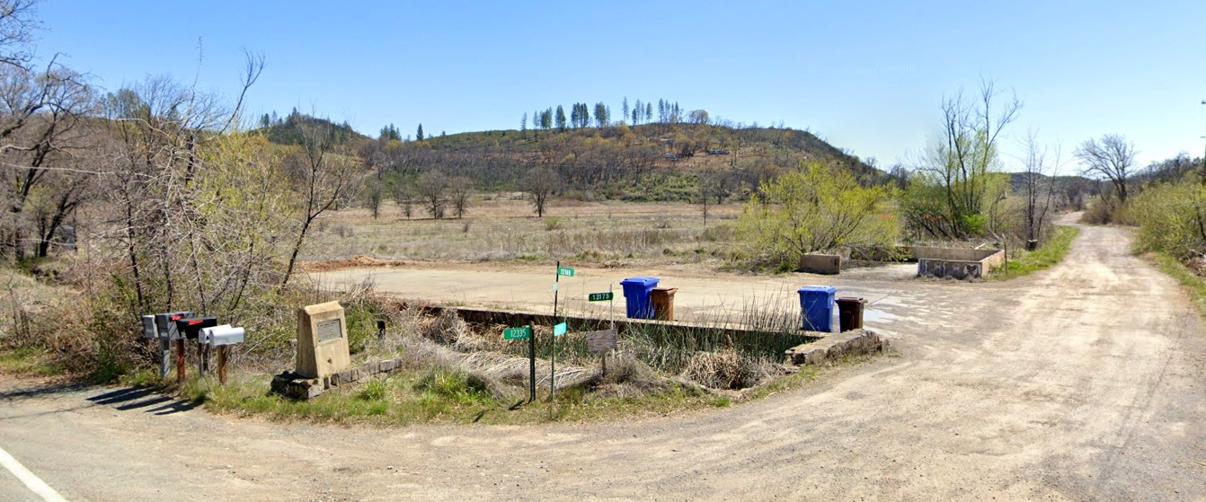
A 4/16/19 drone aerial view by Chuck Ross looking northwest at the site of the Point Arena Hotel Airfield.
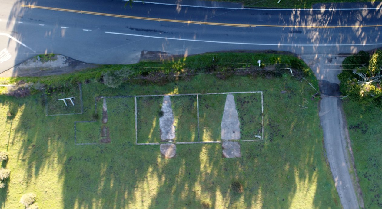
A 4/17/19 drone aerial view by Chuck Ross looking east at the Point Arena Hotel Airfield hangar foundations.
Chuck observed, “Note that the concrete pads are for a tailwheel configuration. California Highway 1 is across the top.
The road running out the lower-right corner is now a public walking trail, formerly the road to the Point Arena LORAN station.”
An 8/21/19 photo by Rick Beach (courtesy of Ken Mercer) looking north at the Point Arena Hotel Airfield hangar foundations, visible through the property gate.
Rick noted that the property is now part of the Point Arena-Stornetta Unit of the California Coastal National Monument.
Thanks to Kevin Walsh for pointing out this airfield.
____________________________________________________
39.704, -121.81 (Northeast of San Francisco, CA)
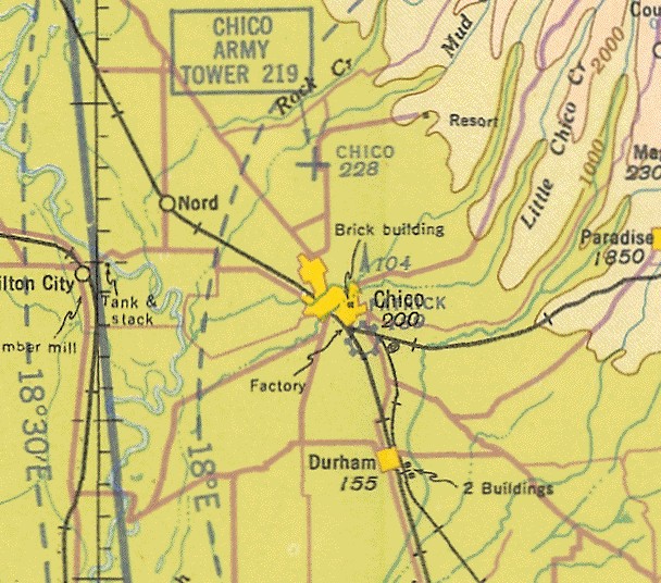
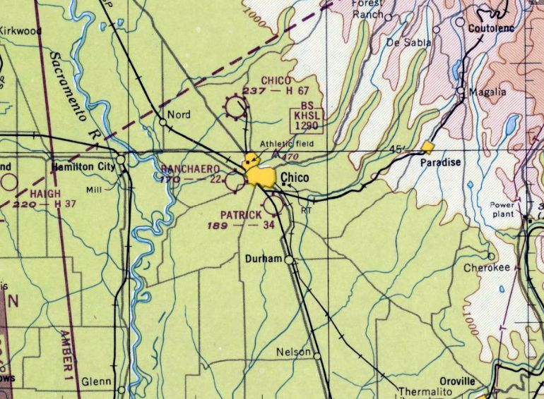
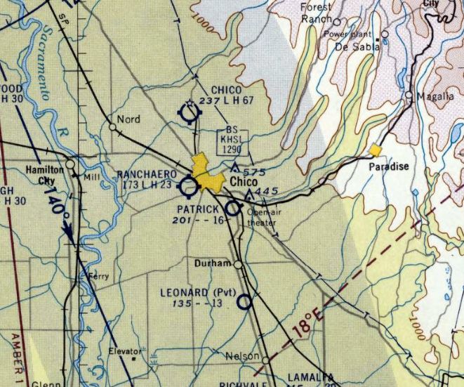
Patrick Field, as depicted on the May 1936 Sacramento Sectional Chart.
According to Sandy Hill of the the Patrick Ranch Museum, “Patrick Airport was the first airport in Chico CA. It opened in 1924 & was the 4th airfield to open in California
Patrick Field became an officially recognized airport in 1929
William Garrison Patrick built Patrick Field in 1929 for private planes & small-scale commercial flying, and it was dedicated in 1930.
He had asked his father if he could build an airport on the property. He was in his early twenties & extremely interested in flying.
It began commercial training & was designed by the Civil Aeronautics Authority as a field for commercial flying, private [pilot] licenses [were] also issued.
At one time there were 2 hangars that held 12 planes.
He had the electrical wires at the end of the runway underground, only for that portion of the field.
William Garrison Patrick thought he would have a subdivision just off of Patrick Field & 2 streets were named Cessna Avenue & Skyway Avenue.
The idea was that you could park your plane in your driveway…that didn’t happen.”
The earliest depiction which has been located of Patrick Field was on the May 1936 Sacramento Sectional Chart,
which depicted Patrick as a commercial/municipal airport.
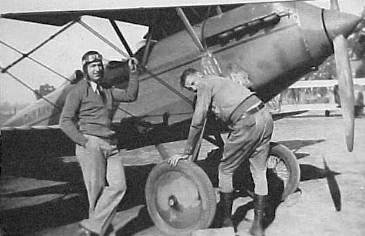
The earliest photo which has been located of Patrick Field was a circa 1930s photo of Eddie Jillson & “Pat” Patrick in front of an Travel Air OX5 biplane.
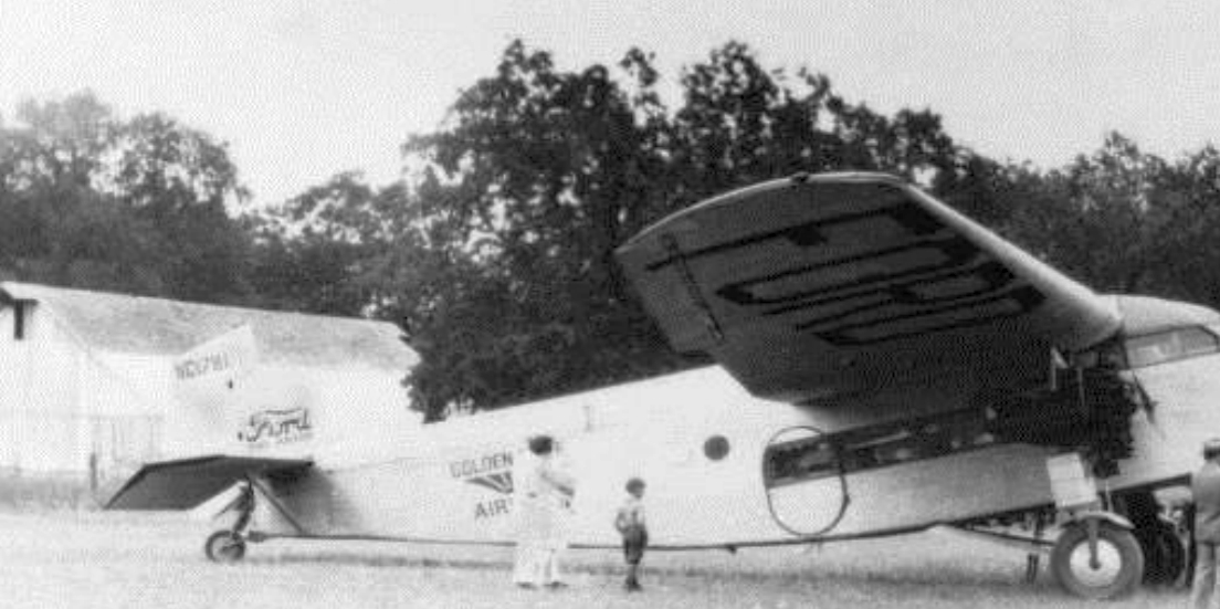
A circa 1930s photo of a Ford TriMotor at Patrick Field.
Patrick Field was evidently closed at some point between 1936-37,
as it was no longer depicted on Sacramento Sectional Charts from April 1937 – November 1941.
A 1941 aerial view depicted Patrick Field as having a single unpaved northwest/southeast runway, with a small building on the east side.
Patrick Field was evidently reopened at some point between 1941-42,
as it was once again depicted as a commercial/municipal airport on the September 1942 Sacramento Sectional Chart.
According to Sandy Hill, “Patrick Field was closed during the war [WW2].”
Patrick Field was evidently closed again at some point between 1942-43,
as it was no longer depicted on the August 1943 Sacramento Sectional Chart.
Patrick Field was evidently reopened again at some point between 1943-44,
as it was once again depicted as a commercial/municipal airport on the April 1944 Sacramento Sectional Chart.
According to Sandy Hill, “After the war I believe the airport was used for crop dusters, but I am not sure that was in business very long.”
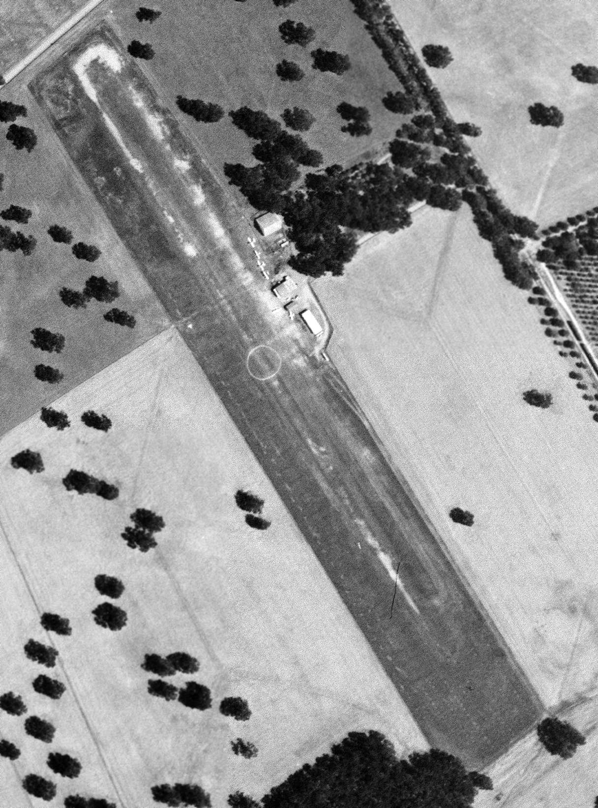
The last photo which is available showing aircraft at Patrick Field was a 6/13/47 USGS aerial view.
It depicted Patrick Field as having a single unpaved northwest/southeast runway, with 5 light single-engine aircraft visible near a few small hangars on the east side.
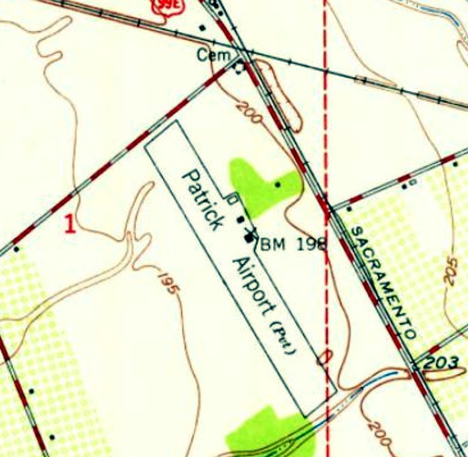
The only topo map depiction which has been located of Patrick Field was on the 1948 USGS topo map.
It depicted “Patrick Airport (Pvt)” as having a single northwest/southeast runway, with 3 small buildings on the east side.
The February 1948 Sacramento Sectional Chart depicted Patrick Field as having a 3,400' unpaved runway.
The last aeronautical chart depiction which has been located of Patrick Field was on the September 1957 Sacramento Sectional Chart.
It depicted Patrick Field as having a mere 1,600' unpaved runway.
Patrick Field was evidently closed again at some point between 1957-58,
as it was no longer depicted on the April 1958 Sacramento Sectional Chart or subsequent Sectionals.
The last photo which has been located showing aircraft at Patrick Field was a 1958 aerial view.
The northwestern 1,400' of Patrick Field's runway remained, along with several hangars, but the southeastern portion of the runway had reverted to farmland.
One single-engine aircraft was visible parked near the hagars.
A 1969 aerial view showed the northwestern 1,400' of Patrick Field's runway remained, along with 2 hangars, but no aircraft were visible on the field.
Patrick Field was not depicted on the November 1971 San Francisco Sectional Chart.
However, Patrick Field evidently continued to see some aviation use (perhaps in an unofficial capacity),
as Curtis Marzolf recalled, “I lived at the airport from 1972-82. There was some private aircraft & ultralight activity there until at least then.
We had a Piper Cub & a Cessna 152 that were regularly flown off the strip. The crop duster there at the time was Bob Krajcirik - Kracker Jack Aviation.
My parents had a flying service for a short time. As far as I knew the strip had always ended a little south of the southern hangars.
We flew off it quite a bit, along with the AgCat pilot. It was 1,400' or so when we left.
The bus dropped me off at the end, and it was a pretty good walk for a 9 year old.
It was a neat place to grow up. I always thought it was weird to take off over the oil tanks along Hegan Lane.”
According to Sandy Hill, “During the 1970s the Civil Air Patrol was housed at Patrick Field.”
Patrick Field was not depicted on the April 1989 San Francisco Sectional Chart.
According to Sandy Hill, Patrick Field “was in operation until 1990.”
A 1998 aerial view showed the northwestern half of Patrick Field's runway had been covered by a cemetery, but the 2 former hangars remained standing.
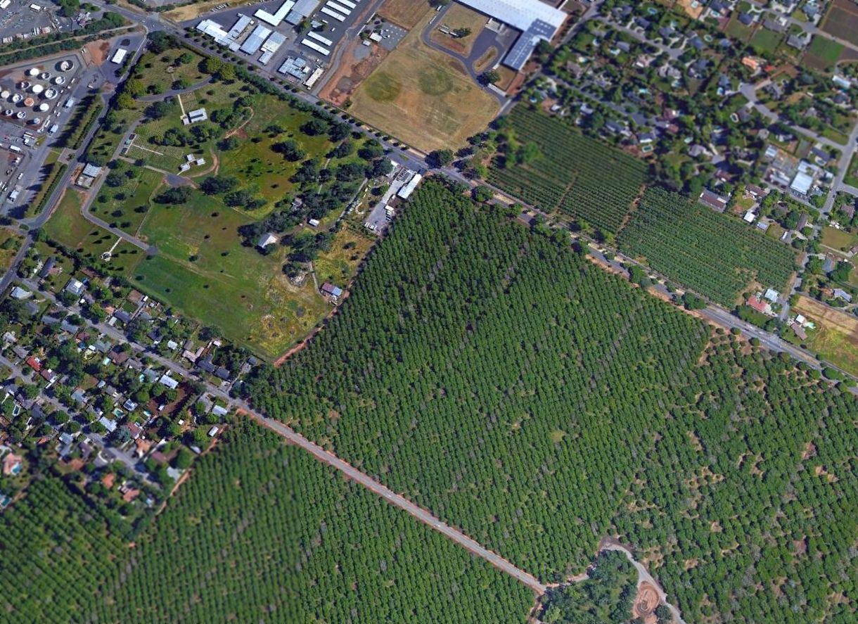
A 2016 aerial view looking northeast at the site of Patrick Field shows 2 hangars remain standing, although no trace remains of the runway.
Sandy Hill reported in 2017, “Cessna Avenue & Skyway Avenue... people living on those streets today have a clause in their deed that states they can park a plane in their driveway.”
Former Patrick Field resident Curtis Marzolf reported in 2017, “Our house, along with the large Quonset-style hangar & the grain bins are no longer there.”
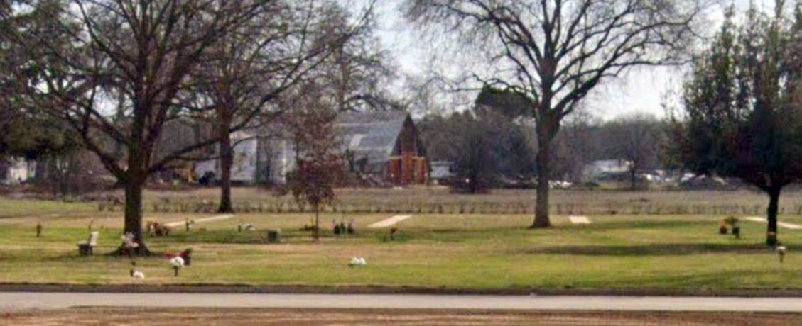
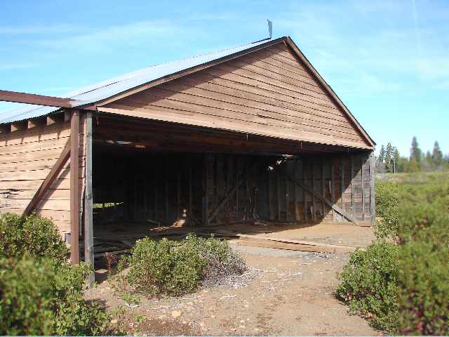
A 2021 photo looking southeast at one of the two former hangars which remains at the site of Patrick Field.
The site of Patrick Field is located east of the intersection of Skyway Avenue & Hegan Lane.
Thanks to Sandy Hill for pointing out this airfield.
____________________________________________________
40.44, -122.29 (North of San Francisco, CA)
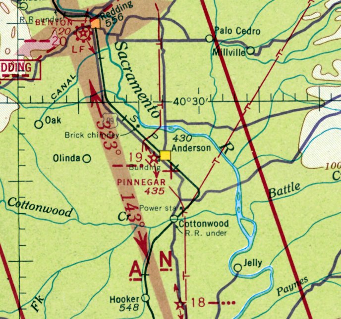
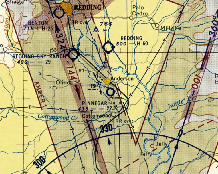
Pinnegar Field, as depicted on the January 1942 Mt Shasta Sectional Chart.
Fred G. Pinnegar recounted in his book “Born to Fly” (courtesy of Fred Pinnegar III),
in June 1930, “I had experienced a 'dead stick' landing on what had been a race track just east of Anderson.
I thought the area where I had landed would be a suitable place to keep my plane.
I found out that the land was owned by George Barney, who also owned the Anderson ice plant & butcher shop.
We agreed on a price for about 20 acres, which I could buy for $20/month.
Having bought the land, I now needed a hangar to keep the plane in.
Grandfather Welch came down from Dunsmir & between us we built a T-shaped hangar, a little over 40' wide.
I bought aviation gas from Standard Oil, and they put up an airport windsock on the hangar for me.
The field eventually became 'Pinnegar Field' & was listed on all aviation charts & maps for the area.”
Pinnegar Field was not yet depicted on the January 1937 Mt Shasta Sectional Chart.
The Airport Directory Company's 1937 Airports Directory (courtesy of Bob Rambo)
described Pinnegar as an auxiliary airfield having a rectangular gravel field measuring 2,250' x 1030'.
A hangar was said to be marked with “ANDERSON” on its roof.
The earliest depiction which has been located of Pinnegar Field was on the January 1942 Mt Shasta Sectional Chart,
which depicted Pinnegar as an auxiliary airfield.
The 1945 AAF Airfield Directory (courtesy of Scott Murdock) did not include a listing for Pinnegar Field.
The 1948 Mt Shasta Sectional Chart (courtesy of Chris Kennedy) depicted Pinnegar Field as having a 2,300' unpaved runway.
According to the book “Born to Fly” by Fred G. Pinnegar (courtesy of Fred Pinnegar III),
on 9/30/49 Pinnegar Field was “issued an airport permit by the State of CA.”
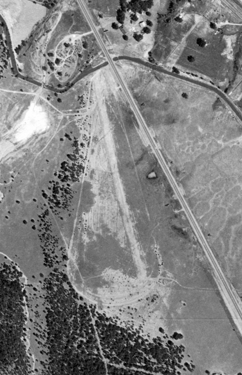
The only photo which has been located of Pinnegar Field was a 7/14/52 USGS aerial view.
It depicted Pinnegar Airfield as having a single northwest/southeast unpaved runway.
But it is not evident if the airfield was still in use by this point, as there were no buildings or aircraft visible on the field.
The last depiction which has been located of Pinnegar Field was on the March 1955 Mt. Shasta Sectional Chart.
It depicted Pinnegar Airfield as having a 2,300' unpaved runway.
Fred G. Pinnegar recounted in his book “Born to Fly” (courtesy of Fred Pinnegar III),
“I sold the airport property in 1955 to a developer in Anderson.”
Pinnegar Field was no longer depicted on the March 1960 Mt Shasta Sectional Chart.
Fred G. Pinnegar recounted in his 2005 book “Born to Fly” (courtesy of Fred Pinnegar III),
the site of Pinnegar Field “is now covered with houses.”
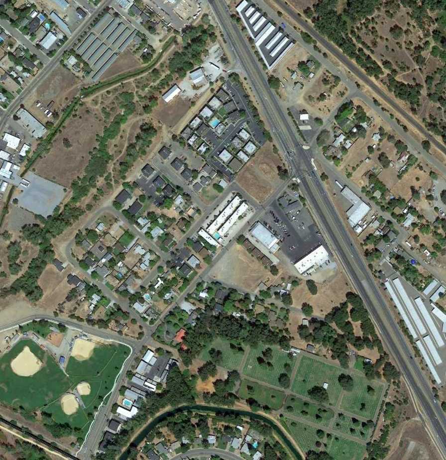
A 2013 aerial view shows no trace remaining of Pinnegar Field.
The site of Pinnegar Field is located roughly west of the intersection of Route 273 & Pinon Avenue.
Thanks to Fred Pinnegar for pointing out this airfield.
____________________________________________________
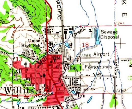
(Original) Willits Airport, CA, Willits, CA
39.41, -123.34 (Northwest of San Francisco, CA)
Willits Airport, as depicted on the February 1947 Sacramento Sectional Chart.
The original airport for the town of Willits was located in the northeast portion of the town.
Willits Airport was not yet depicted on the September 1946 Sacramento Sectional Chart.
According to current Willits Airport manager Dan Ramsey, the original Willits Airport was “built about 1947.”
The earliest depiction which has been located of Willits Airport was on the February 1947 Sacramento Sectional Chart.
Chuck Ross recalled, “The old Willits downtown airport... I had my first airplane ride out of Willits in about 1949 in a Piper Clipper.
The pilot was Wilbur 'Andy' Anderson & I am quite sure that he was the 'Andy' of Andy’s Aircraft Sales at Coddingtown Airport.
A Southwest Airways DC-3 landed there in the 1940s or early 1950s & had to be stripped down to reduce weight so they could ferry it out to Ukiah.”
Willits Airport was not yet depicted on the 1956 USGS topo map.
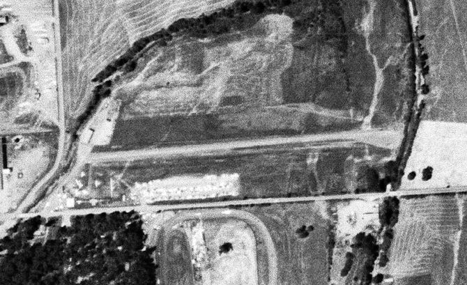
The earliest photo which has been located of Willits Airport was a 7/4/57 USGS aerial view.
It depicted Willits as having an east/west runway, with a few small buildings & several light aircraft on the west side.
According to the book "Cowboys, Loggers, Airports and Airplanes" by Ron Stamps,
Willits Airport was home of the the "Willits Aeronautics Club".
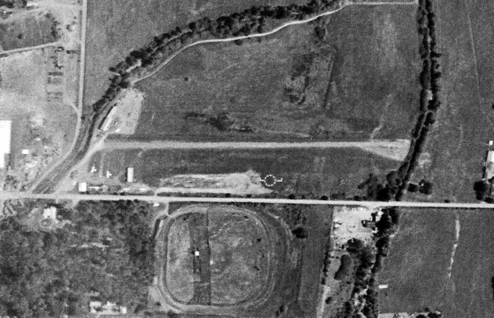
The 1961 USGS topo map depicted Willits as having a single east/west paved runway,
with a few small buildings along the west side.
The last depiction which has been located of Willits Airport was a 6/12/64 USGS aerial view.
A half-dozen single-engine aircraft were visible parked to the southwest of the runway.
According to the book "Cowboys, Loggers, Airports and Airplanes" by Ron Stamps,
the post-war boom would eventually spell the demise of Willits Airport's in-town location.
The last aeronautical chart depiction which has been located of the original Willits Airport was on the September 1960 Sacramento Sectional Chart.
It depicted Willits Airport as having a mere 1,800' unpaved runway.
The replacement Ells-Willits Airport opened in 1964, farther outside of town to the northwest.
The original Willits Airport was evidently closed by 1965,
as only the Ells-Willits Airport was depicted on the June 1965 Sacramento Sectional Chart.
Willits Airport was still depicted on the 1983 USGS topo map,
even though it had presumably been closed for almost 2 decades by that point.
Willits Airport was no longer depicted on the 1991 USGS topo map.
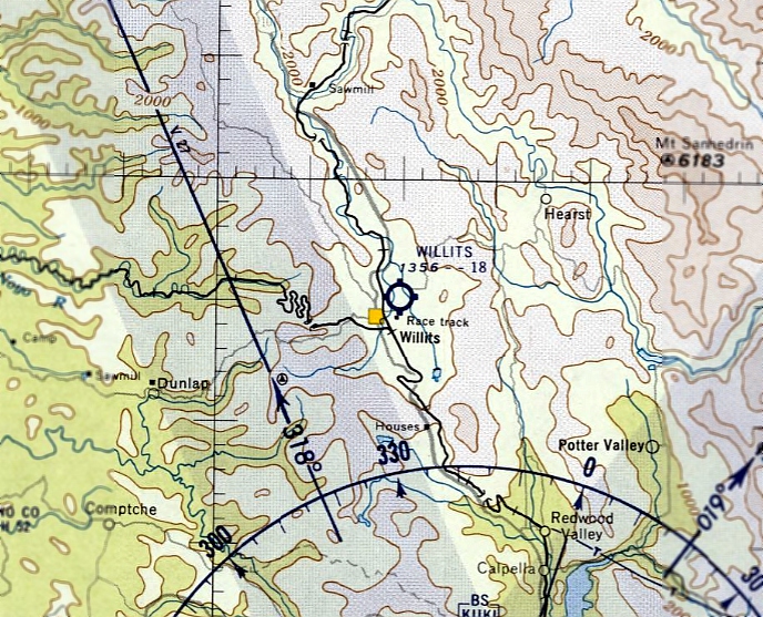
An 8/17/13 aerial view shows no trace remaining of the original Willits Airport, with the site covered by a museum & baseball fields.
The site of Willits Airport is located northeast of the intersection of East Commercial Street & North Lenore Avenue.
Thanks to Bryan McCleve for pointing out this airport.
____________________________________________________
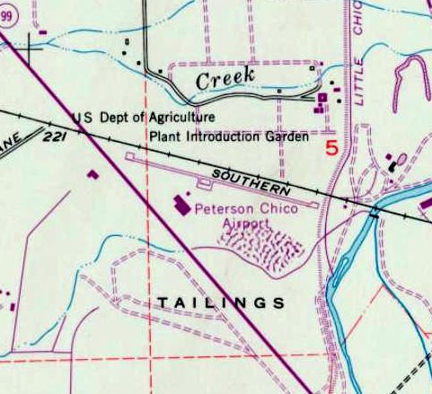
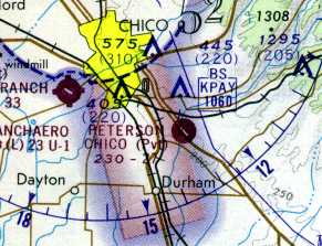
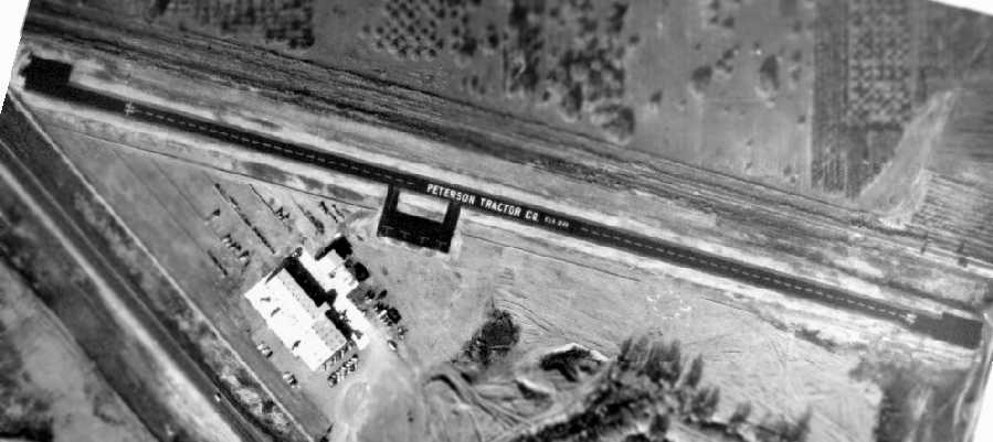
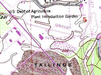
Peterson Chico Airfield (5Q3), Chico, CA
39.703, -121.784 (Northeast of San Francisco, CA)
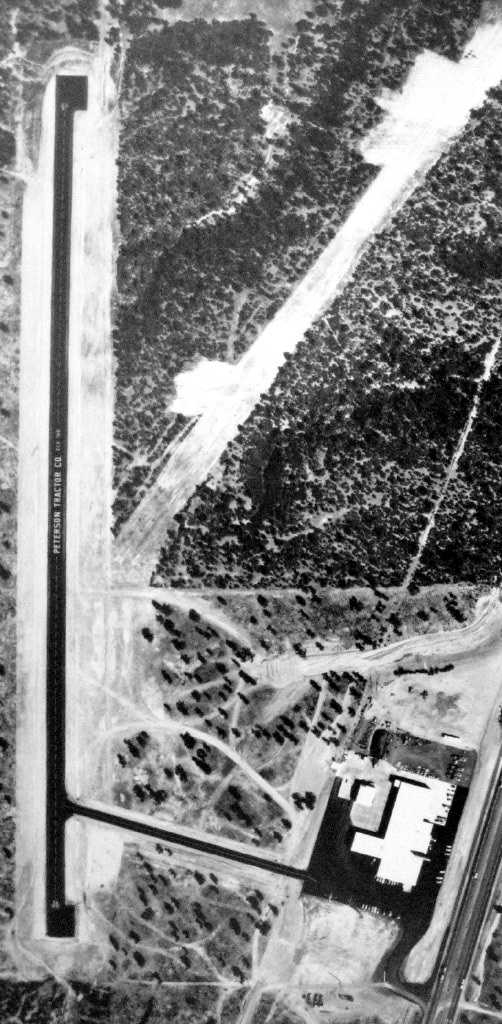
The Peterson Chico Airfield, as depicted on the June 1965 Sacramento Sectional Chart (courtesy of Ron Kunse).
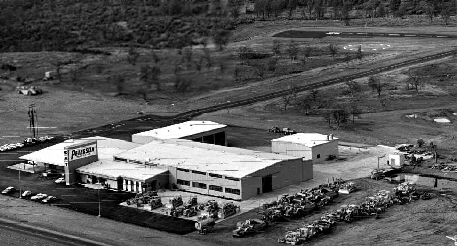
According to Jonathan Westerling, “The Peterson Tractor Company was founded
during the post-depression era of the mid-1930s by Howard Peterson.
The company was incorporated on 11/16/36 as the Caterpillar dealership for the 5 Bay-area counties.
When the company expanded into California’s central valley in 1958,
it became evident that they needed a way to get parts from the Bay area to the vast expanses of Northern California,
and looked to aviation to provide that ability.
Times were different then, and California’s northern central valley was mostly farmland,
so Peterson used some of his Caterpillar tractors to clear, grade & pave his own airports behind his Chico & Redding offices.”
Peterson Chico Airfield was not yet depicted on the September 1960 Sacramento Sectional Chart.
According Eileen Grafton, the Peterson Chico Airfield was built in 1963.
It had no hangar but had an apron for 4 planes next to the runway.
Peterson customers frequently used the airstrip to pick up parts from the Chico store.
Jonathan Westerling reported, “According to Howard Peterson’s grandson Duane Doyle (who is a pilot & also owns & runs the company),
they had 2 planes: a 1955 'T-bone twin' Beechcraft (he thinks it was a B50) & a Cessna 182 from the mid-1960s.
The pilots for the Beech were Bill Gionotti & Dan Derr. The Cessna pilot was Al Mayer.
The Beechcraft was stationed near Peterson’s headquarters in Hayward
and was used to fly company brass up to northern territory & also between the Redding & Chico stores.
The Cessna was based in both Redding & Chico & serviced both locations with parts as needed.”
The earliest depiction which has been located of the Peterson Chico Airfield
was on the June 1965 Sectional Chart (courtesy of Ron Kunse).
It depicted Peterson as a private field having a 2,100' unpaved runway.
The 1967 AOPA Airport Directory (courtesy of Jonathan Westerling)
described Peterson-Chico as having a 2,100' asphalt Runway 11/29.
The 1968 FAA Airport Facilities Record (courtesy of Al Mahr)
described Peterson-Chico as having a 2,573 Runway 10/28.
It listed the owner as Peterson Tractor Company, and the operator as Grant Thompson.
The 1969 USGS topo map depicted the Peterson Chico Airport as having a paved northwest/southeast runway, with turn-around pads on each end,
and a ramp & 2 buildings on the south side.
The last aeronautical chart depiction which has been located of the Peterson Chico Airfield
was on the 1973 Sectional Chart (courtesy of Jonathan Westerling).
It depicted Peterson as a private field having a single 2,700' paved northwest/southeast runway.
According to Jonathan Westerling, “Bill O’Donnell was Peterson’s Northern Stores Manager from 1973-1981.
He was a big fan of the company’s air service.”
Bill observed, “The airplane saved us a lot of time, particularly in the north where there are lots of narrow, winding mountain roads.
We delivered parts many times to people who had breakdowns in remote areas.”
An undated aerial view of the Peterson Chico Airfield which hangs in offices at the company’s Chico & Redding stores (courtesy of Jim Lanphear via Jonathan Westerling).
It depicted the field as having a single 2,700' asphalt northwest/southeast runway, with an asphalt ramp with 4 marked parking spots.
No aircraft were visible on the field.
According to Jonathan Westerling, “Peterson’s Chico store did a number of airdrops
for Guy Atkinson’s Little Grass Valley Dam out of Oroville in the early 1960s.”
Bill O’Donnell recalled, “Almost every day, a truck would go to that job but sometimes they would call in with a dire emergency.
So, we’d fly somebody up there in the Cessna.
We’d wrap up the parts against damage & fashion a parachute-type bundle out of a canvas bag.
Then the pilot would circle over the jobsite’s headquarters, open the door & toss out the bag.
One time it was getting on towards dusk so we rigged a flashlight to the parachute so they could see where it dropped.”
Peterson bagged parts for a number of such emergencies during the two-year course of that project.
“What took about 30 minutes or less in the airplane would take a good 3 hours round trip by ground,” continued O’Donnell.
“We were able to circumvent the situation, save a lot of time, and still keep their tractors running.”
The 1979 AOPA Airport Directory (courtesy of Jonathan Westerling)
described Peterson-Chico as a private field having a 2,100' asphalt Runway 11/29, only 36' wide.
Jonathan Westerling reported, “According to Duane Doyle, Peterson quit using the airstrips between 1977-80.
It became cost prohibitive to ship parts by air compared to courier.”
Jonathan Westerling reported, “According to the NTSB there were never any accidents at the Peterson-Chico Airfield.”
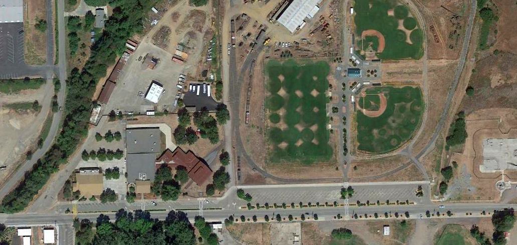
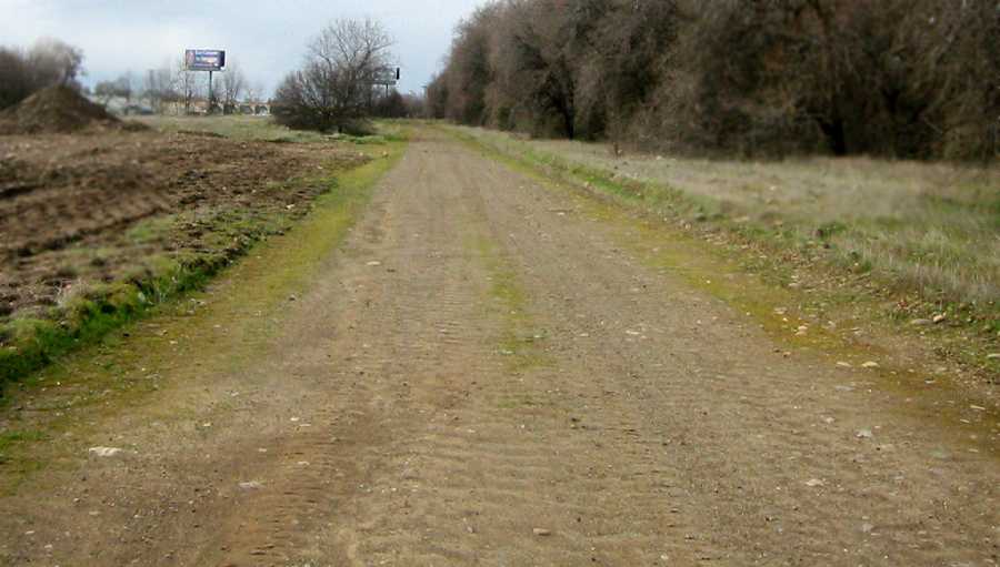
A 1998 aerial photo showed the Peterson Chico runway pavement had been removed,
although the alignment of the runway was still recognizable.
According to Jonathan Westerling, “Eventually the runway was destroyed
because kids were drag racing on it so Peterson had the asphalt ripped up.”
The 1999 USGS topo map still depicted the “Peterson Chico Airfield”,
with a single paved northwest/southeast runway.
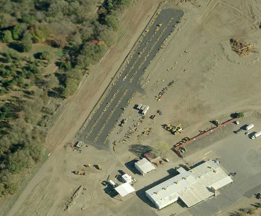
A circa 2006 aerial view looking east at the remains of the Peterson Chico Airfield,
showing a portion of the asphalt runway which remained, along with the tractor company building.
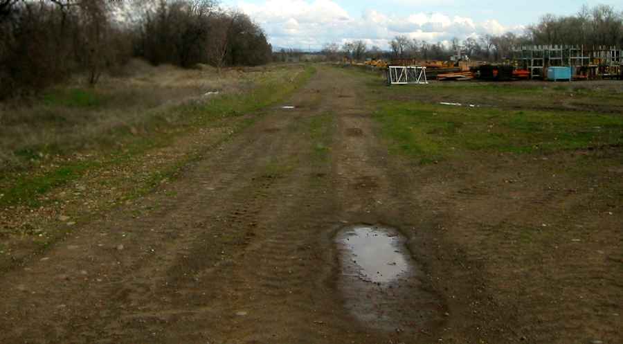
A 2007 photo by Jonathan Westerling “looking east along the orientation of the removed runway at Peterson-Chico.”
A 2007 photo by Jonathan Westerling “looking west behind the Peterson Tractor Company’s Chico location where the airport used to be.”
Jonathan Westerling reported in 2009, “Today, the Peterson Tractor Company continues as a thriving business.
The area that the runway once occupied is now a dirt road behind their Chico store.
I think Mr Peterson’s pair of airfields ranks as unique in California.
Were there any other non-aviation companies who built & maintained more than one airfield?
Both were fairly extensive & apparently important to his company & clients.
I enjoyed talking with some of the employees about these airfields’ histories.”
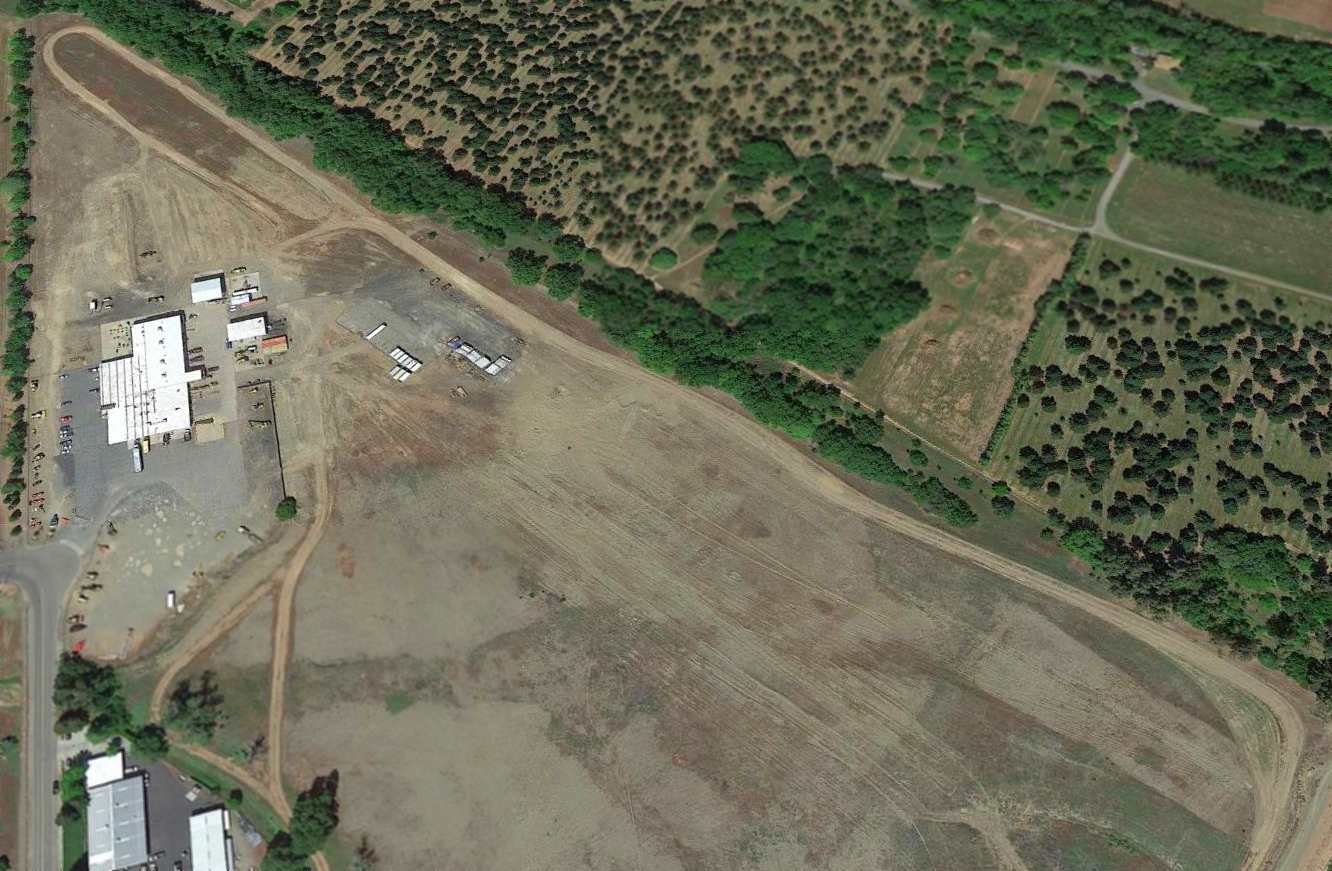
A 2015 aerial view looking northwest shows the alignment of the former Peterson Chico runway remained recognizable.
The site of the Peterson Chico Airfield is located northeast of the intersection of Route 99 & Southgate Avenue.
____________________________________________________
Peterson Redding Airfield, Redding, CA
40.63, -122.38 (Northeast of San Francisco, CA)
A 1963 aerial photo of the newly constructed Peterson Tractor airfield (courtesy of Jim Lanphear).
According to Jonathan Westerling, “The Peterson-Redding Airport was the second of 2 airports & a heliport
owned by the Howard Peterson Tractor Company.
The airport was primarily used to ferry tractor parts between the company’s northern California stores.
According to Eileen Grafton, Howard Peterson’s granddaughter,
customers were also allowed to use the airstrips to pick up parts from the warehouse next to this airport,
and from the Chico location which also had an airfield.”
Jonathan continued, “The Peterson-Redding airfield was built in 1963
over the top of a grass strip that the previous property owner had put in.
According to Al Mayr who was the company pilot,
the Peterson runway orientation was superior to the earlier grass strip because it fit better into the property lines,
and was better for the prevailing winds.”
The earliest depiction which has been located of the Peterson Redding Airfield
was a 1963 aerial photo (courtesy of Jim Lanphear).
It depicted the field as having a single asphalt north/south runway,
with an asphalt taxiway leading to a ramp on the southeast corner, next to the Peterson building.
It also depicted the predecessor grass northeast/southwest runway.
According to Jerry Evans (who managed the Redding store for many years),
“I remember we had 2 wheels-up landings at the strip.
One was by a customer. He was coming in to pick up parts & forgot to go wheels-down.
There was one heck of a noise & we went out to see what was happening
and a very sheepish [pilot] was walking toward the shop.
I believe they repaired the plane at the shop (they brought in aircraft mechanics) & he flew it out.”
Jerry continued, “We also used [the airstrip] to deliver parts – in emergencies to our customers.
There was a time when Lee Stower was working on the back side of Mt. Lassen.
Someone forgot to put one of the bearings for a final drive in the part given to him.
It would have taken about 5 hours for him to drive for the part & return to the job.
If I remember it was less than a half hour for us to fly to the site.
We wrapped the bearing – which was maybe 8” in diameter & about 2” thick – in newspaper.
Many, many wraps, then put heavy duty tape around that.
Then we put it in a box & stuffed that full of paper & put tape over every inch of the box.
I went up with Al Mayr – our pilot – and when we got to the site, Al got as low & slow as he safely could,
then I opened the door, held it open with my knee & at the right moment dropped the box.
It hit the ground, bounced a number of times & rolled to about 10 feet of where Lee was standing.”
According to Jonathan Westerling, “Al Mayr (the pilot at Redding) fondly recalls the strip as being fairly narrow,
but on a hill up the valley which kept the fog away more so than the nearby municipal airfields.
He said it was always a private facility, but they didn’t paint X’s on the runway because that would have been 'unfriendly'.
The Redding facility had a 1,000 gallon tank of 80 octane fuel on site & a single ‘T’ hangar.”
The Peterson Redding Airfield was not yet depicted on the May 1965 Mt. Shasta Sectional Chart.
A 1965 aerial view looking southwest at the Peterson Redding facility (courtesy of Eileen Grafton),
with aircraft parking spots behind the store,
and a taxiway leading to the runway, the southern end of which is visible in the background.
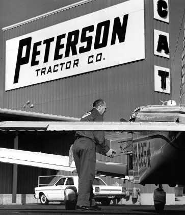
An undated promotional photo showing parts being loaded into a Peterson Piper (courtesy of Eileen Grafton).
The earliest aeronautical chart depiction which has been located of the Peterson Redding Airfield
was on the May 1966 Mt. Shasta Sectional Chart (courtesy of Chris Kennedy).
It depicted Peterson as having a single 2,500' paved northeast/southwest runway.
The 1967 AOPA Airport Directory (courtesy of Jonathan Westerling)
described Peterson-Redding as having a 2,500' asphalt Runway 18/36.
The 1968 FAA Airport Facilities Record (courtesy of Al Mahr)
described Peterson-Redding as having a 2,376' north/south runway.
It listed the owner as Peterson Tractor Company, and the operator as Grant Thompson.
The last aeronautical chart depiction which has been located of the Peterson Redding Airfield was on the May 1969 Mt. Shasta Sectional Chart.
It depicted Peterson as a private airfield having a 2,700' paved northeast/southwest runway.
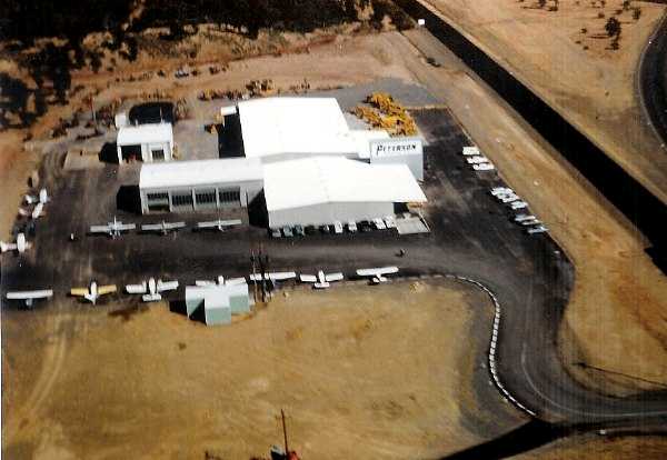
An undated aerial view looking northeast at no less than 13 aircraft at the Peterson-Redding airfield (courtesy of Al Mayr).
According to Duane Doyle (Peterson’s grandson & now owner of the company), they quit using the airstrips between 1977-80.
It became cost prohibitive to ship parts by air compared to courier.
The 1979 AOPA Airport Directory (courtesy of Jonathan Westerling)
described Peterson-Redding as a private field having a 2,500' asphalt Runway 18/36, only 36' wide.
The 1991 USGS topo map still depicted the Peterson “Landing Strip” as a single north/south runway,
as well as the grass northeast/southwest runway that predated it.
According to Duane Doyle (Peterson’s grandson & now owner of the company),
eventually the runway was destroyed because kids were drag racing on it so Peterson had the asphalt ripped up.
A 1993 aerial view showed that the northern half of the Peterson Redding Airfield runway had become Charles Drive.
A circa 2006 aerial view looking north at the site of the Peterson Redding Airfield.
The company's store remains, but the runway has been completely built over.
A 2009 photo by Jonathan Westerling “looking south along what used to be the runway at Peterson-Redding airport.”
Jonathan Westerling reported in 2009, “Today, the Peterson Tractor Company continues as a thriving business, though without their airfields.
The north part of the runway has been reused as Charles drive.”
A 2015 aerial view looking northwest at the site of the Peterson Redding Airfield showing that the paved runway has become Charles Drive,
but the outline of the northeast end of the predecessor northeast/southwest runway is still perceptible.
The site of the Peterson Redding Airfield is located northwest of the intersection of Route 273 & Caterpillar Road.
____________________________________________________
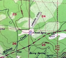
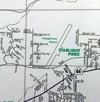
Shingletown Airport (0Q6), Shingletown, CA
40.52, -121.82 (Northeast of San Francisco, CA)
Shingletown Airport, as depicted on a 9/3/54 USGS aerial photo.
The date of construction of Shingletown Airport has not been determined.
The earliest depiction of Shingletown Airport which has been located was on a 9/3/54 USGS aerial photo.
It depicted a single unpaved northeast/southwest runway.
The 1956 USGS topo map (courtesy of Kevin Walsh) depicted Shingletown Airport
as a single northeast/southwest runway, labeled simply as “Landing Strip”.
The Shingletown Airport was not yet depicted at all on the April 1959 Mt. Shasta Sectional Chart.
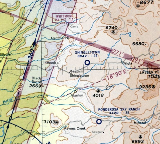
The earliest aeronautical chart depiction which has been located of Shingletown Airport was on the September 1959 Mt. Shasta Sectional Chart.
It depicted Shingletown as a public-use airport having a 2,400' unpaved runway.
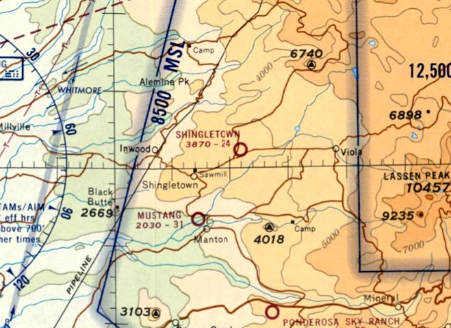
The earliest aeronautical chart depiction which has been located of Shingletown Airport was on the May 1969 Mt. Shasta Sectional Chart.
It depicted Shingletown as a public-use airport having a 2,400' unpaved runway.
The 1980 Flight Guide (according to Chris Kennedy) listed Shingletown as having a 2,000' unpaved runway.

The Low-use section of the 1994 Flight Guide (courtesy of Chris Kennedy)
depicted Shingletown as having a single 2,340' “Oiled Ruf” Runway 1/19, sloping 2.6% up toward the north.
A ramp was depicted as having a single small hangar on the southwest side.
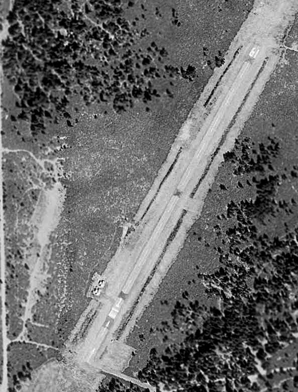
In the 1998 USGS aerial view of the Shingletown Airport,
it appeared as if closed-runway “X” symbols had been painted on the runway at some point,
and then painted over (with gray paint) at some later point, as if the runway was re-opened.
A 1999 street map (courtesy of Kevin Walsh) still depicted Shingletown Airport as a single northeast/southwest runway, with a ramp on the east side.
The Shasta County website (courtesy of Jonathan Westerling) noted in 2007 that “The airport was closed indefinitely, effective 11/1/02.
Please be advised that the Shasta County Department of Public Works
has been notified by the California Department of Transportation, Division of Aeronautics
that, due to the unsafe condition of the airport, and in meeting DOT's public safety mandate,
the airport permit for the Shingletown Airport is suspended, effective 11/1/02."
Jonathan Westerling reported in 2007, “I interviewed Thomas Hayes who is the airport manager for Shasta County.
He confirmed that the county has voluntarily surrendered its suspended airport permit to the State.”
Hayes said they have “Walked away from the airport. We stuck a fork in it, and it's done.”
According to Jonathan Westerling, “Hayes said he had tried several times to secure government grants to fix the runway.
Apparently the County was in a catch-22 regarding Shingletown since it did not own the land that the airport was on.
Since it didn't own the land, Shasta was unable to get any FAA funds to fix the airport.
Also, since the runway was in such bad shape
the County was unable to secure any airport grants to purchase the land from the owner.”
Lamenting the loss of the airport, Mr. Hayes admitted that "With only 600 flights a year, it just wasn't a good candidate for grant money."
Jonathan Westerling reported that Hayes “did however indicate that several parties
had approached the landowner (Bady & Associates Redding, CA) with an interest in taking over the airfield.
While none of these conversations have yet amounted to anything,
now that the County has decided to loose its year-to-year lease on the property,
perhaps the opportunity exists for an enterprising individual to resurrect this nice little airfield in the northern hills of CA.”
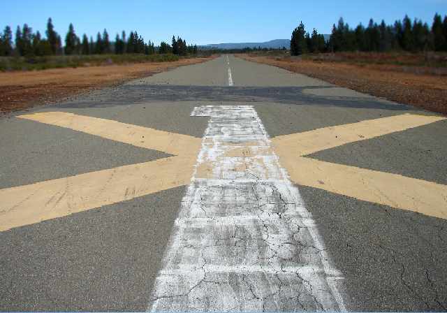
A 2007 photo by Chris Knudson looking north along the former Runway 1 at Shingletown.
Note both the yellow “X” closed-runway symbol over the runway number,
but also evidence right above it of a previous closed-runway “X” which had been painted over with gray paint.
Chris Knudson visited the site of the Shingletown Airport in 2007.
He reported, “I saw a road sign called 'Airport Road' & had to check it out.
The Shingletown Airport has a simple gate barring access to vehicles but you can easily walk around the gate.
All that is left at the field is 2 abandoned wooden hangars in bad shape
and the 2,340' runway that looked in good shape, but after walking on it seemed cracked & crumbly.
There is evidence that the locals may use the runway as a makeshift drag strip.
Start & line-up markers have been spray painted on the runway with some sort of tire burnouts.”
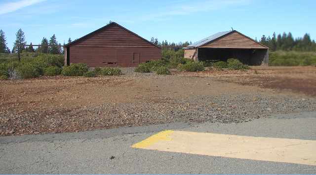
A 2007 photo by Chris Knudson looking west at the two former hangars at Shingletown.
A 2007 photo by Chris Knudson of the interior of a former hangar at Shingletown.
Michelle Stone reported in 2007, “The biggest single use for the Shingletown Airport now is for amateur astronomers.
For several years, they have been gathering there to do astronomy.”
A 2009 aerial view showed that the Shingletown hangars had been removed at some point between 2007-2009,
but the runway pavement remained intact.
A 2010 aerial view showed that the runway pavement had been removed.
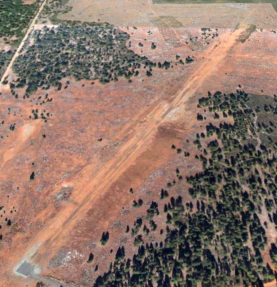
A 9/23/12 aerial view looking north at the remains of the Shingletown runway.
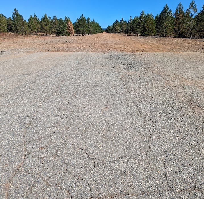
A September 2023 photo by Scott Van Artsdalen looking north at the last remaining paved portion of the Shingletown runway.
Scott reported, “Many trees have been planted to ensure the runway is unusable.”
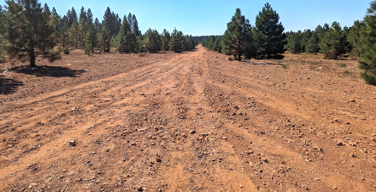
A September 2023 photo by Scott Van Artsdalen looking south along the remains of the Shingletown runway.
The site of the Shingletown Airport is located north of the intersection of Emmigrant Trail & Airport Road, appropriately enough.
____________________________________________________
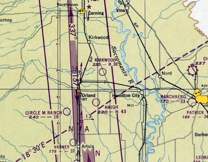
Kirkwood Auxiliary Army Airfield #2 / Orland Auxiliary Airport #2 / Kirkwood Airport,
Kirkwood, CA
39.79, -122.13 (Northwest of Sacramento, CA)
Kirkwood Airport, as depicted on a 7/10/47 USGS aerial photo.
Photo of the airfield while in use has not been located.
According to the Army Corps of Engineers, the history of this airfield began on 10/8/42 when the War Department acquired 360 acres of farmland
through direct purchase to build an auxiliary airfield.
This airfield was one of 5 auxiliary fields subordinate to the Chico Army Air Field.
The Site provided a location for emergency landings by aviation cadets & any other transient aircraft operating in the area.
The Site also provided an off-site training location for the Army Air Forces Basic Flying School at Chico AAF.
USACE records indicated that the field had the capacity of supporting 40 aircraft per day.
As this field supported a basic flying school, the primary aircraft operating at this field would have be the Vultee BT-13 “Valiant”.
WAA records indicate that the infrastructure at the Site consisted of a 3,000-foot square asphalt landing mat
with a few Theater of Operations-type buildings to provide a minimal level of support.
No evidence of fueling systems, tanks, ammunition storage, or maintenance facilities was located during research.
There was no troop housing or messing facilities located at this installation.
The layout of the Kirkwood airfield, consisting of a square paved landing mat,
is identical to other nearby airfields built to serve as auxiliary airfields for Chico AAF,
including Chico Aux AAF #3, and Orland Airport.
However, the Kirkwood airfield was not depicted on the 1943/44/45 Sacramento Sectional Charts.
In 1944, basic pilot training at Chico Army Air Field ended which resulted in reduced use of the Kirkwood airfield.
Chico AAF itself (the parent field) was inactive by the time of the 1945 AAF Airfield Directory (courtesy of Scott Murdock),
and the Kirkwood auxiliary field was no longer listed in the directory.
On 11/20/46, control of the Kirkwood auxiliary field was transferred to the WAA.
The WAA in turn quitclaimed the Site to County of Glenn on 6/19/47.
The earliest depiction of the field which has been located was a 7/10/47 USGS aerial photo.
It depicted a square paved landing mat, with one small building on the east side.
The Kirkwood airfield still was not depicted on the February 1949 Sacramento Sectional Chart.
The Kirkwood airfield was subsequently reused as a civilian airport.
The earliest aeronautical chart depiction which has been located of Kirkwood Airport was on the September 1949 Sacramento Sectional Chart.
It described Kirkwood Airport as having a 3,000' paved runway.
The 1950 USGS topo map depicted “Orland Auxiliary Airport #2” as a square outline.
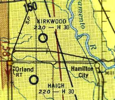
The 1954 Sacramento Sectional Chart (courtesy of Dann Shively) described Kirkwood Airport as having a 3,000' hard-surface runway.
The 1967 Sacramento Sectional Chart (courtesy of John Voss)
depicted Kirkwood's unusual square runway layout, which was described as being 4,200' long.
The 1968 USGS topo map continued to label the site as “Orland Auxiliary Airport #2”.
The County of Glenn operated Kirkwood as an airfield until approximately 1970.
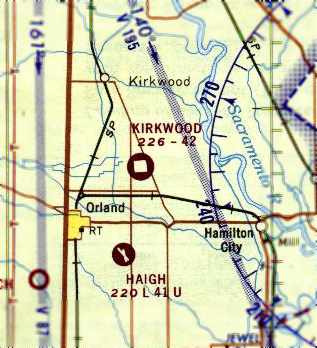
The Kirkwood Airport was evidently closed (for reasons unknown) at some point between 1967-70,
as it was depicted as an abandoned airfield on the 1970 San Francisco Sectional Chart (courtesy of Dann Shively).
The 1971 USGS topo map labeled the site as “Kirkwood Airport”.
Dann Shively recalled, “I flew out of nearby Haigh Field in Orland in 1971-72.
Haigh originally was one of the several big squares of pavement used in WW2 training which was extensive in the Northern Sacramento Valley.
Apparently Kirkwood Airport was yet another practice mat.
When I was flying around there, I noticed this pad but never thought too much about it other than it was interesting.
Nothing appeared to be going on there & I never gave it much attention.
I didn't know at the time it was an airport only a few years earlier.”
The 1985 Sacramento Sectional Chart (courtesy of Dann Shively) depicted Kirkwood as an abandoned airfield.
According to the Army Corps of Engineers, “The original asphalt landing strip was demolished after disposal of the site
and the paving debris placed in 3 piles on the property.”
By the time of the 1990 Sacramento Sectional Chart (according to Dann Shively)
the former Kirkwood airfield was no longer depicted at all (not even as an abandoned airfield).

Although it had evidently been closed for several years,
the 1991 USGS topo map still depicted “Kirkwood Airport” as having a square landing mat.
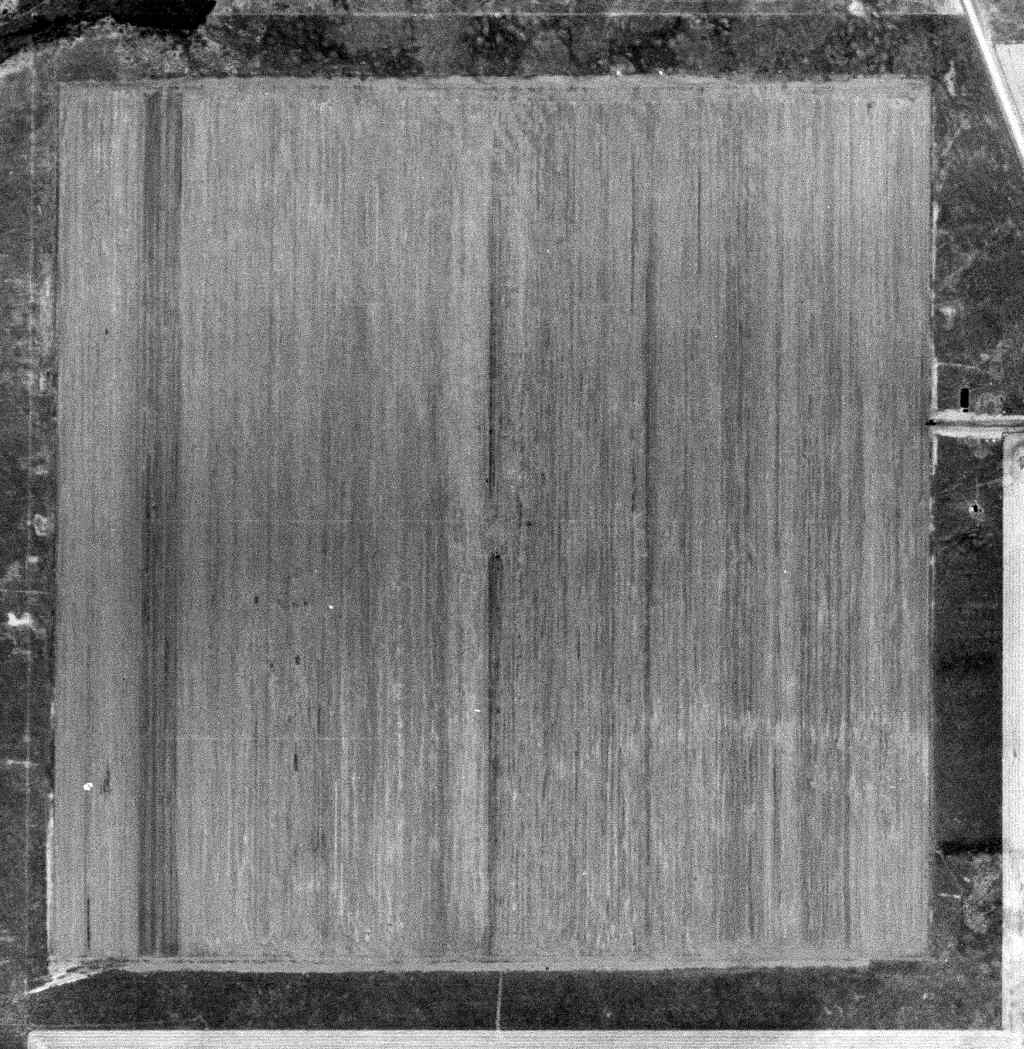
The 1998 USGS aerial photo shows that the pavement of Kirkwood's former landing mat has been completely removed,
with the property reused for farming.
The 3 piles of rubble from the former airfield pavement are evidently still visible
as the 3 shapes along the south side of the road in the center of the picture.
A 2008 aerial view by Dann Shively looking northeast at 2 of the 3 piles of former airfield pavement at the site of the Kirkwood airfield.
Dann observed, “The piles are still there amid the orchards in the area; although at least one seems to be dwindling.
I shot the other two, one of which has a lot of trash around it.
Not often an airport goes away but the pavement is just piled on the site.”
The site of the Kirkwood Airport is located west of the intersection of 6th Avenue & Cutler Avenue.
Thanks to Dann Shively for pointing out this airfield.
____________________________________________________
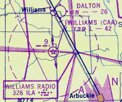
Williams Intermediate Field, Williams, CA
39.09, -122.15 (Northwest of Sacramento, CA)

Williams Intermediate Field Site 9, as depicted on the May 1936 Sacramento Sectional Chart.
The Williams Intermediate Field was one of the Department of Commerce's network of airfields which were established in 1930s
for the emergency use of commercial aircraft along major airways in between major cities.
The date of construction of the Williams field has not been determined.
The earliest reference to the field which has been located
was in The Airport Directory Company's 1933 Airport Directory (courtesy of Chris Kennedy).
It described Williams as the Department of Commerce's "Site 9" along the San Francisco - Seattle Airway.
The field was said to consist of a rectangular sod field, measuring 2,640' x 1,320'.
The earliest depiction of the Williams Intermediate Field which has been located was on the May 1936 Sacramento Sectional Chart.
It depicted Williams as Site 9.
The only photo which has been located of Williams Intermediate Field
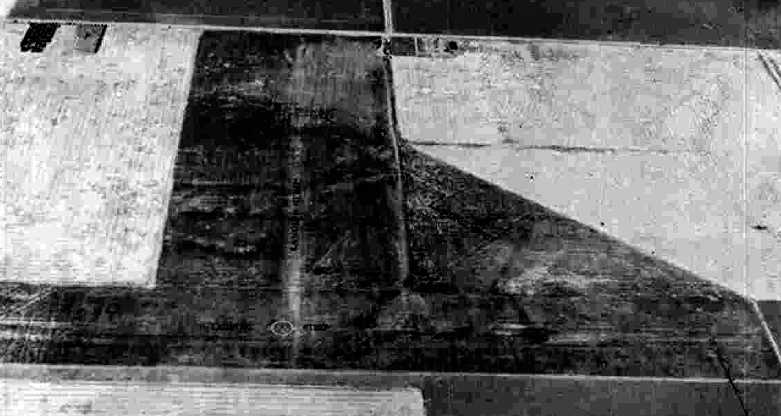
was a 9/10/43 aerial view looking north from the 1945 AAF Airfield Directory (courtesy of Scott Murdock).
Williams had evidently been expanded at some point between 1933-45, as it depicted the field as having 3 unpaved runways.
No buildings were depicted at the airfield.
The 1945 AAF Airfield Directory (courtesy of Scott Murdock) described the Williams Intermediate Field
as a 206 acre irregularly-shaped property having 3 sod runways, the longest being a 3,950' northwest/southeast strip.
Williams was not said to have any runways, to be owned by private interests, and operated by the Civil Aeronautics Administration.
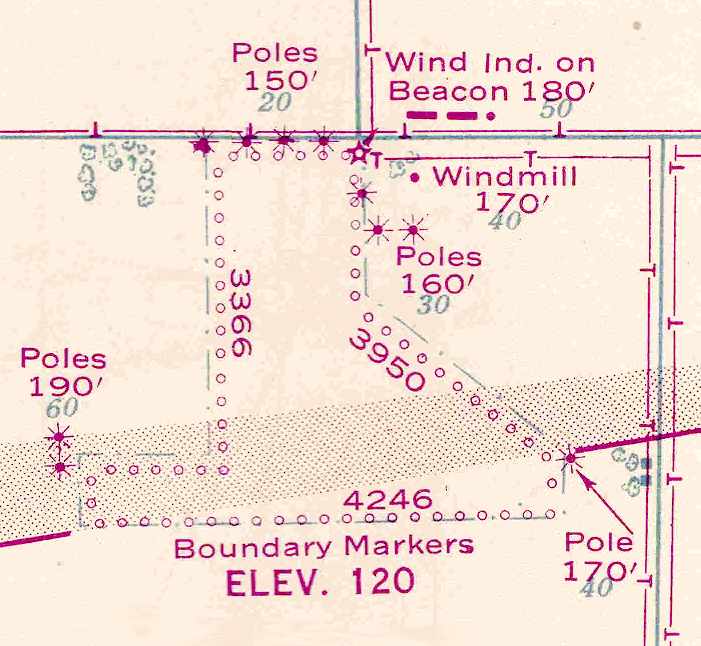
The November 1945 USAAF Pilot's Handbook(courtesy of Chris Kennedy)
depicted the Williams Intermediate Field as a sod field measuring 4,246' east/west by 3,366' north/south.
No buildings were depicted at the airfield.
The February 1949 Sacramento Sectional Chart (courtesy of Chris Kennedy) depicted the "Williams (CAA)" airfield as having a 4,200' unpaved runway.
The Williams airfield was evidently closed at some point between 1949-52,
as it was no longer depicted at all on the November 1952 Seattle to San Francisco Flight Chart (according to Chris Kennedy).
Like many other Intermediate Fields, it was evidently no longer needed, due to advances in aircraft reliability.
Although the 1973 USGS topo map no longer depicted any traces of the former airfield,
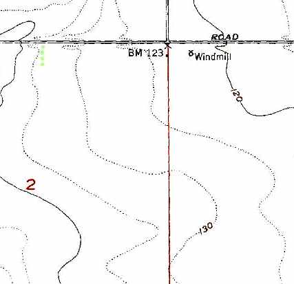
the windmill at the northeast corner of the airfield was still depicted (the same windmill depicted on the 1945 airfield diagram).
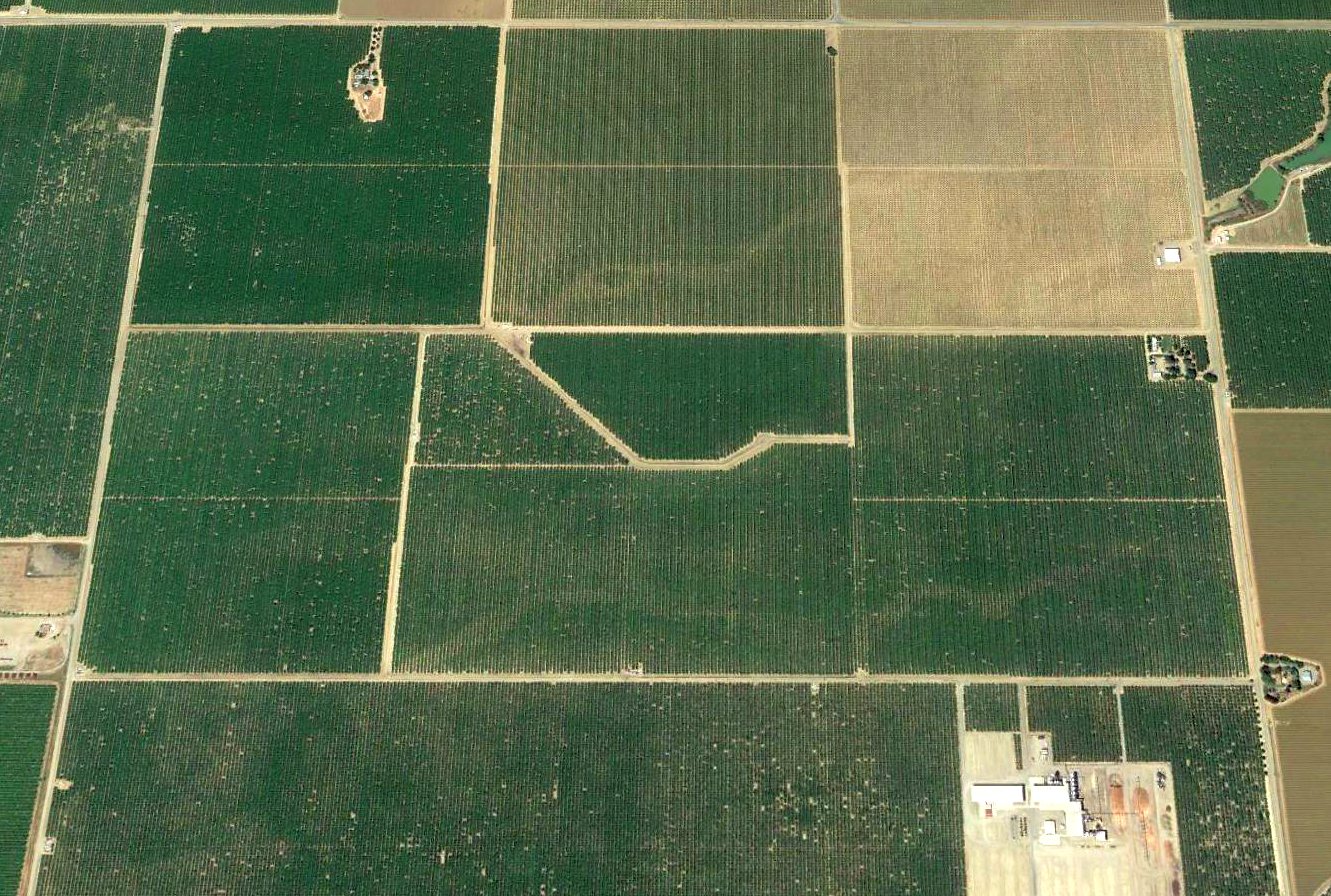
A 1998 USGS aerial photo showed the site of Williams Intermediate Field had been reused for farming,
and not a trace appeared to remain of the former airfield.
A 2017 aerial view looking north showed no trace remains recognizable of Williams Intermediate Field.
The site of Williams Intermediate Field is located south of the intersection of Zumwalt Road & Myers Road.
Thanks to Chris Kennedy for pointing out this airfield.
____________________________________________________
Union Lumber Company Airfield, Fort Bragg, CA
39.434, -123.815 (Northwest of San Francisco, CA)
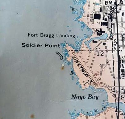
The Union Lumber Company Airfield, as depicted (the propeller symbol just south of the “Soldier” label) on a 1948 CA Forestry Division map (courtesy of Kevin Walsh).
This private airfield was located in an extremely picturesque setting,
being on the tip of a peninsula which juts out into the Pacific Ocean.
No airfield was yet depicted at this location on a 1941 aerial photo (courtesy of Jonathan Westerling).
The earliest depiction which has been located of the Union Lumber Company Airfield
was on a 1948 CA Forestry Division map (courtesy of Kevin Walsh).
According to Kevin Bunker, “This strip was graded, paved & opened in 1948-49
when the Union Lumber Company took delivery of its sole corporate aircraft, a Twin Beech monoplane.”
The earliest photo which has been located of the Union Lumber Company Airfield
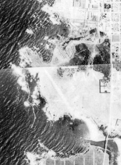
was a 1952 aerial photo (courtesy of Jonathan Westerling),
which a single unpaved northwest/southeast runway on the peninsula jutting into the Pacific Ocean.
The earliest aeronautical chart depiction which has been located the Union Lumber Company Airfield
was on the March 1954 USAF Sacramento Sectional Chart (courtesy of Chris Kennedy).
It depicted the airfield as having a 2,400' hard-surface runway,
for "Emergency use only" (which evidently was how a private airfield was labeled).
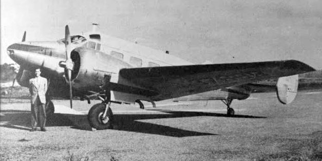
An undated photo of the Union Lumber Company's Beech 18, named “Noyo Chief”, from a circa 1955-60 company brochure (courtesy of Kevin Walsh).
It described their plane: “The 2nd 'Noyo Chief', manned by experienced pilot & copilot.”
The 1962 AOPA Airport Directory described the Union Lumber Company Airfield
as having a single 2,700' asphalt Runway 13/31.
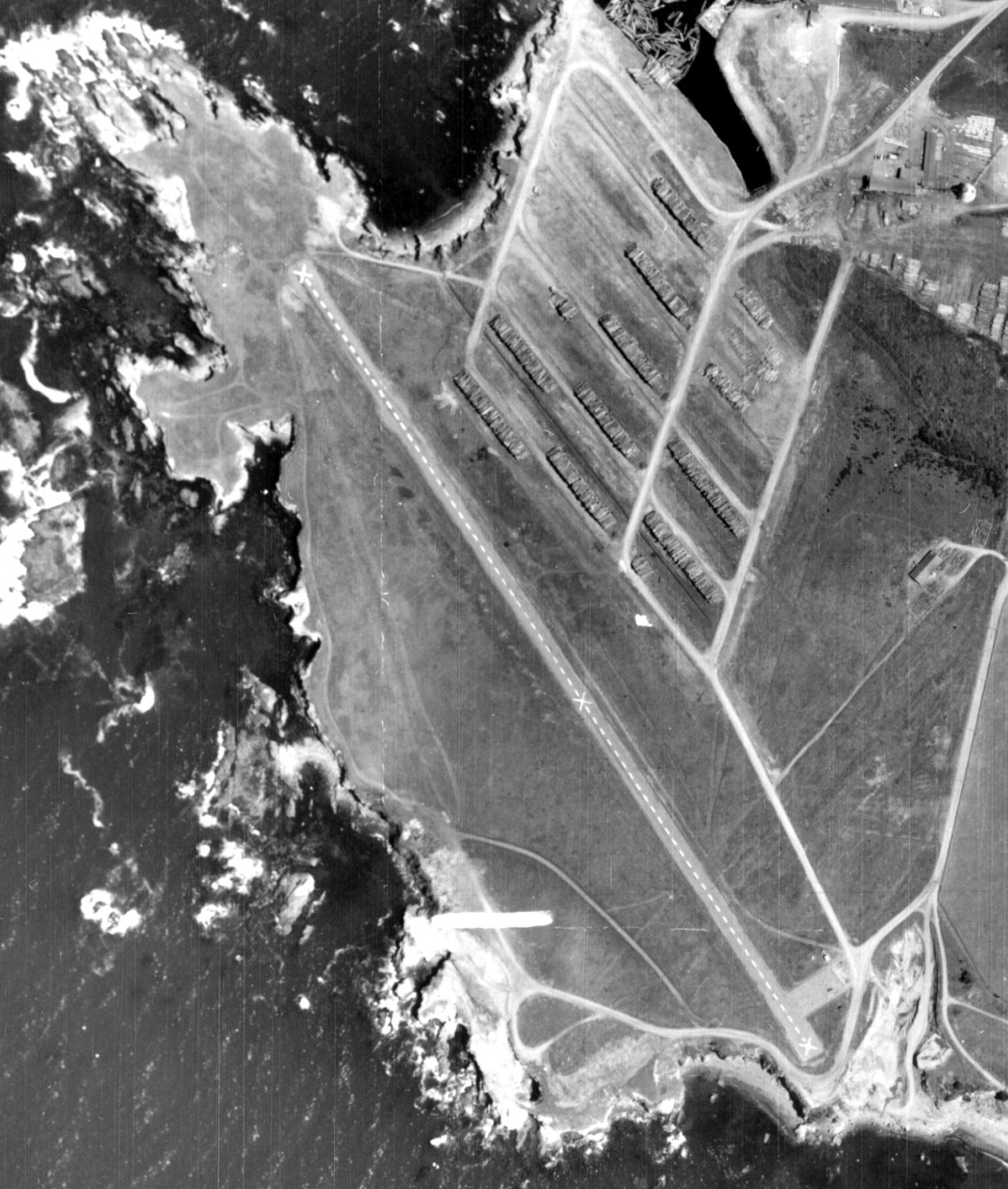
A 1963 aerial photo (from the UCSB Library, courtesy of Jonathan Westerling) depicted the Union Lumber Company Airfield as having a single northwest/southeast paved runway
and a small paved ramp on the southeast side.
The Union Lumber Company Airfield was depicted on the 1964 USGS topo map (courtesy of Kevin Walsh)
as a single paved northwest/southeast runway, labeled simply as “Airstrip”.
Chuck Ross recalled of the Union Lumber Company Airfield, "At one time a USAF F-102 crashed at that airport.
There is a picture of the wreck on page 112 of "The Mendocino Coast - a Pictorial History Volume II", published by the Fort Bragg Advocate.
The plane looked as though it was not badly damaged by the (apparently) wheels-up landing but was partly consumed by post-crash fire."
The Union Lumber Company Airfield was still depicted as an active private airfield
on the 1967 Sacramento Sectional Chart (courtesy of John Voss).
According to Kevin Bunker, “Union Lumber Company operated the strip to shuttle its corporate officers & official guests
from its San Francisco headquarters to its mill offices & woods properties in Fort Bragg & the surrounding county until 1969.
Union Lumber Company ceased independent business in 1969 when it was acquired by the Boise-Cascade Corporation.
Boise-Cascade Corporation was forced to divest of the Fort Bragg mill properties in a Sherman Act (anti-trust) breakup.
To my knowledge, the runway remained in service as late as 1970 but not likely any later.
Georgia-Pacific & subsidiary Louisiana Pacific Corporations acquired
the former Boise-Cascade Corporation / Union Lumber Division properties in 1972.”
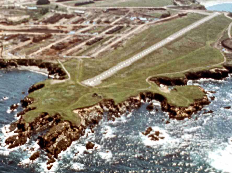
A 1972 aerial view looking southeast at the Union Lumber Company Airfield (© 2002-2009 Kenneth & Gabrielle Adelman, CA Coastal Records Project, used with permission)
showed a closed-runway “X” symbol painted on the runway end.
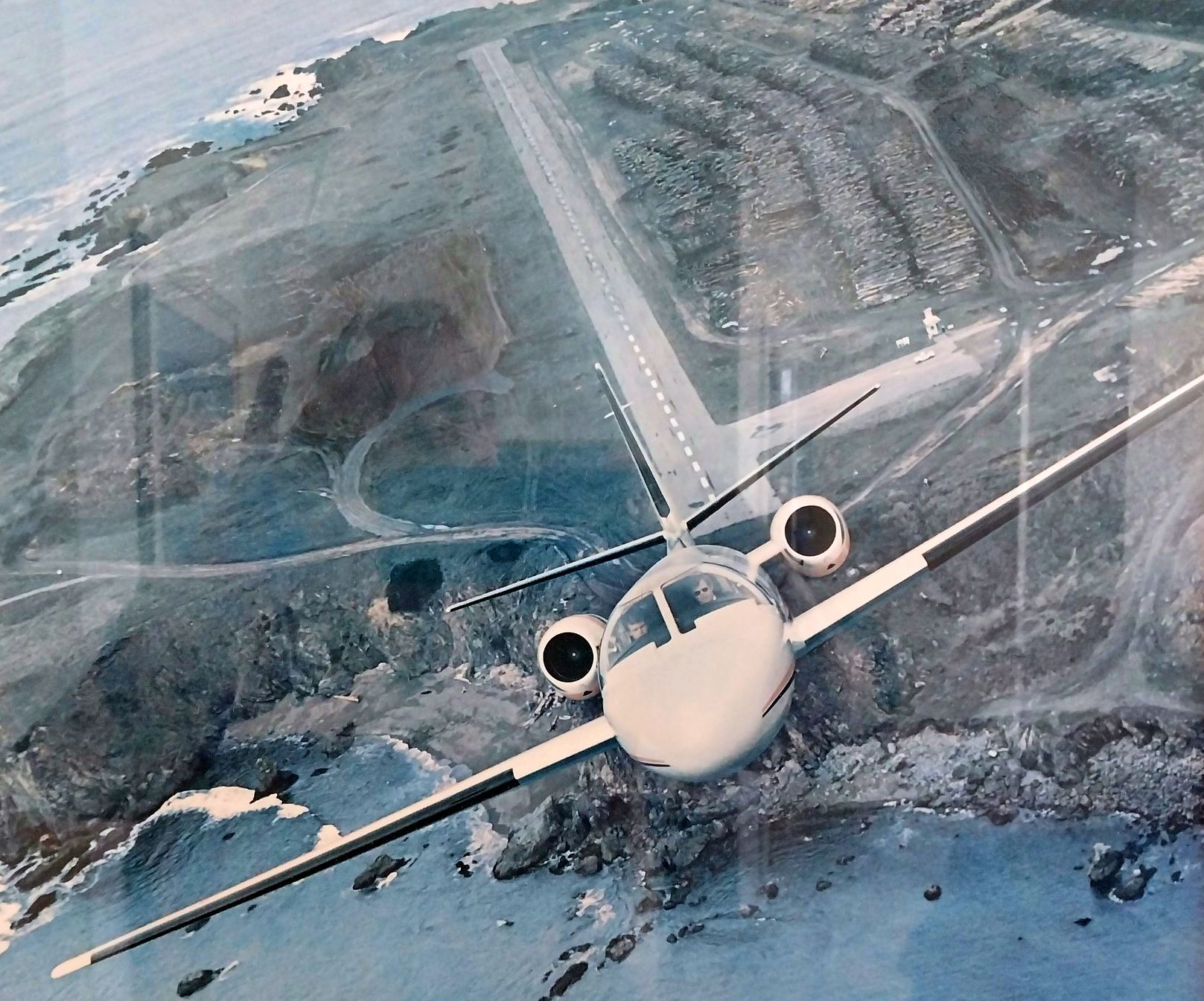
A 1977 aerial view looking north at a Cessna Citation SII with the Union Lumber Company Airfield underneath.
The extremely picturesque setting of the Union Lumber Company Airfield caused it to have its "moment in the spotlight":
as it was the backdrop for a widely used marketing photo taken air-to-air by aviation photographer Paul Bowen.
He captured a Cessna Citation SII from head-on in a steep climb,
with the seaside runway of the Union Lumber Company Airfield being dramatically set in the background.
The photograph was taken from the tail turret of a vintage B-25 Mitchell WW2-era bomber.
A 1979 aerial view depicted the Ft. Bragg Airfield in basically the same condition as depicted in 1972.
According to Kevin Bunker, “[The runway's] surface was reclaimed for lumber storage sometime around 1980.
Back in 1984 my buddy who was 19 & I 20 years old, flew up to Fort Bragg from the Nut Tree airport in Vacaville with our girlfriends in his parents' Musketeer”
The Union Lumber Company Airfield was still depicted as an active private airfield
on the 1987 CA Aeronautical Chart (courtesy of John Voss).
According to Jeffrey Osier-Mixon, "They did indeed have lumber stacked on it, beginning in the early 1990s,
about when the Union Lumber Company sold the property to Georgia-Pacific, who use helicopters & bizjets for travel -
bizjets prefer to land at Little River Airport, and the helicopters can land without a runway."
The Union Lumber Company Airfield it was no longer depicted at all on the 1998 aeronautical chart.
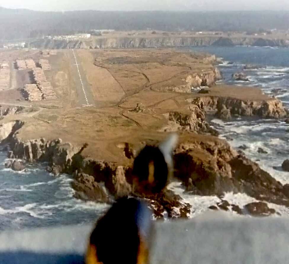
A 1984 aerial view by Gonzalo Curiel looking northwest at the Union Lumber Company Airfield.
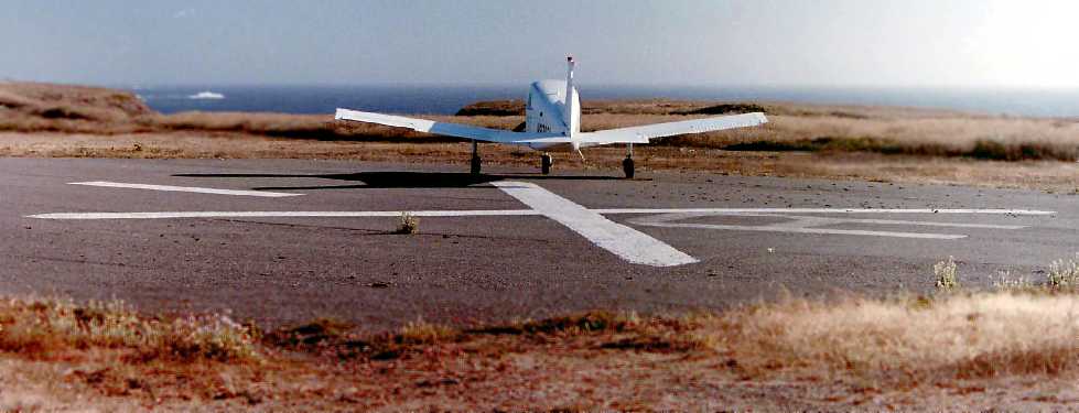
A 1984 photo by Gonzalo Curiel of his friend Ross' Musketeer at the Union Lumber Company Airfield.
Gonzalo recalled, “My buddy & I flew up to Fort Bragg from the Nut Tree airport in Vacaville with our girlfriends in his parents' Musketeer”
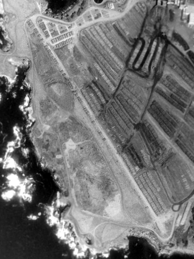
In the 1998 USGS aerial photo, the runway was being used to store lumber.
Jeffrey Osier-Mixon reported in 2004, "As of 2002, the mill has been closed & the bluff -
all 300-some-odd acres of it - is up for sale.
There has been no end of controversy around it, as the lumber company left quite a toxic mess to clean up,
and the property will need a lot of redevelopment work by whomever chooses to purchase it.
I don't think the town would tolerate a runway there at this point,
though as a local resident pilot I think it would be nice!
In any case, sometime in the next 10 years we all expect to see housing developments, maybe a few shopping centers,
and hopefully a few bluffside parks to take advantage of the only coastside property in Fort Bragg."
A beautiful 4/1/12 aerial view by Gonzalo Curiel looking east at the Union Lumber Company Airfield & the dramatic coastline adjacent to it.
As of 2015, news reports indicated the Union Lumber Company runway is being considered for reuse as an access road for the redevelopment of the mill site.
Bill Grasha observed, “I was impressed with Union Lumber Field. It looked like an airstrip built by a golf course designer.”
A beautiful 2/6/16 aerial view by Gonzalo Curiel looking east at the Union Lumber Company Airfield.
Gonzalo reported, “They opened the old Union Lumber airstrip up with parking on one end & hiking trails along the coastline.”
An April 2016 photo by Gonzalo Curiel (enhanced by Bill Grasha) of the park sign commemorating the Union Lumber Company Airfield runway, showing the company's Beech 18.
An April 2016 photo by Gonzalo Curiel of the Union Lumber Company Airfield runway.
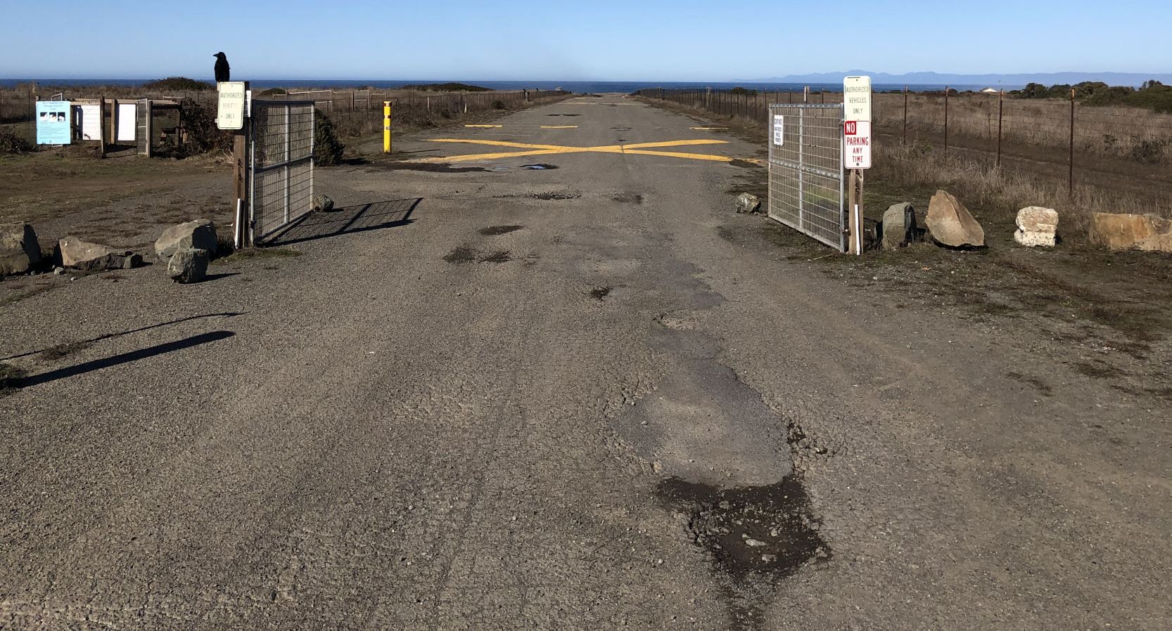
A 10/26/20 photo by Jonathan Westerling looking along the remains of the Union Lumber Company Airfield runway, with the yellow closed-runway “X” markings prominent.
As of 2023, street maps show the former Union Lumber Company Airfield runway has been reused as Jere Melo Street, within the Noyo Headlands Park which now encompasses the airport site.
The Union Lumber Company Airfield site is located at the western end of North Noyo Point Road.
____________________________________________________
Willow Creek Airport, Willow Creek, CA
40.95, -123.636 (Northwest of San Francisco, CA)
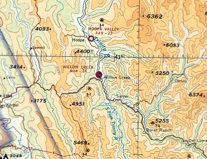
Willow Creek Airport, as depicted on the November 1967 Mt Shasta Sectional Chart.
This small airport was apparently built at some point in 1967, as it was not yet depicted on the May 1967 Mt Shasta Sectional Chart.
The earliest depiction which has been located of Willow Creek Airport was on the November 1967 Mt Shasta Sectional Chart.
It depicted Willow Creek as having a 2,400' northwest/southeast paved runway.
Willow Creek Airport, as depicted on the 1976 USGS topo map.
Willow Creek Airport closed in 1982.
Stuart Till reported, "The Humboldt County Airports Department placed Xs on the runway…
because they did not want to accept the liability… they did not want the general public landing there."
According to Rick Ohman, The “County of Humboldt closed Willow Creek because it did not have clear zones & the gravel operations vehicles posed a clear & present danger.”
According to Gene Roberts, “I think that the reason it was closed is that trees on both ends grew too tall & there may have been either an accident or concerns.
A good pilot with a STOL plane could probably land there OK in an emergency.”
Stuart Till reported that he continued to operate from Willow Creek Airport "as a law enforcement agency even though it was X'd [marked as closed].
I flew in & out of Willow Creek airport from about 1982-86.
We used this airport for mountain flying instruction when I was Chief Pilot for the California Department of Justice.
We used Cessna T-210 & T-182RG aircraft, which were also used for law enforcement surveillance.
This is a very demanding airport with obstacles on both ends, wind shear, and it is short to boot.
This is typical of runways built along rivers in narrow valleys, i.e. they require check-outs & demonstrated competency."
An 8/18/88 aerial view looking northeast at Willow Creek Airport showed it consisted of a single 2,500' asphalt Runway 13/31,
and a small paved ramp area west of the southern runway end, painted with “Willow Creek” lettering, and on which were 2 single-engine aircraft.
Tim Swenson reported in 2004, "I was just in the Willow Creek area vacationing when I came across the airport.
I was driving through town looking for a way down to the Klamath river.
There a sign pointing to place for river access & what looks to be a very rough boat launch area.
It turns out that the river access is at the southern end of the runway about 20 yards from the threshold.
I even walked out to the threshold.
I did not see any buildings at the airport, but I think I did see a wind sock."
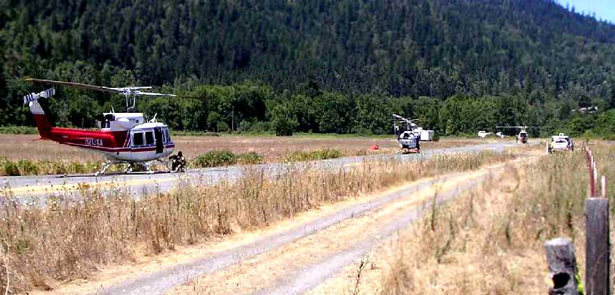
A 2006 photo by Gene Roberts looking north at several Bell 212/205 helicopters on the Willow Creek runway,
while they were part of firefighting operations during the Orleans Complex Fire.
Gene reported, “The Willow Creek Airport strip is often used as a helicopter base when local fires occur.
The grass field to the west of the runway is also used to park helicopters when it is used for this purpose.
I was a Fire Captain with CDF, one of my Incident Command System qualifications was a Call When Needed Helicopter Manager,
and I was managing a Bell 214ST & a UH-1H helicopter & spent 2 weeks at Willow Creek.
Having the river 50' away was a real temptation!”
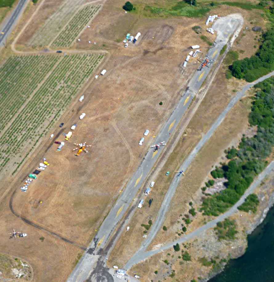
A 2009 aerial view by Roger Kubeck looking northwest at 5 helicopters on & around the Willow Creek runway,
including a Sikorsky/Erickson Skycrane at the north end.
Roger reported, “Notice the unusual runway markings are still visible.
I landed at Hoopa a few minutes after taking the pictures & that airport has the same yellow diamond markings.”
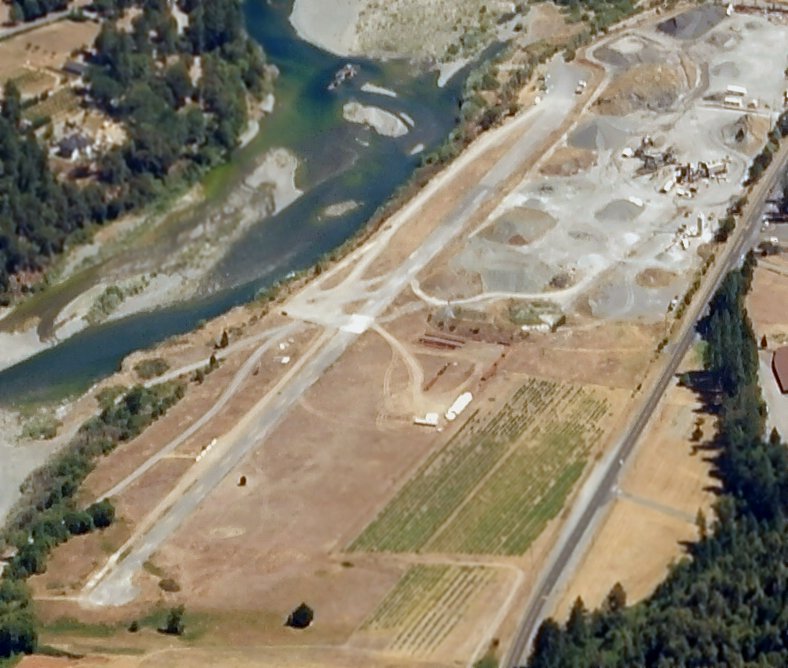
A 7/31/13 aerial view by Dallam Oliver-Lee looking south at the Willow Creek runway.
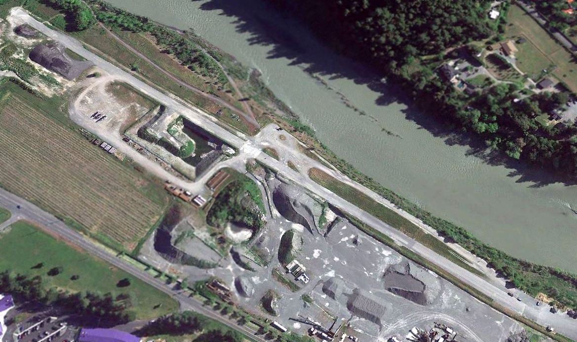
A 2019 aerial view looking northeast at Willow Creek Airport showed the runway remained intact, but the ramp had been covered by a gravel pile.
Willow Creek Airport is located adjacent to the east side of Route 96, a half mile north of Route 299.
____________________________________________________
Enterprise Sky Park (Q93), Redding, CA
40.58, -122.32 (North of San Francisco, CA)
Enterprise Sky Park, as depicted on the May 1966 Mt. Shasta Sectional Chart (courtesy of Chris Kennedy).
This small general aviation airfield was apparently built at some point between 1963-66,
as it was not listed among active airfields in the 1963 AOPA Airport Directory (according to Chris Kennedy)
nor depicted on the 1965 USGS topo map.
The earliest reference to Enterprise Sky Park which has been located
was on the May 1966 Mt. Shasta Sectional Chart (courtesy of Chris Kennedy).
It depicted the field as having a 3,100' unpaved runway.
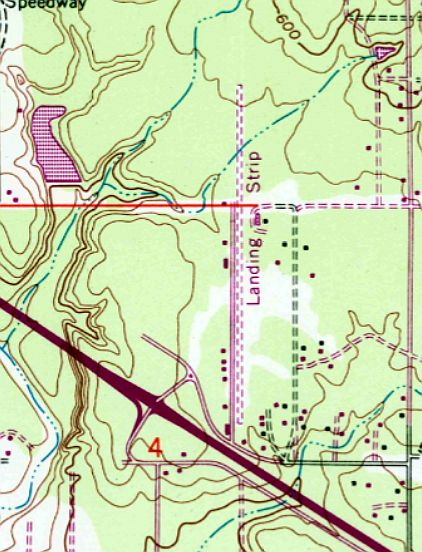
The 1969 USGS topo map depicted a single north/south runway, labeled simply as “Landing Strip”.
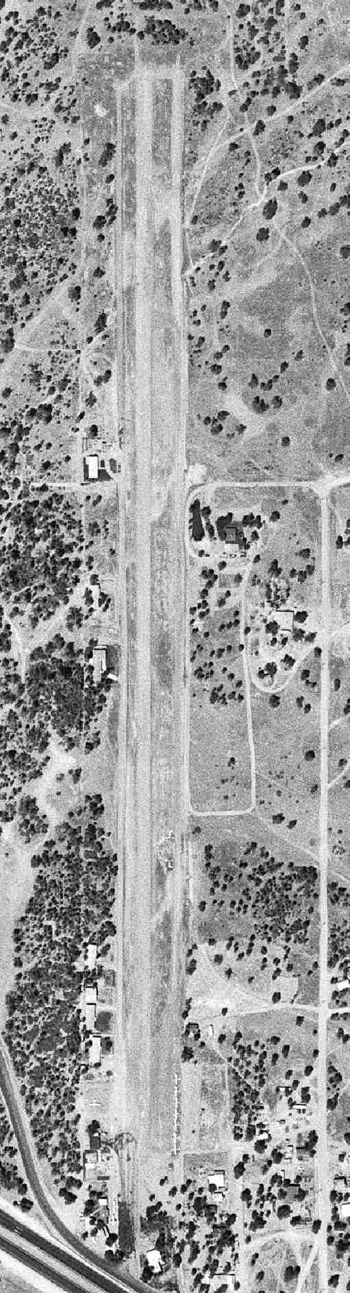
The earliest photo which has been located of Enterprise Sky Park was a 7/31/69 USGS aerial view,
which depicted the field as having a single north/south runway, with 8 light aircraft visible around the south end of the runway.
The last aeronautical chart depiction which has been located of Enterprise Sky Park was on the November 1971 Klamath Falls Sectional Chart,
which depicted the field as having a 2,900' paved north/south runway.
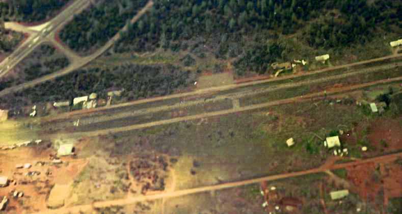
A July 1977 aerial view by Charles Seevers, looking west at the southern end of Enterprise Sky Park,
with Route 44 in the upper left corner, and several light planes visible on the field.
Charles recalled, “I was a member of the Enterprise Flying Club [from] 1975-1982.
Those were fun times & some of the best years for general aviation.”
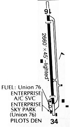
A 1984 airport directory (courtesy of Kevin Walsh) depicted Enterprise as having a single 2,660' paved Runway 16/34, with a parallel taxiway to the east,
and several small buildings on the southwest & southeast sides.
The 1984 USGS topo map continued to depict a single north/south runway, labeled simply as “Landing Strip”.
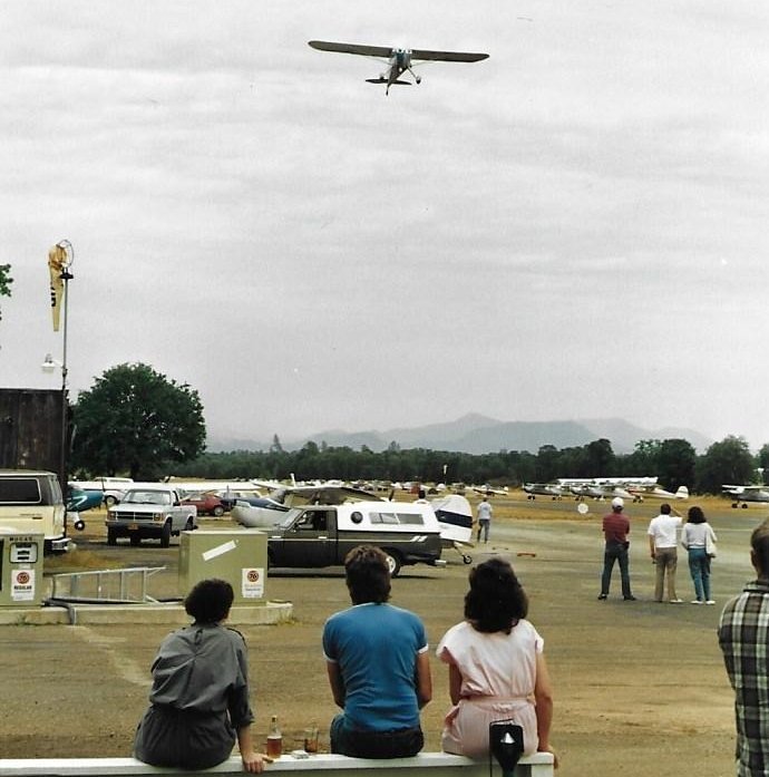
The last photos which has been located showing Enterprise Sky Park in operation were a series of 1987 photos by John Guilmette of a Cessna 140 fly-in.
The last photos which has been located showing Enterprise Sky Park in operation were a series of 1987 photos by John Guilmette of a Cessna 140 fly-in.
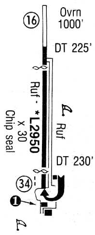
The 1993 Flight Guide (courtesy of Chris Kennedy) depicted the Enterprise Sky Park
as having a single 2,950' paved Runway 16/34, with an additional 1,000' overrun on the north end.
A ramp was located at the south end of the runway, around which were located three buildings,
which housed the Enterprise Fly Club & Gloria's Runway Café.
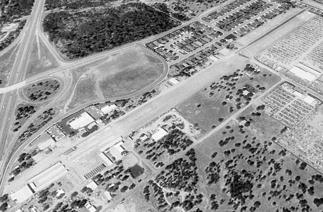
Enterprise Sky Park apparently closed at some point between 1993-98,
as a 1998 USGS aerial view looking northwest depicted that a road had been built over the northern portion of the former runway.
Several former hangars apparently still remained, at the south end of the former runway.
Enterprise Sky Park was definitely closed by 2000,
as it was not listed among active airfields in the 2000 AOPA Airport Directory.
Although the specific reason for the field's closure has not been determined,
it appears to have been squeezed out by new residential development which have surrounded it,
an all-too-common fate for small general aviation airports.
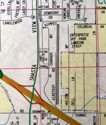
“Enterprise Sky Park Landing Strip” was still depicted on a 2001 street map (courtesy of Kevin Walsh),
even though it had evidently been closed for at least a year by that point.
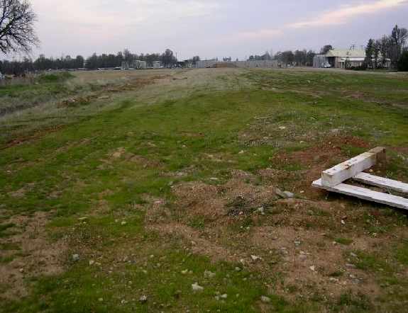
A 2004 photo by Dann Shively looking south down the former runway from Airstrip Road & Viking Drive.
Dann Shively reported in 2004, "I swung by the old Enterprise Sky Park to see how things looked.
In the aerial photo from 1998 you can see a street covering part of the north end of the runway.
That area is now developed with houses sitting on the property.
The tiny stretch of street running east & west is Viking Drive
and now continues, paved, to the east with more houses.
From that cross street (Viking Drive) south, the property & former runway is undeveloped
until the south end where there is a mini storage facility.
Part of that facility shows up on the aerial photo although it's now developed more."
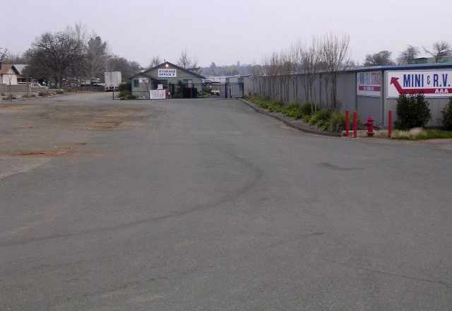
A 2004 photo by Dann Shively of the storage facility at the south end of the field looking north.
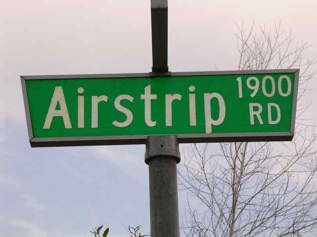
A 2004 photo by Dann Shively of a street sign for Airstrip Road.
"Airstrip Road ran north/south parallel to the runway on the west side when the airport was in operation.
It was just a gravel road & remains so today until the north end where it's paved where the houses are."
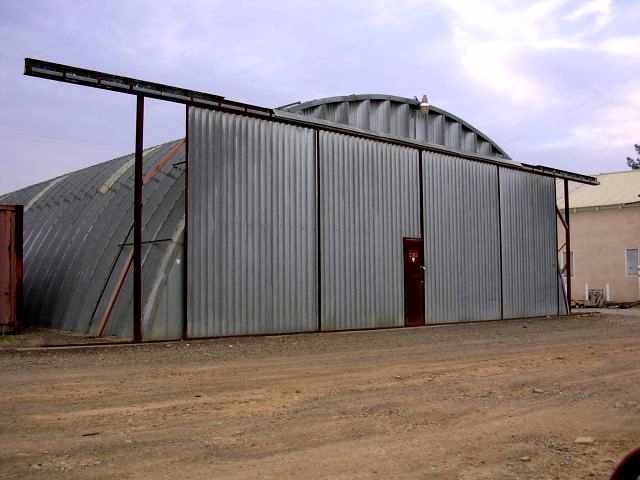
A 2004 photo by Dann Shively of one of the remaining former hangars on the west side of the former Enterprise Sky Park.
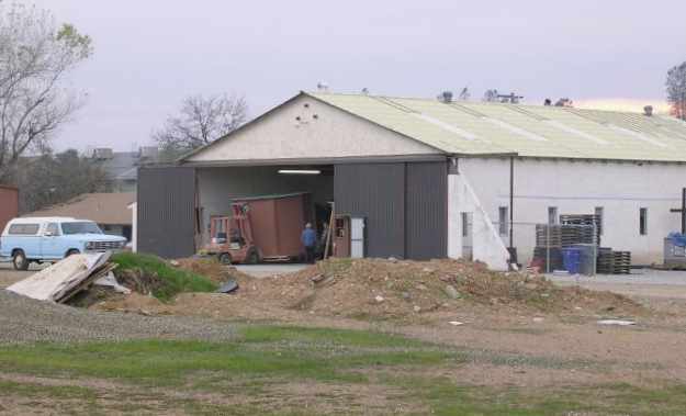
A 2004 photo by Dann Shively of one of the remaining former hangars on the west side of the former Enterprise Sky Park.
Dan reported, "There are still several hangars standing on the west side but are now used for other businesses.
Interestingly just on the south side of the property on the approach to what was Runway 34,
there are still some warning balls on the power lines that cross east to west."
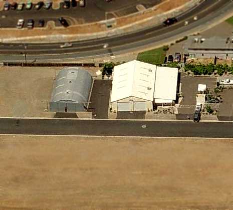
A circa 2006 aerial view looking west at 2 former hangars at the site of Enterprise Sky Park.
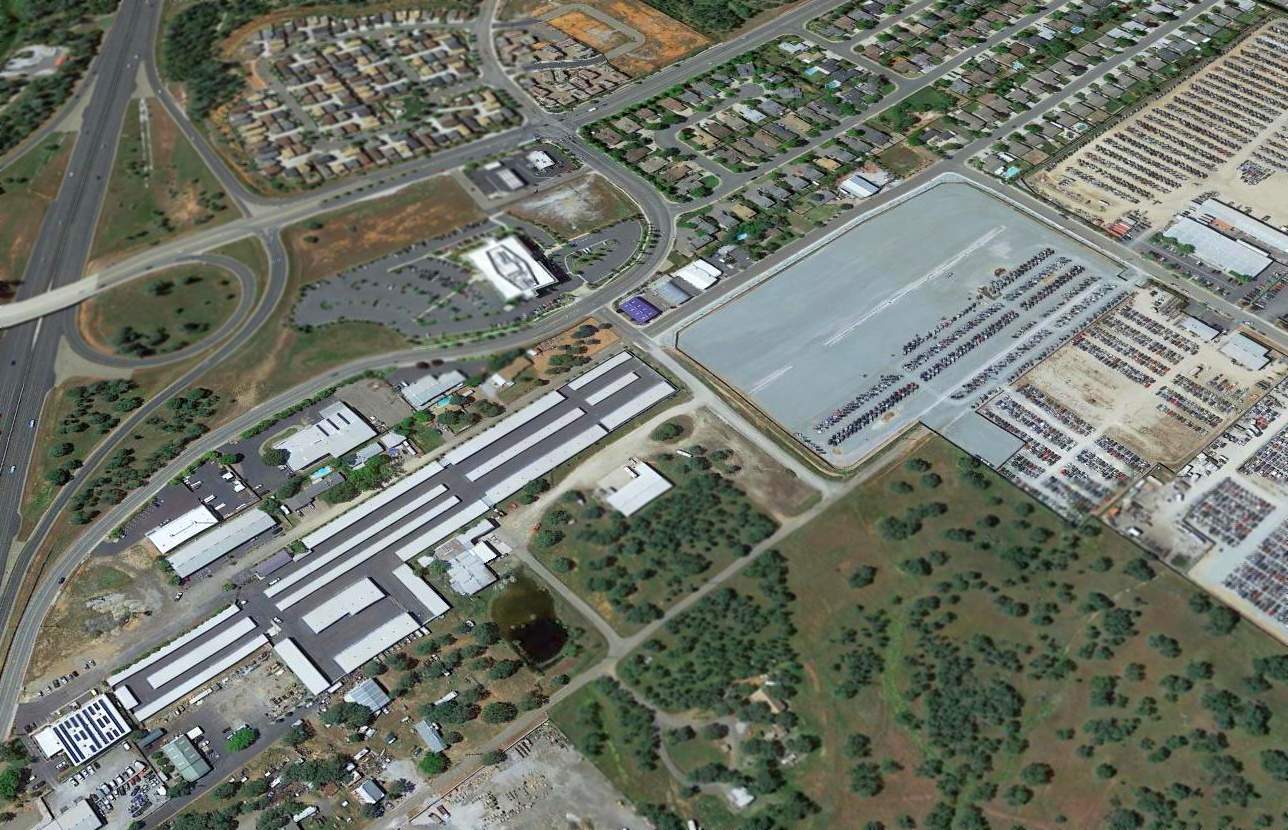
A 2015 aerial view looking northwest showed the site of Enterprise Sky Park was no longer recognizable as a former airfield.
The site of Enterprise Sky Park is located north of the intersection of Tarmac Road & Airstrip Road,
appropriately enough.
____________________________________________________
Redding Sky Ranch (O74), Redding, CA
40.5, -122.38 (North of San Francisco, CA)
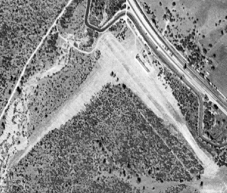
Redding Sky Ranch, as depicted on a 9/29/48 USGS aerial photo.
This small general aviation airfield was apparently built at some point between 1945-48,
as it was not depicted on a 10/1/43 USGS aerial photo nor on the 1945 Mt Shasta Sectional Chart (courtesy of John Voss).
The earliest photo which has been located of Redding Sky Ranch was a 9/29/48 USGS aerial view.
It depicted Sky Ranch as having 2 runways with a small building on the east side.
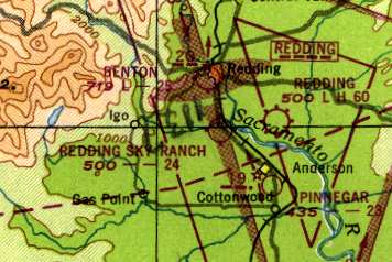
The earliest aeronautical chart depiction which has been located of Redding Sky Ranch
was on the 1948 Mt Shasta Sectional Chart (according to Chris Kennedy),
which described the field as having a 2,400' unpaved runway.
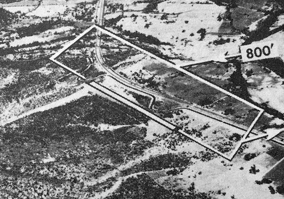
The last photo which has been located showing Redding Sky Ranch still in operation was an undated aerial view looking north from the 1950 Air Photo Guide (courtesy of Kevin Walsh).
The guide described Redding Sky Ranch as having a 2,400' gravel Runway 12/20.
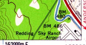
The 1957 USGS topo map depicted Redding Sky Ranch Airport as having 2 runways, with a building on the east side.
The 1962 AOPA Airport Directory described the Redding Sky Ranch
as having 2 runways (12/30: 2,700' road mix & 4/22: 2,100' bare),
and listed the operator as Baker Aircraft Sales.
The last aeronautical chart depiction which has been located of Redding Sky Ranch was on the November 1971 Klamath Falls Sectional Chart,
which depicted the field as having a 2,400' paved northwest/southeast runway.
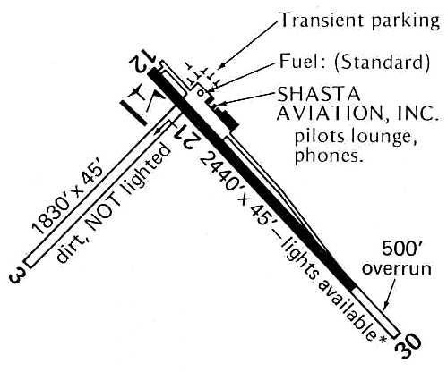
The 1976 Pilot's Guide to CA Airports (courtesy of Chris Kennedy)
depicted Redding Sky Ranch as having a 2,440' paved Runway 12/30 (which also had a 500' overrun)
and a 1,830' dirt Runway 3/21.
A parallel taxiway along the northeast side of Runway 12/30 led to a ramp with several hangars,
including the facilities of Shasta Aviation Inc.
In the 1982 AOPA Airport Directory (courtesy of Ed Drury),
Runway 12/30 was a 2,200' asphalt strip, and Runway 3/21 was an 1,800' gravel strip.
The operator was listed as North Star Aviation.
Redding Sky Ranch closed [for reasons unknown] in 1993.
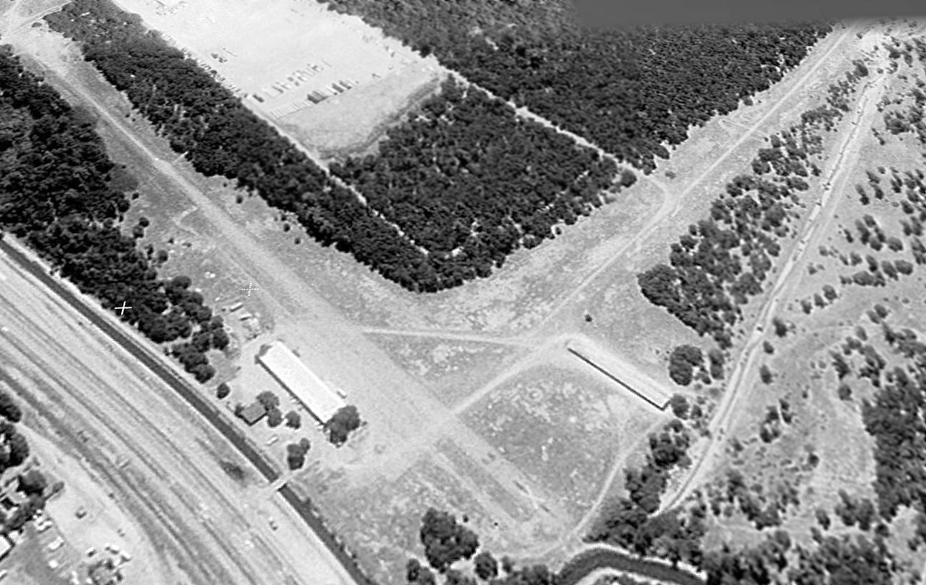
A 1998 USGS aerial view looking south at the site of Redding Sky Ranch
showed both runways still existed (with closed runway "X" markings on the paved runway), and 2 hangars still stood north of the runways.
The Redding Sky Ranch was no longer depicted at all (even as an abandoned airfield) on 2002 aeronautical charts.
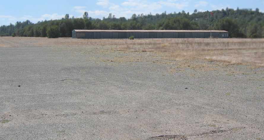
A September 2005 photo by James Douglas looking west at the long T-hangar
which remains in very decent condition at the former Redding Sky Ranch.
Note the windsock on the right side.
James Douglas visited the site of the Redding Sky Ranch in September 2005.
He reported, “ talked to some people who told me a little about the place.
It seems a local that owns a couple of roofing or electrical supply business & is quite well-heeled owns the land.
The city boundary is right up against the northern property line.
The extended centerline of Runway 30 has an Indian casino a few thousand feet dead ahead.
This could be a great place, but it will never happen.”
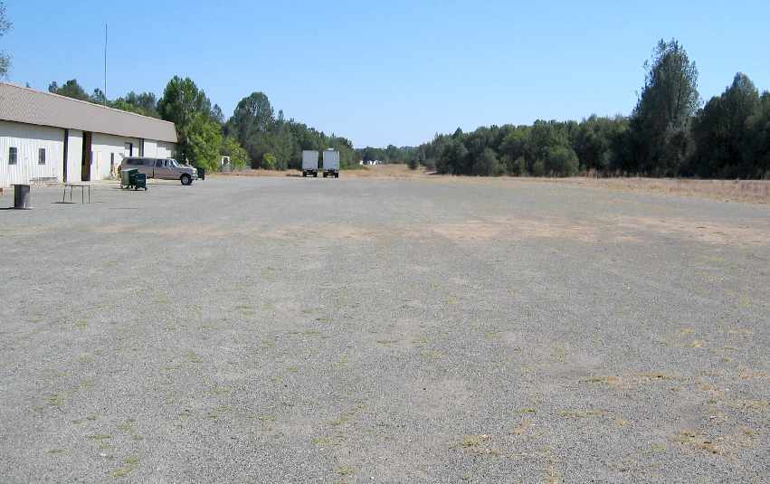
A September 2005 photo by James Douglas looking southeast along the former Runway 12,
with the former airport office building on the left.
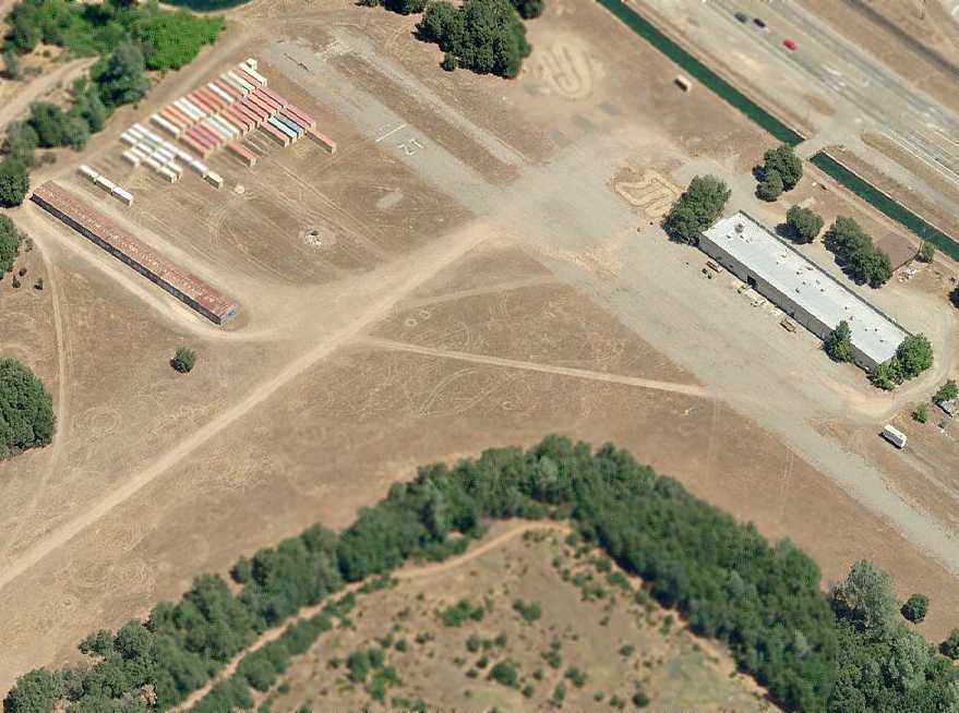
A circa 2006 aerial view looking north at the remains of the Redding Sky Ranch.
Both runways still existed (with markings on the paved runway), and the hangar & airport office building still stood.
Shipping containers were stored just northwest of the runway intersection.
It was reported in 2006, “The Redding Sky Ranch is now being used by a model airplane hobby/shop club.
These guys pay a fee to the club & use the old airstrips to fly planes & helicopters.”
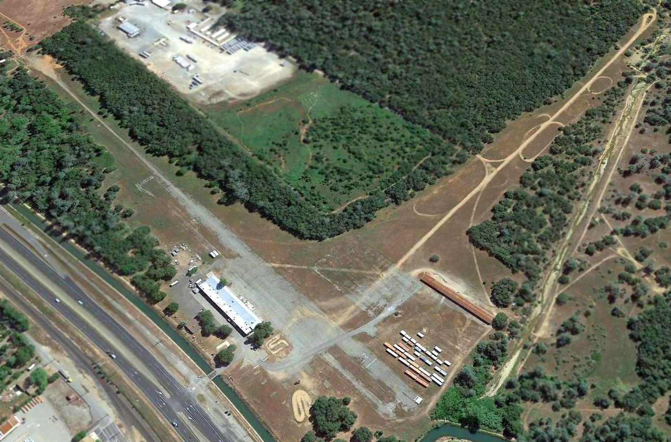
A 2015 aerial view looking south at the site of Redding Sky Ranch
showed both runways still existed (with runway markings still visible on the paved runway), and 2 hangars still stood north of the runways.
The site of Redding Sky Ranch is located south of the intersection of Route 273 & Canyon Road, south of the town of Girvan.
____________________________________________________
Stubbs Airport / Clear Lake Oaks Airport, Clearlake, CA
39.02, -122.66 (North of San Francisco, CA)
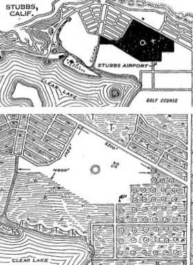
Stubbs Airport, as depicted in a 1930 Department of Commerce Airway Bulletin (courtesy of Jonathan Westerling).
Photo of the airport while open has not been located.
The date of construction of this early general aviation airfield has not been determined.
The earliest depiction which has been located of the Stubbs Airport
was in the 1930 Department of Commerce Airway Bulletin (courtesy of Jonathan Westerling).
It described the Stubbs Airport as a commercial field, owned & operated by the Stubbs brothers.
The field was described as an irregularly-shaped 109 acre sod field, with a 4,000' east/west landing area.
The field was said to not have any hangars.
In 1935 the town of Stubbs had its name changed to Clearlake Oaks,
according to “California’s Geographic Names” (courtesy of Jonathan Westerling).

The earliest aeronautical chart depiction which has been located of Stubbs Airport was on the May 1936 Sectional Chart.
It depicted Stubbs as a commercial/municipal airport located adjacent to the east side of the town of Clear Lake Oaks, on the shore of Clear Lake.
The Airport Directory Company's 1937 Airports Directory (courtesy of Bob Rambo)
described the Stubbs Airport as having an irregularly-shaped 109 acre sod field with a 4,000' runway.
![]()
Stubbs Airport was evidently renamed Clear Lake Oaks Airport at some point between 1937-39,
as that is how it was labeled on the 1939 Sectional Chart (courtesy of Dann Shively).
Ironically the adjacent town had also been renamed to Clear Lake Oaks.
The Clear Lake Oaks Airport was apparently closed during WW2
(due to wartime security concerns, like many other small civilian airports along the coasts during the war),
as it was not listed in the Airport Directory Company's 1941 Airport Directory (according to Chris Kennedy),
depicted on the November 1941 Sacramento Sectional Chart,
depicted on the 1942 USGS topo map, or listed in the April 1944 US Army/Navy Directory of Airfields (courtesy of Ken Mercer).
Unlike many other fields for which their wartime closures were temporary,
Clear Lake Oaks Airport apparently never reopened after the war,
as it was not depicted on the 1946 Sectional Chart (according to Dann Shively) or subsequent charts.
A 1956 aerial photo showed no remaining recognizable trace of Clear Lake Oaks Airport.
In the 1950s & 1960s, a residential development called the Clear Lake Keys was developed along the shore of Clear Lake,
in which land was dredged out creating canals where homeowners could dock their boats.
The airport site remained an undeveloped meadow adjacent to the east side of the Clear Lake Keys.
A 1998 USGS aerial photo showed the site of Clear Lake Oaks Airport to remain an open meadow.
![]()
A 2004 photo by Dann Shively of the empty meadow adjacent to the east side of the Clear Lake Keys development,
which may be the site of the former Clear Lake Oaks Airport.
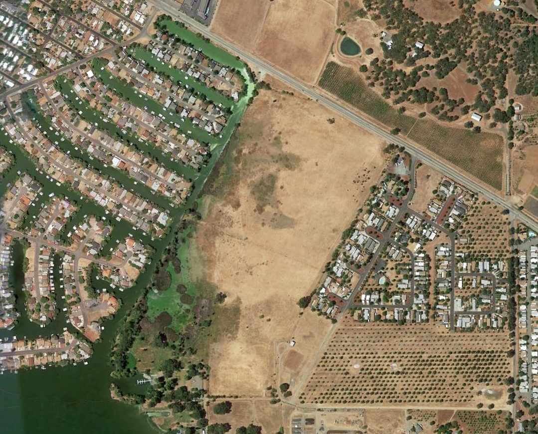
A 2013 aerial view showed the site of Clear Lake Oaks Airport to remain an empty meadow.
The site of Clear Lake Oaks Airport is located south of the intersection of Route 20 & Keys Boulevard.
Thanks to Dann Shively for pointing out this field.
____________________________________________________
____________________________________________________
This site covers airfields in all 50 states.