
Abandoned & Little-Known Airfields:
California: Central Orange County
© 2002, © 2026 by Paul Freeman. Revised 1/21/26.
This site covers airfields in all 50 states: Click here for the site's main menu.
____________________________________________________
Please consider a financial contribution to support the continued growth & operation of this site.
For a 10th year, the CA pages of this website are sponsored by the California Pilots Association:
Eddie Martin Airport (revised 10/16/19) - Luebkeman Airport / Anaheim Airport / NOLF 02604 (revised 1/21/26)
Naval Outlying Landing Field 13207 / Mile Square NOLF (revised 8/5/19) - Newport Bay Sky Harbor Airport / Balboa Airport / Balboa Bay Airport (revised 7/20/24)
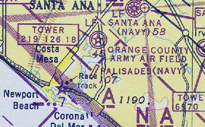
Palisades NOLF (revised 8/5/19)
____________________________________________________
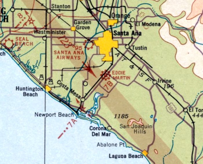
Eddie Martin Airport, Santa Ana, CA
33.69, -117.87 (Southeast of Los Angeles, CA)
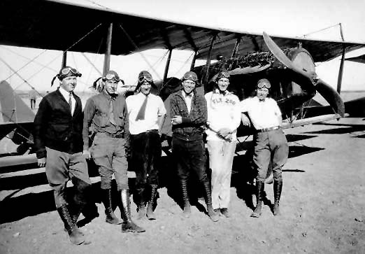
An undated photo of several early pilots gathered in front of an unidentified biplane at Martin Field:
Howard Maish, George Leonard, Ernie Mobbs, John Martin, Harry Menephy, and Eddie Martin.
Aviation pioneer Eddie Martin started giving biplane rides in 1923
on land owned by The Irvine Company, initially without their permission.
Later that same year, Eddie & James Irvine made a deal for a 5-year lease on 80 acres for $35 a month.
In 1924 Eddie began the Santa Ana Air Club to promote flying in Orange County.
The organization was active for several years, eventually changing its name to the Eddie Martin's Pilot's Association.
Eddie taught many local people to fly.
Up until 1925 all of his pupils were males until Peggy Hall, a pretty young Santa Ana woman,
became the first woman to take lessons at the airport.
She developed her talents & became accomplished at acrobatics, sometimes appearing in air shows.
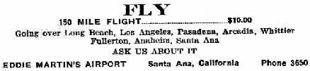
An undated (circa 1920s) ad for Eddie Martin's Airport.
It was in 1926 that Eddie was finally able to acquire a hangar for his airport.
It was a portable wooden building which sold for $350.
Later another portable hangar & two large permanent hangars were built.
Eddie and Johnny both took full-time jobs in aviation,
and left the running of the airport to Floyd Martin, their younger brother.
Carl Watson reported, “My father in law lived with his parents who had a store close to the old Eddie Martin Field
which was not where John Wayne Airport sits today.
His father Clearence Forsberg use to operate a store & he would sell peanuts when they had air shows there.
One that he mentions is when they put a parachute on a biplane & let it settle back to the ground.
He lived there from about 1920's to some time in the late 1920's.”
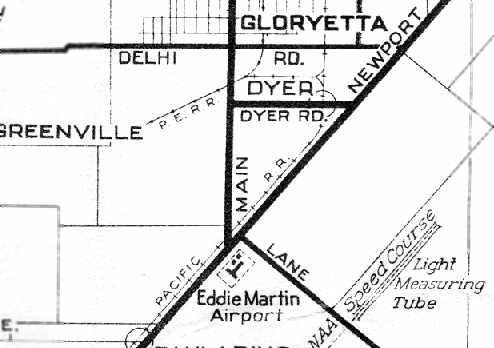
The earliest dated depiction of Martin Airport which has been located
was on a 1929 AAA street map (courtesy of Dan MacPherson).
It depicted Eddie Martin Airport as having 2 runways (oriented northwest/southeast & northeast/southwest),
with 2 buildings on the north side of the field.
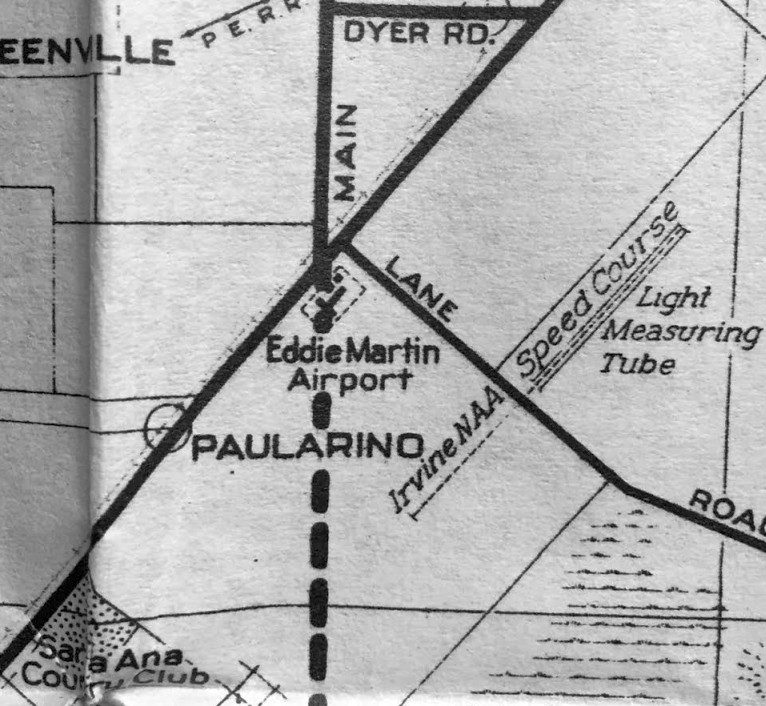
The field was depicted as a rectangular property, located south of the intersection of Newport Avenue & Main Street.
Eddie Martin Field added runway lights in 1930.
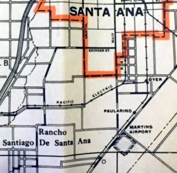
A 1930 LA County Rand McNally street map (courtesy of Kevin Walsh) depicted “Martins Airport” as a square property outline.
The earliest aeronautical chart depiction of Eddie Martin Airport which has been located was on the February 1934 San Diego Sectional Chart.
It depicted Eddie Martin as a commercial field.
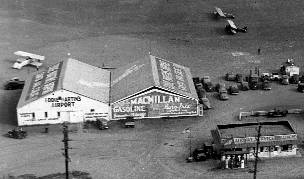
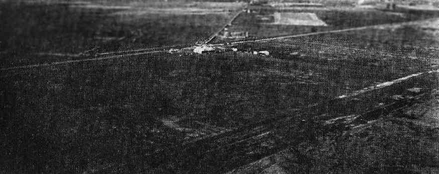
A circa 1930s aerial view of several hangars & 3 biplanes at Eddie Matin's Airport.
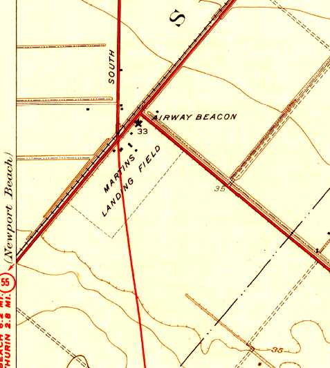
The earliest topo map depiction of Martin Airport which has been located was on the 1935 USGS topo map.
It depicted “Martin's Landing Field” as a rectangular property with several buildings & an airway beacon at the north end.
A circa 1935-36 sttreet map (courtesy of Kevin Walsh) depicted Eddie Martin Airport as a rectangular property outline with 2 buildings on the north end.
An undated aerial view looking northwest at “Martin's” Airport,
from The Airport Directory Company's 1937 Airport Directory (courtesy of Bob Rambo).
The directory described Martin's as a commercial field, consisting of a rectangular sod field,
measuring 2,040' x 1,320', with the entire field available for flight operations.
A hangar was said to have “Eddie Martin's Airport” marked on its roof.
The field was illuminated, and was said to offer service, day & night.
An 8/9/38 aerial view of Eddie Martin Field (from the UCSB Library) depicted it as a rectangular grass field,
with 2 light single-engine aircraft visible next to a few small buildings on the north corner,
A 1940 Shell street map (courtesy of Gary Alexander) depiced Eddie Martin's Airport
as an irregularly-shaped outline on the southeast side of Newport Avenue.
The last depiction of Eddie Martin Airport which has been located was on the August 1940 San Diego Sectional Chart.
It depicted Eddie Martin as a commercial field.
At some point between 1940-41, the new Orange County Airport was established on land adjacent to Martin Field, to the south.
The two fields were not located on the same property, as has been repeated elsewhere.
But flight operations at the new Orange County Airport probably resulted in the closure of Martin Field at this point.
By the time of the December 1941 San Diego Sectional Chart,
Eddie Martin Field was no longer depicted, only the new Orange County Airport adjacent to the south.
A 1946 aerial view showed that a new road had been cut through the eastern portion of the former Martin Field,
and its buildings had been removed.
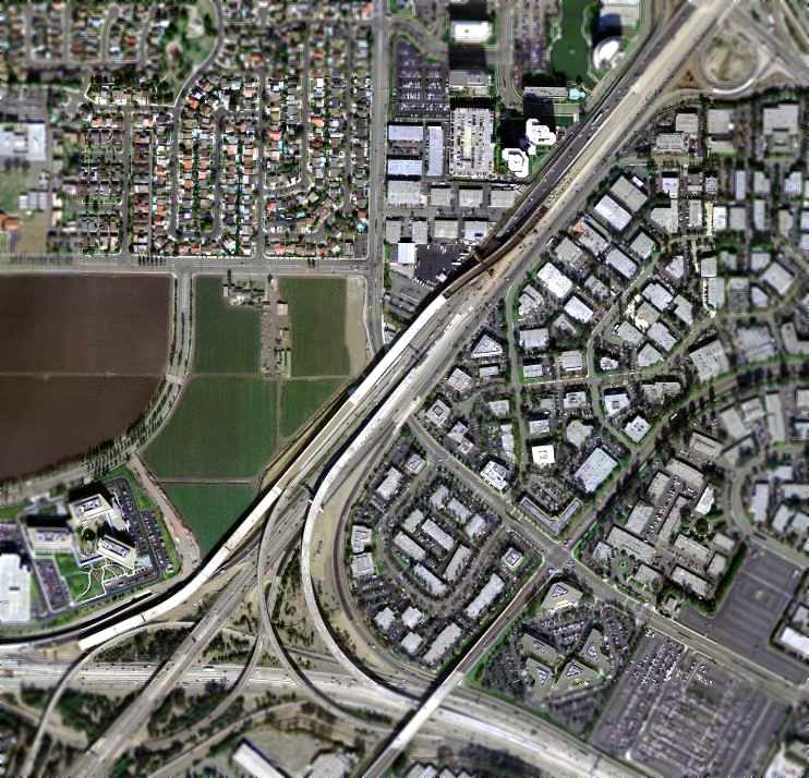
As can be seen in a 2004 USGS aerial photo, not a trace remains of Eddie Martin Airport.
The site of Eddie Martin Airport is located at the intersection of Route 55 & South Main Street,
just north of John Wayne Airport.
____________________________________________________
Newport Bay Airport / Sky Harbor Airport / Balboa Airport / Balboa Bay Airport, Costa Mesa, CA
33.65, -117.94 (Southeast of Los Angeles, CA)
Newport Bay Airport, as depicted on the 1947 LA Local Aeronautical Chart (courtesy of Tim Zukas).
No airport was yet depicted at this location on a 1938 aerial photo.
This small airport was one of a huge number of general aviation airports which sprung up around the United States in the immediate aftermath of the Second World War.
However, it lasted a mere 7 years, having the 'misfortune' to be located on real estate which eventually became 'too valuable'
to continue to be used as a general aviation airport.
According to Edrick Miller’s book "A Slice of Orange" (courtesy of Jerome Vandewalle),
three former Army Air Force pilots (Gilmer Mayfield, Thomas Murphy, and M. R. Conn)
announced their intention of establishing an airport in Costa Mesa in February 1946.
They planned to establish a 214-acre airport on land leased from George Capron.
The plan drew strong objections from the local Chamber of Commerce, but differences were eventually resolved.
The Airport had apparently commenced operations within the next few months,
as the 7/25/46 issue of the Newport News - Balboa Times reported that flights were "being conducted out of the airport daily",
using a Ryan PT-22, Fairchild PT-19, Vultee BT-13A, Taylorcraft, Globe Swift, Aeronca, Piper Cub, and Stinson L-5.
Gilmer Murphy, one of the 3 founders of the airport, was President of Pacific Coast Airways.
The first runway was described as running east/west, paralleling 19th Street.
A small 2-story building about halfway down the runway served as the administration building.
The 2nd floor had glass on 3 sides, and served as a control tower.
The airport was reported to be completing its north/south runway & its hangar within 10 days.
Newport Bay Airport was not yet depicted on the August 1946 San Diego Sectional Chart.
By September 1946, the Costa Mesa Globe Herald (from the Costa Mesa Historical Society, courtesy of Jerome Vandewalle) described "Sky Harbor" as "a busy place".
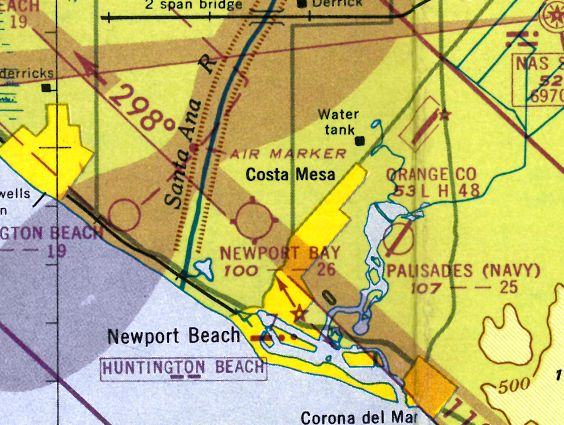
The earliest depiction which has been located of Newport Bay Airport was on the 1947 LA Local Aeronautical Chart (courtesy of Tim Zukas).
It depicted Newport Bay Airport as having a 2,600' unpaved runway.
The 1947 USGS topo map labeled the field as “Newport Bay Sky Harbor”, but curiously omitted the actual airfield circle symbol.
The 1948 San Diego Sectional Chart (according to Chris Kennedy) depicted Newport Bay Airport as having a 2,600' unpaved runway.
Newport Bay Airport's runway was apparently paved within the next year, and the airport renamed,
it was labeled "Balboa Bay" Airport on the 1949 San Diego Sectional Chart (according to Chris Kennedy),
and described as having a 2,700' hard-surface runway.
The 1949 USGS topo map (courtesy of Kevin Walsh) depicted "Balboa Airport" as having 2 runways:
a 2,800' north/south runway & a slightly shorter east/west runway.
Balboa Airport was depicted similarly on the 1950 USGS topo map (courtesy of Scott O'Donnell).
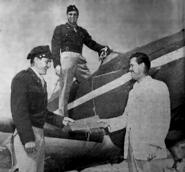
A photo from the 5/13/49 issue of the Costa Mesa Globe Herald (from the Costa Mesa Historical Society, courtesy of Jerome Vandewalle).
The photo depicted the Balboa Bay Squadron of the Civil Air Patrol
taking possession of its third plane (type undetermined) at the "Costa Mesa Airport".
Pictured is O.V. Bracken (at left, the squadron commanding officer)
receiving the papers from the aircraft from seller Tom Harris (who was also the executive officer of the squadron).
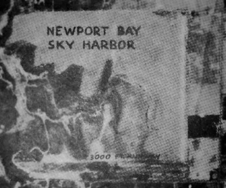
An undated photo (from the Costa Mesa Historical Society, courtesy of Jerome Vandewalle) of the "Newport Bay Sky Harbor" Airport.
A 3,000' runway is depicted along the southern edge of the property.
The last aeronautical chart depiction which has been located of this airfield was on the March 1952 San Diego Sectional Chart.
It depicted Balboa Bay Airport as having a 2,600' unpaved runway.
Balboa Bay Airport was evidently closed at some point between 1952-53,
as a 1953 aerial view showed that the 2 runways remained intact, along with some small buildings along the south side of the field,
but the airport otherwise appeared vacant, soon to be redeveloped.
Balboa Bay Airport was no longer depicted on the March 1953 San Diego Sectional Aeronautical Chart.
According to Edrick Miller’s book "A Slice of Orange" (courtesy of Jerome Vandewalle),
Balboa Bay Airport "was torn up in early 1953 to make way for the huge Newport Vista housing tract.
A 1955 aerial photo (from the Costa Mesa Historical Society, courtesy of Jerome Vandewalle) showed the Balboa Bay Airport site had been densely covered with houses,
with not a trace remaining of the former airport.

A 2023 aerial photo showed that the site of Balboa Airport had been densely redeveloped with housing, and not a trace of the former airport appeared to remain.
The site of Balboa Airport is located southwest of the intersection of Victoria Street & Placienta Avenue.
Thanks to Francis Blake for pointing out this airfield.
____________________________________________________
Luebkeman Airport / Anaheim Airport / Naval Outlying Landing Field 02604, Anaheim, CA
33.84, -118.02 (Northeast of Long Beach, CA)
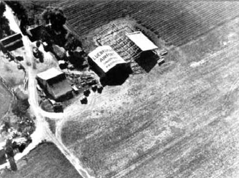
An undated (circa 1930s-40s) aerial view of a hangar with “Luebkeman Airport” painted on the roof,
with what appears to be an adjacent slightly larger hangar under construction.
Anton Luebkeman & his wife came to California to Germany in 1904 & bought 104 acres of land in Buena Park in 1910.
In 1935 the Luebkeman family bought another 100 acres, on which they built an airfield in 1938.
They rented hangar space to area flyers, including eventual billionaire Howard Hughes.
According to the Army Corps of Engineers, the Luebkeman Airport initially had a grass 2,200' east/west runway.
Luebkeman Airport provided basic flight training under the Civilian Pilot Training Program beginning in 1939.
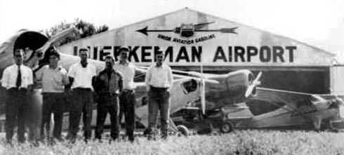
An undated (circa 1930s-40s) photo of an unidentified group in front of a Luebkeman Airport hangar,
along with several single-engine taildraggers.
The earliest aeronautical chart depiction which has been located of Luebkeman Airport
was on the August 1940 San Diego Sectional Chart (courtesy of Chris Kennedy).
It depicted Luebkeman as a commercial/municipal airport.
A 1940 photo showing the filming of the movie The Great American Broadcast at Luebkeman Airport, with a hangar in the background.
The airport was rented by 20th Century Fox Studios for 5 days for filming.
The June 1941 San Diego Sectional Chart (according to Chris Kennedy)
continued to depict Luebkeman as a commercial/municipal airport.
By 1941, the airport reportedly had 2 hangars & 6 runways
(which seems excessive – this may actually have been referring to 3 runways).
The name of the airport was changed in 1941 to Anaheim Airport through the encouragement of the Anaheim Chamber of Commerce,
which was investigating the business potential of the site.
The airport was not listed in airport directories of the time.
The last aeronautical chart depiction which has been located of Anaheim Airport
was on the October 1941 LA Sectional Chart (courtesy of Chris Kennedy).
It depicted Anaheim as a commercial/municipal airport.
Civilian use of Anaheim Airport evidently ended upon the declaration of War in December 1941.
The last photo which has been located of Anaheim Airport still intact was a 2/28/42 USGS aerial view (from the UCSB Library).
It depicted Anaheim Airport as having a single unpaved east/west runway, with a few small hangars on the southeast side, on one of which was visible “Anaheim Airport”.
According to the Army Corps of Engineers, the Navy initiated a lease of the Anaheim Airport during or subsequent to 1942,
intending to use the airport as an auxiliary field to support the basic flight training of Navy pilots based at the Los Alamitos Naval Reserve Air Base, 5 miles southwest of the site.
No information has been found confirm actual Navy use of the property during the war.
A 1942 USGS topo map depicted an airport symbol at the site of Anaheim Airport, but curiously it was unlabeled.
A circa 1943 chart of NAS Los Alamitos & several of its outlying fields (courtesy of John Voss)
depicted the Anaheim Airport as “Proposed 02604” at the top.
According to the Army Corps of Engineers, the Navy terminated their lease of Anaheim Airport prior or during 1945.
No material was found to determine whether the Navy made any improvements to the site.
Anaheim Airport was not listed among active airfields in the 1945 AAF Airfield Directory (courtesy of Scott Murdock).
After WWII, the Luebkeman family did not reopen the airport.
The metal hangars were used for storage of farm equipment & cars.
A 1952 aerial view showed that the 2 hangars remained standing,
but there was no other recognizable sign of an airport.
A 1954 aerial view showed that the 2 hangars remained standing,
but residential streets had been laid out in the surrounding fields.
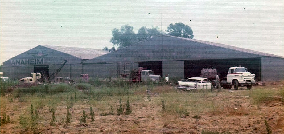
The last ground-level photo which has been located of any remains of Anaheim Airport was a circa 1960s photo of the hangars (courtesy of Douglas Marley), with the faded Anaheim Airport lettering still visible.
The last photo which has been located of any remains of Anaheim Airport was a 2/28/62 USGS aerial view, showing the former hangars remained intact (center of photo), surrounded by dense housing.
Jeannie Gillett reported, “My great-grandparents, Anton & Anna Luebkeman were the owners of the farmland where the airport was situated.
I believe the property borders were Knott Avenue & Walker Street, and Crescent Avenue & LaPalma Avenue.
I remember from my childhood is that my grandparents, Hank & Louise Luebkeman, lived on about an acre where they had a home, chickens, and a building we called the 'pump house'.
There were hangars there in the 1960s & 1970s, and they stored pottery from the pottery shop (next to the alligator farm) that was located across the street from Knott's Berry Farm.”
Shawn McBurney recalled, “I grew up in Buena Park, California in the 1960s & 1970s
in a subdivision bounded by Knott Avenue, La Palma Avenue, Crescent Avenue and Valley View Street.
Up until the mid-1970s, a portion of that area was a large field that had an old house on it.
In addition to the house, the property had a very large old metal building that had 'Anaheim Airport' painted on the roof in large faded lettering.
The building had very large doors as well.
The field was overgrown & strewn with various things (pieces of machinery, an old travel trailer, etc.).
In the mid-1970s, the field was developed with single-family homes.
However, the original old house remained
and was occupied by what we believed to be the owners of the property who sold the land to developers.
The property was bounded by Holder Street, San Capistrano Way, San Hernando Way, and Crescent Avenue
(although there was a church which is still there located in the southeast corner of the property on Crescent Avenue).
The old house was (and I believe still is) located just north of the church (on [an aerial] view it looks like a white 'L').
The large metal building was located just about where the cul-de-sac for San Gabriel Circle is now located
(San Gabriel Circle & San Simeon Circle were created in what was the field).”
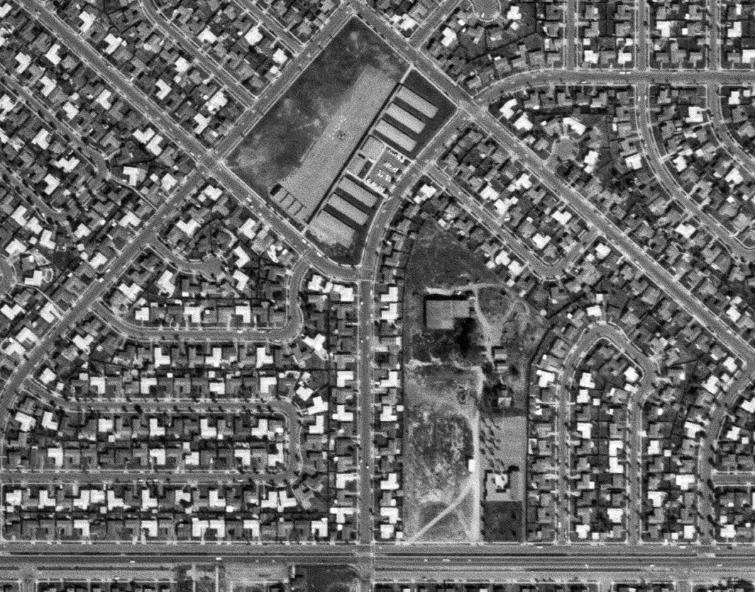
A 1972 aerial photo show the former Anaheim Airport hangars were gone, with the site covered by houses.
A 2007 aerial view shows the site of the Luebkeman/Anaheim Airport to be densely redeveloped with housing,
but the original house appears to remain just north of the church at the bottom-left.
Thanks to Shawn McBurney for pointing out this airfield.
____________________________________________________
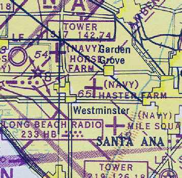
Naval Outlying Landing Field 13207 / Mile Square Naval Outlying Landing Field,
Garden Grove, CA
33.73, -117.94 (Southeast of Long Beach, CA)
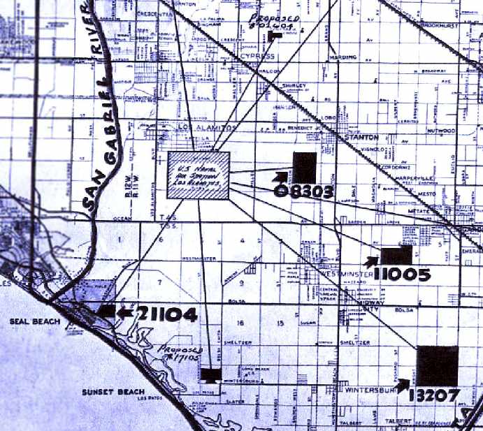
A circa 1943 chart of NAS Los Alamitos & several of its outlying fields (courtesy of John Voss),
including NOLF 13207 (Mile Square).
In 1942, the Navy obtained 640 acres of land for Naval Outlying Field Mile Square,
which used as an auxiliary for Naval Air Station, Los Alamitos.
It was used for carrier deck qualification practice by Navy aircraft.
Mile Square was originally one of 5 NOLFs which were closely located between Los Alamitos & El Toro:
the others were Horse Farm NOLF, Haster Farm NOLF, Seal Beach NOLF, and Palisades NOLF.
The earliest depiction which has been located of NOLF Mile Square
was a circa 1943 chart of NAS Los Alamitos & several of its outlying fields (courtesy of John Voss).
It depicted NOLF 13207 (Mile Square), as well as NOLF Haster Farm (11005), NOLF Horse Farm (08303),
NOLF Seal Beach (21104), and 2 “proposed” fields which were never built.
Brian Rehinkel observed, “When the field was originally acquired,
the mission of NAS Los Alamitos was primary training.
The original field was a asphalt-type [hexagonal] mat (very similar to the landing mats at OLF Haster Farm & OLF Horse Farm).
When the primary training mission ended in August 1943,
the station began to host Carrier Air Groups for training & the new runways were built on top of the 'old' mat.”
An early 1940s directory of airfields associated with NAS San Diego (courtesy of Brian Rehwinkel)
depicted both the short-lived original airfield configuration of Mile Square NOLF (a hexagonal landing mat)
as well as the eventual 3-runway layout.
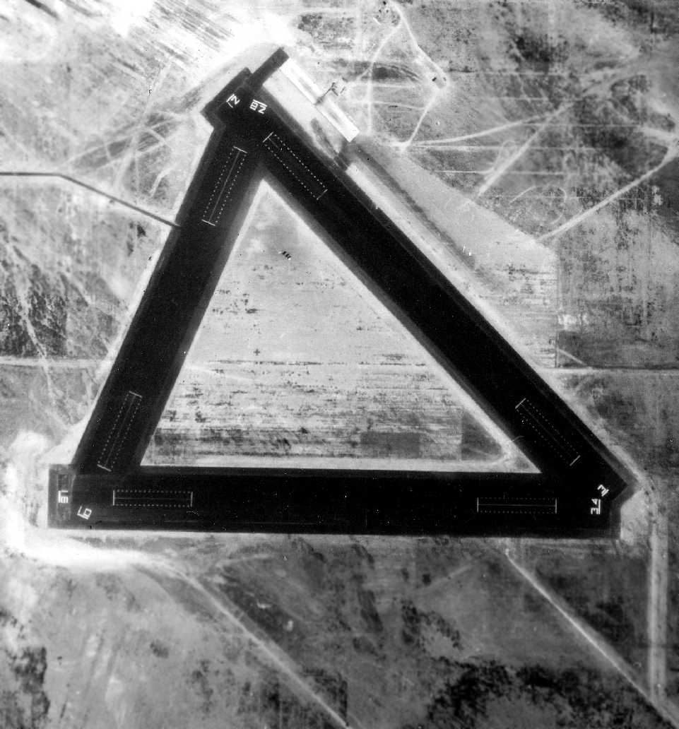
The earliest photo which has been located of Mile Square NOLF was a 9/21/43 aerial view (courtesy of Brian Rehwinkel).
Underneath the newly-constructed triangular layout of 3 asphalt runways, careful examination will reveal the outline (particularly on the northeast side)
of the original hexagonal landing mat.
Brian Rehinkel observed, “The name 'Mile Square' is unusual,
particularly when most of the Navy's OLF's were given names based on the primary land owner the field was acquired from (as in Haster Farm),
a geographical reference (as in Palisades), or a numerical designation (as in many of the fields in Corpus Christi).
Of course, Mile Square was named because it was nearly a full land section/1 square mile (I believe it was actually just over 631 acres).
I suspect the reason it was not named after a previous land owner
was that the land acquired was made up of 23 parcels - from 23 different land owners.”
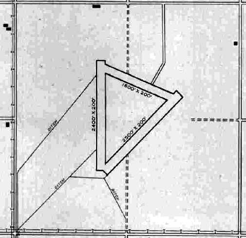
The 1945 AAF Airfield Directory (courtesy of Scott Murdock) described “Los Alamitos Field Auxiliary (13207 Mile Square Farm Outlying Field)”
as a 640 acre square property within which were 3 bituminous runways, the longest being the 2,500' northeast/southwest strip.
The field was said to not have any hangars.
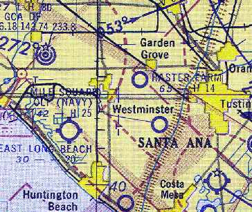
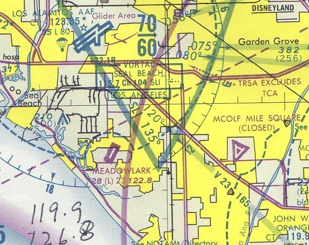
"(Navy) Mile Square", as depicted on the August 1945 San Diego Sectional Aeronautical Chart (courtesy of Chris Kennedy).
The 1947 USGS topo map labeled the field as “Mile Square Farm”.
The 1947 LA Local Aeronautical Chart depicted “Mile Square (Navy)” as having a 2,500' paved runway.
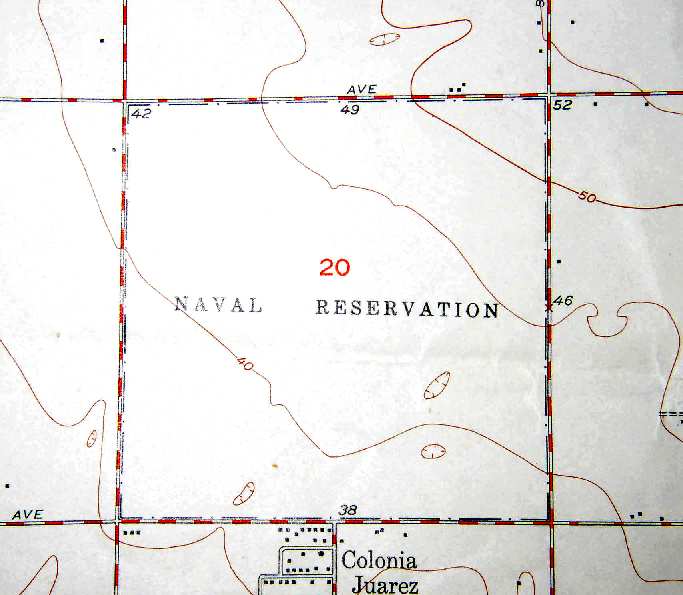
The 1951 USGS topo map (courtesy of Scott O'Donnell) did not depict any runways at all at Mile Square -
the property was labeled merely "Naval Reservation".
It is not known if the runways were built after 1951,
or simply omitted from the map.
A
1953 aerial view showed the 3 asphalt runways of Mile Square,
with an aircraft carrier landing area outline painted on each runway end.
The field was surrounded by empty farmland.
"Mile Square OLF (Navy)", as depicted on the September 1955 San Diego Sectional Chart (courtesy of Chris Kennedy).
In 1955, the facility was redesignated as a Marine Corps Outlying Landing Field,
to be used for helicopter autorotation practice
by helicopters based at nearby MCAF Santa Anna (later renamed MCAS Tustin).
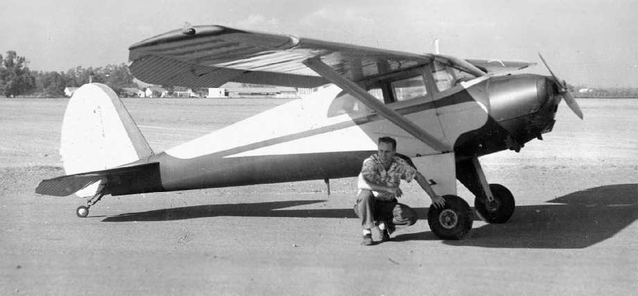
Bob Cannon in front of his Luscombe after landing at Mile Square in 1956.
However, Bob Cannon didn't think there was a lot of military activity at Mile Square in 1956,
as he landed his Luscombe "in June 1956 at the then open & unused Mile Square airport.
Note the lack of houses in the background."
"I went to land there one day & the Marines had a jeep cruising around it.
I made several low passes strafing the jeep; I mean ground level runs.
I have no idea at this time what ever possessed me to think that I could get away with it.
Maybe one pass & then scram, but no, I made several passes.
That night I got a call from some Lieutenant in the Navy or whatever asking me what was up.
I told him I guess I was just a frustrated fighter pilot wannabe.
He suggested that I come down & sign up.
I told him that I wasn't that frustrated. I got off with just a warning miraculously."
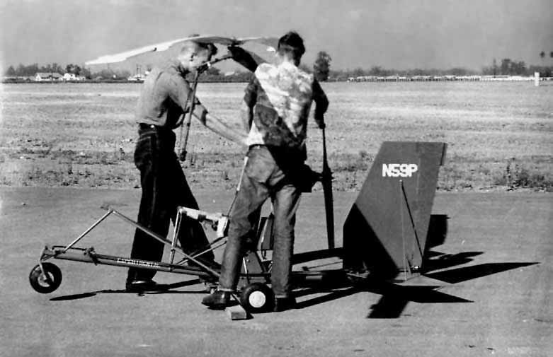
A circa-1950s photo by Bob Cannon of an autogiro being tested at Mile Square.
In 1959, the Navy leased approximately 500 acres to the Heil Ranch Partnership for agricultural purposes.
The Mile Square airfield was no longer depicted at all
on the September 1959 San Diego Sectional Aeronautical Chart (courtesy of Chris Kennedy).
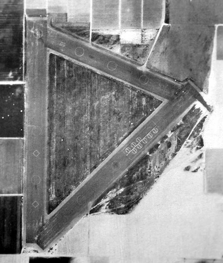
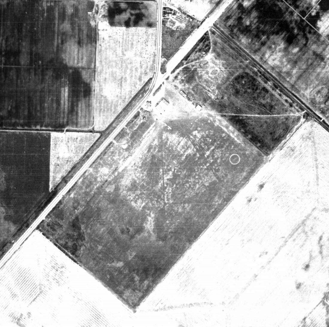
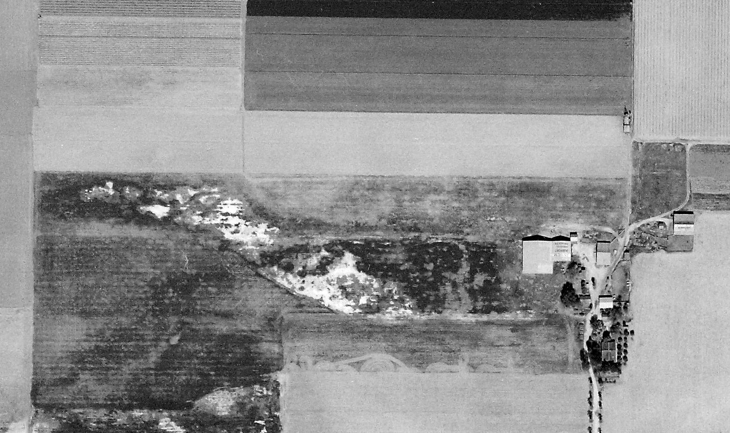
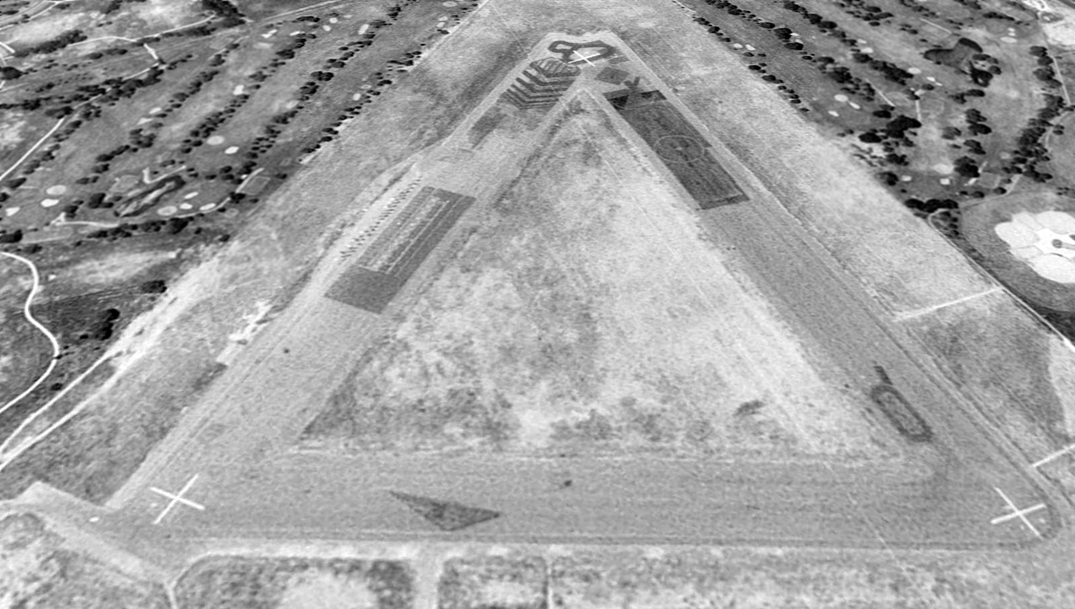
A 1964 aerial view of Mile Square, from the Anaheim Library (courtesy of Scott O'Donnell).
The airfield at Mile Square consisted of 3 paved runways:
two 2,500' runways connected by a 2,000' strip, forming a triangle.
Note the complete lack of development around the airfield - it is surrounded by nothing but farmland!
The August 1965 San Diego Sectional Chart (courtesy of Ron Kunse) depicted “MCOLF Mile Square”
as having 3 paved runways, with the longest being 2,500'.
Mile Square was still depicted as an active military airfield on the 1966 San Diego Sectional Chart (courtesy of Chris Kennedy).
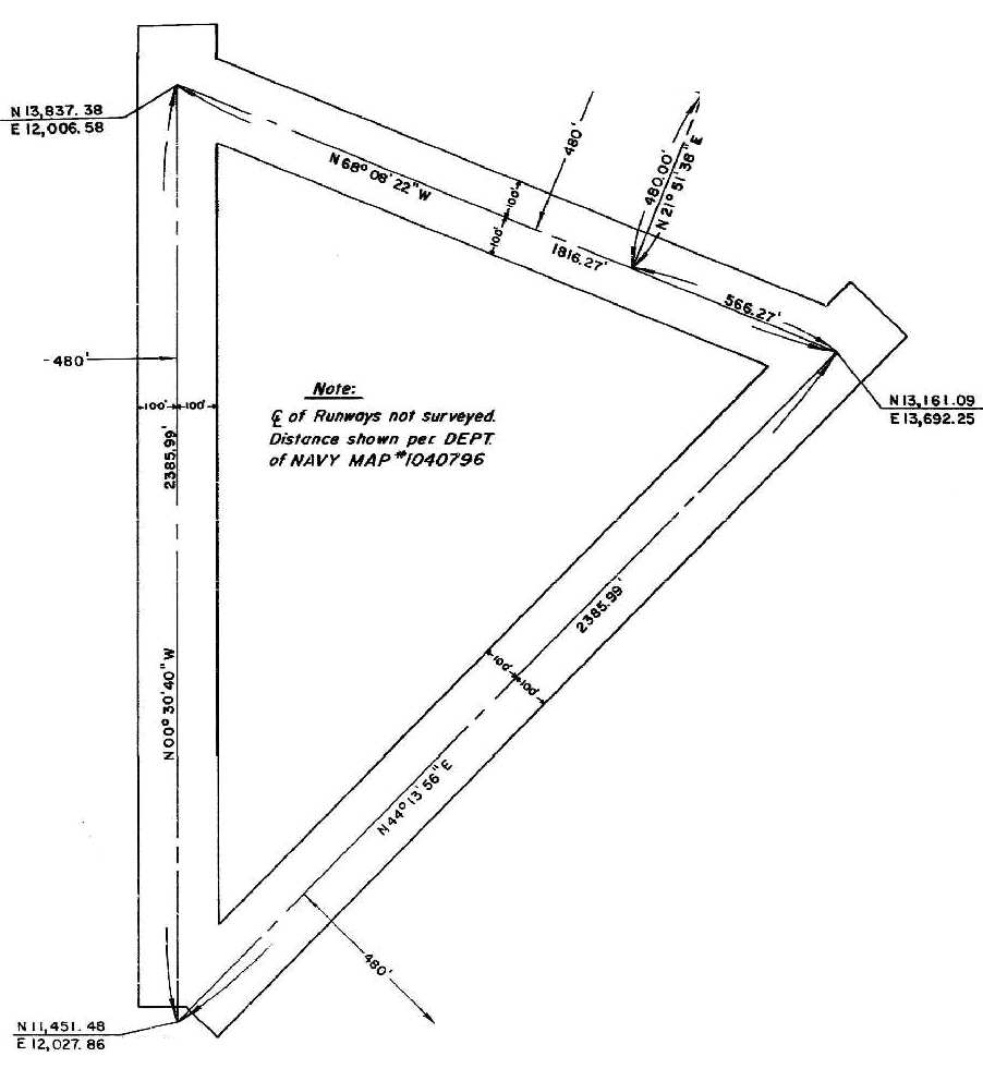
A 1967 Orange County Road Department Survey Map of the runways at Mile Square (courtesy of Scott O'Donnell).
In 1967, the Navy leased portions of the facility to Orange County
In March of 1967, Orange County entered into a long term lease with the Navy Department for the perimeter acreage of the site.
That lease allowed the county to develop this acreage for regional park purposes,
and until the county could afford to develop all the acreage,
the county was permitted to continue the agricultural lease.
In 1970, the first 85 acre phase of Mile Square Regional Park was opened.
Phase II which added ball diamonds & a children's play area was constructed & opened in 1973.
The Phase III development, extending the park northward to Edinger Avenue was constructed & opened at the end of 1976.
A 1972 aerial view showed the 3 asphalt runways were each marked with a closed “X” symbol.
On 3/28/73, after the Navy Department formally declared the perimeter acreage surplus,
the County of Orange received title to the perimeter acreage at no cost under the Federal Legacy Parks Program.
Military operations in the center airfield ceased in 1974.
In 1975 the county received an annual permit to operate the center triangle area for public recreation.
The July 1980 LA Terminal Chart (courtesy of Jim Hackman) depicted “MCOLF Mile Square” as a closed field having 3 paved runways.
The park's Phase IV development commenced in the spring of 1987.
Found within this final phase is a 18-hole executive golf course, complete with club house, driving range & banquet facility.
Additional acres of park land include picnic facilities, bicycle trails, landscaping and a second park entrance.
Mile Square's 3 paved runways still remained as seen in a 1994 USGS aerial view looking south.
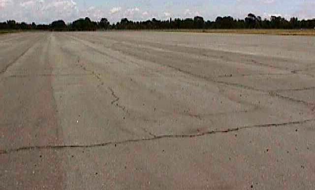
The north runway, as it was used for landsailing, before being destroyed for golf course expansion.
At one point a local organization called Save Mile Square was trying to save the park from the greed of local developers & politicians.
Mile Square's 3 paved runways were designated by the park for a while to be used for landsailing & radio controlled model aircraft,
but were torn up by 2000 to make room for expansion of the surrounding golf course
(because we certainly don't have enough golf courses!).
John Smith reported in 2004 that "all remnants of the airfield are completely gone."
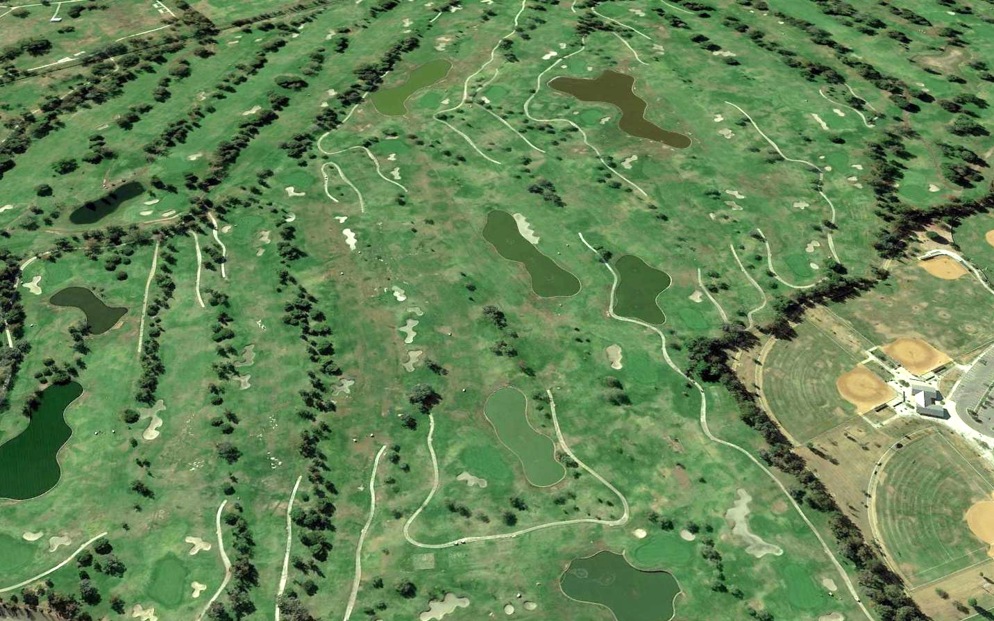
A 2016 aerial view looking south showed that all of Mile Square's runway pavement had been removed, with no trace remaining of the former military airfield.
Thanks to Robin Dee for information about Mile Square.
See also: A 1994 Army Corps of Engineers report.
____________________________________________________
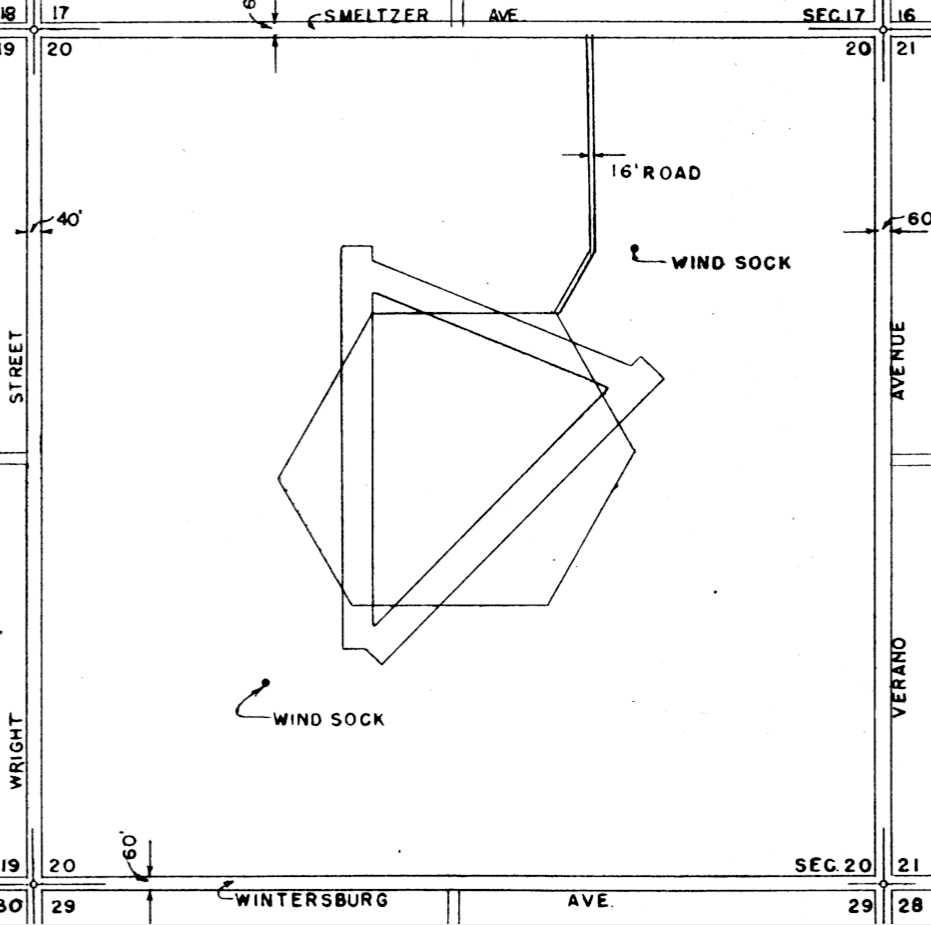
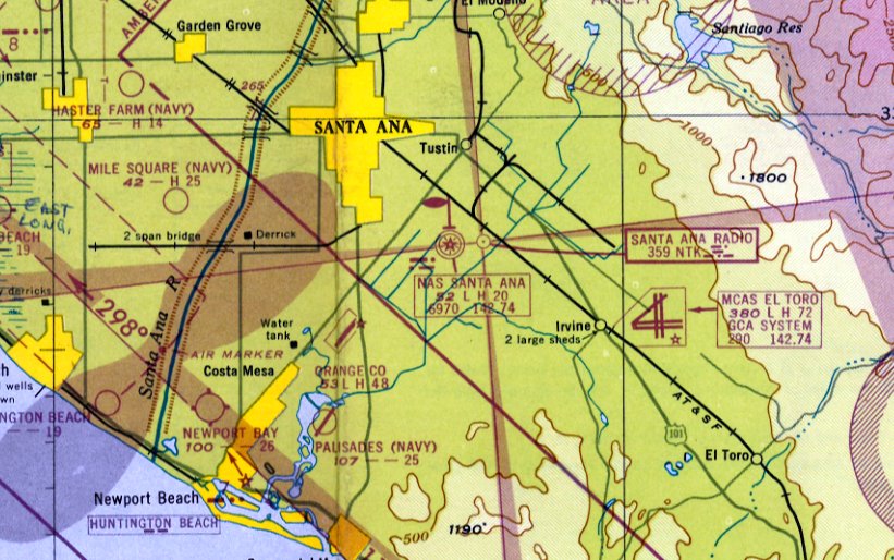
Palisades Naval Outlying Landing Field, Newport Beach, CA
33.64, -117.88 (South of John Wayne Orange County Airport, CA)
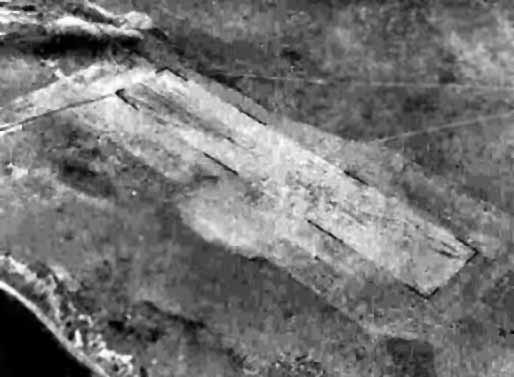
A 7/21/43 aerial view looking west at “Los Alamitos Field Auxiliary (13614 Palisades Outlying Field)”
from the 1945 AAF Airfield Directory (courtesy of Scott Murdock).
The date of construction of this WW2-era Navy satellite airfield has not been determined.
Palisades was originally one of 4 NOLFs which were closely located between Los Alamitos & El Toro:
the others were Horse Farm NOLF, Haster Farm NOLF, and Mile Square NOLF.
Mile Square was built in 1942, so Palisades was probably built around the same time.
The earliest depiction which has been located of the Palisades Airfield
was a 7/21/43 aerial view looking west at “Los Alamitos Field Auxiliary (13614 Palisades Outlying Field)”
from the 1945 AAF Airfield Directory (courtesy of Scott Murdock).
It depicted the field as a single northeast/southwest runway.
The Palisades airfield was not depicted on the on 1944 San Diego Sectional Chart (according to Chris Kennedy),
The 1945 AAF Airfield Directory (courtesy of Scott Murdock) described “Los Alamitos Field Auxiliary (13614 Palisades Outlying Field)”
as having a single 2,500' seal-coated east/west runway.
The field was said to not have any hangars.
"Palisades (Navy)", as depicted on the August 1945 San Diego Sectional Chart (courtesy of Chris Kennedy).
According to John Voss, the runway at Palisades
"was a standard 2,500' long & quite wide... maybe a hundred yards or more.
Apparently it was used jointly by NAAS Los Alamitos (for flight training N2T's)
as well as by NAS Santa Ana [later to become Tustin MCAS]
where they used it for remote control aircraft (Curtiss SO3C Seagull)."
The 1947 USGS topo map labeled the field simply as “Palisades”.
The 1947 LA Local Aeronautical Chart depicted “Palisades (Navy)” as having a 2,500' northeast/southwest paved runway.
Palisades apparently saw some reuse by the Navy starting in 1947.
John Voss reported, “Victor Smith was assigned to the base [NAS Santa Ana] in 1947.
He commented that VU-7(a) was based at NAS Santa Ana for the continuation of pilotless aircraft evaluation.
VU-7(a) utilized Culver TD2C / Grumman F6F Hellcats as drone aircraft
with Beech SNB Expeditors as the drone controllers.
OLF Palisades was used for the flight operations (launch & recovery)
and that the small quonset building was the 'mess area' when they were doing field operations there.
The operations at Palisades were Target Drone Operations.
The unmanned drones were launched & flown out to a target area for ship-to-air target practice.
If they survived they were brought back to Palisades; from there, back to home base.
The squadron was relocated to MCAS El Toro in 1948.”
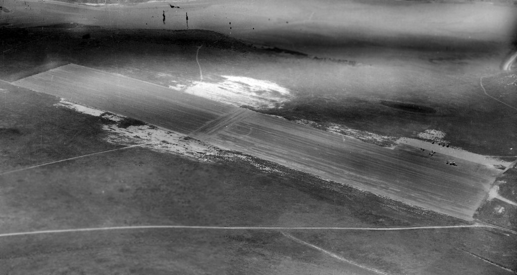
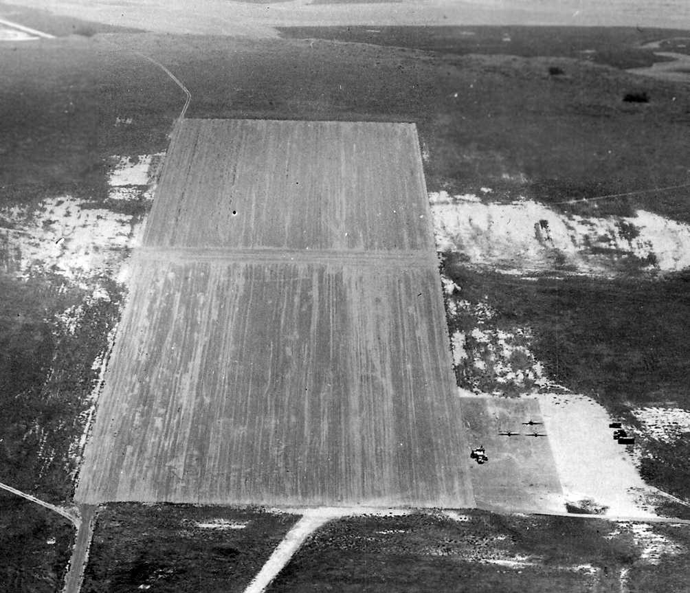
A May 1948 U.S Navy aerial view looking west at Palisades OLF (courtesy of Brian Rehwinkel).
Brian observed, “You can see the lines of cliffs (palisades) that gave the field its name.
You can also see 3 planes in a parking area – along with several vehicles. The planes could be drones, but I am not sure.”
A May 1948 U.S Navy aerial view looking southwest along the Palisades runway (courtesy of Brian Rehwinkel),
showing 3 unidentified aircraft on the ramp.
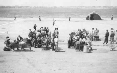
A 1949 photo of VU-3 squadron members at their annual Beer & Bar-B-Que Party at Palisades NOLF (courtesy of Victor Smith, via John Voss).
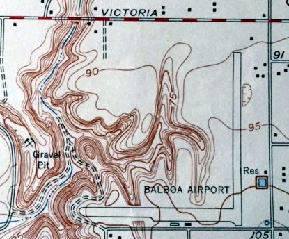
The 1951 USGS topo map (courtesy of Kevin Walsh) depicted Palisades as having a single northeast/southwest runway,
but it was labeled merely "Landing Field".
"Palisades (Navy)" was depicted on the March 1951 San Diego USAF Sectional Chart (according to Chris Kennedy),
but the Aerodromes table described the field as "Closed".
The March 1952 San Diego Sectional Chart depicted “Palisades (Navy)” as having a 2,500' paved runway.
A 1952 aerial view depicted the Palisades field as having a single paved northeast/southwest runway.
"Palisades OLF" was still depicted on the September 1955 San Diego Sectional Aeronautical Chart (courtesy of Chris Kennedy).
The Aerodromes table described Palisades as having a single 2,500' bituminous runway.
Palisades NOLF was apparently closed at some point between 1955-59,
as it was no longer depicted at all on the September 1959 San Diego Sectional Chart (courtesy of Chris Kennedy).
John Voss continues, "In the late 1950s some of my high school buddies & I
would take our cars to OLF Palisades & do a bit of drag racing there.
It was totally abandoned & a nice road led right to the end of the strip.
There was a small Quonset hut remaining & a wind direction vane (still working & creaking it the wind).
OLF Palisades was [eventually] converted into housing (and nice ones at that)."
Palisades was definitely closed by 1960, as it was labeled "Aband arpt" on the 1960 LA Local Aeronautical Chart.
A 1964 aerial view of the site of the Palisades airfield, from the Anaheim Library (courtesy of Scott O'Donnell).
A portion of the runway at Palisades still remained,
but housing had already been constructed along the east side of Eastbluff Drive,
and a high school track has already been constructed at the south end.
The Palisades airfield was not depicted at all on the 1965 LA Local Area aeronautical chart (courtesy of John Voss).
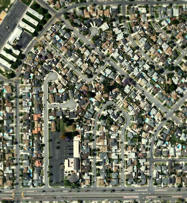
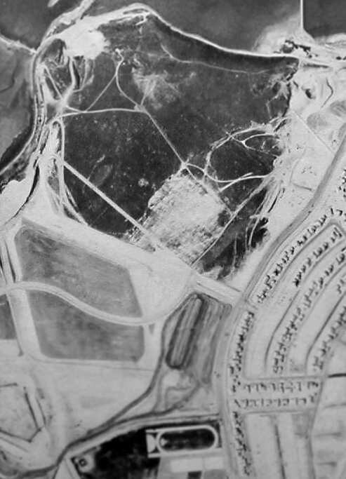
A 1972 aerial photo showed that the center of the site of Palisades NOLF had become Eastbluff Park,
with the surrounding area all having been filled in with dense housing.
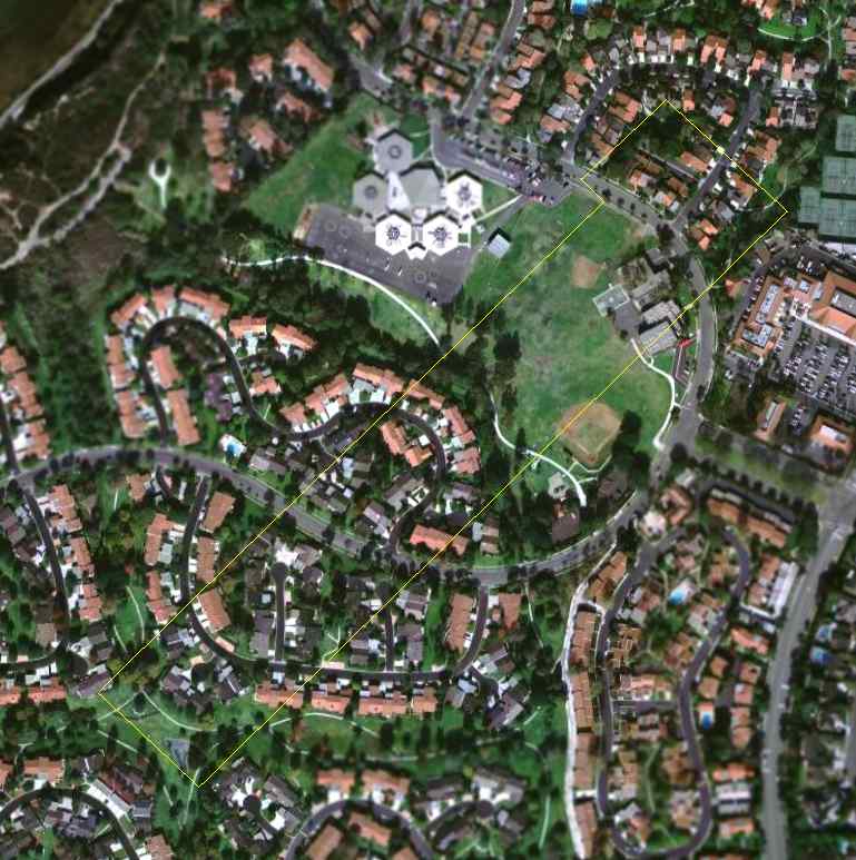
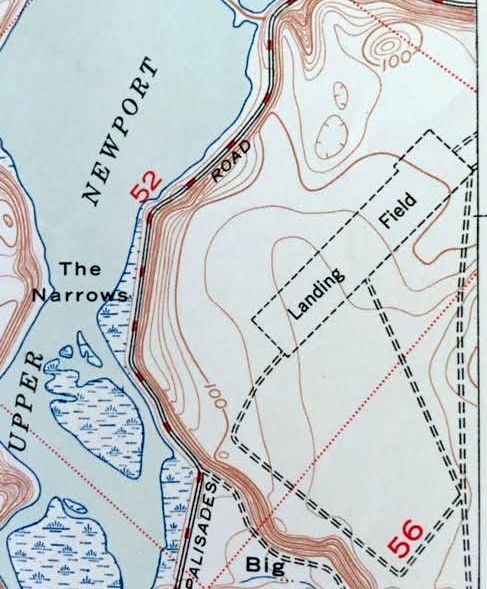
A 2006 aerial photo, annotated by Chris Kennedy to show the location of the former runway of the Palisades airfield.
The site of Palisades NOLF is located just west of the intersection of Eastbluff Drive & Vista Del Oro.
____________________________________________________
____________________________________________________
This site covers airfields in all 50 states.