
Abandoned & Little-Known Airfields:
California: Northern Palmdale area
© 2002, © 2026 by Paul Freeman. Revised 7/1/26.
This site covers airfields in all 50 states: Click here for the site's main menu.
____________________________________________________
Please consider a financial contribution to support the continued growth & operation of this site.
For a 10th year, the CA pages of this website are sponsored by the California Pilots Association:
Antelope Valley Intermediate Field Site 5 / Site 5B (revised 11/28/23) - Helendale Aux AAF #2 / Helendale Airport (revised 1//8/25) - (Original) Lancaster Airport (revised 1/12/19)
Liberty Field (revised 3/16/23) - Riley Airport (revised 1//8/25) - Sky Castle Airport (revised 1/12/19) - Sterk's Ranch Airfield (added 1/8/25)
War Eagle Field / Lancaster Airpark (revised 7/11/26) - Victory Field (revised 11/27/21)
____________________________________________________
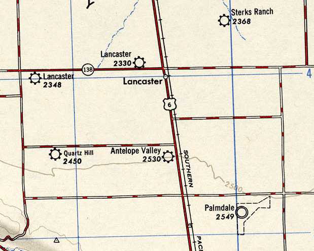
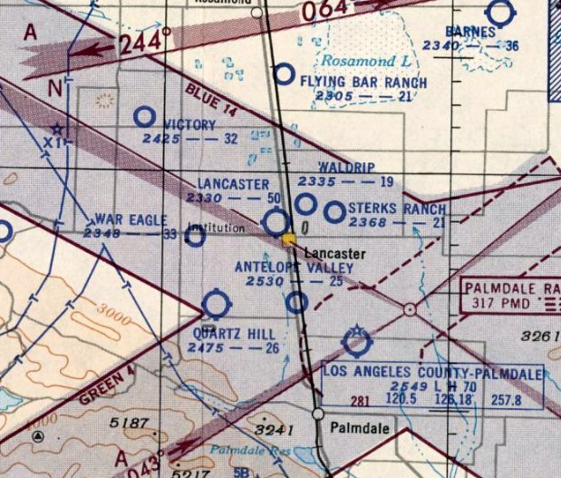
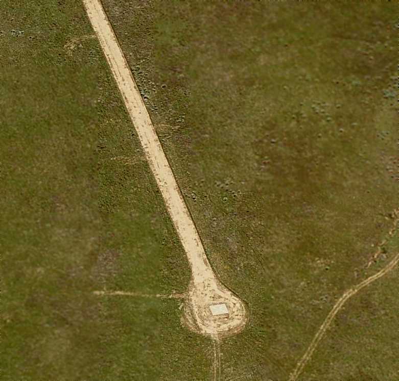
Sterk's Ranch Airfield, Lancaster, CA
34.714, -118.098 (North of Palmdale, CA)

Sterk's Ranch Airfield, as depicted on the February 1947 LA Sectional Chart.
According to Peter Sterk's obituary, “Sterk was owner of Sterk's Ranch Airfield on Lancaster east side.
In the early 1940s Sterk entered the aviation field. He became an aircraft painter/mechanic at War Eagle Field.
The pilots at War Eagle Field needed additional airstrips for touch-and-go landings, so Sterk offered use of his extra land.”
Steve Sterk recalled, “My grandfather homesteaded the 160 acres for $1/acre, just east of War Eagle Field.
The airport was operational from 1944-77.”
Sterk's Ranch Airfield was not yet depicted on the 1946 LA Sectional Chart.
The earliest depiction which has been located of Sterk's Ranch Airfield was on the February 1947 LA Sectional Chart,
which depicted it as a commercial/municipal airport.
According to Peter Sterk's obituary, “In 1947, Sterk bought a surplus open-cockpit, low-wing primary trainer PT-19 airplane in Reno for $1,700.”
“I had a plane, and I wanted to learn to fly it”, he said.
He took lesson & received his pilot's license. A few years later, he bought a damaged PT-26 with an enclosed canopy & 200 horsepower engine, which he installed in his PT-19.
The earliest topo map depiction which has been located of Sterk's Ranch Airfield was on the 1947 USGS topo map.

The earliest photo which has been located of Sterk's Ranch Airfield was an 11/20/48 USGS aerial view.
It depicted 2 dirt runways, with 4 light single-engine planes parked on the southeast side.

A circa 1940s photo of Pete Sterk on his Fairchild PT-19 at Sterk's Ranch Airfield (courtesy of Steve Sterk).

A circa 1940s drawing (courtesy of Steve Sterk) showed 2 hangars among the buildings of the Sterk Ranch.
The March 1952 LA Sectional Chart depicted Sterk's Ranch Airfield as having a 2,100' unpaved runway.

The last photo which has been located showing aircraft at Sterk's Ranch Airfield was a 7/28/56 USGS aerial view.
It depicted 2 dirt runways, with 7 light single-engine planes parked on the southeast side.

The 1957 LA Sectional Chart depicted Sterk's Ranch Airfield as having a 2,100' unpaved runway.

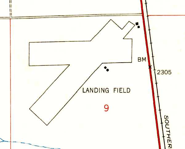
The 1959 USGS topo map depicted Sterk's Ranch Airfield as 2 runways, generically labeled “Landing Field”.

The 1969 LA Sectional Chart depicted Sterk's Ranch Airfield as having a 2,100' unpaved runway.

The 1975 USGS topo map depicted Sterk's Ranch Airfield as 2 runways (wth the northeast/southwest runway replacing the previous east/west strip), generically labeled “Landing Field”.
According to Steve Sterk, “The airport was operational [to] 1977.”

The last aeronautical chart depiction which has been located of Sterk's Ranch Airfield was on the 1986 LA Sectional Chart, which depicted it as having a 2,100' unpaved runway.
Sterk's Ranch Airfield was evidently closed (for reasons unknown) at some point between 1986-94,
as it was no longer depicted on the 1994 LA Sectional Chart.
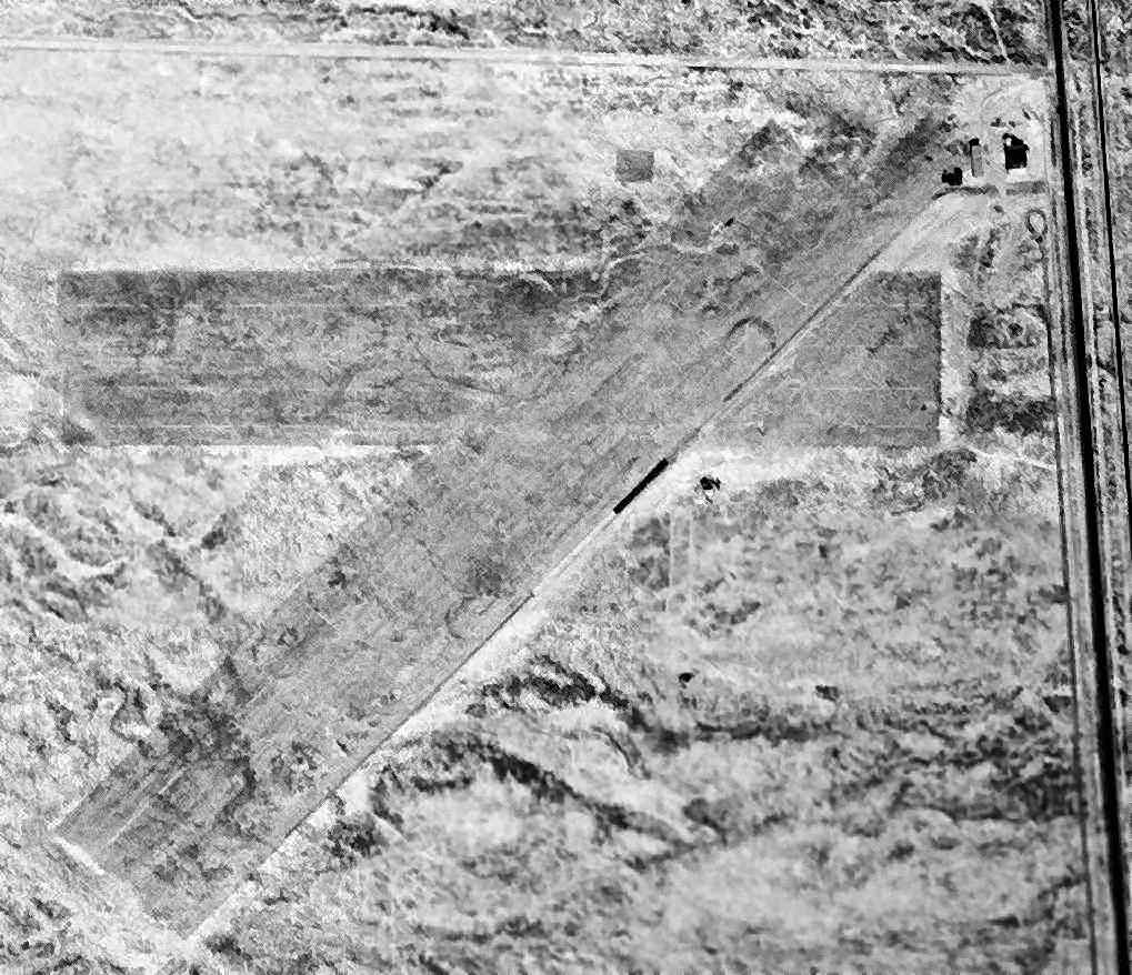
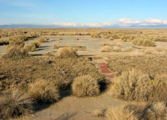
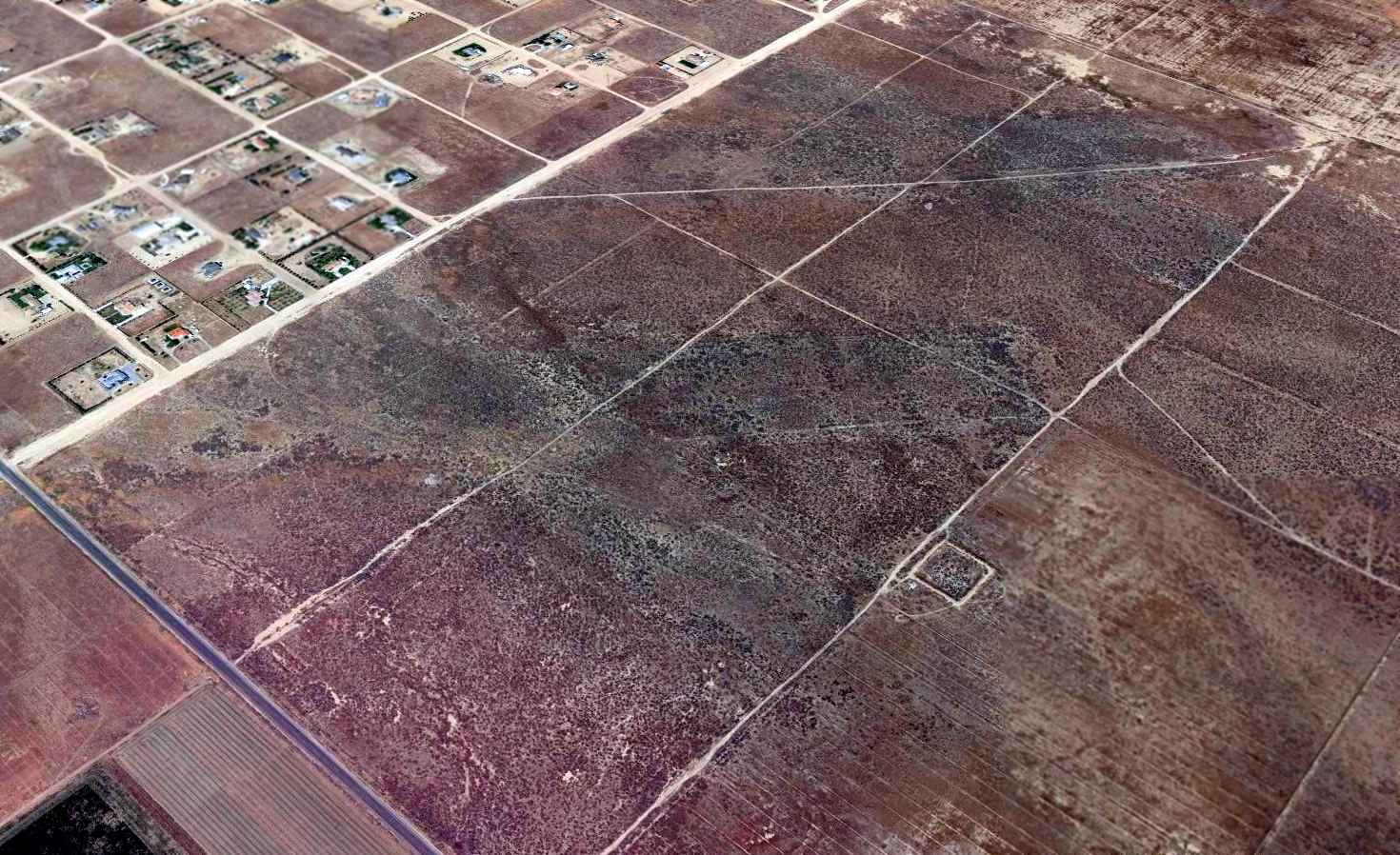
A 2006 aerial photo still showed the remains of the 2 Sterk's Ranch Airfield runways.
A 2008 photo showed the remains of the 2 Sterk's Ranch Airfield runways had been almost completely removed at some point between 2006-2008, covered by new residential construction.

A 2024 aerial photo showed a new housing development covering nearly all the Sterk's Ranch Airfield site, but a faint trace of the northeast end of a runway remained intact, just north of the development.
Thanks to Steve Sterk for pointing out this airfield.
____________________________________________________
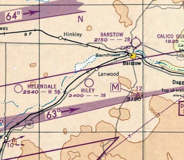
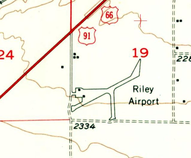
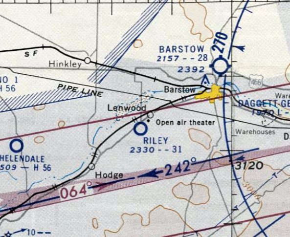
34.853, -117.131 (Northwest of Palmdale, CA)
Riley Airport, as depicted on the February 1949 LA Sectional Chart.
This desert general aviation airport was evidently established at some point between 1948-49,
as it was not yet depicted on the 1948 LA Sectional Chart.
The earliest depiction which has been located of Riley Airport was on the February 1949 LA Sectional Chart,
which depicted Riley as having a 2,800' unpaved runway.

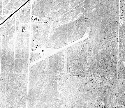
The earliest photo which has been located of Riley Airport was a 6/1/52 USGS aerial view,
which depicted Riley as having an unpaved northeast/southwest runways, several taxiways / parking areas, and a few small buildings on the west side.
The earliest topo map depiction which has been located of Riley Airport was on the 1956 USGS topo map (courtesy of Mike Kenton),
which depicted Riley as having 2 runways & a ramp & 2 small buildings on the west side.
The last aeronautical chart depiction which has been located of Riley Airport was on the September 1957 LA Sectional Chart,
which depicted Riley as having a 3,100' unpaved runway.
A 1959 aerial view (courtesy of Mike Kenton) depicted Riley Airport as having an unpaved northeast/southwest runways, several taxiways / parking areas, and a few small buildings on the west side.
A 1970 aerial view showed no sign remaining of the Riley Airport runways, with several residential streets having been paved over the site,
but a former airport building remained standing on the west side.
A 1984 aerial view showed several houses having been built over the Riley Airport site,
but a former airport building remained standing on the west side.
A 1995 aerial view showed former the airport building had been removed on the west side, erasing the last trace of Riley Airport.

A July 2012 photo looking west showed no trace remaining of Riley Airport.
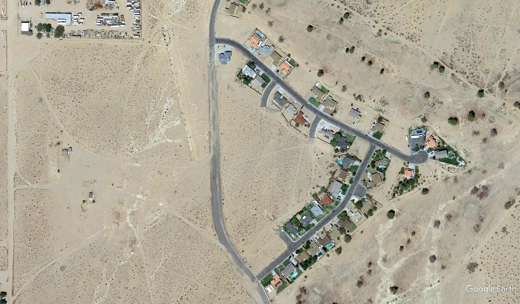
A 2014 aerial photo showed no trace remaining of Riley Airport.
Thanks to Mike Kenton for pointing out this airifeld.
____________________________________________________
War Eagle Field / Lancaster Airpark, Lancaster, CA
34.7, -118.23 (Northwest of Palmdale, CA)
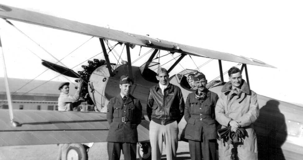
A 1941-42 photo of Wilfred Munsch & other cadets & instructors in front of a Stearman at War Eagle Field
(courtesy of Rick Munsch, whose father Wilfred was an RAF cadet at War Eagle).
War Eagle Field in Lancaster is not to be confused
with another airfield by the same name in Dos Palos, 175 miles to the northwest.
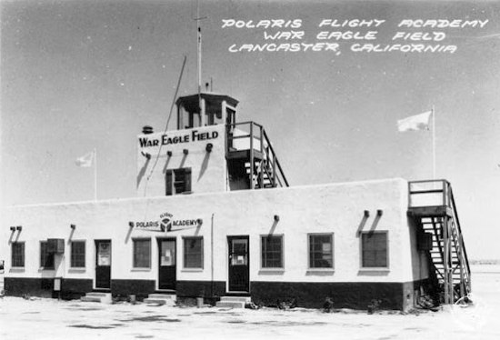
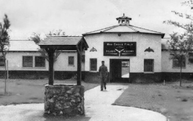
War Eagle Field was the site of a contract flying school, Polaris Flight Academy,
which was one of 4 schools operated by the Cal-Aero Flight Academy,
headquartered at Glendale's Grand Central Air Terminal.
The civilian schools were contracted by the US & foreign militaries to provide flight training for military cadets.
War Eagle Field opened in 1941, initially providing training to British & Canadian cadets.
Al Shaver recalled, “During 1941 & 1942 I was an instructor at War Eagle Field teaching RAF cadets.”
A 1941-42 aerial photo of Wilfred Munsch of buildings at War Eagle Field (courtesy of Rick Munsch).
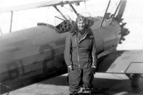
A Winter 1941 / Spring 1942 photo of British flight cadet Thomas Forbes in full flying gear in front of a Stearman PT 17 biplane trainer at War Eagle Field (courtesy of Tom Forbes).
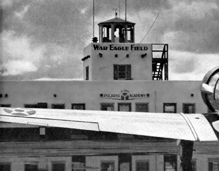
A circa 1941-45 photo of the War Eagle Field control tower (courtesy of Paul Webber, via Tom Forbes).
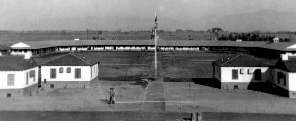
A January 1942 aerial view looking south at War Eagle Field
(courtesy of Jeremy Davies, whose father attended training at the Polaris Flight Academy with the RAF).
In 1942, following the United States' entry into the war, it also began the training of USAAF cadets.
The War Eagle Flight Academy became at the time the only civilian school in the US to handle basic training of Army pilots.
Upon accepting the new role, construction commenced to double the size of the base.
The airfield at War Eagle Field was centered around 2 large hangars at the northwest end of the site.
A 2,400' long ramp just south of the hangars was oriented northeast/southwest,
and the two 2,400' runways extended to the east & south away from the ramp.
An undated view of the tower at War Eagle Field (courtesy of Dan MacPherson).
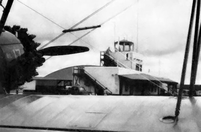
A 1942 view of the control tower through the wings of a Stearman trainer (courtesy of Dan MacPherson).
Every 4 & one-half weeks a new group of US pilots would arrive at Lancaster to commence their basic training.
After completing their course here, they were sent to Army Advance Training posts
where upon completion of their advance course they received their wings & commission.
The Vultee BT-13 was the predominant trainer aircraft used at War Eagle Field.
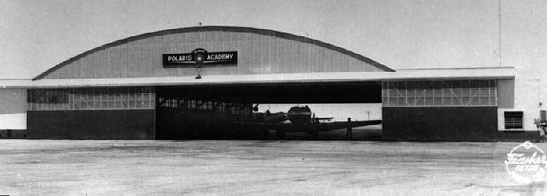
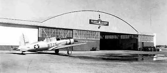
A WW2-era view of a hangar at War Eagle Field's Polaris Flight Academy.
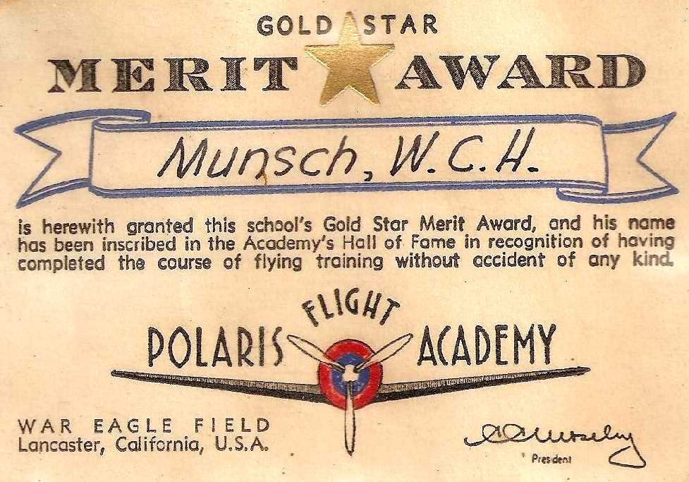
A circa 1942 “Gold Star Merit Award” presented to RAF Cadet Wilfred Munsch
for having completed flight training without an accident at War Eagle Field (courtesy of Rick Munsch).
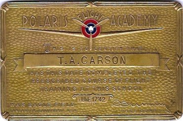
A Polaris Academy engraved metal plaque presented to T.A. Carson upon completion of his flight training on 6/17/42 (courtesy of Tom Forbes).
A circa 1942 photo of a Spartan 7W Executive sporting a Polaris logo in front of a War Eagle Field hangar (courtesy of Tom Forbes).
A WW2 era photo of a Vultee BT-13 in front of a Polaris Academy hangar at War Eagle Field.
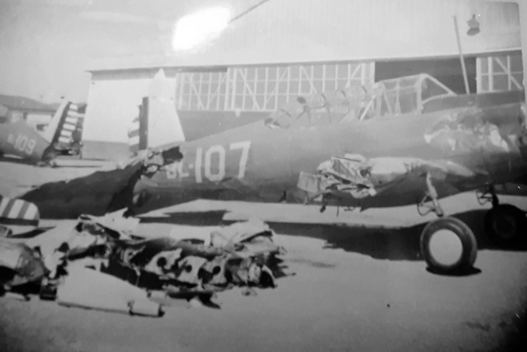
A WW2 era photo of a Vultee BT-13 (which came to much grief) in front of a War Eagle Field hangar (courtesy of John Voss).
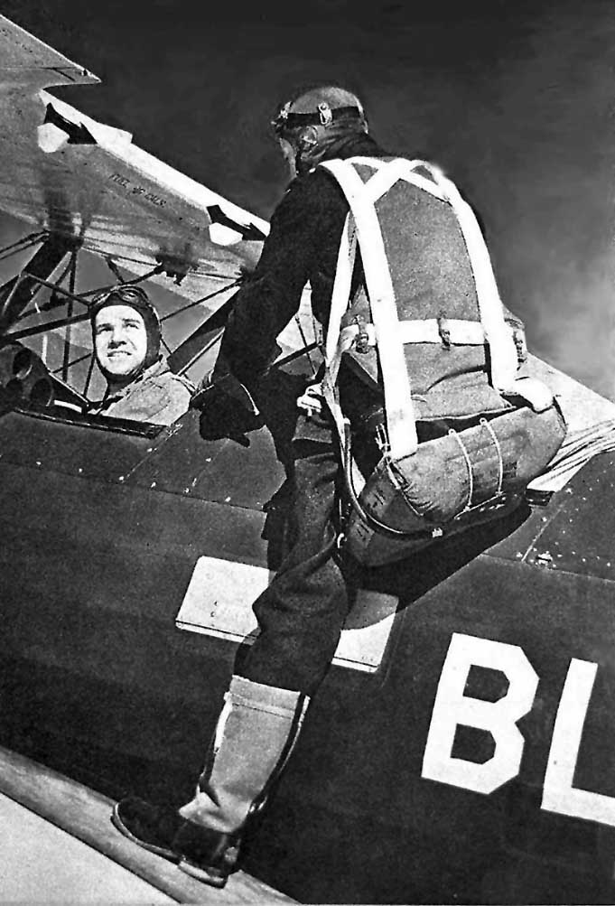
A WW2 era photo of a cadets getting into a PT-17 at War Eagle Field (courtesy of John Voss).
John Voss observed, “It’s a PT-17 used by the RAF cadets with the fuselage code letter of 'BL' signifying British Lancaster.”
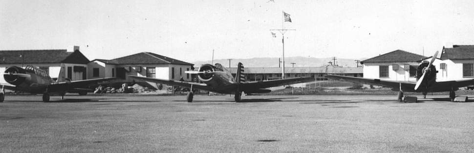
Vultee trainers on the flightline at War Eagle Field during WW2.
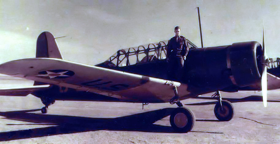
LT George Wood Mears, in front of a Vultee BT-13 at War Eagle Field during WW2.
A 1942 photo of War Eagle's Administration Building (courtesy of Dan MacPherson).
Bruce Stanton reported, “My father, Jay Stanton, was a Flight Instructor at the Polaris Flight Academy throughout most of WWII.”
A 7/22/43 aerial view looking west from the 1945 AAF Airfield Directory (courtesy of Scott Murdock)
depicted War Eagle Field as having 2 paved runways.
In 1944, the name of the Polaris Flight Academy was changed to Mira Loma Flight Academy.
The 1944 US Army/Navy Directory of Airfields (courtesy of Ken Mercer)
described "War Eagle, Army" as having a 3,100' runway.
Two smaller auxiliary landing fields were associated with War Eagle Field during WW2:
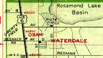
Liberty Field (located 8 miles northeast of War Eagle Field),
and Victory Field (located 6 miles northwest of War Eagle Field).
In an article in AOPA Pilot Magazine, Duane Cole described meeting famous test pilot Tony LeVier at War Eagle Field:
“I never had the opportunity to meet him until 1942, at War Eagle Field, where I was instructing military cadets.
By that time I knew he had gone to work for the Lockheed Aircraft Company,
and I'd heard of his mastery over the P-38, which started life with a tarnished reputation.
The new, unconventional twin-engine fighter had received bad press from several fatal crashes,
including the one that took the life of movie star Joe E. Brown's son.
To overcome its bad publicity, Tony had brought a P-38 to War Eagle Field
to demonstrate its capabilities to the cadets at a graduation ceremony,
and to assure them that there was nothing dangerous about the airplane when flown by well-trained pilots.
Having never seen him fly, I was completely amazed by his low-level spins;
single-engine rolls, both left & right, on first one engine then the other;
loops; Cuban eights; and all the other maneuvers the cadets had learned in their basic training.
Landing after his superb exhibition, Tony was surrounded by admirers & old friends.”
Duane continued, “Tony visited War Eagle Field on several occasions after that,
but none of them was more sensational than the visit he made in 1944.
I was in the office of Hank Reynolds, civilian director of the field, discussing my new job as the school's test pilot,
when suddenly, going faster than anything we had ever seen, an airplane made a low-level pass down the runway.
By the time we had burst through the door, the airplane had climbed to about 3,000 feet.
From there the pilot peeled off & buzzed the field in the other direction.
It was Tony in the new Lockheed XP-80 jet, the first time anyone on the field had ever seen it.
When I got home that evening, my wife, Judy, and her mother, who was visiting from Illinois,
began excitedly telling me about the super-fast airplane that had passed over our house.
We lived on Quartz Hill, only 3 or 4 miles from the field.
Judy's mother called it a 'zip'. When I asked her why, she said, 'We saw it coming & then zip, it was gone.'”
The 1945 AAF Airfield Directory (courtesy of Scott Murdock) described War Eagle Field
as a 640 acre square-shaped property having 2 bituminous runways, measuring 3,100' northeast/southwest & 2,950' east/west.
The field was said to have a total of 3 wood & metal hangars, the largest being a pair of 200' x 100' structures.
War Eagle Field was said to be owned by the Defense Plant Corporation, and operated by private interests.
It was said to have 2 auxiliary fields: #1 Liberty Field, and #2 Victory Field.
The Mira Loma Flight Academy at War Eagle Field was closed in 1945 with the end of World War II,
but the airfield itself at War Eagle Field apparently remained in operation for a few more years.
War Eagle Field was still depicted as an active auxiliary airfield
on the February 1947 LA Sectional Chart (courtesy of Chris Kennedy).
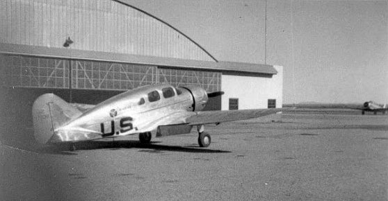
An 11/20/48 USGS aerial view showed a C-47 & 3 smaller single-engine aircraft on the ramp at War Eagle Field.
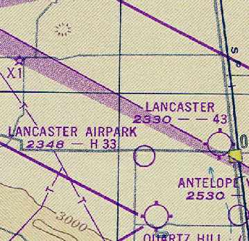
At some point between 1947-49, War Eagle Field was evidently renamed Lancaster Airpark,
as that is how it was labeled on the February 1949 LA Sectional Chart (courtesy of Chris Kennedy).
It was depicted as having a 3,300' hard surface runway.
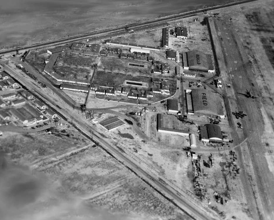
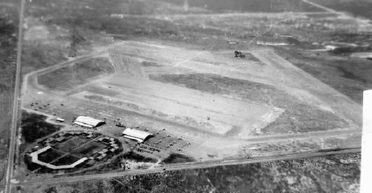
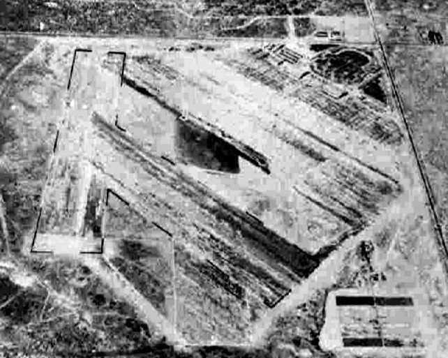
A circa early 1950s aerial view looking southeast at War Eagle Field (courtesy of Jim Walker).
Note that the facility had already began to be converted for use as a prison (or was already in use as such),
as there were about a half dozen guard towers around the perimeter, with one in the center.
However, it was apparently still in use as an airfield, as there is a C-47 on the ramp at the right,
and one single-engine trainer in between the 2 large hangars.
Also note that the 1st two letters of the airfield name on the roof of the hangars had been painted out,
changing it from "War Eagle Field" to "Reagle Field" - ???
The 1951 USGS topo map depicted the hangars & buildings of “War Eagle Airfield”,
but did not depict any runways or other airfield area.
A 4/9/53 aerial view of War Eagle Field (from the UCSB Library)
showed the buildings already in use as a prison,
but the airfield was evidently still also in use, as there appeared to still be one aircraft on the ramp.
The lettering on the hangar roofs continued to spell "Reagle Field".
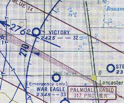
The 1953 Flight Chart (courtesy of Scott O'Donnell)
once again labeled the field as "War Eagle", but it was described as "Emergency only".
It was described as having a 3,300' runway.
The buildings at War Eagle apparently sat idle until 1954,
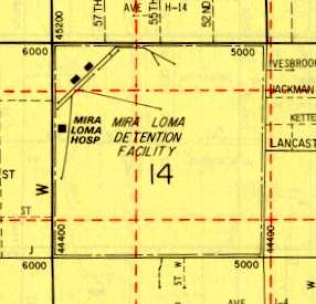
when the LA County Sheriff's Department & Department of Hospitals
opened the Mira Loma Custody Facility at the site, for inmates with tuberculosis.
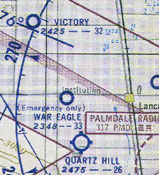
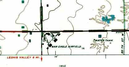
The September 1954 LA Sectional Chart (courtesy of Chris Kennedy)
continued to depict War Eagle Field as available for "Emergency only".
The "Institution" was already depicted,
but apparently the airfield continued to coexist (at least for a short period of time) with the custody facility.
The airfield at War Eagle Field was evidently closed by 1964,
as it was no longer depicted at all on the 1964 LA Sectional Chart (courtesy of John Voss).
A 1974 aerial view did not show any signs of aviation use of the property.
Some of the original layout of the airfield at War Eagle Field
was still apparent as depicted on a 1978 map (courtesy of Dan MacPherson).
The tuberculosis facility at the former War Eagle Field closed in 1979.
In 1983, the facility re-opened due to jail overcrowding & expanded in 1986 to include female inmates.
The Mira Loma Custody Facility closed in 1993 due to County budget cuts.
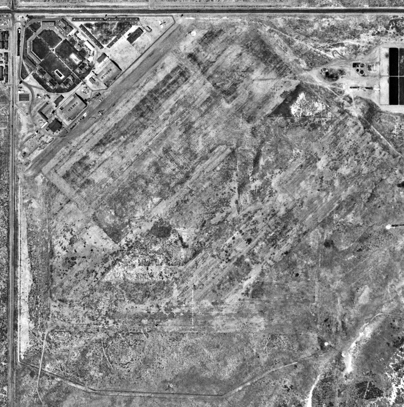
Ironically, this former WW2-era airfield gained another active aviation use at some point prior to 1994,
even after being converted largely to a prison -
a single helipad (fenced-in) was depicted on the northeast corner in the 1994 USGS aerial photo.
The Mira Loma Custody Facility was re-opened in 1997,
to house INS detainees awaiting deportation hearings.

A 1997 aerial view by Dan MacPherson looking north at the WW2-era buildings at Mira Loma.
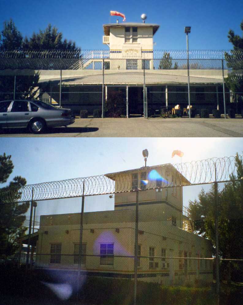
Two circa 1997 photos by Dan MacPherson of the former control tower of War Eagle Field,
now behind the fence of the Mira Loma Detention Center.
A circa 1997 photo by Dan MacPherson of the former Base Administration Building.
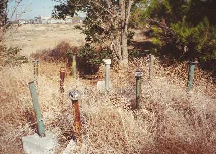
A circa 1997 photo by Dan MacPherson of the apparent remains of runway lighting, hidden in some brush near the airport.
They are triangular concrete bases with a fixture (electrical) that looks like it held a light bulb.
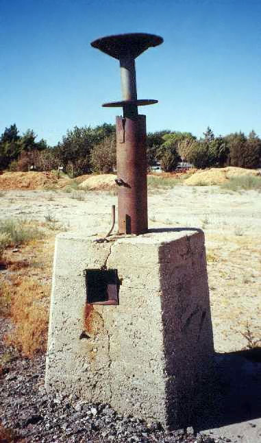
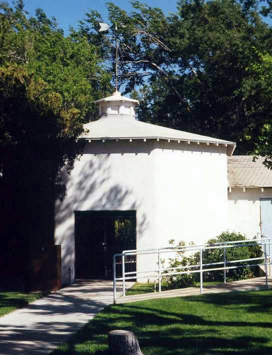
A circa 1997 photo by Dan MacPherson of the remains of the wind tetrahedron mount.
Not visible in the photo is the huge circle of rocks around this thing, still painted white after 60 years.
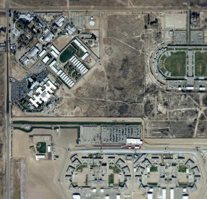
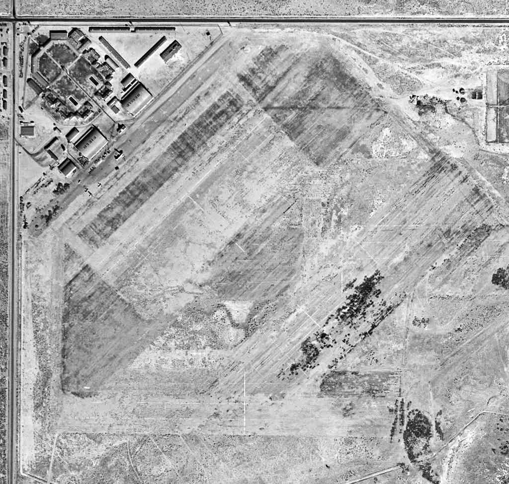
A circa 2001 aerial photo of the site. The WW2-era airfield buildings are in the northwest corner.
As of 2002, the former War Eagle Field was known as the Mira Loma Detention Center.
Two still intact hangars are still in use, as well as other WW2-era buildings.
On the roof of one of the hangars, the name "War Eagle" is still faintly perceptible.
Tim Tyler visited the site of War Eagle Field in 2003,
and he reported that it is "Now a series of detention facilities -
Challenger Memorial Youth Center on north side center,
with LA County Animal Care & Control shelter in front of it.
LA County’s Mira Loma Detention Center is on the northwest side,
and California State Prison LA County is on the entire south side.
Several old hangars & warehouse type buildings are now on the northwest section of the field,
some used by the Mira Loma Detention Center,
and some other potential War Eagle Field-era buildings are occupied by the 'High Desert Hospital'.
which is a former 170 bed hospital, now just an outpatient clinic, for ‘indigent’ people,
the North County Center for Vulnerable Families,
and Antelope Valley Service Planning Area 1 Public Health Administrative Office for LA County Health Services."
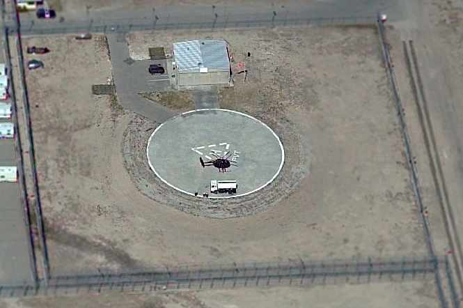
A circa 2005 aerial photo looking north at the helipad on the northeast corner of the Mira Loma facility,
with a single small hangar, and a single MD-500 helicopter on the pad.

A May 2019 photo looking northeast at the WW2 hangars which remain at the War Eagle Field site.

A July 2019 photo looking southwest at the helipad & hangar on the northeast corner of the War Eagle Field site.

A 2022 3-D aerial image looking north at the WW2 hangars & control tower which remain at the War Eagle Field site.
The site of War Eagle Field is located southeast of the intersection of West Avenue I & 60th Street West.
The property is labeled "High Desert Hospital" on recent road maps.
See also: http://www.av.qnet.com/~carcomm/wreck19.htm
____________________________________________________
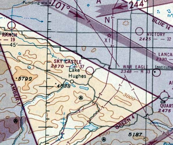
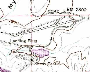
Sky Castle Airport, Del Sur, CA
34.701, -118.394 (West of Palmdale, CA)
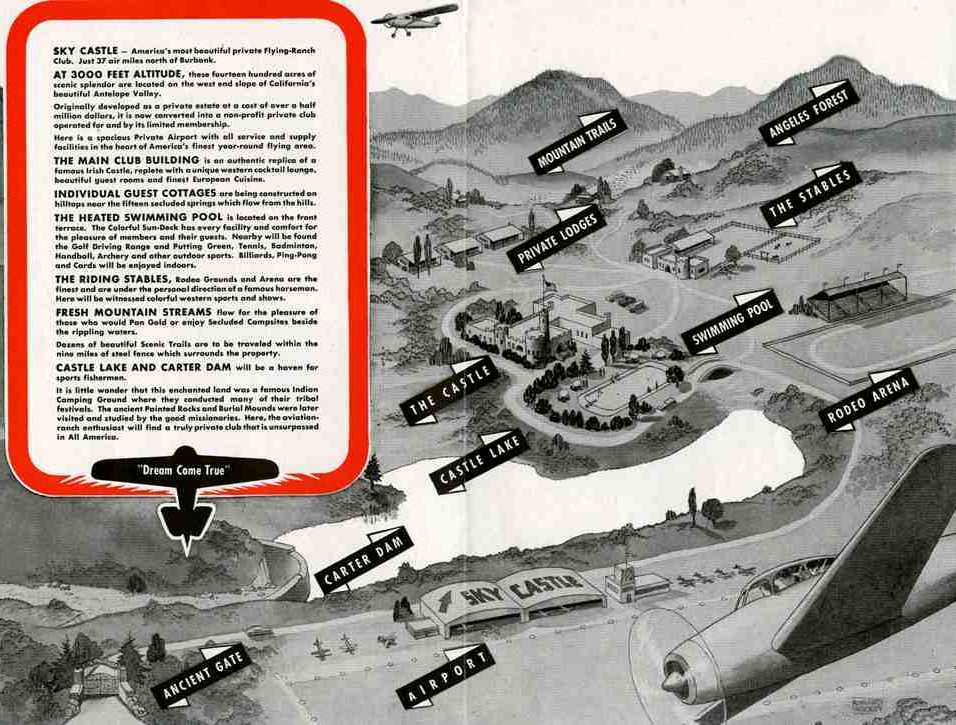
A circa 1940s brochure for Sky Castle (courtesy of Tom Pinard),
depicted the airport along with many features which were never built, including 2 hangars & administration building, rodeo arena, swimming pool, stables, etc.
Much of the following information was contributed by Jon Karkow.
What seems like a mysterious mirage in Los Angeles' backyard,
on the beautiful rolling hills near Del Sur, is a stone replica of a medieval Irish castle.
It is one of Southern California's most overlooked landmarks,
home to such characters as a cowboy star, the builder of Hancock Park & a playboy radio-TV heir.
Secluded on a tranquil hilltop, in the vast openness of the smog free high desert,
Antelope Valley's most curious architectural secret is a single-turreted granite palace fortified in mystery, and fantasy,
its story often known only through a web of rumors.
The surrounding land is still untouched as it was when a Los Angeles real estate baron decided to build this storybook fortress in 1924.
It would become known as Shea's Castle, after its builder, Richard Peter Shea.
In the early 1920s, New York-born Shea was drawn to California & Lancaster
by the area's isolation & hopes that the clear, dry air would improve the health of his wife, Ellen.
Flush with cash after subdividing Hancock Park & other wealthy Los Angeles enclaves
that sold $56 million worth of property within 3 years,
Shea reportedly spent $500,000 on his 8-bedroom, 7-bath, 7-fireplace, 2-kitchen castle.
It was a boost to the local economy.
Shea hired more than 100 laborers to quarry thousands of tons of granite from boulders on the property
to form the castle's 3- to 5-foot-thick walls. A stable in a similar motif was built just a short distance away from the castle.
Not long after the work of 2 years was done, the couple moved in.
But the 1929 stock market crash sent Shea's finances plummeting, forcing the couple to abandon the castle & move back to LA.
Shea borrowed heavily against his castle, and it was taken over by the bank.
The bank was the castle's second owner. A succession of at least 15 owners & renters over 5 decades followed.
Each left some mark on the castle.
No airfield at this location was yet depicted in the 1941 USGS topo map nor on the 1945 AAF Airfield Directory (courtesy of Scott Murdock).
In the 1940s, the property was purchased by a nonprofit flying club & named “The Sky Castle”.
A 3,000' dirt runway, a stone dam, and the lake were built
to accommodate the flying enthusiasts who flew in for a few hours or the weekend.
Flying Magazine featured a March 1948 article about the property.
The flying club was said to have nearly 300 members, and its business manager was George Carter.
As many as 50 planes were said to be common on the field for Sunday morning breakfasts.
The airfield was described as a 3,200' “sod” runway.
The most celebrated tenant of the property was Roy Rogers, the singing cowboy star of movies & TV,
who leased the site for a time & trained his famed horse, Trigger.
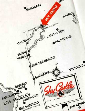
The location of Sky Castle, from a circa 1940s brochure (courtesy of Tom Pinard).
Tom Pinard recalled, “Sky Castle... our father, along with help from us boys, developed the runways & fly-in operation in the 1940s.
Cliff Pinard, owner of Hawthorne Aircraft Industries, the 'Stearman Shop',
was involved with the project, unfortunately short-lived.
We had one of our Stearmans out there to promote project
and as a lad, I recall flying over the Antelope Valley.... Lots of memories.”
Tom confirmed that Sky Castle had “no hangars... there was just a small pre-fabricated 'welcome office' at the strip.
While there were a few weekends of fly-ins, I don't remember any major Hollywood types
with the exception of Edgar Bergen flying in with 'Charlie McCarthy'.
The airport log book is missing but I remember his autograph in it.”
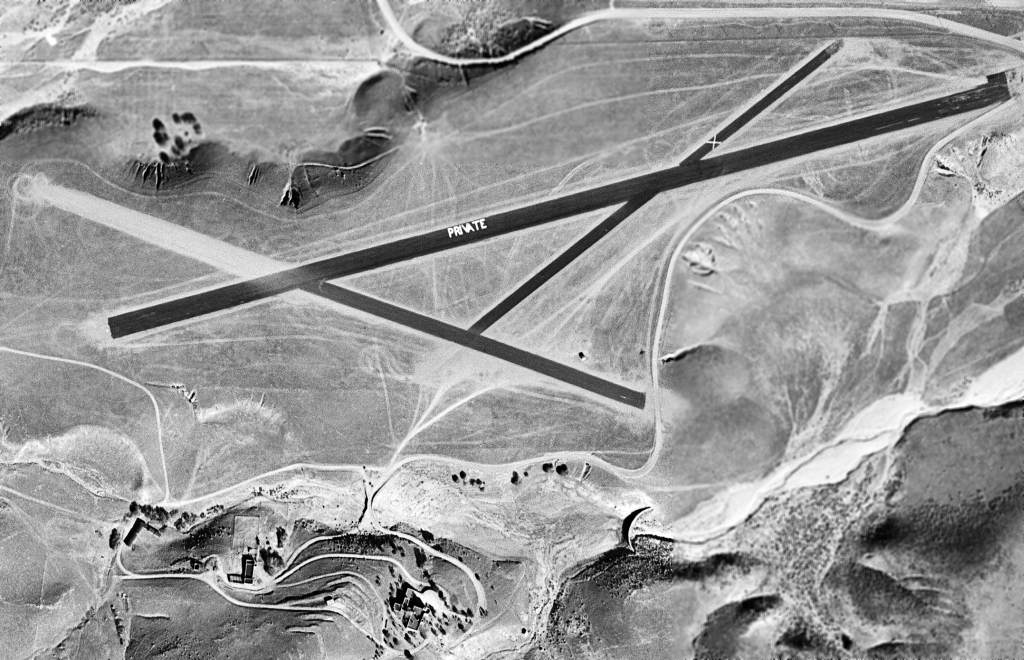
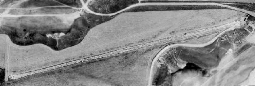
The earliest photo which has been located of Sky Castle was an 11/20/48 USGS aerial view.
It depicted the field as having 3 newly-paved asphalt runways, with the primary runway prominently marked “PRIVATE”.
The castle was visible to the south of the runway, but no aircraft were visible on the field.
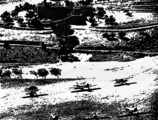
An undated photo from a 1948 magazine article showed 6 planes at Sky Castle parked in front of Shea's Castle (courtesy of Jon Karkow).
Its most notorious owner was millionaire playboy Tommy Stewart Lee.
In 1948, when his father's estate finally emerged from years of litigation,
Lee went on a spending spree, buying more cars, airplanes - and the castle.
With Lee in residence, the castle soon became a favored hangout for fast-driving, hard-living friends.
They landed their planes on the private airstrip that Lee upgraded.
He converted the stable into a garage for his race cars,
and a midget-car racetrack soon wove its way through the rolling hills behind the castle.
But within a few months of his buying the place,
Lee's relatives & business partners had him declared mentally incompetent.
In 1950, castle owner Tommy Lee jumped to his death from a fire escape at the top of a 12-story building.
The Sky Castle airfield was not depicted at all on the March 1951 LA Sectional Chart,
nor on earlier charts.
The earliest aeronautical chart depiction which has been located of the Sky Castle airfield was on the September 1951 LA Sectional Chart.
It described “Sky Castle Field” as having a 3,700' unpaved runway.
The September 1954 LA Sectional Chart (courtesy of Chris Kennedy)
described “Sky Castle Field” as having 3 runways, with the longest being a 3,650' "Natural oiled” runway.
A 1954 aerial photo depicted Sky Castle as having 3 unpaved runways.
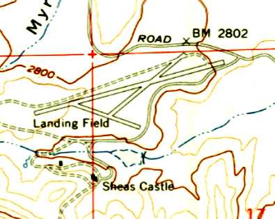
The 1957 USGS topo map depicted the “Landing Field” as having 3 runways.
The last aeronautical chart depiction which has been located of the Sky Castle airfield was on the September 1957 LA Sectional Chart.
It depited Sky Castle as a private airfield having a 3,700' paved runway.
The Sky Castle airfield was evidently abandoned at some point between 1957-58,
as it was no longer depicted at all on the March 1958 LA Sectional Chart, nor on later charts.
Aerial photos from 1959 & 1965 depicted 3 runways at Sky Castle.
In later years, through a succession of owners, the castle became a backdrop for movies,
such as the 1967 "Blood of Dracula's Castle".
The 1969 USGS topo map still depicted the “Landing Field” as having 3 runways.
A 1971 aerial view showed a change in Sky Castle's configuration, with the 2nd & 3rd runways having disappeared,
and the primary northeast/southwest runway appeared to have been paved at some point between 1965-71.
A 1974 aerial view showed Sky Castle to have a single paved northeast/southwest runway.
Sky Castle's 3rd runway had disappeared (along with most of the 2nd runway) from depiction on the 1974 USGS topo map.
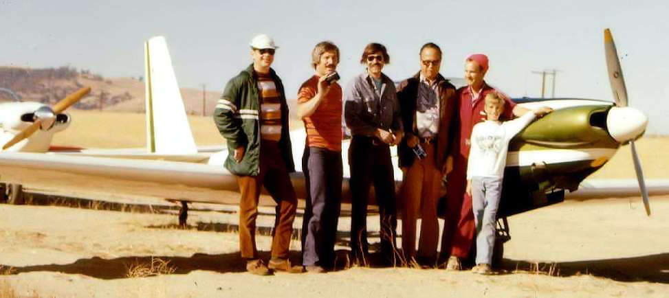
A 1975 photo of Mike Bittner, Mark Lambie, John Buckner, Charlie Webber, Charlie Gyenes, and Maurice Gyenes
in front of a Sportavia-Putzer RF5B motorglider at Sky Castle (courtesy of Collin Gyenes).
Collin Gyenes recalled, “My Dad's friend... was a caretaker at the castle in the mid 1970s.”
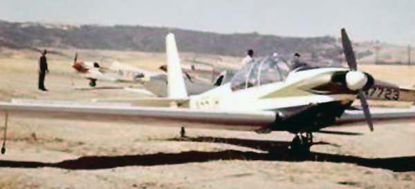
The last photo which has been located showing planes at Sky Castle
was a 1975 photo of a 2-seat Sportavia-Putzer RF5B motorglider
and 4 single-seat Sportavia-Putzer Fournier RF4Ds (courtesy of Collin Gyenes).
The Castle was also used as a setting for TV episodes,
including "Bat Masterson", "Air Wolf", "Rat Patrol" and "Buffy the Vampire Slayer".
In 1985, Sherman Oaks-based Genz Development bought the estate.
Plans were drawn up to restore the silted-up lake, install a golf course & other amenities
and divide the rest into 120 large lots for luxury homes.
The plans were halted in the early 1990s due to a change in the local economy.
The estate, which now encompasses 506 acres, sits hidden in fairy-tale fashion along a section of the California Aqueduct
about 15 miles west of Lancaster/Palmdale, invisible from the nearest thoroughfare, Munz Ranch Road.
Undoubtedly the Castle & the beautiful landscape have put indelible memories in the hearts of everyone who has visited or owned the property.
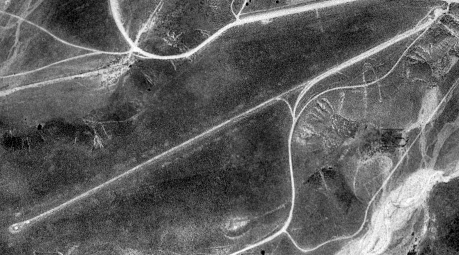
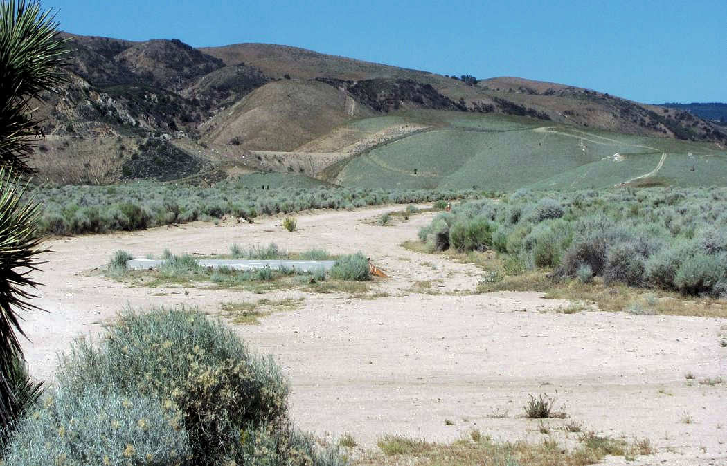
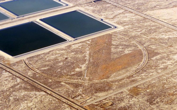
A 1994 aerial view looking northeast depicted the remains of the Sky Castle runway.
A 2005 aerial photo by Jon Karkow looking northeast at the Sky Castle runway,
with the Castle itself visible at the lower-right.
Jon Karkow reported in 2005, "The property is being sold for subdivision into a housing development – typical story.
I have never seen an airplane use the runway, though it appears in good condition."
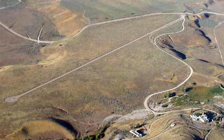
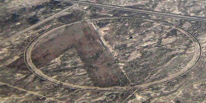
A circa 2006 aerial view looking east at the Sky Castle runway,
showing a board with a closed-runway “X” symbol which has been placed at each end of the runway.
A circa 2006 aerial view looking west at the Sky Castle runway,
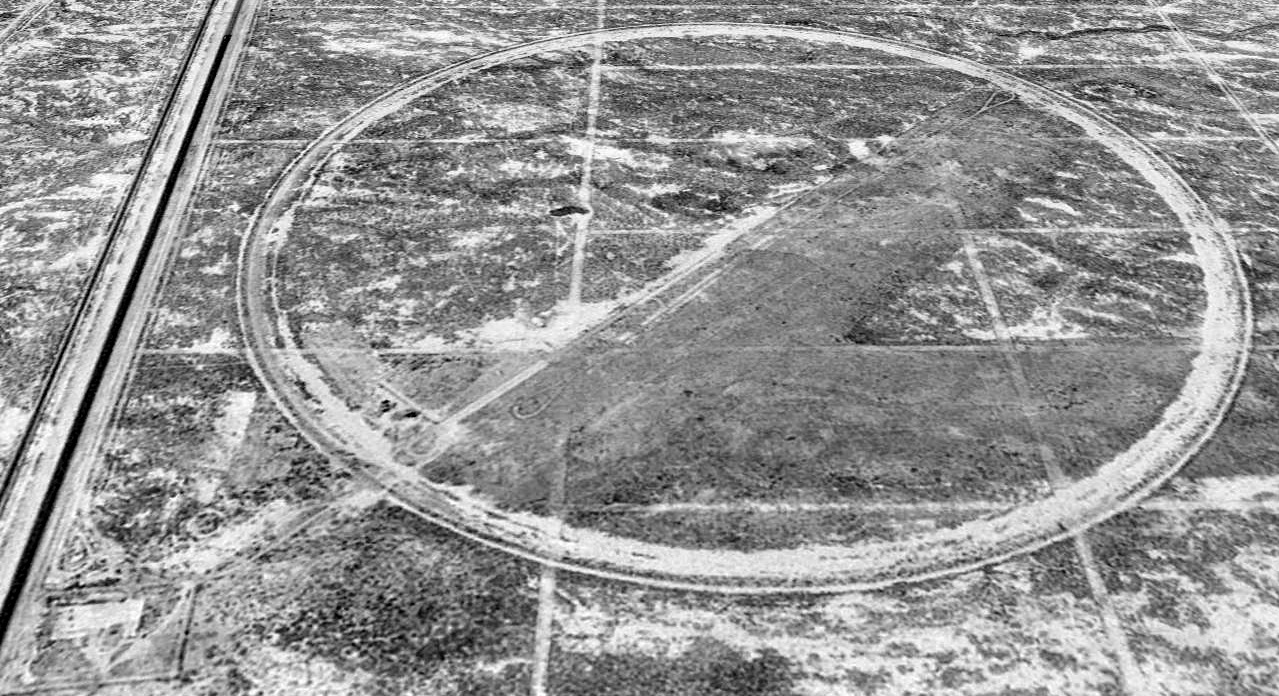
showing the remains of the airfield segmented circle on the south side of the runway.
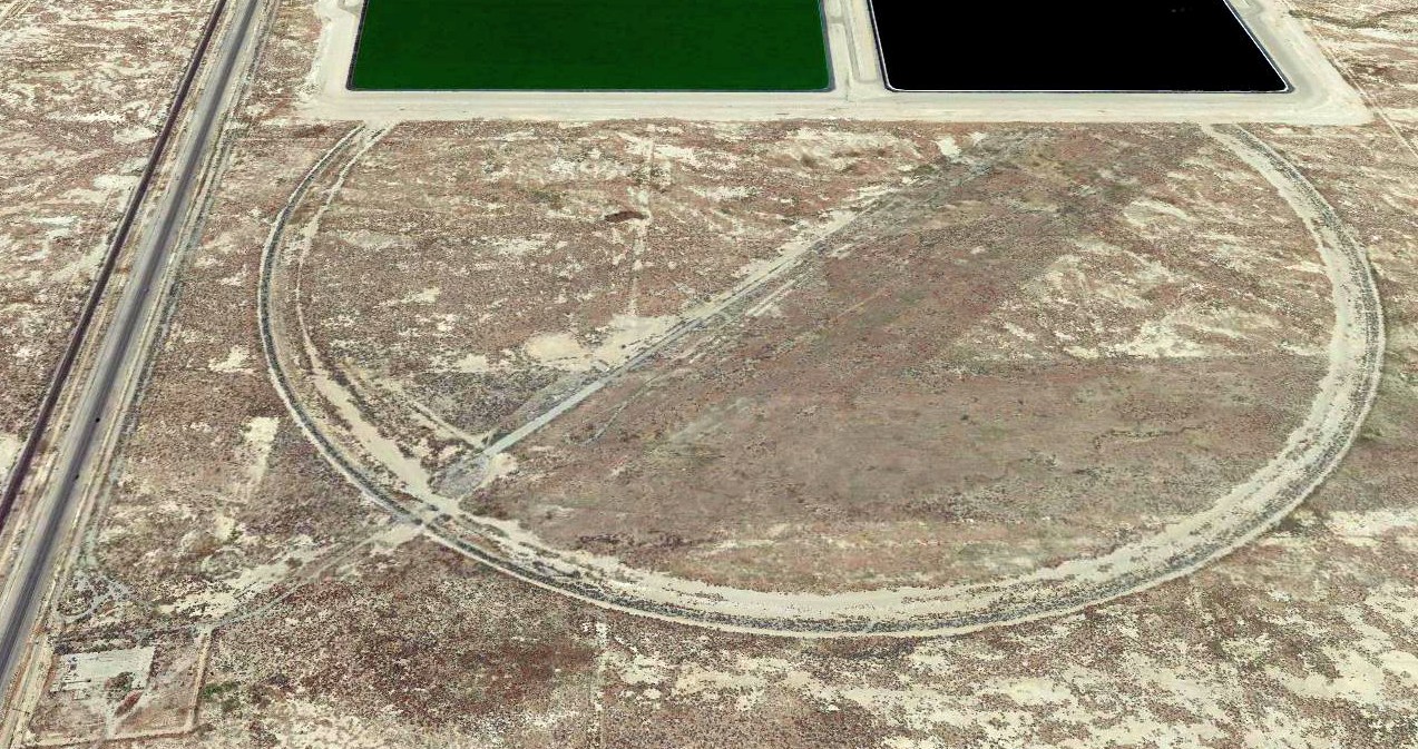
A May 2014 photo by Kurtis Clark looking west along the alignment of the Sky Castle runway.
Kurtis observed, “I could see a cement pad at the end of the runway with an 'X' on it.”
A 2017 aerial view looking northeast at the Sky Castle runway, showing the concrete pads with closed-runway “X” symbols at each end.
The site of Sky Castle is located northwest of the intersection of Munz Ranch Road & Fairmont Road.
____________________________________________________
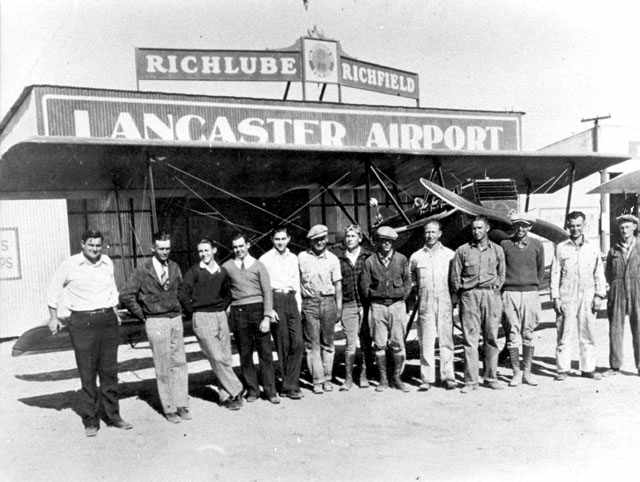
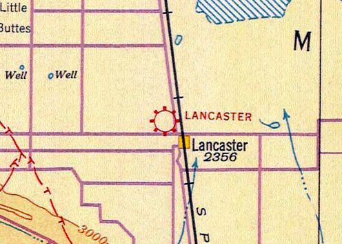
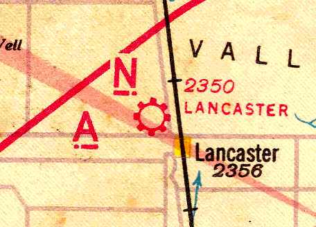
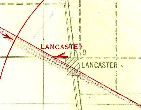
Lancaster Airport (original location), Lancaster, CA
34.705, -118.152 (North of Palmdale, CA)

Lancaster Airport, as depicted on the 1929 Rand-McNally Air Trails Map of CA (courtesy of Chris Kennedy).
The original airport for the town of Lancaster was located adjacent to the northwest side of the town.
The date of construction of Lancaster Airport has not been determined.
The earliest depiction of the field which has been located
was on the 1929 Rand-McNally Air Trails Map of CA (courtesy of Chris Kennedy).
It described Lancaster as a municipal airport, operated by the City of Lancaster.
The field was said to measure 2,000' x 1,250'.
The 1929 Airplane Landing Fields of the Pacific West (courtesy of Chris Kennedy)
described Lancaster as a municipal airport, operated by W. B. Carter.
The field was said to consist of 2 dirt runways in an “L” shape: 2,250' east/west & 1,350' north/south.
A hangar on the southeast corner was said to be marked with “Lancaster”.
The earliest aeronautical chart depiction which has been located of Lancaster Airport was on the 1932 LA Sectional Chart (courtesy of Roger Connor).
It depicted Lancaster as a commercial/municipal airport.
The 1933 USGS topo map (courtesy of the CA State University, via Chris Kennedy)
depicted the Lancaster “Landing Field” as having being oriented east/west & north/south.
Lancaster was depicted as a commercial or municipal airport on the June 1940 LA Sectional Chart (courtesy of Chris Kennedy).
The Airport Directory Company's 1941 Airport Directory (courtesy of Chris Kennedy)
described Lancaster as a commercial airport.
The field was said to consist of 2 sand runways in an “L” shape: 2,600' east/west & 2,000' north/south.
The Lancaster Airport may have been temporarily closed at some point between 1941-44
(like many other small civilian airports near the coasts due to wartime security concerns),
as it was not listed among active airfields in the April 1944 US Army/Navy Directory of Airfields (courtesy of Ken Mercer).
The August 1945 USAAF Pilot's Handbook (courtesy of Chris Kennedy)
depicted Lancaster Airport as having 2 runways: east/west & northeast/southwest.
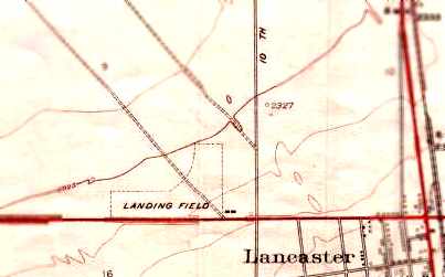
The original Lancaster Airport, as depicted on the 1947 USGS topo map.
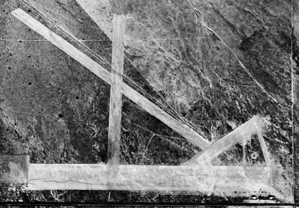
An 11/20/48 USGS aerial photo depicted Lancaster Airport as having 4 unpaved runways, and 8 single-engine light planes & a few small buildings on the southeast side.
The last chart depiction which has been located of the original Lancaster Airport as an active airfield was on the March 1952 LA Sectional Chart.
It depicted Lancaster as having a 5,000' unpaved runway.
The original Lancaster Airport was evidently closed in 1952,
as it was no longer depicted on the September 1952 LA Sectional Chart.
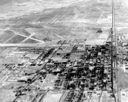
In a 1952 aerial view looking north at the town of Lancaster,
the western half of several runways of the Lancaster Airport could still be seen (top-left of picture),
but it appears as if new roads had already covered the eastern portion of the former airport.
A 1953 aerial photo showed the original Lancaster Airport having 3 dirt runways,
as well as 2 much smaller runways to the northeast (a predecessor field?).
There did not appear to be any aircraft on the field.
Patrick Ryan recalled, “The old Lancaster Airport at 10th Street West & Avenue I still had aircraft on it in mid-1954.
I remember seeing my first T-6 Texan in a dark blue paint job & other civil aircraft.”
Don Hyneman recalled, “A few years later that [the original Lancaster Airport] became housing tracts & Desert View Elementary School.
I used to walk there from the new housing tract near 10th Street West & Avenue H-8 (all dirt in the 1952 picture).
We moved in our new house in March 1955.
I always wondered why there was this nice flat dirt road at such an odd angle.”
In the 1959 aerial photo, not a trace was still recognizable of the former Lancaster Airport,
as the site had been filled in with dense housing.
The 1959 USGS topo map also depicted new streets covering the airport site.
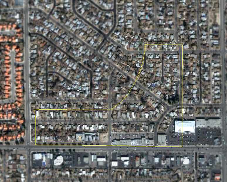
A 2006 aerial photo, annotated by Chris Kennedy to show the outline of the former Lancaster Airport.
The site of the original Lancaster Airport is located northwest of the intersection of 10th Street West & West Avenue I.
____________________________________________________
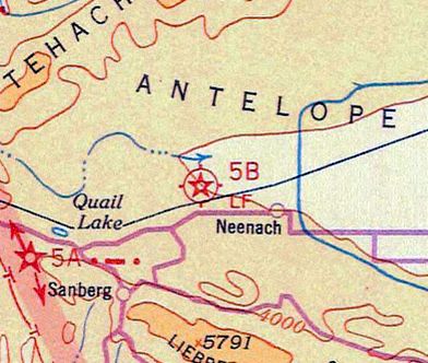
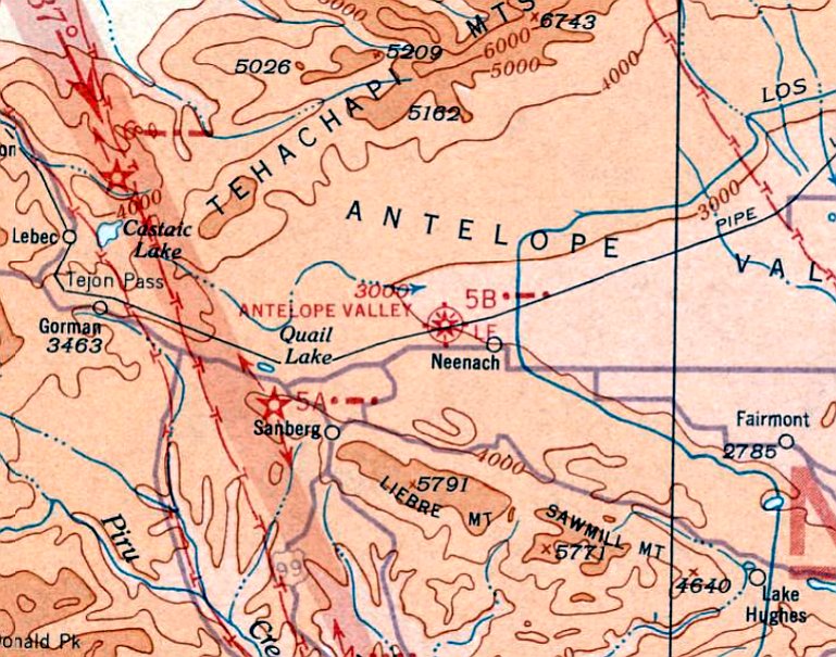
Antelope Valley Intermediate Field Site 5 / Site 5B, Gorman, CA
34.79, -118.657 (Northwest of Los Angeles, CA)

Intermediate Field 5B, as depicted on the 1929 "Rand McNally Standard Map of CA With Air Trails" (courtesy of Chris Kennedy).
Photo of the airfield while open has not been located.
This field was built as one of the Department of Commerce's network of Intermediate Fields,
established along commercial airways to serve as emergency airfields for airliners & airmail planes.
The date of construction of the Antelope Valley field has not been determined.
The earliest reference to the field which has been located
was in the Standard Oil Company's 1929 "Airplane Landing Fields of the Pacific West" (courtesy of Chris Kennedy).
It described the "Antelope Valley Field Site 5" as being a Department of Commerce Emergency field.
The field was said to consist of a 3,000' x 1,000' cleared area.
The earliest aeronautical chart depiction which has been located of the Antelope Valley Intermediate Field
was on the 1932 LA Sectional Chart (courtesy of Roger Connor), which labeled it as CAA Site “5B”.
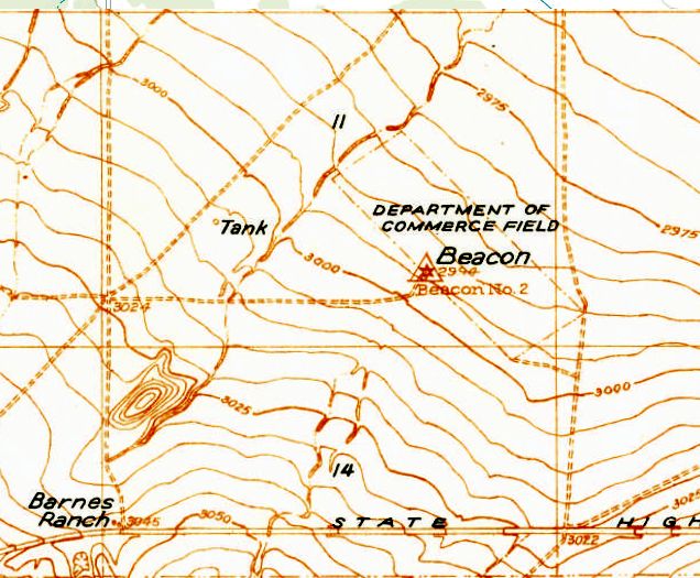
The earliest topo map depiction which has been located of the Antelope Valley Intermediate Field was on the 1932 USGS topo map (courtesy of Kevin Walsh).
It depicted “Department of Commerce Field” as a rectangular northwest/southeast outline, with “Beacon #2” on the southwest side.
The last aeronautical chart depiction which has been located of the Antelope Valley Intermediate Field was on the October 1933 LA Sectional Chart.
Ir depicted Antelope Valley Intermediate Field as CAA Site “5B”.
Antelope Valley Intermediate Field was evidently abandoned at some point between 1933-34,
as it was no longer depicted on the June 1934 LA Sectional Chart.
Like many other Intermediate Fields, it was presumably no longer needed due to advances in commercial aircraft reliability.
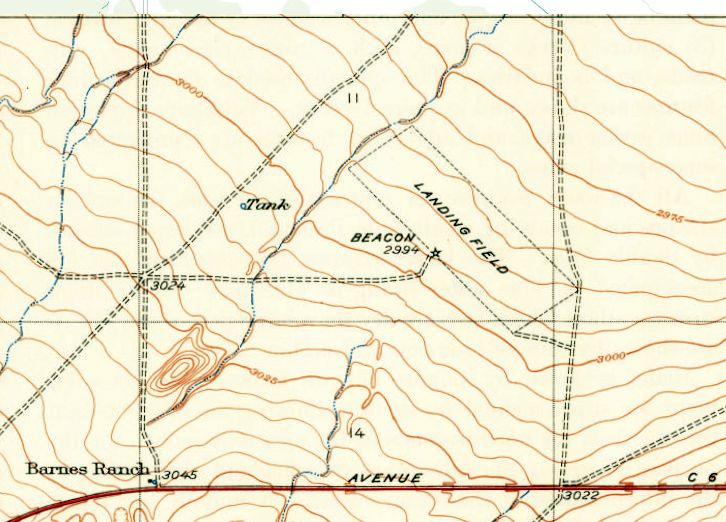
The last topo map depiction which has been located of the Antelope Valley Intermediate Field was on the 1938 USGS topo map (courtesy of Kevin Walsh).
It depicted a rectangular northwest/southeast outline, generically labeled “Landing Field”, with a beacon on the southwest side.
Antelope Valley Intermediate Field was not depicted on 1939/43/47/74/75/81 USGS topo maps.
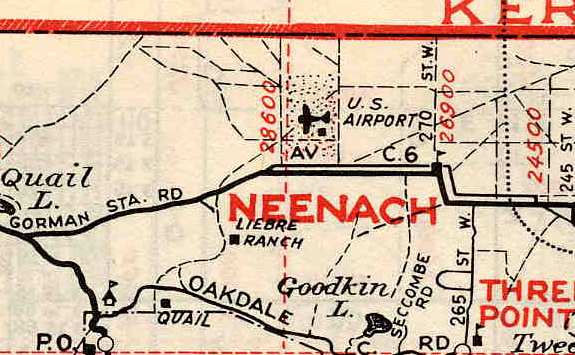
The former Antelope Valley Intermediate Field was still depicted on a 1941 street map (courtesy of Chris Kennedy), as a rectangular plot of land labeled "U. S. Airport",
along with a single building along the southeast portion of the field.
A 1952 aerial view showed the Antelope Valley Intermediate Field site was comprised of farm fields, with no recognizable trace of an airfield.
A single building sat on the southwest corner of the property - it has not been determined if this building dated from the property's days as an airfield.
The 1994 USGS aerial photo of the Antelope Valley Intermediate Field site showed that the northern half of the property
had been covered at some point between 1972-94 by a circular irrigation track.
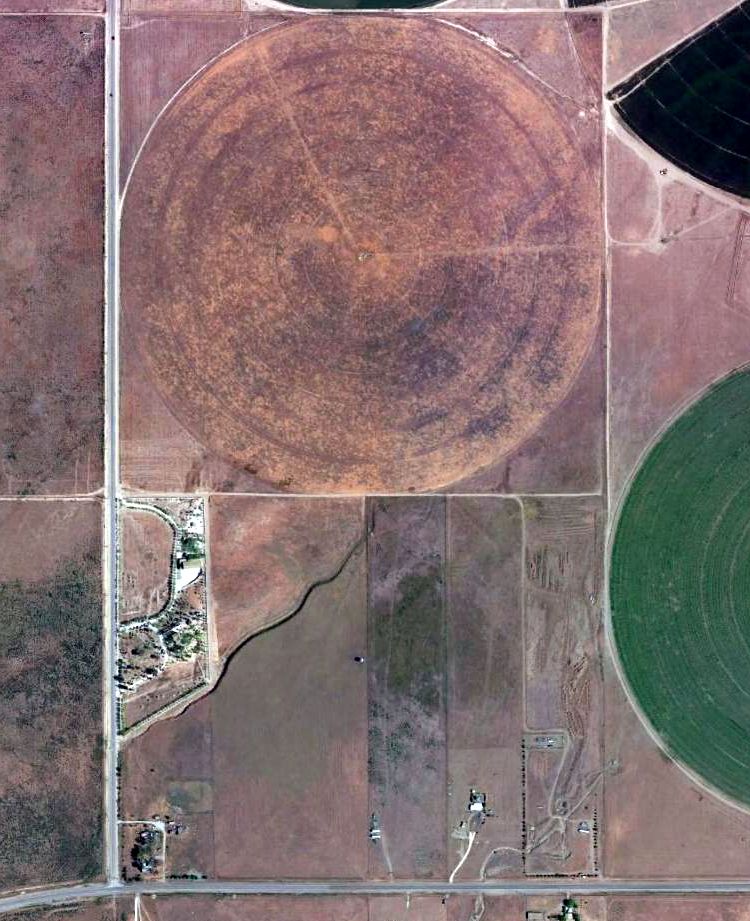
No trace of the Antelope Valley Intermediate Field was recognizable in a 2015 aerial photo.
The site of the Antelope Valley Intermediate Field is located in the extreme northwest corner of Los Angeles County,
northwest of the intersection of Route 138 & 290th Street West.
____________________________________________________
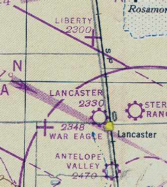
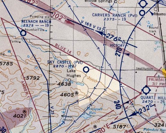
34.8, -118.16 (North of Palmdale, CA)
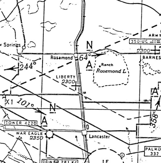
Liberty Field, as depicted on the August 1944 LA Sectional Chart.
Photo of the airfield while open has not been located.
The date of construction of Liberty Field is unknown.
It was reportedly established before WW2 by a local resident, Mr. Mallicoat, as a private training school for military pilots.
However, it was evidently built at some point between 1941-44,
as no airfield at the site was depicted on the January 1938 LA Sectional Chart, the 1941 LA Sectional Chart (courtesy of Chris Kennedy),
the 1943 USGS topo map, or the February 1944 LA Sectional Chart.
Liberty Field became one of 2 auxiliary landing fields (the other being Victory Field) associated with the Polaris Flight Academy,
which operated during WW2 from nearby War Eagle Field.
The Polaris Flight Academy was a contract flying school which used civilian instructors
to provide flight training to US & foreign military cadets.
The 1944 US Army/Navy Directory of Airfields (courtesy of Ken Mercer) described "Liberty, Army" as having a 3,900' hard-surface runway.
The earliest depiction which has been located of Liberty Field was on the August 1944 LA Sectional Chart.
It depicted Liberty as an auxiliary airfield.
The August 1945 USAAF Pilot's Handbook (courtesy of Chris Kennedy)
depicted Liberty Field as having 2 runways: east/west & northeast/southwest.
The Polaris Flight Academy (renamed the Mira Loma Flight Academy) ended its training operations at War Eagle Field in 1945,
but Liberty Field apparently remained in operation as an airfield for a few more years.
Liberty Field was still depicted as an active auxiliary airfield
on the February 1947 LA Sectional Chart (courtesy of Chris Kennedy).
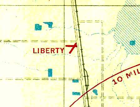
The 1947 USGS topo map depicted Liberty Field as consisting of 2 wide runways, labeled as “Landing Field”,
with 4 small buildings on the east side.
Liberty Field was evidently closed as an airfield at some point in 1947,
as it was no longer depicted on the September 1947 LA Sectional Chart.
A 11/20/48 USGS aerial photo of Liberty Field (courtesy of Brian Rehwinkel).
Brian Rehwinkel observed, Liberty Field was “probably abandoned at this point, you can still see markings on the field.
You can see what looks like a hangar (?) and another small building at the northeast corner of Liberty Field.
[Some] type of structure (it almost appears to be an igloo) seems to be present immediately south of the intersection of the 2 runways.
One of the interesting things I noticed in looking at the aerial photo of Liberty Field is the 'transparency' of the runway paving.
If you look carefully, you can see that some of the ground features that appear on landscape around the field seen to continue under the runways.
I don’t know, but I suspect the field was paved with a dust palliative (a mix of sand & oil or a light layer of asphalt).”
Liberty Field was still depicted (on the western edge) of a 1950 Pocket Atlas (courtesy of Dan MacPherson),
but that does not necessarily indicate that it was still an open airfield at that point.
In the 1950s the US Rubber Company constructed a 3,500' diameter circular automotive testing track,
roughly superimposed over the center of the former airfield.
“They would bring tires up from the Los Angeles factory which has an amazing history all it's own”, according to John Smith.
A 1953 aerial photo depicted the circular test track, within which was still visible the outline of the 2 runways.
One small building appeared to remain from the site's airfield days, within the test track, on the southeast side of the runways.
Nothing was depicted at the site of Liberty Field on the 1954 USGS topo map.
Patrick Ryan recalled, “At Liberty Field there was a building that looked like a very large garage back in the mid-1950s
with 'B.F. Goodrich' across the upper east side of the building.”
The 1957 USGS topo map depicted the circular “Test Track” covering the site of Liberty Field, and no longer depicted the runways.
Dodge acquired the test track from US Tire (Uniroyal) in the 1960s, according to locals (via John Smith).
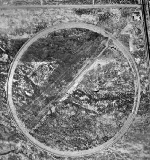
A 1972 aerial view depicted the original Liberty Field's 2 runways, with the more recent circular test track having been built over it,
and the remains of a possible hangar at the northeast corner.
A 1974 aerial photo showed that the last airfield building appeared to have been removed at some point between 1972-74.
“The test track was last maintained by the Dodge Motor Company”, said John Smith.
“It closed down completely in the 1970s when they moved to facilities further out in the desert.”
A 1994 USGS aerial view looking south at Liberty Field depicted the remains of 2 former runways, over which the circular test track was later constructed,
and the remains of a possible hangar at the northeast corner.
The entrance to Liberty Field, as photographed by Rick Jackson in 2003.
"This is on Sierra Highway, just before the corner of Avenue B.
You can see the red entrance walkway to the cement pad behind it.
You can't see it in this photo, but there are curbs coming out from both sides of the beginning of the walkway.
I don't know if this is from WW2 or US Rubber.
You can't see this from Sierra Highway because a drainage ditch & berm have been built in front of it."
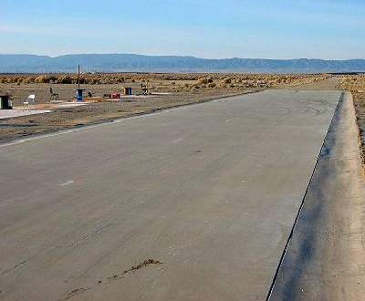
A 2003 photo by Rick Jackson.
"Liberty Field looks like it's become home to model airplane flyers.
This section has been nicely paved. This is looking towards the SW.
Towards the end of the paved section is an asphalt section, with another paved section following that."
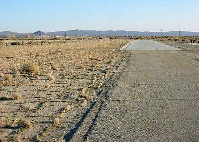
A 2003 photo by Rick Jackson. Rick noted, "This is looking from the asphalt section towards the northeast.
On the left is part of the original runway, and US Rubber test area."
Rick Jackson visited the site of Liberty Field in 2003.
He reports that several sections of relatively new looking pavement appear to have been constructed for the use of model aircraft.
"The circular track around the runway is up on a berm.
From what I saw it's still drivable, as long as you don't mind getting your car scratched from the bushes.
There's more concrete pads around, but who knows from what era."
John Smith visited the site of Liberty Field in 2005, and reported,
“The test track is actually inclined to about a 40 degree angle & is surmounted by a highly decayed paved service road.
When we drove down into the bowl of the test track, it's looked much like the photos [posted above].
The entire bowl area is paved to varying degrees,
but is decaying badly away from the track section & the central skid pads (now concrete model airplane runways).
The northeast/southwest runway is now heavily overgrown & is nearly unrecognizable by casual examination.
Only close viewing or airborne observation would indicate an airfield existed there.
All extant building foundations nearby all date to the US Tire era.
We were unable to find possible sites for the airfield's administration building or hangars
(most likely on the north side of the field near or across Avenue B).
Squatters are living in & around the area & we didn't wish to risk confrontation.”
Hal Arbogast reported in December 2005, “I've just completed a metal detector sweep
of the East/West Liberty Field runway (in the dirt on the north side of the runway, Avenue B side),
having swept the Northeast/Southwest runway (in the dirt on the eastern side) about a month ago.
I found one piece of re-bar in the latter sweep, but today recovered numerous old steel/iron construction bolts,
carriage bolts, etc. on the Avenue B side of the East/West runway
that bolsters your observation that hangars & administrative offices existed near Avenue B.
I even found the remains of a common table knife (no handle though).
I also found several areas of tarmac perpendicular to the East/West runway (toward Avenue B)
where aircraft mooring/parking possibly occurred,
and a cable 'termination' device possibly indicating the existence of aircraft tie-down cables.
Having prowled ruins in the desert Southwest for 20+ years,
I firmly believe the concrete pads I've come across during my sweeps on Liberty Field are all of the tire test track vintage...
typically pre-WWII structures were raised structures supported by partial concrete (or other materials), and not full concrete foundations.”
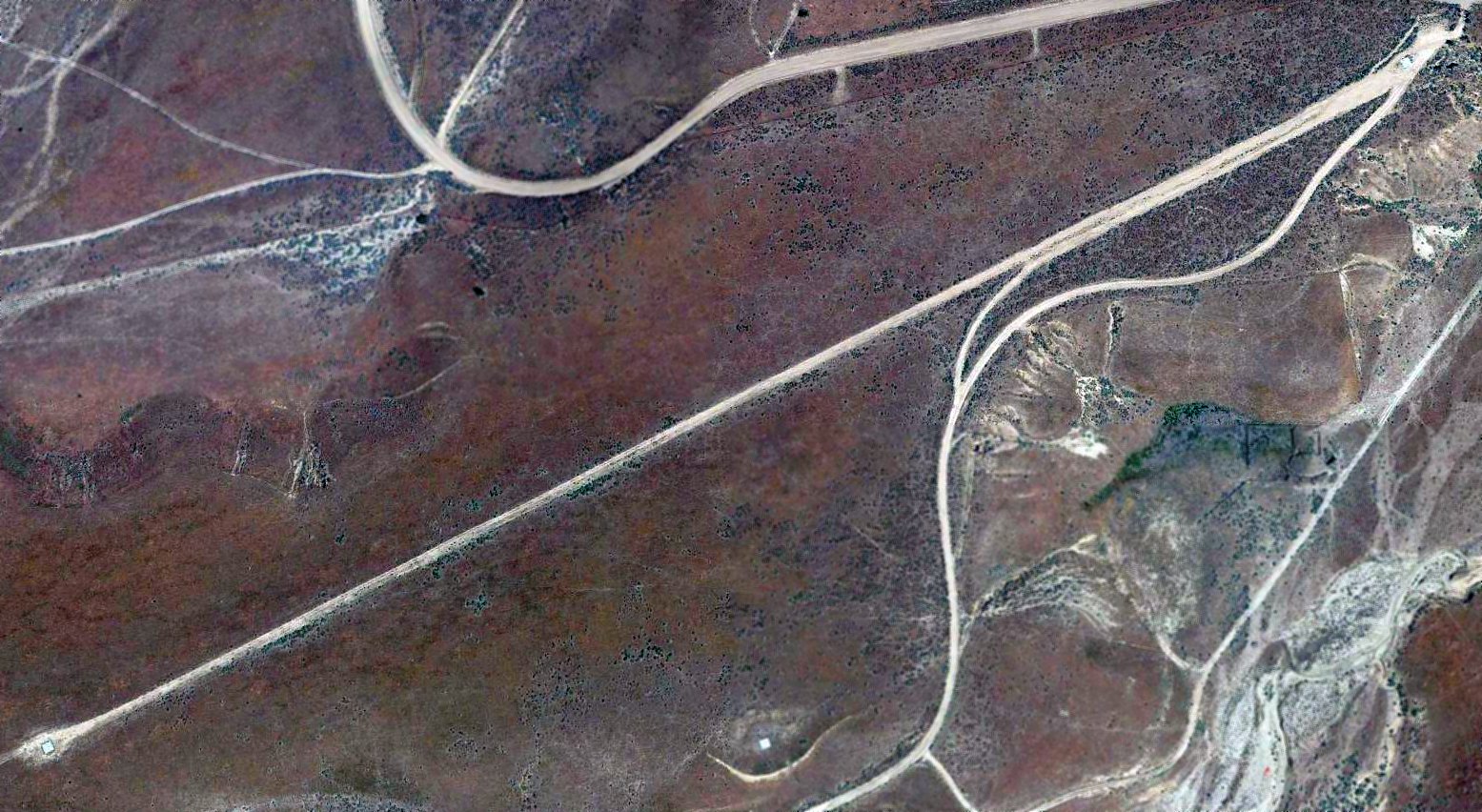
A 2007 aerial view by Philip Pesce looking northeast at the site of Liberty Field.
Alan Radecki reported in 2008, “Liberty Field... The entire square mile plot of land, along with the square mile immediately south of it,
has been fenced off & will be plowed up for the construction of the expanded waste water treatment plant that serves the area.
Sad to see the airfield go!”
An October 2014 aerial view by Dustin Mosher looking southwest at the site of Liberty Field,
with the southern portion covered by a wastewater treatment facility.
Dustin observed, “The old runway outlines are still clearly visible. There is also a disused private strip to the west of the airport, opposite Highway 14.”
A 2017 aerial view looking south at the site of Liberty Field.

A March 2021 photo looking southwest at the possible hangar foundation at the northeast corner of the Liberty Field site.
The site of Liberty Field is located southwest of the intersection of Sierra Highway & West Avenue B, 5 miles south of Rosamond.
Thanks to Dan MacPherson for determining the location of Liberty Field.
See also: http://www.av.qnet.com/~carcomm/wreck19.htm
____________________________________________________
34.785, -118.27 (North of Palmdale, CA)
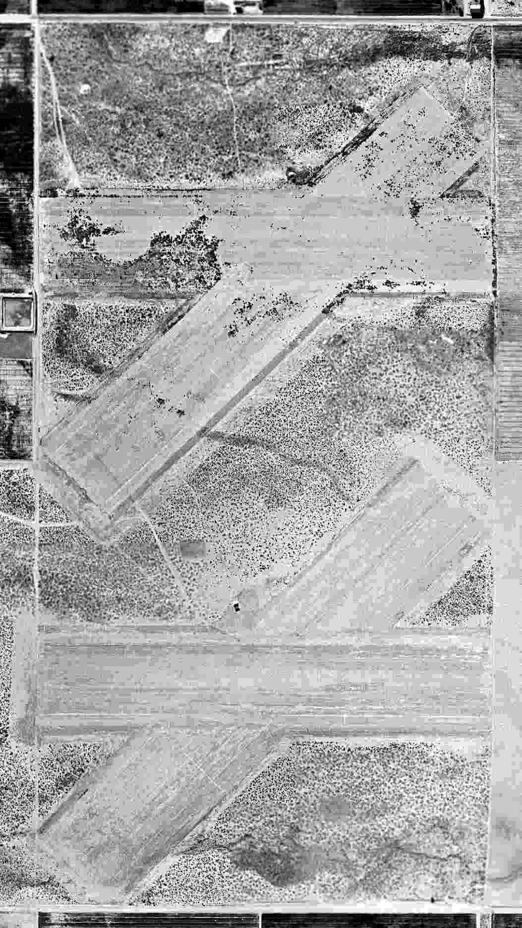
A 7/22/43 National Archives aerial view looking north at Victory Auxiliary Field (courtesy of Brian Rehwinkel).
Victory Field was one of 2 auxiliary landing fields (the other being Liberty Field)
used during WW2 to support the training operations at Polaris Flight Academy, based at the nearby War Eagle Field.
The Polaris Flight Academy was a contract flying school which used civilian instructors to provide flight training to US & foreign military cadets.
Victory Field was evidently established at some point between 1941-43,
as it was not listed among active airfields in The Airport Directory Company's 1937 Airport Directory (courtesy of Bob Rambo),
nor depicted on the 1941 USGS topo map.
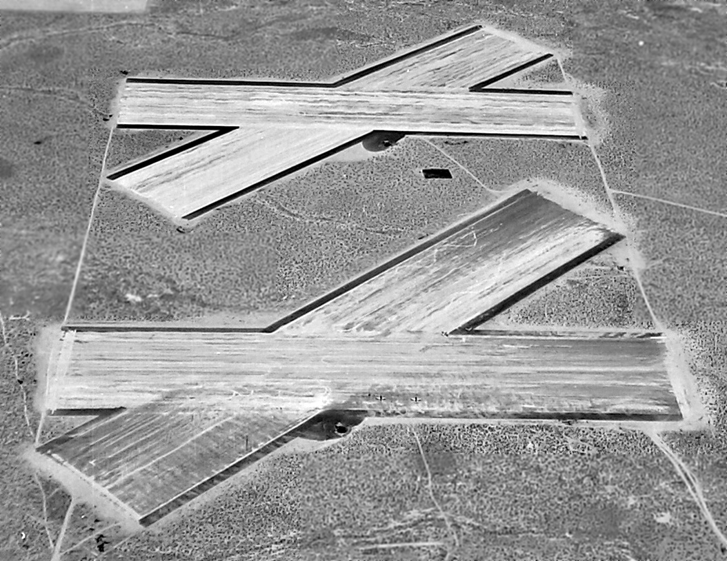
The earliest depiction which has been located of Victory Field was a 7/22/43 National Archives aerial view (courtesy of Brian Rehwinkel),
showing an unusual airfield configuration of a total of 4 runways, divided into 2 unconnected pairs of east/west & northeast/southwest strips.
A small paved area sat to the south of each runway intersection, each with a small building (a shack?), but there were no hangars.
Brian Rehwinkelin noted, “Clearly, the fields were in operation & you can see several aircraft parked on the southernmost east/west runway.
These were pretty big runways & they really must have been in the middle of nowhere in 1943.”
However, Victory Field was not yet listed in the April 1944 US Army/Navy Directory of Airfields (courtesy of Ken Mercer).
The Polaris Flight Academy (renamed the Mira Loma Flight Academy) ended its training operations at War Eagle Field in 1945,
and at this point it is presumed that Victory Field was abandoned (at least for a few years).
It was not depicted at all on the 1945 or 1947 LA Sectional Charts (courtesy of Chris Kennedy) nor on the 1947 USGS topo map.
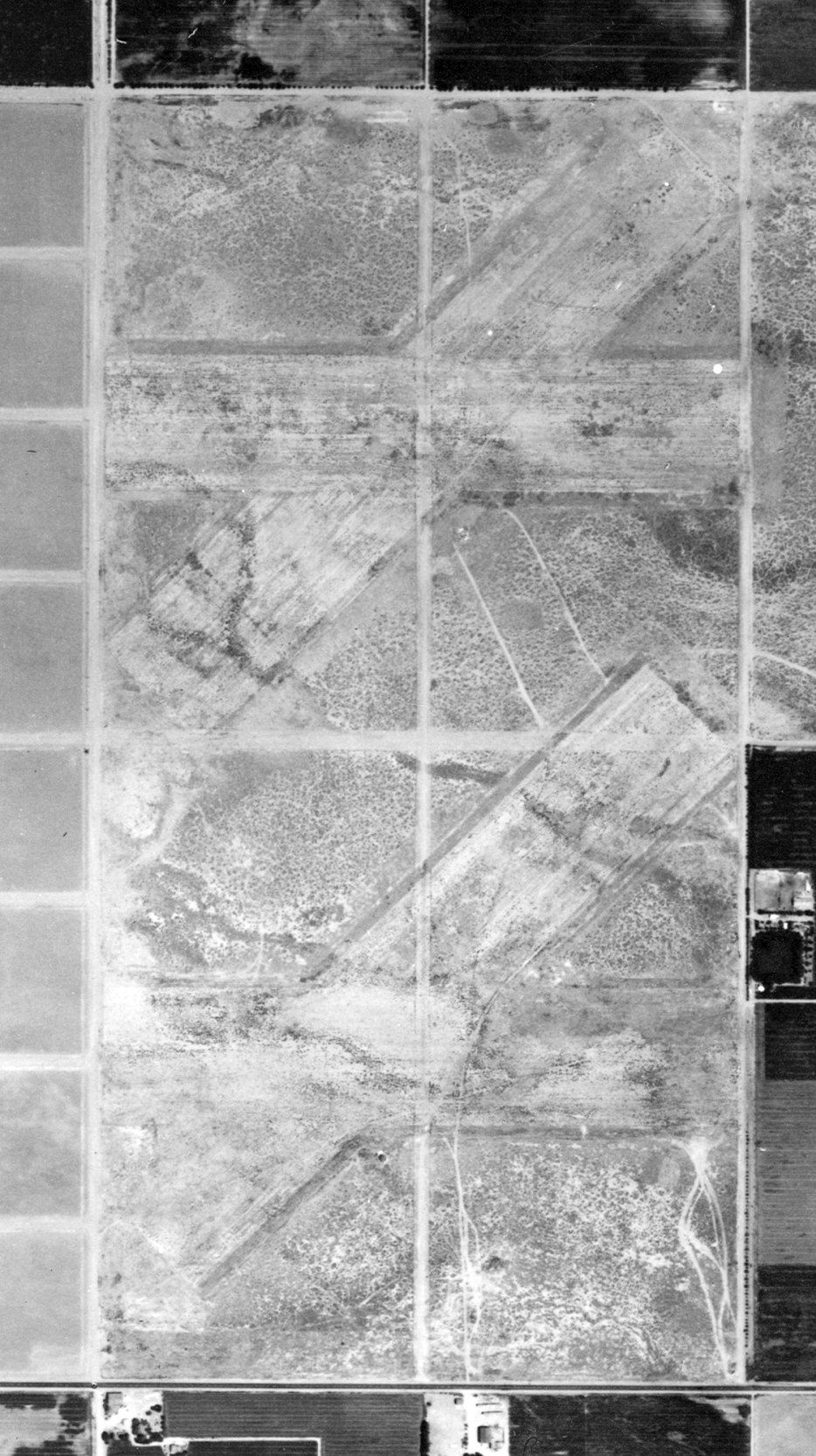
A 11/20/48 USGS aerial photo of Victory Field (courtesy of Brian Rehwinkel).
Brian Rehwinkel observed, Victory Field was “probably abandoned at this point, you can still see markings on the field.
The photo for Victory Field does not show any identifiable building,
although there seems to be a small structure immediately south of the intersection of the pair of runways making up the south field for Victory Field
and the same type of structure (it almost appears to be an igloo) appears immediately north of the intersection of the northern runways that make up Victory Field.”
Victory Field was not depicted at all on the 1949 LA Sectional Chart (courtesy of Chris Kennedy).
Victory Field was apparently reopened as a civilian airport at some point between 1949-54,
as the September 1954 LA Sectional Chart (courtesy of Chris Kennedy) depicted "Victory" as a civilian public-use airfield.
The Aerodromes table on the chart described Victory as having a total of 4 runways, with the longest being a 3,200' "Field mix" strip.
A 1954 aerial photo showed the remnants of Victory Field: a total of four 2,800' runways, divided into 2 pairs of east/west & northeast/southwest strips.
Victory Field was evidently closed (for reasons unknown) at some point between 1954-58,
as it was no longer depicted as an airfield on the March 1958 LA Sectional Chart (according to Chris Kennedy).
However, the 1958 Sectional did continue to depict a reporting point at that same location labeled "Victory".
A 7/14/59 aerial photo (from the UCSB Photo Library) showed the remnants of Victory Field's 4 runways.
No airfield at this location was depicted on the 1959 USGS topo map.
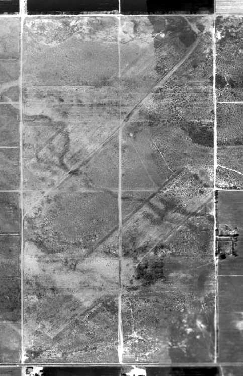
A 1972 aerial photo showed the remnants of Victory Field: a total of four 2,800' runways,
divided into 2 pairs of east/west & northeast/southwest strips.
Leigh Kelly reported in 2005 that she had heard 2nd-hand that “remnants of Victory Field were still visible”
when an acquaintance first moved to Little Butte (the more-recent-airfield adjacent to the northeast side of the site of Victory Field).
Todd Schultz remarked in 2005, “Depending on the time of year, the runways completely blend in with the desert
but after all the rain this year most of the weeds can’t grow through the pavement.
The runways look like they were paved or hard packed tar-gravel mix.
There are remnants of 2 concrete buildings on the south side of each set of runways that have deteriorated & fallen down.”
A 2015 aerial view looking northwest showed the remnants of Victory Field's multiple runways were still recognizable.
The site of Victory Field is located northeast of the intersection of West Avenue D & 90th Street West.
____________________________________________________
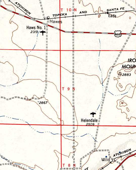
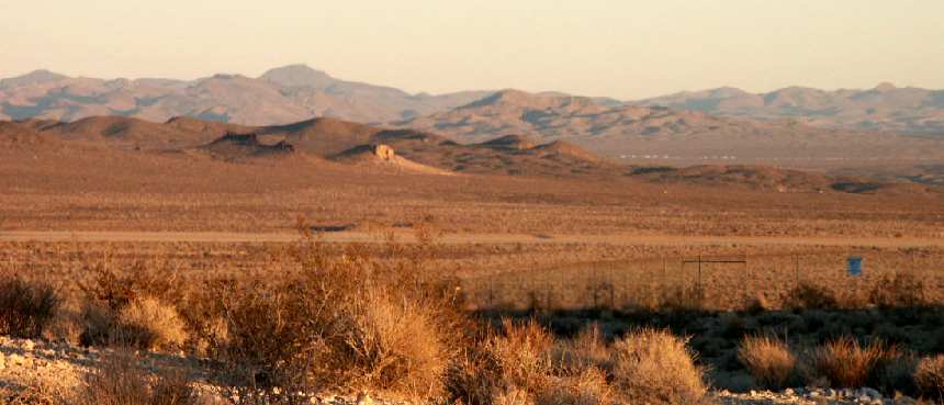
Helendale Auxiliary Army Airfield #2 / Helendale Airport, Helendale, CA
34.82, -117.3 (East of Palmdale, CA)
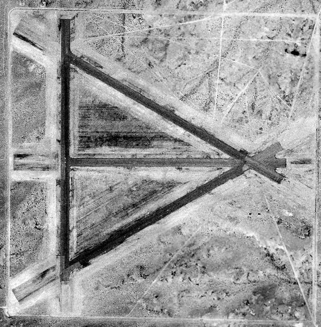
A 1942 aerial view of the Helendale airfield (courtesy of Bob Anderson).
Photo showing the airfield while in use has not been located.
This airfield was established in 1942 as a satellite field for Victorville AAF (later renamed George AFB).
The earliest depiction which has been located of the Helendale airfield
was a 1942 aerial view (courtesy of Bob Anderson).
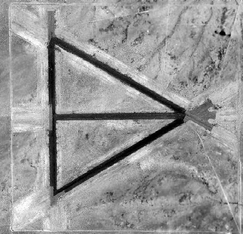
It depicted the field as having 4 paved runways laid out in a triangular configuration.
The Helendale aifield was not yet depicted on the February 1944 LA Sectional Chart.
The 1944 US Army/Navy Directory of Airfields (courtesy of Ken Mercer) described "Helendale Aux. #2, Army" as having a 5,600' hard-surface runway,
and the remarks included, "Auxiliary to Victorville AAF."
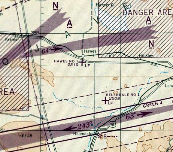
The March 1945 LA Sectional Chart depicted “Helendale #2” as an auxiliary airfield.
Helendale continued to operate as a satellite field for Victorville AAF until the end of WW2.
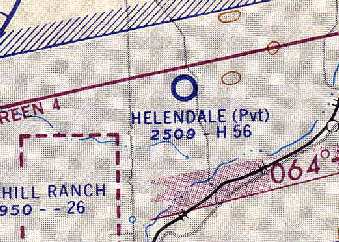
Helendale was reused after WW2 as a private civilian airfield.
Helendale Airport, as depicted on the 1948 USGS topo map.
The February 1949 LA Sectional Chart depicted Helendale Airport as having a 5,600' paved runway.
A 6/1/52 USGS aerial photo depicted Helendale as having 4 asphalt runways, but did not show any sign of recent usage.
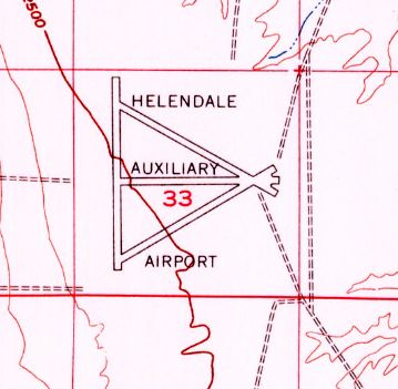
The 1956 USGS topo map depicted Helendale Auxiliary Airport as having 4 paved runways.
The 1960 LA Sectional Chart (courtesy of Chris Kennedy)
depicted Helendale as a private airfield having a 5,600' hard-surface runway.
It was listed among active airports in the 1962 AOPA Airport Directory,
with a single 3,600' paved runway, but with the note "Closed to public".
A 1964 aerial view (courtesy of Bob Anderson)
depicted Helendale as being basically unchanged from its depiction in 1942,
with 4 paved runways laid out in a triangular configuration.
Helendale was depicted as an active airfield on the 1967 LA Sectional Chart (courtesy of Chris Kennedy).
Strangely, it was not labeled as a private airfield on the 1967 Sectional,
but the remarks block in the Aerodromes table says "Land at pilots own risk."
It was described as having 4 runways, with the longest being a 4,459' asphalt strip.
A 1972 aerial view showed the Helendale airfield to remain in fairly decent shape.
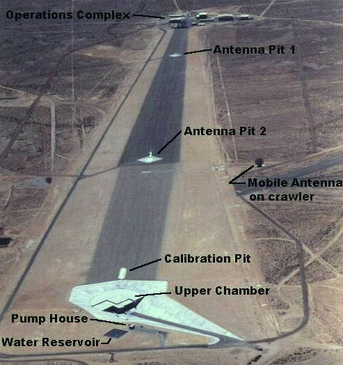
Starting in 1983, the runways of this WW2-era airfield were reused as a radar cross section testing range by Lockheed.
It was the most mechanically sophisticated of the Mojave Desert RCS ranges, and was expanded in 1985.
Its official name was the Helendale Avionics Facility
and was owned & operated by the Lockheed Martin Skunk Works.
One of the 3 paved runways (4/22, 4,600') of the old airstrip was still maintained & operational, and had lighting for night operations.

A 1994 USGS aerial view looking northeast showed the runways of the Helendale's airfield on the northwest (left side) & the Helendale RCS range on the southeast side (right).
A 1996 aerial view looking south along the Helendalte radar test range.
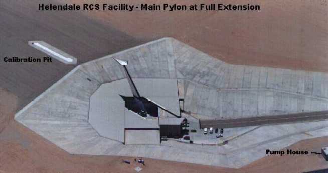
Close-up of the main pylon, used for mounting stealth aircraft shapes for RCS testing
(note generic stealth aircraft shape mounted on top).
The pylon is actually retractable, into a giant silo beneath,
to conceal aircraft configurations from reconnaissance satellites passing overhead.
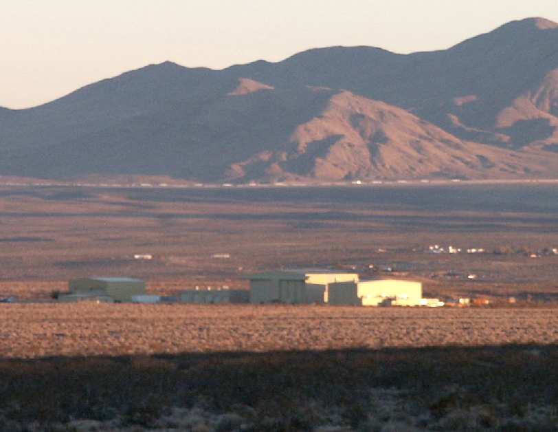
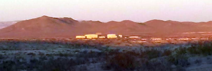
A 2003 photo by Tim Tyler of the hangars & buildings at the Helendale facility.
Tim reported that it consisted of a "Large, open area, with no signs of life - two large mesh microwave dishes on pedestals.
Both were horizontal, one pointed north, the other pointed east. Several small & large cream colored buildings are also on the site.
I was able to see the facility for quite a while as I headed south on Helendale Road.
I’m assuming the gated entrance I saw off Helendale Road is not used much.
Helendale Road is dirt, and very bumpy. No signs of any people or activity."
He added that signs along the fence said "No Trespassing. Lockheed Corp." in an old looking font.
A 2003 photo by Tim Tyler of the remains of a runway at Helendale.
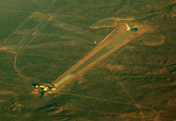
A December 2004 aerial photo by Ando Hiroshi looking northwest at the Helendale RCS range & the runways of the airfield.
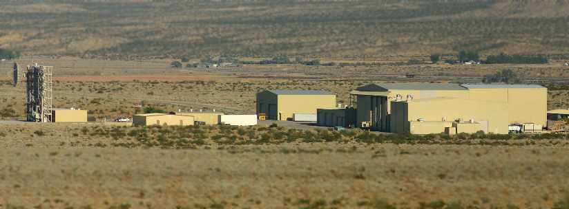
A 2005 photo by Joshua Nyhus of the front of the Helendale facility buildings.
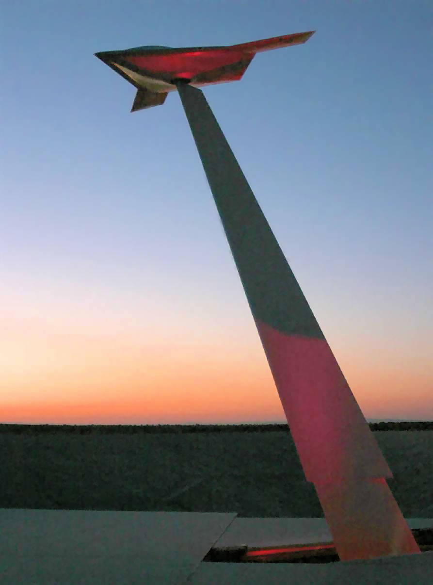
An undated photo from a 2005 press release showing Lockheed Martin's pole model of the X-47B unmanned combat aircraft
mounted & in position for testing as the sun sets at the Helendale Measurement Facility.
A 12/22/14 photo by Shannon Stimmel of the Helendale facility buildings.

A 2023 aerial view looking northeast showed the runways of the Helendale's airfield on the northwest (left side) & the Helendale RCS range on the southeast side (right).
The Helendale AAF site is located 5 miles north of Helendale & just west of the Mojave River.
It has a site address of 17452 Wheeler Road, Helendale CA 92342.
Thanks to Walt Witherspoon for information about Helendale.
____________________________________________________
____________________________________________________
This site covers airfields in all 50 states.