
Abandoned & Little-Known Airfields:
California: Eastern Riverside County
© 2002, © 2025 by Paul Freeman. Revised 7/20/25.
This site covers airfields in all 50 states: Click here for the site's main menu.
____________________________________________________
Please consider a financial contribution to support the continued growth & operation of this site.
For a 10th year, the CA pages of this website are sponsored by the California Pilots Association:
(Original) Desert Center Airport (revised 3/26/22) - Eagle Mountain Airfield / Metropolitan Water District Airstrip (revised 6/5/22)
Eagle Mountain Pumping Station Airfield (revised 7/20/25) - Gary Field / W.R. Byron Airport (revised 9/16/22) - Harvey's Airport / Skyway Airport (revised 8/11/19)
Heron Airport (revised 7/29/20) - Midland Airfield (revised 9/1/16) - Rice AAF / Rice Airport (revised 9/12/23)
____________________________________________________
Rice Army Airfield / Rice Airport, Rice, CA
34.07, -114.82 (East of Los Angeles, CA)
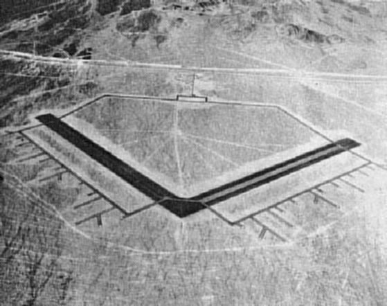
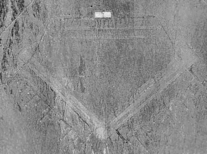
A 1942 aerial view looking north at Rice AAF (courtesy San Bernardino County Library, via Rick Jackson, enhanced by Bill Grasha).
No airfield in Rice was yet depicted on the LA Sectional Charts from 1932 through April 1942.
According to the book "The Desert Training Center/CA-AZ Maneuver Area, 1942-44" (via Rick Jackson),
the "Rice Municipal Airport" was acquired by the Army's IV Air Support Command in 1942, and was operational by 1942.
This presumably means that it existed before WW2 as a civil airport.
Rice Army Airfield was a subbase of Thermal Army Airfield.
The airfield consisted of 2 paved 5,000' runways & numerous dispersal pads extending off the runways to the south.
In order to house the more than 3,000 men, the Army constructed barracks & dormitories.
Rice AAF was described in the 1944 US Army/Navy Directory of Airfields (courtesy of Ken Mercer) as having 5,500' runways.
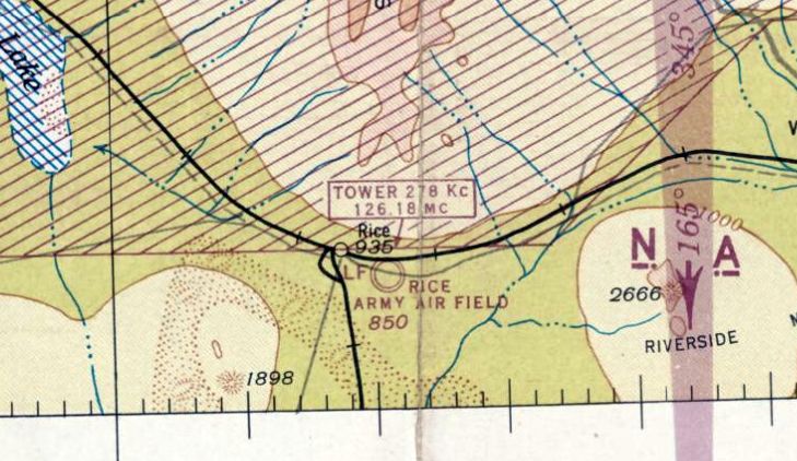
The earliest aeronautical chart depiction which has been located of Rice AAF was on the February 1944 LA Sectional Chart,
which depicted Rice AAF as a military airfield.
By 1944, the airfield was assigned to March Field as a subbase.
According to a history of the 4th Air Force (courtesy of Francis Blake), operations at Rice Field were ended by 8/2/44,
and the field was declared surplus on 10/31/44.
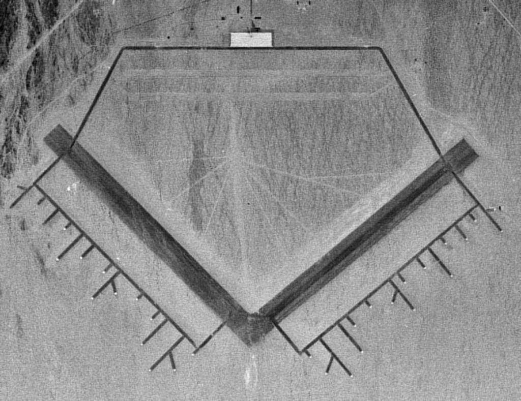
A 6/25/48 USGS aerial view (enhanced by Bill Grasha) showed the extensive facilities of Rice AAF evidently abandoned.
The Rice airfield was not depicted at all on the February 1949 LA Sectional Chart (according to Chris Kennedy).
Apparently, the Rice airfield was reused starting at some point in 1949 as a civilian airport,
as that is how it was depicted on the 1949 Gila River World Aeronautical Chart (courtesy of Donald Felton).
Rice was described as having a 6,100' hard-surface runway.
Bob Howe reported, "My grandfather ran a small flight school there. After WW2 he (the Revered Gilbert Howe) taught missionaries to fly.
I found out about Rice Field while listening to an old recording. In this tape, he mentioned taking over a hangar from the military."
Rice was depicted as an active public-use airfield on the March 1952 San Diego Sectional Chart (courtesy of Chris Kennedy).
The chart depicted Rice as having a 5,000' paved runway.
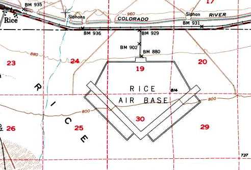
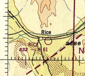
The 1954 USGS topo map depicted Rice Air Base as having 2 paved runways, taxiways, and a ramp.
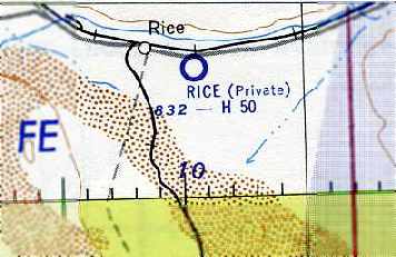
The status of the Rice airfield evidently changed to a private airfield at some point between 1952-55,
as that is how it was depicted on the September 1955 San Diego Sectional Chart (courtesy of Chris Kennedy).
The Rice Airport was evidently abandoned (for reasons unknown) at some point between 1955-58,
as it was no longer depicted at all on the March 1958 LA Sectional Chart (according to Chris Kennedy).
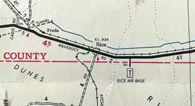
“Rice Air Base”, as depicted on a 1967 road map (courtesy of Kevin Walsh).
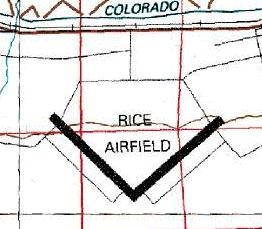
The 1980 USGS topo map depicted Rice Airfield as having 2 paved runways & parallel taxiways.
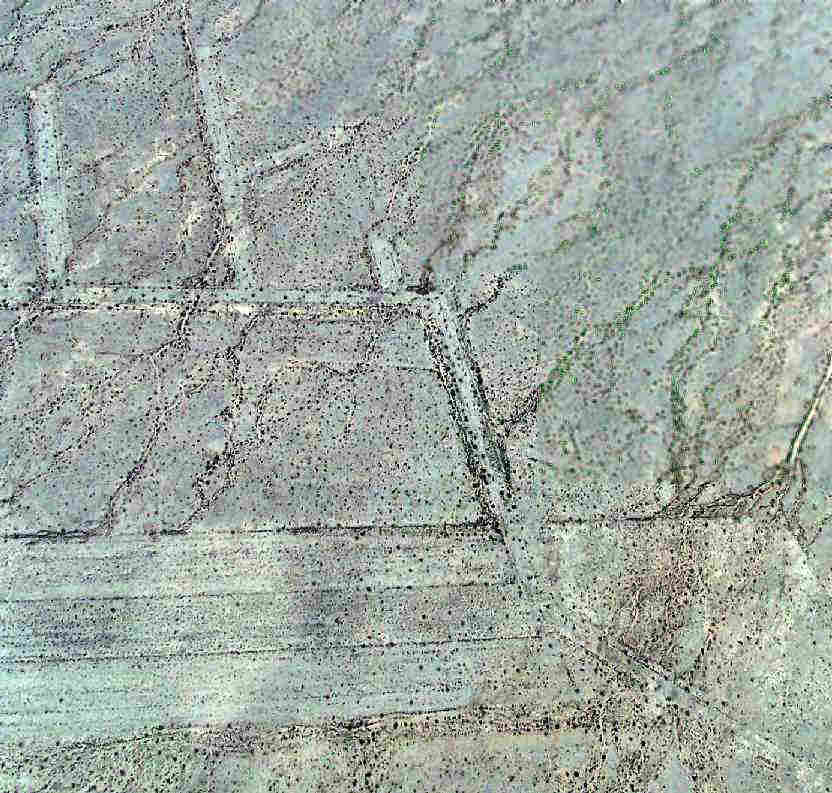
A 1996 USGS aerial photo (enhanced by Bill Grasha) showed Rice's ramp, runways & dispersal pads as barely discernible,
due to the low contrast between the airfield pavement & that of the surrounding desert.
The Rice airfield was depicted as an abandoned airfield on the 1998 World Aeronautical Chart.
Michael Grube visited the site of Rice in 2002.
He reports, "I circled the perimeter of the field & the only concrete leftover is a large pad in the north.
The rest is nothing more than desert gravel with only fewer tumbleweeds than the rest.
There are no signs that the runways have ever been paved at all. No buildings or other structures remained."
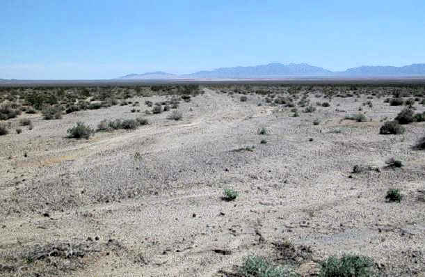
A 2003 photo by Chris Kennedy (enhanced by Bill Grasha) looking southeast at the abandoned NW/SE runway at Rice.
Chris reported that "the Rice airfield is in even worse shape, at least the runways.
Strangely, the taxiways & parking areas are in much better shape.
The parking pads, which are at the end of the short extensions off of the main taxiways appear to be concrete.
The taxiways seem to have once been oil over gravel & are easily discernible
The picture of one of the runways shows that it just looks like a road across the desert.
I did see the remains of some white paint at the end of one of them that might have been a runway number at one time.
The are some old foundations & a very large concrete parking ramp."
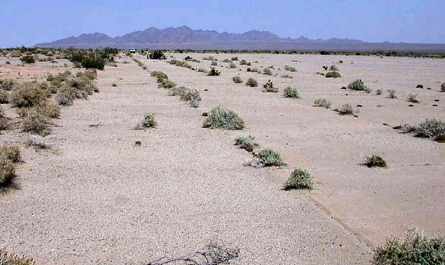
A 2003 photo by Don Barrett (enhanced by Bill Grasha) of the remains of the concrete parking pad
(which also still contained metal tie-down rings embedded in the concrete) at Rice.
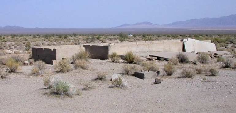
A 2003 photo by Don Barrett of the remains of a building foundation at Rice.

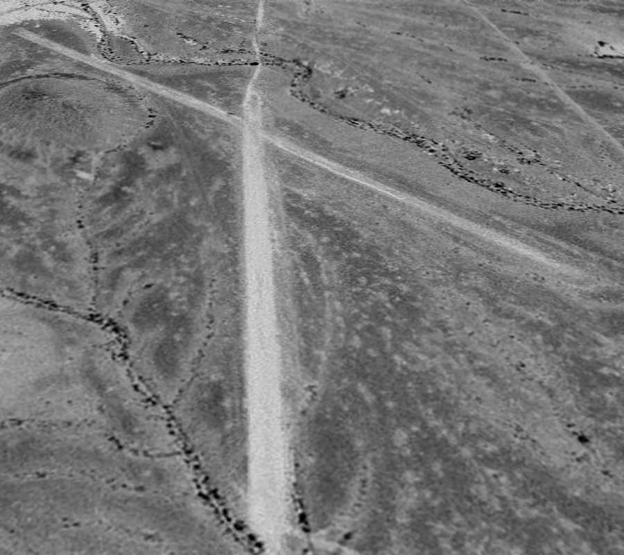
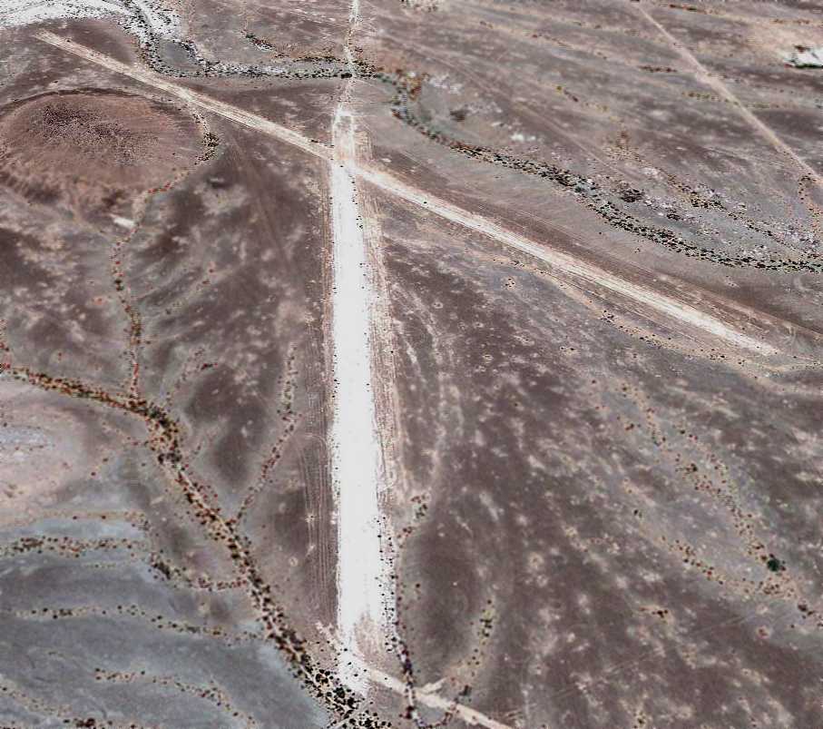
A 2006 aerial photo by Joe Merkert (enhanced by Bill Grasha) looking north at the remains of Rice AAF.
A 2006 aerial photo by Joe Merkert (enhanced by Bill Grasha) of the southern point of the “V” where the 2 runways intersected,
showing the pads used for aircraft tiedowns.
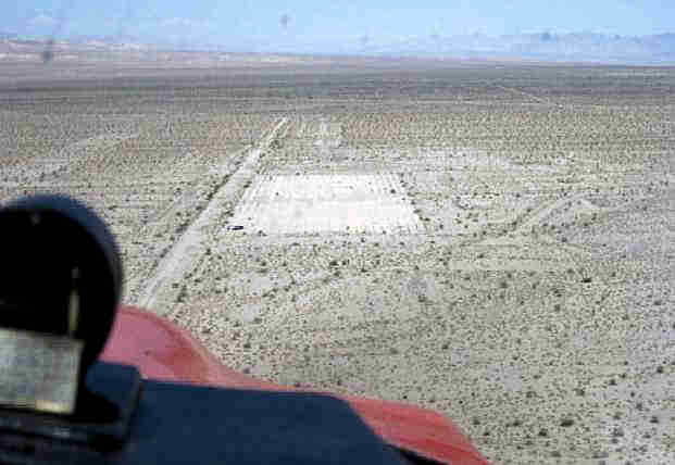
A June 2009 aerial view by Woodrow Anselen (enhanced by Bill Grasha) looking west on final approach to the Rice AAF ramp.
Woodrow reported, “Rice AAF looks pretty much the same as it did in the 2003 pictures.
Although the large runways are clearly visible from altitude, as one descends right into their vicinity,
they tend to blend in with the surrounding desert.
Down very low, I observed that they were really in poor shape & covered with lots of desert scrub bushes.
I probably could have made a landing, but opted instead for a touchdown on the concrete pad at the northern portion of the base.
This is not an overly large landing area (probably under 1,000') but what debris were on it were easily missed.”
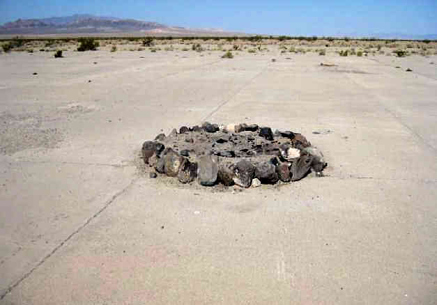
A June 2009 photo by Woodrow Anselen (enhanced by Bill Grasha) of a fire pit on the Rice AAF ramp.
Woodrow reported, “From what I could determine, this area has been used as some kind of makeshift campground as I saw several ad hoc fire pits.”
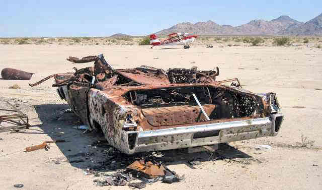
A June 2009 photo by Woodrow Anselen (enhanced by Bill Grasha) of the remains of a full-size 1965 Mercury on the Rice AAF ramp, with his Scout in the background.
Woodrow reported, “There is the remains of an automobile on this pad,
and over the years, some one has put an awful lot of bullet holes into it (I admit, I added 2 or 3 more),
and there are quite a bit of spent shell casings scattered about.”

A June 2009 photo by Woodrow Anselen (enhanced by Bill Grasha) of a foundation at the site of Rice AAF.
Jim Hottois reported in 2011, “Rice AAF / Rice Airport is slated to be the site of a very large solar energy plant which will completely use up the site.
The plant will use mirrors focusing sunlight on a large ball atop a several hundred foot high tower.
The sunlight will heat liquid salt which then will pass through heat exchanger to produce steam to run turbines.
It is an interesting technology because the liquid salt will hold its heat for 2-3 days.
The last I heard about it (last week), the project does not have all of the funding in place.”
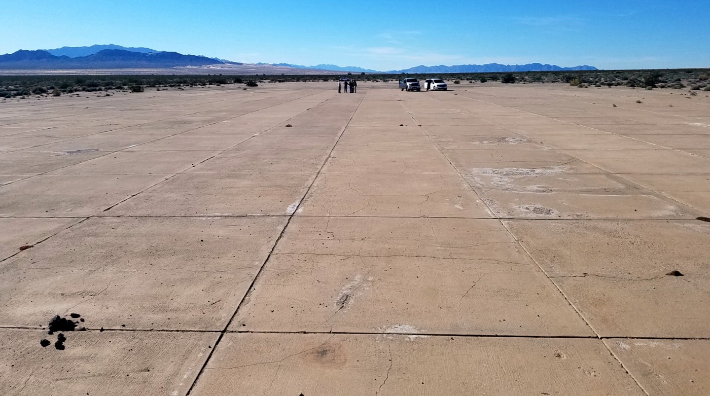
A 2/4/17 photo by Sean Eckstein of the Rice Airport tarmac.
Sean reported, “There still is an old car on the southwest corner, and some fire pits made from the local rocks at the east end.”
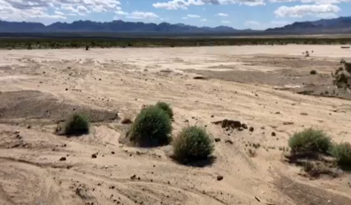
A still from a 3/23/20 video by Dick Welsh of the remains of Rice Airport.
Thanks to Mel Shettle for pointing out this airfield.
___________________________________________________
Harvey's Airport / Skyway Airport, Blythe, CA
33.61, -114.83 (West of Blythe Airport, CA)
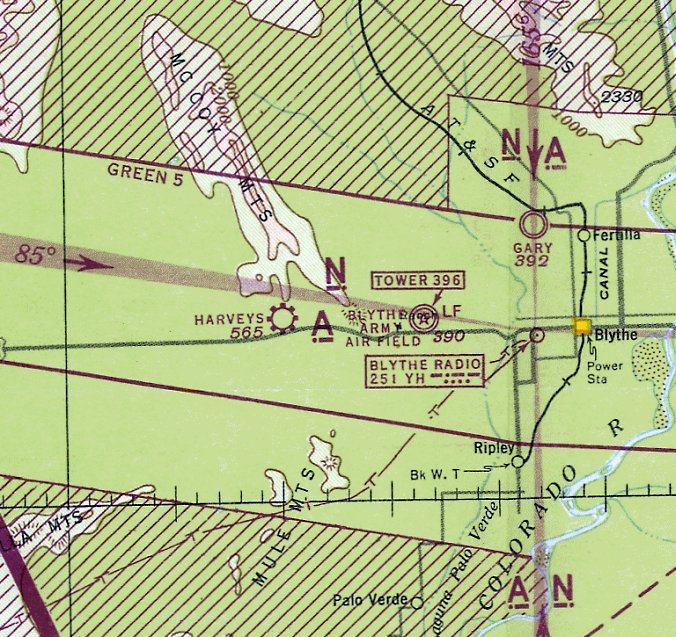
Harvey's Airport, as depicted on the August 1943 San Diego Sectional Chart.
According to Francis Blake, this small general aviation airport west of Blythe began operation in 1942.
The earliest aeronautical chart depiction which has been located of Harvey Airport was on the August 1943 San Diego Sectional Chart.
It depicted Harvey's as a commercial/municipal airport.
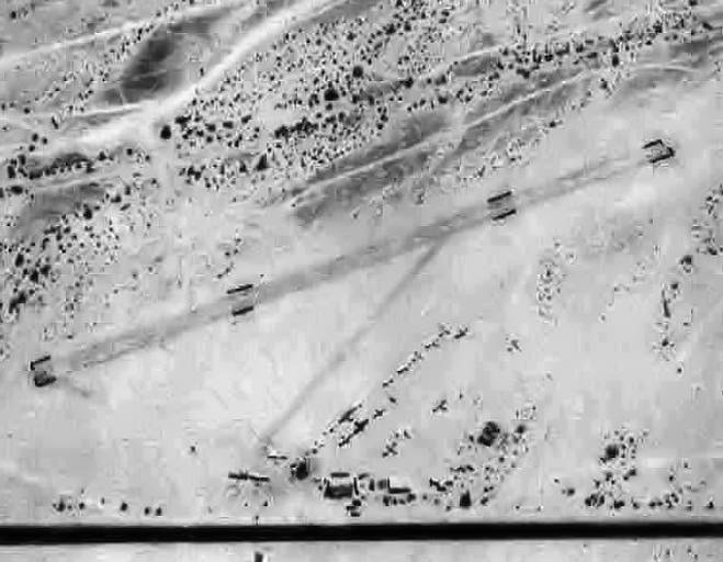
The earliest photo which has been located of Harvey Airport
was a 7/16/43 aerial view looking north from the 1945 AAF Airfield Directory (courtesy of Scott Murdock).
It depicted Harvey as having 1 unpaved northeast/southwest runway,
with possibly a gathering of small aircraft parked on the south side.
Francis Blake remarked, “I sure wonder why Harvey even bothered because Blythe had Gary Field & Heron Airport.
But Harvey's was certainly convenient to Highway 60, the main east/west road of the region.
He couldn't go any farther west since civilian aircraft (except airliners) were forbidden within 150 miles of the west coast.
And poor future planning about the Blythe Army Air Base becoming a civilian airport post-war.”
The 1945 AAF Airfield Directory (courtesy of Scott Murdock) described Harvey Airport
as a 160 acre rectangular property having 2 bare runways, measuring 2,300' northeast/southwest & 1,500' northwest/southeast.
The field was said to have 3 wood hangars, the largest measuring 40' x 30', and to be owned & operated by private interests.
According to “Events in the Palo Verde Valley in 1945” in the 4/14/11 Palo Verde Valley Times (courtesy of Francis Blake),
“Harvey's Airport, a civilian flying field 14 miles west of Blythe on U.S. Highway 60-70,
has been sold by its original developer, Harvey Reynolds of Covina & Blythe, to Mr. & Mrs. Edward Heard of this city.
The Heards have been operating the field for the past 2 years.
The property consists of 100 acres of land adjacent to the highway, 2 landing strips, hangars, a control tower, service station, store building & lesser structures.
The field has been used for student instruction & general civilian flying.
The Heards plan extensive expansions & improvements as soon as wartime building restrictions are lifted. The price paid was not divulged.”
The December 1948 San Diego Sectional Chart depicted Harvey as a commercial/municipal airport.
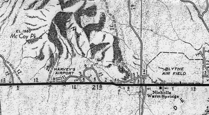
A 1951 map of Riverside County (courtesy of Francis Blake)
depicted Harvey's Airport as a small rectangular outline squeezed between Route 60/70 & McCoy Mountain.
Harvey's Airport was not depicted at all on the 1952 USGS topo map.
Harvey Airport was evidently renamed at some point between 1951-54 (presumably after it was sold),
as the March 1954 San Diego Sectional Chart labeled it as Skyway Airport, with an 1,800' unpaved runway.
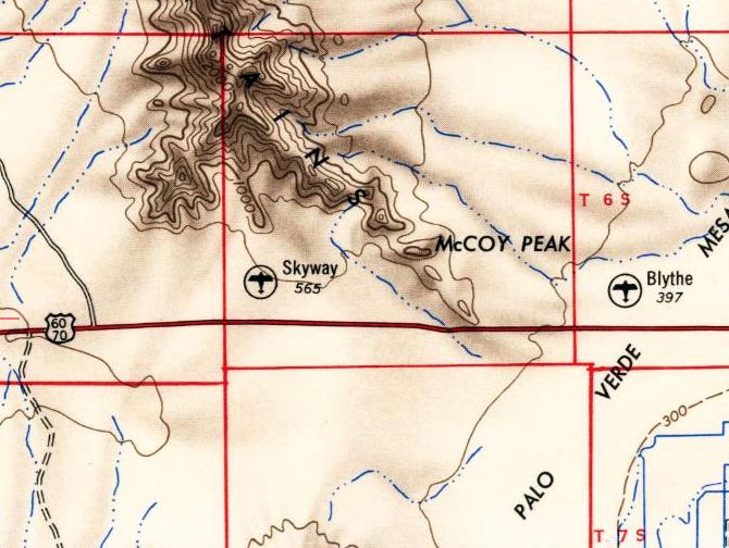
Harvey Airport was evidently renamed at some point between 1951-54 (presumably after it was sold),
as the 1954 USGS topo map labeled it as Skyway Airport.
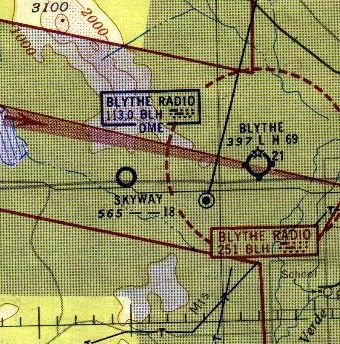
The last aeronautical chart depiction which has been located of Skyway Airport was on the 1955 San Diego Sectional Chart,
which depicted Skyway as having an 1,800' unpaved runway.
Skyway Airport was evidently closed at some point between 1955-65,
as it was no longer depicted on the August 1965 San Diego Sectional Aeronautical Chart (courtesy of Ron Kunse).
Skyway Airport was still depicted on the 1965 USGS topo map,
but was no longer depicted on the 1983 USGS topo map.
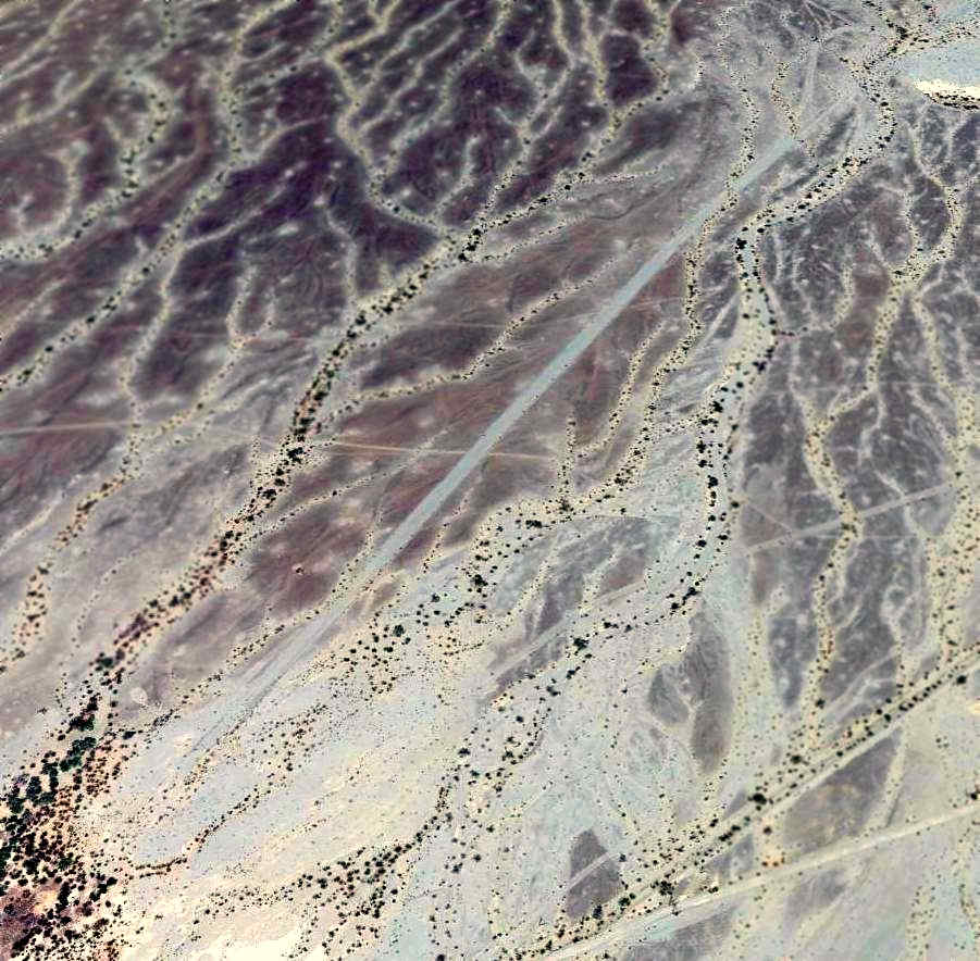
A 2014 aerial view (enhanced by Bill Grasha) looking northeast shows the Harvey/Skyway runway remarkably remains intact & recognizable.
The site of Harvey's Airport is located on the north side of Interstate 10, 7 miles west of Blythe Airport.
Thanks to Francis Blake for pointing out this airfield.
____________________________________________________
Eagle Mountain Pumping Station Airfield, Eagle Mountain, CA
33.8, -115.45 (East of Los Angeles, CA)
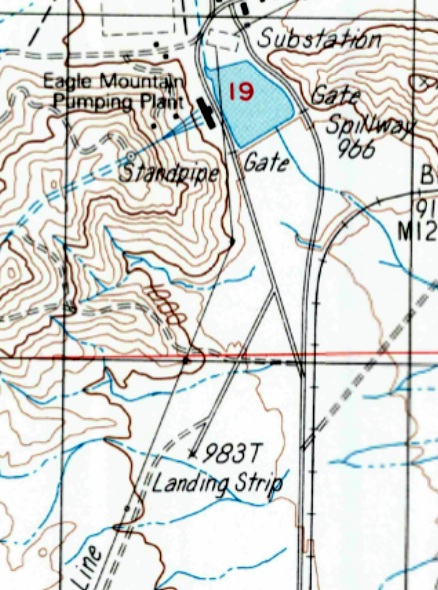
Eagle Mountain Pumping Station Airfield, as depicted on the 1987 USGS topo map.
Photo of the airport while open has not been located.
Not much is known about this airfield, including its name, date of construction, or purpose.
The adjacent Eagle Mountain Pumping Station is part of the Metropolitan Water District,
and appears on topo maps as far back as 1956.
The Eagle Mountain Pumping Station Airfield was evidently established at some point between 1972-87,
as it was not yet depicted on the 1972 USGS topo map.
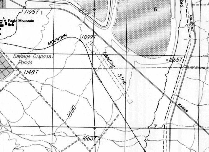
The earliest depiction of Eagle Mountain Pumping Station Airfield which has been located was on the 1987 USGS topo map,
which depicted a single northwest/southeast runway, labeled simply as “Landing Strip”.

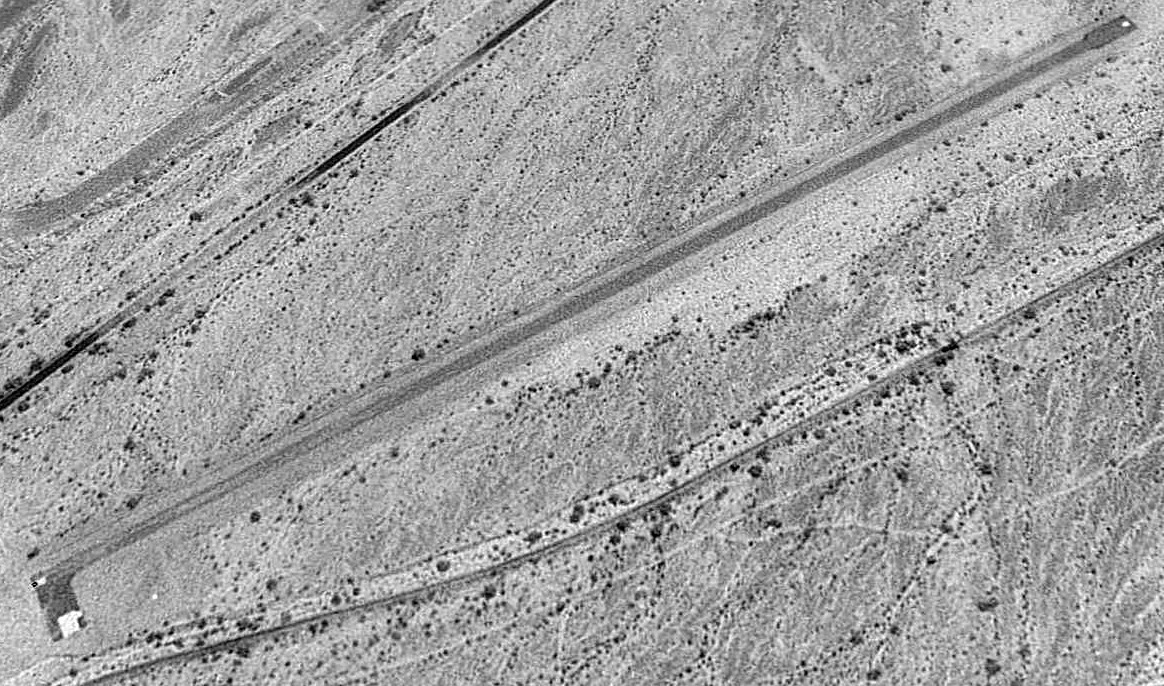
The earliest photo which has been located of the Eagle Mountain Pumping Station Airfield was a 5/20/94 USGS aerial view looking west.
It depicted the field as having a single paved runway marked with an “R” (denoting a private field) on the northwest end.
There did not appear to be any buildings or other improvements at the airfield.
As of 2014, the Los Angeles Sectional Chart does not depict any airfield at this location, not even an abandoned airfield.
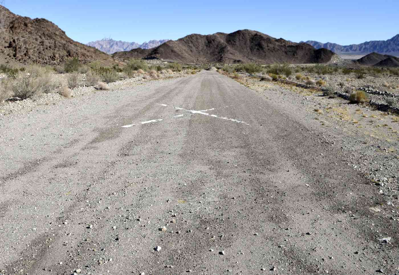
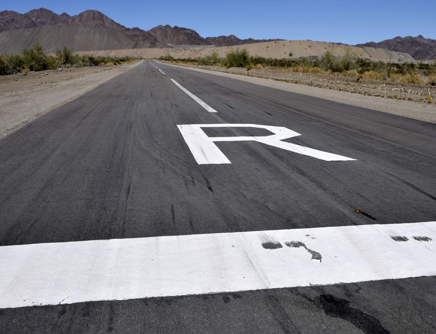
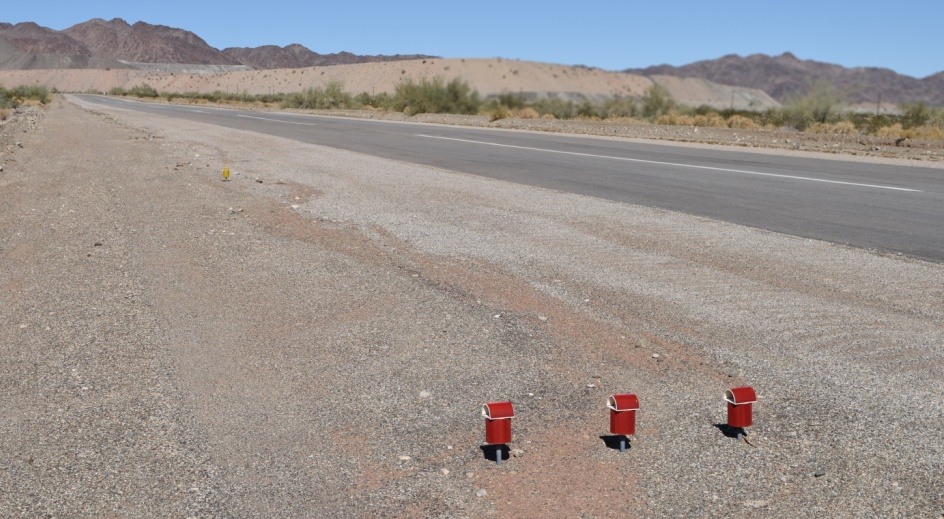
A 10/31/15 photo by Kurtis Clark looking north along the Eagle Mountain Pumping Station runway.
Kurtis reported, “The runway is not in bad shape, except for the piles of asphalt near the north end.”
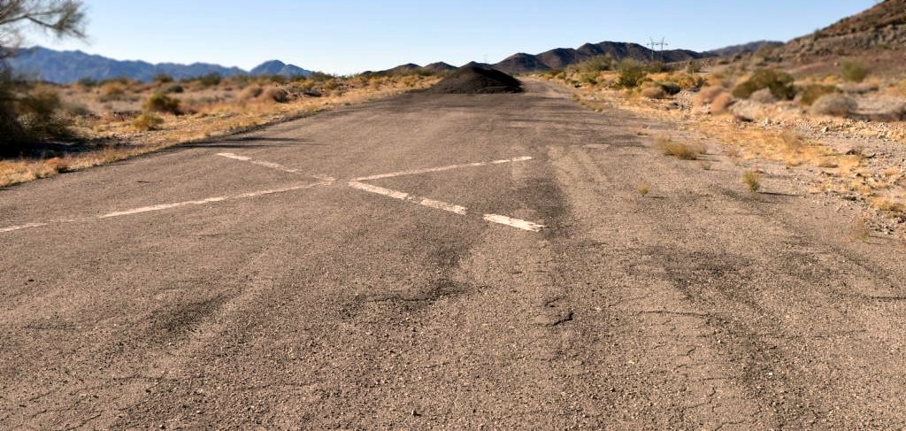
A 10/31/15 photo by Kurtis Clark looking south along the Eagle Mountain Pumping Station runway.
A 10/31/15 photo by Kurtis Clark of the aircraft parking chains which remain at the Eagle Mountain Pumping Station Airfield.
Kurtis reported, “There was a taxiway leading all the way to the pump house, complete with a tie-down area with 3 chains.”
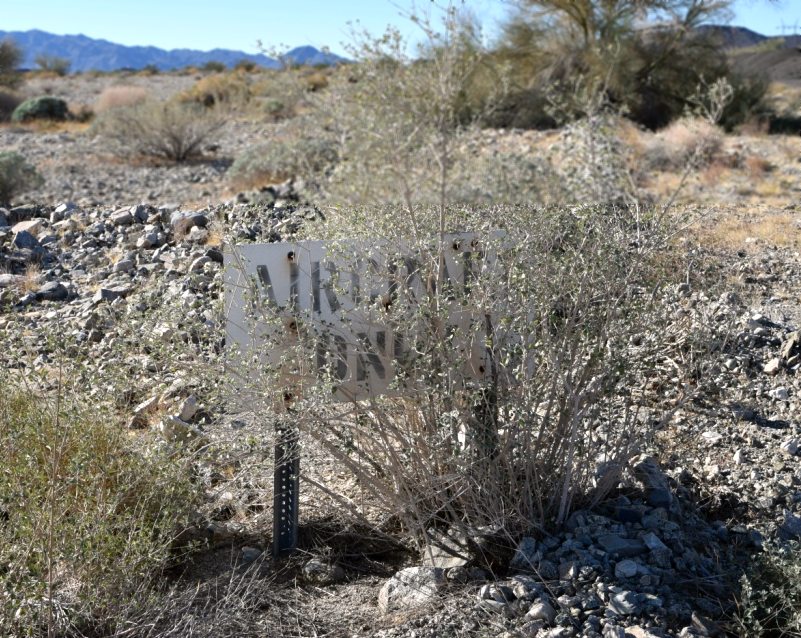
A 10/31/15 photo by Kurtis Clark of the “Aircraft Only” sign which remains at the Eagle Mountain Pumping Station Airfield.

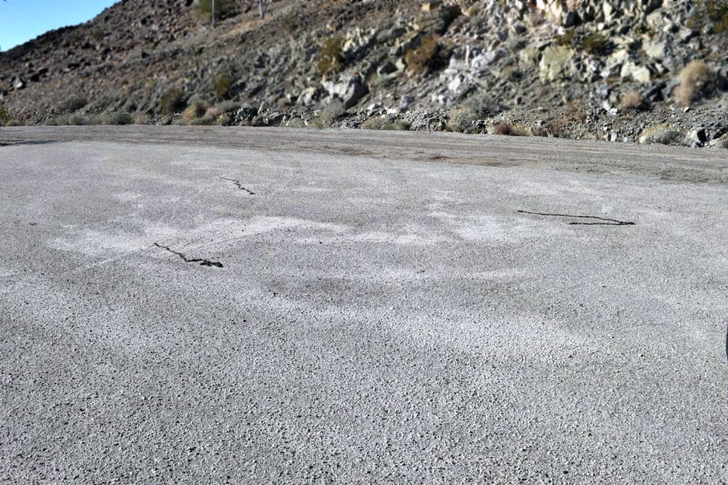
A 2023 aerial view looking west showed the Eagle Mountain Pumping Station runway to be considerably deteriorated, with the 2 previous closed-runway “X” symbols no longer discernible.
Eagle Mountain Pumping Station Airfield is located southwest of the intersection of Eagle Mountain Road & Power Line Road.
____________________________________________________
Eagle Mountain Airfield / Metropolitan Water District Airstrip, Eagle Mountain, CA
33.84, -115.46 (East of Los Angeles, CA)
Eagle Mountain Airfield, as depicted on the 1987 USGS topo map.
Photo of the airport while open has not been located.
The town of Eagle Mountain was founded in 1948 by industrialist & tycoon Henry Kaiser, to support his adjacent Eagle Mountain iron mine.
As the mine expanded, Eagle Mountain grew to a peak population of 4,000.
It had wide, landscaped streets lined with over 400 homes, some with as many as 4 bedrooms.
Another 200 trailer spaces & several boarding houses & dormitories provided living space for Kaiser's itinerant workforce.
Other amenities included an auditorium, a park, a shopping center, a community swimming pool, lighted tennis courts, a baseball diamond,
bowling alley, 2 gas stations, 8 churches and 3 schools.
No airfield was yet depicted at this location on the 1972 USGS topo map.
Increased environmental concerns in the 1970s led to a reduction in iron output & a drop in population to a low of 1,890.
In the summer of 1980 the mine shut down briefly, reopening later that year with a reduced workforce.
On 11/3/81 Kaiser Corporation announced the phasing out of the Eagle Mountain Mine operation over several years.
The Eagle Mountain Airfield was evidently established at some point between 1972-84,
as a 1984 aerial photo depicted a single northwest/southeast runway, with a small ramp on the northwest side.
The earliest map depiction which has been located of Eagle Mountain Airfield was on the 1987 USGS topo map,
which depicted a single 3,200' unpaved northwest/southeast runway, labeled simply as “Landing Strip”.
Eagle Mountain experienced a resurgence in 1986 when the California Department of Corrections
proposed placing a unique privately operated prison for low-risk inmates in the town.
The shopping center was converted by 1988 into the Eagle Mountain Community Correctional Facility.
Starting in 1988 a long-running effort began to turn the gigantic open-pit mine into a massive, high-tech sanitary landfill.
According to Wikimapia, this airfield is named the Metropolitan Water District Airstrip & was granted under a fee right-of-way in 1990.
A 5/20/94 USGS aerial view looking east depicted Eagle Mountain as having a single paved runway with a small paved ramp at the northwest end.
The runway was marked with a single “R” (denoting a private field) on the northwest end. There did not appear to be any buildings at the airfield.
A 2002 aerial view showed the Eagle Mountain runway to remain intact though deteriorated.
The adjacent Eagle Mountain Community Correctional Facility operated until state budget problems & a fatal riot led to the closing of the prison in December 2003.
A 2005 aerial view showed the Eagle Mountain runway had been repaved with asphalt at some point between 2005-2009.
According to a 2008 report by the Eagle Crest Energy Company, the Eagle Mountain Airfield was owned by Kaiser Industries.
As of 2009, the project to turn the Eagle Mountain mine into a landfill had not yet begun.
As of 2014, the Los Angeles Sectional Chart does not depict any airfield at this location, not even an abandoned airfield.
A 10/31/15 photo by Kurtis Clark looking north along the Eagle Mountain runway.
Kurtis reported, “I spoke with the Metropolitan Water District.
The runway is theirs & is used to transport inspection crews to the pumping plants, and to take water samples to the lab in a timely manner.
A typical aircraft used would be a Beechcraft King Air. There are visible skid marks on the runway. It is in great shape.”
A 10/31/15 photo by Kurtis Clark looking northeast at Eagle Mountain Airfield's runway lights.
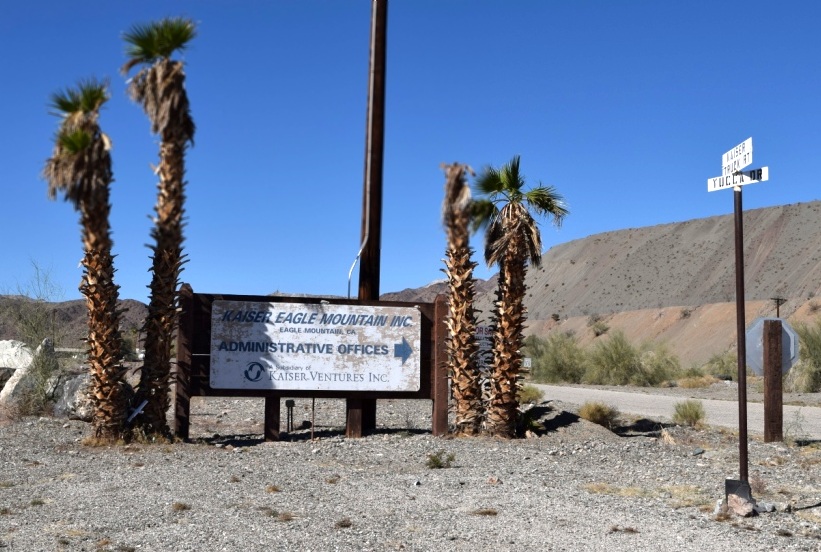
A 10/31/15 photo by Kurtis Clark of the Kaiser sign adjacent to the Eagle Mountain Airfield.
A 2016 aerial view looking east showed the Eagle Mountain runway to remain intact, with an “X” on the northwest end, and an “R” on the southeast end.
But there was still no sign of any recent aviation usage, nor any other improvements.
Eagle Mountain Airfield is located southeast of the intersection of Kaiser Road & Yucca Road.
Thanks to Khadijah for pointing out this airfield.
____________________________________________________
33.85, -114.8 (East of Los Angeles, CA)
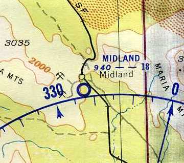
Midland Airfield, as depicted on the March 1952 San Diego Sectional Aeronautical Chart (courtesy of Chris Kennedy).
Photo of the airport while open has not been located.
According to Wikipedia, Midland was a company town established in 1925, owned by the U.S. Gypsum Company.
The company harvested vast amounts of gypsum found in the area, and the town had a population of approximately 1,000 at its peak.
Many winter scenes in Hollywood films during the 20th century utilized faux snow that originated from Midland.
The Midland Airfield was evidently established at some point between 1945-52,
as it was not yet depicted on the 1945 USGS topo map.
The earliest depiction of Midland Airfield which has been located
was on the March 1952 San Diego Sectional Aeronautical Chart (courtesy of Chris Kennedy).
It depicted Midland having an 1,800' runway.
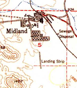
The 1952 USGS topo map depicted Midland Airport as having a single north/south runway, labeled simply as “Landing Strip”.
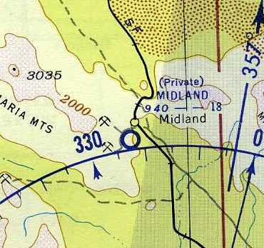
The March 1955 San Diego Sectional Aeronautical Chart (courtesy of Chris Kennedy)
depicted Midland as a private field having an 1,800' unpaved runway.
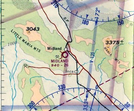
The last aeronautical chart depiction which has been located of Midland Airfield was on the August 1965 San Diego Sectional Aeronautical Chart (courtesy of Ron Kunse).
It depicted Midland as a public-use airport having a 2,600' unpaved runway.
According to Wikipedia, “As the character of the gypsum found in the area was considered too heavy as the years went on,
company activity in Midland subsided & then ended in 1966.”
A majority of the buildings of Midland were torn down by the company, leaving only foundations.
Midland Airfield had evidently gained a longer northwest/southeast runway at some point between 1955-81,
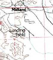
as the 1981 USGS topo map depicted the field as having 2 runways, labeled simply as “Landing Field”.
The earliest photo which has been located of Midland Airfield was a 6/15/96 USGS aerial view looking north, which depicted Midland as having 2 unpaved runways.
There was no sign of the airfield having had any buildings.
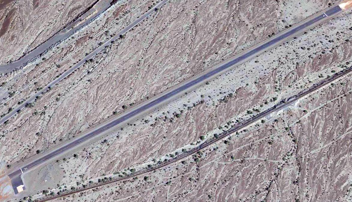
The last photo which has been located of Midland Airfield was a 6/18/10 aerial view looking north, which depicted Midland as having 2 unpaved runways.
The site of Midland Airfield is located at the southern terminus of Midland Depot Road.
Thanks to Gary Alexander for pointing out this airfield.
____________________________________________________
33.61, -114.57 (North of Yuma, AZ)
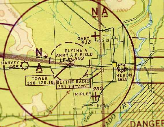
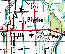
Heron Airport, as depicted on the August 1945 San Diego Sectional Aeronautical Chart (courtesy of Chris Kennedy).
Heron Airport was apparently the pre-WW2 civil airport for the town of Blythe.
Its date of construction is unknown.
The Standard Oil Company's 1929 "Airplane Landing Fields of the Pacific West" (courtesy of Chris Kennedy)
described a "Blythe Municipal" Airport as being located 3/4 mile east of Blythe, which would correspond to the location eventually occupied by Heron Airport.
It had a 3,000' loamy soil runway, oriented southwest/northeast.
The 1944 US Army/Navy Directory of Airfields (courtesy of Ken Mercer) described Heron Airport as having a 2,700' runway.
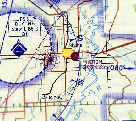
The earliest depiction of Heron Airport which has been located was on the August 1945 San Diego Sectional Aeronautical Chart (courtesy of Chris Kennedy).
It depicted Heron as a commercial/municipal airport.
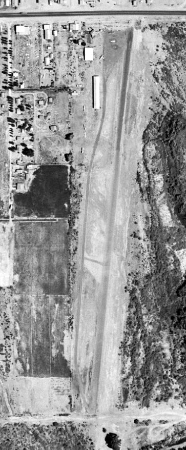
The earliest photo which has been located showing Heron Airport in operation was a 6/11/48 USGS aerial view.
It depicted Heron Airport as having a single north/south runway, with several small buildings & 6 single-engine aircraft on the northwest side.
Heron Airport was described on the 1949 Gila River World Aeronautical Chart (courtesy of Donald Felton) as having a 2,600' unpaved runway.
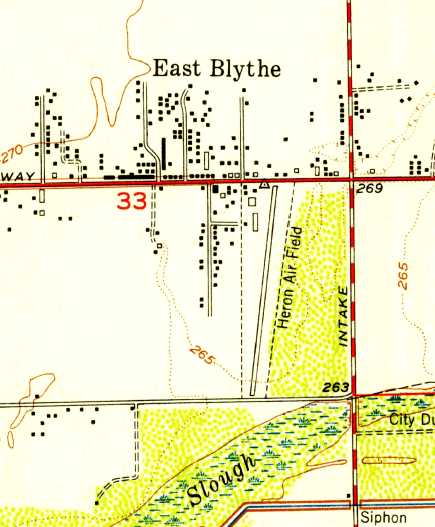
The 1951 USGS topo map depicted “Heron Air Field” as having a single north/south runway, with several small buildings on the northwest side.
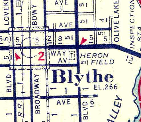
A 1954 AAA map of Riverside County (courtesy of Chris Kennedy)
depicted “Heron Field” as a square parcel of land, west of Intake Boulevard & north of 14th Avenue.
Fred Grande recalled, “I flew out of Heron field in a J3 Cub - I think it was 1953 -
taking a plane from there to an old dirt strip that the crop dusters used on the west side of the Valley.”
The runway at Heron was apparently paved at some point between 1949-55,
as the "Aerodromes" table on the 1955 San Diego Sectional Aeronautical Chart (courtesy of John Voss)
described the field as having a single 2,550' bituminous runway.
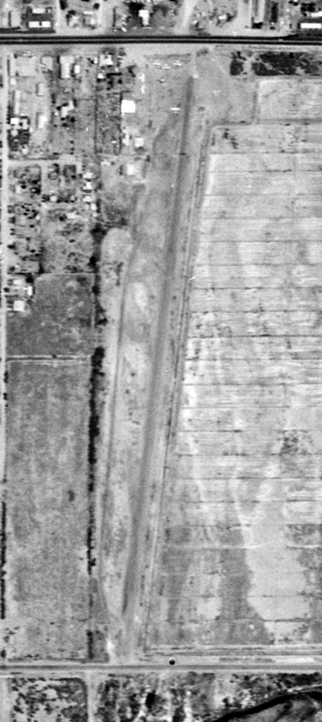
The last photo which has been located showing Heron Airport in operation was a 6/9/59 USGS aerial view.
It depicted Heron Airport as having a single north/south runway, with several small buildings & 6 single-engine aircraft on the northwest side.
In the 1962 AOPA Airport Directory, Heron Airport was described as having a single 2,550' bare Runway 18/36,
and the operator was listed as Leon Coromes.
The August 1967 San Diego Sectional Chart (courtesy of Chris Kennedy) depicted Heron Airport as having a single 2,500' north/south paved runway.
The NTSB report for a 4/16/67 accident in which a Luscombe 8A ended up substantially damaged after performing a ground loop at Heron Airport
described the field as having a 25' wide oiled runway.
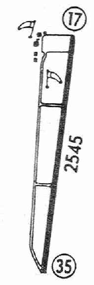
The last authoritative depiction of Heron Airport as an active airfield which has been located was in the 1968 Flight Guide (courtesy of Chris Kennedy).
It depicted Heron as having a single 2,545' paved Runway 17/35.
A parallel taxiway on the west side ran to a ramp on the northwest corner of the field, around which were clustered several small buildings.
Heron Airport was still depicted on the 1969 USGS topo map.
Raymond Mendoza recalled, “Heron Airport closed when I-10 was built through Blythe, this would be about 1969-1970.
I was born in 1965 in Blythe, and remember the freeway construction going on around the time I was 4-5 years old.
I do remember the runway being paved, and what was left on the south side of I-10 was used for storing hay much of the time.
The part on the north side of the freeway was never used for anything. The hangar became an automotive repair place.”
Heron Airport was no longer depicted at all on the 1975 USGS topo map.
The 1975 map showed that Interstate 10 had been constructed through the center of the former airport.
The 2002 USGS aerial photo showed that the site of the former Heron Airport had been bisected by Interstate 10.
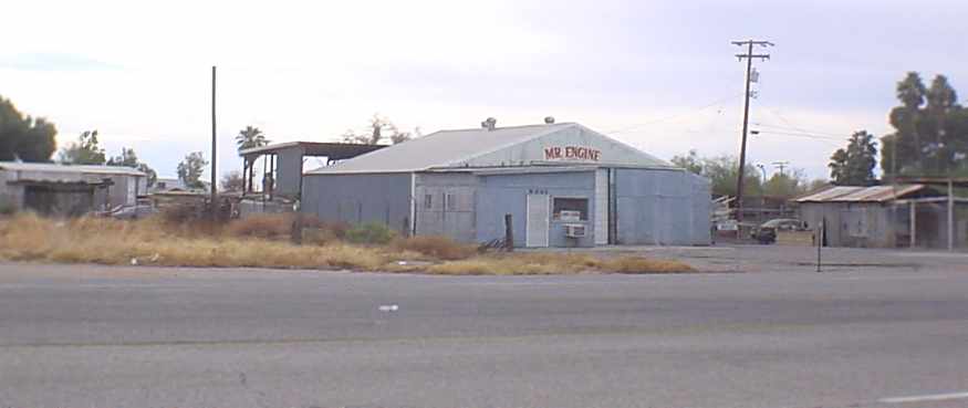
A 2006 photo by Raymond Mendoza, looking south from Hobson Way at what appears to be a former Heron Airport hangar, on the northwest corner of the site.
Raymond reported, “The hangar appears to still be in use.”
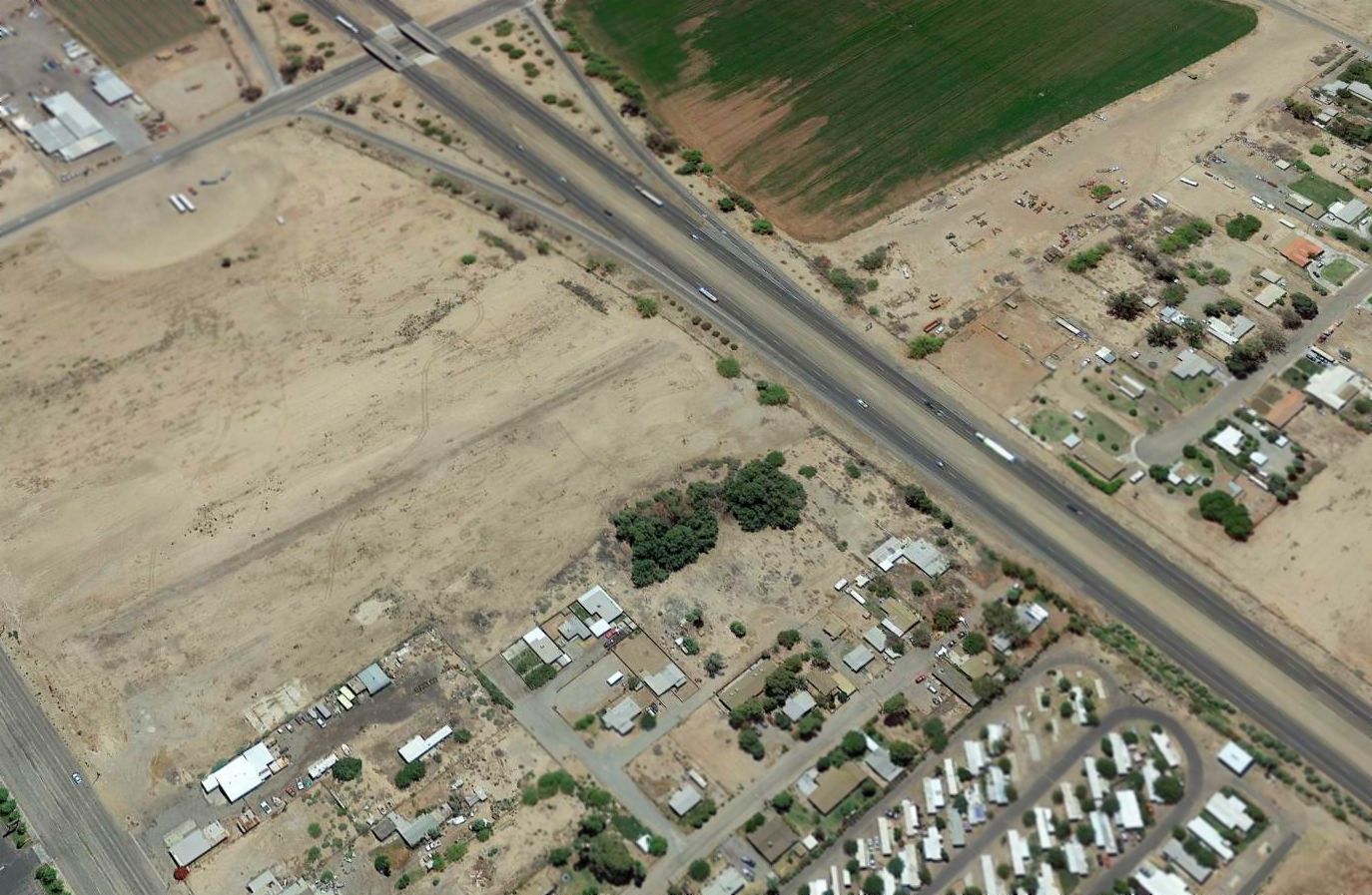
A 2014 aerial view looking southeast at the site of Heron Airport showed that the outline of the former Runway 17/35 was still visible both north & south of Interstate 10.
The former hangars are visible at bottom-left.
The Heron Airport site is located west of the intersection of Interstate 10 & Intake Boulevard.
____________________________________________________
Gary Field / W.R. Byron Airport (44CA), Blythe, CA
33.68, -114.64 (North of Yuma, AZ)
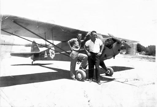
A 1942 photo of 2 unidentified Civil Air Patrol pilots in front of a CAP 1940 vintage BL-65 Taylorcraft at Gary Field.
Gary Field was the site of the Morton Air Academy, which provided contract primary flight training to the Army Air Corps during WW2.
The date of construction of Gary Field is unknown.
However, a 1944 class book from the Morton Air Academy (courtesy of Bob Alvis)
indicated that the first official training flight from Morton Air Academy took place on 6/30/42,
piloted by Aviation Cadet Gornik & Instructor Villagren.
The earliest photo which has been located of Gary Field was a 1942 photo of 2 unidentified Civil Air Patrol pilots in front of a CAP 1940 vintage BL-65 Taylorcraft.
Jim Garver reported, “Gary Field... My mom worked there as an accountant for a civilian army training operation in Blythe.
I think she worked there about a year during the war years. They were lodged in trailers there, which was very hot, so she didn't stay.
She told me that movie stars would bring their girlfriends out there to go flying, as Blythe was just beyond the 200 mile no-fly limit from the coast.
She dated the instructors, who taught her how to fly & let her take a Taylorcraft up by herself, although she did not have the medical documents for that.”
Gary Field was not yet depicted on the October 1942 San Diego Sectional Chart.
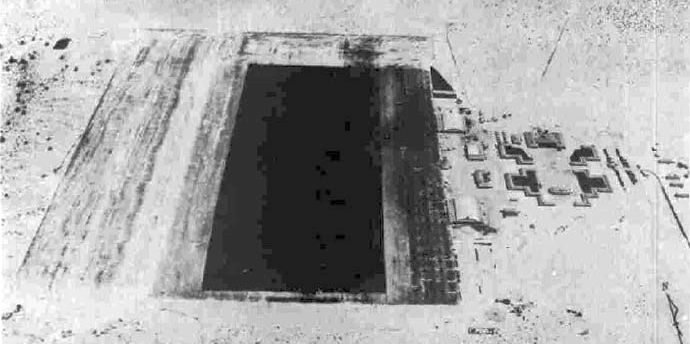
A 7/16/43 aerial view looking north at Gary Field from the 1945 AAF Airfield Directory (courtesy of Scott Murdock).
In the school's first 2 years over 265,000 hours had been flown,
and 3,750,000 gallons of gasoline were consumed by the school's Ryan & Stearman training planes.
A WW2-era aerial view of Gary Field,
from the cover of a 1944 class book from the Morton Air Academy (courtesy of Bob Alvis, enhanced by Bill Grasha).
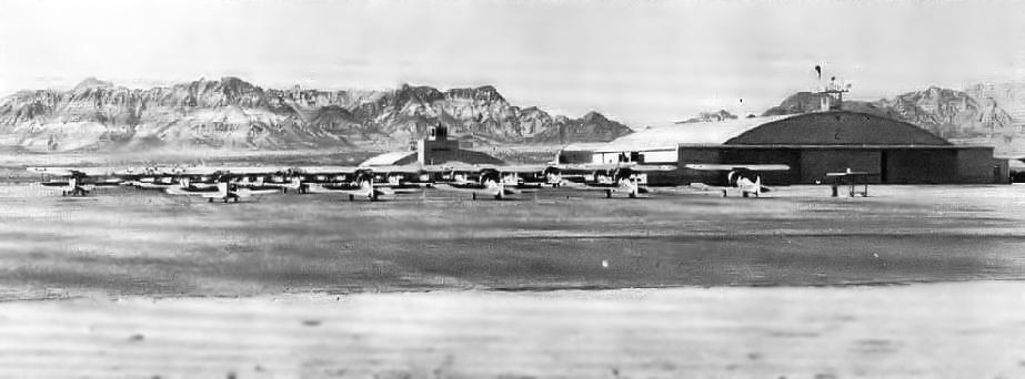
A view looking north along the landing mat at Gary Field,
from a 1944 class book from the Morton Air Academy (courtesy of Bob Alvis, enhanced by Bill Grasha).
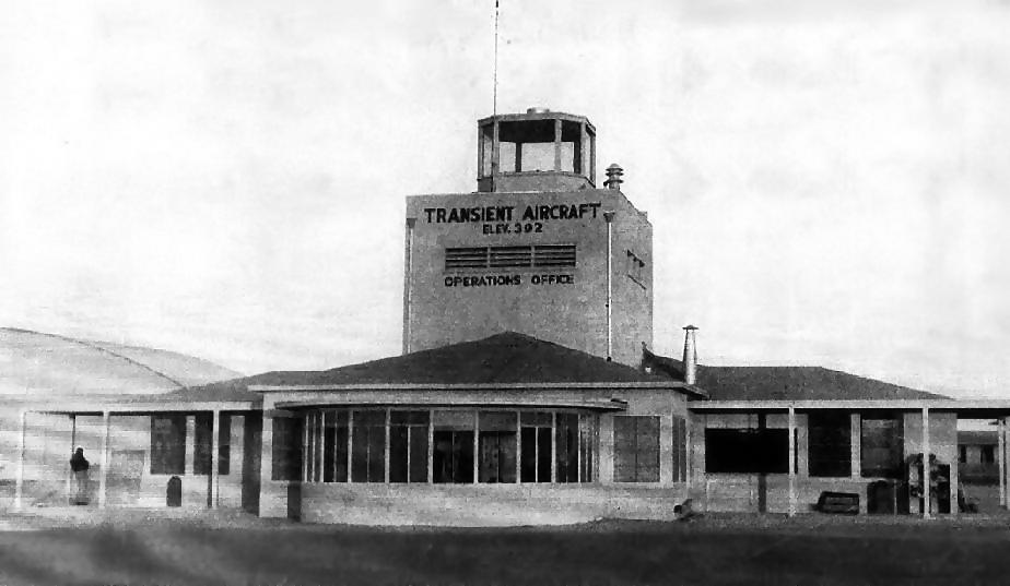
A WW2-era view of Gary Field's control tower & operations office,
from a 1944 class book from the Morton Air Academy (courtesy of Bob Alvis, enhanced by Bill Grasha).
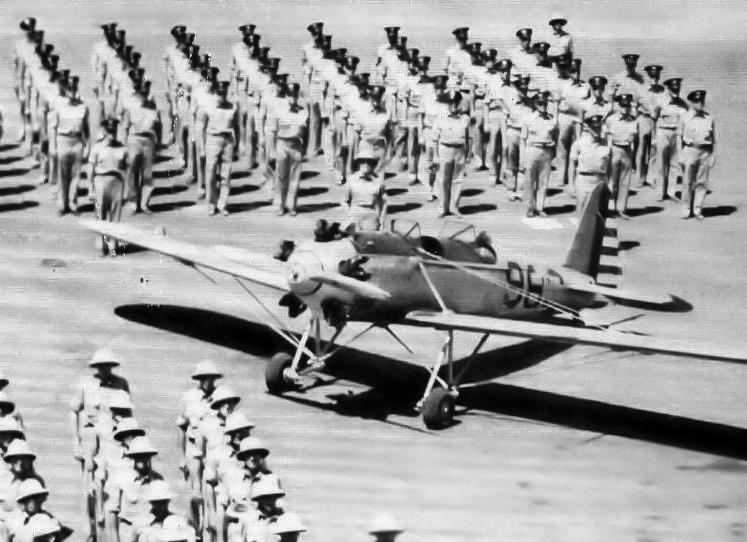
A WW2 era photo of a Ryan PT-22 & cadets at Gary Field,
from a 1944 class book from the Morton Air Academy (courtesy of Bob Alvis, enhanced by Bill Grasha).
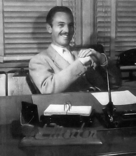
A WW2 era photo of Ted Morton, the president of the Morton Air Academy,
from a 1944 class book from the Morton Air Academy (courtesy of Bob Alvis, enhanced by Bill Grasha).
The President of Morton Air Academy was Ted Morton, who learned to fly in 1925.
After establishing a flying service in Los Angeles,
Morton was among the first to receive a contract by the military to operate a Civilian Pilot Training School.
The General Manager of the Morton Air Academy was Fred Falkin. Gary Field was named for his son Gary.
David Falkin reported, “My dad is the one the airfield was named after, Gary wesley Falkin.”
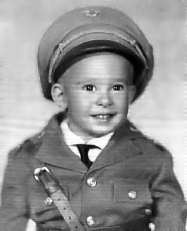
Gary Falkin, as depicted in a photo from a WW2 class book from the Morton Air Academy (courtesy of Bob Alvis, enhanced by Bill Grasha).
"Gary Field of young Master Gary Falkin.
He symbolizes the youth & undeniable future of aviation & the splendid record established at Gary Field gives him a proud heritage to fulfill."
The Wing Commander at the Morton Air Academy was Roger Pryor, Robert Driver was the Director of ground school,
and Tom Talbot was the Superintendent of Maintenance.
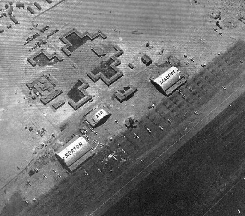
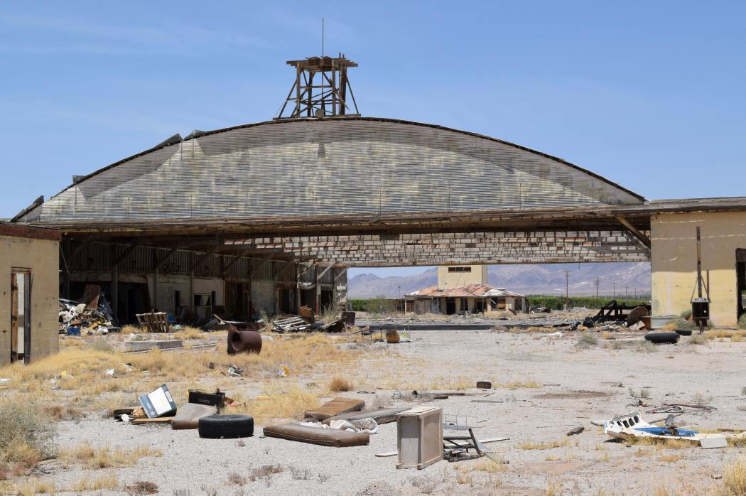
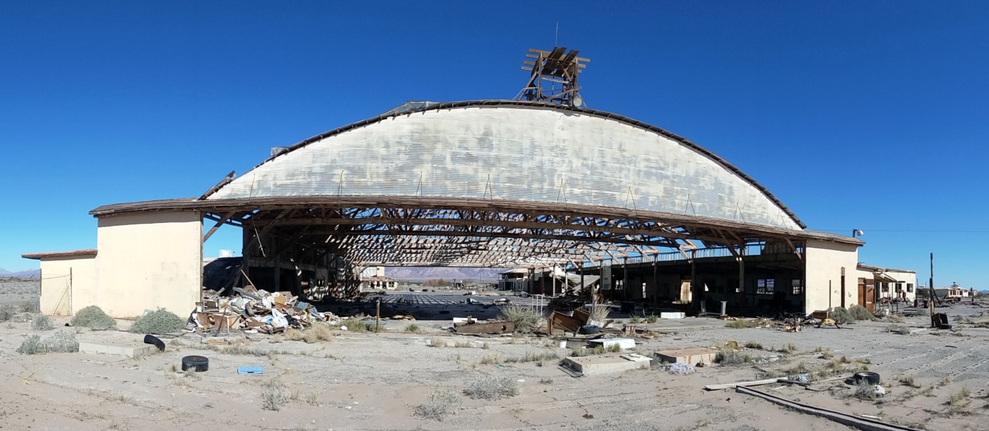
Gary Field had 2 large arch-roof hangars adjacent to the east side of the landing mat.
The northern large hangar was #1, while the southern hangar was marked #2.
An operations building with a control tower on top sat in between the 2 large hangars.
A smaller arch-roof hangar sat just northeast of the operations building, while the administration building sat the southeast.
The word "Morton" was painted on the roof of Hangar 1, "Air" was painted on the roof of the smaller hangar,
and "Academy" was painted on the roof of Hangar 2.
The Primary Flying School at Gary used the Stearman PT-17.
The contract flying schools were mostly staffed by civilian instructors.
The Commanding Officer was an AAF officer,
and usually there were AAF check pilots who made sure the students were qualified.
The Commander at Gary was Major Frank Fuller of the Fuller Paint Company fame.
The civilian head was Roger Pryor, who was a musical director for one of the Hollywood film studios.
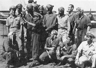
A WW2 era photo (courtesy of Rebecca Serignese, enhanced by Bill Grasha) of cadets at Morton Air Academy.
Rebecca Serignese reported that "My grandfather (James Ciampolillo) was an instructor at the Morton Air Academy during WW2.
My grandfather is the one in the center visually showing the cadets something with his hands."
The earliest aeronautical chart depiction which has been located of Gary Field was on the March 1944 San Diego Sectional Chart.
It depicted Gary as a commercial/municipal airport.
"Gary, Army" was listed in the 1944 US Army/Navy Directory of Airfields (courtesy of Ken Mercer).
It was described as having a 2,800' hard-surfaced runway.

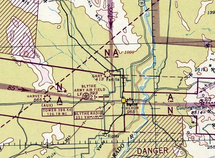
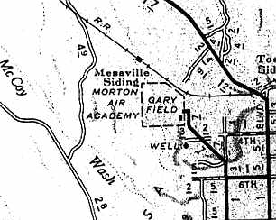
A 1944 map of Gary Field ("Blythe Primary Flying School" at the top) & its 3 auxiliary fields & other nearby airfields (courtesy of John Voss).
Gary Field had a total of 3 auxiliary airfields during WW2:
A-1 Ripley #1 (10 miles south), A-2 Ripley #2 (8 miles south), and A-4 (which was located a mere half mile to the west).
Apparently not a trace remains of Gary Field's 3 former auxiliary fields.
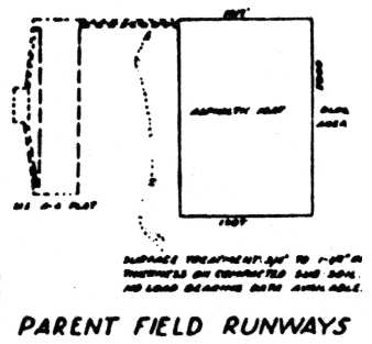
A 1944 diagram (courtesy of John Voss) of the airfield at Gary Field (on the right), and its auxiliary field A-4 (on the left).
As depicted on the diagram, the airfield at Gary Field consisted of a rectangular landing mat, measuring 3,000' x 2,000'.
The January 1945 AAF Airfield Directory (courtesy of Scott Murdock) described Gary Field
as a 720 acre irregularly-shaped property having an asphalt landing mat measuring 2,900' north/south by 2,700' east/west.
The field was said to have 2 wood & metal hangars, measuring 200' x 151',
and to be owned & operated by the Defense Plant Corporation.
The last aeronautical chart depiction which has been located of Gary Field was on the February 1947 San Diego Sectional Chart.
It depicted Gary as an auxiliary airfield.
The facilities of the former Morton Air Academy were reused in 1947 by the Palo Verde College,
and it was at this point that any aviation use of the airfield presumably ended.
Gary Field was no longer depicted on the August 1947 San Diego Sectional Chart.
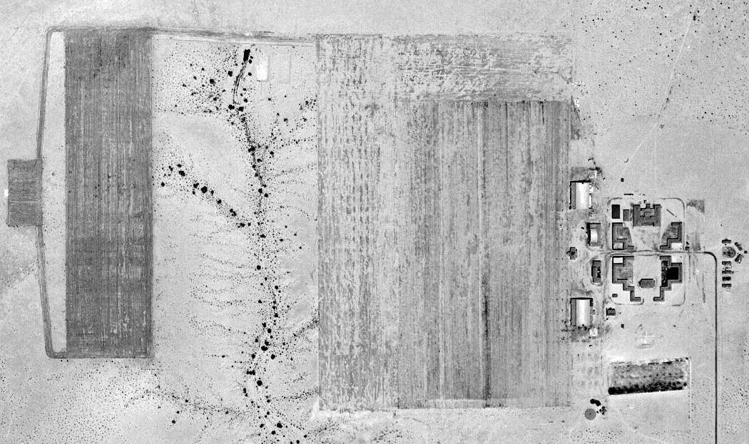
A 7/26/48 USGS aerial view depicted Gary Field (on the right) as well as its auxiliary field A-4 (the north/south asphalt airfield located a mere half-mile to the west).
However, Gary Field (& the Morton Air Academy) were still depicted on the 1951 USGS topo map (courtesy of Fran Blake).
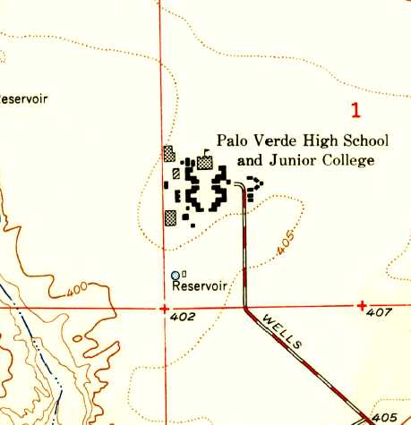
A closer-scale 1951 USGS topo map labeled the Gary Field buildings as “Palo Verde High School & Junior College”, but no longer depicted the airfield at all.
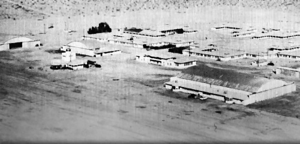
The last photo which has been located showing the facilities at Gary Field to remain completely intact was an undated aerial view looking north,
showing the facilities being reused as the Palo Verde High School, from the 1955 Palo Verde Annual (courtesy of Fred Grande, enhanced by Bill Grasha).
Fred observed, “It was taken before 1953 because when I was there, there were 15-20' tall cotton wood tree all around the parade grounds (quad) .
My sisters & I went to Gary Field (then called - Palo Verde High School). In fact I was in the last class going through – 1958.”
Palo Verde College continued to use the Gary Field facilities until 1958.
Gary Field was not depicted at all (even as an abandoned airfield) on the 1969 Sectional Chart.
Jim Hottois reported, “There were aircraft at Gary Field after the high school & college moved from there.
I suspect that the guy who told me about flying out of there was doing so in the 1970s.”
Amazingly though, after being abandoned as an airfield for at least 33 years, the site of Gary Field was reused as a private airfield.
According to the FAA Airport/Facility Directory, as of 1981 the site has been registered as a private airfield, "W.R. Byron Airport" (44CA).
It was listed as having a single 2,640' asphalt Runway 18/36, with one single-engine aircraft based on the field.
The owner was listed as Willard R. Byron.
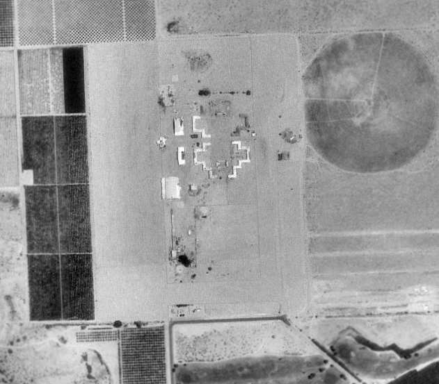
The 1994 USGS aerial photo showed that many of Gary Field's original hangars & buildings remained standing,
although the northern hangar had been removed at some point between 1953-94.
It did not show any indication of the use of the property as a private airfield.
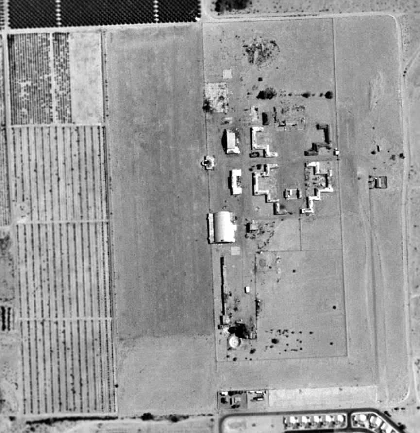
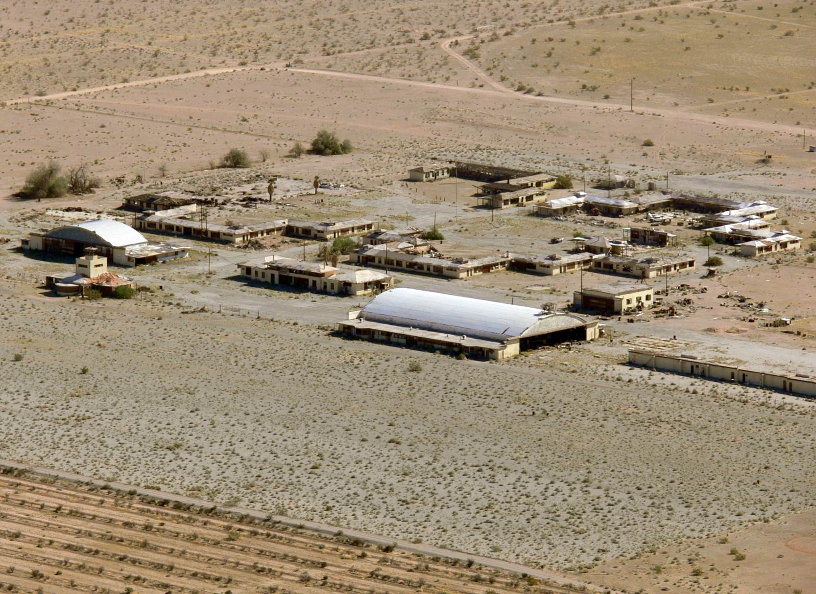
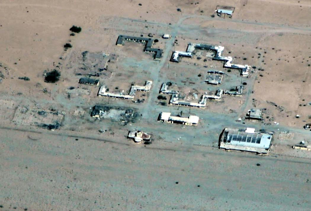
Amazingly, even though Gary Field has apparently been abandoned for some 50 years,
in the 2002 USGS aerial photo, many of the original hangars & buildings remain standing.
In particular, the characteristic irregular arrangement of the barracks buildings which remains at the site
make the location of Gary Field very much recognizable.
One of the large arch-roof hangars remains standing (at the southwest corner of the group of buildings),
as well as the tower/operations building (just north of the large hangar),
as well as one smaller hangar (northeast of the tower/operations building).
The second large hangar (at the northwest corner of the site) was apparently removed, but its foundation is still clearly recognizable.
A 2,500' long portion of the former runway area remains intact, adjacent to the west side of the buildings.
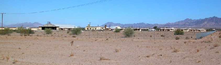
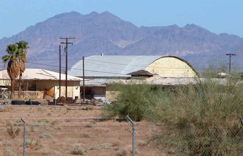
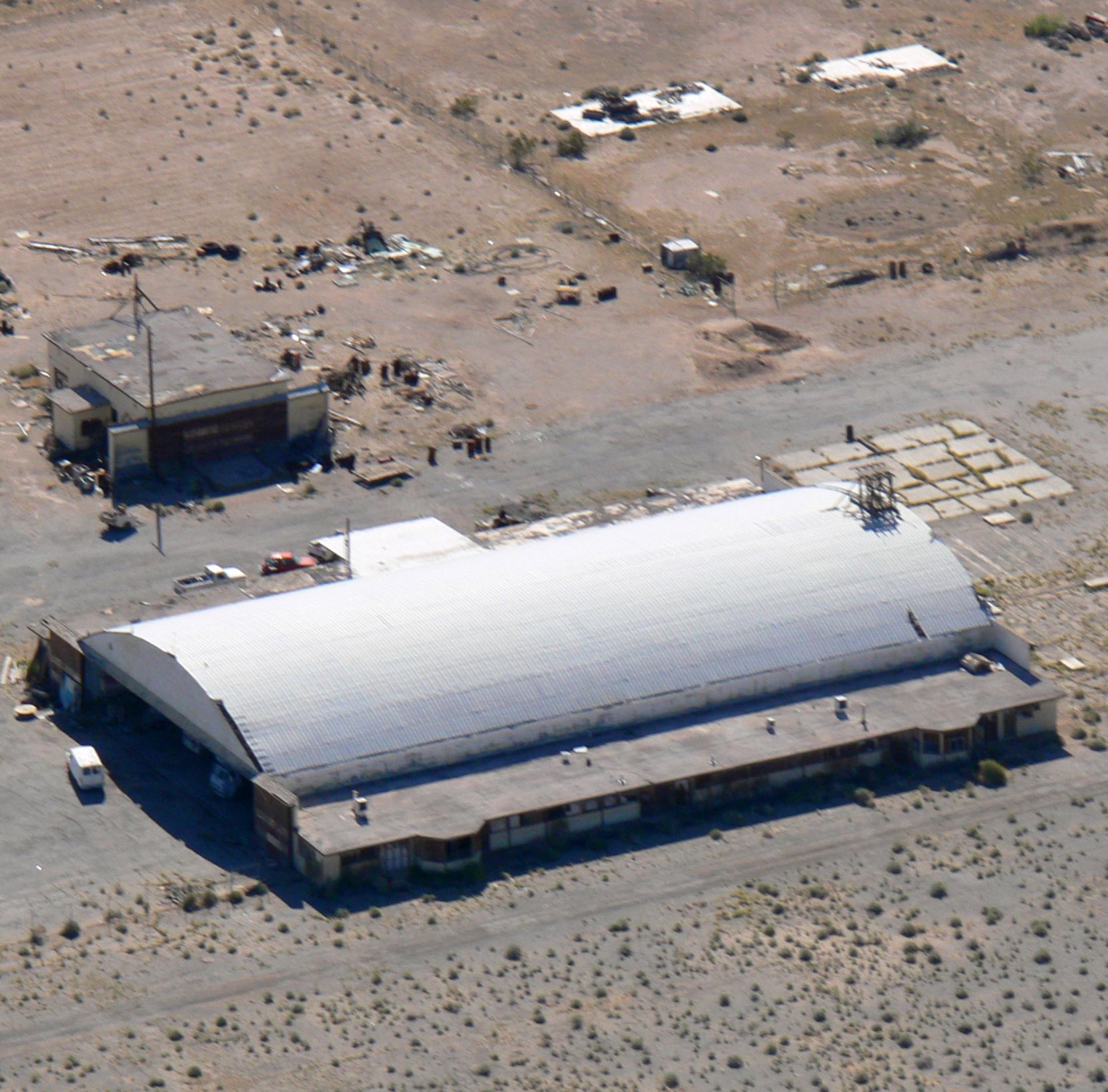
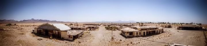
A September 2004 panorama by Chris Kennedy looking northwest at the almost completely intact buildings & hangars of Gary Field.
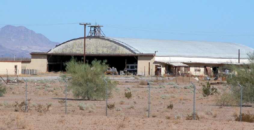
A September 2004 photo by Chris Kennedy looking northwest at the 60-year old south hangar which remains standing at Gary Field.
A September 2004 photo by Chris Kennedy looking northwest at middle hangar at of Gary Field.
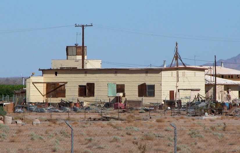
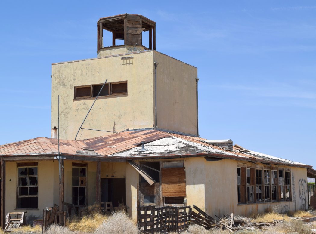
A September 2004 photo by Chris Kennedy looking northwest at the boarded-up control tower,
which remains standing on top of the former operations building.
Chris Kennedy visited the site of Gary Field in September 2004, and found that the site is remarkable well-preserved,
with most of the former airfield buildings & hangars still standing, and in quite good condition.
His report: "The Gary Field site is completely fenced off & marked 'Private' & 'No Trespassing'.
As you can see in the pictures, there are electric wires running into it & some evidence of use of some of the buildings.
I was surprised to find so much still intact."
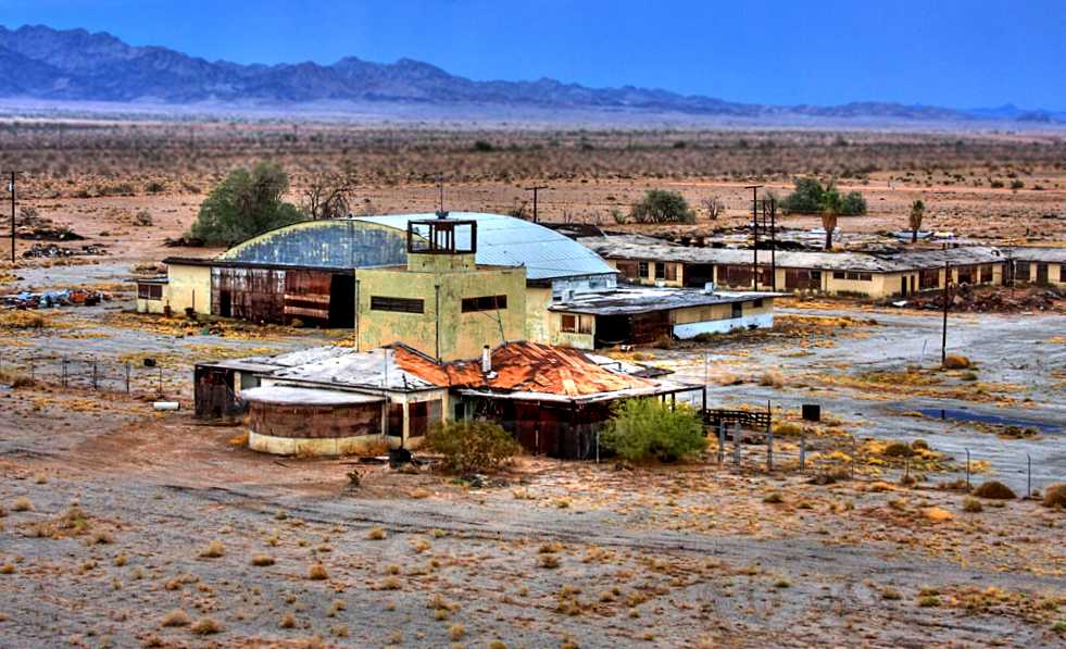
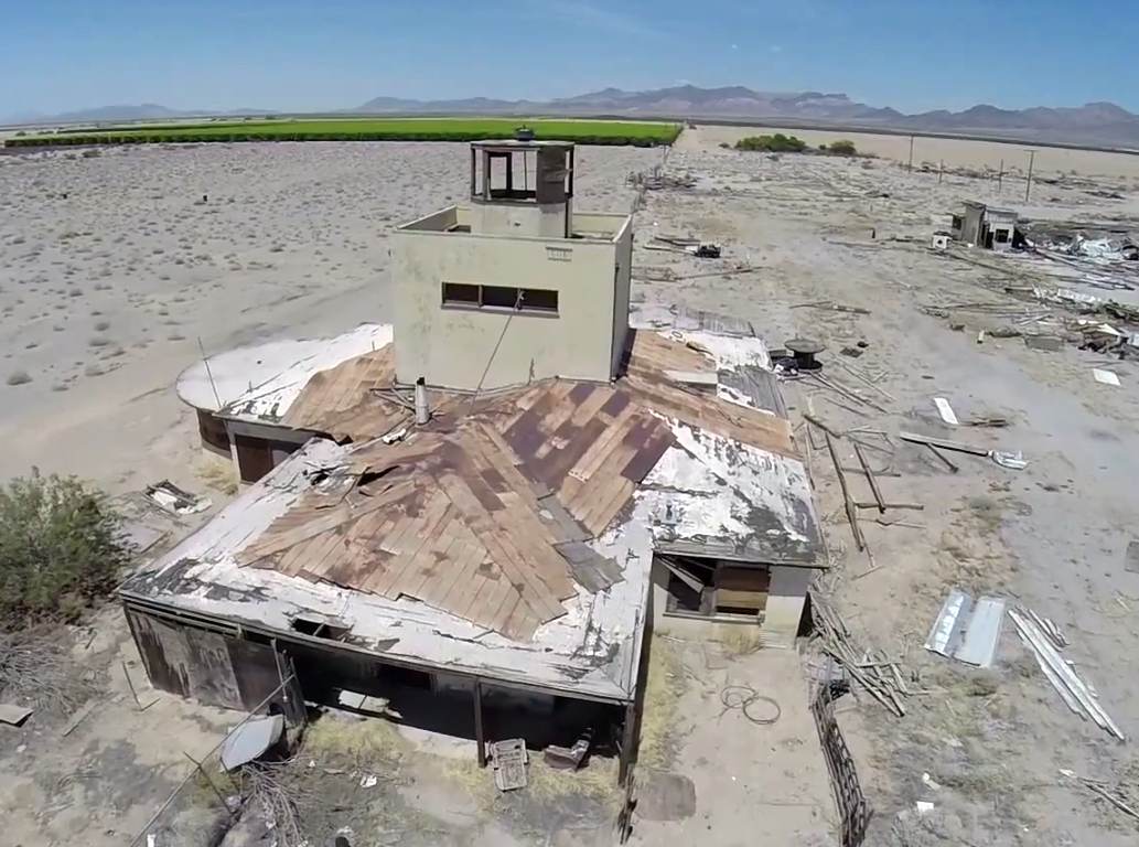
A July 2008 aerial view by Glen Haas (of Glen Haas Aerial Photography) looking northeast at the control tower & a hangar at Gary Field.
Glen observed, “I flew over the remnants of this field & was curious as to its origins.
The design of the main terminal & the layout of the other buildings/classrooms/hangers/etc was really quite interesting.
Given that Blythe is a miserably hot, barren place (especially 50 years ago) it amazed me this place existed.
What was more amazing was the size of the place. I flew over in a 1946 Cessna 120 so it seems fitting.”
A July 2008 aerial view by Glen Haas (of Glen Haas Aerial Photography) looking east at the remains of Gary Field.
As of 2009, the FAA Airport/Facility Directory still shows the site of Gary Field being used as a private airfield, "W.R. Byron Airport" (44CA).
In Keith Wood's words, "Nice to see one of the old ones get a new life."
Jim Hottois reported in 2011, “Gary Field was listed as a private airport when a developer bought it with the intent of developing an aviation-themed community on the property.
Everything apparently stopped when the housing boom turned to bust.
It must have been at least 3 years ago when I met with the folks who were planning to develop housing around Gary Field.
It was about the same time that the airport reappeared on the LA sectional.”
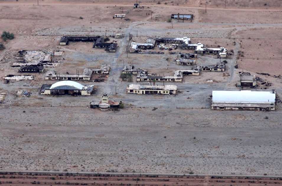
An April 2011 aerial view by Jaclyn Randall looking southeast at a former Gary Field hangar (courtesy of Jim Hottois).
Jim Hottois reported, “All of the vehicles in the photos are derelicts. I have never seen aircraft there. I have only lived here in Blythe 10.5 years.
It is too bad to see the buildings just sitting there. But, you know, it was built to be temporary and it has lasted more than 70 years.”
An April 2011 aerial view by Jaclyn Randall looking northeast at Gary Field (courtesy of Jim Hottois).
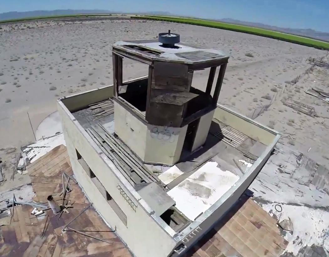
A sad 2012 photo by Travis Waters (enhanced by Bill Grasha) of the Gary Field control tower, still standing, but with the first-floor roof caving in.
Travis reported, “The place looks pretty abandoned & torn up.”
What a shame that someone can not stabilize this evocative part of our nation's aviation heritage.
A 2012 photo by Travis Waters of the interior of a Gary Field hangar.

A 2012 photo by Travis Waters of what appears to be the remains of hangar door tracks at Gary Field, with something appearing to have gone straight through the building along the same axis?
A panoramic 2012 photo by Travis Waters of the hangars & other remaining buildings at Gary Field.
A 3/25/14 aerial view by Chris Kennedy (enhanced by Bill Grasha) looking east at the remains of Gary Field.
Unfortunately it appears the arch-roof hangar just northeast of the control tower was burned down at some point between 2012-14.
What a shame to see this collection of historic WW2 buildings disappearing.
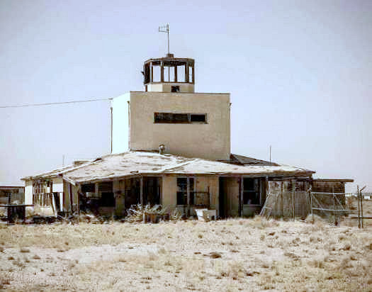
A 5/8/14 photo by Andrea Smith (of www.arizonaspecialtyphotography.com) of the sad looking remains of the Gary Field control tower.
A 5/8/14 photo by Andrea Smith (of www.arizonaspecialtyphotography.com) of the sole hangar which remains standing (barely) at the site of Gary Field.
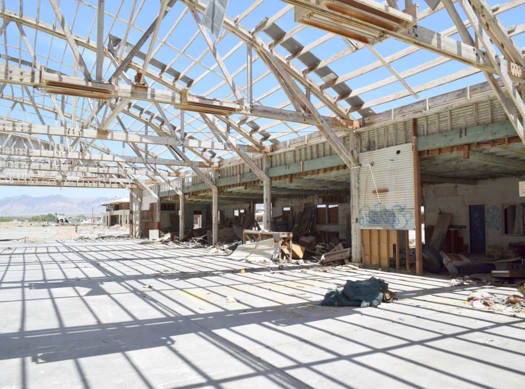
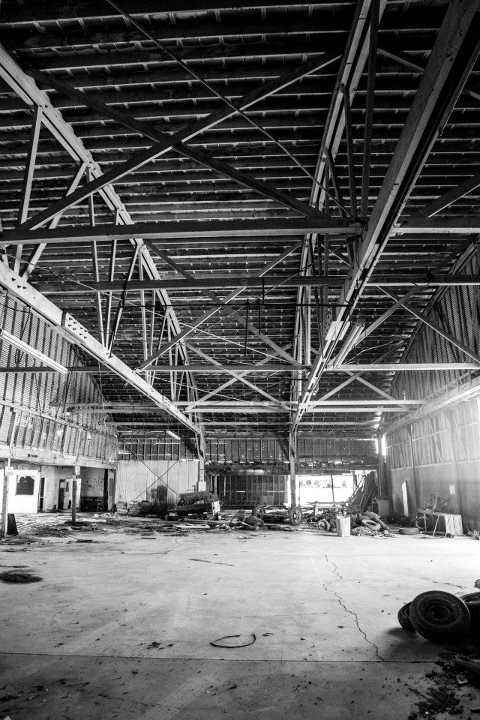
A 5/8/14 photo by Andrea Smith (of www.arizonaspecialtyphotography.com) of the exposed interior of the sole remaining hangar at the site of Gary Field.
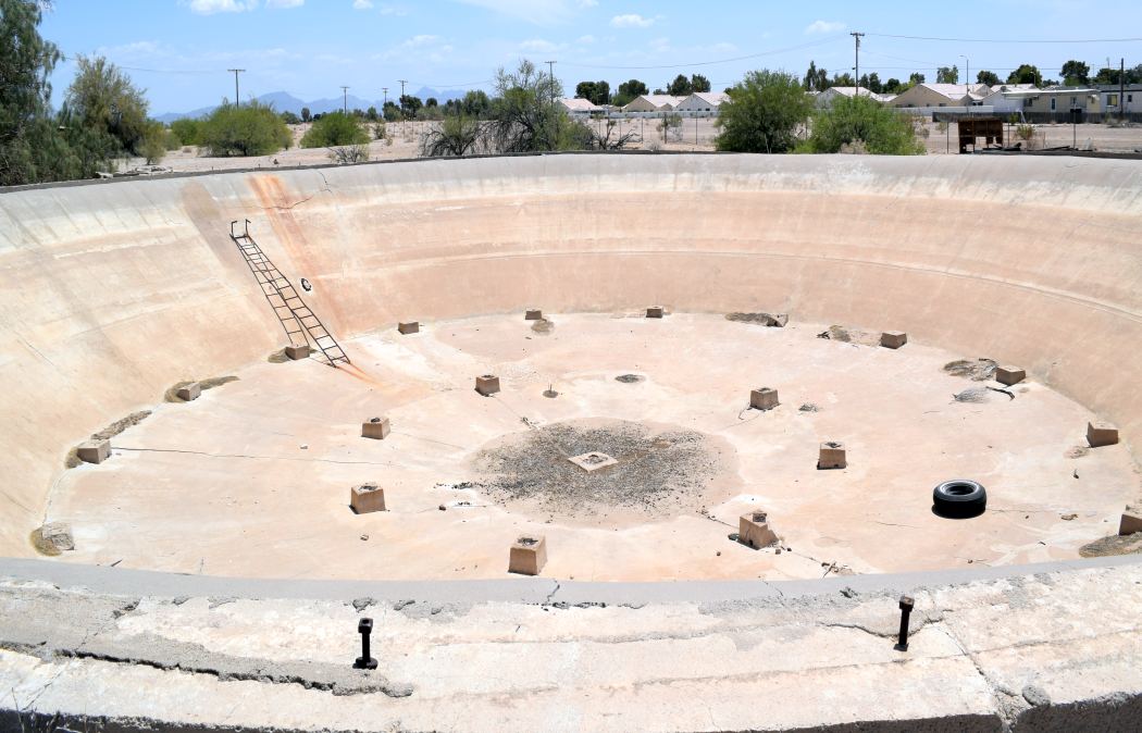
A 5/8/14 photo by Andrea Smith (of www.arizonaspecialtyphotography.com) of an unusual remnant at the site of Gary Field –
presumably the remains of an massive underground fuel storage tank.
Andrea Smith reported in 2014, “The property has a tax liability for approximately $53,000
so whomever comes up with the back taxes will be the proud owner of this old piece of history.”
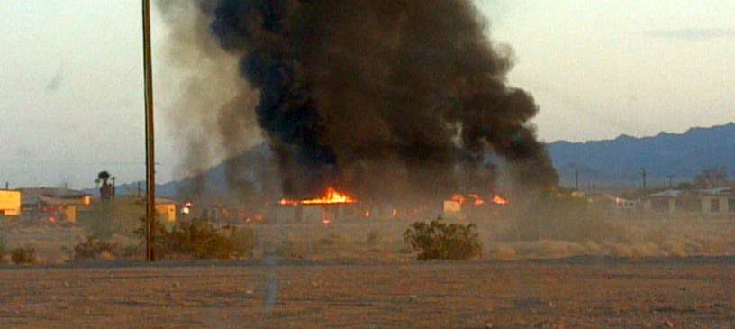
A 5/25/14 photo by Thomas Matthews (courtesy of Tyler McMillin) of a fire which tragically destroyed one of the historic Gary Field buildings.
Tyler reported, “This morning one of the buildings in the W.R. Byron Airport or the former Morton Air Academy was destroyed by a fire.
The fire was so big that it emitted a long stream of smoke.”
An article in the 6/3/14 issue of The Desert Independent (courtesy of Tyler McMillin) reported,
“On Sunday, May 25 the Blythe Police Department received numerous 911 calls at about 5:30 A.M.
regarding a structure on fire at the old Morton Air Academy (3500 block Wells Road).
The Blythe Fire Department responded & found 3 separate structures near the center of the gated property fully engulfed.
Due to the suspicious nature of the fire, Blythe Police Department investigators were called to the scene & are investigating the cause.
The 3 structures involved are over 70 years old & were a total loss.”
Tyler McMillin reported on 5/31/14, “I looked at the airport in the distance & most buildings including the big hangar are still standing.”
A 4/12/15 aerial view by John looking southeast at the remains of Gary Field,
showing that the building destroyed by the 2014 fire was one of the barracks buildings behind the flightline.
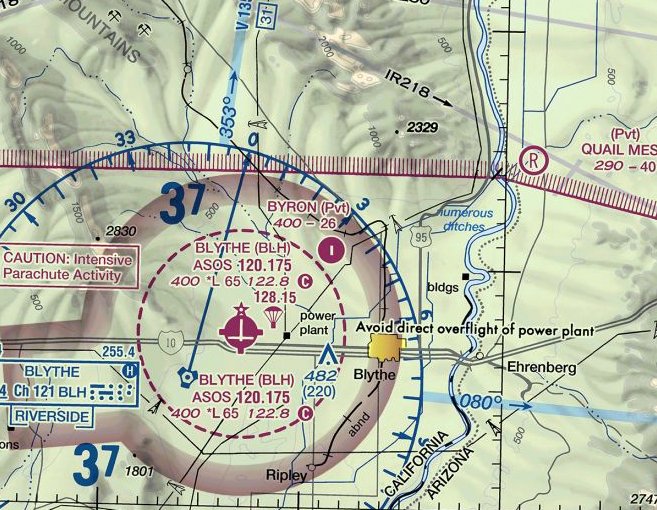
Inexplicably, the October 2016 Phoenix Sectional Chart continued to depicted “Byron” Airport on the site of Gary Field,
even though photos from the same era do not appear to show any aviation use.
Byron Airport was depicted as a private field having a single paved 2,600' north/south runway.
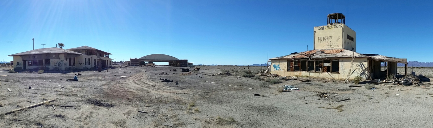
A 1/29/17 photo by Bud Stratford of the remains of the Gary Field buildings, hangar, and control tower.
Bud reported, “The facilities continue to degrade as vandals make their way onto the property & destroy everything in sight.
The magnitude of graffiti [relating to the 2016 Presidential election] we saw around the place indicates that the vandals have been working the site fairly recently, and on a widespread basis.
There are still oddities to be found. We happened upon the tail section of an Arkansas-based crop duster, just outside the hangar; just how such a plane section got here is completely baffling.
It was just the very tail of it; we couldn't even identify the type/make/model of the plane.
The only way we identified as much as we did, was a decal that was on the vertical stabilizer for an Arkansas crop dusting service.
But the sun had baked away most of the fabric; all it really was, was some jumbled-up, bent & broken steel tubing, and a few remnants of fabric that had survived in the shade.
Creepy! But well worth seeing nonetheless.”
A 1/29/17 photo by Bud Stratford of the Gary Field hangar. Bud reported, “The hangar is almost completely roof-less.”
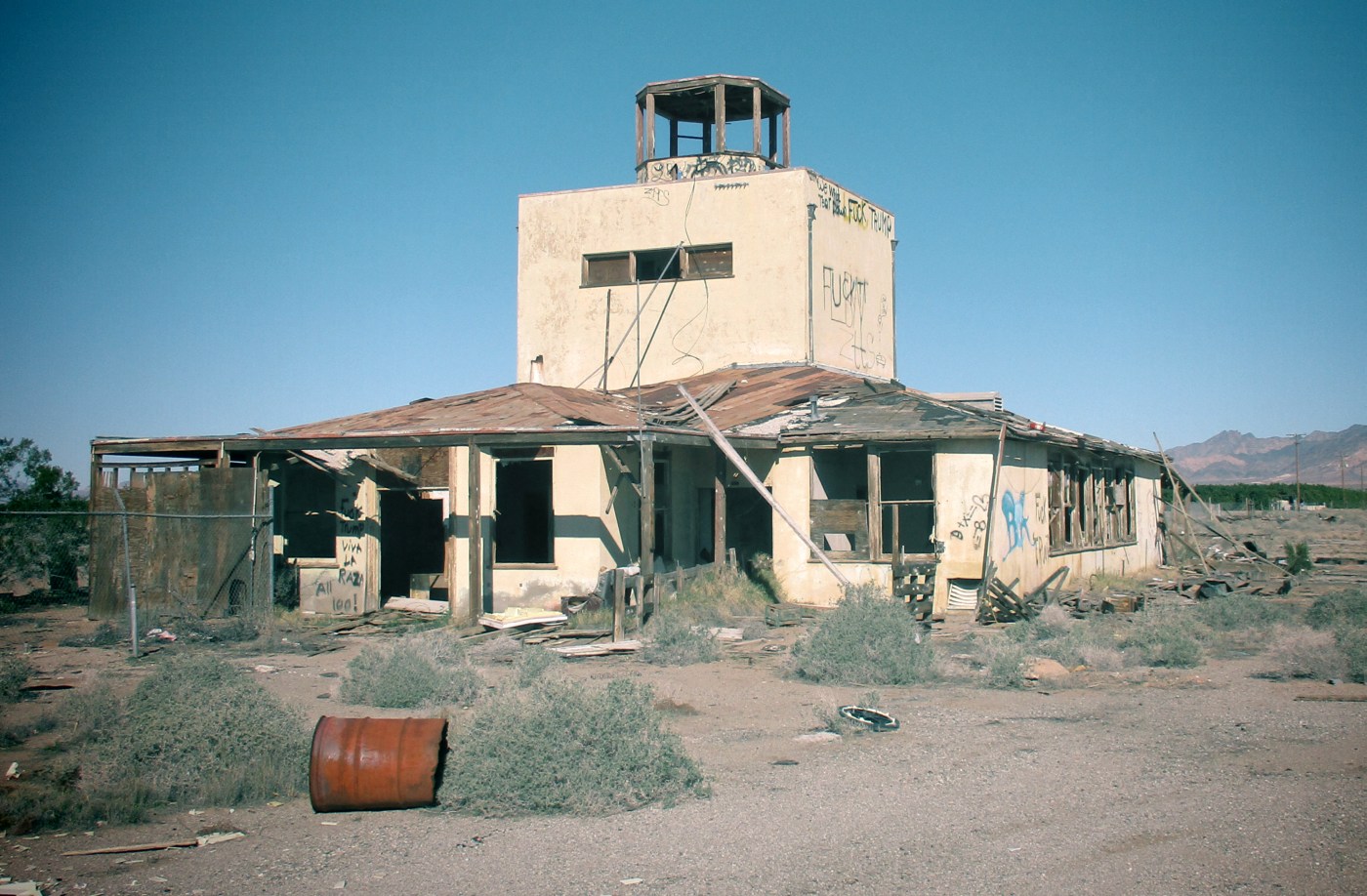
A 1/29/17 photo by Bud Stratford of the Gary Field control tower. Bud reported, “Many buildings are on the verge of collapse.
It was eerie & sad to see the state of things. If you want to see it for yourself, you might wanna hurry; I doubt it will freely stand for much longer.”
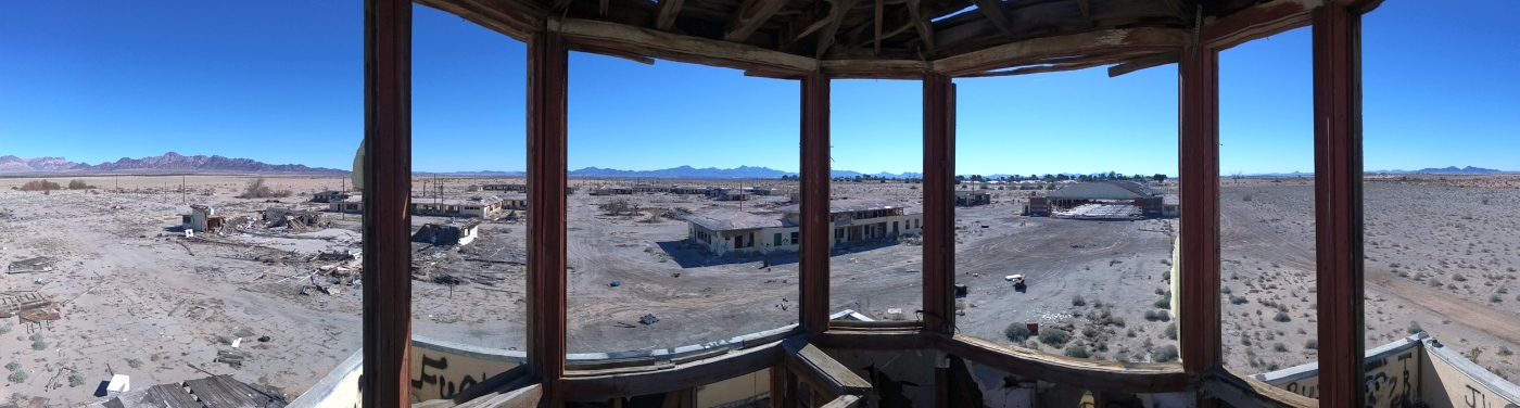
A 1/29/17 panoramic photo by Bud Stratford from the inside of the Gary Field control tower.
Bud reported, “Getting up to the tower was hazardous as hell.
It's accessible by stairs & a ladder... but the tons of broken drywall on the stairs makes it much more like a slippery waterfall of broken plaster & paper.
Thank God for all the exposed studs; we used those as hand-holds on the way up & down.”
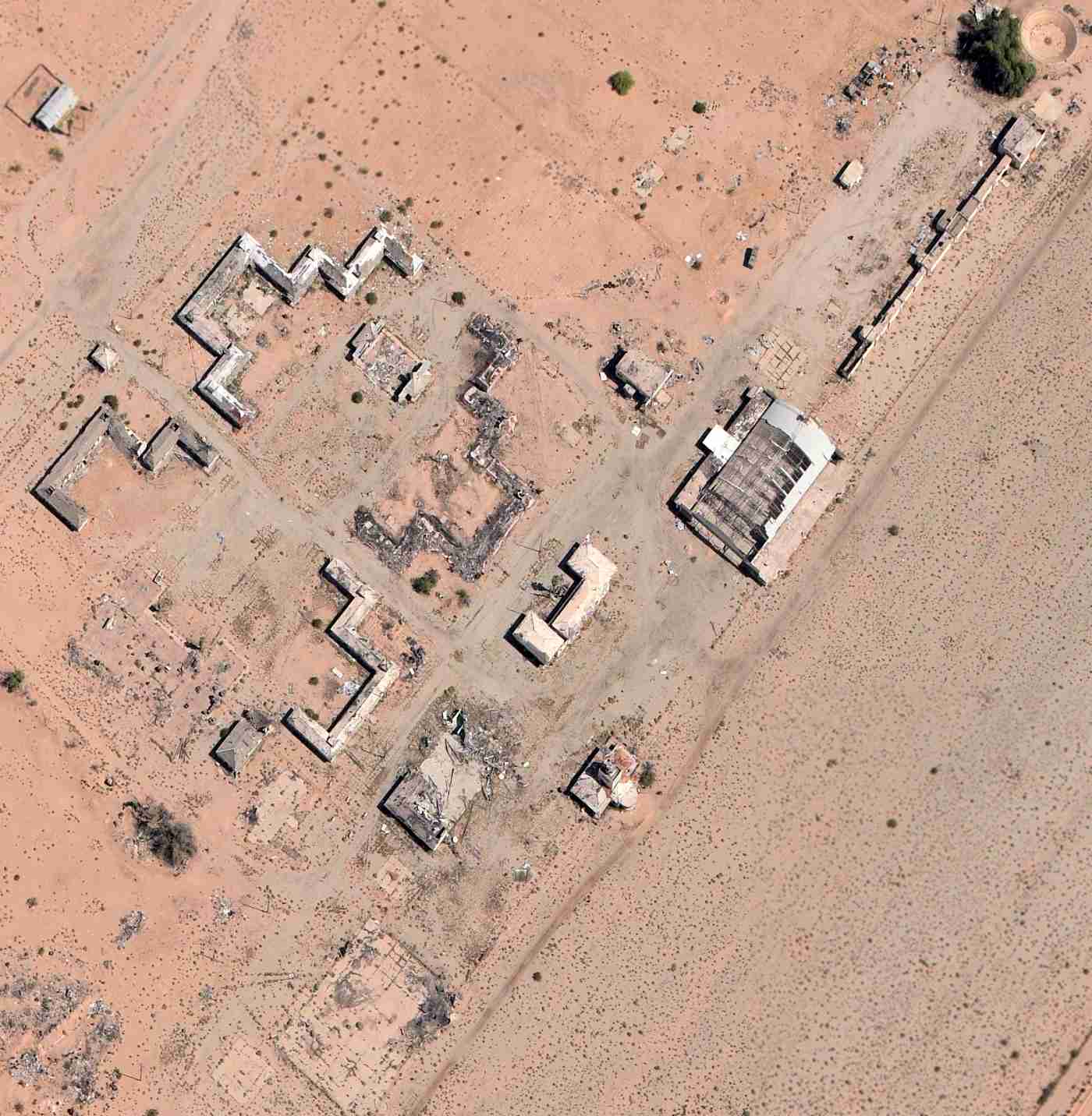
A sad 2026 aerial view show that almost all of the historic Gary Field buildings had been removed at some point between 2017-2026.
The site of Gary Field is located at the northwestern terminus of West Wells Road, 6 miles northwest of Blythe.
____________________________________________________
(Original) Desert Center Airport, Desert Center, CA
33.72, -115.39 (Northeast of Los Angeles, CA)
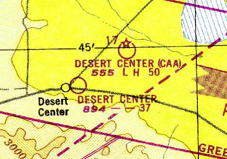
The original Desert Center Airport, as depicted on the February 1934 San Diego Sectional Chart (courtesy of Chris Kennedy).
Photo of the airport while open has not been located.
The original airport for the town of Desert Center was located adjacent to the northeast side of the town.
The date of construction of the Desert Center Airport has not been determined.
The earliest reference which has been located to Desert Center Airport
was in the 1929 Airplane Landing Fields of the Pacific West (courtesy of Chris Kennedy).
It described Desert Center as a private field owned by S. A. Ragsdale,
which was open to the public for emergency purposes.
The field was said to consist of sandy runways measuring 4,000' east/west & 2,600' north/south.
The Airport Directory Company's 1933 Airport Directory (courtesy of Chris Kennedy) described Desert Center as a commercial airport.
It was said to be a dirt field with 2 runways in a cross shape: 4,000' east/west & 2,600' north/south.
The Desert Center Airport apparently gained lights at some point between 1933-38,
as The Airport Directory Company's 1938 Airport Directory (courtesy of Chris Kennedy)
described the field as having beacon, boundary, and approach lights.
The airfield had also changed when compared with the 1933 directory: it was now described as having 2 sod runways in an “L” shape,
measuring 3,000' east/west & 2,600' north/south.
Note: it is a little optimistic that this field in the middle of the California desert had “sod” runways!
At some point between 1938-40 the Desert Center Airport started serving as one of the Department of Commerce's network of Intermediate Fields
(located for emergency use of commercial aircraft in between major cities).
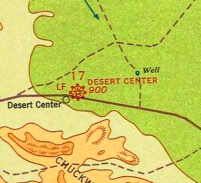
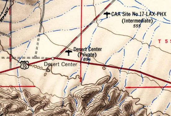
The August 1940 San Diego Sectional Chart (courtesy of Chris Kennedy) depicted Desert Center Airport as “Site 17” along the airway.
The Airport Directory Company's 1941 Airport Directory (courtesy of Chris Kennedy)
described the Desert Center Airport as the Civil Aeronautic Administration's Site 17 along the LA – Phoenix Airway.
The field was described as having 2 “gravelly sandy” runways in an “L” shape: 3,740' east/west & 2,860' north/south.
The August 1943 San Diego Sectional Chart (courtesy of Chris Kennedy) continued to depict the original Desert Center Airport,
but it also showed that the new Desert Center Army Airfield had been established closeby to the northeast.
Desert Center Airport was described in the April 1944 US Army/Navy Directory of Airfields (courtesy of Ken Mercer)
as as being Site 17 along the Los Angeles – Phoenix Airway.
It was described as having a 3,800' unpaved runway.
The Haire Publishing Company's 1945 Airport Directory (courtesy of Chris Kennedy)
described Desert Center Airport as CAA Intermediate Field #17.
It was said to be a “class 3” airfield, privately owned but operated by the CAA.
The manager was listed as Stanley Ragsdale.
The field was described as having 2 gravel runways: 3,740' east/west & 2,860' north/south.
The last chart depiction which has been located of the original Desert Center Airport as an active airfield
was on the March 1949 San Diego Sectional Chart (courtesy of Chris Kennedy).
It depicted Desert Center Airport as having a 3,700' unpaved runway.
The Desert Center Airport was evidently abandoned at some point between 1949-51,
as it was no longer depicted at all on the March 1951 San Diego Sectional Chart (courtesy of Chris Kennedy)
or the 1952 USGS topo map.

The 2 runways of Desert Center Airport were still depicted on a 1954 AAA map of Riverside County (courtesy of Chris Kennedy),
but it was labeled simply as “Landing Field”,
which most likely indicates that it was no longer an active airport by that point.
The 1954 USGS topo map depicted Desert Center as a private airfield.
The Desert Center Airport was no longer depicted at all on the 1963 USGS topo map.
A 1984 aerial photo, the outline of the former Desert Center Airport north/south runway was still intact,
and the outline of the east/west runway was also still somewhat recognizable, although it had been built upon.

In a 1996 USGS aerial view looking north, the outline of the former Desert Center Airport's north/south runway was still intact.
The outline of the east/west runway was also still somewhat recognizable, although it had been built upon.
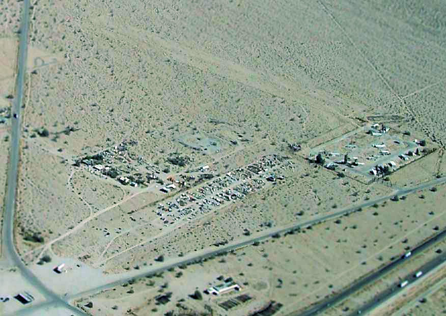
A 2006 aerial photo by Joe Merkert (enhanced by Bill Grasha) looking northeast at the original Desert Center Airport,
showing “the wrecked car storage facility on the southern runway with the north/south runway still clear.”

A 2016 aerial view looking north showed the outline of the former Desert Center Airport's 2 runways were still somewhat recognizable.
The Desert Center Airport is located northwest of the intersection of Route 177 & Ragsdale Road.
____________________________________________________
____________________________________________________
This site covers airfields in all 50 states.