
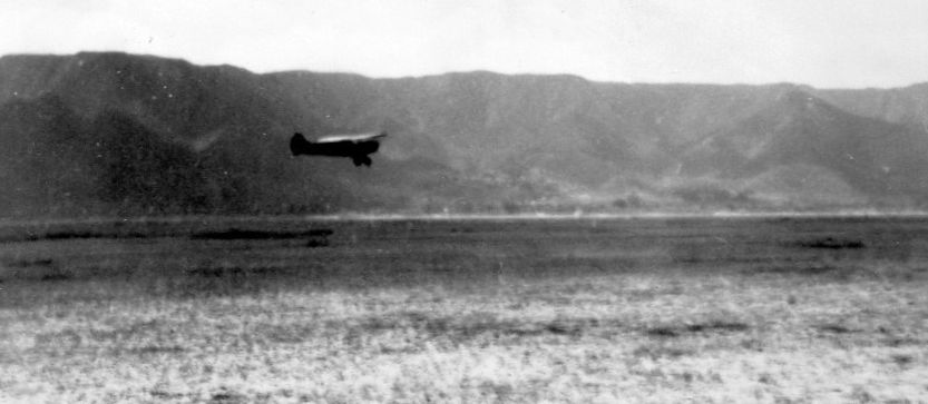
Abandoned & Little-Known Airfields:Thompsonw
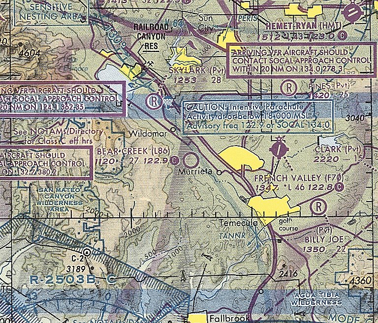
California: Western Riverside County
© 2002, © 2025 by Paul Freeman. Revised 3/18/25.
This site covers airfields in all 50 states: Click here for the site's main menu.
For a 10th year, the CA pages of this website are sponsored by the California Pilots Association:
____________________________________________________
Please consider a financial contribution to support the continued growth & operation of this site.
Calimesa Airport (revised 12/23/19) - Elsinore Airport (revised 5/28/21) - Glen Ivy Airport (revised 5/23/22)
Lake Mathews Airport (revised 10/28/16) - Murrieta Hot Springs Airport (revised 1/20/25) - Norconian Club Airfield (revised 12/24/18)
Rancho California Airport (revised 2/21/23) - Stony Bridge Ranch Airfield (added 11/3/19) - Thompson Field / Bear Creek Airport (revised 3/18/25)
____________________________________________________
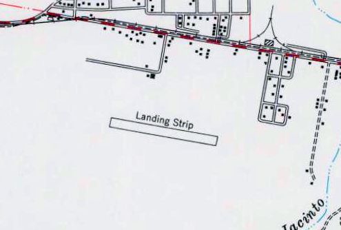
Stony Bridge Ranch Airfield, Corona, CA
33.85, -117.612 (East of Los Angeles, CA)
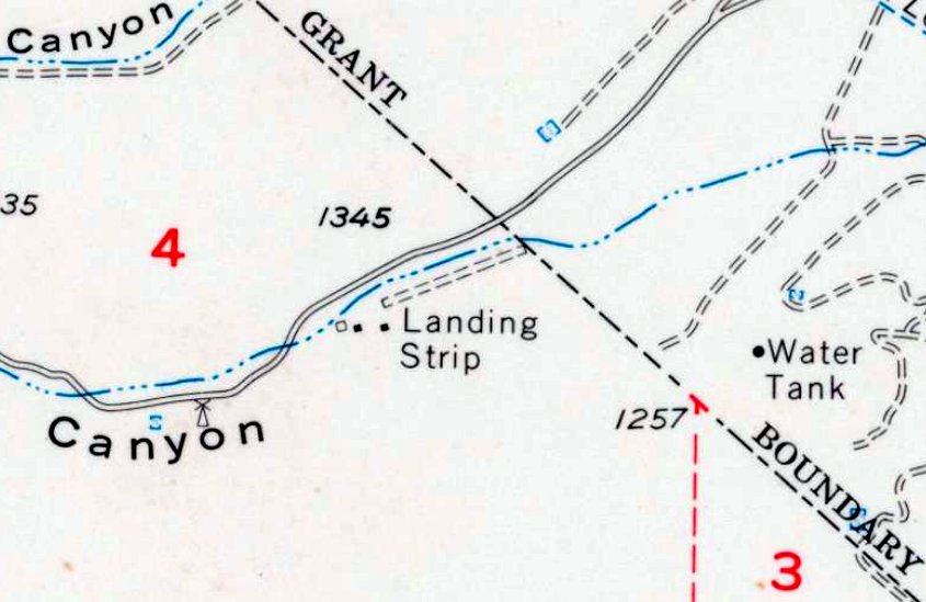
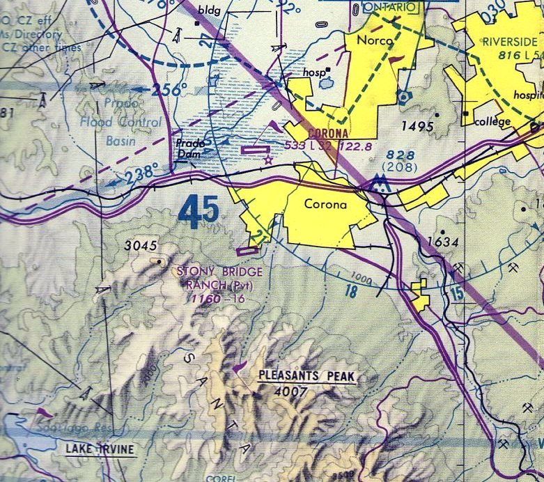
Stony Bridge Ranch Airfield, as depicted on the 1967 USGS topo map.
This small private airfield was evidently established at some point between 1948-66, as it was not yet depicted on a 1948 aerial photo.
The earliest depiction which has been located of Stony Bridge Ranch Airfield was a 1966 aerial photo.
It depicted a short unpaved northeast/southwest runway nestled into a canyon.
Stony Bridge Ranch Airfield was not yet depicted on the August 1967 San Diego Sectional Chart.
The 1967 USGS topo map depicted Stony Bridge Ranch Airfield as a short unpaved northeast/southwest runway, labeled generically as “Landing Strip”.
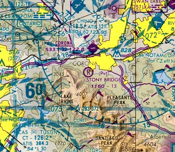
The earliest aeronautical chart depiction which has been located of Stony Bridge Ranch Airfield was on the February 1968 San Diego Sectional Chart.
It depicted Stony Bridge Ranch Airfield as a private airfield having a mere 1,000' unpaved runway.
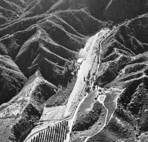
The earliest photo which is available of Stony Bridge Ranch Airfield was an 11/12/73 aerial view looking southwest (from CSU San Berbardino, courtesy of Jeff Rountree).
It depicted Stony Bridge Ranch Airfield as short runway nestled into a canyon, a 1-way airfield, with a building (possibly a hangar) on the south side.
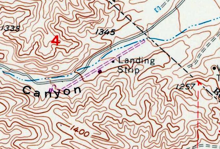
The 1973 USGS topo map depicted Stony Bridge Ranch Airfield as having a runway which had roughly doubled in length compared to the 1967 topo map.
The August 1980 LA Terminal Aeronautical Chart depicted Stony Bridge Ranch Airfield as a private airfield having a 1,600' paved northeast/southwest runway.
The last aeronautical chart depiction which has been located of Stony Bridge Ranch Airfield was on the January 1986 LA Sectional Chart.
It depicted Stony Bridge Ranch Airfield as a private airfield having a 1,300' unpaved runway.
Stony Bridge Ranch Airfield was evidently closed (for reasons unknown) at some point between 1986-87,
as it was no longer depicted on the July 1987 LA Sectional Chart (courtesy of John Voss).
The 2000 USGS topo map still depicted Stony Bridge Ranch Airfield as an unpaved northeast/southwest runway labeled generically as “Landing Strip”.
The 2012 USGS topo map no longer depicted Stony Bridge Ranch Airfield.
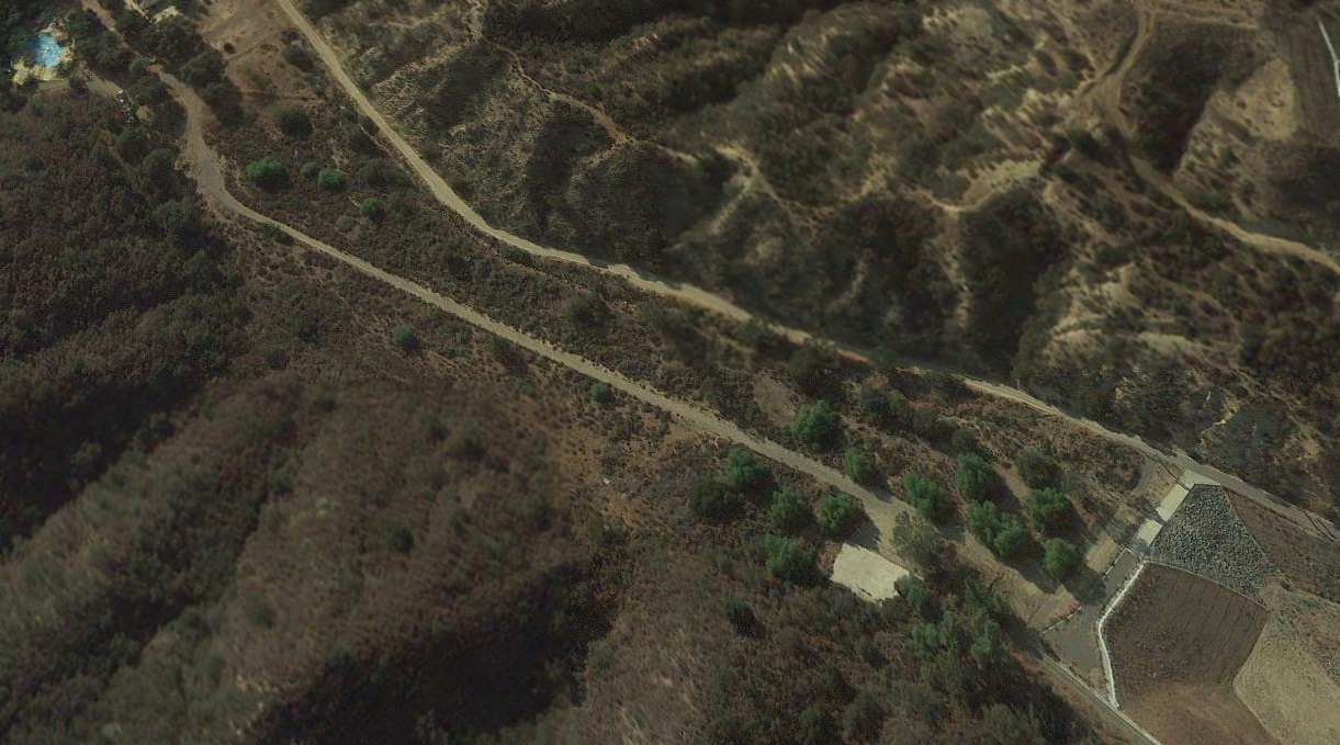
A 2018 aerial view looking northwest showed the remains of the paved runway at the site of Stony Bridge Ranch Airfield,
and the foundation of the possible former hangar (the light-colored concrete pad to the bottom-right of the runway).
The site of Stony Bridge Ranch Airfield is located southwest of the intersection of Foothill Parkway & Mabey Canyon Road.
Thanks to Jeff Rountree for pointing out this airport.
____________________________________________________
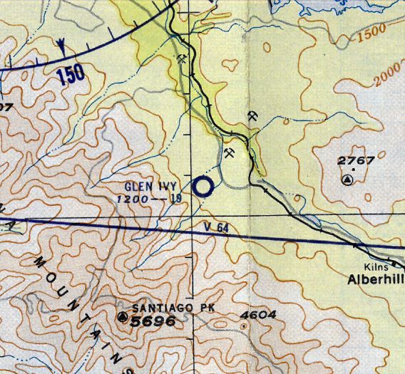
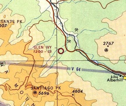
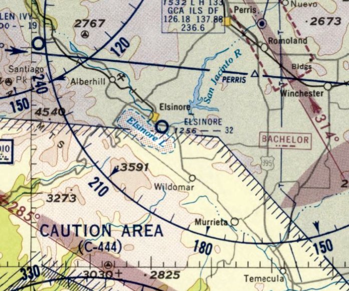
33.762, -117.495 (Southeast of Los Angeles, CA)
Glen Ivy Airport, as depicted on the March 1949 San Diego Sectional Chart.
The date of establishment of this small general aviation airport has not been determined.
Glen Ivy Airport was not yet depicted on the September 1948 San Diego Sectional Chart.
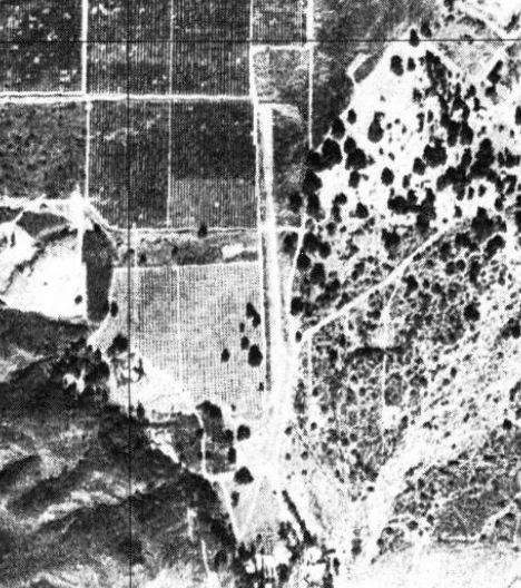
The earliest depiction which has been located of Glen Ivy Airport was a 1948 aerial photo.
It depicted a single north/south runway, with 2 small single-engine planes parked on a clearing to the southwest.
The earliest aeronautical chart depiction which has been located of Glen Ivy Airport was on the March 1949 San Diego Sectional Chart.
It depicted Glen Ivy Airport as having a 2,200' unpaved runway.
Harry Gordon recalled, “My logbook shows I flew a Cub from Compton to Glen Ivy & back on 5/2/51.
My passenger was my future (first) wife, and that was my last log entry before I shipped out for Korea on an aircraft carrier.
The runway was inclined such that our landing was uphill & takeoff was downhill.
It also had a little bend in it toward the lower end, as can be seen in one of the illustrations;
the only runway I ever saw that required a slight turn along the way.
We had a swim at the Glen Ivy Hot Springs swimming pool while we were there.”
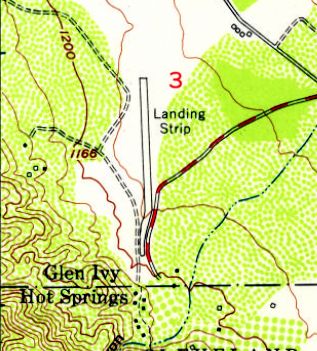
The 1953 USGS topo map depicted Glen Ivy Airport as a single north/south runway, labeled simply as “Landing Strip”.
The 1956 LA Local Aeronautical chart depicted Glen Ivy Airport as having a 1,900' unpaved runway.
John Graybill recalled, “Glen Ivy Airport... I first landed there in 1962.”
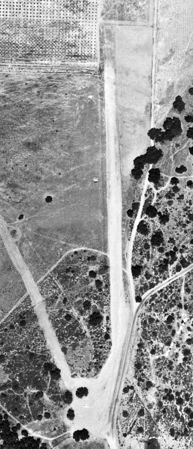
The earliest photo which has been located of the Glen Ivy Airport was a 6/24/63 USGS aerial view.
It depicted Glen Ivy Airport as having a single unpaved north/south runway.
One light single-engine aircraft was parked on the southwest side, but there did not appear to be any hangars or other airfield buildings.
The 1965 LA Local Aeronautical Chart depicted Glen Ivy Airport as having a 1,900' unpaved runway.
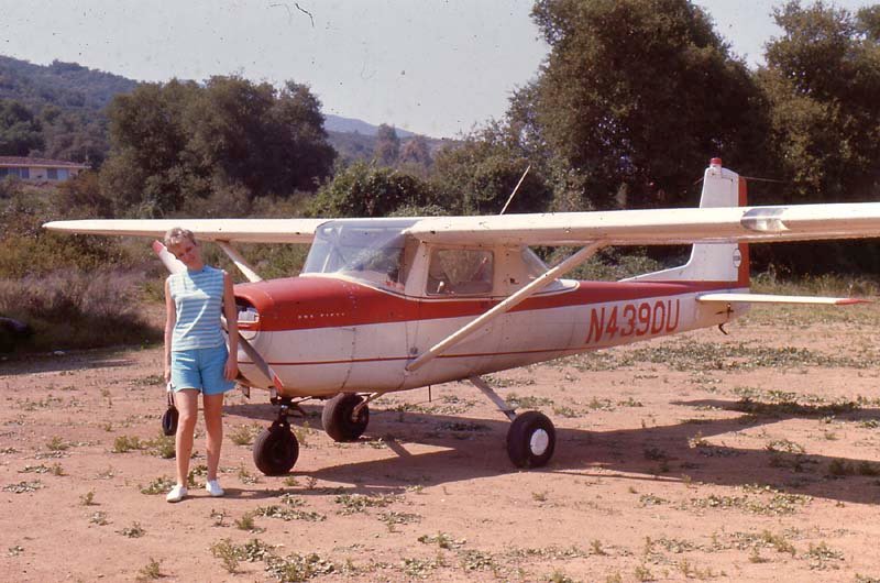
The only ground-level photo which has been located of Glen Ivy Airport was a circa 1965 photo by Bob Cannon of his Cessna 150D.
Bob reported, “I had always heard that it was a nudist colony. The strip had a curve in it. The aircraft was a low-time 1964 that I bought from Sky Roamers for $5,000.”
The 1967 USGS topo map depicted Glen Ivy Airport as having a single unpaved north/south runway.
The last photo which has been located of Glen Ivy Airport was a 1967 aerial photo.
It depicted a single north/south runway, with 1 small single-engine plane parked on a clearing to the southwest.
The last aeronautical chart depiction which has been located of Glen Ivy Airport was on the 1969 LA Sectional Chart.
It depicted Glen Ivy Airport as having a 1,900' unpaved runway.
A 1974 USGS aerial photo depicted Glen Ivy Airport as having a single unpaved north/south runway.
Glen Ivy Airport was evidently closed (for reasons unknown) at some point between 1969-78,
as a 1978 aerial photo showed portions of the runway had been subdivided for other purposes.
Glen Ivy Airport was no longer depicted on the 1979 LA Sectional Chart.
A 2016 aerial view showed no trace remaining of Glen Ivy Airport.
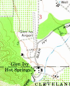
The site of Glen Ivy Airport is located west of the terminus of Glen Ivy Road.
Thanks to John Graybill for pointing out this airport.
____________________________________________________
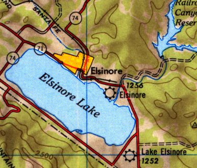
Elsinore Airport, Lake Elsinore, CA
33.658, -117.316 (Southeast of Los Angeles, CA)
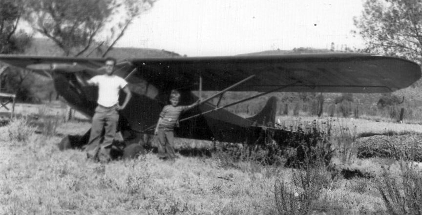
An October 1946 photo of Joseph & Paul Templeton in front of Joseph's Piper J-2 Cub at Elsinore Airport.
Paul Templeton recalled, “My parents bought some land near Lake Elsinore just prior to the outbreak of WW II & constructed a cabin for a weekend retreat.
After the war my father [Joseph] became interested in flying.
He subsequently was introduced to Earl Medlicott who had leased some land along what is now East Lakeshore Drive
about midway between the Elsinore community & where the Mission Trail Plaza Shopping Center is now located.
He named his business Elsinore Airport.
Mr. Medlicott had been a civilian flight instructor in TX during the war and, given the post-war civilian 'aviation boom', saw an opportunity for a successful business.
My father subsequently purchased a Piper Cub J-2 (NC19211) & took flying lessons from Mr. Medlicott.
Dad kept his J-2 at the airport starting in 1946.”
Elsinore Airport was not yet depicted on the August 1946 San Diego Sectional Chart.
Paul continued, “The airport had no paved runways & was quite primitive in nature.
The airport office was in a small house where Mr. Medlicott & his wife, Ida resided.
A crude overhead was constructed of telephone poles & war surplus netting in 1947.
This did not work out, so a large (probably about 100x100') cinderblock hangar was begun, but never really finished.
Avgas was available from a hand-pumped above-ground tank.
At least one air show was held at the Elsinore Airport, about fall 1947.”
Paul continued, “Several aircraft were kept at the airport.
I can recall a Cessna UC-78 & a Waco cabin float plane (stored on cribbage).
Mr. Medlicott owned a Piper Cub J-3 which he used for giving flight lessons.
In addition, he purchased a pair of war surplus Vultee BT-13 trainers.
One was a 'hangar queen' but the other was flown frequently.
A local flying club kept a Aeronca (pre-Champion) at the field.
Also kept at the airport was a Fairchild PT-19. I copped rides in some of these birds.”
Paul continued, “Alas, the airport was not a commercial success (Skylark, then known as Lake Elsinore Airport, provided active competition).
Mr. Medlicott took on a position as a Elsinore Police officer to make ends meet.
A 1946-47 photo (courtesy of Paul Templeton) looking east at Joseph Templeton in front of a Piper J-2, and a Waco floatplane in the background, at Elsinore Airport.
A 1946-47 photo (courtesy of Paul Templeton) looking northeast at Earl Menditcott (“a very tall man”) with his Piper J-3 at Elsinore Airport.
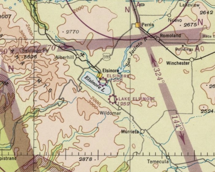
The earliest aeronautical chart depiction which has been located of the Elsinore Airport was on the February 1947 San Diego Sectional Chart.
Note it also depicted the similarly-named Lake Elsinore Airport nearby to the southeast.
Elsinore Airport, as depicted on the 1947 USGS topo map (along with the similarly-named Lake Elsinore Airport nearby to the southeast).
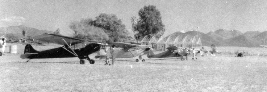
A 1947 photo (courtesy of Paul Templeton) of a row of aircraft at Elsinore Airport.
Paul Templeton observed, the aircraft are “Looking left-to-right, a BT-13, our J-2 with my mother & me, a Piper Cub 75hp Cruiser, an Aeronca, a J-3, and a Piper Cub 100hp Cruiser.
The hangar being constructed shows in the background as does the eucalyptus tree.”
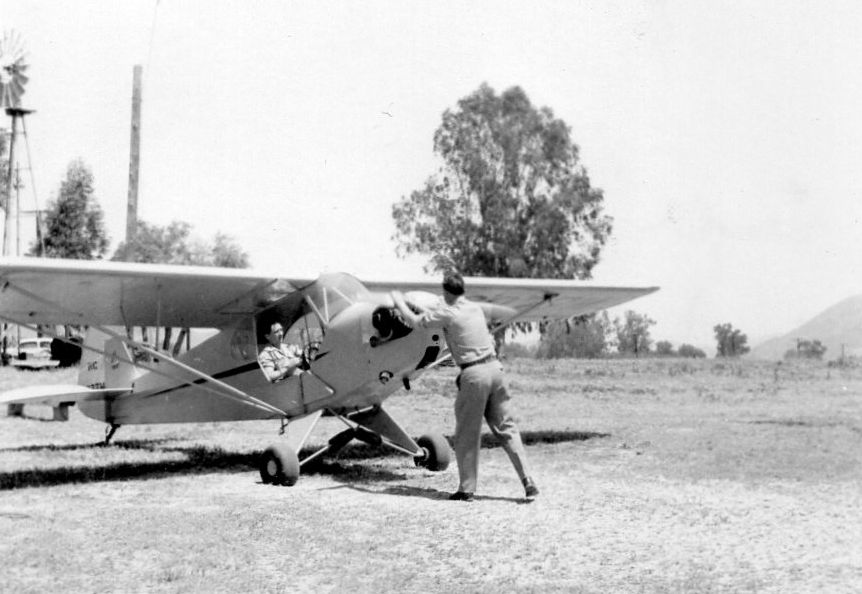
A 4/19/47 photo (courtesy of Paul Templeton) looking southeast at Elsinore Airport of “Mr. Medlicott cranking the J-3, with my Father's friend from LA in the rear seat.
A pole for temporary overhead &d the eucalyptus tree in background. The gas tank was near the windmill.”
A March 1947 photo (courtesy of Paul Templeton) looking west at a Piper J-2 Cub taking off from Elsinore Airport.
Paul Templeton observed, “Coast Range in the background. Unimproved nature of the field readily apparent.”
Paul Templeton recalled, “Dad kept his J-2 at the airport until 1948 when he sold the airplane.
Dad had his final check ride out of the airport in May 1949.
The field remained active until we left Southern CA in June 1949.
I do not know what happened to Mr. Medlicott & his wife after we departed SoCal.”
The 1953 USGS topo map depicted Elsinore Airport as a single northwest/southeast runway, labeled simply as “Landing Strip”.
The last aeronautical chart depiction which has been located of the Elsinore Airport was on the March 1958 San Diego Sectional Chart.
It depicted Elsinore Airport as having a 3,200' unpaved runway.
Elsinore Airport was evidently abandoned (for reasons unknown) at some point in 1958,
as it was no longer depicted on the October 1958 San Diego Sectional Chart.
Paul Templeton recalled, “In October 1969 I visited the airport site.
The hangar remained but all that was left of the the office/residence was the foundation.
In 1969 our cabin remained intact & my parents & me stayed there for a few days.
It was a simple matter to walk across the dry lakebed to where the hangar was still extant.
Our cabin was destroyed by vandals in the early 1970s & my Dad sold the property it had stood on in the late 1970s.”
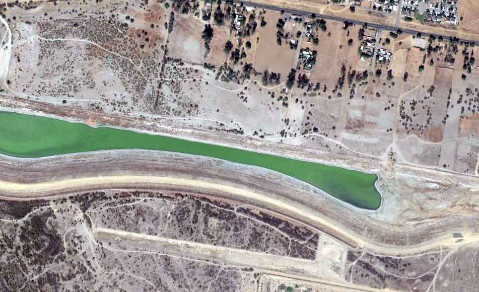
A 2016 aerial view showed the location of the Elsinore Airport had been flooded by a narrow inlet extending southeast from the lake.
Paul Templeton observed, “I found what appears to be the remains of the hangar floor off the end of Lucerne Street,
just beyond the tree line where Lucerne has degenerated into what appears to be a dirt path.
This ties in with what I can recall. Mr. Medlicott had placed a red beacon light on a pole in the top of a tall eucalyptus tree just to the south of the hanger. It could well still be there.”
____________________________________________________
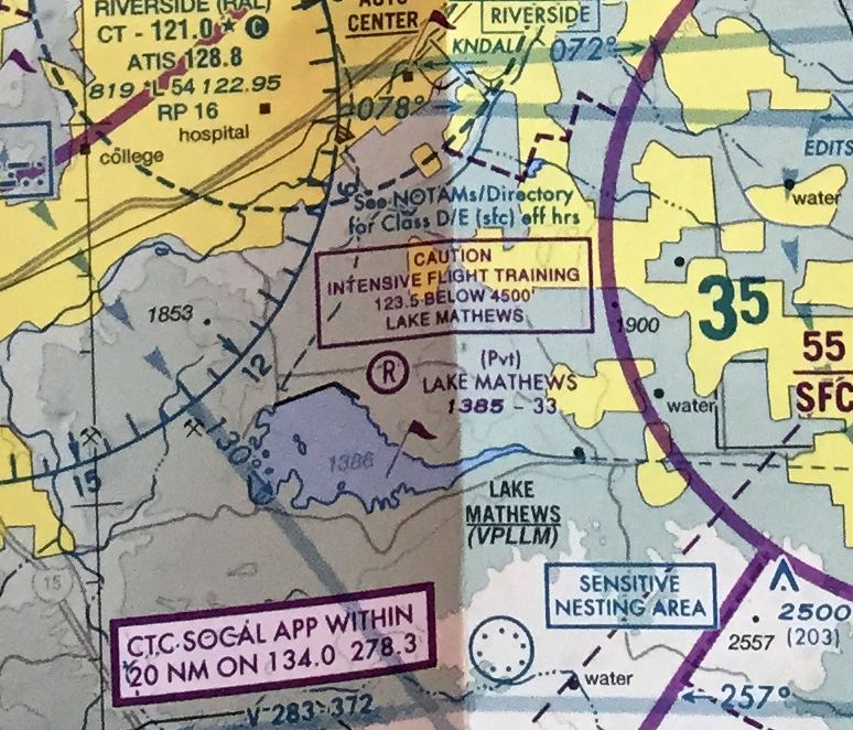
Lake Mathews Airport (52CA), Lake Mathews, CA
33.853, -117.427 (East of Los Angeles, CA)
The 1988 USGS topo map depicted the single paved east/west runway, ramp, and hangar of Lake Mathews Airport, but without any label.
Lake Mathews Airport was evidently established at some point between 1982-88,
as it was not yet depicted on a 1980 USGS aerial photo, the August 1980 LA Terminal Aeronautical Chart, or the 1982 USGS topo map.
The earliest depiction which has been located of Lake Mathews Airport was on the 1988 USGS topo map.
It depicted the single paved east/west runway, ramp, and hangar of Lake Mathews Airport, but without any label.
Gil Aguilar recalled, “Lake Matthews Airport was operated by the Metropolitan Water District. They operated a [Beechcraft] Baron.
Lake Matthews serves as reservoir for a pipeline from the Colorado River.”
The earliest photo which has been located of the Lake Mathews Airport was a 1994 USGS aerial view looking southeast.
It depicted Lake Mathews Airport as having a single asphalt east/west runway,
with a ramp & a small\ hangar on the southwest side of the runway.
The 1997 USGS topo map depicted the single paved east/west runway, ramp, and hangar of Lake Mathews Airport, but labeled it simply as “Landing Strip”.
Lake Mathews Airport was not depicted on the January 1998 LA Sectional Chart.
A 2009 aerial view looking southeast depicted the Lake Mathews Airport runway being marked with “R” (as a private airfield).
The only aeronautical chart depiction which has been located of the Lake Mathews Airport was on the 2009 LA Terminal Aeronautical Chart.
It depicted Lake Mathews Airport as a private field having a 3,300' unpaved runway.
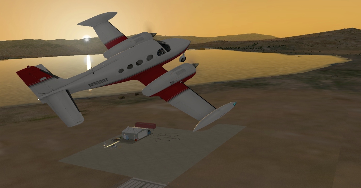
A flight simulator scenery depiction looking southwest at a Cessna 414 overflying the Lake Mathews Airport ramp & hangar at sunset.
The Lake Mathews Airport was evidently closed (for reasons unknown) by 2010, as the runway was marked with yellow closed-runway “X” symbols.
Lake Mathews Airport was no longer depicted on the June 2016 LA Sectional Chart.
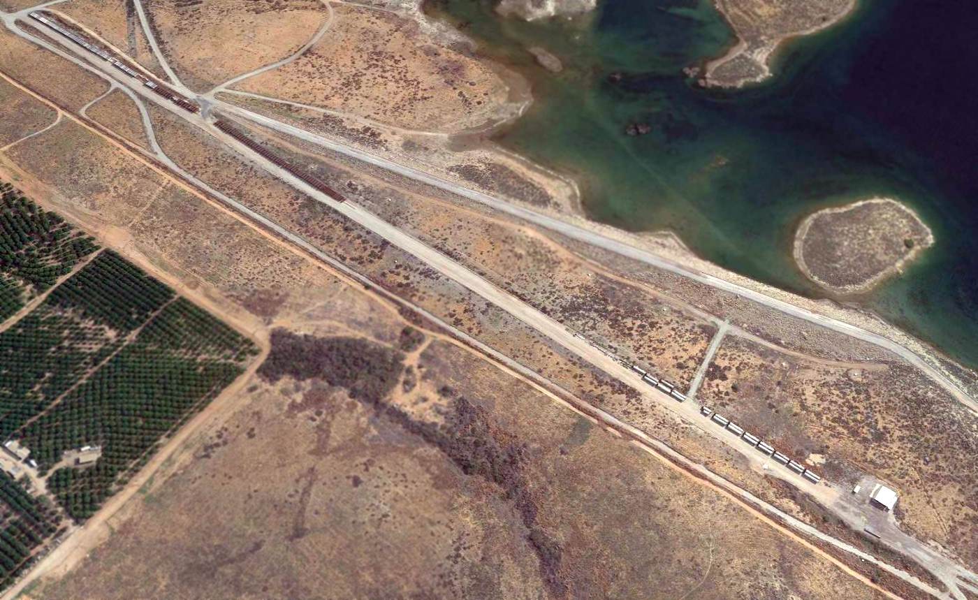
A 2016 aerial view looking southeast showed the Lake Mathews Airport runway & hangar remained intact, but the runway was being used to store unidentified objects.
Lake Mathews Airport is located southeast of the intersection of El Sobrante Road & McAllister Street.
____________________________________________________
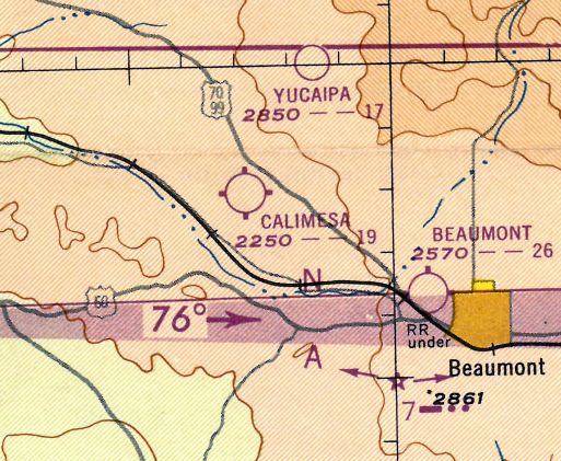
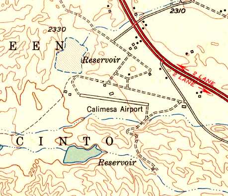
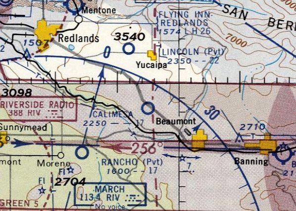
Calimesa Airport, Calimesa, CA
33.97, -117.05 (East of Los Angeles, CA)
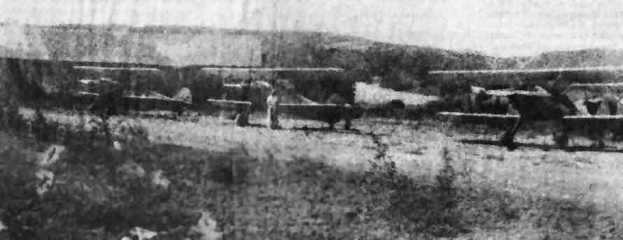
A 1946-47 photo (enhanced by Bill Grasha) of the Surber brothers' 3 Stearman biplanes at Calimesa Airport.
The Calimesa Airport was not yet depicted among active airfields in the 1945 AAF Airfield Directory (courtesy of Scott Murdock)
nor depicted on the 1945 San Diego Sectional Chart (courtesy of John Voss).
According to Mike Berry, “Vi [Violis] Surber lived on the property with his wife & 4 children before there was a field there
and the property was owned by the local water district.
Vi asked permission & they let him mow the field & let him put the runway in.
It was 1945 when Vi started the field. He & his family maintained the field.
The house they lived in was a old Stage Coach way back.”
According to an article in the 4/3/91 issue of the Yucaipa & Calimesa News-Mirror (courtesy of Mike Berry),
two brothers, Violis & Pete Surber, established an airfield in the 1940s on land belonging to the water district.
The barn on the property became a hangar,
and the 2 brothers bought junked aircraft & rebuilt them.
Aircraft operated from Calimesa included Stearmans, Cessnas, and Fairchilds.
Violis Surber registered the airfield with the FAA in 1945.
Mike Berry reported, “My father got out of the Army in 1946 & that's when he started flying out of Calimesa.
He owned a few different airplanes with Violis Surber & Rufus Biddix. They had a PT-17 Stearman & a PT-19. They also had a Luscombe.
My Dad was Jack Berry & he met my Mom in 1949 & their first date was in the Stearman.
My father had a wonderful time in those days & met many people that became friends.”
The earliest depiction of Calimesa Airport which has been located
was a 1946-47 photo of the Surber brothers' 3 Stearman biplanes at Calimesa Airport.
Calimesa Airport was not yet depicted on the February 1947 San Diego Sectional Chart.
The earliest aeronautical chart depiction which has been located of the Calimesa Airport was on the 1947 LA Local Aeronautical Chart (courtesy of Tim Zukas),
which depicted Calimesa Airport as having a 1,900' unpaved runway.
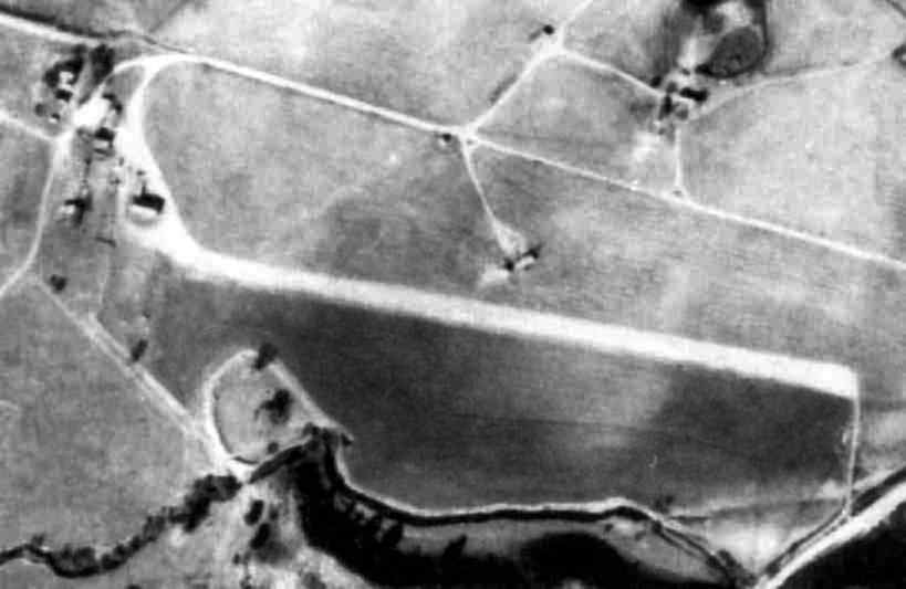
A 1948 aerial photo (from Riverside Flood Control, courtesy of Mike Berry, (enhanced by Bill Grasha)
depicted Calimesa Airport as having a single unpaved southeast/northwest runway,
with a few small buildings on the northwest & north side of the runway.
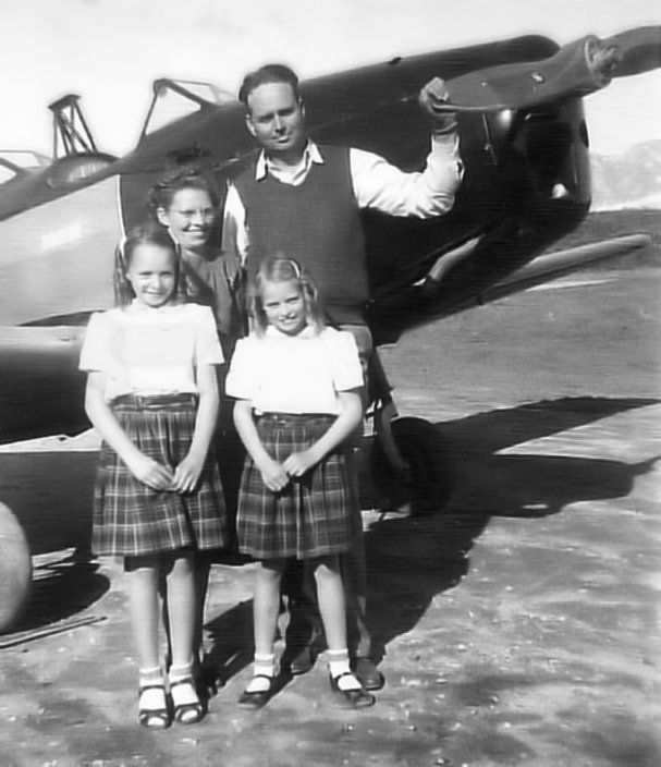
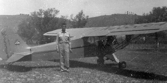
A circa 1940s photo of Calimesa Airport founder Vi Surber with his wife Mary & daughters Rosie & Sharon in front of a Fairchild PT-19 (courtesy of Mike Berry, (enhanced by Bill Grasha).
A circa 1940s photo of a surplus PT-19 in front of a barn at Calimesa Airport (courtesy of Mike Berry, (enhanced by Bill Grasha).
According to Mike Berry, “Those barns were 90 years old back in the 1940s.”
A circa 1940s photo of a Stearman biplane at Calimesa Airport (courtesy of Mike Berry, (enhanced by Bill Grasha).
A circa 1940s photo of a group in front of a Stearman at Calimesa Airport (courtesy of Mike Berry, (enhanced by Bill Grasha).
Mike reported, “My Dad [Jack Berry] is the 2nd from the right. He & the fellow to his right owned the PT-17 Stearman.”
According to an article in the 4/3/91 issue of the Yucaipa & Calimesa News-Mirror (courtesy of Mike Berry),
Calimesa was used for flight training, and also for aerial photography using a Stearman biplane.
The Surber family moved off the airport land in 1950, which made maintaining the strip more difficult.
The airport's heyday ended in 1953 when the expense of operating the aircraft became too great.
The 1953 USGS topo map depicted the Calimesa Airport as having a single northwest/southeast runway, with several small buildings on the west & north sides.
Mike Berry reported of his father's flying from Calimesa Airport: “The last entry in his logbook was in 1956.”
The last aeronautical chart depiction which has been located of the Calimesa Airport was on the September 1957 San Diego Sectional Chart.
It depicted Calimesa Airport as having a 1,700' unpaved runway.
According to an article in the 4/3/91 issue of the Yucaipa & Calimesa News-Mirror (courtesy of Mike Berry),
Calimesa Airport founder Violis Surber was killed by a drunk driver in 1957.
According to his daughter Rosie Adams, “He flew all those years, and then was killed on a freeway.”
The date of Calimesa Airport's closure has not been determined, but it was presumably shortly after 1957.
According to Mike Berry, Calimesa Airport “closed in 1957 or so.”
Sharon Lewis (daughter of Calimesa Airport founder Violis Surber) recalled,
“The airstrip always gave me a love of airplanes.
The airplanes were pure entertainment, and the camaraderie of the men who flew them,
the way they would talk & describe the way they flew, is something I will always remember.”
Surber's other daughter, Rosie Adams, recalled, “I didn't realize how unique our airstrip was.
It wasn't until I was older that I realized everybody doesn't have an airport.”
Calimesa Airport was no longer depicted on the March 1958 San Diego Sectional Chart.
A 1959 aerial view showed that the runway was no longer discernible – replaced by a farmed field.
The building on the north side of the runway had been removed at some point between 1948-59,
but the buildings on the northwest side still remained.
A 1967 aerial view showed that the buildings on the northwest side of the runway had been removed at some point between 1959-67.
A 1991 newspaper photo (courtesy of Mike Berry, (enhanced by Bill Grasha) of a windsock pole & frame – all that remained of Calimesa Airport.
A 11/16/09 aerial view no longer depicted any trace of Calimesa Airport, but the site remained an open field.
The site of Calimesa Airport is located west of the intersection of Roberts Road & Cherry Valley Boulevard.
____________________________________________________
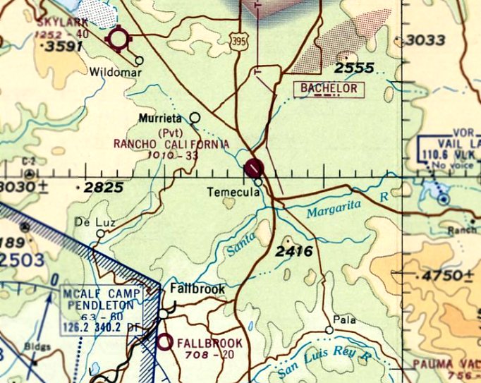
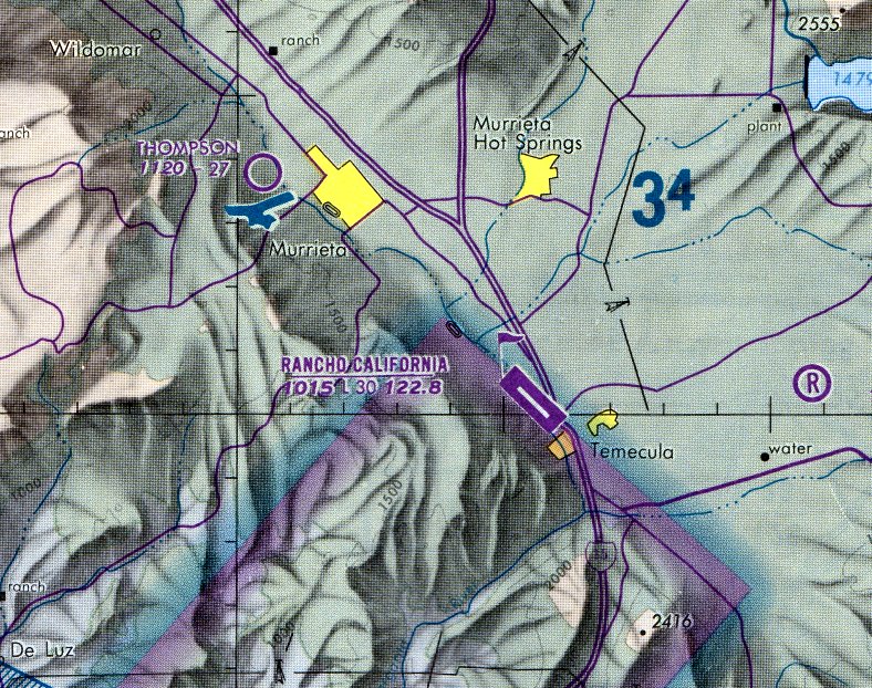
Rancho California Airport (2L0), Temecula, CA
33.5, -117.16 (North of San Diego, CA)
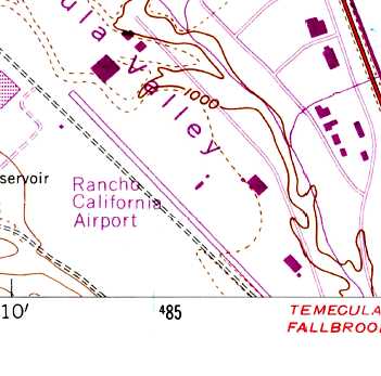
The earliest depiction which has been located of the Rancho California Airport was a 1967 USGS aerial view.
A 1947 aerial view did not yet depict any sign of an airfield at this location.
According to a report prepared by Anne Miller for the Temecula Valley Historical Society,
“In the mid-1960s, the LA Times began running large advertisements about Rancho California,
a new 87,000-acre planned community in the Temecula Valley.
In the Times on 11/6/66, there was a photograph that showed a helicopter 'towing' an antique plow
at the groundbreaking of the Rancho California Airport.”
According to the report by Anne Miller, “Bill Harker flew into he airport in the early years.
He reported that the first time he landed there, it was just a 1,200' gravel strip with one hangar, a small office, and a few planes tied down.
He was told that the airport was originally graded by some of the contractors who were building the original Ranch California Plaza (now Tower Plaza)
because they commuted by plane to the job site.”
The earliest depiction of Rancho California Airport which has been located was a 1967 USGS aerial photo,
It depicted the airport with a single paved runway & at least one paved taxiway.
There did not yet appear to be any hangars or other buildings at the airfield,
and there also did not yet appear to be any aircraft based at the field.
Rancho California Airport was not yet depicted on the February 1968 San Diego Sectional Chart.
According to K.O. Eckland, Rancho California Airport was described in a 1968 Jeppesen Airport Directory as having a 3,465' paved runway.
The earliest aeronautical chart depiction which has been located of Rancho California Airport was on the August 1968 San Diego Sectional Chart.
It depicted Rancho California Airport as a private airfield having a single 3,300' paved northwest/southeast runway.
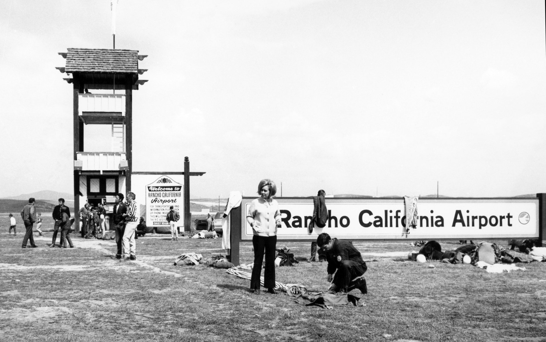
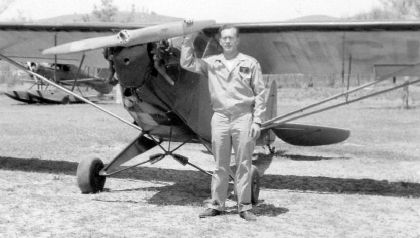
A circa 1968 photo by Kenneth McCreedy of parachutists & spectators near an observation tower & the Rancho California Airport sign (courtesy of David McCreedy).
Jeff Jacobs recalled, “As a flight instructor at Long Beach in 1971-72, I liked to take students to the old Rancho California Airport. It was good practice for them.
Because of the ridge next of the airport, it was impossible to see the airport until you were almost on top of it; and that ridge also made for some squirrelly crosswinds.”
The 1973 USGS topo map depicted the Rancho California Airport as having a single northwest/southeast paved runway,
with a few small buildings along the east side.
According to the report by Anne Miller, “When Bill Harker flew into Rancho California Airport again in 1974,
it had been lengthened & paved.
He noted that the Unicom transceiver was located in the office of the old Rancho Inn
in the old Plaza on the edge of the pond (where the Tower Plaza is located today).”
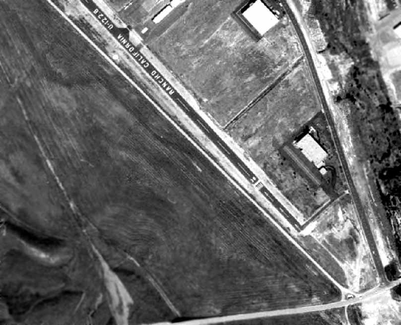
A 1976 aerial photo of a portion of the Rancho California Airport depicted the field as having a single paved runway, with several paved taxiways leading to hangars.
At least 2 small aircraft were visible parked on the field.
Rancho California Airport was listed among active airports in the 1977 Pilot's Guide to CA Airports (according to Chris Kennedy).
A 1978 aerial view depicted a dozen light aircraft parked on Rancho California Airport .

The 1979 USGS topo map depicted the Rancho California Airport as having a single northwest/southeast runway, with a few small buildings along the east side.
The May 1980 San Diego Terminal Aeronautical Chart (courtesy of Ron Plante)
depicted Rancho California as having a 3,500' paved northwest/southeast runway.
Wayne Tyson recalled, “Rancho California... Westerlies flowing over the ridge (Santa Rosa Plateau) to the west were brisk (17 knots) and turbulent.
I flew in there once about 1980 in a Cessna 150. The windsock was at 90 degrees to the runway, and I aborted the first landing attempt.
I got lucky on the second attempt, and as I taxied back to the shack, there was quite a boneyard of bent and broken aircraft. Never went back.”
Rancho California Airport was described in the 1982 AOPA Airport Directory (courtesy of Ed Drury) as having a single 3,000' asphalt Runway 12/30.
The operators were listed as Airmech Industries & Rancho Aviation.
The last aeronautical chart depiction which has been located of Rancho California Airport as still operational
was on the July 1986 San Diego Terminal Aeronautical Chart (courtesy of Stu Sibitzky).
It depicted Rancho California as having a 3,000' paved northwest/southeast runway.
Rancho California Airport was still depicted as an active airfield on the 1987 CA Aeronautical chart, with a single 3,500' paved runway.
In 1987 Rancho California was the site of a hard landing accident by a Beechcraft Bonanza, in which turbulent crosswinds were identified as a contributing factor.
The last photo which has been located showing Rancho California Airport still open was a 3/20/89 photo by Jeff Jacobs of a Cessna 172 in front of the airport office.
According to the report by Anne Miller, “In 1989 Rancho California Airport was closed just a week after the new French Valley Airport opened.
Don Vierta noted that he was the last one to fly out of Rancho California as he moved his plane to French Valley.
The hangars from the old airport were later moved to French Valley.”
Tom Kramer noted, “The airport was closed due to it being in the middle of the town.
However, its closure was linked to the opening of one of the few new airports in Southern California in the last few decades, French Valley Airport, just up I-215.”
Rancho California Airport was still depicted on the 1989 San Diego Terminal Area Chart (courtesy of Chris Kennedy), but it was labeled "Closed".
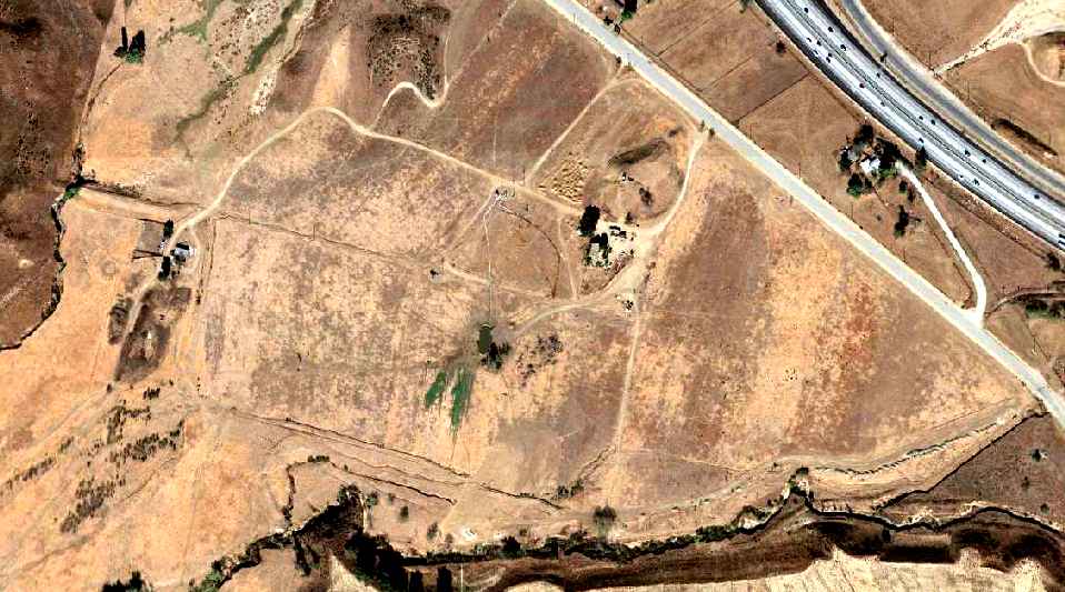
The 1996 USGS aerial photo of the site showed that the property had been redeveloped, and not a trace appeared to remain of the former airport.
A new road, Business Park Drive, had been built over the former runway area.
Chris Kennedy reported in 2003, "I have visited this site on the ground & found nothing."
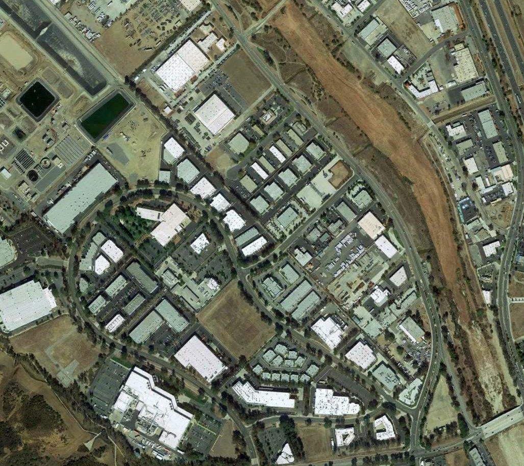
A 2016 aerial photo showed no trace remaining of Rancho California Airport.
The site of Rancho California Airport is located northwest of the intersection of Interstate 15 & Rancho California Road.
____________________________________________________
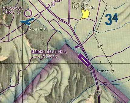
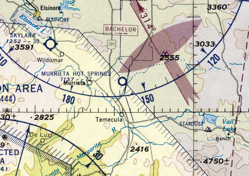
Murrieta Hot Springs Airport, Murrieta, CA
33.56, -117.193 (North of San Diego, CA)
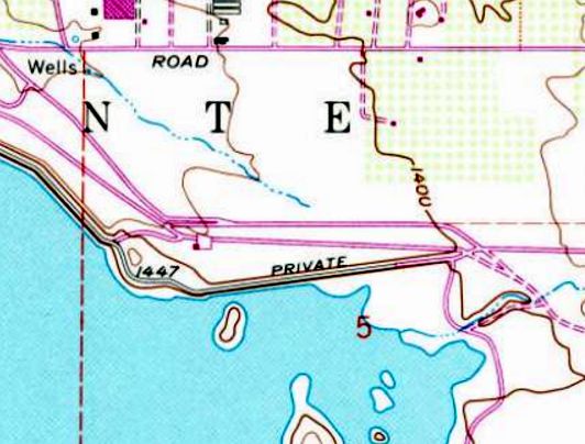
Murrietta Hot Springs Airport, as depicted on the March 1950 San Diego Sectional Chart.
This little airport was apparently opened at some point between 1949-50,
as it was not yet depicted on the September 1949 San Diego Sectional Chart.
The earliest depiction which has been located of Murrieta Hot Springs Airport
was on the March 1950 San Diego Sectional Chart.
It depicted Murrieta Hot Springs Airport as having an 2,200' unpaved runway.
Murrieta Hot Springs Airport was not yet depicted on the 1953 USGS topo map.
The last aeronautical chart depiction which has been located of Murrieta Hot Springs Airport was on the March 1960 San Diego Sectional Chart.
It depicted Murrieta Hot Springs Airport as having an unpaved 2,200' runway.
The 1962 AOPA Airport Directory described Murrieta Hot Springs Airport as having a single unpaved 2,200' Runway 9/27.
Murrieta Hot Springs Airport may have closed as a public airport by 1963,
as it was no longer depicted at all on the August 1963 San Diego Sectional Aeronautical Chart.
It was eventually replaced by the newly constructed Murrieta Temecula Airport, a few miles southeast.
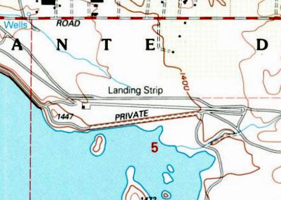
The earliest photo that has been located of the Murrieta Hot Springs Airport was a 1967 aerial view.
It depicted the field as having a single unpaved northeast/southwest runway.
A few small buildings were on the northwest side of the runway,
and 6 light aircraft were parked on the southeast side of the field.
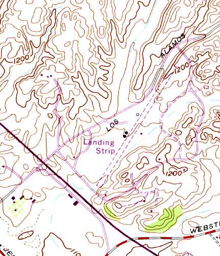
Murrieta Hot Springs Airport was labeled simply as "Landing Strip" on the 1973 USGS topo map.
It was depicted as having a single unpaved northeast/southwest runway,
with a few small buildings along the west side of the field.
The last photo which has been located showing the Murrieta Hot Springs Airport while in operation was a 1978 aerial view.
A single light aircraft was visible on the field.
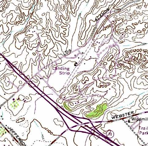
Murrieta Hot Springs Airport was labeled simply as "Landing Strip" on the 1979 USGS topo map.
It was depicted as having a single unpaved northeast/southwest runway,
with a few small buildings along the west side of the field.
Tom Kramer recalled, “When I used to drive up Interstate 15, if you knew just when to look,
you'd see a few aircraft parked there with a hangar or two.
I do recall seeing a large piston engine passenger type aircraft there back in the 1980s.”
Lane Leonard reported, “I flew into there only once from the Lake Riverside Airport.
The large aircraft was a 4-engine De Havilland Heron. Green & white with opposed engines & not Rangers.
The Heron was parked on the northwest corner of the airport & was visible from the freeway.
At that time I wondered about balanced field length with that type of aircraft.
Where the construction equipment is now located is where it was parked.
I never got to see it fly but one day driving by it looked like a large party of around 8 was preparing to board it.
It was there for about 6 months & then suddenly it was gone.”
A 1996 aerial view looking northwest showed the Murrieta Hot Springs Airport runway remained intact.
Ryan Martin reported, “I lived on Murrieta Hot Springs Airport from 1995-2018.
Around 1996-1997 there was a P-38 Lightning visiting for a few days & buzzing around the field.
The last time I remember seeing a fixed-wing plane operate out of there was probably 1999.
There have since still been a neighbor or two operating their helicopters out of there.
The last time I was physically on the field, I noticed there was a very large submarine being stored on it.
The submarine appeared to be a large tourist one, about the size of the type you see at Catalina but it was all white.
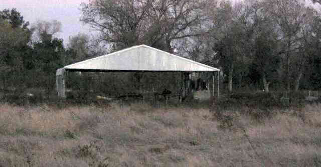
The last plane I flew out of there was a Beechcraft Baron, which was kept in the large hangar you see on your website.
Around the same time, there was a Cessna 182 operated out of the house on the very East tip of the runway.”
Chris Kennedy reported in 2003, "I went by the Murietta Hot Springs Airport
and it looks pretty much like the [above] aerial photo, although there are For Sale signs along the runway."
A Fall 2006 panoramic shot by Chris Davis of the Murietta Hot Springs Airport.
Chris observed, “the reason the airstrip V's is the distance from which I took the 180 degree shot (very close).”
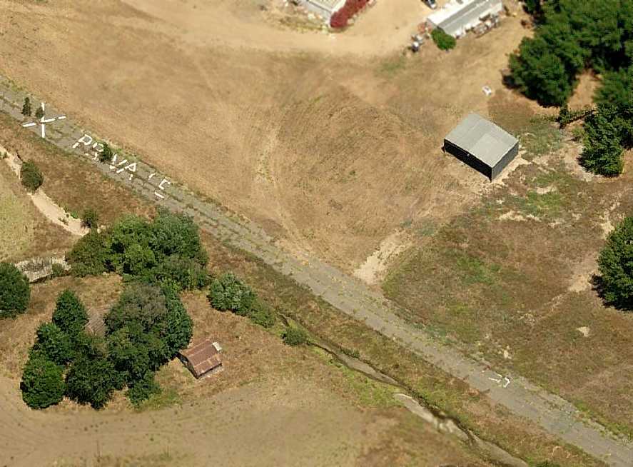
A circa 2007 aerial view looking east at the remains of the Murietta Hot Springs Airport,
showing the runway pavement still marked with “X Private” & a remaining hangar.
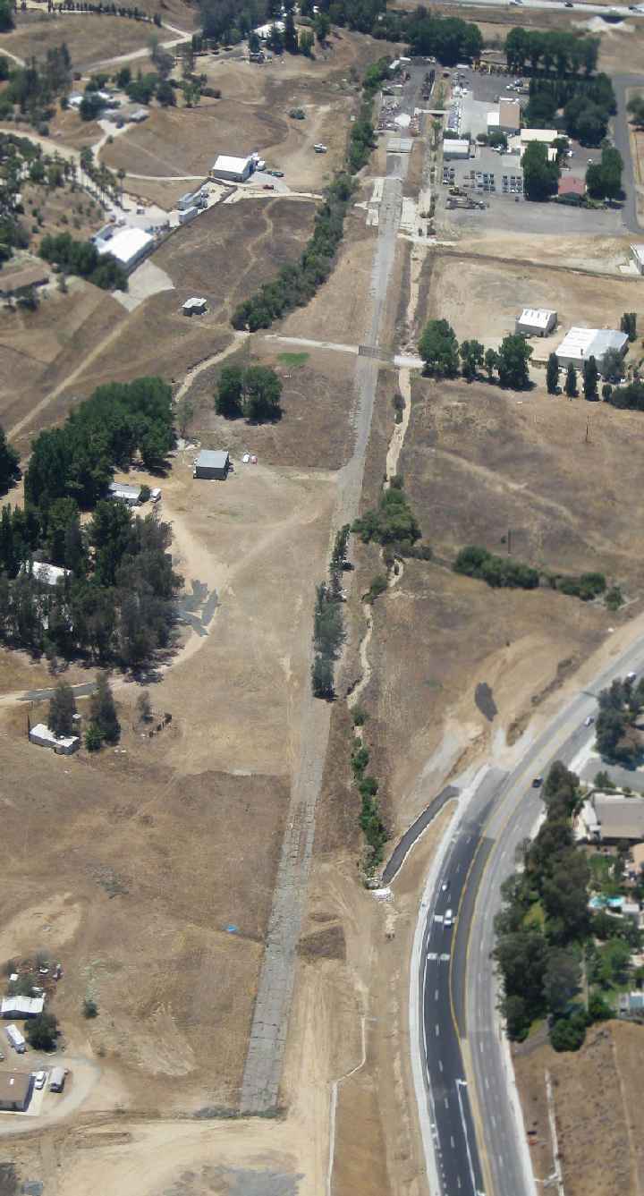
A July 2009 aerial view by Woodrow Anselen looking southeast along the remains of the Murrietta Hot Springs runway.
Woodrow reported, “Its a funny thing; I have been flying this same area for 36 years,
and was never even aware there existed a Murrietta Hot Springs Airport until I saw it on your website.
By using your descriptions I was able to locate it, and flew out there last week;
the airstrip is only some 12 minutes flying time from my home airport (Corona, CA).
The runway is still plainly visible & generally intact.
On the northeastern end, however, you can see some very substantial trees growing right through the pavement.”
A July 2009 aerial view by Woodrow Anselen looking west at the former hangars & runway at Murrietta Hot Springs.
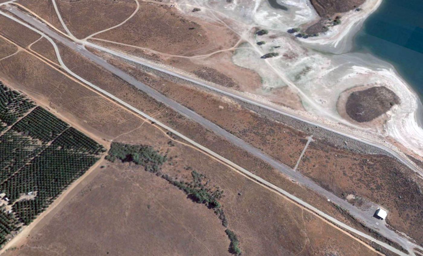
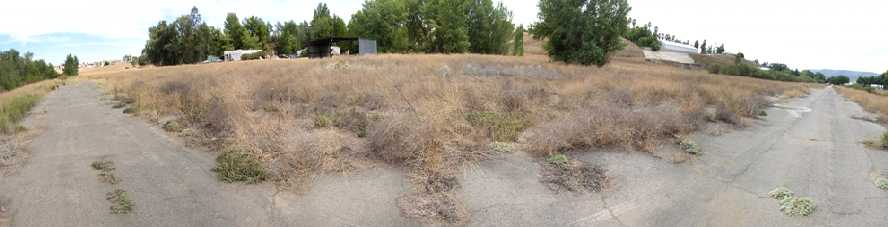
A 2016 aerial view looking northwest showed only a portion of the Murrieta Hot Springs Airport runway pavement remained intact.

A 2023 photo looking southwest along the site of the Murrieta Hot Springs Airport runway.
The Murrieta Hot Springs Airport site is located east of the intersection of Los Alamos Road & Monroe Avenue.
____________________________________________________
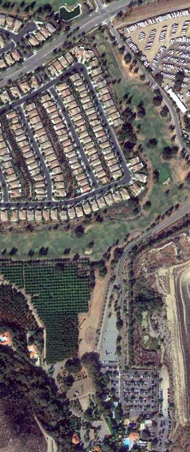
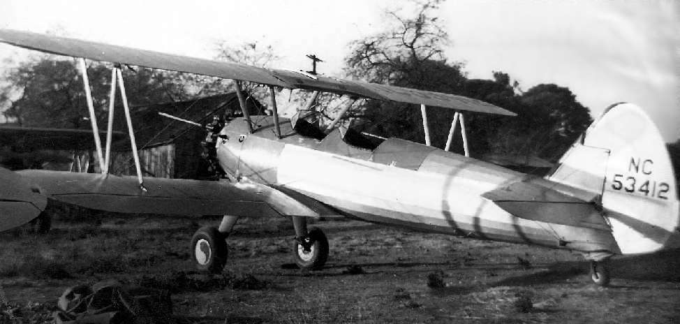
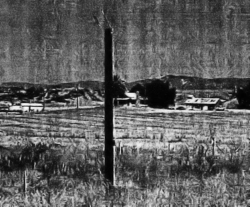
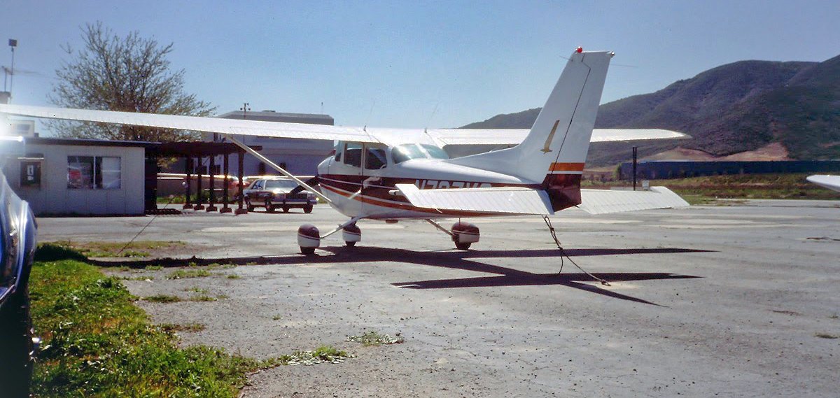
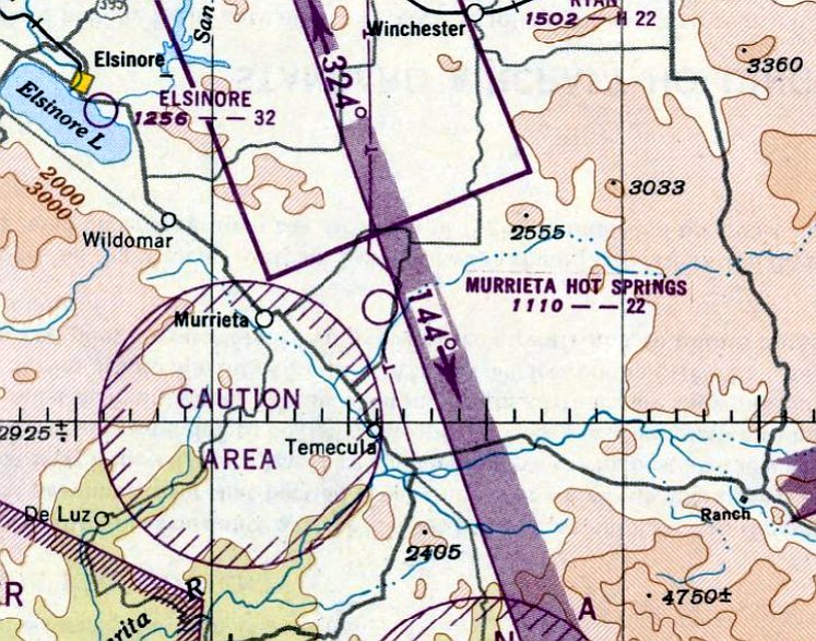
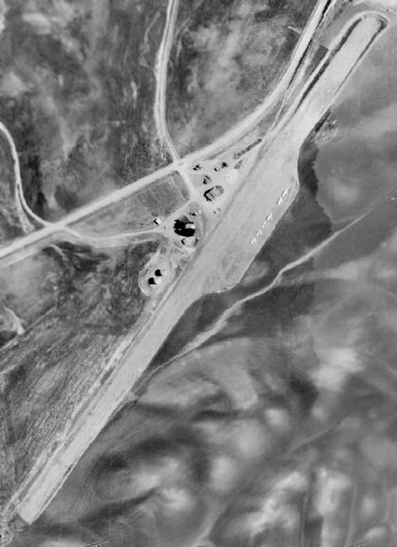
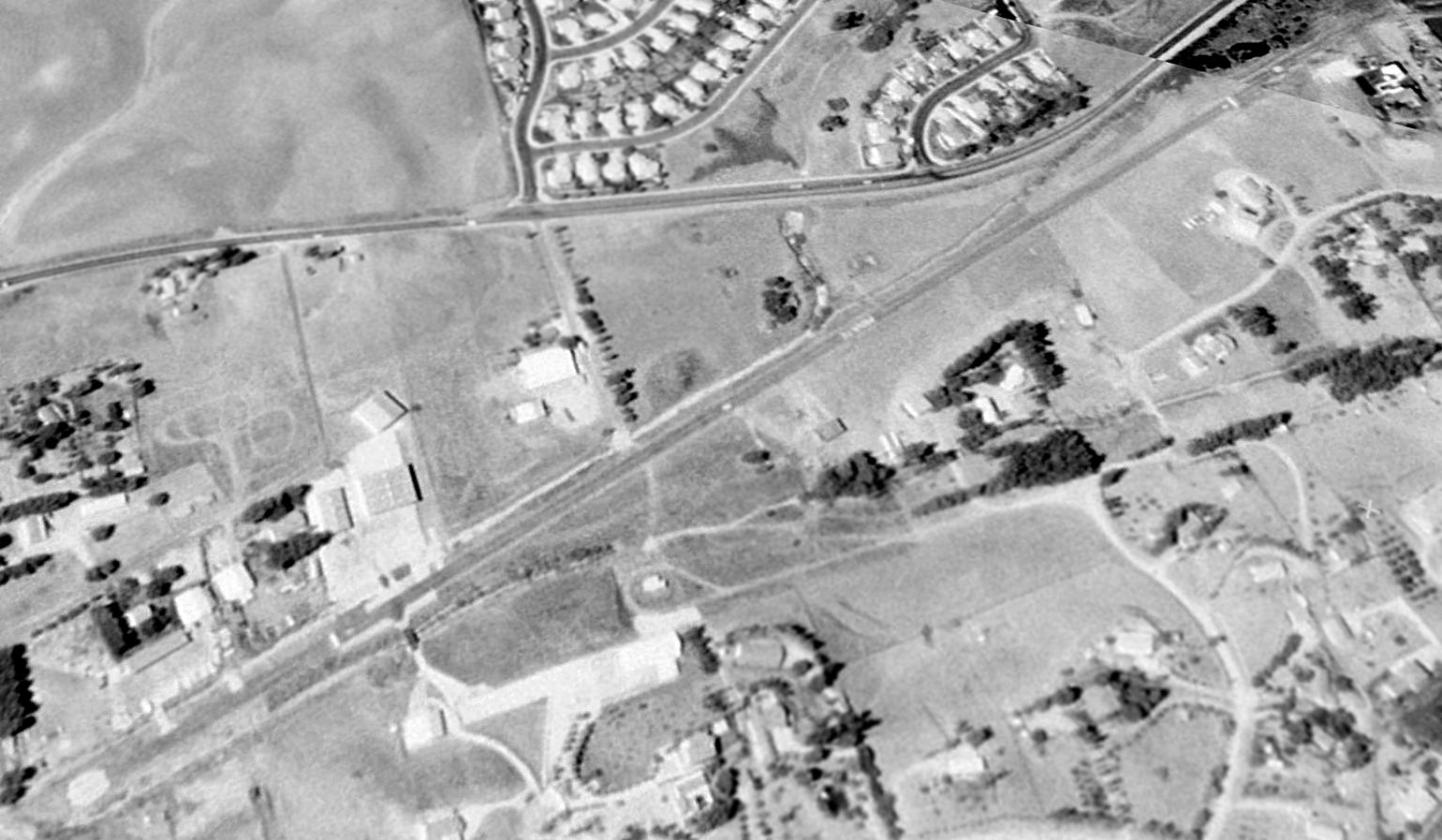
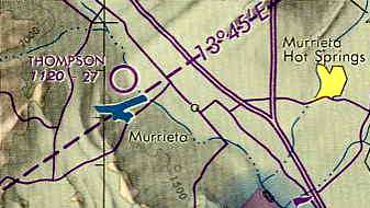
Thompson Field / Bear Creek Airport (L86), Murrieta, CA
33.57, -117.24 (North of San Diego, CA)
Thompson Field, as depicted on the January 1979 LA Sectional Chart (courtesy of Mitchell Hymowitz).
This general aviation airfield was apparently built at some point between 1967-78,
as it was not depicted on the 1966 San Diego Sectional Aeronautical Chart (courtesy of Chris Kennedy)
nor depicted on a 1967 aerial photo.
The earliest reference to the field which has been located
was in the 1978 Pilot's Guide to CA Airports (according to Chris Kennedy),
which listed it in the "Unattended Airports" section as the "Thompson Transportation Center".
It was described as having a single 2,700' dirt Runway 15/33.
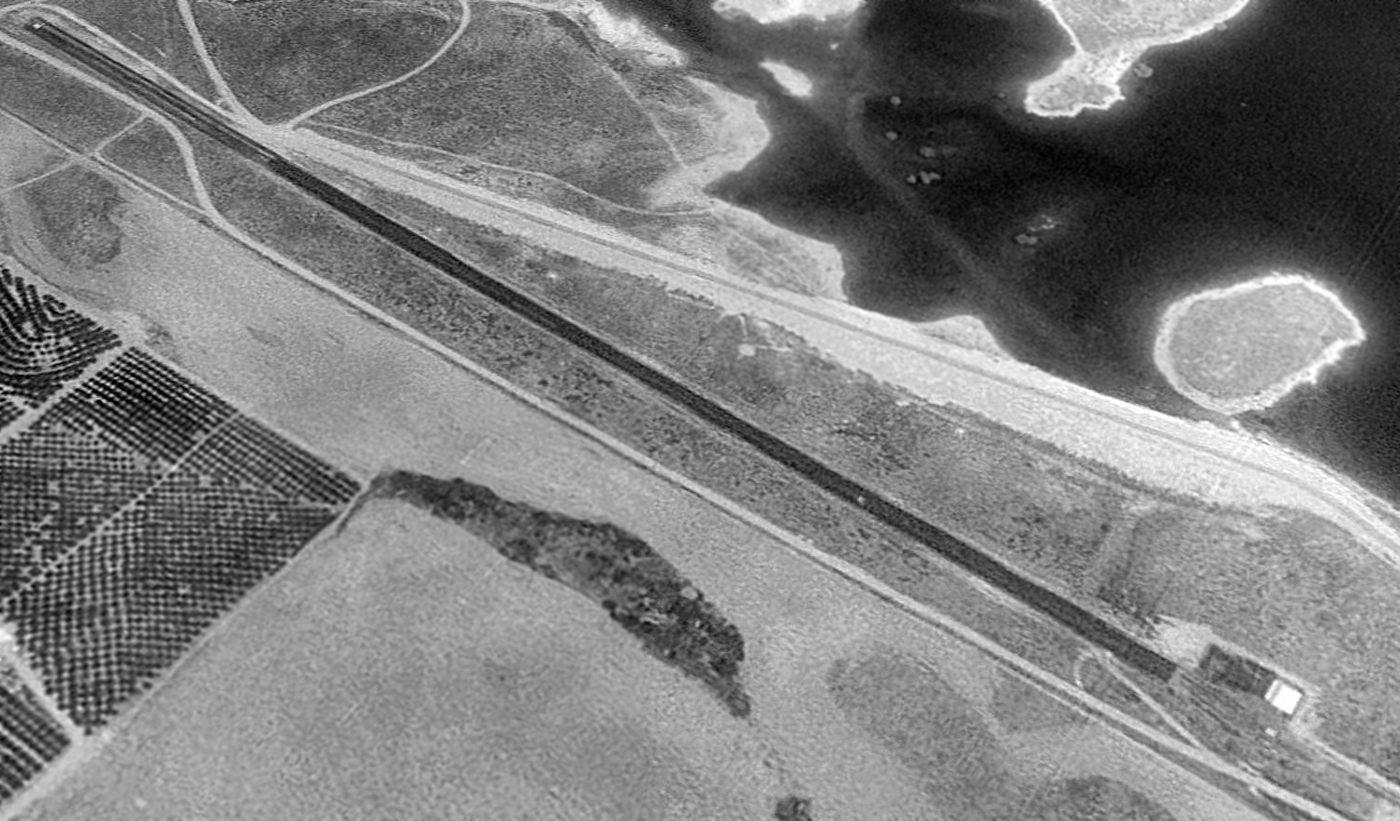
The earliest depiction which had been located of Thompson Field was a 1978 aerial photo.
It depicted the field as having a single unpaved northwest/southeast runway.
Two very small buildings were on the southeast side of the field, along with 4 light aircraft.
The earliest aeronautical chart depiction which has been located of Thompson Field
was on the January 1979 LA Sectional Chart (courtesy of Mitchell Hymowitz).
It depicted Thompson Field as having a 2,800' unpaved runway.
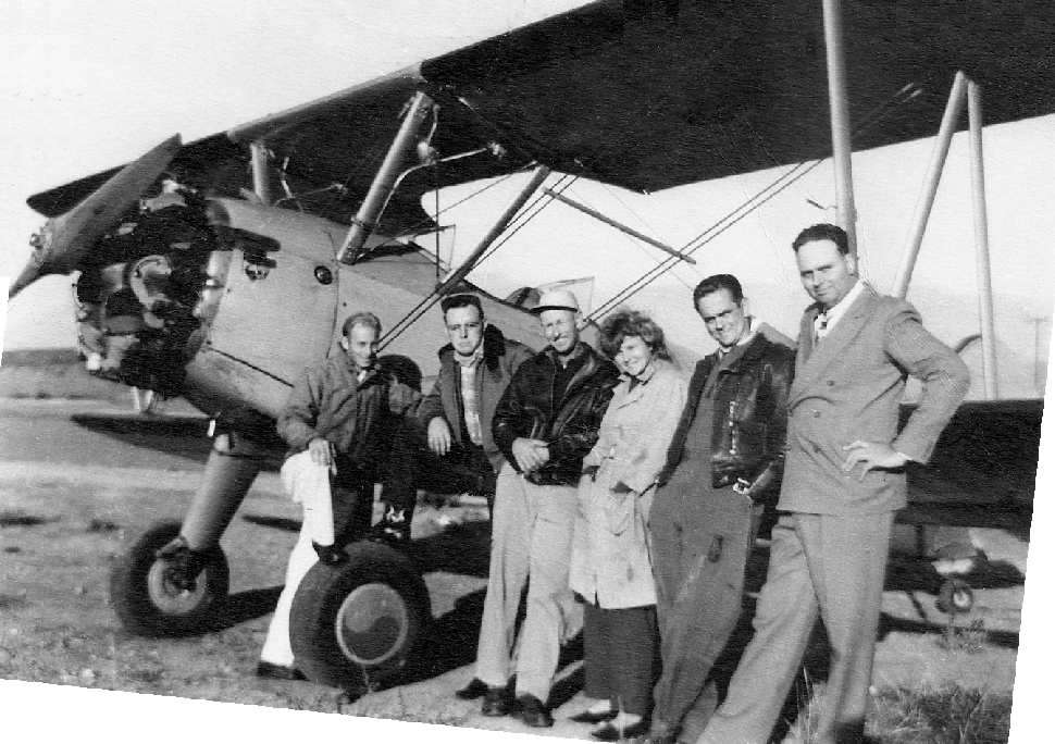
According to Bob Butt, "About Thompson Field - It was owned by Curt Thompson a local farmer.
Several of the farmers would come & sit in some old couches under the oak trees in the evenings & drink beer.
They had a pile about 5' high. The runway was surrounded by the wild wheat that Curt would harvest & bail as feed.
I did my early flight training there in a Taylorcraft & a C-140 & we would go to the Temecula airport for fuel.
When Skylark airport flooded, the skydiving operation moved there until the waters receded.
The DC-3's are still owned & operated by the same person, they are at Skylark (Elsinore).
The last one to fly out of there landed at Skylark & has not flown since."

A still from a 1979 video of a Cessna 152 taking off to test a banner tow mechanism.
Bob Cannon recalled, "Thompson Field… I did all of my test flying for my banner tow mechanism there.
I believe [the owner's] name was Carl. He offered me the entire property for $1M.
The new Jack Nicklaus golf course nearby ran a large paved road right up to mid-field where their property ended.
I think they fully intended to buy the property eventually. It was a fun place where one could also do some target shooting & have a picnic."
Eric Coleson recalled, “Arleen relocated her commercial glider operation to the Elsinore valley at Thompson Field in December of 1980.
The confined & challenging runway at Thompson accommodated less than 50 tows/day on the best days.
Curt Thompson & his buddies gathered about a campfire at the south end.
Curt owned a Cessna 140 that hadn't flown in recent years, and when the soaring operation opened at his airport, he offered a month of free rent if our mechanics got his airplane flying.
His buddies offered to pay our rent for 2 months if we didn't.
Between the forced decrease in volume, the cost of multiple relocations, and a generally declining economy, Arleen was forced to close the business at Thompson in September of 1982.”
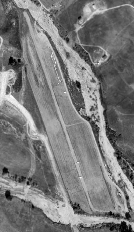
A 1982 aerial view depicted Thompson Field as having a single northwest/southeast runway.
A few very small buildings were on the southeast side of the field, and a total of 15 aircraft were visible on the field.
Eric Coleson observed, “Depicted in the aerial view are 4 Schweizer SGS2-33s, 2 SGS1-26s, a single SGS1-35C & SGS1-36, and 3 Let L-13 Blaniks being prepared by line crew for flight on a weekend morning.
On the runway are 2 Piper tow planes, a PA25-235hp Pawnee N6563Z & PA18-180hp SuperCub N7464L, taxiing out for the morning warmup flight.
A third PA18-180hp tow plane N9406P is tied down near the office & workshop.
South of the office, is a 300 gallon avgas bowser meant to limit refueling trips to Rancho California during operations.”
It was listed as "Thompson Transportation Center" in the 1982 AOPA Airport Directory (courtesy of Ed Drury),
with a single 2,800' dirt Runway 15/33, and the operator listed as Skylark Gliderport.
The July 1986 San Diego Terminal Aeronautical Chart (courtesy of Stu Sibitzky)
depicted Thompson Field as having a 2,700' unpaved runway.
In its last few years it was used for parachuting & ultralight aircraft operations.
Thompson Field was depicted as an active airfield on the 1989 San Diego Terminal Area Chart (courtesy of Chris Kennedy),
with a 2,700' unpaved runway.
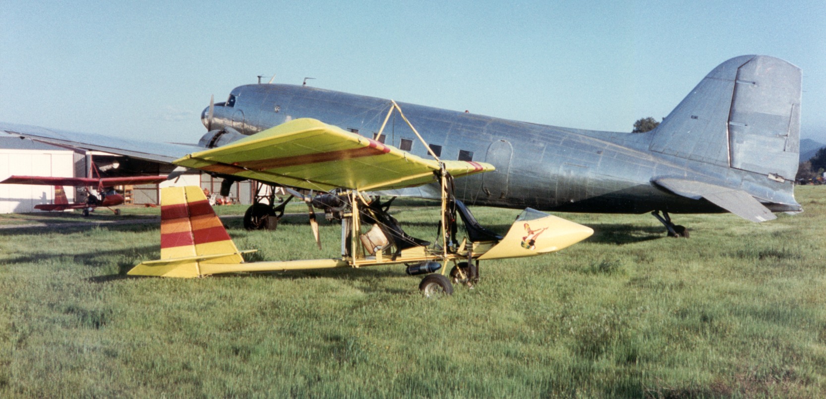
A circa 1990 by Brook Norton of his 2 Drifter ultralights (in which he did flight training) & an operational Douglas DC-3 at Bear Creek Airport.
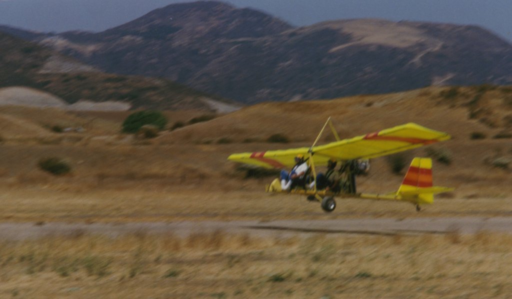
A circa 1992 (courtesy of Brook Norton) of a student & Brook Norton landing his Drifter ultralight at Bear Creek Airport.
Brook noted the photo shows “me training from the back seat, about to land (successfully) with just one front [landing gear] leg,
the other having broken off in a hard touch&go minutes before.”
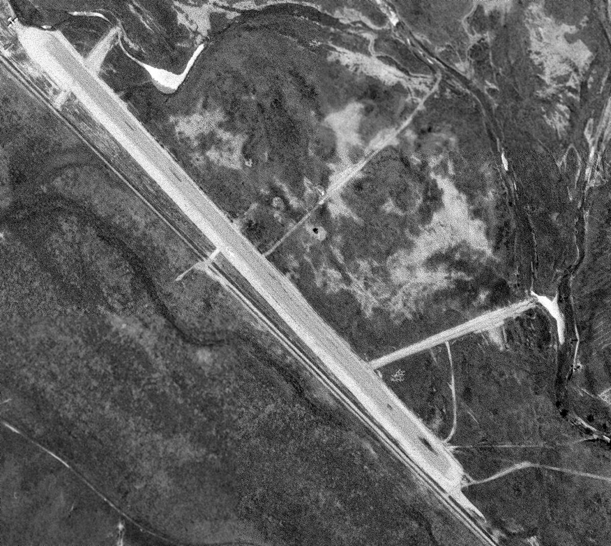
In a 1996 USGS aerial photo (enhanced by Bill Grasha), a total of 10 aircraft were visible parked outside, including three DC-3s!
One of those DC-3s was the last aircraft to fly out of the airport before its closure.
In addition to the single dirt runway, the airfield had several small buildings & hangars along the east side.
In its later years, the airfield was known as Bear Creek Airport.
Bear Creek Airport reportedly closed in 1997.
It had become surrounded by housing developments, which was most likely the reason for its closure.
The last aeronautical chart depiction which has been located of Bear Creek Airport was on the January 1998 LA Sectional Chart (courtesy of Ron Plante).
It depicted Bear Creek as a private airfield having a 2,700' unpaved runway.
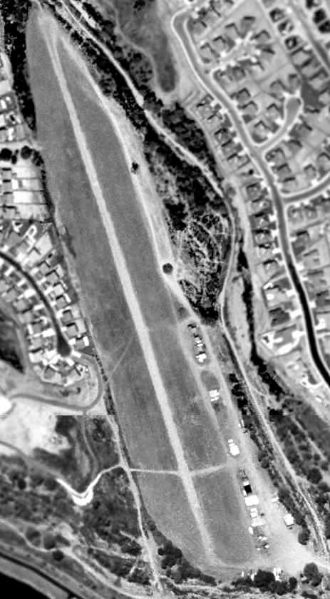
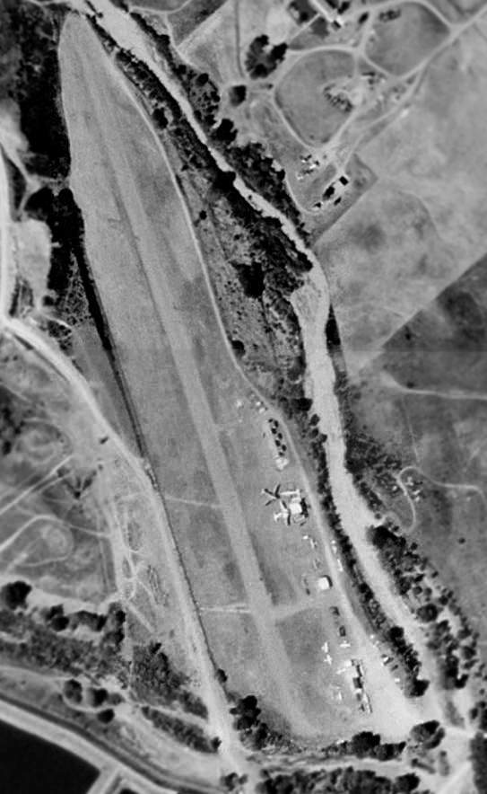
In the June 2002 USGS aerial photo (enhanced by Bill Grasha),
the Bear Creek Airport runway & airport buildings were still completely intact, just devoid of any aircraft.
Jere Vandewalle reported, “Aunt Lucy claims that as recently as 2002 (when she moved in) there were light aircraft operating there,
and since she saw lots of both kinds, I think she knows the distinction between those & ultralights.
There is still lots of traffic in the area & I wouldn't be surprised if landings continued after the closure for some time.”
According to Bob Butt, "Curt fought the city council over the construction of a bridge too close to the end of the runway
but although he won a judgment the bridge is still there.
When he died his brother did not have the strength to fight the city council
and sold it in 2002 or 2003 but it was actively in use by ultralights until the summer of 2003.
The post for the deposit of the landing fee is still there.
The buildings are being sold, dismantled, and moved."
Chris Kennedy reported in 2003, "I went by the Bear Creek Airport last week & it is still there, although fenced & inaccessible.
There are houses up to within a hundred yards or so of it to the east."
A 2005 photo by Chris Kennedy (enhanced by Bill Grasha), taken just west of the bridge, looking South-Southeast at the former Bear Creek Airport.
The runway is still visible, as well as one former hangar.
Anne Miller reported in 2005, “Any evidence of the old runway is 'fading away' & the site surrounded by new homes.
The high Calle Del Oso Oro bridge across the Murrieta Creek just off the north end of the runway virtually ended flying there.
The last DC-3 must been broken down & hauled out.”
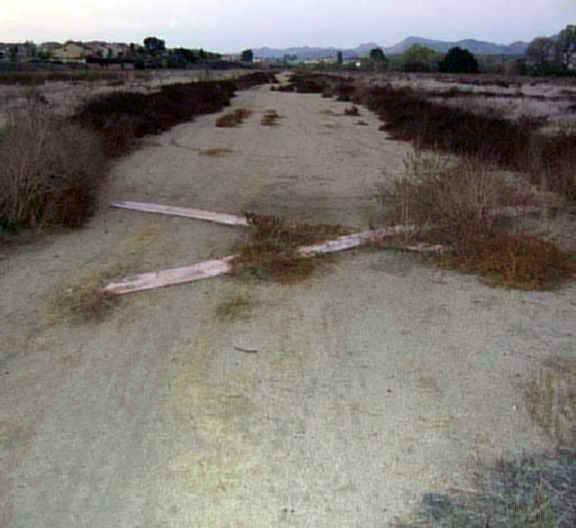
A 2005 photo by Jere Vandewalle (enhanced by Bill Grasha)looking along the remains of the former runway of Thompson Field.
Jere observed, “Standing on the runway it is hard to imagine DC-3s there.”
A 2005 photo by Jere Vandewalle (enhanced by Bill Grasha) looking east at the remains of a former hangar at the site of Thompson Field.
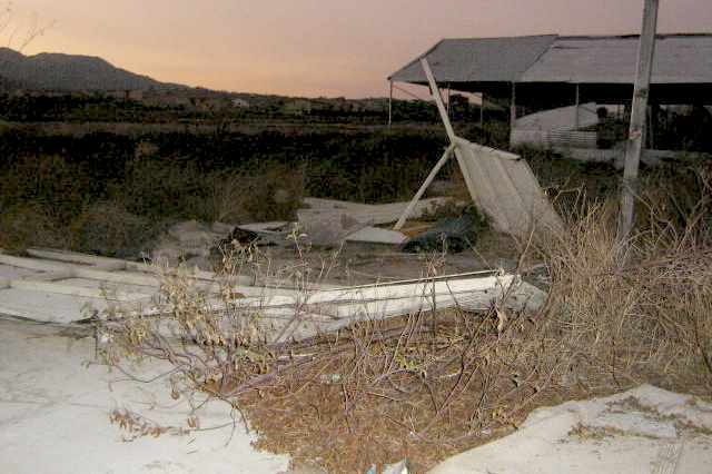
A 2005 photo by Jere Vandewalle looking northwest at ruins in front of a former hangar at the site of Thompson Field.

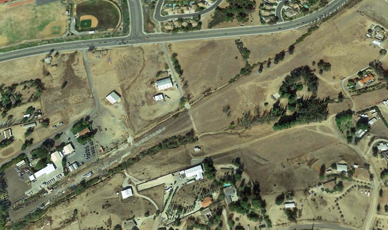
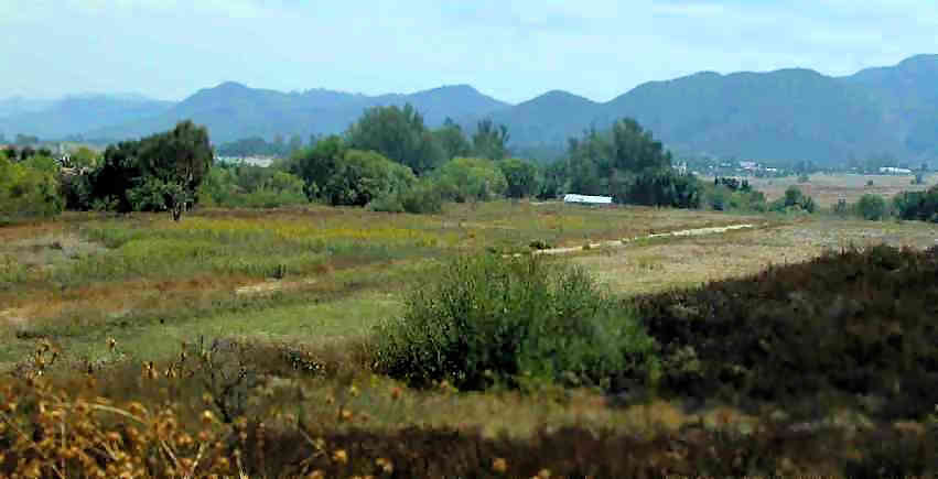
A July 2009 aerial view by Woodrow Anselen looking north along the remains of the Bear Creek runway.
Woodrow reported, “I used to see a number of airplanes on Bear Creek, and for a while there were even 2 DC-3s based there.
For reasons I cannot understand, I never flew out there & landed; funny thing for me, as the airstrip is only about a 12 minute flight from Corona.
In these pictures you can clearly see the runway, which again seems to be in serviceable, though perhaps not great, shape.
I certainly have landed on worse!
There are no buildings left, but you can still see the remnants of some concrete pads.”
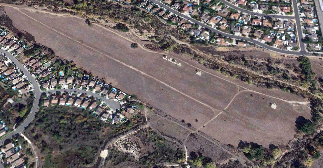
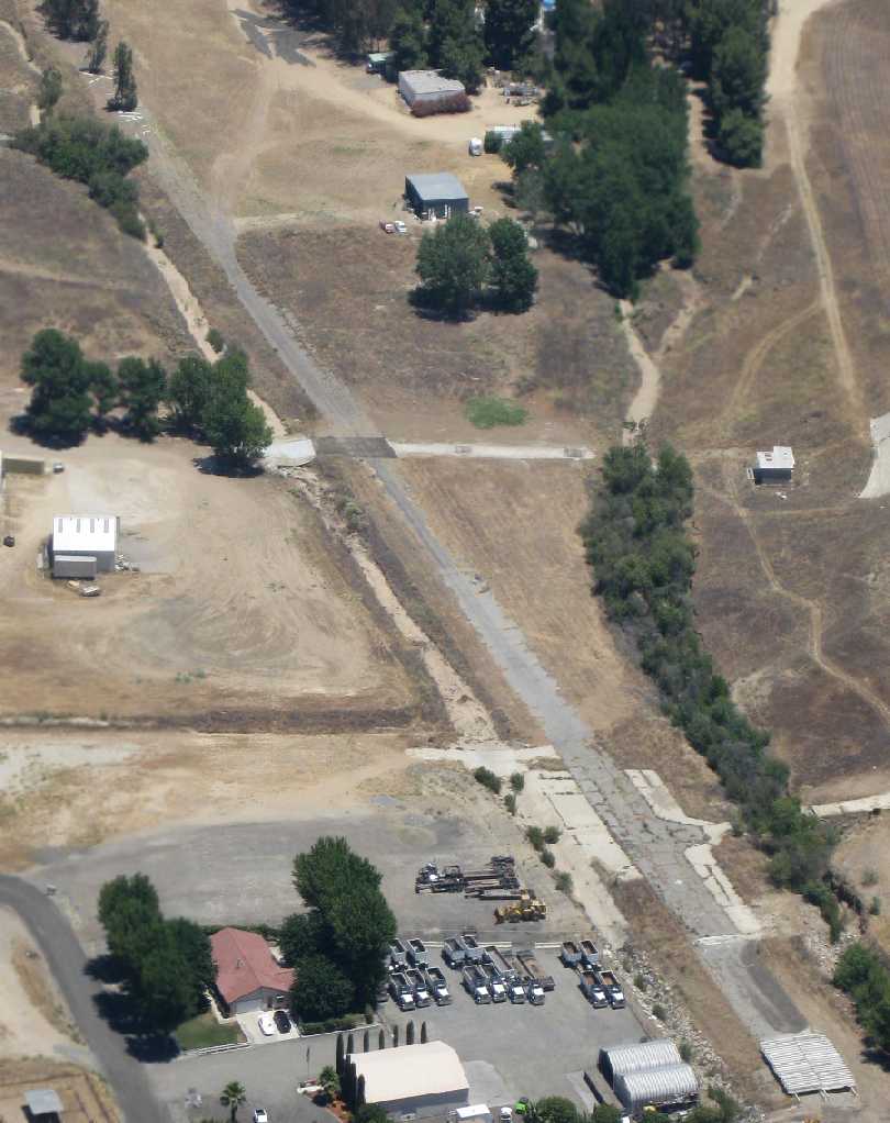
A 2018 aerial view looking northeast shows the remains of the Bear Creek Airport runway remains clear, along with the foundations of several hangars.
The site of Bear Creek Airport is located west of the intersection of Magnolia Street & Washington Avenue.
____________________________________________________
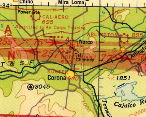
Norconian Club Airport, Norco, CA
33.93, -117.57 (East of Los Angeles, CA)
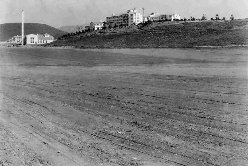
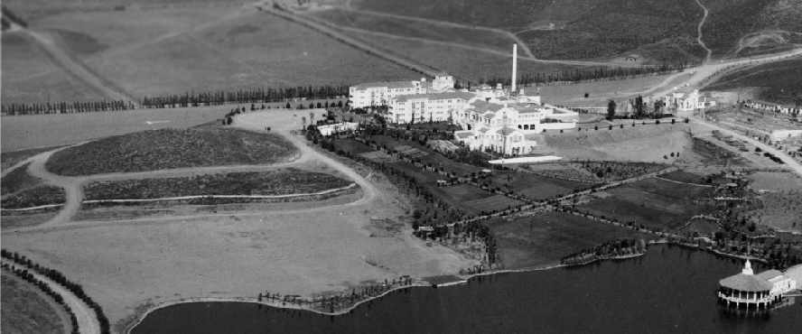
The Norconian Club, a 700-acre luxury resort, built by Rex Clark in 1928, was a playground for the rich & famous.
Frequented by silent-screen stars, the complex sported a gambling casino, golf course,
55 acre lake, a hot sulfur spring spa, a magnificent 5-story hotel, and its own airport.
Sitting atop a knoll, the hotel had a commanding view of Lake Norconian & the surrounding countryside.
The date of construction of the Norconian Club Airport has not been determined.
The earliest photo which has been located of the Norconian Club Airport was a 1928 photo,
showing a dirt runway with the club buildings in the background.
The earliest directory listing which has been located of the Norconian Lake Club Airfield
was in the Standard Oil Company's 1929 "Airplane Landing Fields of the Pacific West" (courtesy of Chris Kennedy).
It described the Norconian Lake Club Airfield as having 2 dirt runways, with the longest being a 2,400' east/west strip.
After the stock market crash of 1929, the Norconian resort plunged into a 12-year decline.
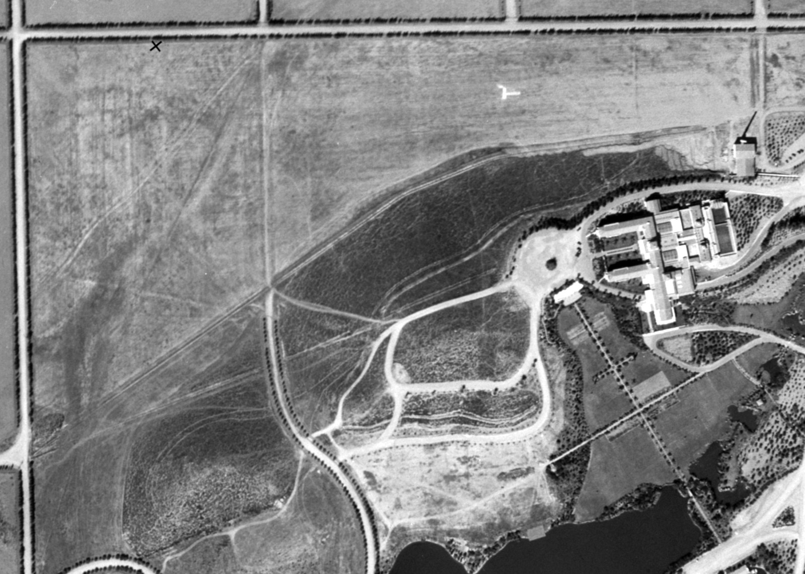
A 9/17/31 USGS aerial view depicted the Norconian Club Airfield as having an unpaved east/west runway (with an airfield “T” marking) to the north of the buildings,
and possibly 1 small hangar just south of the east end of the runway.
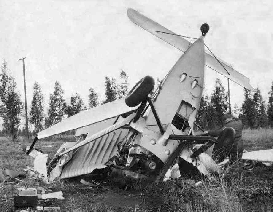
A 1/26/33 photo (enhanced by Bill Grasha) of the fatal crash of Marshal Boggs in an unidentified aircraft at the Lake Norconian Club.
Boggs, an inspector for the Civil Aeronautics Administration, was reported to be the 1st test pilot to use radio navigation.
In the 1930s, Will Rogers was reported to be a regular guest at the hotel, using the airfield to arrive & depart.
Amelia Earhart also used the Norconian air field to practice landings & takeoffs.
The earliest aeronautical chart depiction which has been located of the Norconian Club Airport was on the 1934 San Diego Airway Chart.
It depicted “Norconian Club” as an auxiliary airfield.
A 1936 Commerce Department "Descriptions of Airports & Landing Fields in the US" (courtesy of Dan MacPherson)
described the "Norconian Club Field" as having a single north/south sod 2,000' x 400' runway.
The Airport Directory Company's 1937 Airports Directory (courtesy of Bob Rambo) described Norconian Airfield in the same manner.
A 1938 aerial view depicted a single grass east/west runway on the northern side of the buildings.
It was still depicted as a commercial airfield on the 1939 LA Sectional Chart (courtesy of Jon Karkow).
The last aeronautical chart depiction which has been located of the Norconian Club Airport
was on the 1941 San Diego Sectional Chart (courtesy of Tim Zukas).
It depicted “Norconian” as a commercial/municipal airport.
Owner Rex Clark eventually agreed to sell the complex to the Navy for $1.6 million in 1941.
The posh former resort was transformed by the Navy into a Naval Hospital.
According to NSWC Corona public affairs journalist Marlowe Churchill,
the Corona “runway [was] used in the first aeromedical flights of WWII casualties.”
The Norconian Club Airport was evidently closed at some point between 1941-43,
as it was no longer depicted on the August 1943 San Diego Sectional Chart.
During WW2, some of the facilities at the Norconian also were used for early guided missile research.
The installation was eventually named the Corona Naval Weapons Center.
A 1948 aerial view showed that the site of the runway had been covered by buildings (most of which are still on the site as of 2005).
According to Troy Lyman, the site previously occupied by the Norconian airfield
was reused by the Navy in the to construct hospital overflow buildings to accommodate patients coming home from overseas.
These buildings were eventually reused as a prison, labeled the California Rehabilitation Center on topo maps.
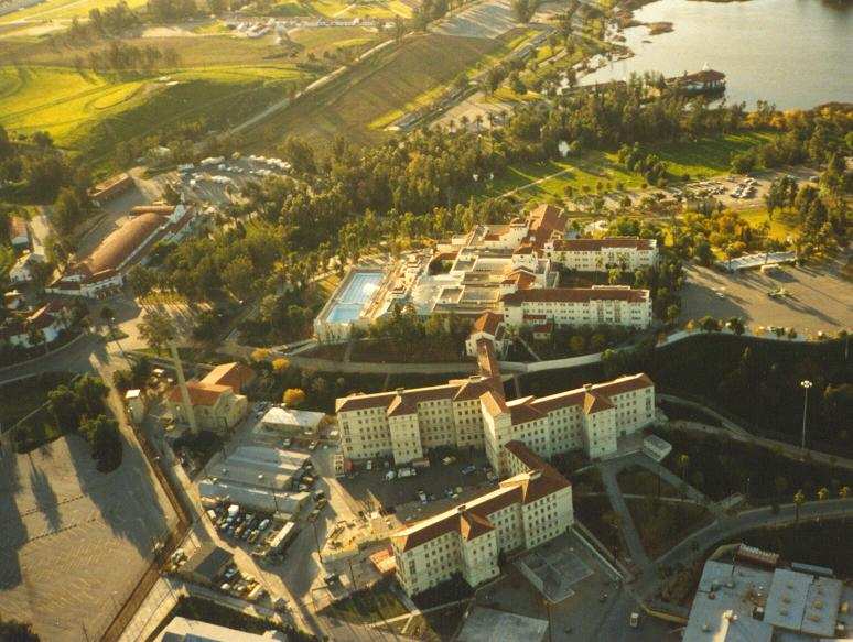
A 1985 aerial photo by Dan MacPherson looking south at the former Norconian Club.
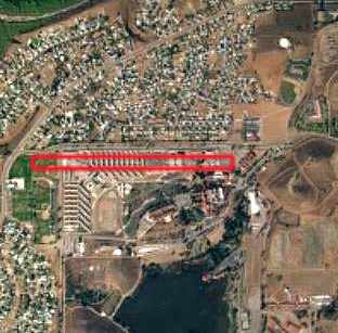
A circa 2001 aerial photo, annotated by Troy Lyman to show the location of the former Norconian Club runway.
No remains of the former airport were still perceptible.
Troy Lyman reported in 2005, “I have in our possession 2 photos showing the hotel & the old airfield.
The airfield was located just to the north of the hotel.
It would have been located just to the south of what is today 5th Street.”
In 2005, the Navy's Corona Naval Weapons Center was placed on the Base Realignment & Closure Commission list.
However, Tim Alsky reported in 2006 that “I'm happy to say that the Base Realignment & Closure Commission
decided last month that the Naval Surface Warfare Center will NOT be closed after all.
The historical site (former Norconian Club) was spared from the chopping block & will remain fully operational.”
____________________________________________________
____________________________________________________
This site covers airfields in all 50 states.