
Abandoned & Little-Known Airfields:
California: Southeastern Sacramento area
© 2002, © 2025 by Paul Freeman. Revised 6/10/25.
This site covers airfields in all 50 states: Click here for the site's main menu.
____________________________________________________
Please consider a financial contribution to support the continued growth & operation of this site.
For a 10th year, the CA pages of this website are sponsored by the California Pilots Association:
(Original) Calaveras County Airport (revised 9/12/23) - Rancho Zanjon Airfield / Madera #2 (revised 5/10/14)
Reed AAF (revised 6/10/25) - Sacramento Sky Ranch (revised 9/12/23)
Sharpe AAF (revised 8/11/19) - Skyline Airport / Perkins Airport (revised 7/9/21) - Sunset Skyranch / Elk Grove Airport (revised 6/10/25)
____________________________________________________
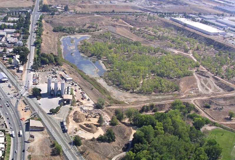
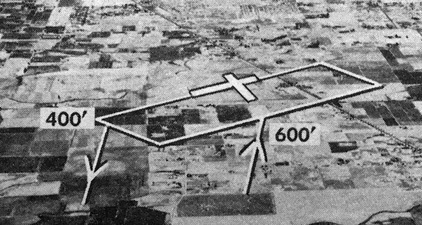
Sunset Skyranch / Elk Grove Airport (E27), Elk Grove, CA
38.396, -121.336 (Southeast of Sacramento Executive Airport, CA)
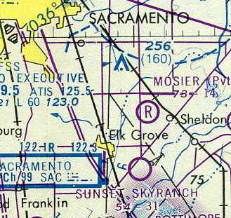
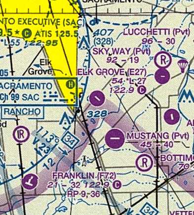
Sunset Skyranch, as depicted on the 1976 Sacramento Sectional Chart.
Yet another small general aviation airport lost to the forces of residential housing construction.
According to Mike Brown, “This facility had operated as an airport in some form or fashion since 1934.
The property was first used by Gus Windmiller to fly his glider from.
He & 2 friends would tow his glider behind a Model A Ford with a 300' cable.”
According to the book "Two Hours By Crow" by Howard & Judith Campbell (courtesy of Wings of History),
“Sunset Skyranch... was opened in 1936, closed by the U.S. Army in December of 1941, reopened in 1945.”
A 1957 aerial view depicted an open grass field with a house at the northwest end.
A 1964 aerial view depicted a few more buildings at the northwest end, including one possible hangar.
Elk Grove Airport was not yet depicted on the 1967 Sacramento Sectional Chart
nor on the 1970 USGS topo map.
According to Mike Brown, “The airport remained a dirt strip for mostly private use up until 1972.
The first Caltrans permit was obtained by the owner, Danny Lang, in 1972.”
The “activation date” listed in the FAA Airport/Facility Directory data for Elk Grove Airport was June 1972.
The earliest aeronautical depiction of the airfield which has been located was on the 1976 Sacramento Sectional Chart.
It depicted Sunset Skyranch as a public-use airfield having a 3,100' unpaved runway.
The 1977 USGS topo map depicted a single northwest/southeast runway, with a single building at the northwest end, but it was unlabeled.
According to Mike Brown, “There have been many improvements including a paved runway, about 40 hangars, and 40 tiedowns.”
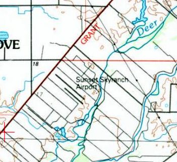
The 1993 USGS topo map depicted Sunset Skyranch Airport as having a northwest/southeast runway.
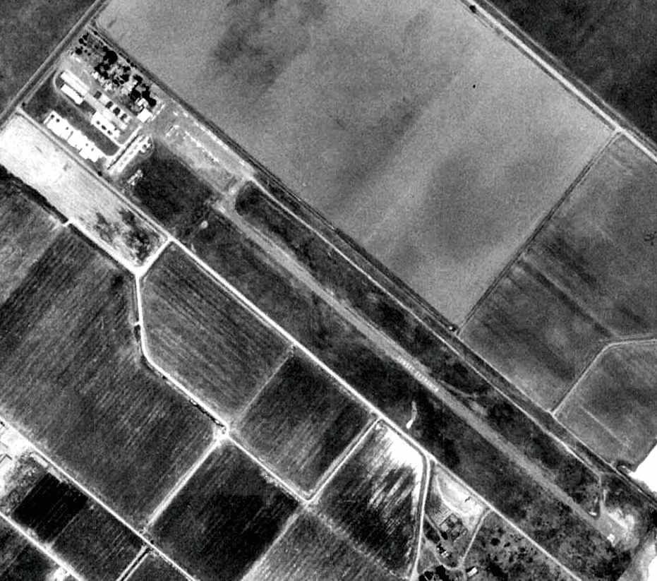
The earliest photo which has been located of Sunset Skyranch was a 5/23/93 USGS aerial view.
The airport had gained a paved runway at some point between 1976-93,
as it depicted the field as having a single northwest/southeast paved runway (painted with “Sunset Skyranch”)
and several small hangars & a good number of light aircraft at the northwest end.
Mike Brown reported, “Ironically the County supported us in 2000
when they were sued by the previous property owner over the county issuing us a use permit at that time.
A big developer here in Sacramento, Louie Pappas, purchased the property directly across the street in 2004.
The airport protective zoning was already in place with AG-5 (1 house on 5 acres agricultural) under our departure zone which effected 25 acres.
If the airport 'went away' he can rezone to RD-5 (5 houses per acre) and up the housing density from 5 to 125.
In 2005 the county refused to renew the conditional use permit.
This was followed by 5 years of litigation between the Sunset Skyranch Pilots Association & the County of Sacramento.
Ultimately the County prevailed.”

A 2004 diagram of Sunset Skyranch from the book "Two Hours By Crow" by Howard & Judith Campbell (courtesy of Wings of History).
The book described Sunset Skyranch: “There were two runways, but the dirt 1,900' one was a bit hard to see from the air. It was just mowed grass, but so is the entire perimeter inside the property fences.
The paved strip is 2,780' long & 35' of crowned pavement. The few times we have been in there we had a pretty good crosswind
and once there was a helicopter practicing its hovering just off the pavement on the northeast side, leaving little room for error.”
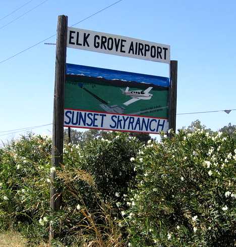
An 8/30/05 photo of the Elk Grove Airport sign.
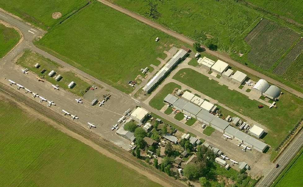
A circa 2005-2010 aerial view looking south at the hangars & aircraft at Elk Grove.
According to Dann Shively, “In 2006... the airport was close to closing.
Because of the slowdown in housing construction it held on for a few more years.”
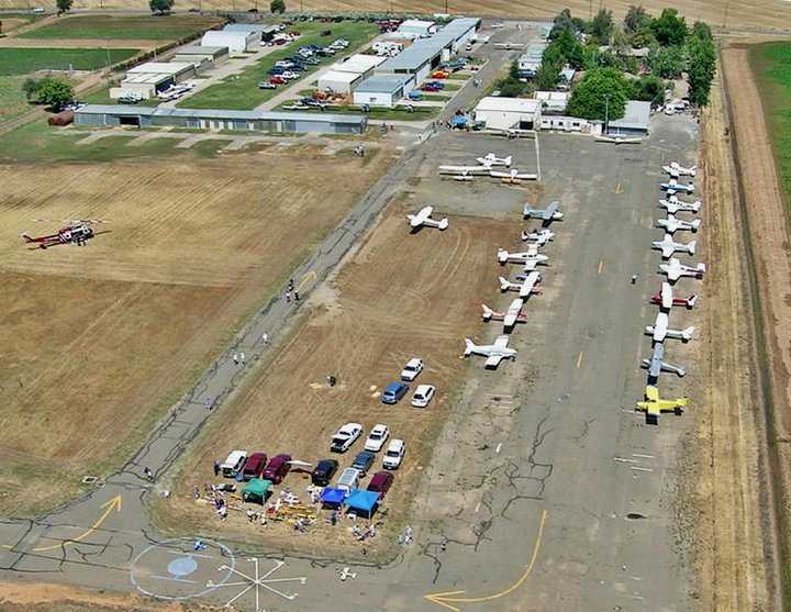
A 6/27/09 aerial view looking northwest at an open house held at Elk Grove Airport.
Note the Sacramento Metro Bell UH-1 helicopter at right.
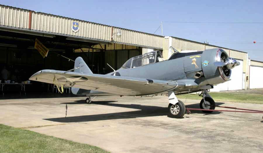
A 6/27/09 photo of a beautiful North American SNJ Texan in front of a hangar at Elk Grove Airport.
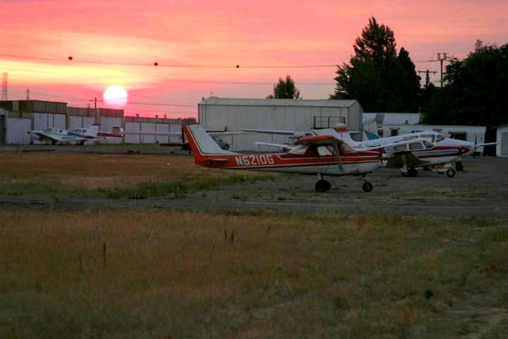
An undated photo of sunset at Sunset Skyranch.
The last photo which has been located showing Elk Grove Airport still in operation was a 4/7/10 aerial view looking southeast.
The 2010 San Francisco Sectional Chart depicted Elk Grove Airport as having a single northwest/southeast paved 2,700' runway.
In its last year of operation (2010), Elk Grove Airport's FAA Airport/Facility Directory data
described the field as having a single 2,769' asphalt Runway 11/29.
The owner was listed as Daniel Lang, and the manager as William Schimandle.
The field was said to have a total of 64 based aircraft, and to conduct an average of 23 takeoffs or landings per week.
Mike Brown reported, “Effective 7/1/10 the Elk Grove Sunset Skyranch has been closed by order of the Sacramento County Board of Supervisors.
Reason for not renewing the use permit?
Use is no longer compatible with encroaching development to the north within the boundaries of the City of Elk Grove.
It was a long hard fight for us. We had good community support.
Elk Grove was going through wild residential development at the time.
Most citizens appreciated the fact that the airport would reduce the number of houses that could go in down there.
The board of supervisors acknowledged they had received nearly 400 emails supporting the airport. We had about 50 at the last hearing.
Being that we are in the county we are represented by one of 5 county supervisors. The vote was 4-1.
They didn't cite a current reason, only that development was moving that way & the airport had become incompatible with the surrounding development.
Developer money talks here. It's all about profits from high-density housing development.”
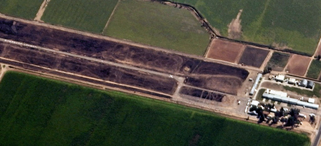
A 9/19/10 aerial photo (courtesy of Dallam Oliver-Lee) depicted closed-runway “X” symbols painted on both runway ends,
but at least 4 aircraft were still visible on the field.
Mike Brown reported in December 2010, “Some of us are still out there but there is no flying going on.
A few of the hangars have been moved off the property already.”
In the words of www.elkgroveairport.org, “The Elk Grove Airport has provided a public service for over 60 years without receiving any government aid or taxes.
Now local government wants to shut down the airport for more Elk Grove development.”
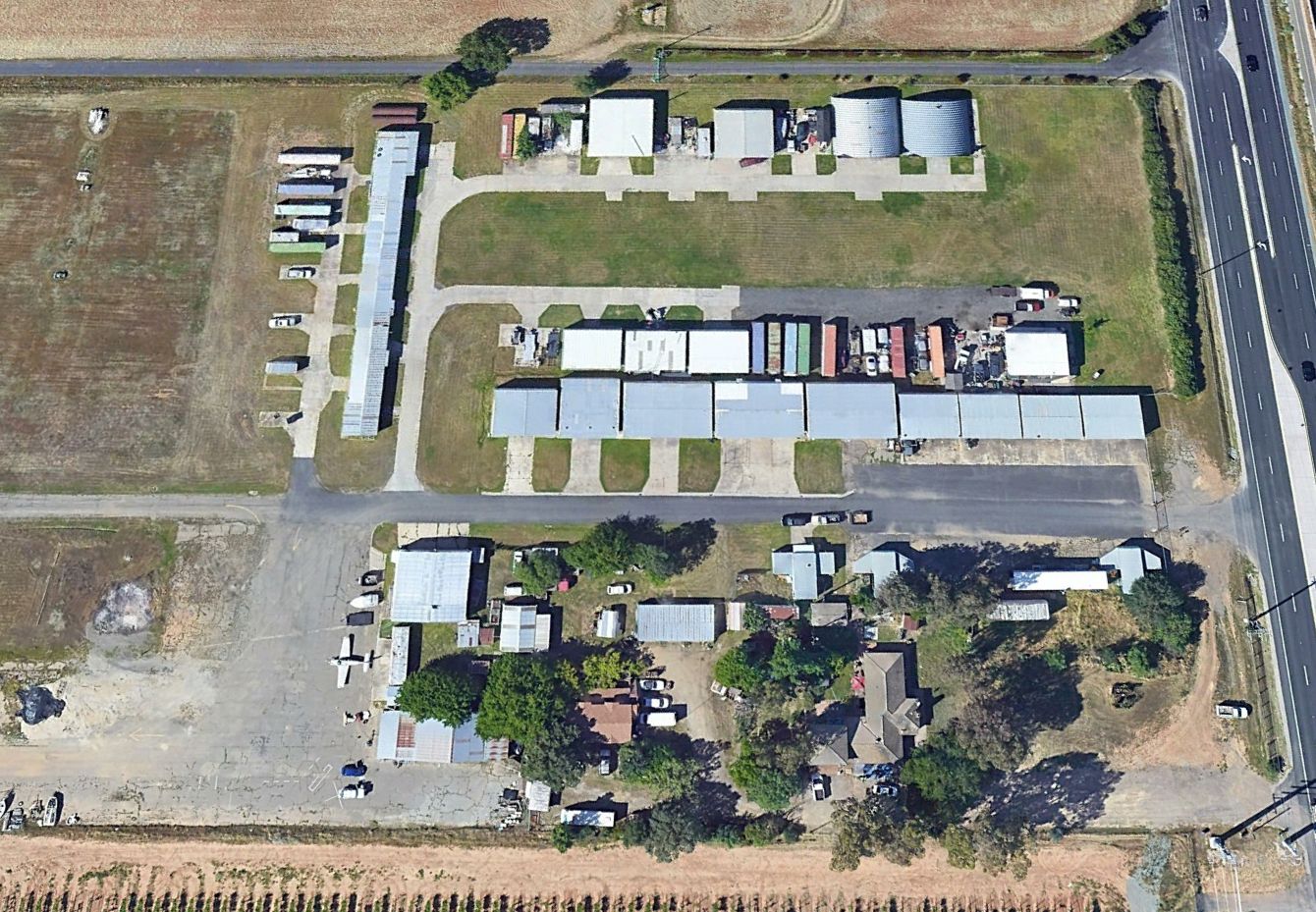
A 7/31/13 aerial view by Dallam Oliver-Lee (enhanced by Bill Grasha) looking southwest at Sunset Skyranch / Elk Grove Airport.
Dallam observed, “I saw parked aircraft [at least 3] outside the hangars & white X'd runways.”
Mike Brown explained the “burnt-out field on the airport property...
The Association & property owner continue to support our local fire district by allowing the former airport property to be used for brush fire training early each summer.”
Elk Grove Airport was no longer depicted on the August 2016 San Francisco Sectional Chart.
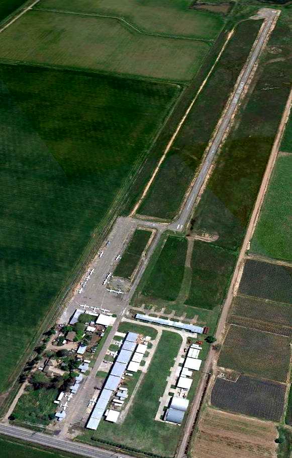
A 2022 aerial looking southwest showed 1 light single-engine plane remaining at Elk Grove Airport more than a dozen years after the airport's closure.
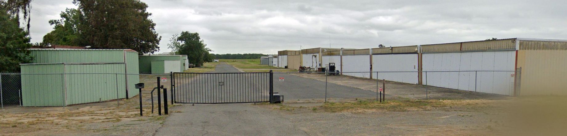
A 2023 photo looking southeast at the Elk Grove Airport hangars.
Elk Grove Airport is located south of the intersection of Grant Line Road & Bradshaw Road.
See also:
http://www.elkgroveairport.org/
http://www.facebook.com/pages/SAVE-THE-ELK-GROVE-AIRPORT/117731754912730
____________________________________________________
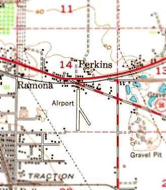
Skyline Airport / Perkins Airport, Perkins, CA
38.54, -121.39 (Southeast of Sacramento, CA)
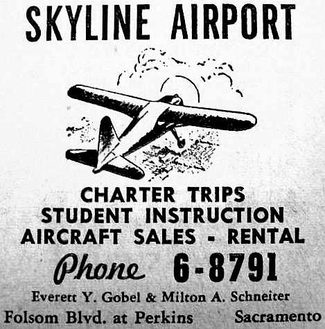
A March 1947 telephone book advertisement for the Skyline Airport (courtesy of Dann Shively).
According to Dann Shively, "The community of Perkins was a dot on the map that was consumed by Sacramento.
But it did have its own little strip.
It was located on the south side of Jackson Road just south &slightly east of the intersection with Folsom Boulevard."
The earliest reference to Skyline Airport which has been located
was an advertisement for the airport in a March 1947 telephone book (courtesy of Dann Shively).
The field was described as offering charter, student instruction, aircraft sales, and rental.
The operators were listed as Everett Gobel & Milton Schneiter.
Elaine McKim reported, “I am the widow of Everett Gobel. Everett was a stunt pilot. A group of the fellows started doing air shows.
I have a program for one of the shows they did at Perkins & a ticket or admission.
There was a house & barn on the property. The house was our office. We converted the barn to maintenance, and the loft into a party room.
Saturday night was party night, we had pot luck dinners & danced to a music from a record player. Very primitive but lots of fun.”
Skyline Airport was was not depicted on the 1947 USGS topo map.
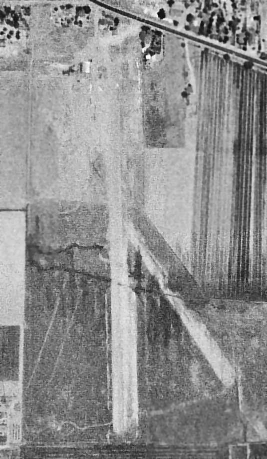
An 8/5/47 USGS aerial photo depicted Skyline Airport as having 2 unpaved runways.
A total of 8 light aircraft were visible parked near a single small building on the north side of the field.
Skyline Airport was was not depicted on the February 1948 Sacramento Sectional Chart.
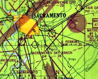
The field was apparently renamed "Perkins" Airport at some point between 1947-48,
as that is how it was labeled on the August 1948 Sacramento Sectional Chart (courtesy of Jonathan Westerling).
The chart depicted Perkins as having a 2,100' unpaved runway.
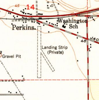
The 1949 USGS topo map depicted 2 unpaved runways, labeled “Landing strip (private)”.
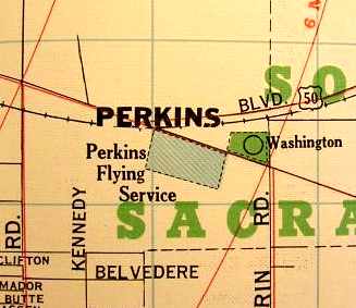
"Perkins Flying Service" was depicted on a 1950 street map (courtesy of Dann Shively)
as a rectangular property running northwest/southeast along the south side of Jackson Road.
The last aeronautical chart depiction which has been located of Perkins Airport was on the September 1953 Sacramento Sectional Chart.
It depicted Perkins as having a 2,300' unpaved runway.
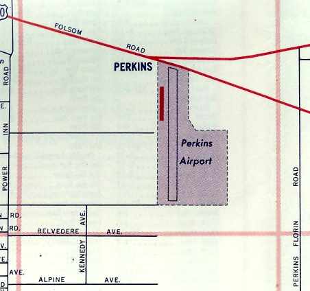
The depiction of Perkins Airport was quite different on a 1954 street map (courtesy of Crutiss Carroll):
it depicted the field as consisting of a single north/south runway, with a single hangar along the east side,
contained within a property largely running north/south.
The 1954 USGS topo map depicted Perkins Airport as having a north/south runway along with a shorter northwest/southeast taxiway.
Perkins Airport was apparently pretty short-lived, lasting no more than 9 years.
It was evidently closed at some point between 1953-54, as it was no longer depicted on the March 1954 USAF Sacramento Sectional Chart (courtesy of Chris Kennedy).
A 1957 aerial photo did not show any recognizable trace of Perkins Airport,
with the location of the runways apparently having been converted back to farmland.
A 2003 aerial photo by Dann Shively, looking east at the site of Perkins Airport.
"Folsom Boulevard is the main road veering off to the left. The road straight ahead is Jackson Road.
The airport was located just to the right (south) of Jackson Road."
According to Dann Shively, "That whole area now is just a huge gravel pit owned by the Teichert Company.
Obviously nothing is left of the airport. There was a golf course there as well that disappeared when the mining started."
____________________________________________________
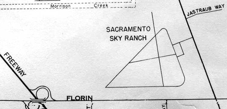
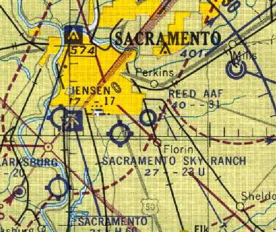
Sacramento Sky Ranch, Sacramento, CA
38.5, -121.43 (Southeast of Sacramento Executive Airport, CA)
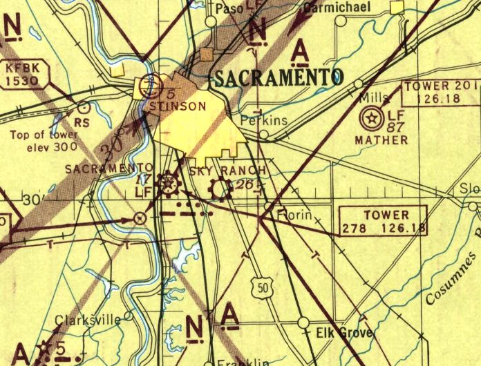
Sacramento Sky Ranch, as depicted on the May 1945 Sacramento Sectional Chart.
Sacramento Sky Ranch was evidently built at some point between 1944-45,
as it was not yet depicted on the December 1944 Sacramento Sectional Chart
nor listed among active airfields in the 1945 AAF Airfield Directory (courtesy of Scott Murdock).
The earliest depiction which has been located of Sacramento Sky Ranch was on the May 1945 Sacramento Sectional Chart,
which depicted it as a commercial/municipal airport.
According to Dann Shively, Sacramento Sky Ranch was owned & operated by John Schwaner, starting just after World War 2.
John Schwaner was an Aeronca distributor & sold aircraft parts, supplies, and services.
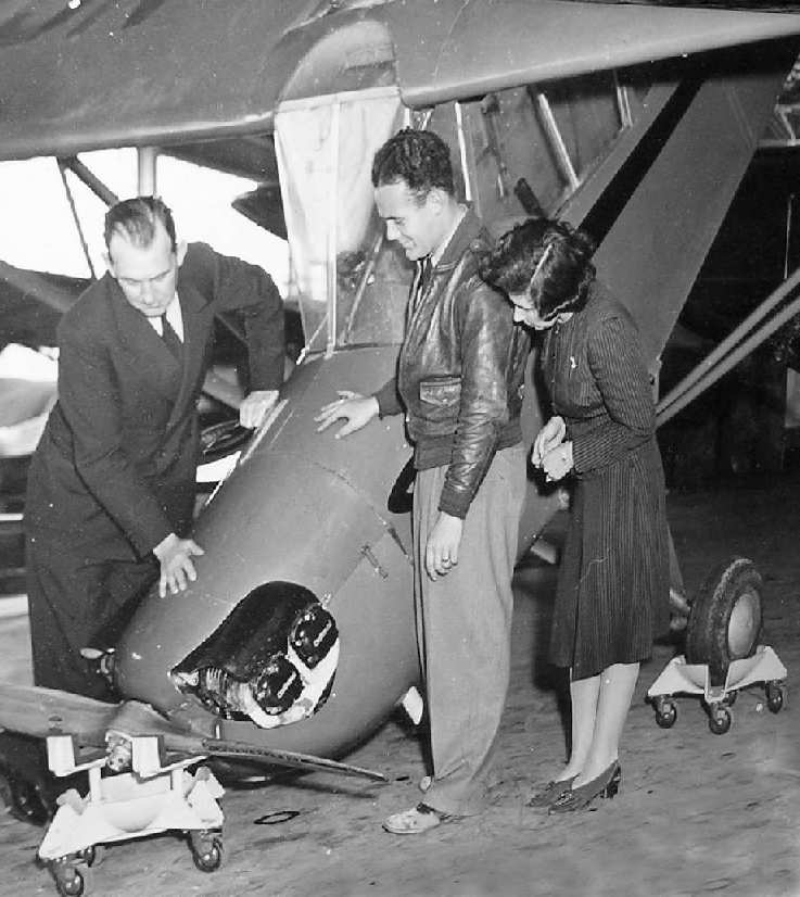
A circa 1940s photo of John Schwaner, showing his invention for moving & storing airplanes on their nose (used by permission of John Schwaner, via Dann Shively).
Instead of being flown to Sacramento from the Aeronca factory, planes were partially disassembled & shipped by rail.
John Schwaner also invented a unique way of storing aircraft by setting the wheels & propeller in dollies & stacking them with their tails elevated.
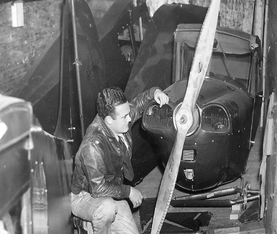
A circa 1940s photo of John Schwaner kneeling in front of a plane within a railroad car (used by permission of John Schwaner, via Dann Shively).
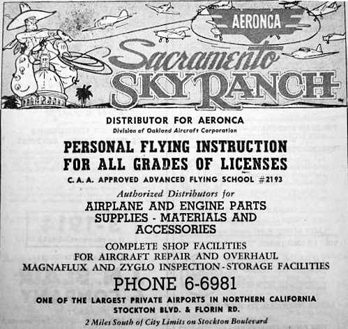
An advertisement for Sacramento Sky Ranch in a June 1946 telephone directory (courtesy of Dann Shively)
described the field as being an Aeronca distributor, and offering flight instruction, parts, supplies, repair.
It also described the field as "One of the largest private airports in Northern CA."
According to the book "Two Hours By Crow" by Howard & Judith Campbell (courtesy of Wings of History),
“There was a 102' x 80' steel building that was both hangar & maintenance shop erected in 1946.”
A 1947 Chamber of Commerce street map (courtesy of Kevin Walsh) depicted Sacramento Sky Ranch as a property outline.
The 1948 Sacramento Sectional Chart (courtesy of Jonathan Westerling) depicted Sacramento Sky Ranch as having a 2,800' unpaved runway.
According to the book "Two Hours By Crow" by Howard & Judith Campbell (courtesy of Wings of History),
“Being the Aeronca Dealer helped a lot & other airport managers came to buy their new planes here.
In fact, the Sky Ranch was doing so well the factory asked them to host the 3/10/48 Aeronca Distributor's Meeting & used it to introduce the new Aeronca 15AC Sedan.
This plane could be had in any color you wanted as long as it was red & orange or green & white. The Sky Ranch was also the distributor for Edo Floats.
We guess it won't come as a surprise that the new Sedan could be had with Edo 89-2000 floats as a factory installation.
The interesting part of this deal was how you got your plane. The airplane would arrive by rail & be trucked to the Sky Ranch, where they would put on the floats in their maintenance hangar.
This new floatplane was then set down on a special wheeled dolly. Delivery was by taking off on the dolly & just flying off it, so the new plane could be flown to its new owner onto his piece of water.
The dolly rolled on down the runway & then was returned to the hangar for the next delivery.”
The 1949 Sacramento Sectional Chart (courtesy of Chris Kennedy)
continued to describe Sacramento Sky Ranch as having a 2,800' unpaved runway.
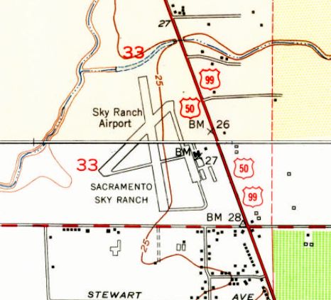
The 1949 USGS topo map depicted “Sky Ranch Airport” / “Sacramento Sky Ranch” as having 2 runways.
An undated aerial view looking north at Sacramento Sky Ranch from the 1950 Air Photo Guide (courtesy of Kevin Walsh).
It described Sacramento Sky Ranch as having 2 runways: 2,800' Runway 2/20 & 2,400' Runway 15/33, and listed the manager as John Schwaner.
A 10/4/52 aerial view (from the UCSB Librart) depicted Sacramento Sky Ranch as having 2 runways & multiple taxiways,
with several light planes near a few small buildings on the east side.
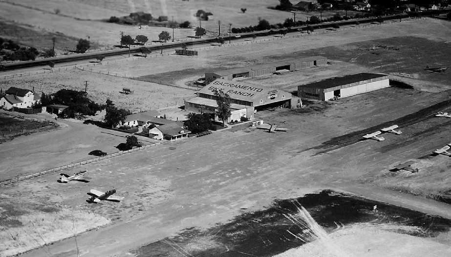
A circa 1950s aerial view looking southeast at the Sacramento Sky Ranch.
The road running parallel to the runway is Stockton Boulevard;
the intersecting street at the top of the photo is Florin Road.
Photo is used by permission of John Schwaner, via Dann Shively.
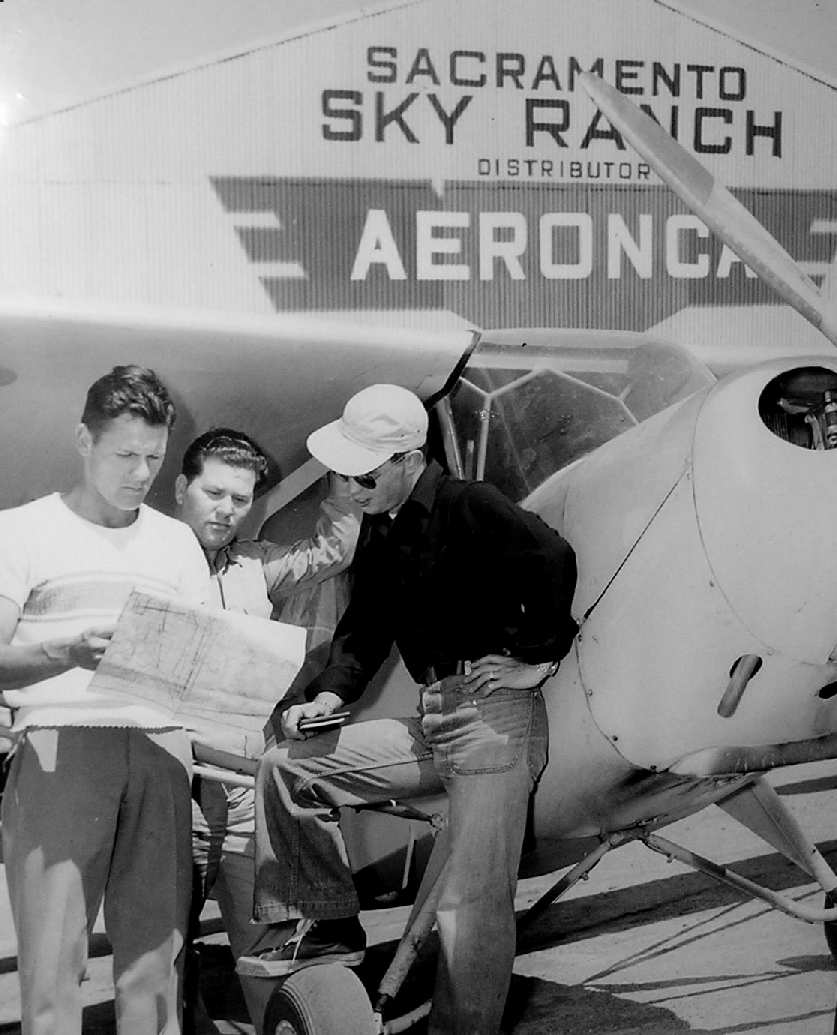
An undated photo of three unidentified men in from of a Aeronca Champ, in front of the Sacramento Sky Ranch hangar.
Photo is used by permission of John Schwaner, via Dann Shively.
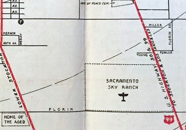
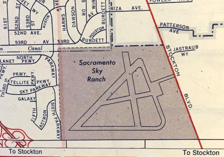
Sacramento Sky Ranch, as depicted on a circa mid-1950s street map (courtesy of Dann Shively).
The 1957 Sacramento Sectional Chart (courtesy of Chris Kennedy)
depicted Sacramento Sky Ranch as having a 2,300' unpaved runway.
A 1957 aerial photo depicted Sacramento Sky Ranch as having 2 unpaved runways & multiple taxiways,
with several buildings & 2 single-engine aircraft on the east side.
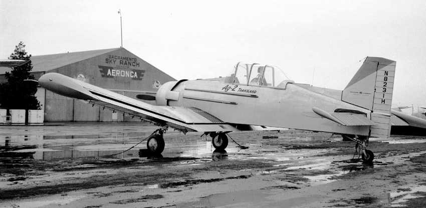
The last photo which has been located of the Sacramento Sky Ranch was a 1959 photo by Bill Larkins of a Transland Ag2 in front of the hangar.
A 1961 Gousha street map (courtesy of Kevin Walsh) depicted Sacramento Sky Ranch as having 2 runways & multiple taxiways.
The last aeronautical chart depiction which has been located of the Sacramento Sky Ranch
was on the 1961 Sacramento Sectional Chart (courtesy of Dann Shively).
It depicted Sacramento Sky Ranch as having a 2,300' unpaved runway.
Sacramento Sky Ranch was closed at some point between 1961-62,
as it was no longer depicted on the September 1962 Sacramento Sectional Chart (according to Chris Kennedy).
Owner John Schwaner sold the property, and a shopping center was built on the site.
Schwaner's business was moved to Sacramento Executive Airport.
A 1964 aerial photo showed that the runways remained intact,
but all of the airport's buildings on the east side had been removed.
A 1993 aerial photo showed the site of Sacramento Sky Ranch had been covered by the Florin Mall Shopping Center.
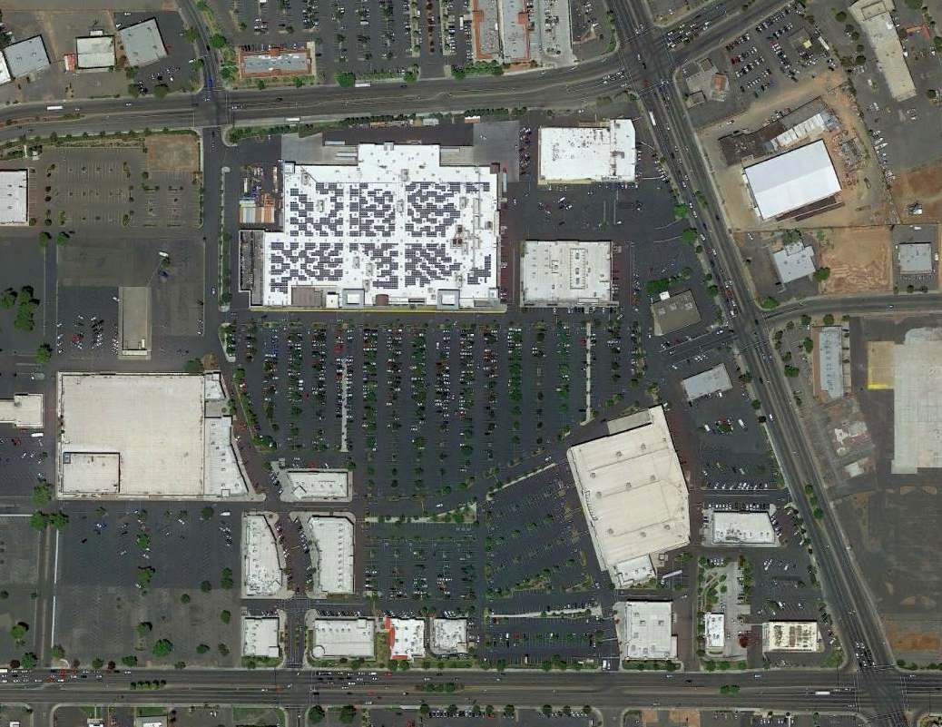
A 2015 aerial view showed no trace remained of Sacramento Sky Ranch.
The site of Sacramento Sky Ranch is located on the northwest corner of Stockton Boulevard & Florin Road.
____________________________________________________
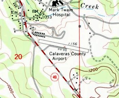
(Original) Calaveras County Airport, San Andreas, CA
38.19, -120.67 (Southeast of Sacramento, CA)
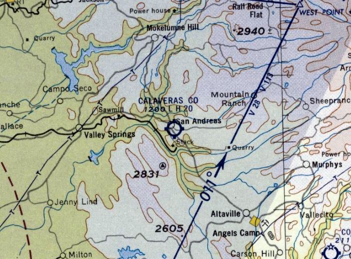
Calaveras County Airport, as depicted on the October 1956 Sacramento Sectional Chart.
The original Calaveras County Airport was located on the southern edge of the town of San Andreas.
The Calaveras County Airport may have been established at some point in 1956,
as it was not yet depicted on the 1956 USGS topo map or April 1956 Sacramento Sectional Chart.
The earliest depiction which has been located of Calaveras County Airport was on the October 1956 Sacramento Sectional Chart,
which depicted it as having a 2,000' paved runway.
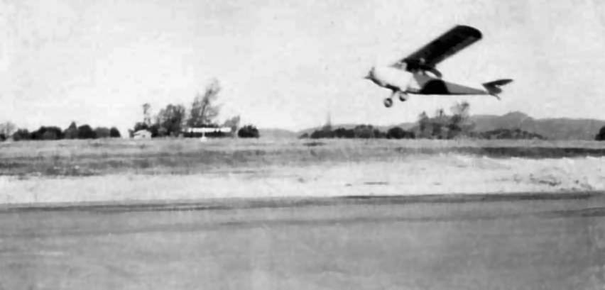
A circa 1950s photo of a plane (Aeronca?) at the Calaveras County Airport (courtesy of Randy Haight).
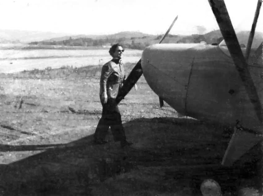
A circa 1950s photo of Nadine Haight in front of a plane at the Calaveras County Airport (courtesy of Randy Haight).
Randy Haight recalled, “My father & mother both flew out of the old Calaveras County Airport; both soloed there.
I spent many hours there as a kid.”
Calaveras County Airport was not yet depicted on the 1959 USGS topo map.
The 1962 USGS topo map depicted the Calaveras County Airport as having a northwest/southeast runway & 4 small buildings along the south side.
The earliest aeronautical chart depiction which has been located of the Calaveras County Airport
was on the September 1962 Sacramento Sectional chart (courtesy of Chris Kennedy).
It depicted the field as having a 2,100' unpaved runway.
The 1962 AOPA Airport Directory described the Calaveras County Airport as having a single 2,000' blacktop Runway 9/27.
The operator was listed as Carol Kennedy.
The 1963 USGS topo map depicted Calaveras County Airport as having a single paved northwest/southeast runway,
with 4 small buildings along the south side.
The 1967 Sacramento Sectional chart (courtesy of John Voss)
showed that the runway at the original Calaveras County Airport had been lengthened slightly to 2,150'.
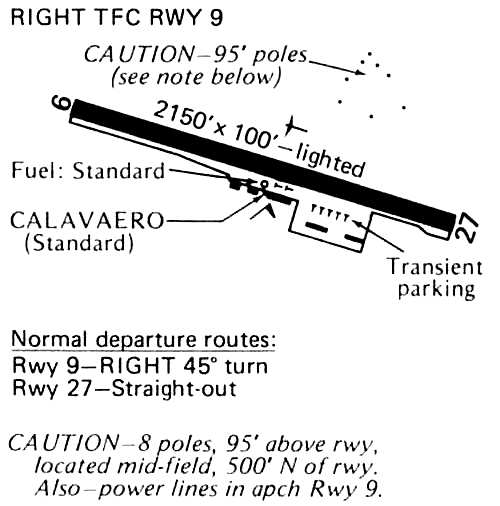
A 1978 Flight Guide (courtesy of Chris Kennedy) listed the operator at Calaveras County Airport as Calavaero.
The 1982 AOPA Airport Directory (courtesy of Ed Drury) also listed the operator as Calavaero, Inc.
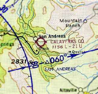
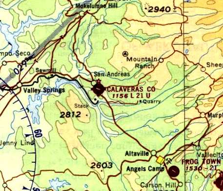
In 1982, a replacement airport, the Calaveras County Airport - Maury Rasmussen Field,
was built on a high ridge to the southeast of the town.
A 1982 aerial view looking east at the original Calaveras County Airport (copyright by John Hockenbury, used by permission).
The airport had evidently been closed in 1982,as closed-runway "X" markings were visible on the runway.
The original Calaveras County Airport was still depicted on the 1992 USGS topo map.
The original airport was no longer depicted at all (even as an abandoned airfield) on 1998 aeronautical charts.
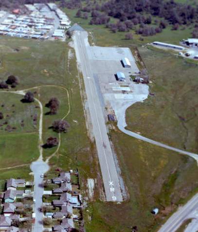
A 1998 USGS aerial view looking southwest showed the majority of the original Calaveras County Airport's runway still existed at that point,
although a housing development had been built on the northern end of the eastern end of the runway.
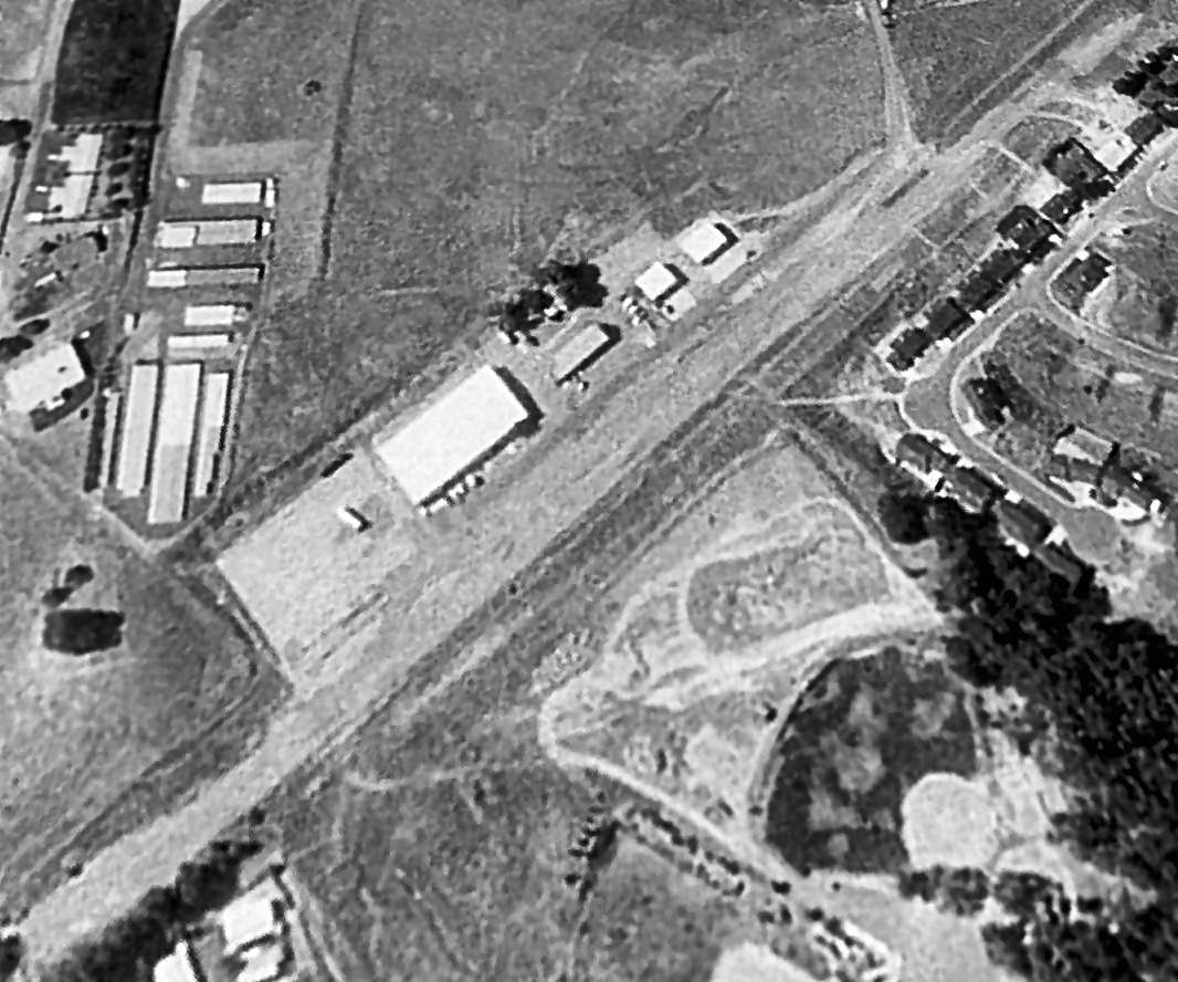
Four hangars still stood on the ramp along the south side of the runway.
Dann Shively reported in 2003 that he "had the opportunity to fly over the old San Andreas Airport.
The site hasn't changed since the [1998] aerial photo."
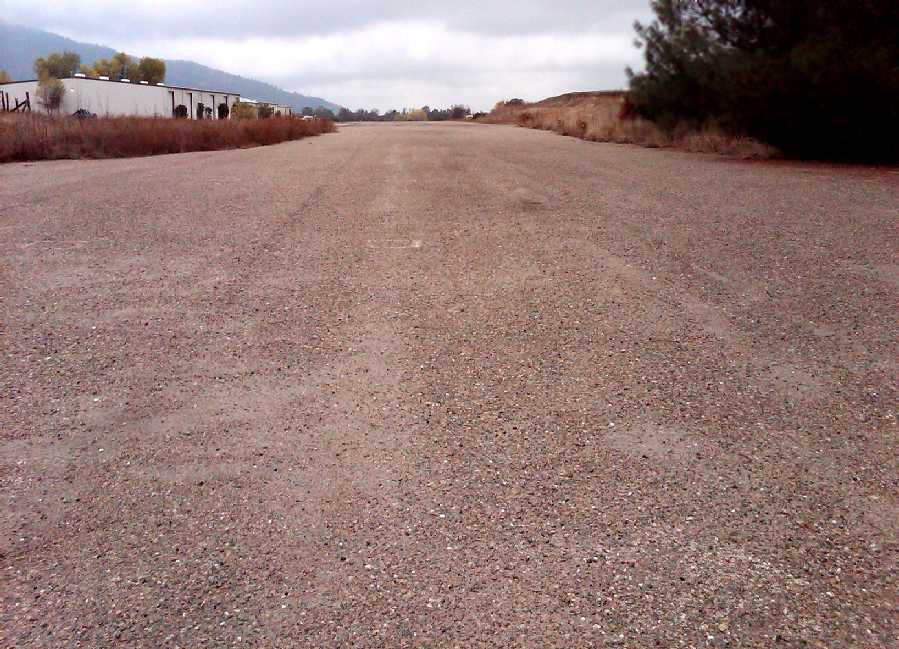
A November 2010 photo by Dann Shively looking along the former Runway 27 at the site of the original Calaveras County Airport.
Dann observed, “The runway, which seems to be hard packed gravel or rough concrete is in remarkable shape.
In my opinion you could land there right now.”
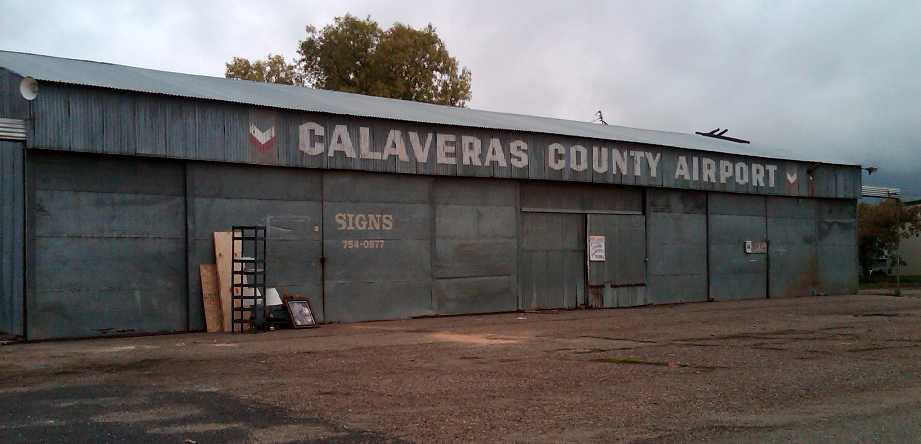
A November 2010 photo by Dann Shively of a former hangar at the site of the original Calaveras County Airport.
Dann observed, “The old office/hangar is still there but pretty ramshackle.
There are other newer buildings on the property & a couple of businesses.”
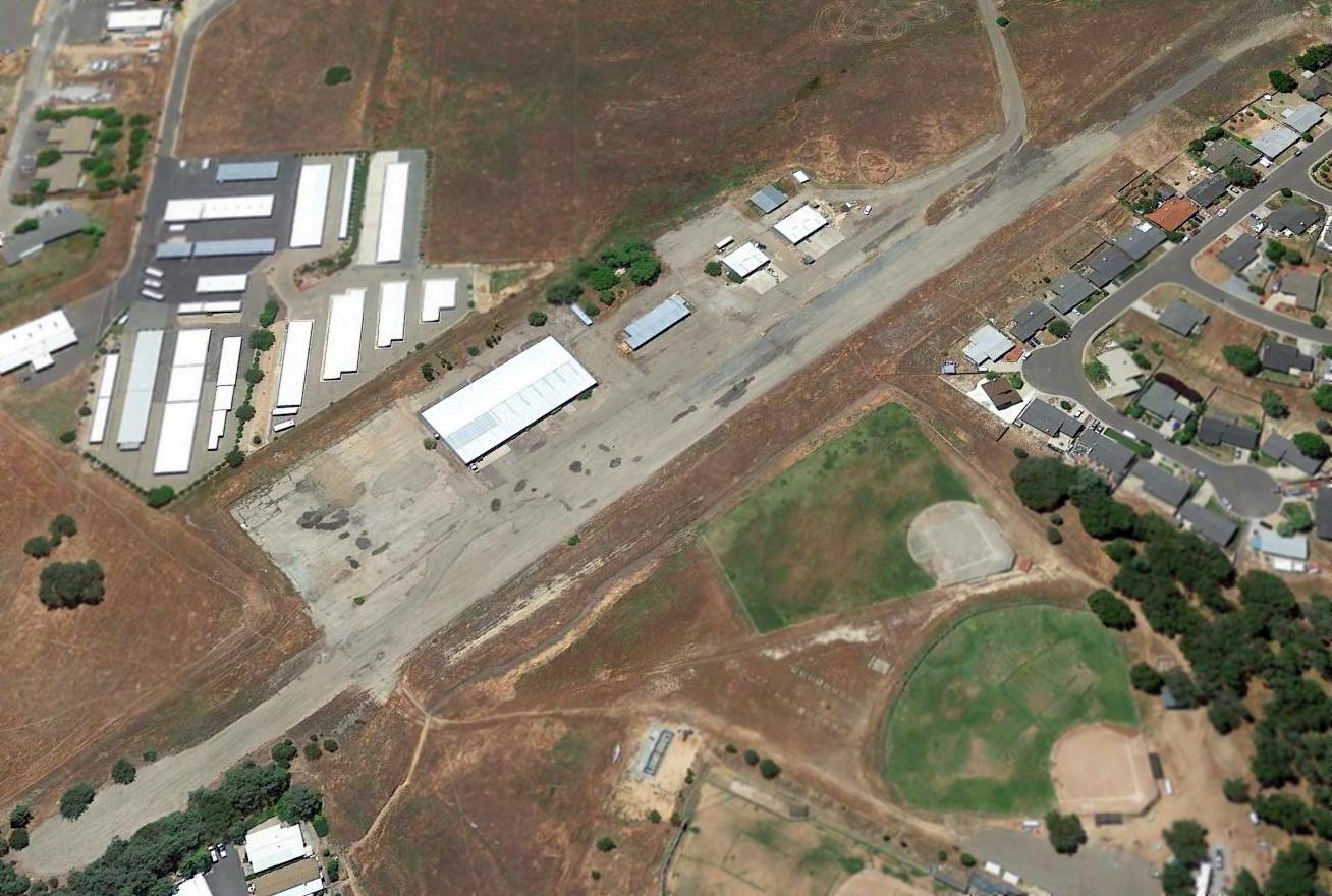
A 2014 aerial view looking southwest showed the original Calaveras County Airport to remain intact though deteriorated.
The original Calaveras County Airport is located east of the intersection of Route 49 & Airport Road,
appropriately enough.
Thanks to Denis Fabbrini for pointing out this airfield.
____________________________________________________
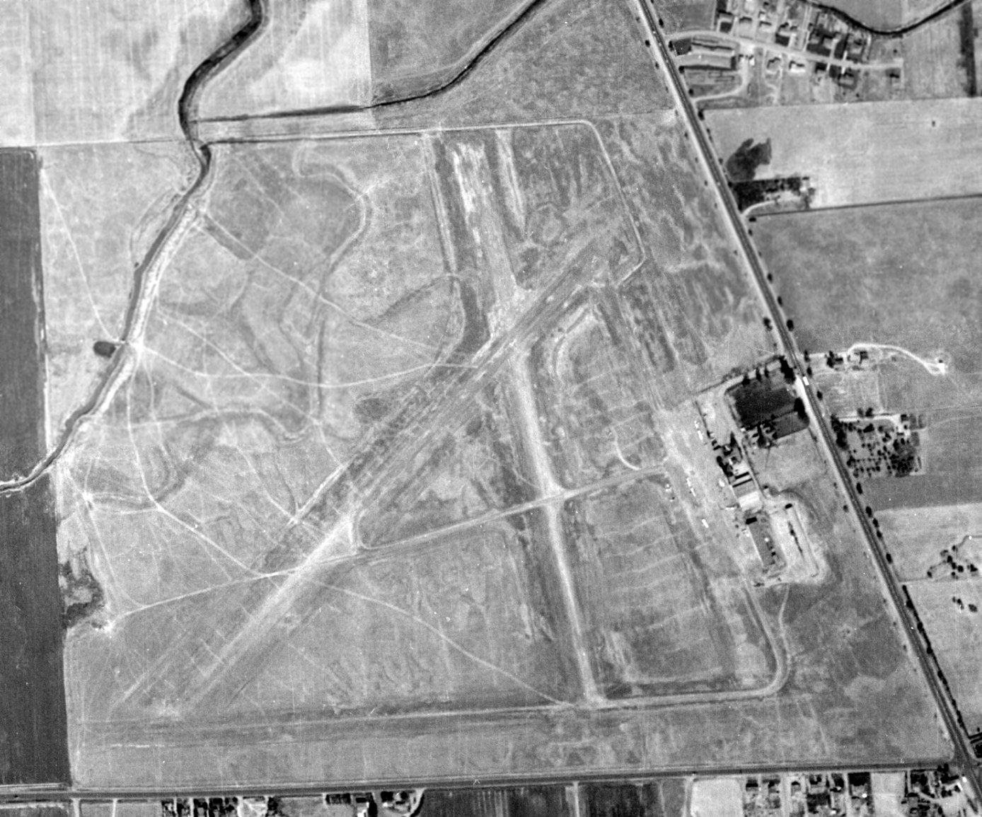
Sharpe Army Airfield, Lathrop, CA
37.84, -121.27 (East of Oakland, CA)
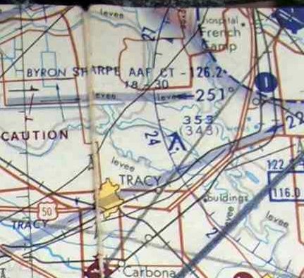
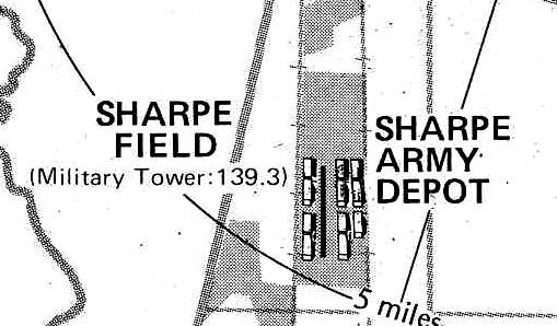
Sharpe AAF, as depicted in the 1960 Jeppesen Airway Manual (courtesy of Chris Kennedy).
This military airfield was located on the grounds of the Sharpe Army Depot.
The Depot itself existed at least as far back as 1941 (known then as Lathrop Army Depot).
The depot's airfield was not depicted on a 7/12/57 aerial photo (from the UCSB Library).
According to the book "Two Hours By Crow" by Howard & Judith Campbell (courtesy of Wings of History),
“On 6/30/59 the new airstrip was completed. It was 3,000' x 75' wide, along side the railroad.
The surface was steel pierced planking (SPP) on asphalt & became one of 4 such bases for aviation parts. The length was increased to 3,800' within months.”
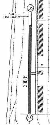
The earliest airfield directory reference to Sharpe AAF which has been located was in the 1960 Jeppesen Airway Manual (courtesy of Chris Kennedy).
It depicted the field as having a single 3,000' paved Runway 16/34, with a 500' overrun at the north end.
There did not appear to be any buildings which were directly associated with the airfield (such as any hangars).
The Aerodromes table on the 1961 San Francisco Sectional chart (courtesy of Kevin Walsh)
described Sharpe AAF as having a single 3,000' asphalt runway.
According to the book "Two Hours By Crow" by Howard & Judith Campbell (courtesy of Wings of History),
“In 1962 the base was renamed Sharpe Army Depot, and was working around the clock shipping aircraft, helicopters, and their parts.”
The earliest photo which has been located of Sharpe AAF was a 6/3/63 aerial view (from the UCSB Library),
which depicted 4 single-engine aircraft & possibly 1 helicopter parked to the east of the runway.
Sharpe AAF was not yet depicted on the 1965 USGS topo map.
The Aerodromes table on the 1966 San Francisco Sectional chart (courtesy of John Voss)
described Sharpe AAF as having a single 3,000' asphalt runway.
An Aircraft Shipment Section at the Sharpe Army Depot was used to prepare Army helicopters
for transport to Southeast Asia during the Vietnam War.
A remarkable 5/7/67 USGS aerial view (enhanced by Bill Grasha) depicted no less than 23 CH-47 Chinook helicopters,
a C-47, a single-engine fixed-wing aircraft parked to the east of the Sharpe AAF runway.
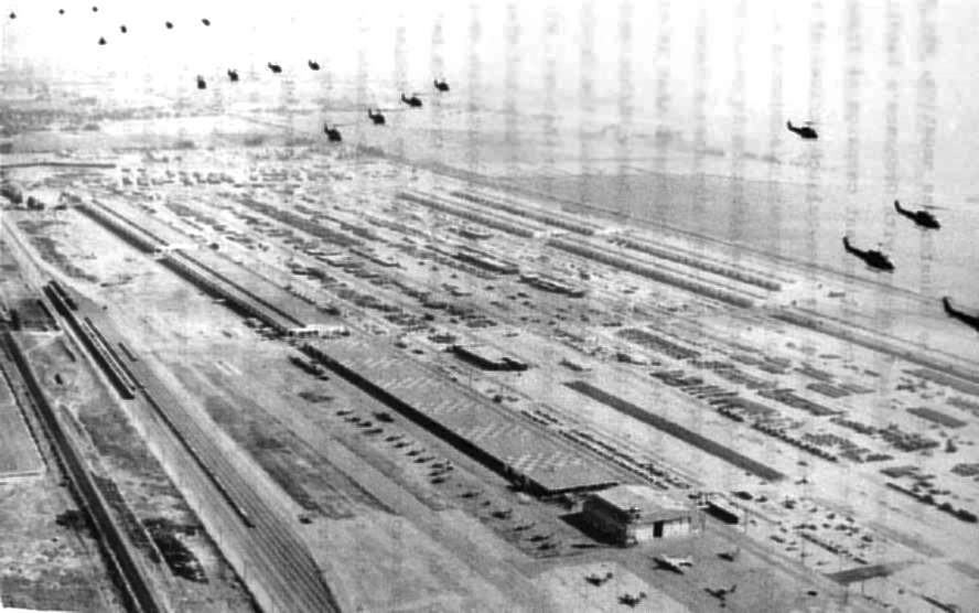
An undated (circa 1960s?) aerial view looking northeast at Sharpe AAF (courtesy of Rex Ricks, enhanced by Bill Grasha),
showing an overflight by 19 UH-1 Huey helicopters.
The hangar at bottom-right had an attached control tower.
Parked around the hangar were 5 fixed-wing aircraft (including what appears to be a C-47), as well as 16 helicopters.
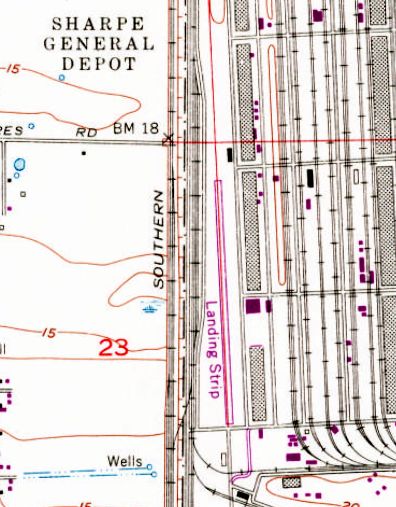
The 1968 USGS topo map depicted a single paved north/south runway, labeled simply as “Landing Strip”.
The May 1969 San Francisco Sectional chart depicted Sharpe AAF as having a paved 3,000' north/south runway.
Sharpe Field, as depicted on the 1976 Pilot's Guide to CA Airports (courtesy of Chris Kennedy).
Sharpe AAF was still depicted as an active military airfield on the 1987 CA Aeronautical Chart (courtesy of John Voss).
Sharpe AAF was labeled just "Landing Strip" on the 1989 USGS topo map.
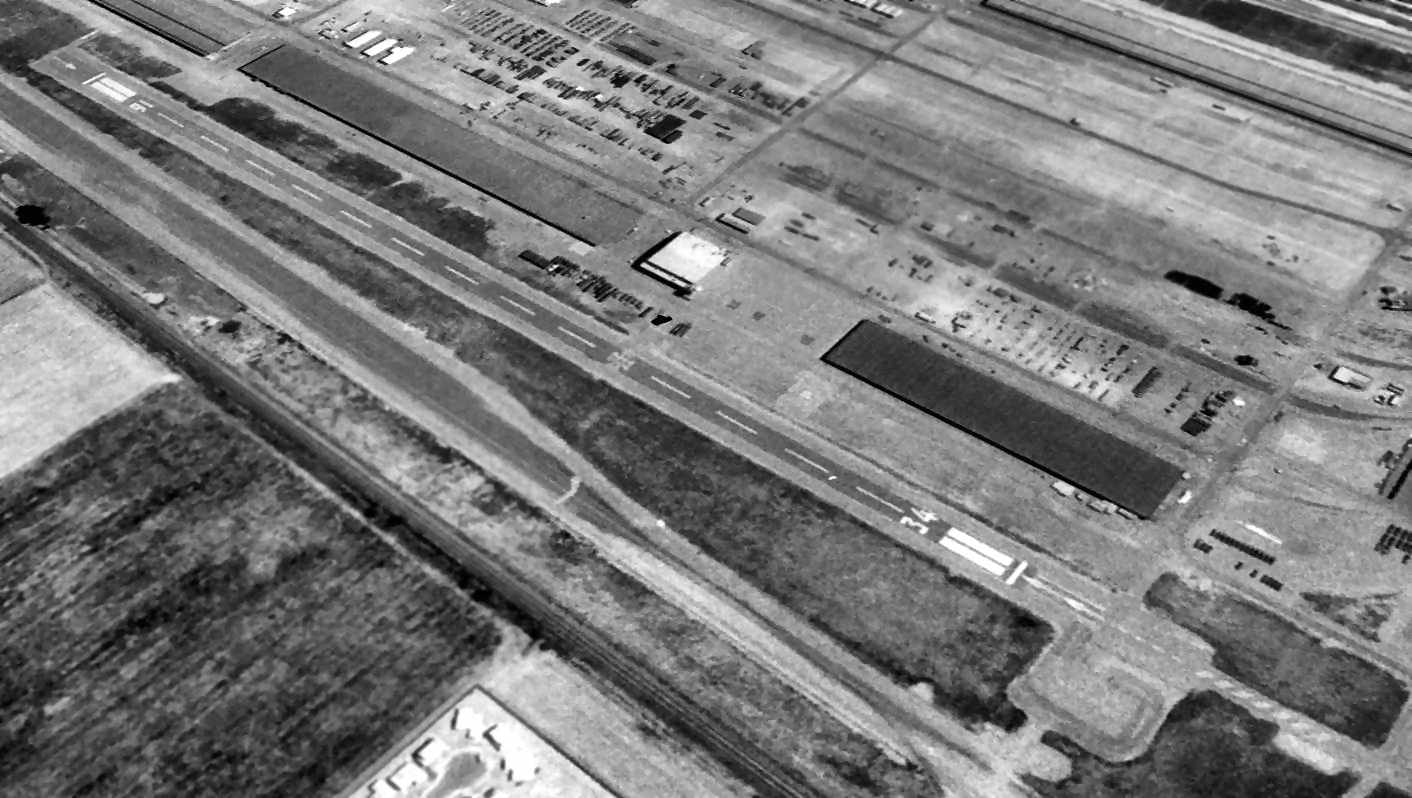
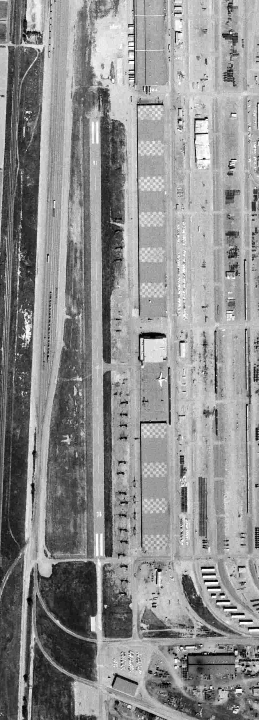
The last photo which has been located showing Sharpe AAF remaining intact was a 1993 USGS aerial view looking northeast.
It showed Sharpe AAF to consisted of a single 3,500' asphalt Runway 16/34. None of the surrounding depot buildings appeared to be used as hangars.
It was most likely that no aircraft were based at the field; it was just used by transient aircraft carrying material & personnel into & out of the depot.
According to the book "Two Hours By Crow" by Howard & Judith Campbell (courtesy of Wings of History),
“The runway was closed in 1993 & in October 1997 the facility became the Defense Distribution Depot, San Joaquin, and most of the operation began moving to Tracy.”
Sharpe AAF was no longer depicted (even as an abandoned airfield) on 1998 aeronautical charts.
The Depot was still in operation (as of 2002), known as the Defense Distribution Depot San Joaquin, CA – Lathrop.
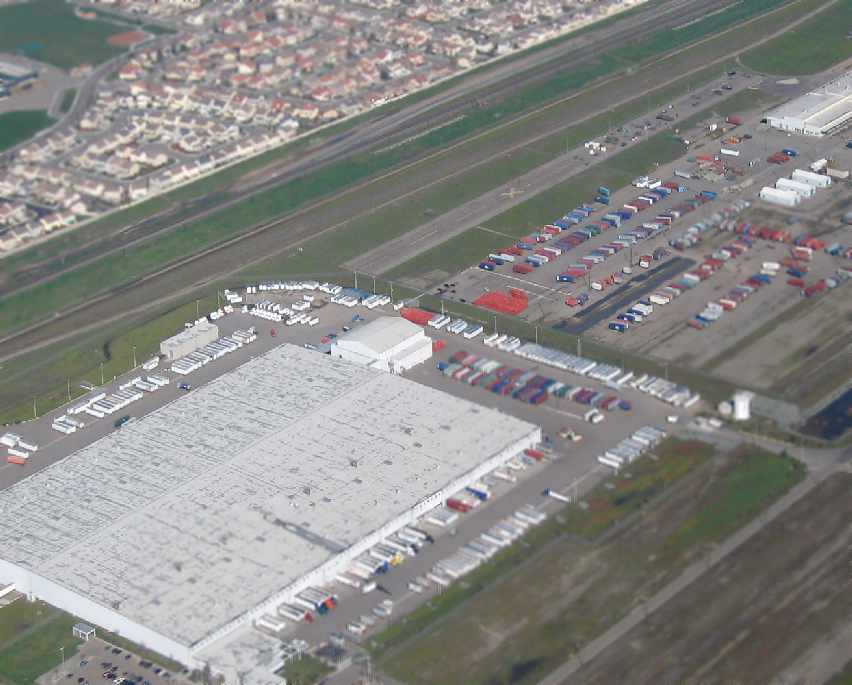
A 2007 aerial view by Ian Carisi looking northwest at the former Sharpe AAF runway.
The taller building in the center of the photo is the former hangar.
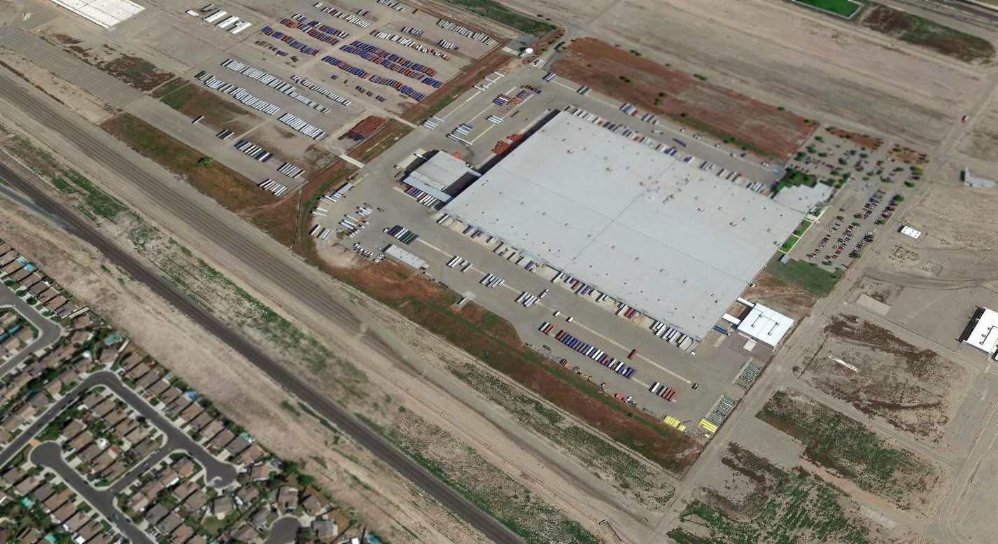
A 2015 aerial view looking northeast showed the southern half of the former Sharpe AAF runway
had been replaced by a parking lot which surrounded a large new building, which had replaced one of the long, narrow, original depot buildings.
The northern half of the former runway still existed.
The site of Sharpe AAF is located northeast of the intersection of Interstate 5 & Lathrop Road.
____________________________________________________
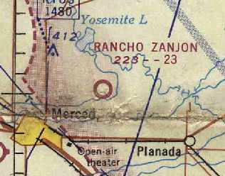
Rancho Zanjon Airfield / Madera #2, Merced, CA
37.34, -120.4 (East of San Jose, CA)
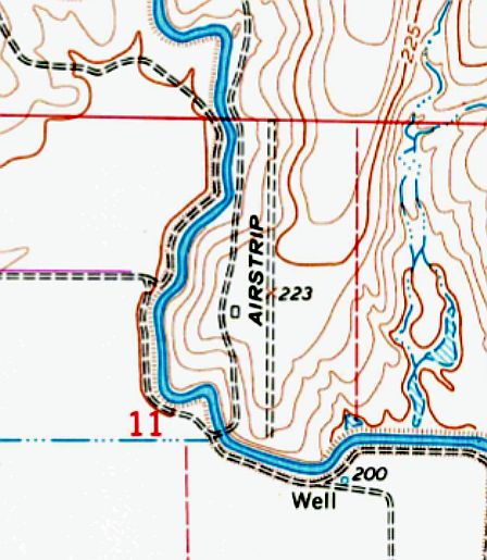
The 1961 USGS topo map depicted Rancho Zanjon as having a single north/south unpaved runway.
Photo of the airfield while open has not been located.
The Rancho Zanjon airfield was not yet depicted on 1943/47/50/56/60 San Francisco Sectional Charts nor the 1948 USGS topo map.
The earliest depiction which has been located of the Rancho Zanjon airfield was on the 1961 USGS topo map,
which depicted a single unpaved north/south runway, labeled simply as “Airstrip”.
The earliest aeronautical chart depiction which has been located of the "Rancho Zanjon" airfield
was on the June 1964 San Francisco Sectional chart (courtesy of Chris Kennedy).
It was described as having a 2,300' unpaved runway.
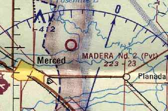
By the time of the June 1966 San Francisco Sectional Chart (courtesy of Chris Kennedy),
it was depicted as "Madera #2", and the status of the field had changed to private.
Madera #2 was still depicted as a private airfield on the 1987 CA Aeronautical Chart (courtesy of John Voss).
The 1987 USGS topo map depicted a single unpaved north/south runway, labeled simply as “Airstrip”.
However, it was apparently closed again at some point between 1987-98,
as it was no longer depicted at all (even as an abandoned airfield) on 1998 aeronautical charts.
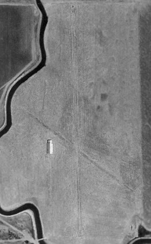
As it existed in the 1998 USGS aerial photo (enhanced by Bill Grasha), the Madera #2 airfield consisted of a 2,700' north/south runway, and a 1,600' northwest/southeast runway.
A single building or hangar sat to the west of the runway intersection, which may be unrelated to the airfield.
A circa 2006 aerial view (enhanced by Bill Grasha) looking north at the 2 runways of Madera #2, which appear to be maintained.
The building appears to be a barn, not related to the airfield.
The site of Madera #2 is located on the eastern bank of the Fairfield Canal,
northwest of the intersection of Yosemite Avenue & North Arboleda Drive, 4.5 miles northeast of Merced.
____________________________________________________
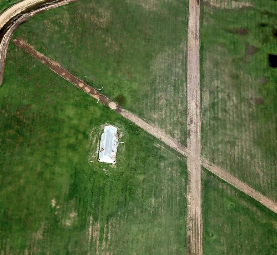
Reed Army Airfield, Sacramento, CA
38.52, -121.4 (Northeast of San Francisco, CA)

Reed AAF, as depicted on the September 1959 Sacramento Sectional Chart.
This small military airfield was located adjacent to the south side of the warehouses of the Sacramento Army Depot.
The Depot itself was established in 1941.
Several other WW2-era Army depots had similar small airfields to support Depot operations.
Reed AAF was evidently built at some point in 1959,
as it was not yet depicted on a 1957 aerial photo nor on the March 1959 Sacramento Sectional Chart.
The earliest depiction of Reed Army Airfield which has been located was on the September 1959 Sacramento Sectional Chart.
It depicted Reed AAF as having a 3,100' unpaved runway.
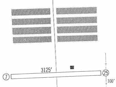
The 1960 Jeppesen Airway Manual (courtesy of Chris Kennedy) depicted Reed AAF as having a single 3,125' unpaved Runway 7/25,
with a single small building adjacent to the north side of the runway.
Reed AAF evidently gained a paved runway at some point between 1961-63,
as an August 1963 aerial photo (courtesy of Bill Calmes from Cartwright Aerial Surveys, Inc.)
showed the field having a single asphalt east/west runway.
One single-engine aircraft was visible just northwest of the runway midpoint.
A 1964 aerial photo showed Reed AAF in the same configuration as the 1963 photo.

The last aeronautical chart depiction which has been located of Reed AAF was on the January 1967 Sacramento Sectional Chart.
It depicted Reed as having a single 2,600' paved northeast/southwest runway.
Reed AAF was evidently closed (for reasons unknown) at some point between 1967-68,
as it was no longer depicted on the January 1968 Sacramento Sectional Chart.
Strangely, USGS topo maps from the 1960s & 1970s did not depict the Reed runway at all.
A 1968 aerial photo (courtesy of Bill Calmes from Cartwright Aerial Surveys, Inc.)
showed the eastern half of the Reed AAF runway had been marked with closed “X” symbols.
John Hockenbury recalled "I went to work at the now closed Sacramento Army Depot in 1970, and they had an operating airfield at that time,
flying single-engine Otters, Beavers, and helicopters in & out.
The airport was just to the south of [the Depot] warehouses & ran east/west.
I believe the strip closed in the early 1970s. It never was very active when I went there in 1970."
At some point between 1968-72, buildings were constructed over the eastern half of the runway,
as shown on a March 1972 aerial photo (courtesy of Bill Calmes from Cartwright Aerial Surveys, Inc.).
The Sacramento Army Depot was closed in 1995, and the property has subsequently been reused by several private companies.
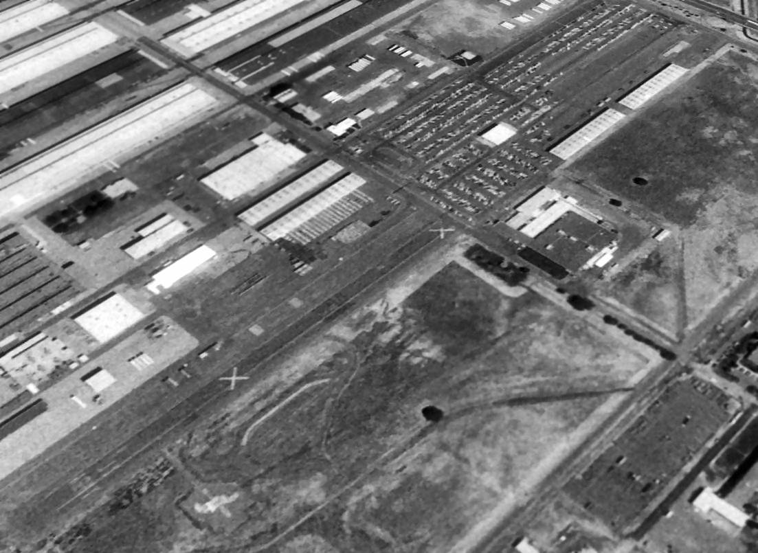
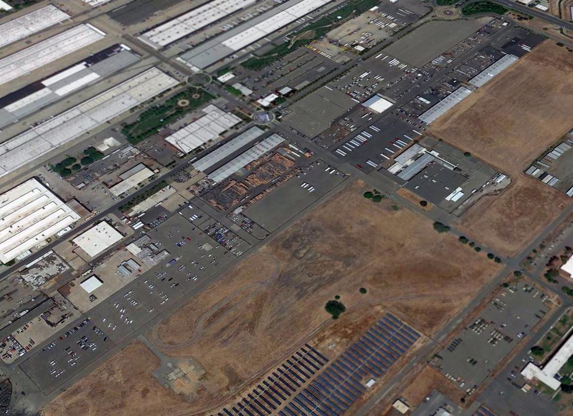
A 1998 USGS aerial view looking northeast showed a 1,600' portion of the former Reed AAF runway pavement remained intact, west of Midway Avenue.
It appeared as if the runway used to extend across the east side of Midway Avenue,
which was apparently extended after the closure of the airfield.
The remaining runway portion was still marked with two large closed-runway "X" symbols.
A 2003 aerial view by Dann Shively, looking east at the former runway of Reed AAF
(the markings "Army" are faintly visible at end of the former runway at the bottom-right).
Dan reported, “I flew over the old Army Depot yesterday (Reed AAF).
The runway is pretty much non existent now except for the far west end where the markings 'ARMY' are still barely visible.
What was the runway is now covered with buildings & storage facilities. The facility is now a private business park."
Howard & Judith Campbell reported of a visit to the Reed AAF site in their book "Two Hours By Crow" by (courtesy of Wings of History):
“This large facility is now all civilian shops & warehouses, so the security department & the administration office personnel could not help us.
They were either too young or had no interest in the facility.”
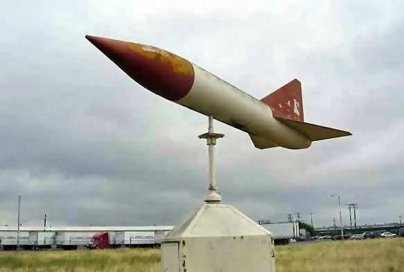
A 2005 photo by Dann Shively (enhanced by Bill Grasha) of what appears to be a former wind indicator (fashioned out of a missile of some kind), which remains at the site of Reed AAF.
Dan reported, “I flew over the old Sacramento Army Depot a while back
and noticed the last remnants of the airstrip there, the US Army lettering, is now gone from view, paved over.
I also noticed, which I missed before, is that the old tetrahedron is still there & working, just south of where the old runway was.
It's a strange-shaped wind indicator. It's almost rocket shaped.
I couldn't get a good shot from the air so ventured out to try to get it from the ground.
The property is now the Depot Business Park & is gate-guarded.
I called & explained what I wanted to the site manager & made an appointment to get onto the property.”
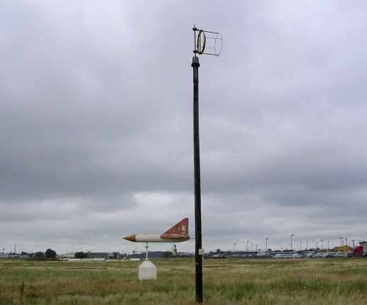
A 2005 photo by Dann Shively of the remains of the windsock frame, along with the former wind indicator, which remain at the site of Reed AAF.
Dan reported, “What I didn't see from the air is that the old windsock is also still there, although all that's left is a wooden pole & windsock frame.”
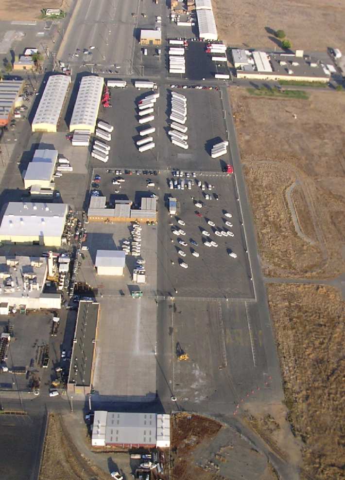
A 2015 aerial view looking northeast showed the western portion of the former Reed AAF runway remained intact, reused as a parking lot,
but no longer with any recognizable runway markings.
The site of Reed AAF is located north of the intersection of Midway Avenue & Kwajalien Street.
____________________________________________________
____________________________________________________
This site covers airfields in all 50 states.