
Abandoned & Little-Known Airfields:
California: Western San Bernardino County
© 2002, © 2026 by Paul Freeman. Revised 4/2/26.
This site covers airfields in all 50 states: Click here for the site's main menu.
For a 10th year, the CA pages of this website are sponsored by the California Pilots Association:
____________________________________________________
Please consider a financial contribution to support the continued growth & operation of this site.
(Original) Apple Valley Airport (revised 10/1/22) - Cal-Aero Airport / Fontana Gilfillan Airport (revised 7/13/24) - Crafton Hills Airport / Lincoln Airfield (revised 9/19/21)
Fontana Intermediate Field / Fontana Airport (revised 8/21/24) - K Field / Hi Desert Airport / Roy Williams Airport (revised 3/19/23)
Lake Arrowhead Airport / Squint's Ranch Airport (revised 4/2/26) - Miro-Fontana Airport / Rialto Municipal Airport (revised 3/19/23)
Morrow Field (revised 3/19/23) - San Bernardino Airport (1st location) / Shandin Hills Airport / Cooks Airport (revised 7/9/21)
San Bernardino Airport (2nd location) (revised 4/2/26) - Tri-City Airport (revised 7/9/21)
____________________________________________________
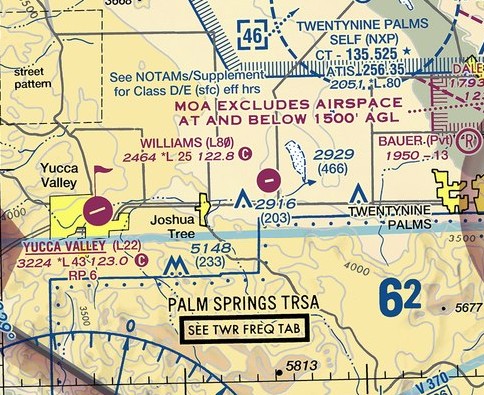
K Field / Hi Desert Airport / Roy Williams Airport (L80), Joshua Tree, CA
34.154, -116.252 (East of Los Angeles, CA)
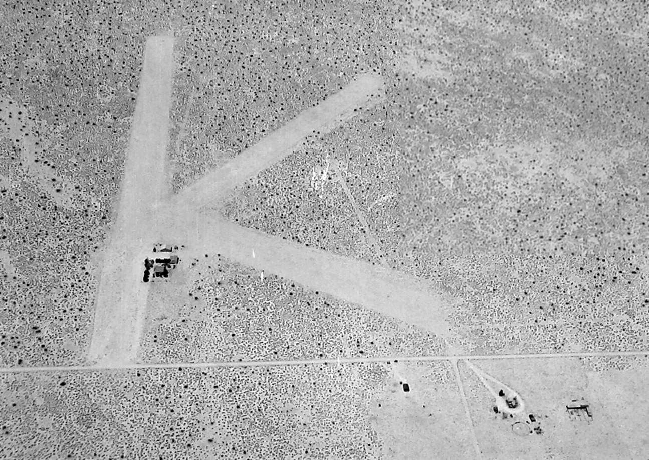
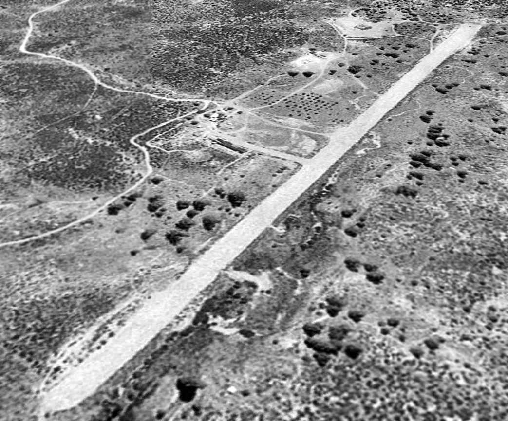
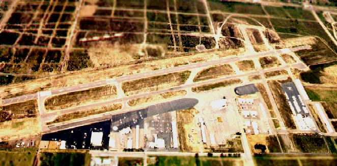
An 8/25/43 aerial view looking west at K Field (from the National Archives, courtesy of Brian Rehwinkel).
No airfield at this location was depicted on the April 1942 LA Sectional Chart.
K Field was evidently established during WW2 as one of numerous auxiliary fields which supported flight training operations from the Twenty-Nine Palms Air Academy.
The earliest depiction which has been located of K Field was an 8/25/43 aerial view (from the National Archives, courtesy of Brian Rehwinkel).
It showed the reason for the airfield's name, with an airfield configuration of 3 unpaved runways in a “K”shape.
A small set of buildings was located just south of the runway intersection.
The photo was captioned, “Dry Lake Field, Auxiliary for Condor, Twenty-Nine Palms, CA”.
No airfield at this location was depicted on LA Sectional Charts from 1944 through February 1947.
According to Bill Putnam's obituary (courtesy of his grandson Sam Wilson), at the end of WW2 Bill Putnam “decided to buy a small airport which he called K-Field in Joshua Tree, CA.
It was a struggle to keep it operating.”
The earliest aeronautical chart depiction which has been located of K Field was on the September 1947 LA Sectional Chart.
It depicted K Field as a commercial/municipal airport.
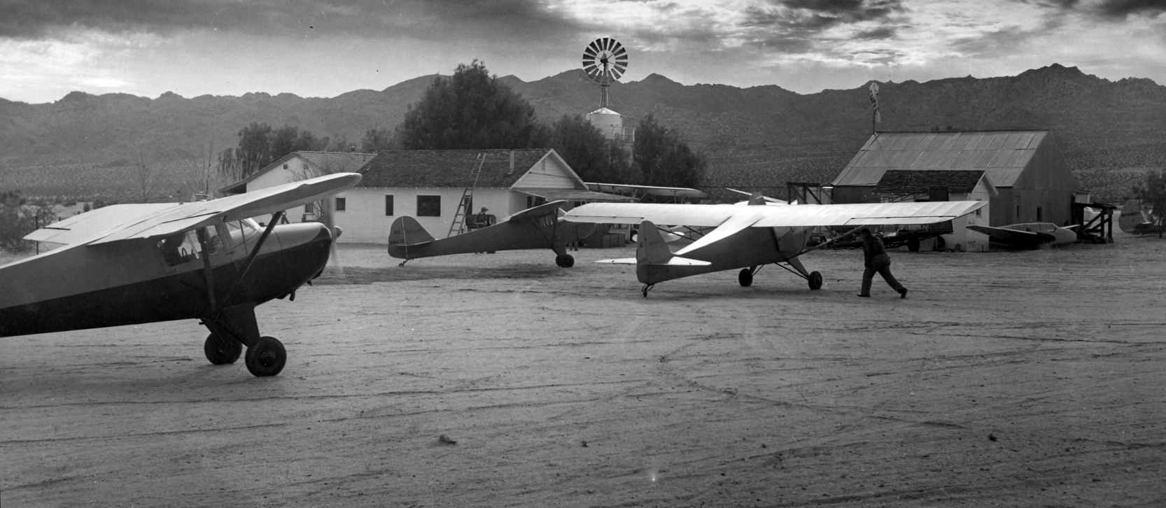
The earliest ground-level photo which has been located of K Field was on a circa late 1940s photo (courtesy of Sam Wilson),
which depicted 3 Taylorcrafts, a biplane, and a glider, in front of several hangars & other buildings.
According to Bill Putnam's obituary (courtesy of his grandson Sam Wilson), in 1949 Bill Putnam & his family moved from K-Field to Minter Field.
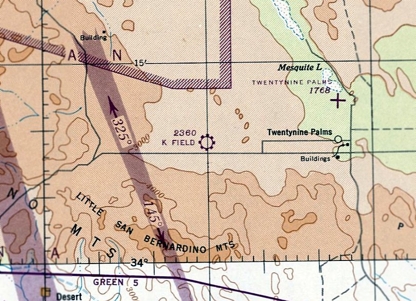
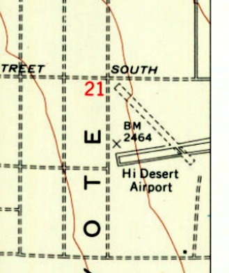
“K Field”, as depicted on the 1952 USGS topo map.
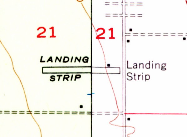
The 1955 USGS topo map depicted K Field as a single east/west runway, labeled simply as “Landing Strip”
with 1 small building on the northeast side.
K Field was not yet depicted on the March 1960 LA Sectional Chart.
The 1964 LA Sectional Chart depicted K Field as having a 2,600' unpaved runway.
According to its FAA Airport/Facility Directory data, the airport had an “Activation date” of April 1968,
but its existence obviously predated that point.
It was still depicted as K Field on the February 1969 LA Sectional Chart.
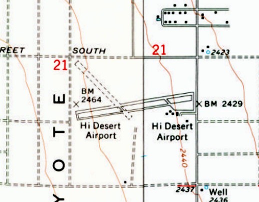
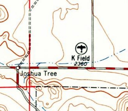
It was evidently renamed “Hi Desert Airport” at some point between 1952-72, as that is how it was labeled on the 1972 USGS topo map.
It also had gained a very different runway complement at some point between 1955-72,
with a paved northeast/southweast runway & parallel taxiway, an unpaved northwest/southeast runway,
and five small buildings on the southwest side.
The earliest aerial photo which has been located of Hi Desert Airport was a 1989 USGS aerial view looking west.
It was depicted as having an asphalt Runway 6/24 & a shorter dirt Runway 12/30.
A complex of buildings were located on the southwest side, and an asphalt ramp had a total of 12 light-single engine aircraft visible,
the largest number seen in pictures of the airport.
An 11/22/90 photo of Bill Putnam at K-Field / High Desert Airport.
According to Bill Putnam's obituary (courtesy of his grandson Sam Wilson), “He loved to pack up the family & take trips back to K-Field.”
The 1994 USGS topo map continued to label it as “Hi Desert Airport”.
It was still depicted as Hi Desert Airport on the January 1998 LA Sectional Chart (courtesy of Ron Plante).
According to Wikipedia, in 2004 “The airport was named for Roy Williams, artist & entertainer for The Walt Disney Studios,
best known as 'Big Roy', the adult mouseketeer on The Mickey Mouse Club.
Williams was also a pilot & the father-in-law of airport owner Park Richardson.”
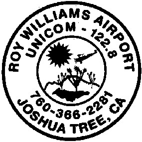
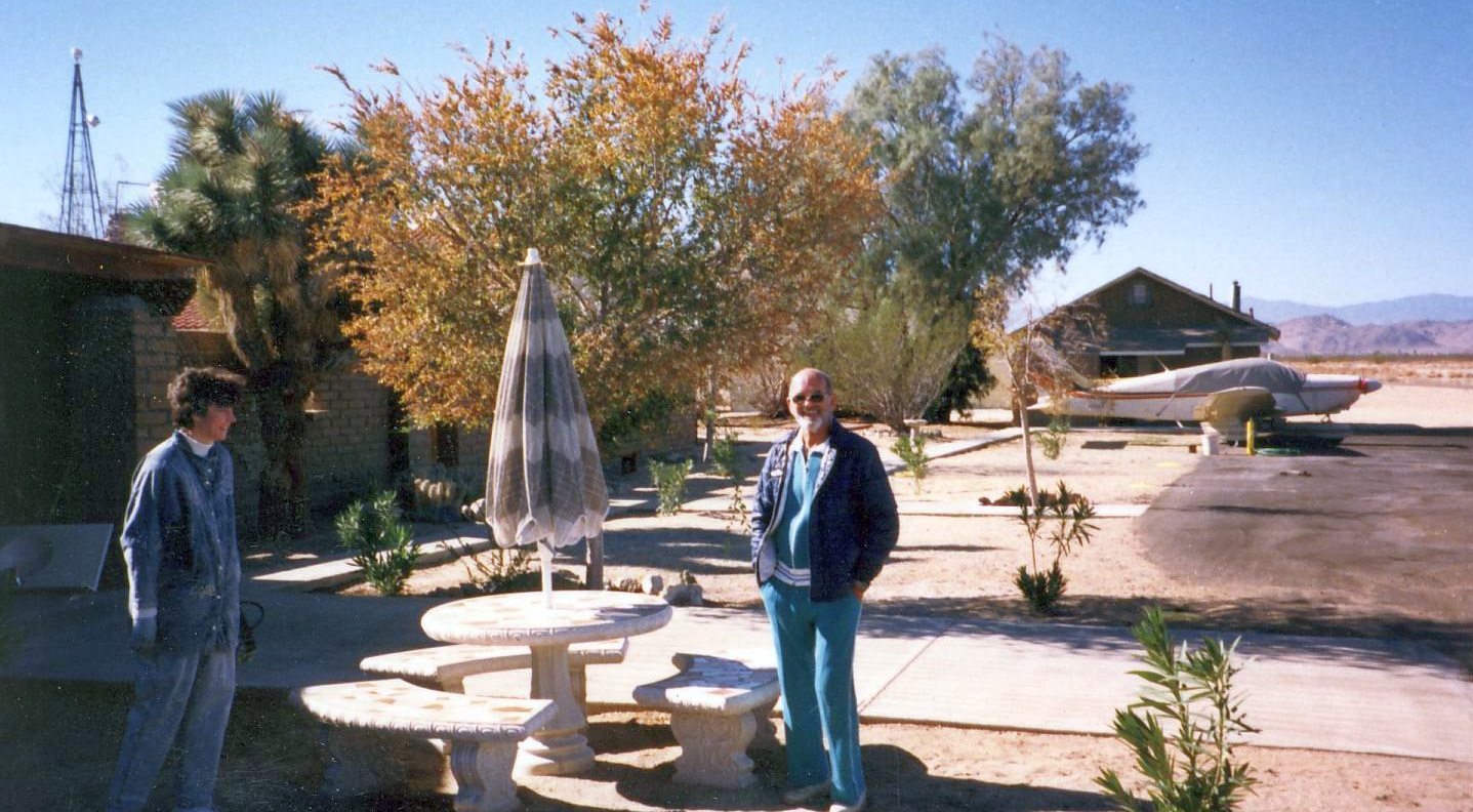
An undated logo for Roy Williams Airport.

A 2004 photo of the “Minihawk”, an extensively modified Piper PA-22 Tri-Pacer which was mounted on a pivot as an elaborate wind direction indicator at Roy Williams Airport.
The Minihawk served as a small-scale flying testbed during the early stages of Hawk Industries' GAFHawk development, first flying in 1978.
The engine was removed when the Minihawk was no longer needed, leaving the aircraft without its front section.
Apparently someone welded some plating together to give it somewhat of a nose back, before it was put on mounted at Roy Williams Airport.
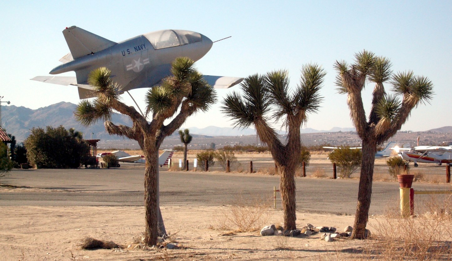
A 2007 photo by Chris Brame of beautiful Bede BD-5 on static display at Williams Airport, seemingly mounted on a joshua tree, but actually mounted on a pole behind the tree.
The BD-5 was fancifully painted with “US Navy” markings & an inverted US military insignia.
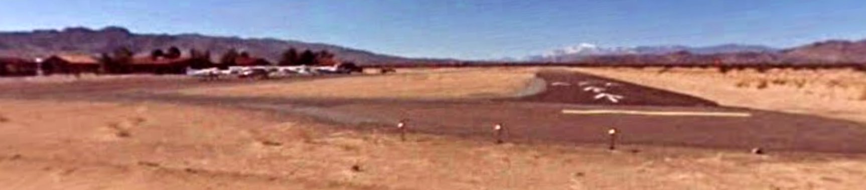
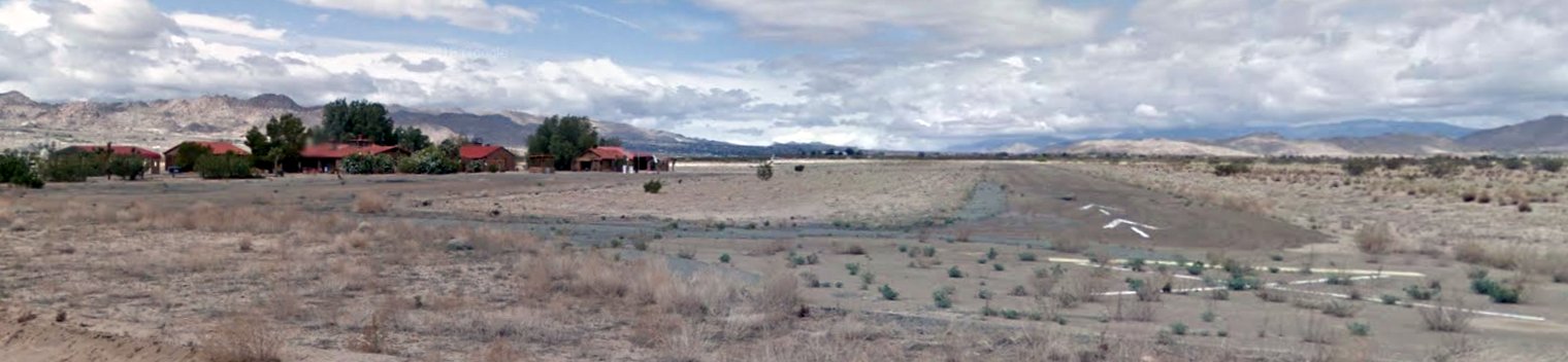
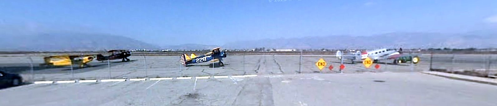
A February 2008 photo looking southwest along Roy Williams Airport Runway 24, with a number of light aircraft parked on the field.
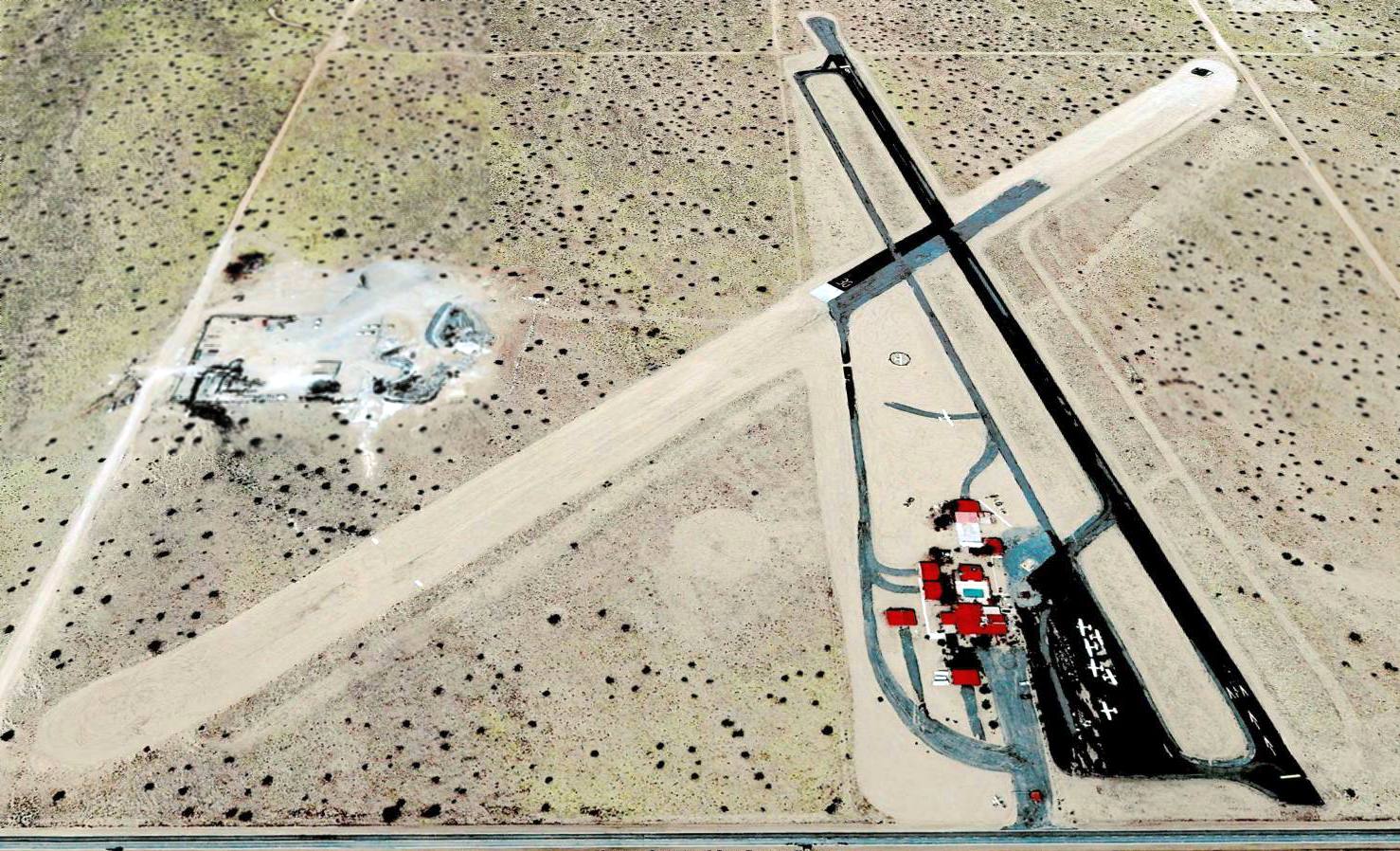
A 2009 aerial view looking west depicted Roy Williams as having a total of 7 light aircraft visible (9 if you include the static-display BD-5 & wind direction indicator Minihawk),
and a full swimming pool.
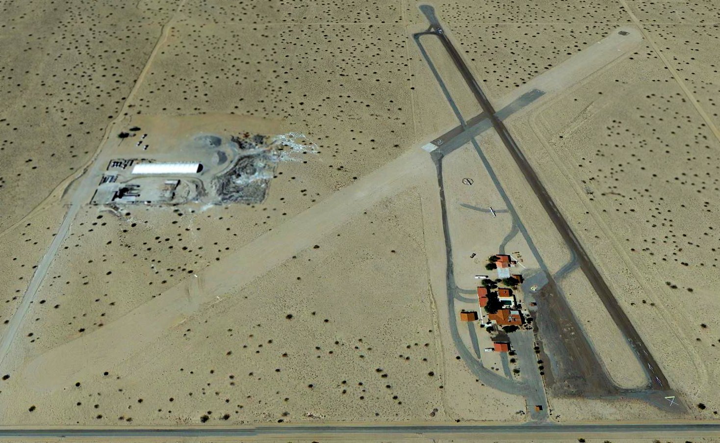
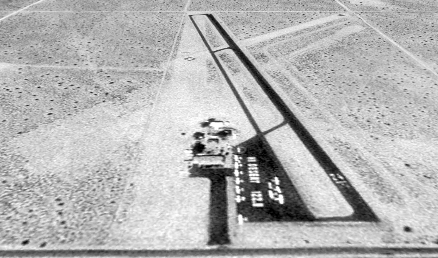
A 2013 aerial view looking west showed Roy Williams Airport's runway had been painted with a closed-runway “X” symbol.
All of the aircraft on the main ramp had vanished, with the only remaining aircraft being 1 motorglider parked west of the buildings, and the wind direction indicator Minihawk.
The static-display BD-5 had also been removed at some point between 2009-2013.
For the year 2014, the FAA Airport/Facility Directory described Roy Williams Airport as conducting an average of 17 takeoffs or landings per day,
which would be a fairly healthy amount for a small grassroots airport.
But those figures are suspect for the year 2014, given that a 2013 aerial view showed the airport being closed.
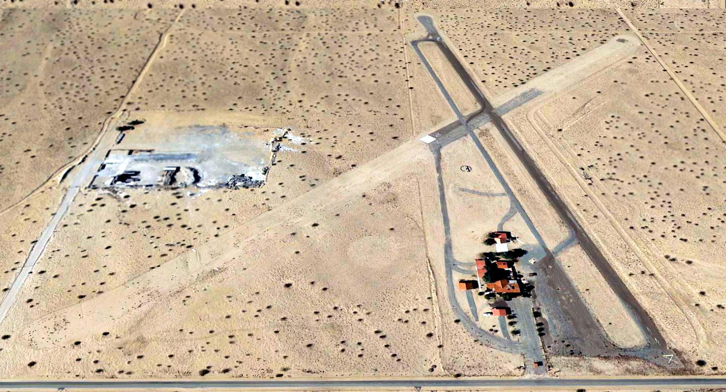
A sad 2015 aerial view looking west showed Roy Williams Airport remained intact, but the last flyable aircraft (the motorglider seen in 2013) had fled,
leaving the sole aircraft on the field as the wind direction indicator Minihawk.
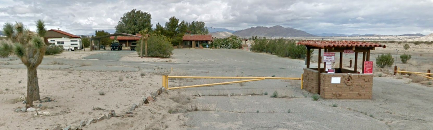
A May 2015 photo looking at the Williams Airport Runway entrance gate.
Why would a little general aviation airport have had such a gate?
A May 2015 photo looking southwest along the remains of Williams Airport Runway 24, showing the airport buildings remained intact, but the only aircraft on the field was the wind direction indicator Minihawk.
The 2017 Sectional Chart depicted Roy Williams Airport as having a single paved 2,500' northeast/southwest runway.
As of 2017, the FAA Airport/Facility Directory described Roy Williams Airport as being owned by the Richardson Family Trust, and listed the manager as Mike Hompton.
It described the airport as having a total of 14 based aircraft, including 11 single-engine aircraft & 3 ultralights.
The runway complement was described as a 2,493' asphalt Runway 6/24, “in poor condition, loose rocks & sand on runway”,
and a 2,355' asphalt/dirt Runway 12/30, “in poor condition”.
Unfortunately for us aviators, the airport status was listed as “Closed indefinitely”.
According to Wikipedia, as of 2017, “The Roy Williams Airport has been closed by the family of Park Richardson.”
Roy Williams Airport is located southwest of the intersection of Sunfair Road & 4th Street South.
Thanks to Chris Brame for pointing out this airfield.
____________________________________________________
Lake Arrowhead Airport / Squint's Ranch Airport (2CN8), Lake Arrowhead, CA
34.3, -117.15 (Northeast of Los Angeles, CA)
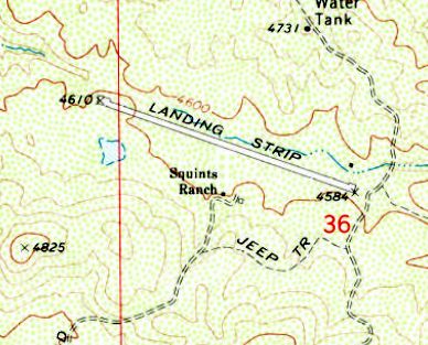
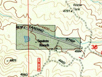
The 1971 USGS topo map depicted Lake Arrowhead Airport as a single northwest/southeast runway.
According to the 9/3/08 Mountain News, “William 'Squint' Worthington used the ranch as the base of his moonshine operation.
According to The Lost Ranch website, he provided his bootleg whiskey to the North Shore Tavern, the Saddleback Inn, the Chef's Inn and the Tudor House.
Law enforcement officers were never able to find his still.
Several of Worthington's original apple trees are still thriving on the ranch.
The ranch came to be known as 'Squint's Ranch' following its notorious use.
Squints Ranch Airfield was evidently constructed at some point between 1952-69, as it was not yet depicted on a 1952 aerial photo.
The earliest depiction which has been location of Squints Ranch Airfield was on a 1969 aerial photo.
It depicted a single northwest/southeast asphalt runway, with no buildings or other improvements.
The airstrip was originally brought to life by Allen Paulson, the founder of Gulfstream Jets.
The ranch served as a retreat for his family & had served the same purpose for the previous 2 owners.”
The earliest depiction which is available of Squints Ranch Airfield was on the 1971 USGS topo map,
which depicted a single northwest/southeast runway.
Squints Ranch Airfield was not yet depicted on the 1980 LA Terminal Aeronautical Chart.
The earliest photo which is available of Squints Ranch Airfield was a 1994 USGS aerial view looking west (enhanced by Bill Grasha).
It depicted Lake Arrowhead Airport as having a single northwest/southeast unpaved runway with a few small buildings along the south side.
The 1996 USGS topo map depicted an outline around the Lake Arrowhead Airport property.
Lake Arrowhead Airport was not yet depicted on the 1998 LA Sectional Chart.

A circa 2004 aerial view looking west (enhanced by Bill Grasha) showed Lake Arrowhead Airport in basically the same configuration as seen in 1994.
The 2009 LA Terminal Aeronautical Chart depicted Lake Arrowhead Airport as a private field having a 3,200' unpaved runway.
The Celine Dion video “Voler” was filmed at Lake Arrowhead Airport in November 2010, with beautiful aerial footage.
A 2011 photo looking west at a Cessna 207 at Lake Arrowhead Airport.
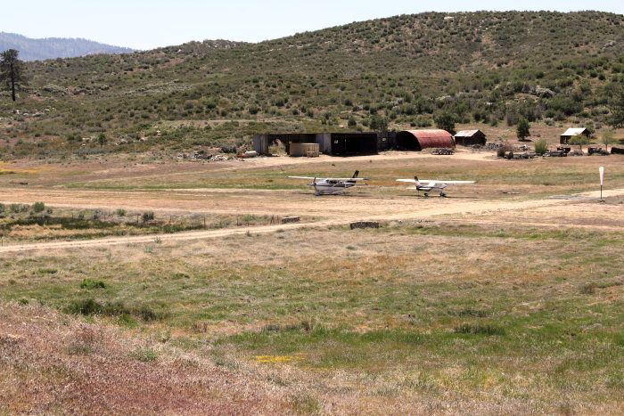
A 2011 photo of 2 Cessnas at Lake Arrowhead Airport.
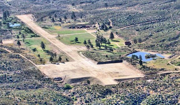
A 2012 aerial view looking east (enhanced by Bill Grasha) showed two large unpaved ramp areas which had been constructed on the west end of the Lake Arrowhead Airport runway.
Lane Leonard reported, “Lake Arrowhead Airport... I flew in there about 5 times. Gravel & dirt strip with a normal left crosswind.”
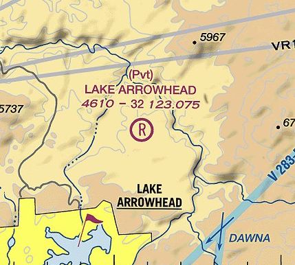
The 2014 LA Terminal Aeronautical Chart depicted Lake Arrowhead Airport as a private field having a 3,200' unpaved runway.
As of 2015, the Lake Arrowhead Airport website says the field is “Closed until further notice”.
Rob Harrison reported in 2015, “It wasn't for lack of trying that the airport failed.
I was part of a proposal to revive it. Many $$ & much time spent on it, arranging investors, master plans, etc, skilled & knowledgeable people involved.
But the lessee just wouldn't cooperate, so all our work was wasted.”
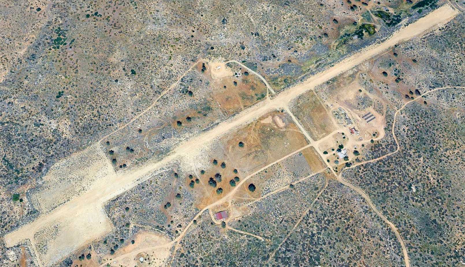
A 2025 aerial view looking northeast showed Lake Arrowhead Airport remained intact.
Lake Arrowhead Airport is located at the northern terminus of Ash Meadows Road.
____________________________________________________
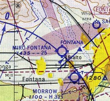
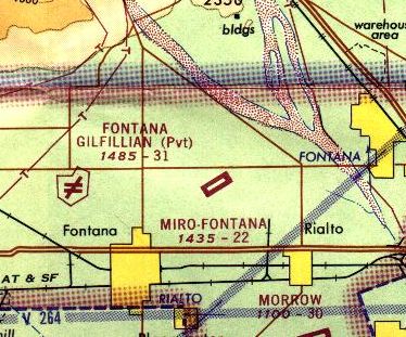
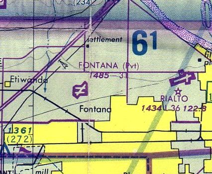
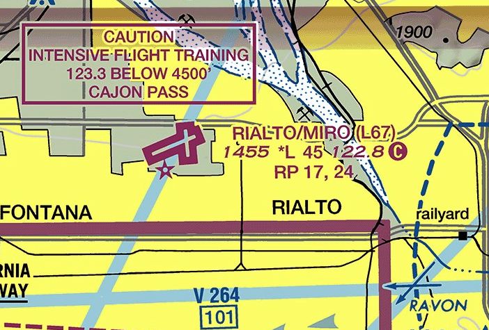
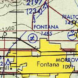
Miro-Fontana Airport / Rialto Municipal Airport (L67), Rialto, CA
34.13, -117.4 (Northeast of Los Angeles, CA)
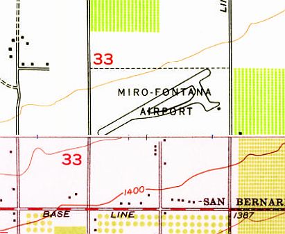
The 1954 USGS topo map depicted Miro-Fontana Airport as having a single northeast/southwest runway.
According to Wikipedia, 40 acres of land which would eventually become Rialto Airport were purchased by Sam Miro in 1944.
No airport in Rialto was yet depicted on the 1946 LA Sectional Chart.
According to its FAA Airport/Facility Directory data, Rialto Airport was activated in January 1947.
The earliest depiction which has been located of Miro-Fontana Airport was on the 1954 USGS topo map.
It depicted Miro-Fontana Airport as having a single northeast/southwest runway.
The earliest aeronautical chart depiction which has been located of Miro-Fontana Airport
was on the March 1961 LA Sectional Chart (courtesy of Chris Kennedy).
It depicted Miro-Fontana as having a 2,500' unpaved runway.
A circa 1963 ACSC map (courtesy of Kevin Walsh) depicted Miro-Fontana Airport as having a single northeast/southwest runway, with a single building on the southeast side.
The 1965 LA Local Aeronautical Chart depicted Miro-Fontana as having a 2,200' paved northeast/southwest runway.
In 1966 the City of Rialto obtained the airport property along with additional landing, bringing the total area to 60 acres.
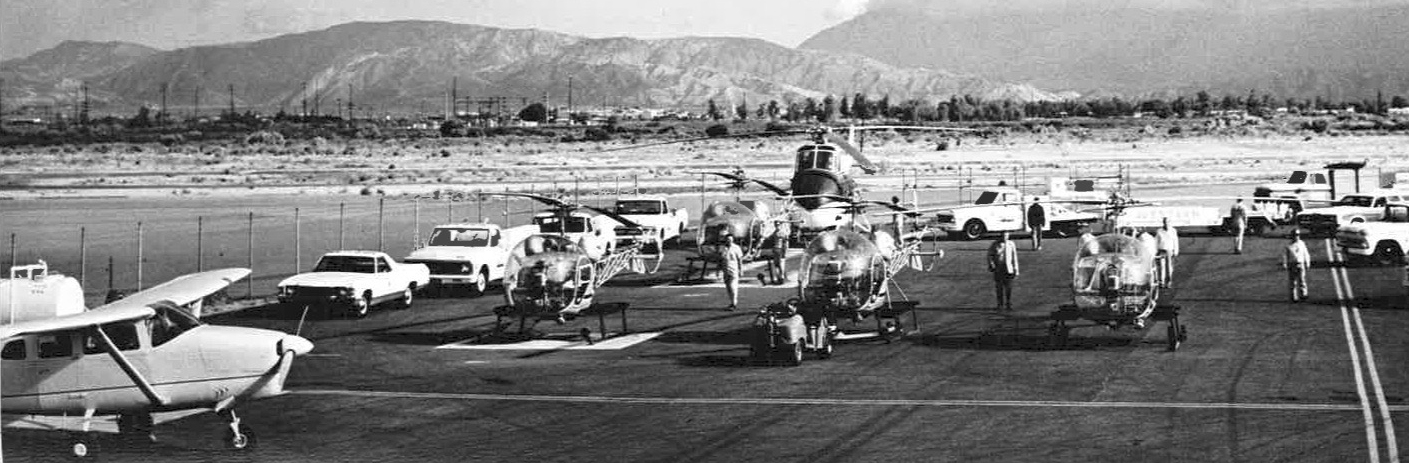
The earliest photo which has been located of Rialto Airport was a circa 1970s photo (courtesy of Douglas Williams) of 4 Bell 47s & a Sikorsky S-55 of Western Helicopters.
Douglas Williams reported, “Western Helicopters was a staple at Rialto Airport for nearly 50 years.”
In 1978 Art Scholl Aviation, founded by Art Scholl, relocated to Rialto Airport from nearby Flabob Airport in Riverside.
The August 1980 LA Terminal Aeronautical Chart (courtesy of Mitchell Hymowitz)
depicted Rialto Airport as having 2 paved runways, with the longest being 3,600'.
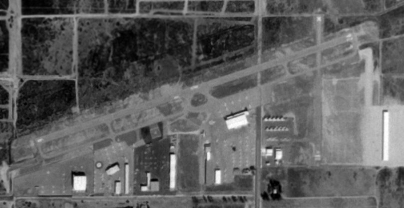
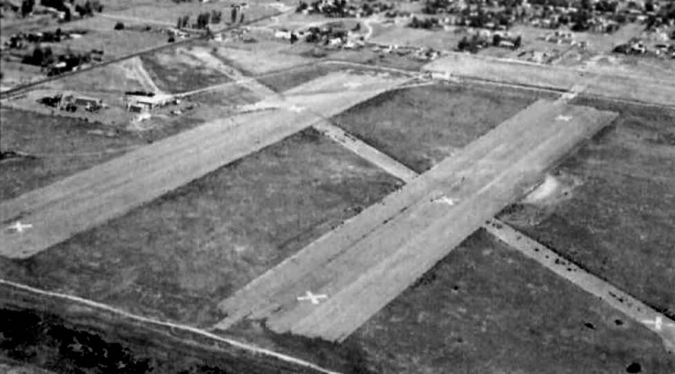
The earliest aerial photo which has been located of Rialto Airport was a 10/21/80 USGS aerial view.
It showed Rialto Airport to have 2 paved runways, with several hangars & a large number of planes on the south side.
A circa 1980s photo (courtesy of Douglas Williams) of 2 Hughes 300s, 2 Hughes 500s, and a Sikorsky S-55 of Western Helicopters at Rialto Airport.
A circa 1980s photo (courtesy of Douglas Williams) of a Bell JetRanger of Western Helicopters at Rialto Airport.
A circa 1980s photo (courtesy of Douglas Williams) of a North American B-25 Mitchell bomber & Republic P-47 Thunderbolt fighter at Rialto Airport.
A circa 1980s aerial view (courtesy of Douglas Williams) looking west at Rialto Airport during a car show.
An undated aerial view of a gathering of warbirds in front of the Art Scholl Aviation facility at Rialto.
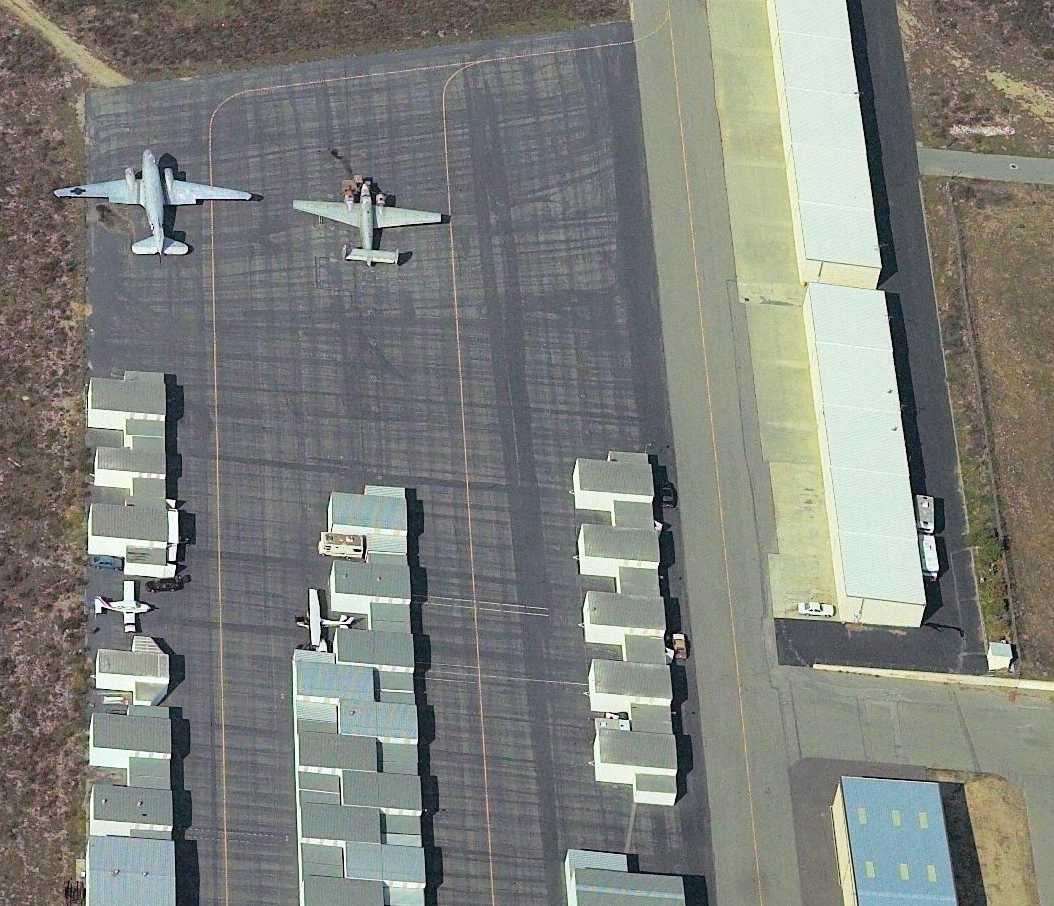
A 1997 aerial view looking north at Rialto Airport showed a large population of aircraft on the south side.
A 2002 aerial view looking west still showed Rialto Airport as having a healthy number of aircraft, including a DC-3.
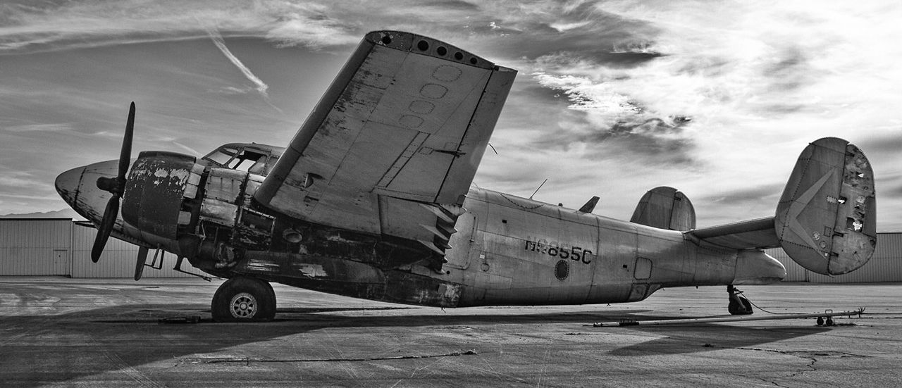
A 2004 photo by Ernie Viskupic, which Ernie reported was “of the Lockheed PV-2 Harpoon that was abandoned at Rialto Municipal Airport.
I spent many Saturdays at Westpac Restorations. I was a volunteer crew member on their B-25 'In the Mood'.
This was their base of operations until they moved to Colorado Springs in 2008.”
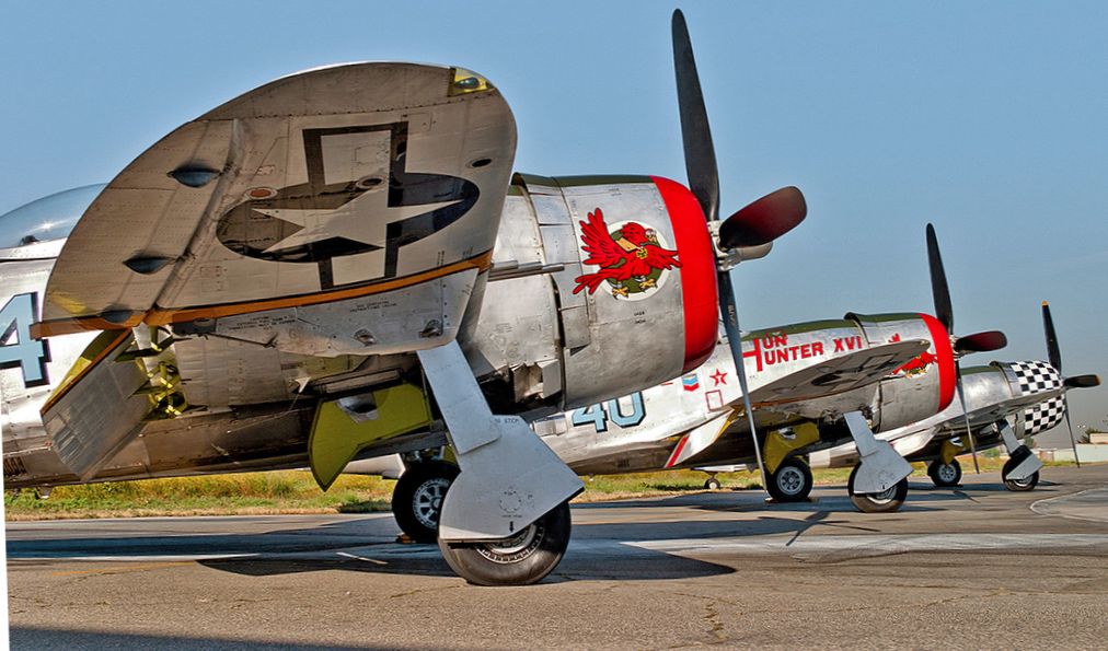
A 2005 photo by Ernie Viskupic of 3 beautiful P-47D Thunderbolts at Rialto Airport.
A November 2007 photo looking north at several Stearman & other vintage planes at Rialto Airport.
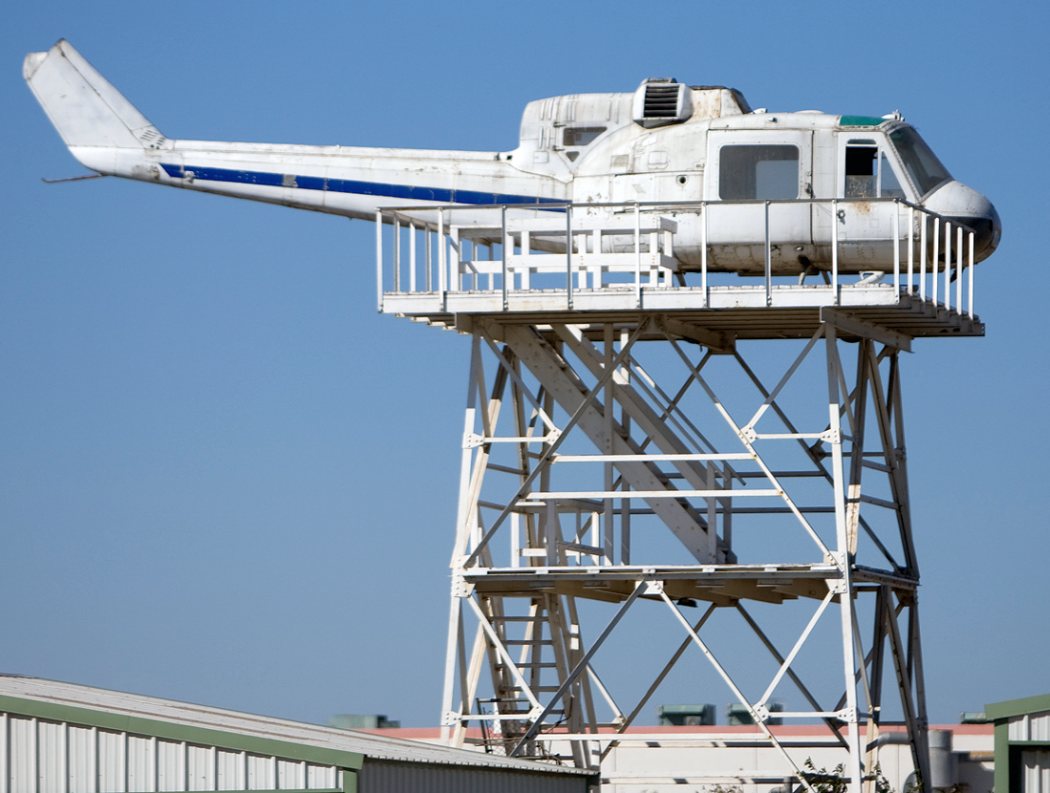
A 2009 photo of tower-mounted UH-1D Huey at Rialto Airport
used for training by the San Bernardino County Sheriff's Department Aviation Division.
A 2010 aerial view looking north at a DC-3 & Lockheed PV-2 on the east side of Rialto Airport.
From 1984-2014 the City of Rialto accepted more than $15 million in federal aid for airport improvement & land purchases.
In 2014, its last year of operation, Rialto Airport's FAA Airport/Facility Directory data
described the field as having 2 asphalt runways: 4,500' Runway 6/24 & 2,650' Runway 17/35.
The owner was listed as the City of Rialto, and the manager as Richard Scanlan.
Strangely, the field was said to have only a sole based aircraft (an ultralight),
yet to conduct an average of 82 takeoffs or landings each day.
Businesses on the field were listed as Art Scholl Aviation, Western Helicopters, and Rialto Air & Sport Cafe.
As of 2014, Warbirds West Air Museum operated its warbird collection from the big hangar at the center of the field.
The airport cafe was attached to the WWAM hangar.
An air ambulance business was located in the southeast part of the airport.
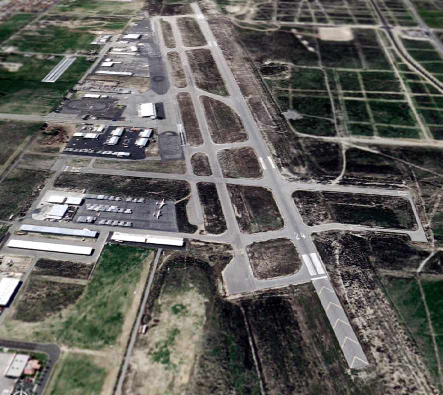
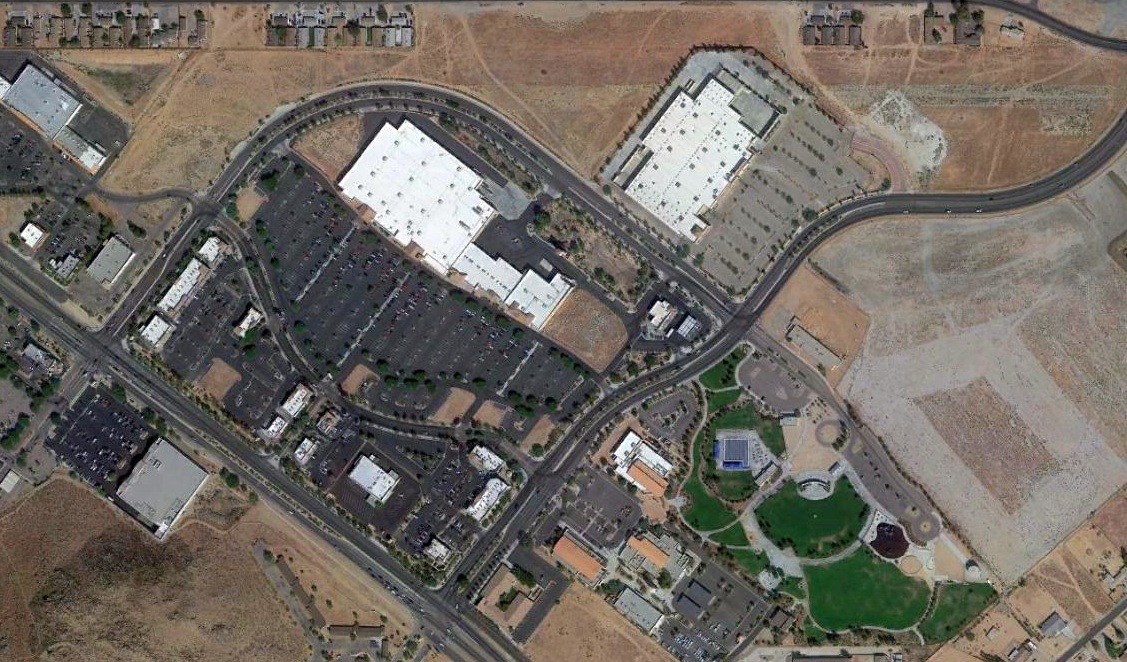
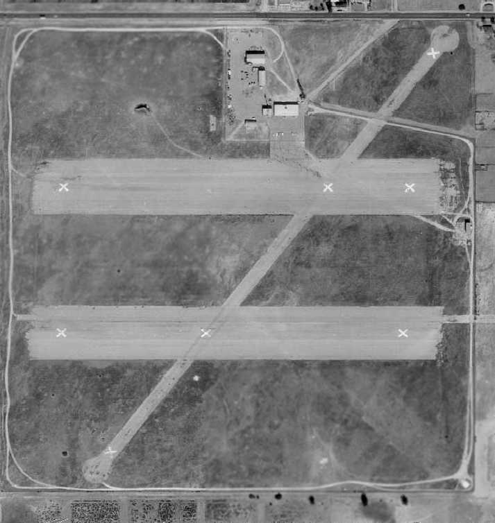
A 4/27/14 aerial view looking northwest at Rialto Airport showed a sad contrast to previous pictures, with a dearth of aircraft on the field.
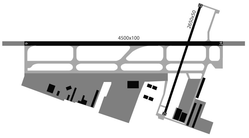
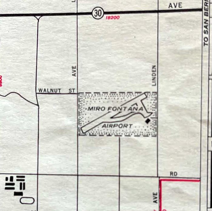
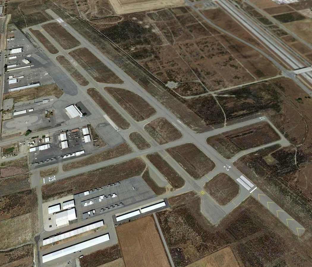
A 2014 airport diagram of Rialto Airport.
The 2014 LA Terminal Aeronautical Chart depicted Rialto/Miro as having 2 paved runways.
Pressure from real estate developers led the City of Rialto to move for the closure of the airport,
once the San Bernardino County Sheriff's Department Aviation Division relocated to the San Bernardino International Airport.
On 9/18/14, Rialto Airport officially closed to air traffic, and the runways were marked with yellow closed-runway X symbols.
Development of a Target Corporation store was planned to begin as soon as the runways were removed.
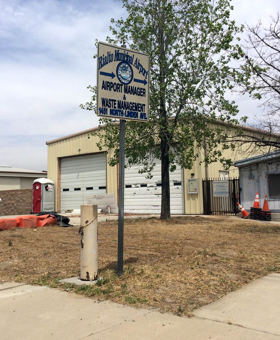
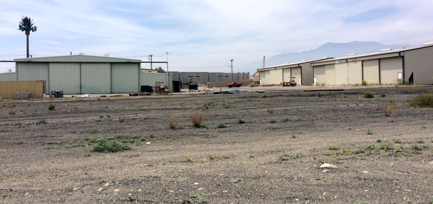
A 5/15/17 photo by Matt Franklin of the sign for the Rialto Municipal Airport manager's office.
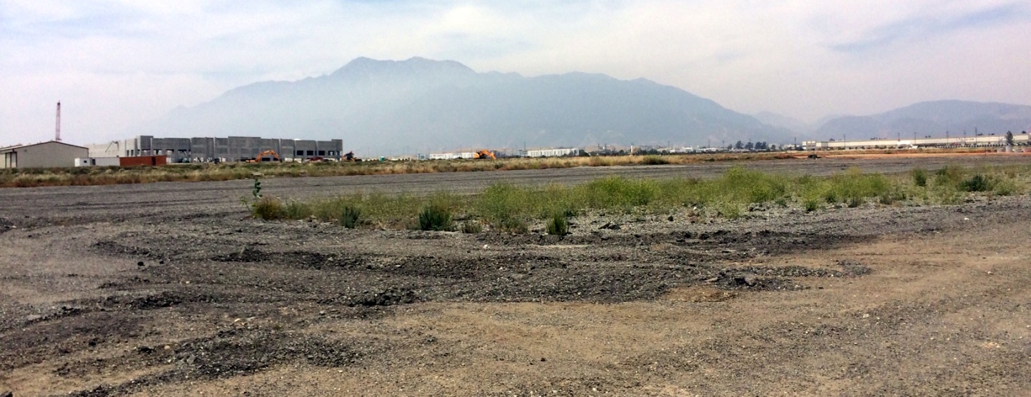
A 5/15/17 photo by Matt Franklin of remains of runway pavement at the site of Rialto Municipal Airport.
Matt reported, “It’s pretty much chewed up with earth movers, and there were big piles of ripped up concrete.
The majority of the western end of the runway has been converted into distribution centers, and the east end of the airport has been leveled.”
A 5/15/17 photo by Matt Franklin of a former T-hangar which remains standing at the site of Rialto Municipal Airport.
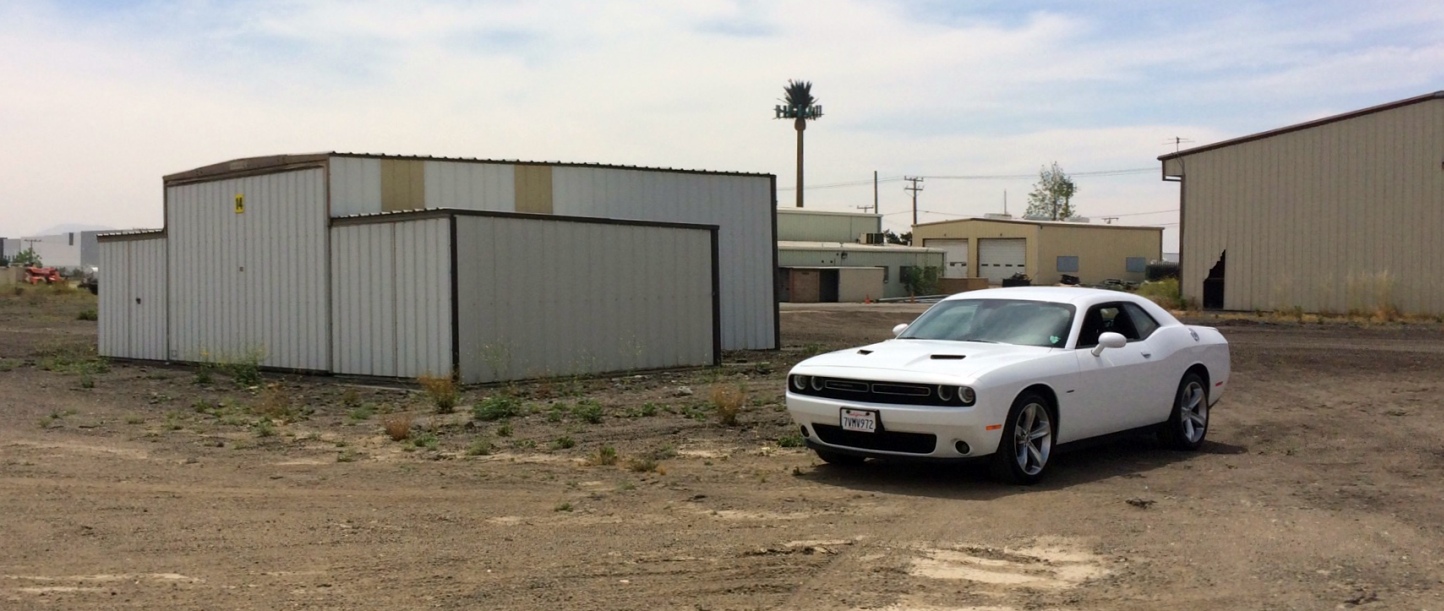
Matt reported, “I took my rental Challenger for a tour of the mulched asphalt.”
A 5/15/17 photo by Matt Franklin of former hangars which remain standing at the site of Rialto Municipal Airport.
Matt reported, “There are still a few hangars with what I would believe are temporary tenants until the entire area becomes redeveloped.”
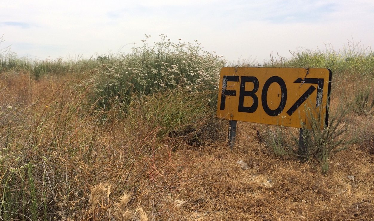
A 5/15/17 photo by Matt Franklin of a forlorn sign pointing they way to the Rialto Municipal Airport FBO.
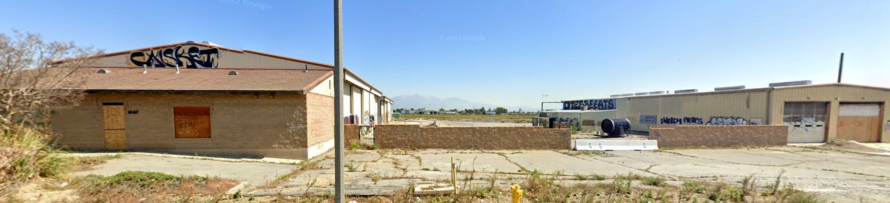
A sad March 2022 photo looking east at the few Rialto Airport hangars which remain standing, vandalized with graffiti.
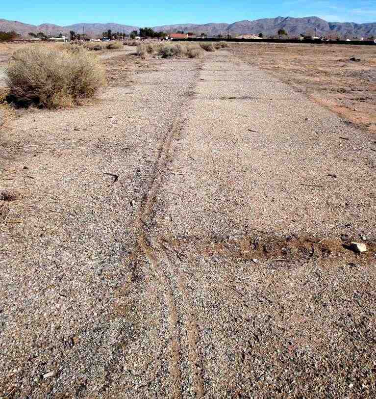
A March 2022 photo looking northeast along the remains of Rialto Airport Runway 6.
____________________________________________________
Crafton Hills Airport / Lincoln Airfield, Yucaipa, CA
34.03, -117.07 (East of Los Angeles, CA)

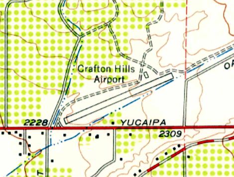
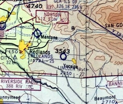
Crafton Hills Airport, as depicted on the September 1950 LA Sectional Chart.
This small general aviation airport was evident established at some point in 1950,
as it was not yet depicted on a 1938 aerial photo or the March 1950 LA Sectional Chart.
According to Sahara Diana Quinn, “Winslow Lincoln was not only a prominent citrus grower in Dunlap, he was also known as the 'Flying Farmer'.
Lincoln developed the 300-acre Golden Globe citrus ranch & took up flying enthusiastically when he was 53 [in 1946].
At the foot of Katzung Hill, the 'Lincoln International' Airport was established after he learned to fly. He became the president of the California Flying Farmers Association.
Lincoln would invite people from Redlands to a picnic and some 20 little broad-winged planes would fly in with people with sunglasses, cameras, sandals and Hawaiian shirts.
The pilots 'winged in' & bounced to a stop on the 2,300' landing strip in a plume of dust.
Members of the Sheriff’s Reserve unit would help park the planes & supervise takeoffs & landings.
Elmer Seneff from the Yucaipa Forestry Station would stand by the forestry truck.
The group would hitch a ride the half-mile to a eucalyptus grove where the barbecue grounds were.”
The earliest depiction which has been located of Crafton Hills Airport was on the September 1950 LA Sectional Chart.
It depicted Crafton Hills Airport as having a 2,300' unpaved runway.
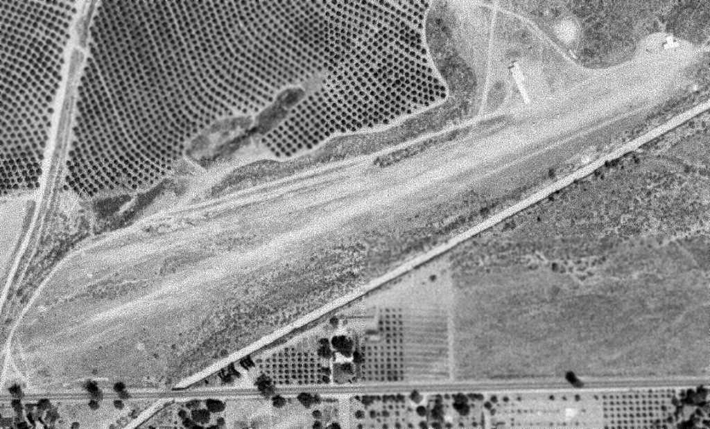
The earliest photo which has been located of Crafton Hills Airport was a 7/13/52 USGS aerial photo.
It depicted the field as having a single northeast/southwest runway, with several T-hangars on the north side.
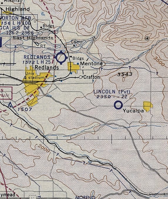
The 1954 USGS topo map depicted Crafton Hills Airport as having a single northeast/southwest runway,
with a single small building on the north side.
According to Sahara Diana Quinn, “During its heydays in the 1950s, the Flying Doctors & Flying Realtors joined in using the facility with the Flying Farmers.
Red Miller was one of the airborne realtors. Dr. Miller operated his own plane as well.
In 1957, a Quonset hut was added as the new Civil Air Patrol’s headquarters; it was 29' wide & 40' long, located west of the hangars.
Clifford Martin was the CAP commander Major with Jim Martines as Assistant Commandant.
The airport was a popular spot of airplane clubs.”
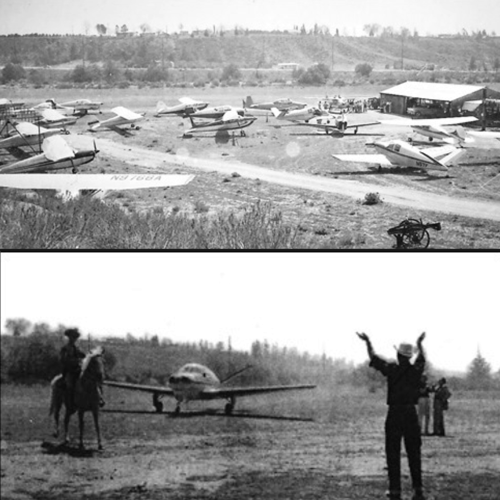
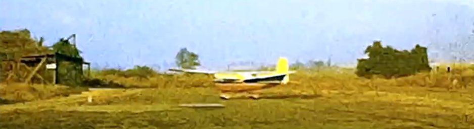
Two circa 1950s photos (courtesy of Steven Clark) showing a large number of light general aviation planes at Crafton Hills Airport.
A 1959 aerial photo depicted Crafton Hills Airport in an unchanged fashion.
At some point this airfield was evidently renamed Lincoln,
as the March 1960 LA Sectional Chart depicted a private airfield with that name at this location, with a 2,200' unpaved runway.
The May 1961 LA Local Aeronautical Chart (courtesy of Ron Plante) depicted Lincoln as a private airfield having a 2,200' unpaved runway.
The 1964 LA Sectional Chart no longer depicted Crafton Hills Airport.
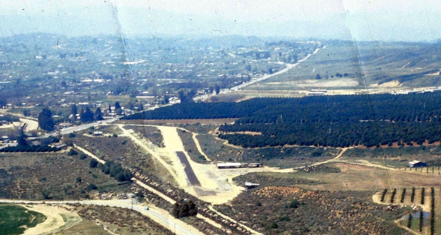
A 1967 aerial view by Doug Hammond (courtesy of Steven Clark) looking west at Crafton Hills Airport.
The runway & hangars remained intact, but the field was devoid of aircraft.
The eastern portion of the runway had evidently been paved with asphalt at some point between 1959-67.
A 1968 aerial photo Crafton Hills Airport remained unchanged.
The 1973 USGS topo map still labeled Crafton Hills Airport.
The 1975 USGS topo map still depicted the Crafton Hills Airport runway,
but it was labeled merely as “Landing Strip”, perhaps an indication that the airport had closed.
The 1980 USGS topo map no longer depicted the Crafton Hills Airport runway or any other airport features.
A 1980 aerial photo showed that the Crafton Hills Airport runway area was still clear, but less distinct.
Several T-hangars had been removed at some point between 1968-80, but one T-hangar remained.
A 1982 aerial photo showed that the Crafton Hills Airport runway area was still clear, one one T-hangar remained.
Jeremy Crooks recalled of Crafton Hills Airport, "I remember the building & windsock & runway as a child, some 30 years ago”, circa 1980s.
According to Sahara Diana Quinn, “Lincoln Field deteriorated over the years & the hangar was taken apart.
The property was sold to make way for the Chapman family of Irvine to develop the residential Chapman Heights development of homes.”
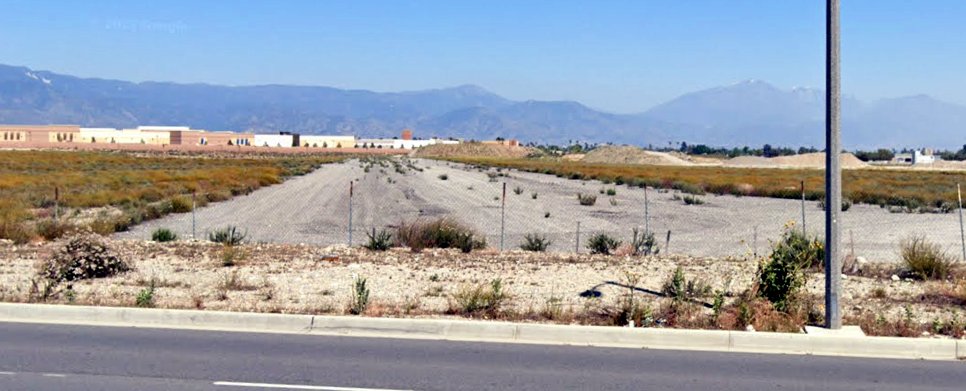
A 1995 aerial photo showed the last T-hangar had been removed at some point between 1982-95, erasing the last trace of Crafton Hills Airport.
According to Sahara Diana Quinn, “The site is now at the Yucaipa Golf Course.”
A 6/17/12 aerial photo shows a golf course community occupying the site of Crafton Hills Airport.ell).
The site of Crafton Hills Airport is located northwest of the intersection of Oak Glen Road & Yucaipa Boulevard.
Thanks to Jeremy Crooks for pointing out this airfield.
____________________________________________________
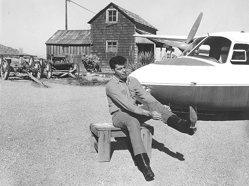
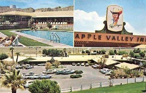
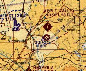
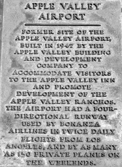
(Original) Apple Valley Airport, Apple Valley, CA
34.53, -117.22 (Northeast of Los Angeles, CA)
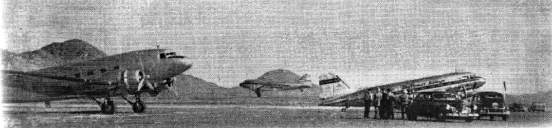
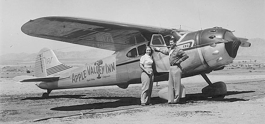
A photo of 3 DC-3s at the Apple Valley Airport, from the 3/24/49 Apple Valley News (courtesy of the Apple Valley Historical Advisory Committee).
The original airport for the town of Apple Valley was located adjacent to the north side of the town.
According to Dave Polson, “The Apple Valley Airport was built in 1948 by Newt Bass, at the same time he built the Apple Valley Inn.
At that time both were used by the Apple Valley Ranchos real estate company (both of which belonged to Newt Bass).”
According to “How the Apple Valley Airport Got Its Wings” by the Apple Valley Historical Advisory Committee,
“In 1949, the Apple Valley Airport was constructed on the north side of Highway 18, east of what is now Dale Evans Parkway.
It was conveniently located only 300 yards from the Apple Valley Inn.”
According to Mike 'Tex' Meeken, former salesman for the Apple Valley Building & Development Company,
“People used to fly in & walk across the Highway to the Inn for the ‘buck breakfast’ where the policy was all you could eat for a dollar.
It used to be a quite a thing”.
According to “How the Apple Valley Airport Got Its Wings” by the Apple Valley Historical Advisory Committee,
“Initially the airport consisted of a main east/west runway & an emergency, crosswind runway oriented roughly northeast/southwest.
Both appear to have been dirt at the airport's inception.
The only other feature was a tie-down area at the west end & just south of the main runway.
Access to the airfield was provided by a dirt road (eventually known as Airport Way) that extended from Highway 18.
The airport was extremely popular with visitors & residents of Apple Valley.
Many Apple Valley Inn guests flew in with their private planes.”
Apple Valley Airport was not yet depicted on the February 1949 LA Sectional Chart.
The earliest depiction which has been located of the original Apple Valley Airport
was a photo of 3 DC-3s from the 3/24/49 Apple Valley News (courtesy of the Apple Valley Historical Advisory Committee).
The photo was captioned “First Airline Lift to Movie Location".
The photo showed 3 Southwest Airway planes at Apple Valley Airport.
The Universal Pictures personnel were able to make the flight the previous Monday from Burbank to Apple Valley in a mere 25 minutes,
as compared to the 3-hour trip up the old Route 66 by bus or automobile.
Two days later, 7 C-47s brought up another 100 movie folks for the filming of "Swords in the Desert," on location in Apple Valley.

The earliest aeronautical chart depiction which has been located of Apple Valley Airport was on the September 1949 Sectional Chart,
which depicted Apple Valley Airport as having a 4,200' unpaved runway.
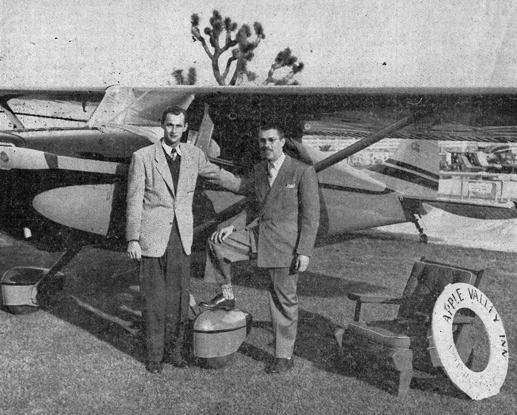
An undated photo from the 2/6/50 Western Pilot (courtesy of Lena Quinonez) of 2 men in front of a Cessna 170 at Apple Valley Airport.
According to “How the Apple Valley Airport Got Its Wings” by the Apple Valley Historical Advisory Committee,
“On a weekend in February of 1950, a story in the Apple Valley News noted that some 30 planes were visiting Apple Valley.
The Apple Valley Building & Development Company also owned several planes that were used to fly company VIPs across the country.
Two of the company planes included a twin-engine Aero Commander & a Cessna 195.”
A circa 1950s photo of a Twin Commander painted in Apple Valley markings (from “How the Apple Valley Airport Got Its Wings” by the Apple Valley Historical Advisory Committee).
A circa 1950s photo of a Cessna 195 painted in Apple Valley Inn markings (from “How the Apple Valley Airport Got Its Wings” by the Apple Valley Historical Advisory Committee).
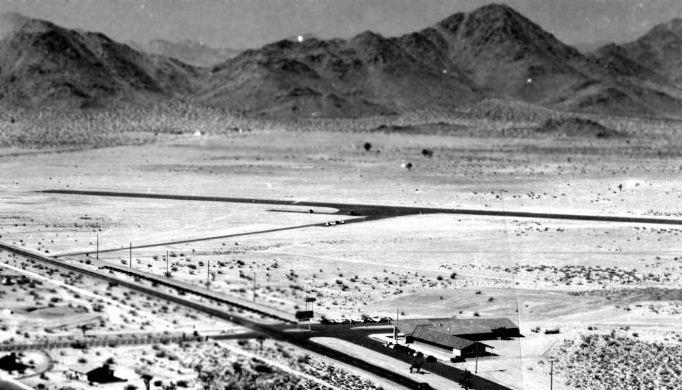
The earliest aerial view which has been located of Apple Valley Airport was a 1951 aerial view looking northwest (courtesy of Ray Dedrick via Paul Bern)
which depicted the field as having a single asphalt east/west runway.
According to Michael McMurtrey, "With regard to the original Apple Valley airport, if you want to see what it looked like,
take a look at any of the 'Sky King' episodes featuring the Cessna 310,
for stock footage of the Songbird landing at that airport was used in many of the episodes.
The house used as Sky's ranchhouse was across the main road to the south,
and the Songbird was routinely taxied across the main highway (California Route 18) to the house for filming!"
A 1951-59 photo of the Sky King Cessna 310 in front of “Sky's ranchhouse” across the street from the Apple Valley Airport (courtesy of Lena Quinonez).
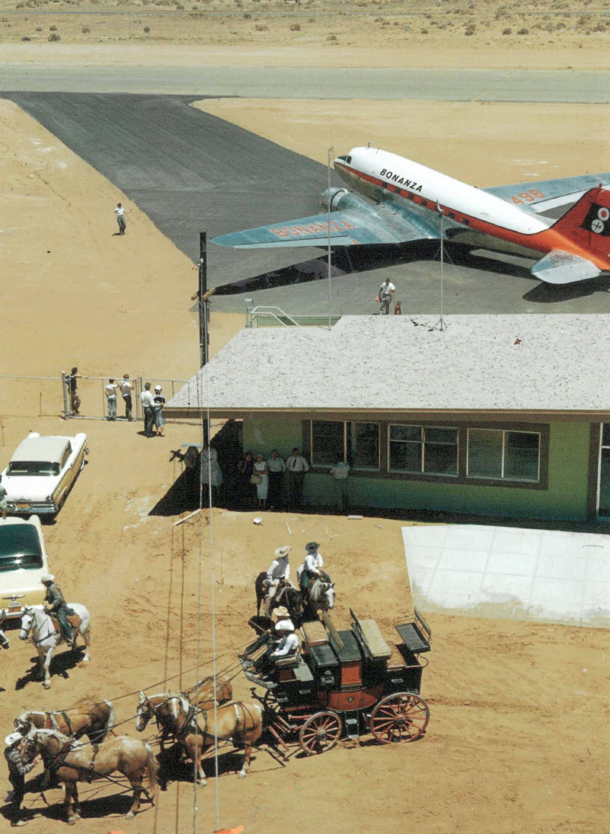
A circa 1950s photo of a horse-drawn wagon & a Bonanza Airlines Douglas DC-3 at the Apple Valley Airport (courtesy of Lena Quinonez).
A circa 1950s photo of a man & a Twin Commander at the Apple Valley Airport (courtesy of Lena Quinonez).
A 1/15/53 aerial view (from the UCSB Library) depicted Apple Valley Airport as having an asphalt east/west runway & a partially-paved crosswind runway.
Five single-engine aircraft were parked on the southwest side of the field.
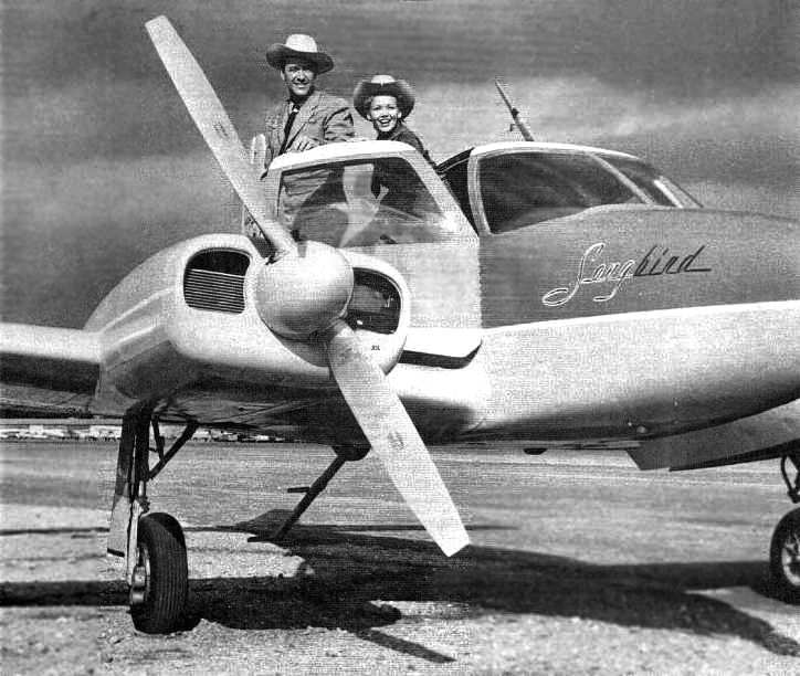
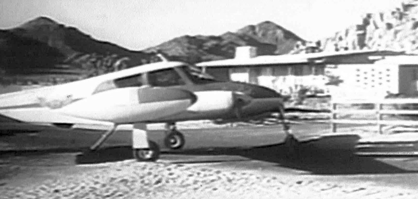
A circa 1956-58 photo (courtesy of Paul Bern, enhanced by Bill Grasha) of Kirby Grant (Sky King) and Gloria Winters (Penny)
on “Songbird II” (the Cessna 310 used for the “Sky King” TV series) at the Apple Valley Airport.
The 1957 USGS topo map depicted the Apple Valley Airport as having 2 paved runways, with several buildings on the southwest side.
In 1996, McMurtrey interviewed the pilot who flew the 310 for the Sky King filming, Bill Ferguson.
In Ferguson's words, "There came a series of special location shots, and these were the most interesting ones,
because they could be anything from low flying, buzzing a house, or something like that,
to landing on the desert on a dry lake bed, to flying with one engine shut down over some mountains.
Most of those, we were based at the Apple Valley Air Strip at the Apple Valley Inn, out in the desert.
That strip was right along the highway, and it was right in the front of the Apple Valley Inn, where we stayed.
It was just a real nice little strip."
According to Paul Bern, Sky King “was filmed in Apple Valley & in a LA sound stage from 1951-62.”
Brian Baker recalled, "On the Apple Valley field, I landed there once, about 1963 or 1964,
in my Luscombe, and recall asking the lineboy to prop the engine for me.
It was an old 65 with Armstrong starter.
I called 'contact' as the engine was still warm & always started right up,
and the guy got out in front & proceeded to start turning the prop BACKWARDS.
I got rid of him & did it myself. Only time that ever happened to me."
The 1964 LA Sectional chart (courtesy of John Voss) depicted Apple Valley Airport as having one runway (oriented east/west),
but the Aerodromes table on the reverse side of the chart
described the field as having 2 asphalt runways (with the longest being 4,125'),
along with the remark "North end of north/south runway broken."
An undated postcard of Roy Rogers' Apple Valley Inn (courtesy of Dan MacPherson, enhanced by Bill Grasha).
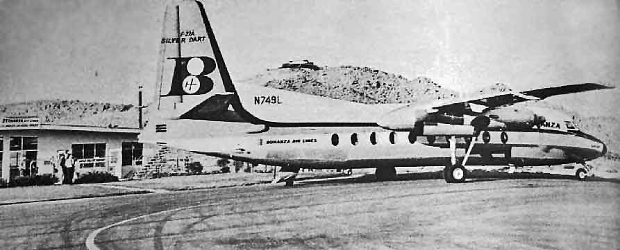
A 1964 photo from a 1964 LA Times supplement entitled "The Apple Valley Story" (courtesy of Richard Thompson, via Paul Bern, enhanced by Bill Grasha)
of a Fokker F-27A "Silver Dart", pictured at the original Apple Valley Airport.
The photo's caption was "Bonanza Airlines serves Apple Valley with 4 flights daily - between Los Angeles & Las Vegas."
A 6/3/68 USGS aerial view depicted the original Apple Valley Airport as having a paved east/west runway & a dirt crosswind runway.
Several dozen light aircraft were parked on the southwest side of the field, but strangely the airport did not appear to have any hangars.
As depicted on the 1969 USGS topo map, the Apple Valley Airport consisted of a single 4,100' east/west runway.
The last aeronautical chart depiction which has been located show the original Apple Valley Airport in operation was on the March 1969 LA Sectional Chart.
As the town of Apple Valley expanded around the original airport,
a new site was chosen farther out of town, which would also provide for a longer runway.
The newly Apple Valley County Airport (3 miles northeast)
was built in 1970, at which point the original airport presumably closed.
The original Apple Valley Airport was depicted as an abandoned airfield
on the 1972 World Aeronautical Chart (courtesy of Scott O'Donnell).
The original Apple Valley Airport was no longer depicted at all on later USGS topo maps (only the former airport entrance road).
According to Shelley Presswood (who was born in Apple Valley),
the row of buildings along the north side of the runway (along Thunderbird Road)
"are apartments, built from around 1978-82 or slightly later."
According to “How the Apple Valley Airport Got Its Wings” by the Apple Valley Historical Advisory Committee,
“In the late 1980s the old airfield including a portion of of the main runway was demolished
abd removed in preparation for the construction of of the Rancherias Plaza shopping center & an adjoining retention basin.
On 1/23/88 a mock disaster crash was staged at the airport.
The multi-agency exercise resulted in the complete destruction of the airport terminal.
The only vestige of the building left standing at the time was the frame of the weather station.”
An undated photo of a plaque which commemorated the original Apple Valley Airport.
According to “How the Apple Valley Airport Got Its Wings” by the Apple Valley Historical Advisory Committee,
“In the early 1990s the developers of the Rancherias Plaza (former Ralph’s grocery store) were asked to commemorate the location.
A plaque was installed at the base of the flag pole in the shopping center located on the north side of Highway 18 just east of Rancherias.”
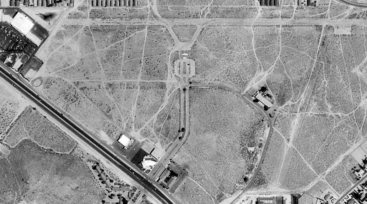
As can been seen in a 1994 USGS aerial photo, a majority of the former original Apple Valley Airport still remained.
A shopping center had been built over the western end of the former east/west runway,
but a 3,800' length of the runway still remained in a somewhat deteriorated fashion, along with the ramp south of the runway midpoint.
The former crosswind runway (oriented northeast/southwest & intersected the primary runway near its eastern end)
was much more deteriorated than the primary runway, and a shopping center had also been built over its southern end.
A circa 2000-2005 aerial view looking north at the remains of the Apple Valley Airport ramp & runway.
Roy Rogers' Apple Valley Inn was advertised for sale in an Internet auction in 2003.
The property was described as having been used most recently as a long term care & medical facility,
and some portions of the property were described as being "in need of rehab".
Dan MacPherson visited the site of Apple Valley in 2003 & walked the runway.
He reported, "Little has changed since 2001.
I also looked at the Apple Valley Inn, across the street, and saw the 'Hilltop House' overlooking the works.
There was a structure connected with the airport across the new road, I did not stop to see it.
The Inn is in poor shape & the airport is destined to be a mall (sigh).
Such historical property, and very beautiful-rolling hills & such.
It obviously should be preserved but that won't happen. It just tears my heart out to see that stuff being demolished.
Also the population surge out here - none of the things California is known for will survive."
Dan added later in 2003, "I went back this weekend. The Apple Valley Inn across the street is intact.
Most rooms are abandoned but a few people still live there.
The Inn has little cottages such as 'The Bob Hope Cottage' which I photographed.
Now is the time to see this stuff. It will be gone soon."
A majority of the original Apple Valley Airport's east/west primary runway still remained as of a 2005 aerial view.
Paul Bern reported in 2006, “The Apple Valley Inn was sold in 2005 approximately
and the new owners have spend a lot of money refurbishing the place.
From what I have been told, the new owners are looking to preserve as much of the original look as possible.
It appears that they are renting out some of the rooms to small businesses like real estate offices & the like.
So for now the Inn in some of its glory will still be with us.”
Paul continued, “I personally found the house that was used in the Sky King series.
It still exists! It is located on Rancherias Road, south of Highway 18
about a quarter of a mile on the left, just past the golf course.
It has been completely refurbished on the outside & the only way to recognize it is by the stone fireplace.
It is the only thing that they did not change.
It is great seeing it as I was a kid with dreams of flying like Sky King.”
Charles Irvin reported, “Apple Valley Airport: I passed through there last November [2006], and there was construction going on there.
I was told by a friend that lives there that they built a Home Depot on the location.
Sad, but at least I can say that I walked the entire location before it vanished.”
Louis Delrio reported in 2011, “There is a little restaurant in Apple Valley located on the northeast corner of Bear Valley Road & Apple Valley Road called 'Johnny D's'.
It contains many Apple Valley Inn items including part of the original sign
and a photo that was taken circa 1964 that clearly shows the original airstrip with numerous general aviation aircraft.”
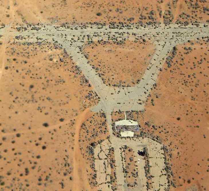
A 2013 photo by Anne Collier looking northeast along the remains of the Apple Valley pavement.
Anne reported, “I went looking for the remnants of the Apple Valley Airport runway and found it located north of the abandoned Lowe's building.
It's really deteriorated & chunked up in places from when construction crews built the building.”
Blaine Hopkins reported in 2014 of the original Apple Valley Airport, “A few hundred feet of the former entry road from the highway still exists (now called Wakita Boulevard)
and a small portion of the road still also sits directly next the the building.
They no longer connect however, since buildings have been developed in between.”
Amazingly, a 2020 aerial photo show that recognizable portions of the the original Apple Valley Airport's east/west primary runway still remained recognizable, on the northeast portion of the site.
The site of the original Apple Valley Airport is located north of the intersection of Happy Trails Highway & Apple Valley Inn Road.
____________________________________________________
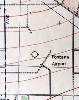
Fontana Intermediate Field / Fontana Airport, Fontana, CA
34.148, -117.423 (West of San Bernardino, CA)
Fontana Intermediate Field, as depicted on the June 1932 LA Sectional Chart.
Fontana Intermediate Field was one of the Commerce Department's network of airfields set up along Airways between major cities,
intended for emergency use by early commercial aircraft.
Bret Kepner reported, “One hundred acres of land was leased to the government in March, 1930,
but the planned dedication & opening on 8/15/30 was delayed by a variety of problems and the airport didn’t open until 4/11/31, for mail & passenger service.
This airfield had 3 runways, all of which appeared to be unpaved: 2,600' north/south, 2,200' east/west, and 2,700' northeast/southwest.
It appears to have been operational in 1930 & was referred to as 'Fontana Emergency Landing Field'.”
The earliest depiction which has been located of Fontana Intermediate Field was on the June 1932 LA Sectional Chart.
It depicted an commercial/municipal airport, labeled simply "LF" (Landing Field).
By the time of the October 1933 LA Sectional Chart, it was labeled Fontana Airport.

The earliest topo map depiction which has been located of Fontana Intermediate Field was on the 1936 USGS topo map.
It depicted “No. 5 Department of Commerce Fontana Intermediate Landing Field” as a property outline with an Airway Beacon & a small building on the southeast side.
The Airport Directory Company's 1937 Airports Directory (courtesy of Bob Rambo)
described the Commerce Department Intermediate Field at Fontana, "Site 5, LA-Amarillo airway".
It was described as having a triangular sand & gravel landing area, measuring 2,640' x 2,227'.

The last aeronautical chart depiction which has been located of Fontana Airport was on the December 1938 LA Sectional Chart.
The earliest photo which has been located of Fontanta Airport was a 1938 aerial view.
It depicted the field as having 3 unpaved runways, with an unpaved parking area & a small building on the southeast side.
Fontana Airport was evidently closed at some point between 1938-39,
as it was no longer depicted on the November 1939 LA Sectional Chart, which only continued to depict the Airway Beacon, not the airfield.

The 1941 USGS topo map depicted “Fontana Airport” as a property outline with a Beacon & a small building on the southeast side.
The last topo map depiction which has been located of Fontana Airport was on the 1942 USGS topo map (courtesy of Kevin Walsh).
It depicted “Fontana Airport” as having a small building on the southeast side.

The last map depiction which has been located of Fontana Airport was on a 1947 street map (courtesy of Kevin Walsh).
It depicted “(Formerly) Fontana Airport” as a square property outline.

A 1948 aerial view showed all traces of Fontana Airfield had been erased at some point between 1938-48,
with what appear to be a large complex of ammunition bunkers covering the property.
The ammunition bunkers covering the Fontana Airport site appeared in aerial photos as late as 1995.
A 2002 aerial photo show that they were removed, with the property having become a landfill.

A 2023 aerial view looking north showed no trace remained of Fontana Airfield, with the property covered by a landfill.
As of 2024, street maps label the site of Fontana Airport as the Mid-Valley Sanitary Landfill.
It is located southwest of the intersection of Summit Avenue & North Adler Avenue.
Thanks to Bret Kepner for pointing out this airfield.
____________________________________________________
Cal-Aero Airport / Fontana Gilfillan Airport, Fontana, CA, Fontana, CA
34.13, -117.47 (West of San Bernardino, CA)
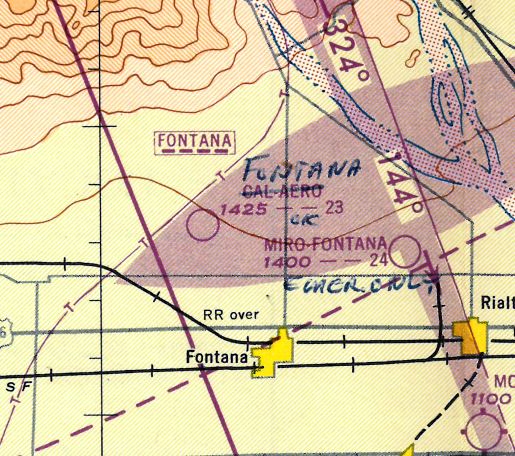
Cal-Aero Airport, as depicted on the 1947 LA Local Aeronautical Chart (courtesy of Tim Zukas).
No airfield was yet depicted at this location on a 1938 aerial view.
Bret Kepner reported, “Cal-Aero Auxiliary Field was constructed by the government, opening on 4/6/44, and operated by the government during the war.”
Lane Leonard recalled, “Fontana Gilfilan... During WWII this airport was used as a night training field for the Cal Aero Cadets.
The runways were lined with a small smudge pot type of device. Aircraft were BT & Stearman.
I learned this through my Father who instructed there at Cal Aero at the start of WWII.”
Bret Kepner reported, “Cal-Aero was reopened as a civilian facility after being purchased from the government’s War Assets Administration on 12/23/46, by the San Bernardino Board of Supervisors
and then leased to Robert Gambrell who opened it as the Fontana Airport on 11/14/47.”
Fontana Airport was not yet depicted on the February 1947 LA Sectional Chart.
The earliest depiction which has been located of Cal-Aero Airport was on the 1947 LA Local Aeronautical Chart (courtesy of Tim Zukas).
It depicted Cal-Aero as having a 2,300' unpaved runway.
Bret Kepner reported, “Gilfillan’s northeast/southwest runway was paved & opened in 1948.”
The earliest photo which has been located of Fontana Airport was a 1948 aerial view.
It depicted the field as having 2 very wide but short, parallel, paved runways,
along with what appeared to be a former unpaved crosswind runway.
Several small buildings were located on the north side of the field, near which was visible a total of 5 single-engine aircraft.
Fontana Airport was depicted as an active airfield on the 1950 LA Sectional Chart (according to Bob Cannon).
According to drag racing historian Bret Kepner, Fontana was used as a dragstrip in 1950-52,
so it must have been barely active as an airfield at that time.
In the 1950s, Fontana Airport became the site of radar testing flight operations for the Gilfillan Brothers, pioneers in the development of GCA radar.
According to Donald Chantry (Gilfillan Brothers & ITT Gilfillan employee from 1954-91),
"This Airport did not become a significant part of the Gilfillan Brothers activity until just a few years before my joining them in 1954."
The 1954 USGS topo map depicted Gilfillan Airport as having 2 wide but short paved parallel east/west runways, with a single small building on the north side.
According to Donald Chantry, Gilfillan Electric was chosen to further develop & produce
the MPN-1 Ground Controlled Approach (GCA) radar (which had been initially developed by MIT during WW2).
Fontana Airport was used to test the enormous number of CPN-4 & MPN-11 radar systems eventually produced by Gilfillan.
An antenna test site was constructed at the southeast corner of the field,
and thousands of test flights were conducted to support radar testing.
Donald Chantry recalled, "During the height of the operations at Fontana,
many different aircraft were used to test the capability of our radar equipment.
On one series of tests on the Quad Radar, the 4-engine C-124 GlobeMaster II had to make simulated approaches on Runway 9.
It had to make a touch & go, and get airborne by the time it crossed the east boundary of the field
and clear the houses on the other side of the fence.
One day as the airplane had just roared over the end of the field,
the telephone could be heard ringing & a very irate voice could be heard over the intercom to say,
'I works for de Kaiser & I needs my sleep'. I can imagine the window rattling roar those engines must have caused."
Donald continued, "I do remember that the requirement was for the aircraft to make a GCA approach
under control of the GCA final controller to the point where the aircraft was at or about touchdown, to check accuracy, controllability, etc.
And then to have the aircraft recover from the decent & gain full flying speed & altitude
and climb away from the end of that short runway.
And you can just imagine the racket those big R-4360 engines made as they passed over the field."
Ernie Gesner recalled from 1959, "I remember practicing engine out landings at Fontana Gilfillan Field in a Cessna 150
and that runway was in bad shape as the instructor made me do go-arounds & not land due to the runway conditions."
A 1959 aerial view depicted the northern east/west runway marked prominently with large Xs & “Closed” on each runway end.
There were no aircraft visible on the field.
Fontana Airport was listed among active airfields once again in the 1962 AOPA Airport Directory.
It was described as having 2 runways: a 3,100' oiled Runway 4/22 & a 2,150' roadmix Runway 9/27,
and the operator was listed as Gilfillan Brothers Inc.
Don Perry recalled, “I was hired by Gilfillan Brothers at their main plant on Venice Boulevard in LA in 1963 for field service work.
My first task was working evening shift on post-production testing of GCA radar systems at the Gilfillan/Fontana Airport.
In 1963 the area around the Gilfillan/Fontana airport had not changed significantly from the photograph [below] of the 2 B-25s flying overhead
except for growth of scrub brush & small trees outside the airport perimeter.
There were still the scattered, small houses to the east with people living there.”
Don continued, “The twin Beach mentioned was based at a more established facility & had a contract to fly patterns toward LA for us.
The pilot would contact us by UHF radio at about 7pm & flew ascending patterns until the 'low altitude' portion was completed well after dark.
At that point we would break to eat.
The twin Beach was normally aspirated & required the better part of an hour to reach 10,000' where the last pattern was flown.
He would sometimes complain about having to carry the military ARC-27 radio, a weight penalty, for our communication link.
One time, when asked to make a turn, he said he did not want to bank because he would lose altitude.
The pilot was usually alone but would occasionally have someone with him.
A second pilot may have been someone along to build time.”
With the spelling of "Fontana Gilfillian", it depicted as an active private airfield on the August 1964 LA Local Aeronautical Chart (courtesy of Donald Felton)
and the 1965 LA Local Area aeronautical chart (courtesy of John Voss).
Lane Leonard recalled, “There was a B-25 that sat on the airport well into the 1960s.
I remember as a High School kid being impressed by the B-25.”
Another Gilfillan GCA radar which was tested at Fontana was the AN/FPN-36 "Quad Radar",
a unique, compact, transportable radar unit that could be used as a GCA, ASR (terminal area radar),
ASDE, and height finder (ASR approach was considered part of the GCA capability).
Thousands of approaches to Fontana Airport were conducted by a Beech 18 aircraft
to test & validate the equipment.
John Hazlet recalled that "In the late 1960s, I shot hundreds of GCA (now called PAR) approaches
in DC-3s at Navy San Nicolas Island (NSI), using the prototype FPN-36."
Former Gilfillan Brothers employee William Parrott recalled,
"The Fontana site was set up when the previous site at Ontario Airport became too busy.
Among other things, the airport was used as a test site for missile electronics, which were flown in a contracted Beechcraft.
[I have] a lot of memories, such as the Beechcraft getting lost in a sudden fog,
and a group of us hand-rotating a large Corporal missile antenna out in the rain to give the pilot a vector back to the airport.
There was a 3-story range test tower on the southeast corner of the airport.
Radar needs to be tested on a large, open area. The airport was taken out of CAA/FAA service because of the high winds.
Some employees would actually drive out there on 'windy' days to allow the sand to blast the car's paint, resulting in a new paint job.
Insurance companies didn't like us."
Donald Chantry recalled, "And yes the wind could & did blow.
One day an Army light observation plane was attempting to make a landing at the airport
but the wind was too strong out of the north so the pilot simply landed crossways on the north east/west runway."
Donald Chantry recalled, "In the years after ITT purchased the company [in 1964],
Fontana was used as a test site for various other electronic equipment."
Several buildings on the ramp on the north side of the airfield
"were used as school rooms for training company & military personnel & as final assembly & repair areas."
Donald Chantry recalled, "The population was moving too close to the perimeter of the field to allow safe operations, and the heyday of GCA was over.
After Gilfillan removed their sign the field was used by model airplane flyers
and for some type of produce drying on the north east/west runway.
In later years (after Gilfillan) the runways were in sad repair due to holes along the edges.
So it is a little strange that it was not decommissioned & taken off of the charts."
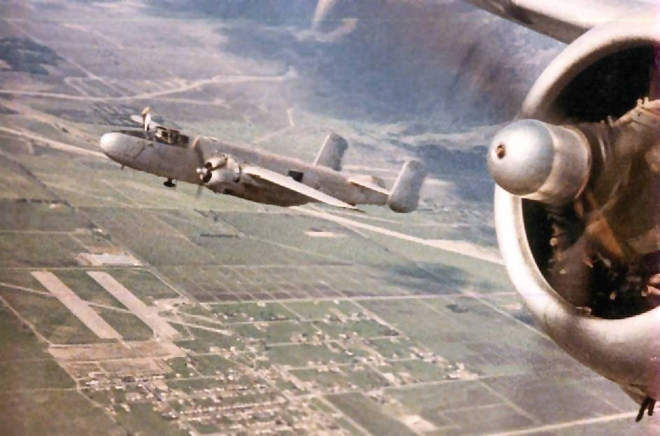
A fantastic aerial view by Dan MacPherson (enhanced by Bill Grasha) of Eisenhower's former B-25 Mitchell
(flown by the Chino Planes of Fame Air Museum) overflying Gilifillan Airport (lower left corner).
The photo was taken from the Planes of Fame B-25 "Photo Fanny".
According to Dan, "After this flight I drove to the field, which was on the south side of Highland.
The wide runways appeared too short to land on. I was told the runways were used for radio controlled drones.
You could land on the long cross runway if you wanted to. I spoke to someone who attended a drag race there."
Don Perry recalled, “In 1967 I was, again at the Gilfillan Airport attending classes on another, newer piece of GCA equipment.
Nothing had changed. Various prototype, production and overhaul projects were tested & proved there.
At one point I was told that Gilfillan leased the airport form the city of Fontana for $1/year.
I imagine that was above & beyond up-keep & taxes.”
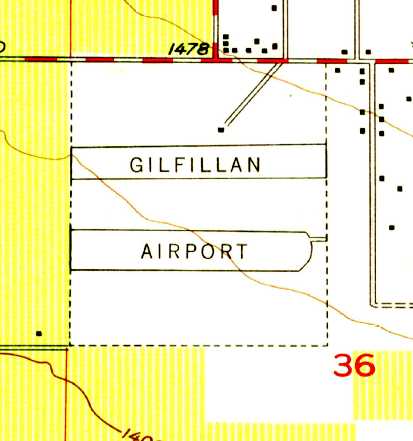
The airfield was labeled "Fontana Gilfillan" Airport on the 1969 USGS topo map.
Fontana Airport, as depicted on the September 1971 USAF Tactical Pilotage Chart (courtesy of Chris Kennedy).
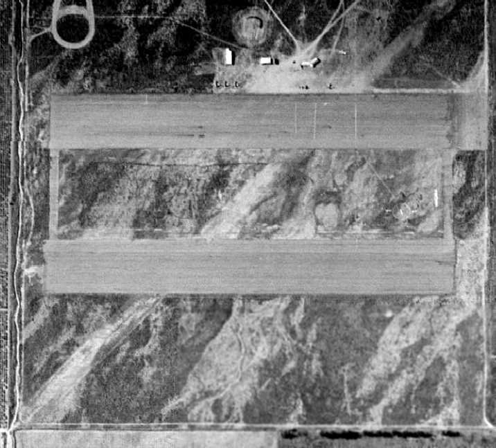
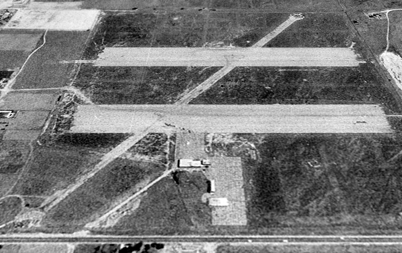
A circa 1970s aerial view of looking northeast at Fontana Airport (enhanced by Bill Grasha) showed the field to have 3 paved runways, each of which were painted with closed “X” symbols.
There were no aircraft visible on the field.
A 1980 aerial view of Fontana Airport showed that the crosswind runway had been paved at some point between 1948-80.
But all 3 runways were painted with closed “X” symbols, and there were no aircraft visible on the field.
The last aeronautical chart depiction which has been located of Fontana Airport
was on the August 1980 LA Terminal Aeronautical Chart (courtesy of Mitchell Hymowitz).
It depicted Fontana Airport as a private airfield having 3 paved runways, with the longest being 3,100'.
According to David Nimmo, “I believe that it was shut down [for reasons unknown] in 1988 or 1989.
In 1990 it was depicted on the LA Sectional & Terminal Charts as closed
but was still identifiable & used for navigation purposes.”
A 1994 USGS aerial view looking south at Fontana Airfield showed the 3 paved runways still remained,
along with 2 paved ramps on the north side of the airfield, on which sat a few buildings (previously used by ITT as classrooms & assembly buildings).
The 3 runways of the airfield were still depicted on the 1998 USGS topo map, labeled Gilfillan Airport.
Bret Kepner visited the Fontana Airport site in 2001, only to be "sickened…
to find it had been completely wiped out by a subdivision the previous month.
The last memory is the entry street's name - Gilfillan Drive."
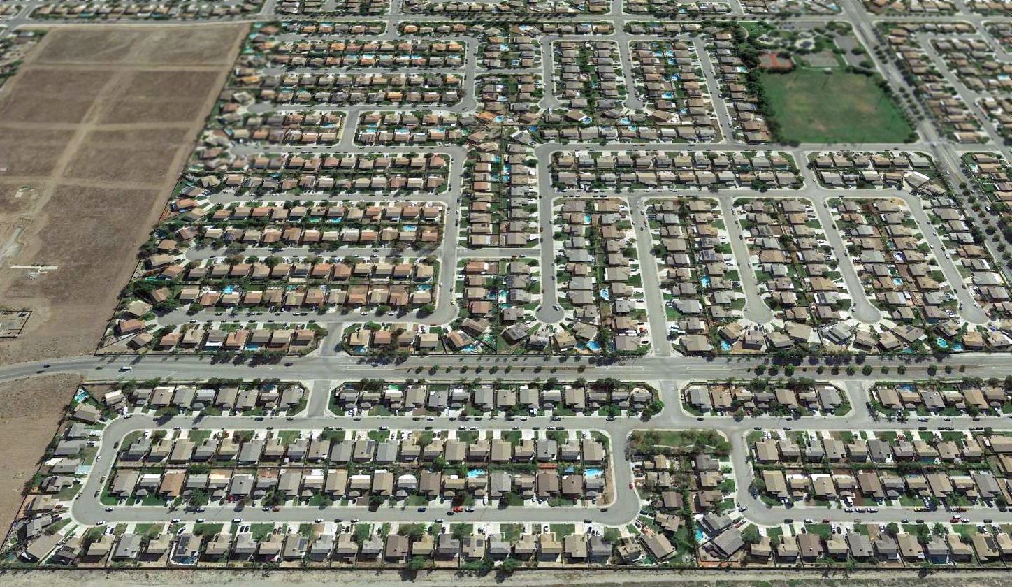
A 2016 aerial view looking south at the site of Fontana Airfield showed no trace remaining of the airport -
yet another piece of aviation history covered by America's seemingly insatiable appetite for suburban housing.
The site of Fontana Airport is located southeast of the intersection of South Highland Avenue & Beech Avenue.
____________________________________________________
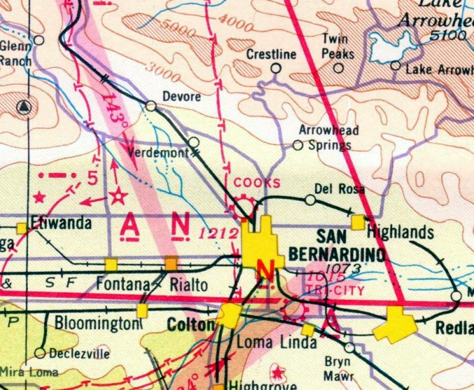
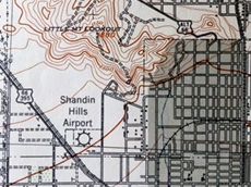
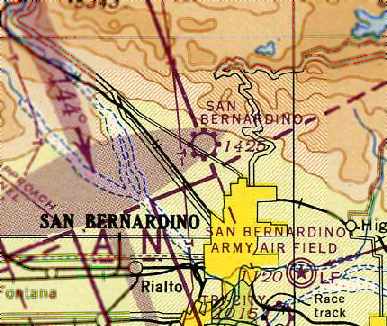
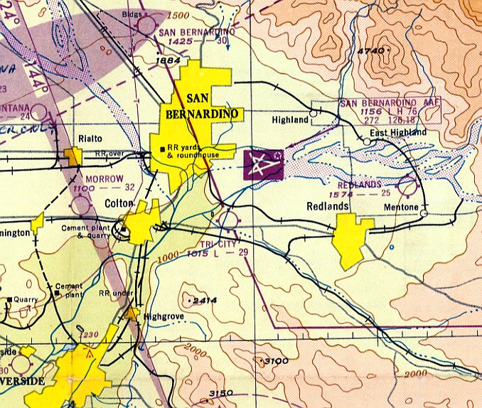
San Bernardino Airport (1st location) / Shandin Hills Airport / Cooks Airport,
San Bernardino, CA
34.14, -117.31 (Northwest of San Bernardino International Airport, CA)
The original location of the San Bernardino Airport,
as depicted on the 1929 "Rand McNally Standard Map of CA With Air Trails" (courtesy of Chris Kennedy).
The date of construction of the original location of San Bernardino Airport has not been determined.
The earliest depiction of the field which has been located
was on the 1929 "Rand McNally Standard Map of CA With Air Trails" (courtesy of Chris Kennedy).
It described the San Bernardino Airport as being operated by L.S. Miles,
having a 2,200' runway, and being located 2 miles west of the city of San Bernardino.
The San Bernardino Airport evidently closed at some point between 1929-32,
as it was no longer depicted on the June 1932 LA Sectional Chart (according to Chris Kennedy).
In 1932, another airport opened in very close proximity to, if not the same location as the previous airport, called Shandlin Hills Airport.
According to Mark Sublette, “The San Bernardino Daily Sun reported on 10/21/32
that Shandin Hills Airport in San Bernardino would be dedicated on 10/22/32
and that the Chamber of Commerce was placing a special cancellation & the signature of airport manager William Angel on several hundred covers
to be remailed to aviation fans & stamp collectors around the country.”
A small display advertisement in the 10/22/32 San Bernardino Daily Sun read (according to Mark Sublette),
“AIR MEET, Shandin Hills Airport, Mount Vernon & 27th Streets.
Parachute jumps, stunt flying, night flying & many other thrilling attractions.”
The earliest aeronautical chart depiction which has been located of this airfield was on the August 1933 LA Sectional Chart.
Note that it apparently misspelled the airport name, as “Shannon Hills”.
The October 1933 LA Sectional Chart correctly spelled the airport name, as “Shandin Hills”.
However no airport in San Bernardino was listed in The Airport Directory Company's 1933 Airport Directory (according to Chris Kennedy).
The 1934 Department of Commerce Airport Directory (according to Chris Kennedy)
described the Shandlin Hills Airport as being located 1.5 miles northwest of the city of San Bernardino.
It was still depicted as Shandin Hills Airport on the July 1935 LA Sectional Chart.

At some point in 1935, Shandin Hills Airport was renamed Cooks Airport,
as that is how it was depicted on the December 1935 LA Sectional Chart.
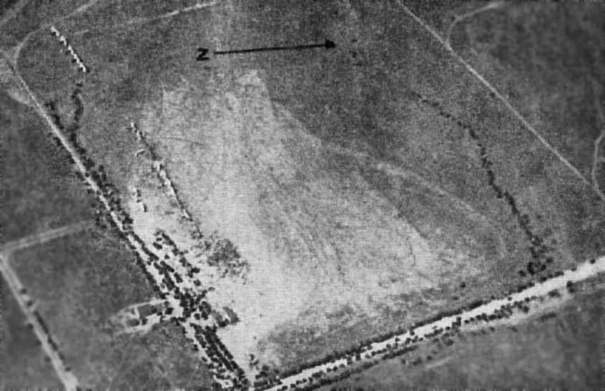
The earliest photo which has been located of Cooks Airport was an undated aerial view looking west (enhanced by Bill Grasha)
from The Airport Directory Company's 1938 Airport Directory (courtesy of Chris Kennedy).
It depicted Cooks Airport as consisting of a square unpaved area, with a row of planes along the southern edge.
The directory described Cooks as a commercial field consisting of a 70 acre irregularly-shaped sod field.
Hangars in the southeast corner were said to be marked with “Cooks Airport”.
It was still depicted as Cooks Airport was on the November 1939 LA Sectional Chart.
At some point between 1938-41 the airfield was renamed back to Shandin Hills,
as that is how it was listed in The Airport Directory Company's 1941 Airport Directory (courtesy of Chris Kennedy.
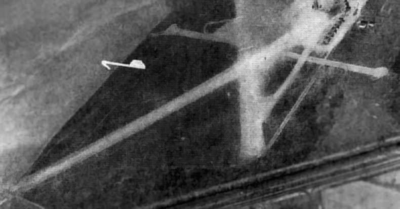
An undated aerial view looking east at Shandin Hills from the 1941 directory (enhanced by Bill Grasha)
depicted Shandin Hills as having several distinct unpaved runways.
The directory described Shandin Hills as a commercial field consisting of a 70 acre irregularly-shaped sod field.
The field was said to have 3 runways (with the longest being the 2,200' northwest/southeast strip), and to have hangars in the southeast corner.
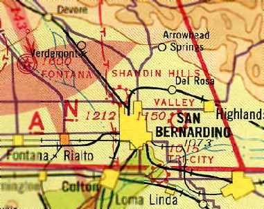
The last aeronautical chart depiction which has been located of Shandin Hills Airport
was on the October 1941 LA Sectional Chart (courtesy of Chris Kennedy).
The Shandin Hills Airport evidently closed (for reasons unknown) at some point between 1941-42,
as it was no longer depicted on the April 1942 LA Sectional Chart.
Shandin Hills Airport was still depicted on the 1942 USGS topo map (courtesy of Kevin Walsh).
The last depiction which has been located of the Shandin Hills Airport
was on a 1943 street map (courtesy of Dan MacPherson), which depicted both Shandin Hills Airport (to the south)
as well as the San Bernardino airport (to the north).
However, the Shandin Hills Airport was already closed by this point.
A 1959 aerial view depicted the remains of the Shandin Hills runways, but several roads had been built across them.
Remains of the runways were still recognizable in a 1968 aerial view, but less intact.
A 1980 aerial view showed that the site of Shandin Hills Airport had been redeveloped with housing & roads,
and not a trace of the airport appeared to remain.
As seen in a 2006 aerial photo, the site of Shandin Hills Airport had been redeveloped with housing & roads,
and not a trace of the airport appeared to remain.
The site of the Shandin Hills Airport is located north of the intersection of Cajon Boulevard & West Highland Avenue.
____________________________________________________
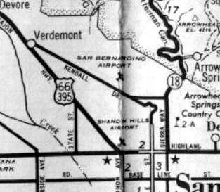
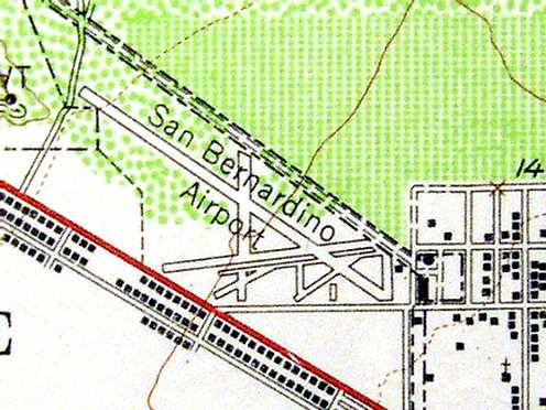
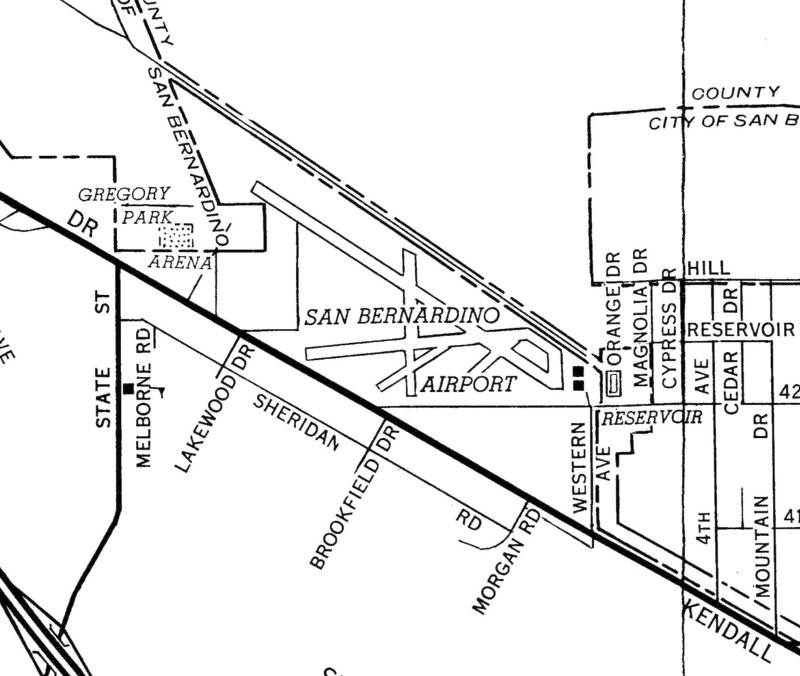
San Bernardino Airport (2nd location), San Bernardino, CA
34.173, -117.319 (Northwest of San Bernardino International Airport, CA)
The 2nd location of the San Bernardino Airport, as depicted on a 1943 street map (courtesy of Dan MacPherson).
At some point between 1942-43, a second location of the San Bernardino Airport was evidently established, approximately a mile north of its original location.
The earliest depiction depiction which has been located of the 2nd location of the San Bernardino Airport was on a 1943 street map (courtesy of Dan MacPherson).
However, the San Bernardino Airport was not depicted at all on the 1944 LA Sectional Chart (courtesy of John Voss),
nor listed in the 1945 AAF Airfield Directory (courtesy of Scott Murdock), which may indicate that it was temporarily closed during WW2.
The earliest aeronautical depiction depiction which has been located of the 2nd location of the San Bernardino Airport
was on the August 1945 LA Sectional Chart (courtesy of Chris Kennedy).
It was depicted as a commercial/municipal airport.
The San Bernardino Airport was depicted as an auxiliary airfield on the 1946 LA Sectional Chart (courtesy of Dan MacPherson).
The 1947 LA Local Aeronautical Chart (courtesy of Tim Zukas) depicted San Bernardino Airport as having a 3,000' unpaved runway.

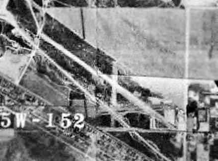
The earliest photo depiction of the 2nd location of the San Bernardino Airport which has been located was a 6/29/48 USGS aerial view (enhanced by Bill Grasha).
It depicted the field as having a single east-northeast/west-southwest runway,
along with several diagonal runways or taxiways on the south side of the primary runway.
A 7/11/52 USGS aerial view depicted the 2nd location of the San Bernardino Airport e field as having a single east-northeast/west-southwest runway,
along with remains of several diagonal runways or taxiways on the south side of the primary runway.
Five light aircraft were parked near some small buildings on the southeast side.
The configuration of the old San Bernardino Airport was changed considerably at some point between 1949-54,
as the 1954 USGS topo map (courtesy of Scott O'Donnell) showed that a much longer (3,700') northwest/southeast runway had been added.
Former San Bernardino resident Al Billings recalled, "I remember it from childhood, circa 1955. I remember the old hangar & a wind sock.
It was located north of Kendall Drive, above 48th Street, on the south edge of the present college campus.
Later on, the California Division of Forestry used it to base a spotter plane, an old Avenger. I can still hear the rumble of its engine as it flew overhead."
A 1959 aerial view depicted 4 light single-engine aircraft parked on the ramp at the southeast corner of San Bernardino Airport.
A 1961 street map (courtesy of Frank Acosta) depicted San Bernardino Airport as having 3 runways & several taxiways.
In a 1961 aerial view of the old San Bernardino Airport (courtesy of Bob Anderson, enhanced by Bill Grasha) it was not apparent if the field was still operational at that point.
The last aeronautical depiction depiction which has been located of the 2nd location of the San Bernardino Airport
was on the May 1961 LA Local Aeronautical Chart (courtesy of Ron Plante).
It depicted San Bernardino as having a 4,000' unpaved runway.
The 2nd location of the San Bernardino Airport was apparently closed at some point between 1961-63,
as it was no longer depicted at all on the March 1963 LA Local Aeronautical Chart (according to Chris Kennedy).
Several roads had been cut through the airport site in a 1968 aerial view, but 2 hangars still remained standing on the east side of the site.
A 1980 aerial view still showed small traces of some former runways, and 2 hangars still remained standing on the east side of the site.
According to Dan MacPherson, "a friend went to a hardware store (long gone) that was a hangar from the airport."
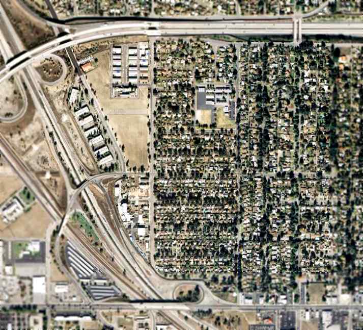
A circa 2001 aerial photo showed the former hangars had been built-over with housing at some point between 1980-2001.
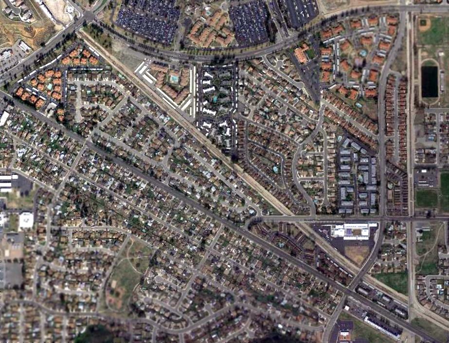
No airport remains were still perceptible in a 2016 aerial view of the 2nd location of San Bernardino Airport.
In the words of Al Billings, "I still go out there every year, and I miss seeing the old airport.
I hate to see all that old, beautiful infrastructure destroyed. All southern California can think to do is grind it flat & put tract houses on it.
It was a time when flight was on a very humble & human scale, and the runways, planes, and buildings were pleasing to the eye."
The site of the old San Bernardino Airport is located north of the intersection of Kendall Drive & West 48th Street.
____________________________________________________
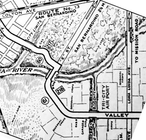
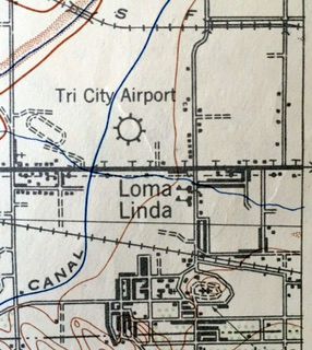
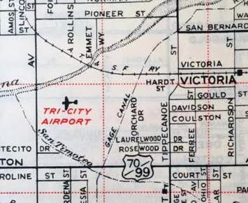
Tri-City Airport (SBT), San Bernardino, CA
34.067, -117.272 (East of Los Angeles, CA)
Tri-City Airport, as depicted on the 1929 "Rand McNally Standard Map of CA With Air Trails" (courtesy of Chris Kennedy).
According to the book "Images of San Bernardino California" (via Beverly Phillips),
Tri-City Airport was opened in 1927 by W.H. Lines.
Beverly's father was a student at San Bernardino High School in 1927 when 100 of them were recruited to go to Tri-City Airport
and pose shoulder to shoulder atop an airplane for a commercial photo,
to be used for an advertisement for a company that wanted to build airplanes in San Bernardino.
The Standard Oil Company's 1929 "Airplane Landing Fields of the Pacific West" (courtesy of Chris Kennedy)
described Tri-City Airport as being operated by W. H. Lines.
The airfield configuration was said to 2 runways, in an "L" shape, with the longest being a 3,600' east/west strip.
Two large hangars were said to be on the south side of the field, along with 5 smaller hangars in the southeast corner.
The 1930 "Southern California At A Glance" (courtesy of Kevin Walsh) depicted Tri-City Airport as a rectangular property outline.
A circa 1930s aerial view looking west at Tri-City Airport (courtesy of Kevin Walsh), showing an arched-roof hangar & a row of T-hangars.
The earliest depiction of Tri-City Airport which has been located is the 1932 Los Angeles Airway Chart (courtesy of Scott O'Donnell).
The following information about Tri-City came from Reinhard Jarschke (courtesy of Peter Tracy):
"Tri City was owned in the 1930s by Joe Brier, who at the time was an Army Air Corps officer stationed at March Field.
I was told he lived at Tri-City & flew a Piper Cub to work. He married Pinky (her last name was something like Pinkherton).
He later developed heart trouble & was grounded,
so he did the maintenance on their planes & the airport while she ran the flight operations.
They also had a restaurant, the CAVU that was removed to build the freeway on the south side of the airport."
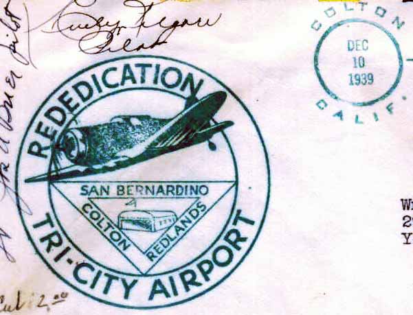
A postmark commemorated the 12/10/39 Rededication of Tri-City Airport (enhanced by Bill Grasha).
Tri City Airport, as depicted on the 1942 USGS topo map (courtesy of Kevin Walsh).
Tri-City Airport was depicted as a civil airfield on the 1944 LA Sectional Aeronautical Chart (courtesy of John Voss).
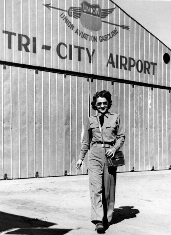
A circa WW2 photo of Tri-City Airport owner/operator Pinky Brier in her WASP uniform in front of a Tri-City hangar.
The 1947 LA Local Aeronautical Chart (courtesy of Tim Zukas) depicted Tri-City Airport as having a 2,900' unpaved runway.
Tri-City Airport, as depicted on a 1947 street map (courtesy of Kevin Walsh).
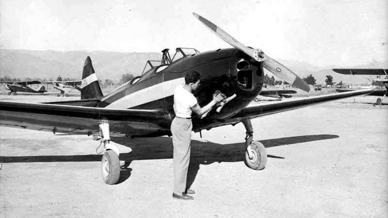
The only ground-level photo which has been located of an aircraft at Tri-City Airport
was a 1947 photo of August Santini polishing his Fairchild PT-19.
Bob Cannon recalled, "I used to fly a lot at night with the CA National Guard, mainly because I was still a student in school.
The only woman's voice one would hear would be that of 'Pinky' who ran Tri-City Airport. I would always say hello to her over the radio."
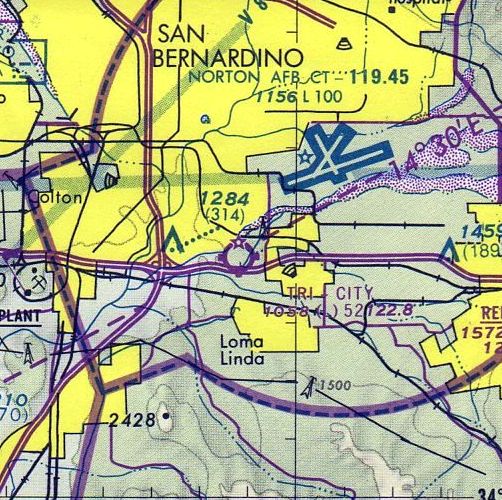
Tri-City Airport was located only 2 miles southeast of what was Norton AFB (now San Bernardino International Airport).
Reinhard Jarschke recalled of Tri-City, "I based there for awhile.
The runways were dirt, which was the biggest disadvantage to basing there.
Pinky told me they would pave the runways but the taxes were already killing them & paving would raise them further.
There was an instrument approach off the Colton (now Pettis) beacon,
or one could use the Norton ILS & break off to land at Tri City."
Richard continued, "It was in the control zone of Norton Air Force Base and that fact,
coupled with the snotty attitude of the air force & Pinky's aggressive & abrasive personality generated a lot of friction between the two.
An acquaintance landed an Air Force P-51 there by mistake & by the time he stopped rolling,
Pinky was on the wing cussing at him. When she got off the wing, he wheeled around & took off."
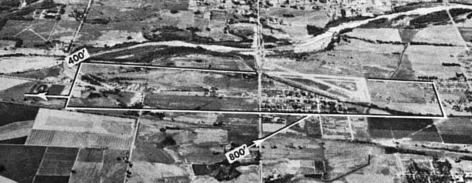
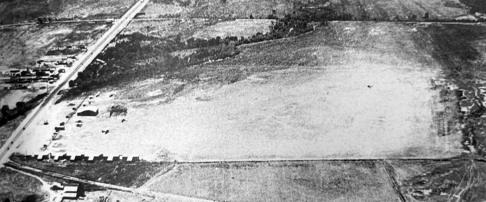
An undated aerial view looking north at Tri City Airport from the 1950 Air Photo Guide (courtesy of Kevin Walsh, enhanced by Bill Grasha).
It described Tri City Airport as having 3 dirt 3,000' runways, and listed the managers as Joseph & Evelyn Brier.
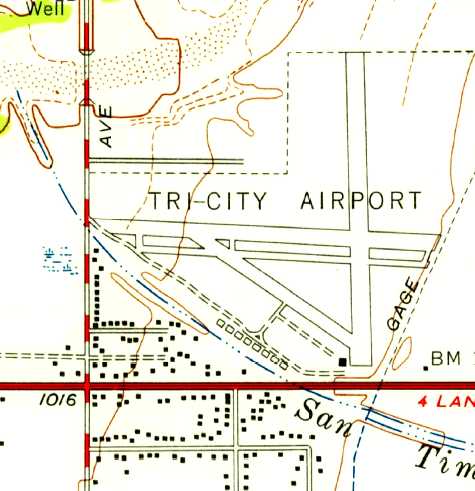
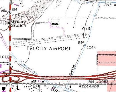
The 1954 USGS topo map depicted Tri-City as having 3 runways, and a row of hangars along the southwest side of the field.
The 1960 Jeppesen Airway Manual (courtesy of Chris Kennedy)
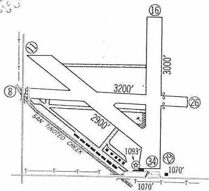
depicted Tri-City as having 3 unpaved runways (with the longest being the 3,200 Runway 8/26),
along with a row of hangars along the south side of the field.
The May 1961 LA Local Aeronautical Chart (courtesy of Ron Plante) depicted Tri City Airport as having a 3,200' unpaved runway.
A 1961 street map (courtesy of Frank Acosta) depicted Tri-City Airport as having 3 runways.
A 1961 aerial view of Tri-City Airport (courtesy of Bob Anderson, enhanced by Bill Grasha)
depicted the field as having 3 runways, taxiways, and a ramp on the south side.
Tri-City was listed among active airports in the 1962 AOPA Airport Directory,
with 2 unpaved runways (18/36: 3,000' & 13/31: 2,900'),
and the operators listed as Evelyn & Joseph Brier.
It was among airports served by Cable Commuter Airlines,
which operated De Havilland Twin Otters on routes from Los Angeles
to several small airports in the area (including Morrow Field & Brackett Field).
Len Savage recalled, “I grew up just blocks from Tri-City Airport; on Wallace Court off of San Bernardino Avenue & in 1966 at age 16 I started flying & soloed there.
I recall Pinky as being a tough boss. My instructor was a grumpy old WWII veteran.
There was then only Runway 7/25 with 25 being the active most of the time.
We would be out in an old straight-tail / no back window Cessna 150 over Yucaipa,
we'd 'home' on a commercial radio station, maybe KFXM or KMEN, and I'd gradually raise the volume to hear the music & he'd slap my hand & tell me to identify it & turn it down.
I recall the story of a C-130 once landed Tri-City & reversed propellers to stop & raised a giant dust cloud,
spun around & raised an even bigger dust cloud taking back off before entering the pattern at Norton AFB.”
Esther Miller recalled, "For 3 years from 1969-72, I lived on Tippecanoe Avenue in San Bernardino,
about 3 houses south of the east end of Pinky's east-west runway at Tri-City.
I knew nothing about aviation until I began dating my husband (a private pilot) in early 1971,
but I'd already learned enough to really whet my appetite for more."
"I listened to an FM broadcast station near the middle of the FM dial, and just off from its frequency,
I would often hear what I soon realized was Pinky returning to Tri-City.
Often I'd hear her call whatever controller was handling her flight:
'This is Pinky I (or else Pinky II) on approach for Norton, breaking it off for home.'
Sometimes I'd hear the controller before I'd hear her.
One night an older man's voice did a lovely imitation of W. C. Fields:
'Hello my little Chickadee' and soon she was close enough for me to hear both sides of the conversation.
Once I knew more about aviation & radio protocol,
I realized what a special place Pinky held in the aviation community of Southern California."
"I watched what to me was a miraculous take-off one day of a plane I came to respect.
The field was muddy & the Twin Otter reared up into the air in just a few feet from the start of the runway,
then slowly gained speed, a few feet above the muck.
Only later did I hear about soft field takeoffs."
Phil Du Bois recalled, "I landed several time at the Tri-Cities Airport in 1971-72.
'Pinky' was a bigger-than-life character then also.
Unbeknown to me, and apparently several of my pilot friends, the Tri-City airport had a landing fee.
Ignorance is bliss as we did touch & goes, one after another (no radios used much in those days).
I thought that the nice lady standing alongside the airport was encouraging us on as we practiced our landing.
Until she started throwing rocks at us. Never went back. That was in 1971, 72, maybe 73."
The runway configuration at Tri-City had drastically changed at some point between 1960-77,
as the 1977 Pilot's Guide to CA Airports (courtesy of Chris Kennedy)
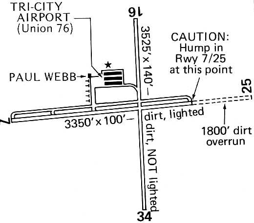
depicted the field as having 2 dirt runways: a 3,350' Runway 7/27 (with an 1,800' dirt overrun) and a 3,525' Runway 16/34.
A parallel taxiway ran along the north side of Runway 7/25, and a ramp northwest of the runway intersection had 3 hangars.
The operator was listed as Tri-City Airport, and Paul Webb offered flight instruction.
Michael Stewart recalled, “I rode with Pinky Brier weekly in 1977-78 as she transported 3 of us County inspectors to Needles during the construction of the Colorado River Bridge.
She was quite a character. She was flying an Beechcraft A36 & would take us to Needles on Monday mornings & bring us back on Friday afternoons.
Whoever was in the front seat got to fly the plane back. She showed us all kinds of sights in the desert.”
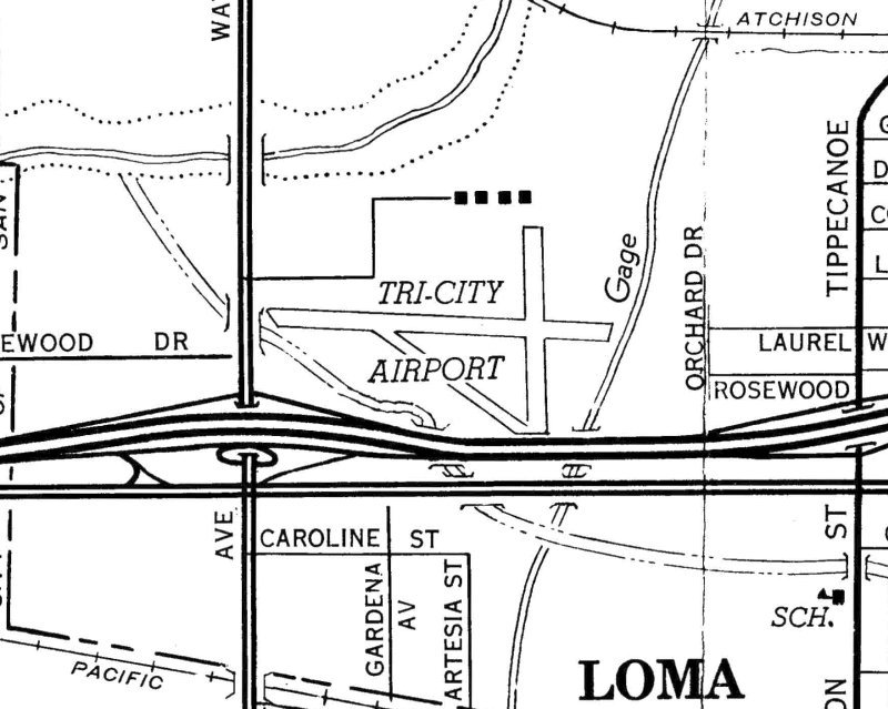
Tri-City's north/south runway was apparently abandoned between 1977-78, as the 1978 USGS topo map only depicted the east/west runway.
This was presumably due to the construction of the 10 Freeway, which was built along the southern end of the north/south runway.
According to Walt Ferar, “When the airport was closed / sold to Tri-City Corporate (1979),
I was told the agreement with Pinky was that some form of aviation had to stay on the property, hence the helipad.”
This helipad, known as R.I. San Bernardino G/L Helistop Heliport (74CA), was eventually built on East Carnegie Drive, just east of the fire station.
Walt reported, “The Tri-City helipad did get some use... students practiced there & Edison pilots used it.”
The 1980 USGS topo map depicted the total length of the east/west runway as 3,800', and also indicated that a 4th hangar had been added.
The last aeronautical chart depiction which has been located of Tri-City Airport
was on the August 1980 LA Terminal Aeronautical Chart (courtesy of Mitchell Hymowitz).
It depicted Tri-City Airport as having a 5,200' unpaved runway.
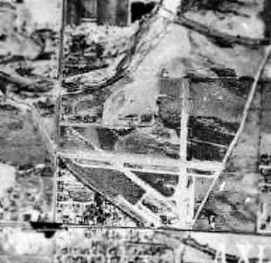
The last photo which has been located of the Tri-City Airport was a 1980 aerial view (enhanced by Bill Grasha).
It appeared as if the airport had already closed at this point, as there was not a single aircraft visible on the field.
Tri-City Airport was reportedly closed in 1983.
According to Reinhard Jarschke, "The airport was originally sold to some electronics company who paved & upgraded the field, but never [re]opened it.
After being unused for a few years it was subdivided for businesses."
A 1994 aerial view showed the Tri City Airport property to be redeveloped,
but a small aviation use of the property continued, as the R.I. San Bernardino G/L Helistop Heliport (74CA) had been built on East Carnegie Drive, just east of the fire station.
According her niece Victoria Pinckert Rafa, former Tri-City Airport owner Evelyn (Pinky) Brier lived in a house on the airport site,
built after the airport property was sold to developers.
"The building is large enough to house many of the things from the airport,
including a plane & Jeep used to transport people to & from their airplanes."
Ferar continued, “Pinky lived in one of the warehouses in the corporate center until her death [2008].
There is a street, East Brier Drive, named after her in the complex.”
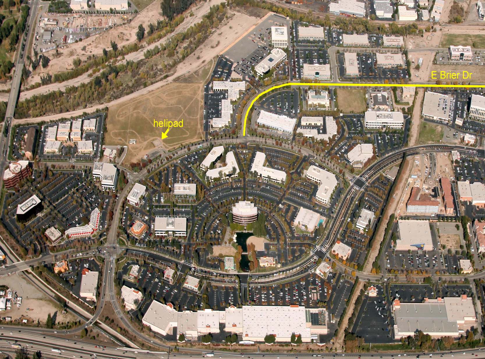
A 2013 aerial view by Walt Ferar looking north at the Tri-City Airport site, annotated by Walt to show the helipad & East Brier Drive.
According to Walt Ferar, the R.I. San Bernardino G/L Helistop Heliport built on the Tri-City Airport site was closed to landings in about 2014.
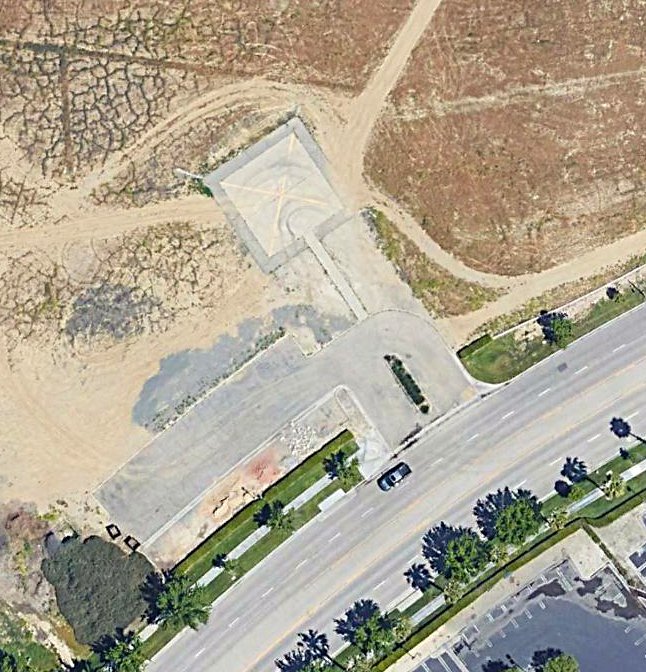
A 2019 aerial view of the last aviation facility at the site of Tri-City Airport: the R.I. San Bernardino G/L Helistop Heliport,
which has been marked closed with a yellow “X” symbol.
The site of Tri City Airport is located northeast of the intersection of Interstate 10 & South Waterman Avenue.
____________________________________________________
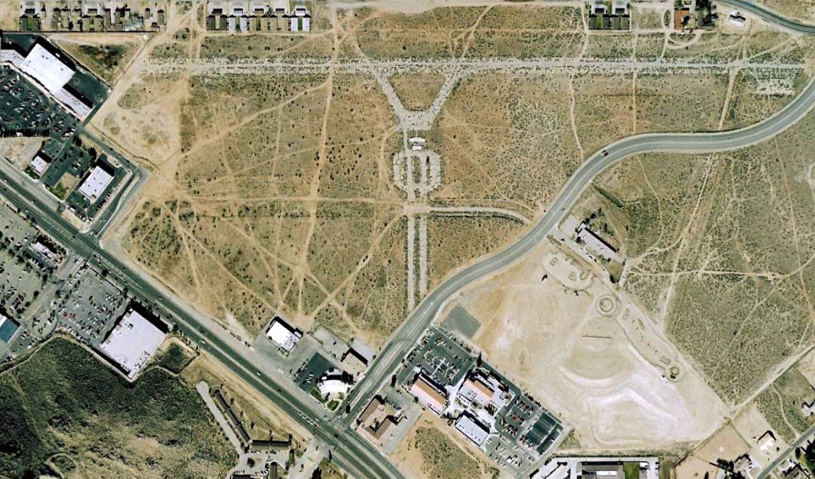
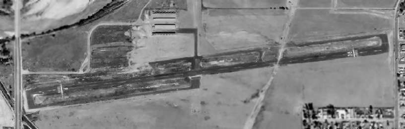
Morrow Field (RTO), Rialto, CA
34.08, -117.36 (East of Los Angeles, CA)

Morrow Field, as depicted on the August 1946 LA Sectional Chart.
Entrepreneur Howard Morrow opened Morrow Aircraft in Van Nuys in 1940.
He designed the Morrow Trainer, an all-wood monoplane trainer intended for military use,
and produced a single prototype in 1941.
Morrow Field was reportedly built in 1942, after the military purchased Morrow's original airfield facilities (later to become Norton AAF).
The Morrow company was unsuccessful in obtaining any military orders for their aircraft,
but did produce drop tanks & other aircraft components during WW2.
The sole prototype of the Morrow Trainer went into storage.
Morrow Field may have gone through a period of inactivity during WW2,
as it was not depicted on the February 1944 LA Sectional Chart or the August 1945 LA Sectional Chart
nor listed in the 1945 AAF Airfield Directory (courtesy of Scott Murdock).
The earliest depiction which has been located of Morrow Field was on the August 1946 LA Sectional Chart.
It depicted Morrow Field as a commercial/municipal airport.
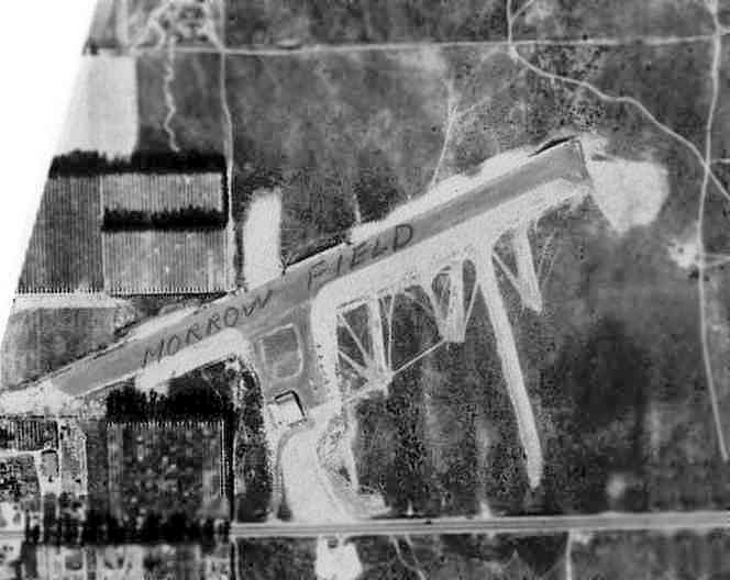
The earliest photo which has been located of Morrow Field was a November 1946 aerial view (courtesy of Bob Anderson, enhanced by Bill Grasha).
It depicted Morrow Field as having a single northeast/southwest runway, with a ramp & a single hangar on the south side of the field.
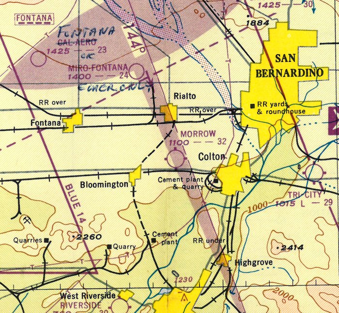
The 1947 LA Local Aeronautical Chart (courtesy of Tim Zukas) depicted Morrow Field as having a 3,200' unaved runway.
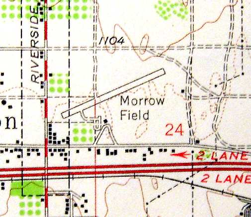
The 1954 USGS topo map (courtesy of Scott O'Donnell) depicted Morrow Field as having a single 3,200' northeast/southwest runway,
and a taxiway leading to a single hangar along the south side of the field.
The 1955 San Diego Sectional Chart (courtesy of John Voss) described Morrow as having a 3,200' paved runway.
Bob Cannon recalled, "My uncle lived adjacent to Morrow Field,
in fact some of the land may have been originally his. I used to fly in to visit them."
The runway at Morrow Field was also used for drag racing.
According to Paul Baechler, "Colton Raceway at Morrow Field (the dragstrip) was active in the 1950s & 60s, according to racing websites.
Apparently the airport was closed during races & the runway used."
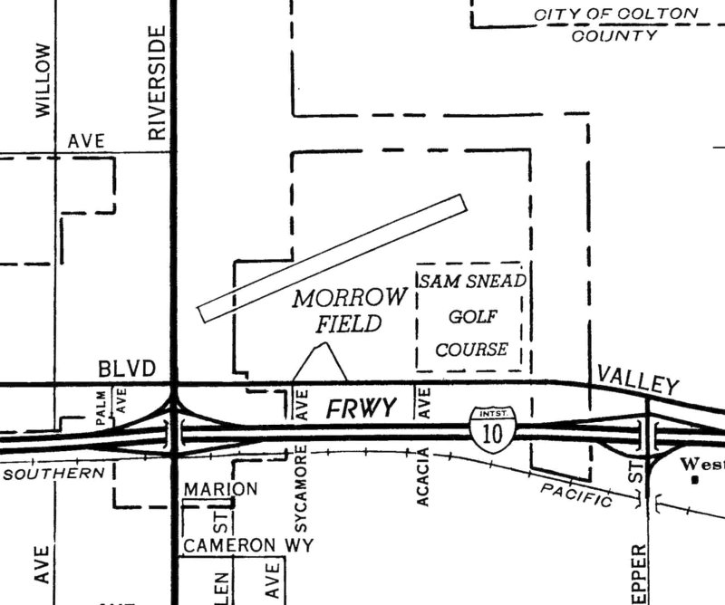
A 1961 street map (courtesy of Frank Acosta) depicted Morrow Field as having a northeast/southwest runway.
The May 1961 LA Local Aeronautical Chart (courtesy of Ron Plante) depicted Morrow Field as having a 3,200' paved runway.
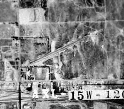
A 1961 aerial view of Morrow Field (courtesy of Bob Anderson, enhanced by Bill Grasha)
showed the field in largely the same configuration as it had appeared in the 1946 photo.
Morrow Field was listed among active airports in the 1962 AOPA Airport Directory,
with a single asphalt 3,360' Runway 9/27, and the operator listed as Howard Morrow.
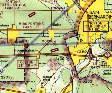
The 1965 LA Local Aeronautical Chart depicted Morrow Field as having a single 3,000' northeast/southwest paved runway.
According to John Suchil, “Morrow Airport... San Bernardino Valley College maintained classes there in the 1960s.
They had an Airframe & Hydraulics class there.
SBVC had a Beech 18 (war surplus) that we completely stripped down to the metal.
Art Scholl was the head of the Aeronautics department at the time & supervised the operation.
The Beech was also used for the Navigation Flight Lab class that Art taught.
The day of my first class at Morrow Field Art was giving rides to class members that had helped him restore a Stearman.
I remember seeing & being told that the damaged Beech 18 cowlings there came from the plane used for the movie Mad, Mad, Mad, Mad, World.
We once attended an inter-colligente air meet in Hollister, CA.
The night before the trip I had to work at night & didn't want to miss the early flight the next morning.
Art let me sleep in the Beech that night at Morrow Field.
I used a sleeping bag but it was uncomfortable due to the tilt of the flight deck.
I can't remember if he left the plane unlocked or gave me a key for entry.”
According to the San Bernardino County Sun, at an unknown date Howard Morrow Sr. built a golf course adjacent to the airfield,
a social club with a swimming pool, and even a short-lived shallow lake on which water skiers were pulled with a cable.
Morrow sold the airport in 1968.
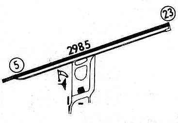
Morrow Field, as depicted in the 1968 Flight Guide (courtesy of Chris Kennedy).
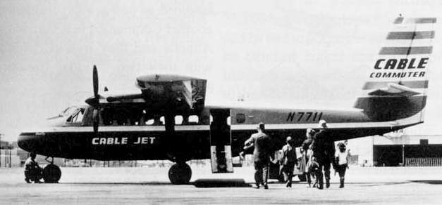
An undated photo of a De Havilland DHC-6 Twin Otter operated by Cable Commuter Airlines.
Cable Commuter Airlines began operations in 1968 & operated passenger airline service into Morrow Field.
They eventually operated 12 De Havilland Twin Otters on routes from Los Angeles
to a number of small airports in the area (including Tri-City Airport & Brackett Field).
Sometime later the airline was bought out by a larger company, which soon went out of business.
Phil Du Bois recalled, "I visited the 'Colton' Airport in 1971 several times,
as my instructor took me there for landing practice because it was a 'tight' airport.
That is there were telephone poles at either end. It was obvious then that the airport was on it's way out.
I do not remember the airport existing after 1972."
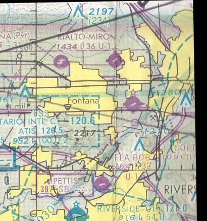
The last aeronautical chart depiction which has been located of Colton-Morrow Airpark was on the January 1976 LA Sectional Chart.
However, "Colton Airpark: Morrow Field" was listed in the 1977 Pilot's Guide to CA Airports (according to Chris Kennedy),
and was described as having a single 2,985' paved Runway 5/23.
Morrow Field evidently was closed at some point between 1977-79,
as it was depicted as an abandoned airfield on the the January 1979 LA Sectional Chart (courtesy of Mitchell Hymowitz).
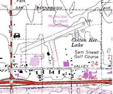
The 1980 USGS topo map depicted "Municipal Airport (Abandoned)" as having a ramp extending south from the midpoint of the runway,
with several small buildings (hangars?) on either side of the ramp.
A 1980 aerial view showed a Price Club had been built on the southeast corner of the Morrow Airport site.
The runway still remained intact, but the hangar had been removed.
The Price Club on the Morrow Airport site was closed in the mid-1990s.
According to the San Bernardino County Sun, the former Price Club building was reused by a food processing company.
A 1995 aerial view showed no trace remaining of Morrow Field's runway.
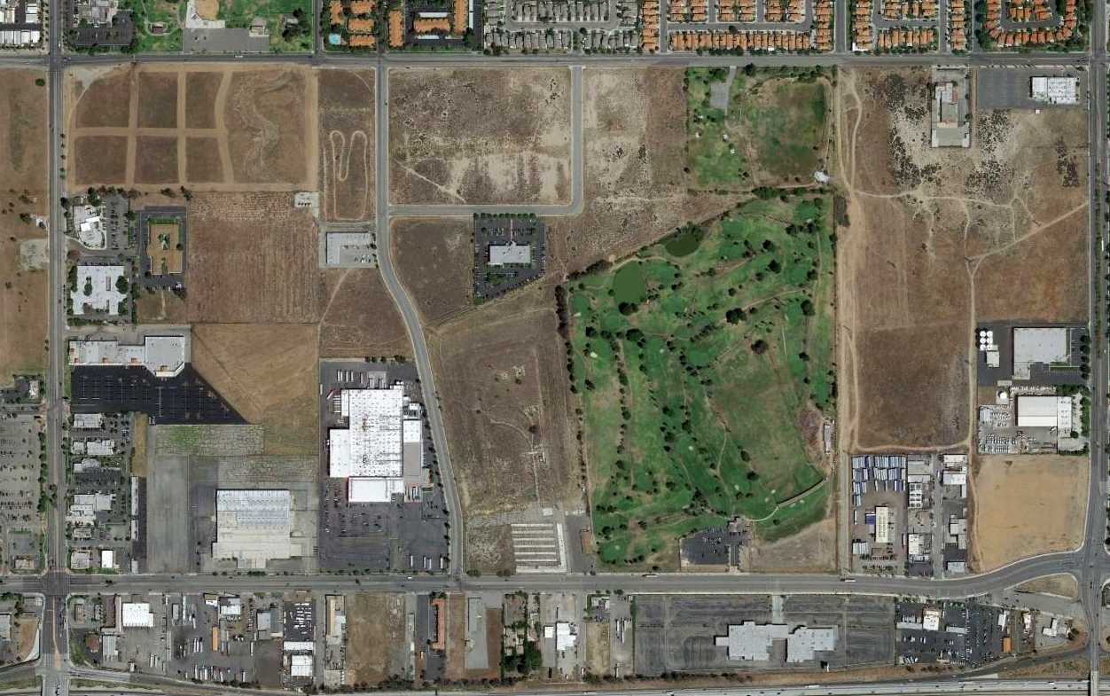
A 2014 aerial view showed Wildrose Avenue had been built through the middle of the site of Morrow Field..
The golf course built by airport founder Howard Morrow Sr. still exists on the southeast portion of the former airport property, now known as Sam Snead Golf Course.
The diagonal orientation of the former runway is still apparent.
The site of Morrow Field is located northeast of the intersection of South Riverside Avenue & West Valley Boulevard.
____________________________________________________
____________________________________________________
This site covers airfields in all 50 states.
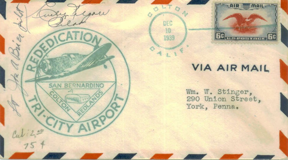