
Abandoned & Little-Known Airfields:
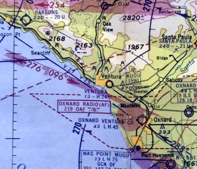
California: Ventura area
© 2002, © 2026 by Paul Freeman. Revised 2/24/26.
This site covers airfields in all 50 states: Click here for the site's main menu.
For a 10th year, the CA pages of this website are sponsored by the California Pilots Association:
____________________________________________________
Please consider a financial contribution to support the continued growth & operation of this site.
Conejo Valley Airport (revised 2/24/26) - Henderson Field (revised 2/24/26) - Rancho Conejo Airport (revised 9/19/19)
(Original) Santa Barbara Airport / Carpinteria Airport (revised 2/24/26 - Santa Susana Airport (revised 9/5/23) - Ventura Airpark (revised 6/19/20)
____________________________________________________
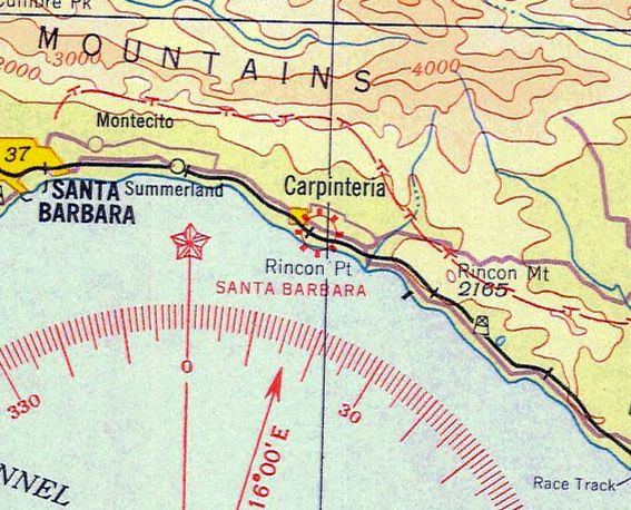
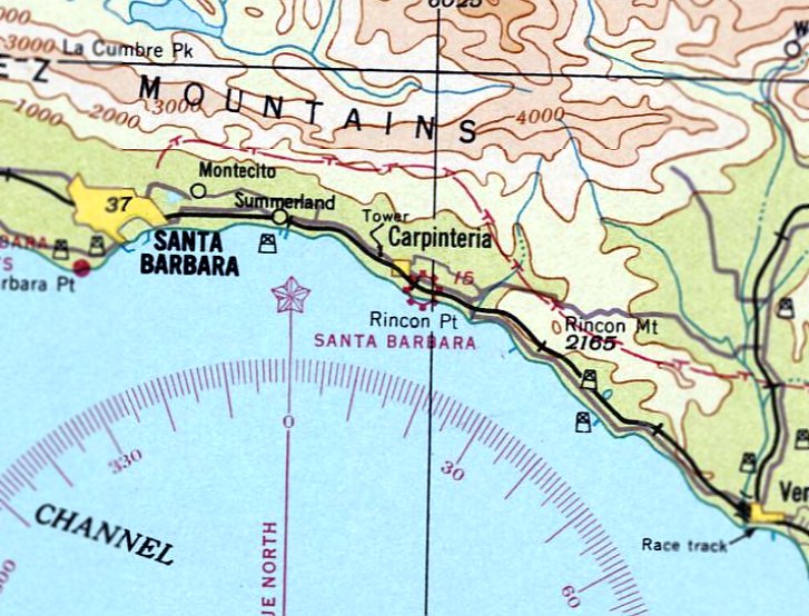
(Original) Santa Barbara Airport / Carpinteria Airport, Carpinteria, CA
34.391, -119.508 (Northwest of Los Angeles, CA)
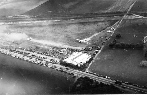
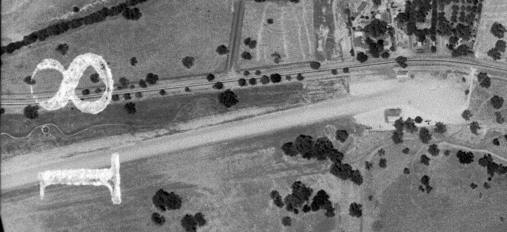
A circa 1929 aerial view looking southeast at Carpinteria Airport (courtesy of Charles Stuart).
According to the text of a historic sign on the site of Carpinteria Airport photographed in 2016 by Charles Ctuart,
“On this land owned by the Catlin, Franklin, and Higgins families,
an airport established by Jack Chadbourne & Bob Donze became the largest on the South Coast, operating from 1928-35.
Among notables who landed here were Wiley Post, Howard Hughes, Will Rogers, and Charles Lindbergh.”
The earliest photo which has been located of Carpinteria Airport was a circa 1929 aerial view (courtesy of Charles Stuart).
It depicted an arch-roof hangar on the corner of a grass airfield, with a large crowd of spectators in attendance,
and at least 8 biplanes on the field.
The earliest aeronautical chart depiction which has been located of the airport in Carpinteria was on the 1932 LA Sectional Chart.
It depicted “Santa Barbara” as a commercial/municipal airport.
According to the text of a historic sign on the site of Carpinteria Airport (photographed in 2016 by Charles Stuart), Carpinteria Airport operated until 1935.
It had been replaced by the larger Santa Barbara Municipal Airport located several miles west.
The last depiction which has been located of the Santa Barbara Airport in Carpinteria was on the March 1937 LA Sectional Chart.
The Santa Barbara Airport in Carpinteria was no longer depicted on the January 1938 LA Sectional Chart.
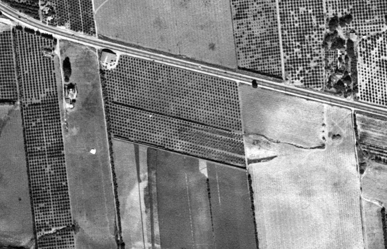
An 11/3/45 aerial view (from the UCSB Library) showed the arch-roof former Carpinteria Airport hangar remaining, but the airfield was no longer recognizable,
with the land having been returned to cultivation.
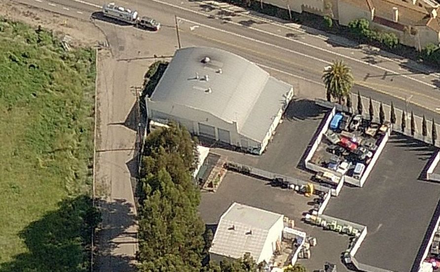
A circa 2010-2015 aerial view looking north at the former Carpinteria Airport hangar.
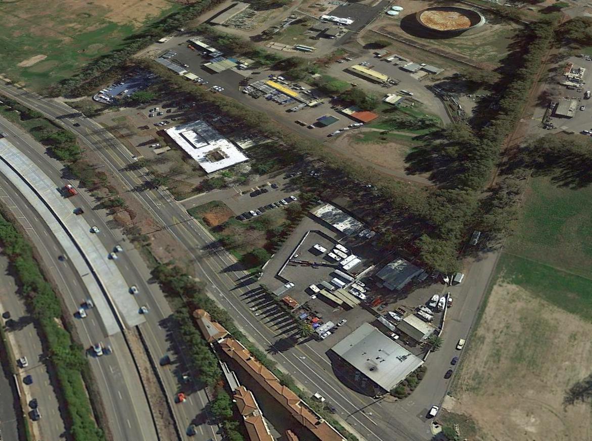
A 2016 aerial view looking southwest at the site of Carpinteria Airport, with the former hangar in the foreground.
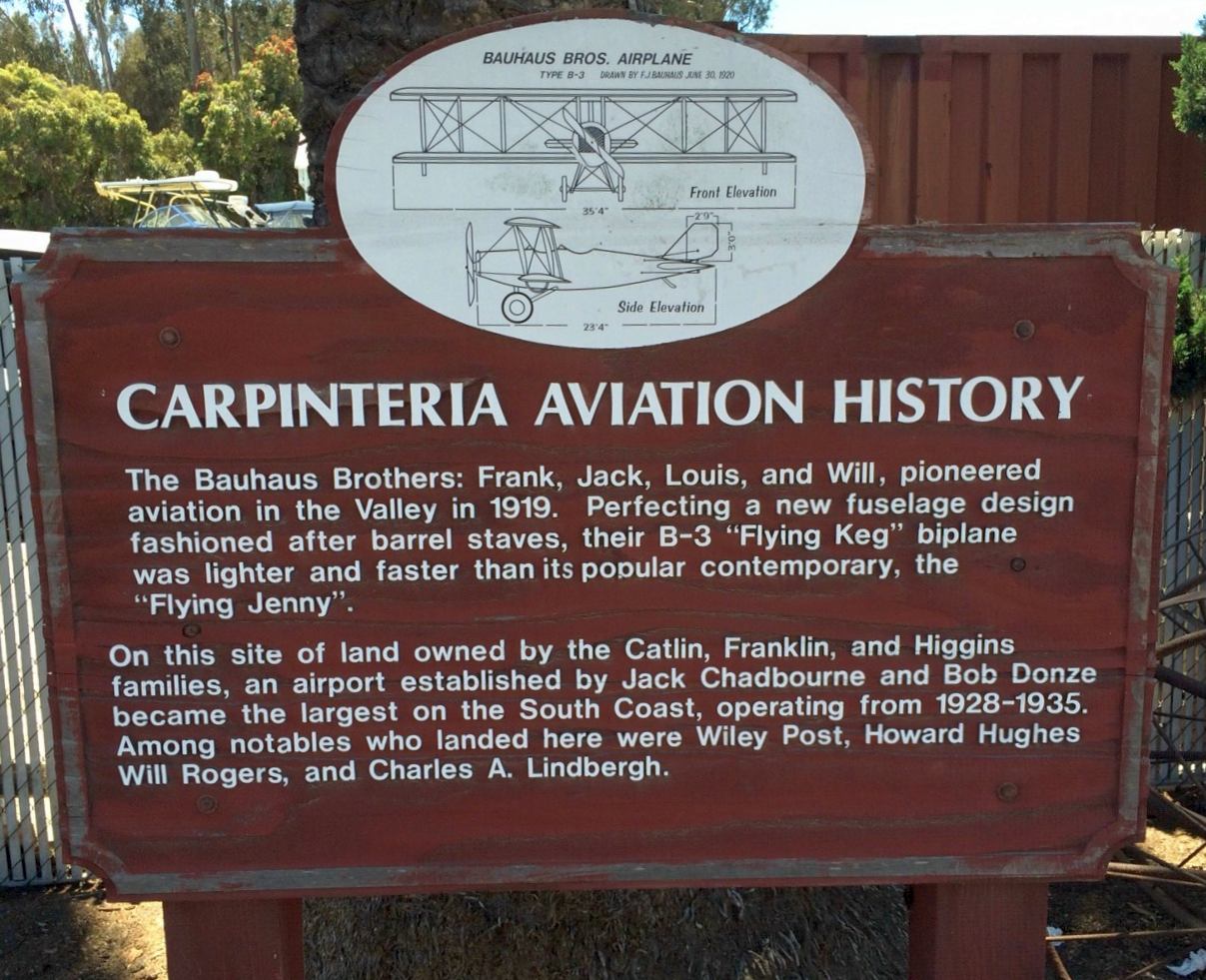
A 2016 photo by Charles Stuart of the historic sign on the site of Carpinteria Airport.
Charles reported, “I was visiting in Carpinteria & noticed a historic marker sign about a former airport on the site.
It was sometimes called Carpinteria Airport & sometimes Chadbourne-Bonz Airport.”
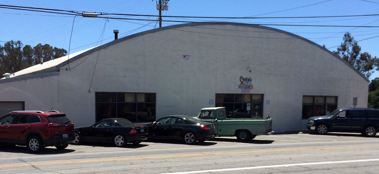
A 2016 photo by Charles Stuart looking south at the former Carpinteria Airport hangar, reused as Costas Auto Works.
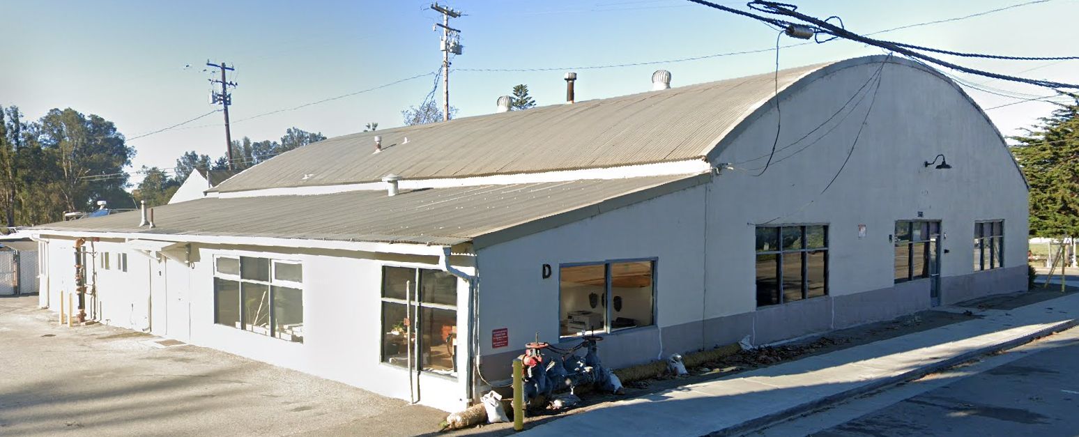
A 2025 photo looking southwest at the former Carpinteria Airport hangar.
The site of Carpinteria Airport is located southeast of the intersection of Carpinteria Avenue & Dump Road.
Thanks to Charles Stuart for pointing out this airfield.
____________________________________________________
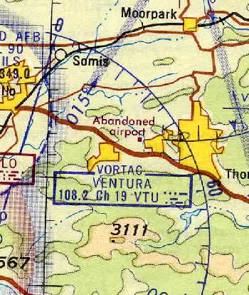
Santa Susana Airport, Simi Valley, CA
34.27, -118.71 (Northwest of Los Angeles, CA)
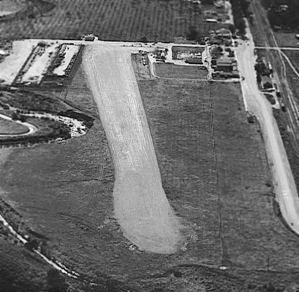
The earliest photo which has been located of Santa Susana Airport was a 1940 aerial view by looking southeast (courtesy of Jeffrey Niven).
According to Joe Hitch, “The Santa Susana Airport first became a reality in 1938 when Byron (Pop) Dwelle moved to Santa Susan Knolls.
The land for the airport was a part of Marrland Properties, old timers will remember the Marrland Country Club,
and was bought by Pop Dwelle for the express purpose of building an airport.
Pop owned several airplanes & he wanted a place close to his home to keep his airplanes & to fly from.
Pop was responsible for a number of young boys, like Bob Crowell & myself, starting a career in aviation.”
Santa Susana Airport was not yet depicted on a 1939 aerial photo (courtesy of Tom McKerr), which instead showed an empty field.
The earliest photo which has been located of Santa Susana Airport
was a 1940 aerial view by looking southeast (courtesy of Jeffrey Niven).
It depicted the field as having a single unpaved east/west runway,
with a small building & a few light planes parked along the northwest side of the field.
According to Joe Hitch, “During WWll Pop Dwelle [Santa Susana Airport] joined the United States Army Air Corp Ferry Command
and in 1943 or 1944 was killed flying a Lockheed P-38 while ferrying to North Carolina.
Shortly after his death his widow, Gladys sold the property.”
Santa Susana Airport was not depicted on the February 1944 LA Sectional Chart.
According to Drennen vs. County of Ventura (courtesy of Iris Smoot), the land of the Santa Susana Airport was owned by Chester Foster since 1944.
The Foster family operated it as a public airport for small private planes.
According to the book “Simi Valley: A Journey Through Time”,
“A small private landing strip near the southerly end of Tapo Street was converted into Santa Susana Airport in the mid-1940s by Chester 'Chet' Foster.”
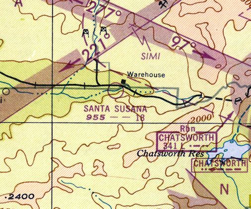
The earliest aeronautical chart depiction of Santa Susana Airport which has been located was on the March 1945 LA Sectional Chart,
which depicted Santa Susana as a commercial/municipal airport.
A 10/24/45 aerial view (from the UCSB Library) depicted Santa Susana Airport as having a single unpaved northeast/southwest runway,
with 8 light aircraft parked near some small buildings on the northwest side.
The 1947 LA Local Aeronautical Chart (courtesy of Tim Zukas)
depicted Santa Susana as having a mere 1,800' unpaved runway.
The Santa Susana Airport was not yet depicted on the 1948 USGS topo map.
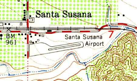
The 1951 USGS topo map depicted Santa Susana Airport as having a single northeast/southwest runway,
with a parallel taxiway leading to a ramp with several buildings on the northwest side.
The September 1954 USAF LA Sectional Chart (courtesy of Chris Kennedy)
described Santa Susana Airport as having an 1,800' unpaved runway.
Bill Appleton recalled, “Another part of the story was the frequent filming of the Whirlybird [TV] series
at the airport over a 3-year period in the mid-1950s.
My dad had 2 planes (Piper Cub & Tri-Pacer) at Santa Susana from 1958 until the day it closed.
He ran a radio & TV repair shop a block away from 1946-85 & worked on some of the guys' radios.
He would leave work at lunchtime, walk to his plane & fly over to Santa Paula to eat lunch & fly back.
His Tri-Pacer was the last plane to leave the field, or so he used to say.
My uncle was also an instructor there for a while.
The Mexican restaurant at the end of the strip on south Tapo Street (and slightly north by about 100 feet)
was called El Gallito & it was owned by Norm Havins.”
Glenn Diefenderfer recalled, “Simi Valley... I lived there from 1956-70 & had my first airplane ride there in Bill Appleton's Cub at the age of 9.
I remember flying at night having to use car headlights to light up both ends of the runway for night landings.
That was long before they cut the 'notch' in the hill at the East end of the airport to eliminate the dicey approaches.
I also remember watching them film the TV show Whirlybirds.”
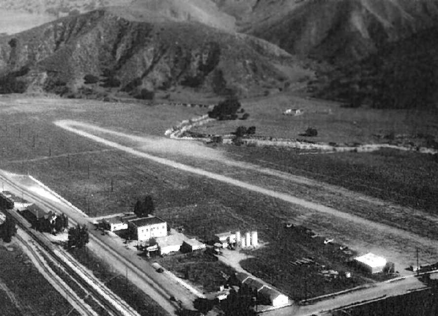
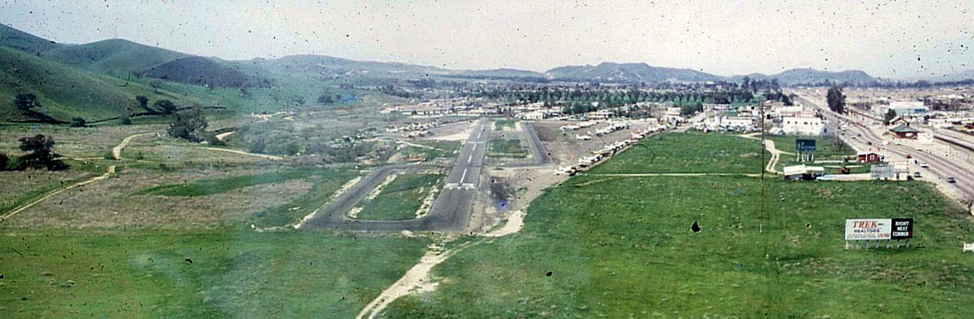
A 1959 aerial view looking west at Santa Susana Airport by Mel Aldrich (courtesy of Bill Appleton & the Simi Valley Historical Society & Museum).
The photo depicted the field as having a single east/west dirt runway, and several light planes were visible at the northwest end of the strip.
Santa Susana Airport was listed among active airports in the 1962 AOPA Airport Directory,
with a 1,900' bare Runway 9/27, and the operator listed as Chester Foster.
According to Bill Appleton, Joe Pfeifer “operated the airport for a while after the Fosters sold it.”
Santa Susana Airport, as depicted on the August 1964 LA Local Aeronautical Chart (courtesy of Donald Felton).
A 1964 aerial view (courtesy of Tom McKerr) depicted Santa Susana as having a single unpaved east/west runway with a parallel taxiway,
with a dozen light aircraft on the northwest side.
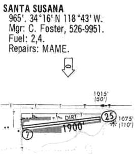
Santa Susana Airport was still described in a 1968 airport directory (courtesy of Glenn Beltz) as having a 1,900' dirt runway.
The county took over the Santa Susana Airport on 1/1/69, and subsequently paved the runway, according to Drennen vs. County of Ventura (courtesy of Iris Smoot).
Jeff Fischer recalled, “Santa Susana Airport... My 1st flying experience happened there in 1969 at the age of 8 when one of my fellow Cub Scout’s dad took us up 2 at a time.”
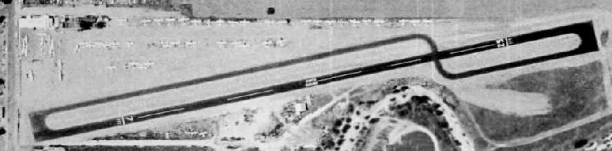
A 1969 aerial view showed Santa Susana Airport's newly paved runway & parallel taxiway.
The airport was quite healthy, with over 60 light aircraft visible on the field.
As depicted on the 1969 USGS topo map, Santa Susana Airport consisted of a single 1,900' runway, a parallel taxiway,
and several small buildings northwest of the runway.
A 9/30/70 aerial view (courtesy of Jim McCleary) looking west from final approach to Santa Susana Airport's Runway 25.
Jim McCleary recalled, “I rented Cessna 150 N51167 at the local flying service Hughes Aviation (cost was $14 for 0.9 hour).
I was taking my new girlfriend for a ride, and she grabbed my camera & took the photo on final [approach].”
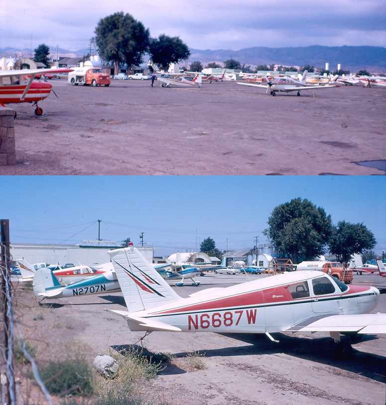
A 1972 photo by Jeff Niven of the large number of general aviation aircraft on the ramp at Santa Susana Airport.
Jeff Niven recalled, “To land on the runway coming from the east
required that the pilot make a very difficult maneuver around a hill.
Upon taking off, the planes passed over a city street as less than 100' above the ground (under good conditions).
There was a sign on the street which warned car traffic of 'Low Flying Aircraft'.”
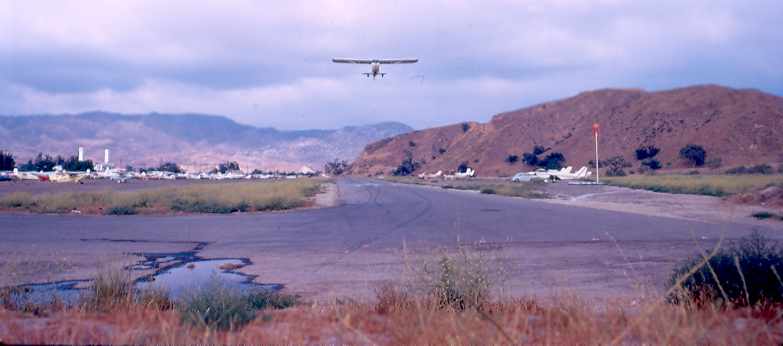
A 1972 photo by Jeff Niven looking east at a single-engine aircraft taking off from Santa Susana Airport's Runway 25.
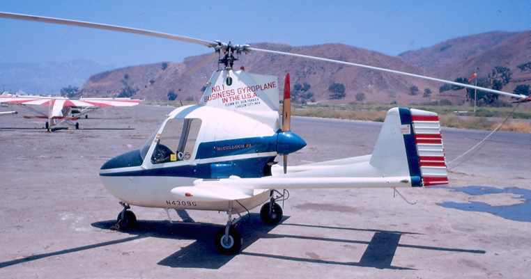
A 1972 photo by Jeff Niven of a McCullough J2 Gyrocopter on the ramp at Santa Susana Airport.
Mark Robinson recalled, "During the summer of 1972 I went to a fun airshow [at Santa Susana Airport] in Simi Valley
where Clay Lacey's P-51 'Snoopy' was one of the featured acts.
Clay had somehow managed to shoehorn the Mustang into that short field the night before."
"Taking off the next day, Clay & his Mustang put on the most dramatic takeoff & beat-up I've ever seen.
After a careful run-up on the east end of Santa Susana,
Clay screamed down the runway past the crowd & got the Mustang off quite literally over the fence,
after using almost all the runway (with the mains planted on until almost the very end)."
"Just minutes after he departed we were alerted to the fact by the airshow announcer
that Clay & 'Snoopy' were inbound from the west with over 500 mph on the clock (!)."
"Sure enough, out of the late afternoon haze you saw what appeared to be a razor's edge
coming at you on the deck in a shallow dive.
In a heartbeat he was zooming past us hugging the runway
and up over the Santa Susana pass in less time than it takes to talk about it."
"He was going so fast that when he went by, for a split second,
you did not hear the airplane as it was actually ahead of the sound pressure wave -
which came blasting on in behind him in short order."
"Clay did not land back at Santa Susana after performing his aerobatic routine
but instead went on home to Van Nuys.
I'll never forget those sights & sounds experienced at Santa Susana that day."
A circa 1970s aerial view looking south at Santa Susana Airport by Roger Freidman.
Roger Friedman recalled, “My mom was the airport manager / FBO from 1970-76.
I clearly remember the day Clay Lacey brought his P-51 to the airport (though I was 4 years old at the time).
I was there when Shazam was being filmed at the airport (also Ironside, and Spencer’s Pilots).
I remember meeting the whole cast. I was probably 8 years old.”
A circa 1970s photo by Roger Friedman of several Cessnas at Santa Susana Airport.
Bill Putney recalled in the early 1970s, "Santa Suzanna was a frequent destination since my instructor like to challenge me.
Crabbing in between the hill & the chemical plant storage tank at the end of the runway was a new trick as a fresh pilot."
William Appleton recalled, “I have a brief article with pictures from the 7/21/74 local paper
that covers the remarking of the runway to say '"Landing PPO' (Landing, Prior Permission Only).”
A still of a busy Santa Susana Airport from the 1975 episode "The Odd Couple” of the TV series “Shazam” (courtesy of Bill Bazen).
A aeries of stills of Santa Susana Airport from the 1976 episode "Ripcord” of the TV series “Shazam” (courtesy of Bill Bazen).
Santa Susana Airport was described in the 1977 Pilot's Guide to CA Airports (according to Chris Kennedy)
as having a single 1,880' paved Runway 7/25, but with displaced thresholds giving a landing distance of only 1,590'.
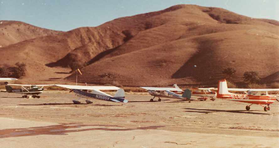
A 1977 aerial view showed several dozen light planes parked on Santa Susana Airport.
Pete Mason recalled, “Santa Susana Airport... My last time there was 1979
with Steve McQueen in his yellow Stearman doing takeoffs & landings,
taxiing back with the lower wings brushing through mustard plants
and then taking a break & eating at a Mexican restaurant just off the west end of the airport.”
The last aeronautical chart depiction which has been located of the Santa Susana Airport was on the July 1980 LA Terminal Chart (courtesy of Jim Hackman),
which depicted Santa Susana as having a 2,000' paved runway.

The last photo which has been located of the Santa Susana Airport was a 1980 aerial view.
The field still appeared fairly well-used, with a total of 25 light aircraft visible parked outside,
but that total was noticeably smaller than the number of planes visible on the field only 3 years previously.
The 1981 USGS topo map still depicted Santa Susana Airport.
Santa Susana Airport was apparently closed at some point between 1980-86,
as it was no longer depicted on the January 1986 LA Sectional Chart.
A 1989 aerial view (courtesy of Tom McKerr) showed the Santa Susana Airport property had been redeveloped,
with multiple buildings covering the airport site.
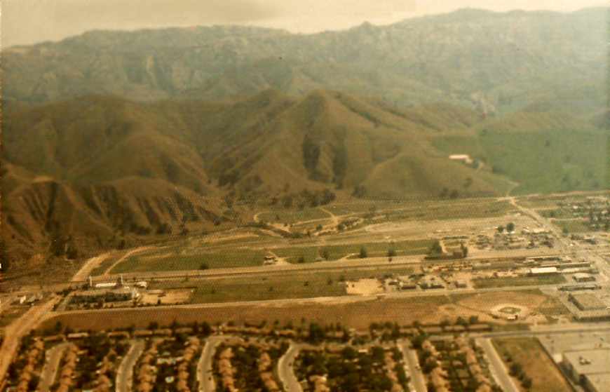
A 2006 photo by Jeff Niven looking southeast along Tapo Street at the site of Santa Susana Airport.
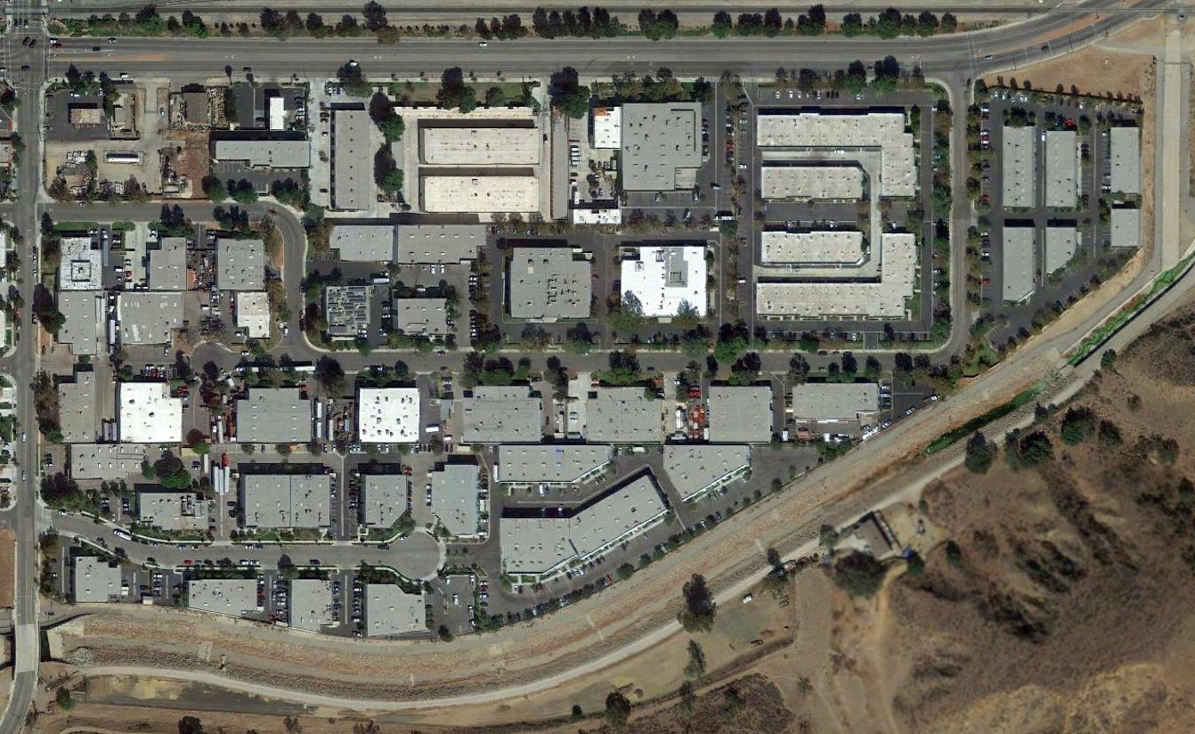
A 2016 aerial view shows no trace remaining of Santa Susana Airport.
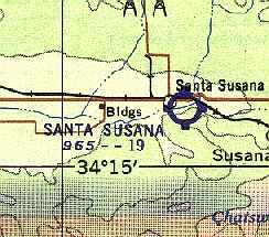
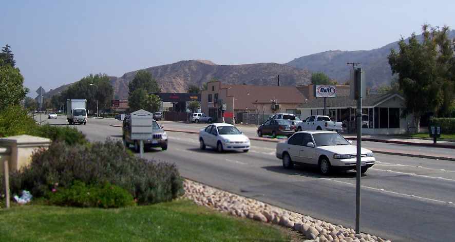
Santa Susana Airport was located southeast of the intersection of Los Angeles Avenue & Tapo Street.
The only clue to its former role is the name of the road running through the center of the property: Runway Street.
Thanks to Glenn Beltz for pointing out this airfield.
____________________________________________________
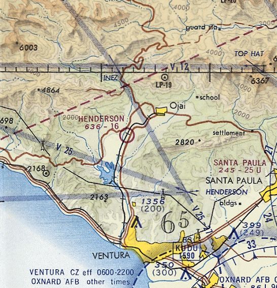
34.427, -119.29 (Northwest of Los Angeles, CA)
Henderson Field was depicted as an auxiliary airfield on the 1945 AAF Aeronautical Chart.
Henderson Field was not yet depicted on the 1941 USGS topo map.
According to a book by Pat Fry (courtesy of Pat Doerner via Hank Morris):
“In the early 1940s, Don Henderson built an airstrip on family property in Mira Monte to facilitate his passion for flying.
During World War II, the Army Air Corps commissioned him to run a small flying school there.”
Henderson Field was not yet depicted on the 1944 or 1945 LA Sectional Charts (courtesy of John Voss).
The earliest depiction which has been located of Henderson Field was on the 1945 AAF Aeronautical Chart.,
which depicted Henderson as an auxiliary airfield.
Pierce Stewart recalled, “My cousin, Don Henderson built & owned the airport in Ojai.”
According to a book by Pat Fry (courtesy of Pat Doerner via Hank Morris):
“In January, 1945, the airstrip went public & the following July, 37 year old Henderson died after crashing his plane near the airfield.
Venturan, Kendall Barr, subsequently took over the operation of Henderson Field.
The 2,100' x 50' runway accommodated about 20 small planes per week in those days.”
The 1946 LA Sectional Chart depicted Henderson as a commercial/municipal airport.
Henderson Field, as depicted on the 1947 USGS topo map.
The earliest photo which has been located showing Henderson Field in use was an 8/21/47 USGS aerial view.
It depicted Henderson as having a short unpaved northeast/southwest runway, with possibly a few light aircraft parked along the east side.
According to a book by Pat Fry (courtesy of Pat Doerner via Hank Morris), “In 1949, they built 6 hangars & a waiting room with restrooms.”
According to www.aerofiles.com, as of 1950 Henderson Field had a 2,100' runway.
According to Jeffrey Rountree, “The Ojai field catered to the well-to-do weekenders from L.A.”
Jim Cary recalled of Ojai, “An old timer told me how he would sometimes fly home at night
and have his wife go to the end of the runway & shine her car lights down the runway so he could find it.”
The most detailed depiction which has been located of Henderson Field was on the 1952 USGS topo map,
which depicted Henderson as having a single northeast/southwest runway, with a small building on the northwest side.
Bob Cannon recalled, “Henderson... I landed there in my 7AC in 1955. I recall landing in weeds.”
The 1956 LA Local Aeronautical Chart (courtesy of Tim Zukas) depicted Henderson as having an 1,800' unpaved runway.
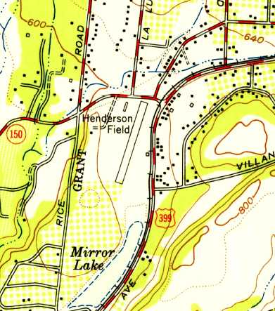
Henderson Field, as depicted on a 1960 street map (courtesy of Kevin Walsh).
Charles Davis recalled, “The runway was almost on Don Antonio Way in the Ojai Villa Mobile Estates
with a few T-hangars next to the railroad tracks (now a bike trail). It was a paved north/south runway.
I spent many hours watching the few aircraft flying patterns at the airport.
They also used the airport for skydiving at Lake Casitas when the water level was low in the mid-1960s.”
The 1964 Sectional Chart depicted Henderson as having a single 1,600' paved northeast/southwest runway.
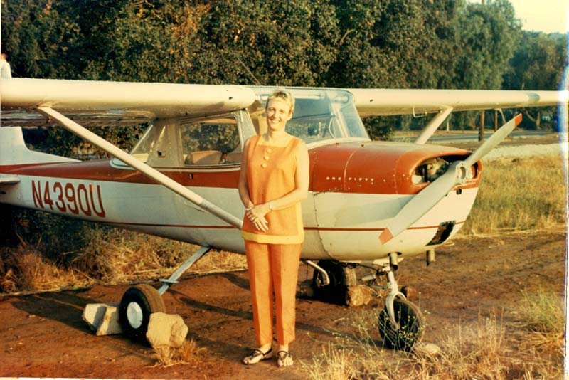
A circa 1965 photo by Bob Cannon of his Cessna 150D at Henderson Field. Bob recalled, “We walked across the street & stayed at a motel.”

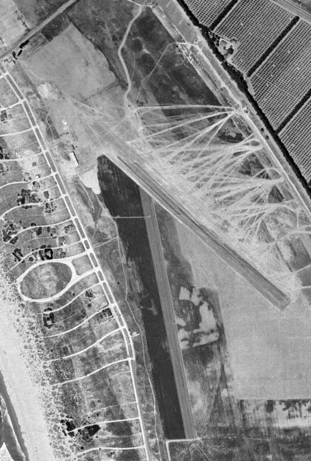
The last photo which has been located of Henderson Field was an 8/167 USGS aerial view.
It depicted Henderson as having an unpaved north/south runway, with a dozen light single-engine planes parked near some small hangars on the northwest & northeast sides.
Pierce Stewart recalled, “The runway was 1,900' long with eucalyptus trees at the south end. I flew in there several times in the late 1960s in my Tri-Pacer.”
Richard Arabian recalled, “Henderson Field... my logbook shows a landing there 4/28/68 in a Cessna 140 (N279W) while conducting a multi-stop recreational cross-country flight.
I remember it adjacent to a mobile home park. It was open at least until that time & I don't recall any evidence then of its impending closure.”
Dan Branstrom recalled, “I used to fly students into Ojai Henderson when I took them on their cross countries.
It was hard to find, short, and had a narrow runway, so it was good practice for a short field approach
because it taught students that they had to be much more exacting on their approaches. That was in 1969.
We would only do touch & go's on it, but it certainly was a good teaching tool.
I don't recall any hangars, but I was always concentrating on the runway & what the student was doing, so there could have been some there.
It was like landing on someone's back alley, and I remember that there were wires that had to be cleared at one end of the field and a lot of trees around it.”
The last aeronautical chart depiction which has been located of Henderson Field was on the February 1969 LA Sectional Chart (courtesy of Ron Plante).
It depicted Henderson as having a 1,600' unpaved runway.
Clif Simonson recalled, “Henderson Field in Ojai was active into the early 1970s.
I have a picture of me as a young pup looking at the planes on this field.”
According to Pete Mason, Henderson Field was still listed as an active airfield in the 1971 AOPA Airport Directory.
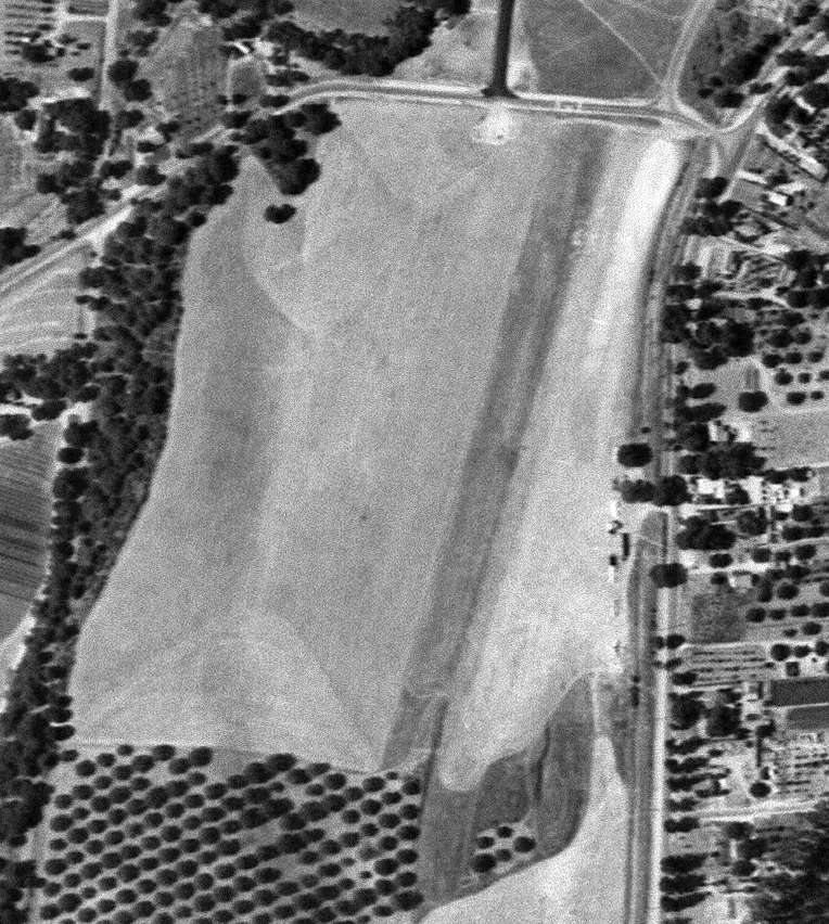
A 1971 aerial photo shows that the northern half of the Henderson Field site had been covered by houses, but the southern half remained clear.
There were a few small buildings along the southeastern edge of the airport site, but it is not evident if they were airport-related.
According to Pete Mason, Henderson Field was no longer listed in the 1972 AOPA Airport Directory.
A 1978 aerial photo shows that the northern half of the Henderson Field site had been covered by houses, but the southern half remained clear.
There were a few small buildings along the southeastern edge of the airport site, but it is not evident if they were airport-related.
Bob Cannon recalled of the Henderson Field site, “coming by and seeing it all being graded up for trailers.”
A 1994 aerial photo showed that the southern half of the airport site had been filled-in by houses at some point between 1978-94.
Thomas Henderson reported in 2004 that the location of Henderson Field was commemorated by the FAA
in the form of the “HENER” aeronautical intersection which sits in the airspace above the former airport.
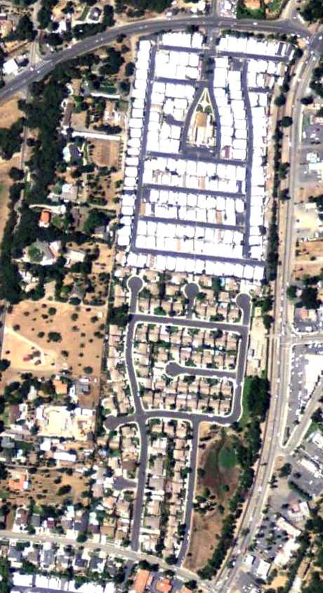
A 5/25/09 aerial photo showed no remaining trace of the former Henderson Field.
Hank Morris reported, “On 9/18/11 the Ojai Museum had a presentation on many Ojai subjects,
one of which was given by Nadine Henderson Webb on Ojai's airport, Henderson Airport.
I'm assuming that Nadine Henderson was the daughter of the airport's namesake Henderson.”
Dan Branstrom reported in 2014, “It is now a mobile home park. I met a woman several years ago whose father developed it.”
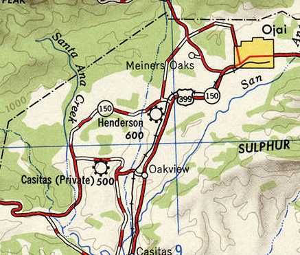
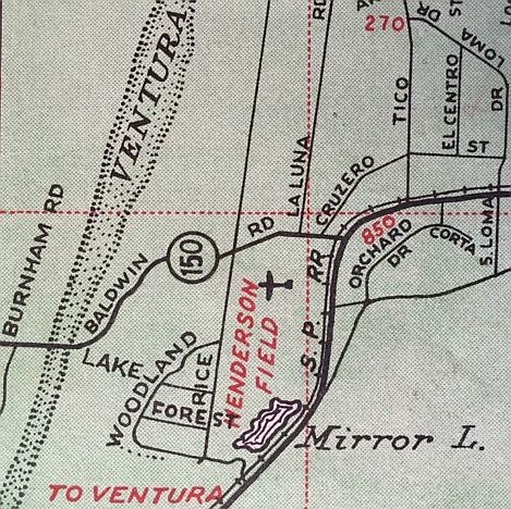
The site of Henderson Field is located southwest of the intersection of Route 150 & Route 33.
____________________________________________________
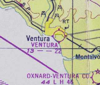
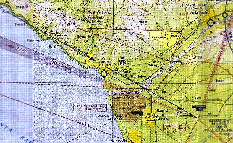
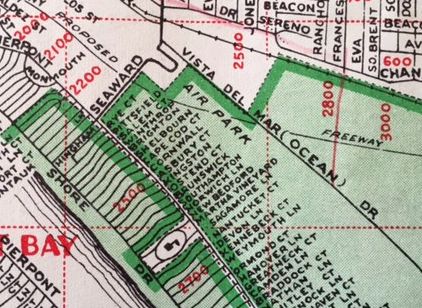
Ventura Airpark, Ventura Beach, CA
34.26, -119.265 (Northwest of Los Angeles, CA)
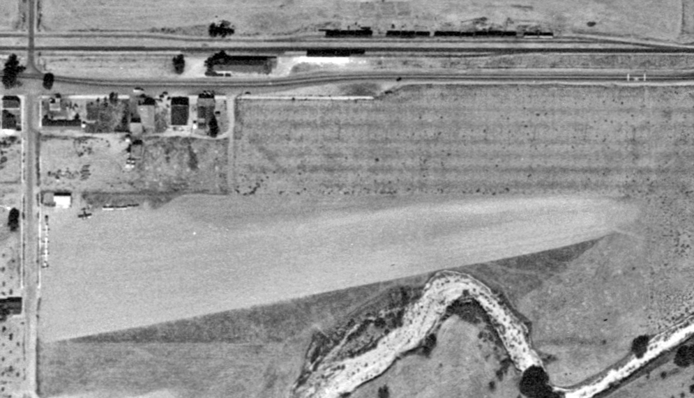
An 8/20/47 USGS aerial photo depicted Ventura Airpark as having an unpaved northwest/southeast runway,
along with possibly a predecessor north/south runway.
The origins of this small general aviation airport date to WW2,
when pilots began using a piece of marginal farmland owned by the Hobson family to operate aircraft
(according to The Aviation Museum of Santa Paula).
It was apparently not yet officially listed as an airport in 1947,
as it was not yet depicted on the February 1947 LA Sectional Chart (courtesy of Chris Kennedy).
Thelma Atkinson reported, “My father-in-law, Donald Atkinson, was a flying enthusiast
who, in partnership with Mr. Heck, operated a charter & flight lesson business at Ventura Air Park post-WWII.”
After learning how to fly during the war, Hobson grandson Walter Hoffman opened an airport on his famland.
Called Ventura Airpark, it was advertised as "The Private Pilots Beach Haven."
The runway stretched 2,250', nestled among fields of sugar beets & lettuce.
When the Air Park opened there were only about 50 houses at Pierpont.
The strip saw use by recreational fliers & local businesses, especially oil companies.
The earliest photo which has been located of Ventura Airpark was an 8/20/47 USGS aerial photo.
It depicted Ventura Airpark as having an unpaved northwest/southeast runway,
along with possibly a predecessor north/south runway.
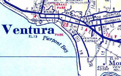
The Ventura Airpark, as depicted on a 1948 Ventura County Street Map (courtesy of Chris Kennedy).
The earliest aeronautical chart depiction of the Ventura Airpark which has been located was on the February 1949 LA Sectional Chart (courtesy of Chris Kennedy).
It depicted Ventura as having a 2,200' unpaved runway.
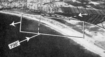
An undated aerial view looking north at Ventura Airpark from the 1950 Air Photo Guide (courtesy of Kevin Walsh).
The guide described Ventura Airpark as having a 2,450' paved Runway 11/29, and listed the manager as Walter Hoffman.
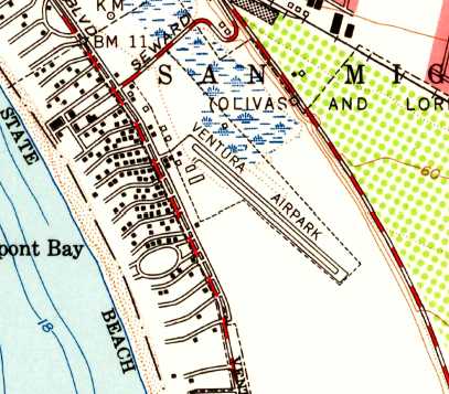
The 1951 USGS topo map depicted Ventura Airpark as having a northwest/southeast runway with a parallel taxiway,
and 2 small buildings on the northwest side.
According to Tom Henderson, the Ventura Airpark "was located along the beach in Ventura.
It was owned by the Hoffman family, who were large landholders in the Ventura area & were also aviation enthusiasts.
At least Walter Hoffman, who was the head of the family from the 1950's & 1960's.
One interesting anecdote - the Hoffmans owned the land for ages & built the airport.
It was not well aligned with the prevailing winds but I'm told it was moderately busy.
My flight instructor was also Walter Hoffman's instructor & he has many stories of flying into Ventura."
Ventura Airpark apparently gained a paved runway at some point between 1949-54,
as it was depicted on the September 1954 LA Sectional Chart (courtesy of Chris Kennedy)
as having a 2,400' hard surface runway.
The 1956 LA Local Aeronautical Chart (courtesy of Tim Zukas) depicted Ventura Airpark as having a 2,400' paved runway.
The last aeronautical chart depiction which has been located showing Ventura Airpark still in operation was on the March 1960 LA Sectional Chart.
It depicted Ventura Airpark as having a 2,400' paved runway.
Ventura Airpark was depicted merely with the label “Air Park” on a 1960 street map (courtesy of Kevin Walsh).
The 1962 AOPA Airport Directory & the 1963 AOPA Airport Directory (according to Chris Kennedy)
described "Ventura Airpark" as having a single 2,450' "road mix" Runway 11/29.
The field was said to offer tiedowns & charter, and the operator was listed as the Rotor Aids Maintenance Corp (a Bell dealer).
A 1962 aerial photo from the UCSB Map & Imagery Laboratory
appeared to depict Ventura Airpark as having a single northwest/southeast runway.
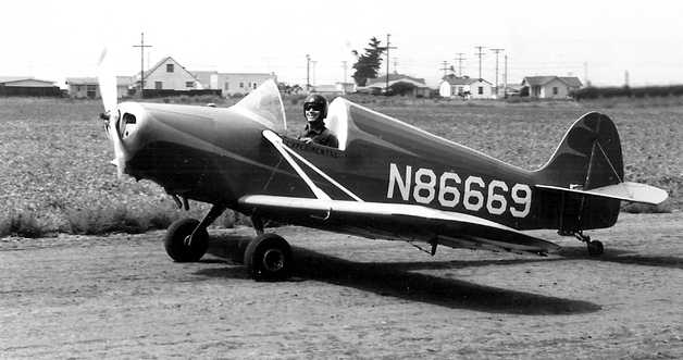
A 1962 photo by George Stimpson of N86669, a Stits Playboy SA-3A, making its maiden flight from Ventura Airpark.
According to Tom Henderson, "Then in the early 1960s the Government decided to turn US 101 into a freeway.
Hoffman saw a business opportunity.
The freeway was built approximately adjacent to the railroad tracks as they came over the Santa Clara River,
along the South end of the city of Ventura, and then along the Beach & up towards Santa Barbara.
I don't know how active Hoffman was in helping select that route,
but he did come to realize that large portions of the Freeway were going to be built above grade.
So lots of fill dirt would be required.
So Hoffman worked a deal whereby the State & Feds would buy fill dirt from him, excavating on the site of the airport.
The resulting hole in the ground was donated to the City to be made into Ventura Marina.
In turn Hoffman was able to develop the Ventura Keys development, with canals & boat slips behind the houses.
It was a monumental commercial success
and instantly became one of the ritzier addresses in Ventura County & remains so today.
Who else besides Walter Hoffman could dream up a scheme to have the State pay him a ton of money
to dig a hole on his property that he could then donate to the City in order to get approval to sell ritzy homes?"
Construction on the Ventura Keys Marina & housing development started in 1963, which presumably was when the airport closed.
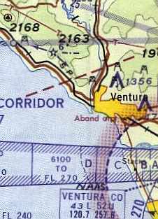
By the time of the 1964 LA Sectional Chart (courtesy of John Voss), the former Ventura Airpark was depicted as "Aband arpt".
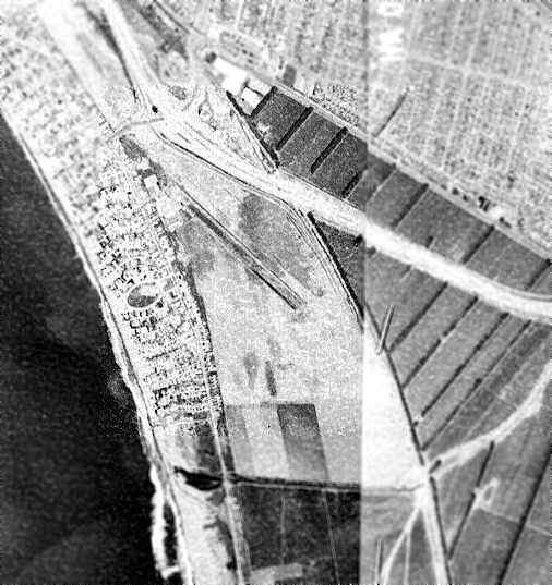
By the time of a 1970 aerial photo from the UCSB Map & Imagery Laboratory,
the the Ventura Keys housing development & marina had erased any trace of the former Ventura Airpark.
Tom Henderson reported in 2004, "As recently as a couple years ago there was a very large aerial photo of the city
in one of the local restaurants that showed the airport in action.
But I think they redecorated recently & that photo is no longer there.
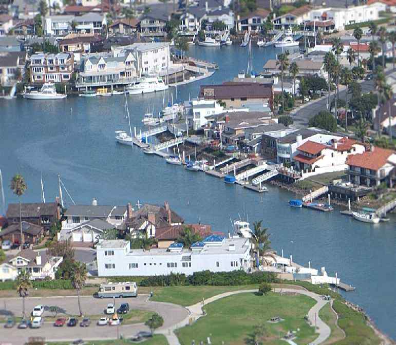
A 2004 aerial view by Clif Simonson of Ventura Keys, the location of the former Ventura Airpark.
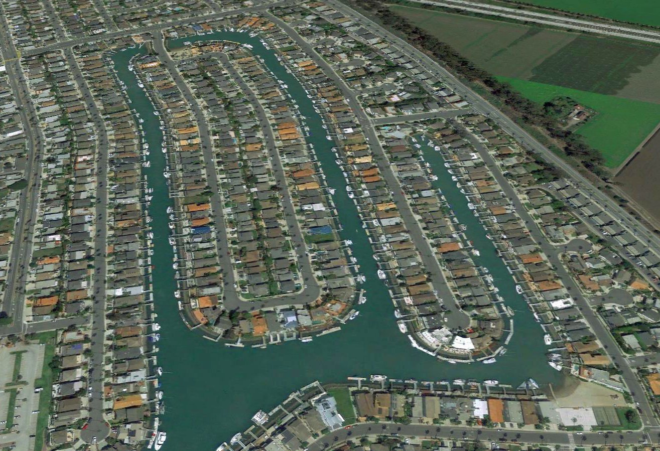
A 2018 aerial view looking north showed the site of Ventura Airpark was covered with the Ventura Keys housing development & marina.
The site of Ventura Airpark is located southwest of the intersection of East Harbor Boulevard & Peninsula Street.
Thanks to Tom Henderson for pointing out this airfield.
____________________________________________________
Conejo Valley Airport, Thousand Oaks, CA
34.18, -118.88 (Northwest of Burbank, CA)
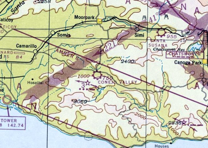
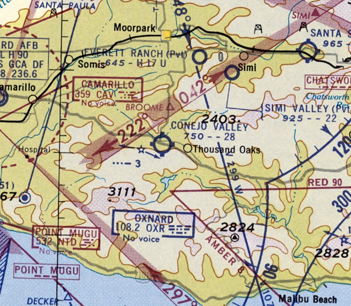
Conejo Valley Airport, as depicted on the February 1947 LA Sectional Chart.
According to Jeanette Berard of the Thousand Oaks Library, “The Janss family was interested in aviation from the 1920s,
when Harold Janss helped found the Western Aviation business in 1926.
In 1947 Gina Janss & actor Michael North were practicing landings at the Janss Ranch Airport (Conejo Valley Airport)
when they were asked to take a ranch worker's son to a Los Angeles hospital for treatment after a horse kicked him.
The 1947 LA Times article is the first one we find that specifically cites the airport.”
Conejo Valley Airport was apparently opened at some point between 1946-47, as it was not yet depicted on the August 1946 LA Sectional Chart.
The earliest depiction which is available of the Conejo Valley Airport was on the Febrary 1947 LA Sectional Chart.
It depicted Conejo Valley as a commercial/municipal airport.
The earliest photo which has been located of Conejo Valley Airport was a 9/13/47 aerial view
which depicted 3 single-engine aircraft & 2 small buildings on the east side of an unpaved east/west runway.

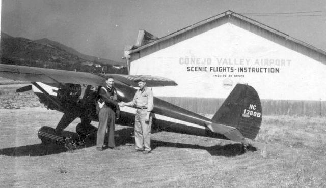
An October 1947 photo of Anna Young & a Cessna 140 in front of a Conejo Valley Airport hangar (courtesy of Meredith Renard).
According to Susan Davidson, “I have a photo of my Dad, Raymond Prewett, holding me in front of a hangar at the Conejo Valley Airport, circa 1948 or 1949.
I was told that my Dad taught flying lessons at the airport.
My photo seems to match up with the landscape in the aerial photo of the airport & runway.”
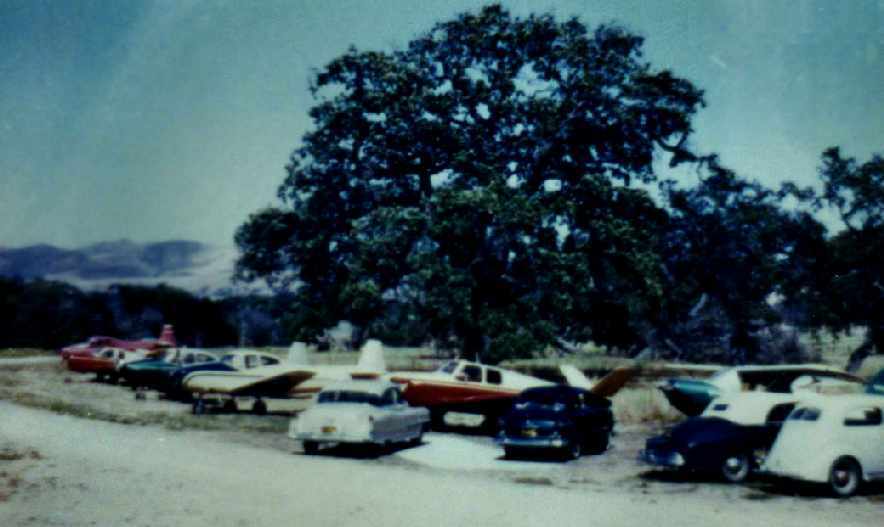
An undated photo of a hangar, the unpaved runway, and 3 light planes at Conejo Valley Airport.
The 1949 Los Angeles Sectional Chart (according to Chris Kennedy) depicted "Conejo Valley" as having a 2,800' unpaved runway.
An undated aerial view looking west at the original location of the Conejo Valley Airport
(from the Local History Collection, Thousand Oaks Library, via Larry Simmer).
The 101 Freeway was not yet in evidence, so the photo was evidently pre-1950.
It depicted Conejo Valley Airport as having a single unpaved east/west runway, with 2 hangars & 3 light planes on the east end.
The September 1950 LA Sectional Chart depicted Conejo Valley as having a 3,200' unpaved runway.
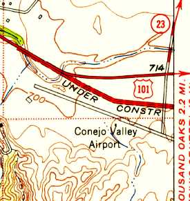
The 1950 USGS topo map depicted Conejo Valley Airport as having a single northwest/southeast runway,
adjacent to the south side of the 101 freeway which was labeled as “Under construction”.
An article by John Mitchell in the 12/15/03 issue of the Ventura County Star provided some recollections about the Conejo Valley Airport.
Leroy Aronson grew up in Thousand Oaks, and said the airfield near present-day Moorpark Road & Thousand Oaks Boulevard had 2 locations.
The first location, he said, paralleled Ventura Road (Thousand Oaks Boulevard).
Then, in 1952, when the state ran a divided highway through the small town, the airfield was moved to the south side of the highway, near what is now the golf course.
"I remember a T-shaped hangar at one end of the runway," Aronson said. "Dad had a Piper Cub & I would take rides with him.
Also, I remember one time when a bunch of us kids were at the airport & watched them shoot part of a 'Francis the Talking Mule' movie with Donald O'Connor."
Bob Morrison recalled the airport as stretching from Thousand Oaks Boulevard to where the restaurant is today at the Los Robles Golf Course.
"Clete Roberts, the newsman, used to keep his Stearman biplane there," Morrison said.
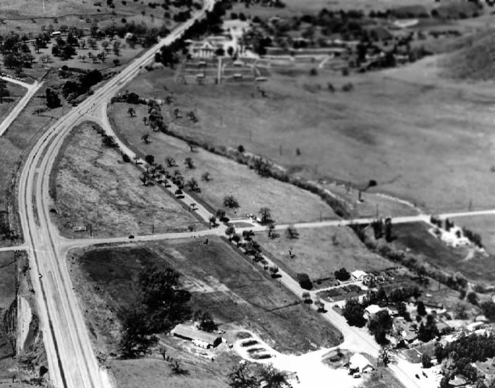
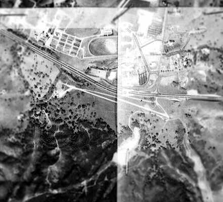
A circa 1952-57 aerial view looking west taken for the Janss Corporation (courtesy of Jeanette Berard of the Thousand Oaks Library).
The remains of the runway of the 1st location of the Conejo Valley Airport are visible running from the bottom to the upper-left,
with a former hangar still visible (small white building along the clearing at the bottom).
The runway of the 2nd location of the Conejo Valley Airport is visible along the left side of the photo, just left of the bend in the road.
Bob Cannon recalled that in the 1950s, "The Thousand Oaks area was almost totally open grazing land with only a few farms.
Conejo Valley was interesting in that a creek crossed midway down the strip.
At that point there was a bridge that served as part of the runway."
The 1956 LA Local Aeronautical Chart (courtesy of Tim Zukas) depicted Conejo Valley as having a 2,600' unpaved runway.
A circa 1950s photo of a pilot wearing a parachute being congratulated in front of a Luscombe 8F at Conejo Valley Airport.
A circa 1950s photo by Bill Aronson (courtesy of Pete Mason) of a fly-in at Conejo Valley Airport.
Sven Larson recalled, "My family was a 'pioneer' family in the Conejo Valley, moving there in 1958.
I remember the Conejo Valley Airport which could be seen on the southwest side while driving on Highway 101.
I don't recall it being particularly active."
According to Jeanette Berard of the Thousand Oaks Library, “Public notice was made of intent to abandon the strip in 1959.
In the 5/4/59 Conejo News, Janss Investments announced plans to build the new Rancho Conejo Airport
and to abandon the older airstrip, and move the hangars as soon as the new strip was finished.”
The last aeronautical chart depiction which has been located of Conejo Valley Airport was on the March 1960 LA Sectional Chart,
although Conejo Valley Airport may have already been closed by that point.
It depicted Conejo Valley as having a 2,800' unpaved runway.
Accornding to Larry Simmer, Conejo Valley Airport was located at "the corner of Thousand Oaks Boulevard & Moorpark Boulevard, the main entrance to Thousand Oaks.
The winding road is the original California Highway 101/Thousand Oaks Boulevard, which became a freeway in the 1960s & is offset to the left.
The airstrip is heading into what is now the Las Robles Golf Course, built in the 1960s."
A 1961 aerial photo from the UCSB Map & Imagery Laboratory appeared to depict the Conejo Valley Airport as consisting of a single unpaved northwest/southeast runway,
but it was not apparent if the airport was still in operation by that point.
According to Jeanette Berard of the Thousand Oaks Library, “The airport was closed by 1962.”
Conejo Valley Airport was no longer listed among active airfields in the 1962 AOPA Airport Directory.
A 1962 photo of the location filming for the Elvis MGM movie “It Happened at the World's Fair”,
which appears to have used the Conejo Valley Airport, possibly after its closure.
According to Presley Film Historian Bill Bram, “Elvis filmed at several airports in Ventura County.”
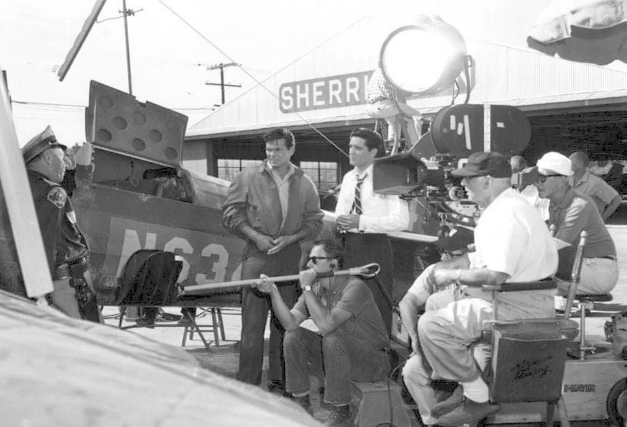
A 1962 photo of Elvis Presley during the filming for the MGM movie “It Happened at the World's Fair” in front of a Conejo Valley Airport hangar.
Conejo Valley Airport was no longer depicted on the 1964 LA Sectional Chart.
A 1980 aerial view showed that a golf course had covered the site, with no trace remaining of the former Conejo Valley Airport.
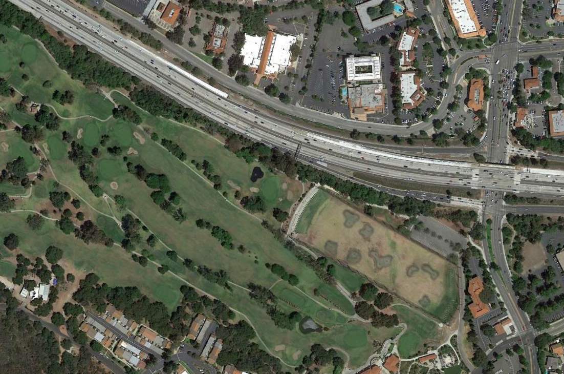
A 2015 aerial view showed the site of Conejo Valley Airport had been redeveloped with buildings, Highway 101, and the golf course,
and not a trace appears to remain of the former airport.
____________________________________________________
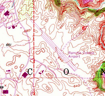
Rancho Conejo Airport, Thousand Oaks, CA
34.195, -118.92 (Northwest of Burbank, CA)
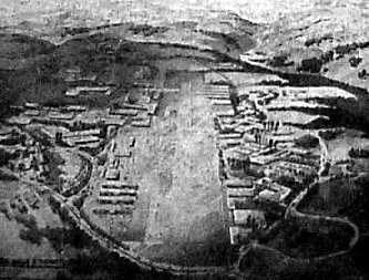
A 1960 artist's concept of the planned Rancho Conejo Airport (from the Local History Collection, Thousand Oaks Library, via Larry Simmer).
According to Jeanette Berard of the Thousand Oaks Library, “In the 5/4/59 Conejo News,
Janss Investments announced plans to build the new Rancho Conejo Airport
and to abandon the older airstrip [the Conejo Valley Airport], and move the hangars as soon as the new strip was finished.”
The Rancho Conejo Airport was built to sustain aerospace manufacturing & research operations
of a nearby new industrial park, where Northrop was the primary tenant.
Northrop had just built their Institute of Technology & Northrop Corporation Ventura Division, where much of their work was related to spaceflight.
The opening of the Rancho Conejo Airport was proclaimed by a banner headline
across the top of the 5/5/60 issue of the LA Times (courtesy of Larry Simmer), which said "Janss Corp. Opens Executive Airport".
The article said, "The finest executive aircraft facility on the West Coast was opened here today by the Janss Corporation.
Set among the rolling, oak-dotted hills of this beautiful valley,
Rancho Conejo Airport will serve the needs of the fast-moving executives of the space-age industries
moving into Janss Corporation's Rancho Conejo Light Manufacturing & Research Center.
The facility has a completely surfaced & lighted runway measuring 4,500' in length.
The airport was specifically designed to meet the needs of flying executives, many of whom pilot their own planes."
A "Press Party" on 5/5/60 celebrating the opening of the airport included a "jet salute by planes from Oxnard AFB."
According to an article by John Mitchell in the 12/15/03 issue of the Ventura County Star,
Jack Valenti was president of Murray Aviation & had a 5-year lease from the Janss Corporation
to operate a charter service & give flying lessons at Rancho Conejo Airport.
"Northrop was at the end of the runway," he said. "We flew their people working on the Gemini & Apollo programs to El Centro.
Also, we had charters to Los Angeles, San Francisco and other places."
Valenti remembers being filmed while in a twin-engine Skymaster moving down the runway.
That piece of film, he said, ended up being in the opening sequences of the TV program "American Bandstand."
Sven Larson recalled, "My family was a 'pioneer' family in the Conejo Valley. We were also an aviation family.
Dad kept his 1943 Beech D17S Staggerwing in a hangar at the Rancho Conejo Airport, a 10 minute or so drive from our home.
He always complained that the runway orientation was wrong for the prevailing winds resulting in a perpetual crosswind."
Rancho Conejo Airport was not yet depicted on the September 1960 LA Sectional Chart.
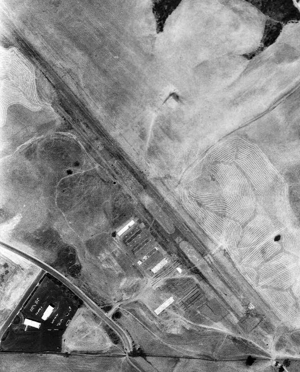
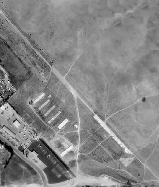
A 2/12/61 aerial view (from the UCSB Library) depicted Rancho Conejo Airport as having a single northwest/southeast paved runway along with several hangars on the south side of the field.
A dozen light single-engine aircraft were visible on the field as well.

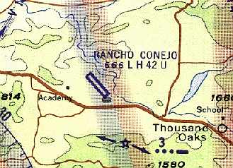
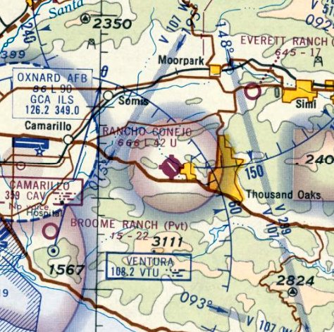
The earliest aeronautical chart depiction which has been located of Rancho Conejo Airport was on the March 1961 LA Sectional Chart.
It depicted Rancho Conejo as having a 4,200' unpaved runway.
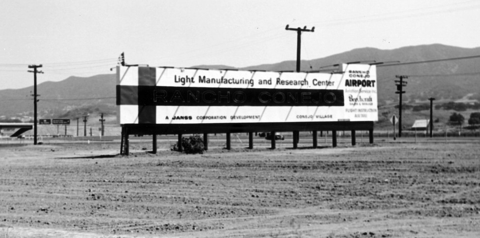
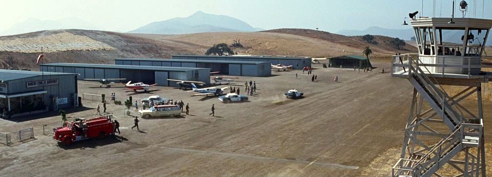
A circa early 1960s billboard advertising the “Light Manufacturing & Research Center, Rancho Conejo Airport, Aviation Service Inc., Beechcraft Sales and Service, flight instruction, air taxi."
The 1962 AOPA Airport Directory described Rancho Conejo as having a single 4,265' asphalt Runway 12/30, and listed the operator as Aviation Services Inc.
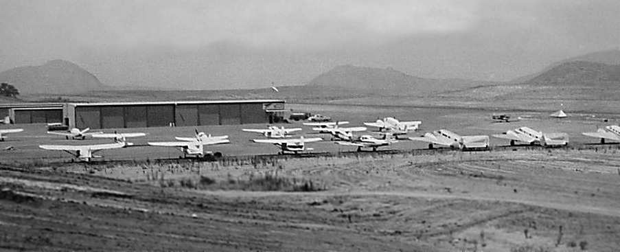
An early 1960s view of the ramp at Rancho Conejo Airport (from the Local History Collection, Thousand Oaks Library, via Larry Simmer), with four Beech 18s among the parked aircraft.
Keith Wood remarked, “I'd be willing to bet that three of the 4 Beech 18s were the planes used in filming 'It's a Mad, Mad, Mad, Mad World'.
Note that they had the same basic paint scheme as shown in the film,
and Tallmantz had at least two 18s on camera (note that the one which was flown through the billboard had protective bars on the windscreen, not seen in most other shots).”
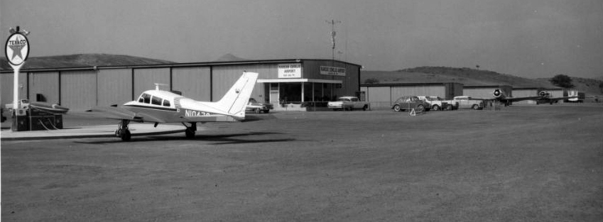
A circa 1960s view of the Cessna 310 & 2 T-6 Texans on the Rancho Conejo Airport ramp.
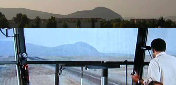
The top of this composite picture by Gerry Chudleigh is a 2003 photo taken from the site of the former Rancho Conejo Airport,
showing an unnamed mountain to the northwest of the former airport.
The lower portion is a scene from the 1963 movie "It's a Mad, Mad, Mad, Mad World", showing the same mountain from inside a "control tower" built for the movie.
The top of this composite picture by Gerry Chudleigh is a 2003 photo taken from the site of the former Rancho Conejo Airport,
showing Adventist Hill, west of the former airport.
The lower portion is a scene from the 1963 movie "It's a Mad, Mad, Mad, Mad World", showing the same mountain, behind the hangars on the left.
The top of this composite picture by Gerry Chudleigh is a 2003 photo taken from the site of the former Rancho Conejo Airport,
showing the Santa Monica Mountains to the south of the former airport.
The lower portion is a scene from the 1963 movie "It's a Mad, Mad, Mad, Mad World",
The 1963 movie, "It's a Mad, Mad, Mad, Mad World" included several airport scenes which were shot at Rancho Conejo Airport.
The movie depicted Mickey Rooney & Buddy Hackett chartering a twin-engine plane
and flying it to an airport loudly identified by the man in the control tower as "Rancho Conejo Airport".
Buddy Hackett's character ended up flying the plane after the pilot got drunk & passed out.
A man in the control tower gave Hackett's character flying instruction over the radio.
Although several other airport scenes in the movie may have been filmed at other airports (Chino & Sonora),
a comparison of movie scenes with the present-day topography led Gerry Chudleigh to conclude that several scenes were indeed filmed at Rancho Conejo.
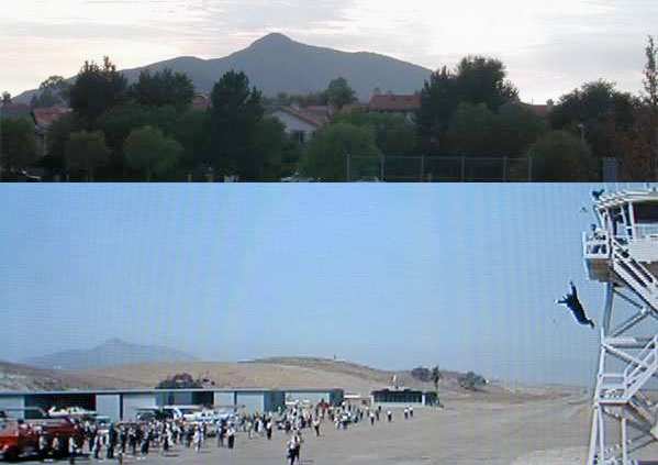
A still from the 1963 movie “It's a Mad, Mad, Mad World” (courtesy of Jim Megee), showing the Rancho Conejo hangars & the control tower constructed for the movie.
Nearby resident Jay McKee pointed out that the "control tower" filmed in the movie, "was built by the studios specifically for the fliming of these sequences.
Rancho Conejo never had a control tower. This control tower looks like no other FAA or private control tower I have ever seen - from any era.
The reason it looks so different is that it is made entirely out of wood.
In all probability, it didn't even have glass in the windows.
The cameras were positioned in this temporary tower to shoot the (elevated) scenes of the Beech approaching from the distance & 'buzzing' the tower.
The interior scenes with the actors in the control tower were filmed in a sound stage in a mockup of the tower interior.
The footage that was shot on location from the tower was projected in the background while the actors did their bits & 'reacted' to the passing plane
(notice how even & controlled the lighting is on the actors in the control tower).
The FAA would have freaked if someone were to build a real control tower THAT close to the flightpath/runway centerline.
Notice that the tower is positioned between the runway & taxiway centerlines. Definitely a temporary structure.
I'm almost positive it was dismantled as soon as they wrapped up shooting at the field."
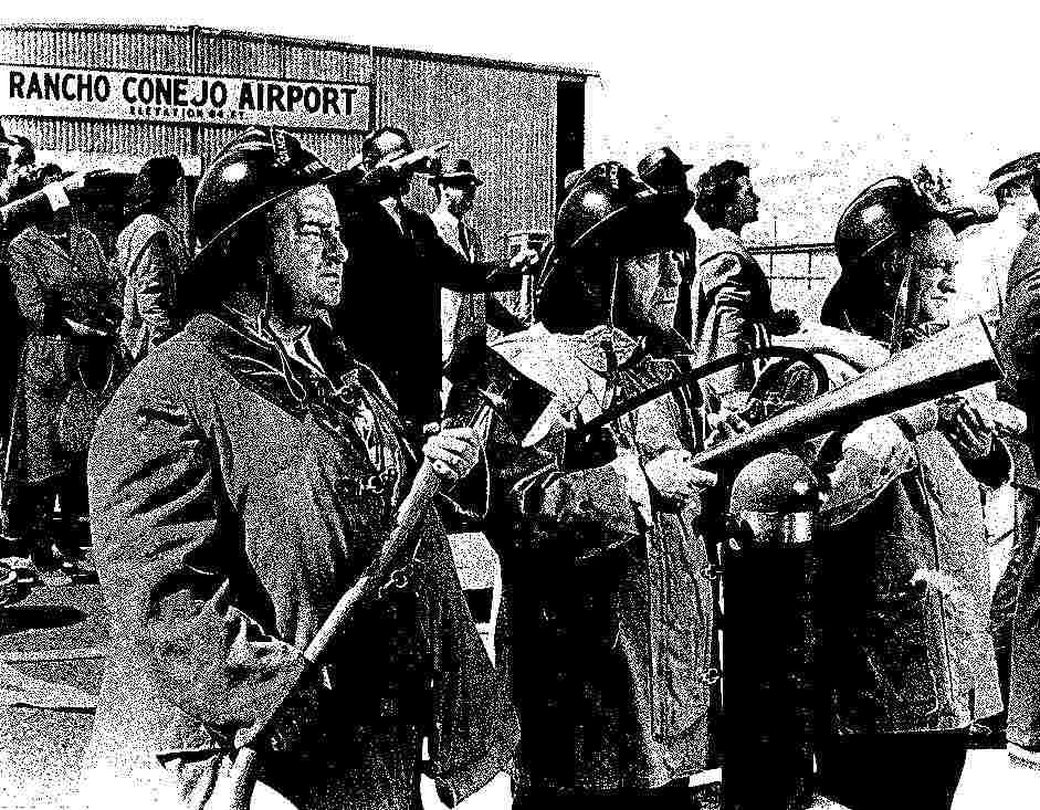
A 1963 photo (courtesy of Rodney Gehring) of the Three Stooges dressed in firefighter gear in front of a Rancho Conejo Airport hangar,
during the filming at the airport of the movie “It's a Mad, Mad, Mad, Mad World”.
Steve Hix recalled, “From September 1964 through June 1968 I attended Newbury Park Academy,
which is sited near the base of Adventist Hill west of the airport.
I remember hiking over to the airport from the school on afternoons when I had no classes & was off work;
about as often as I could manage it, being a typical aviation-mad kid of the era.
On one particularly fine day, I heard a couple of big V-12 engines,
and once I got over the hill, found that a P-38 was landing, fueling, and taking off, repeatedly.
TallMantz aviation was filming flying sequences for 'Von Ryan's Express', a WW2 film,
and I think that Frank Tallman was doing the flying.
During one fueling break, he let me pop up the rear ladder & look in the Lightning's cockpit.
It was alway pleasant to hang around the airport; nobody seemed to mind the kid,
and several would talk about flying & airplanes as they did chores or worked on their planes.”
The Aerodromes table on the August 1964 LA Local Aeronautical Chart (courtesy of Donald Felton)
listed Rancho Conejo as having a single 4,264' asphalt runway, along with the remark, "Glider operations at & in vicinity."
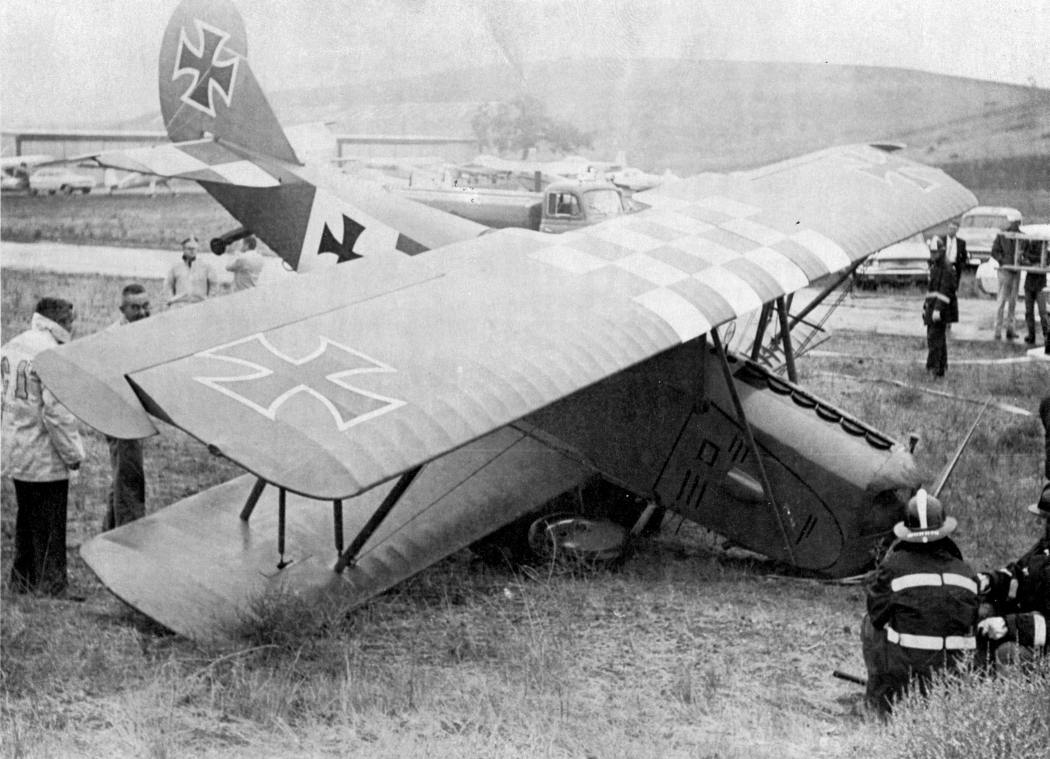
A 10/28/64 photo of a World War I Fokker biplane (possibly a replica?) after it crashed at the Rancho Conejo Airport.
The pilot, James Appelby, was uninjured. The plane was used for the filming of the Four Star Television Corporation series "Hellcats."
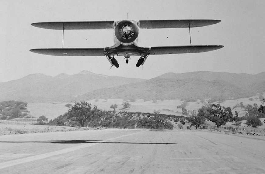
A circa 1965 photo by Frank Knight of Roy Larson's Beech D17S Staggerwing, making a low pass over the runway at Rancho Conejo Airport.
“The view is southerly with the Santa Monica Mountains in the background.
The photo was taken specifically for publication in the book Staggerwing! published in 1967 & authored by Robert Smith.”
The August 1965 LA Sectional Chart depicted Rancho Conejo as having a 4,200' paved runway.
Guy Stewart recalled, “My dad used to own a Cessna 175 that we flew out of Rancho Conejo in the 1960s. I took my first lessons there before it closed.
There was a music show that filmed there, a weekly series for teenagers.”
Ironically, even though the Rancho Conejo Airport had been opened with much fanfare in 1960,
an article in the 10/20/65 issue of the Oxnard Press Courier (courtesy of Larry Simmer)
described how the Janss Corporation (the same company which had built the airport)
already planned to close it, after a mere 5 years in operation.
The article was entitled "Closing of Conejo Airport barrier to moon trip?"
Executives of the North American Corporation (which conducted spaceflight related business nearby)
were quoted in the article as explaining how the proximity of an airport had been a prime factor in their decision to locate their operations nearby.
They also explained how the closing of the airport could delay their work on the Apollo moon-landing project.
A temporary restraining order was filed in 1965, blocking the closure of the airport.
It was obtained by Murray Aviation, which said that it had a lease at the airport which ran through 1967.
However, according to Larry Simmer, "the airport was closed by late 1965 or early 1966."
According to an article by John Mitchell in the 12/15/03 issue of the Ventura County Star,
Valenti's bid for an injunction to keep the airport open failed, but he continued to operate from the field.
Janss sent in bulldozers to chew up the taxiway & runway,
but planes continued to land "in the parking lot, on scraps of runway & anywhere else there was an open patch of ground," the newspaper reported.
"All I need is 150 feet & I'm still in business," Valenti vowed.
However, after 5 days, Valenti threw in the towel & moved his aircraft to Ventura County Airport at Oxnard.
Other fliers relocated to Santa Paula, Oxnard or Van Nuys.
Valenti said he eventually won damages from the Janss Corp.
He can't remember how much money his company got, but said it was enough to buy an airplane.
According to Larry Simmer, "To my recollection the Janss Corporation came to view the airport which they owned
as an impediment to their land sales opportunities.
At one point a large section of the property was sold to MGM Studios for a planned new large film studio site
but MGM ran into financial difficulties & sold the property back to Janss.
The Janss family has always been a land development company first & foremost."
Sven Larson recalled, "It was a very sad day when the Janss Corporation finally closed the airport
on account of the proposed new MGM sound studios which were never built."
Guy Stewart recalled, “ My dad bought some of the hangars that I helped him tear down after the closing.”
Rancho Conejo Airport was still depicted on the 1967 USGS topo map.
Rancho Conejo was depicted as "Abandoned Airport" on the 1967 LA Sectional Chart (courtesy of Chris Kennedy).
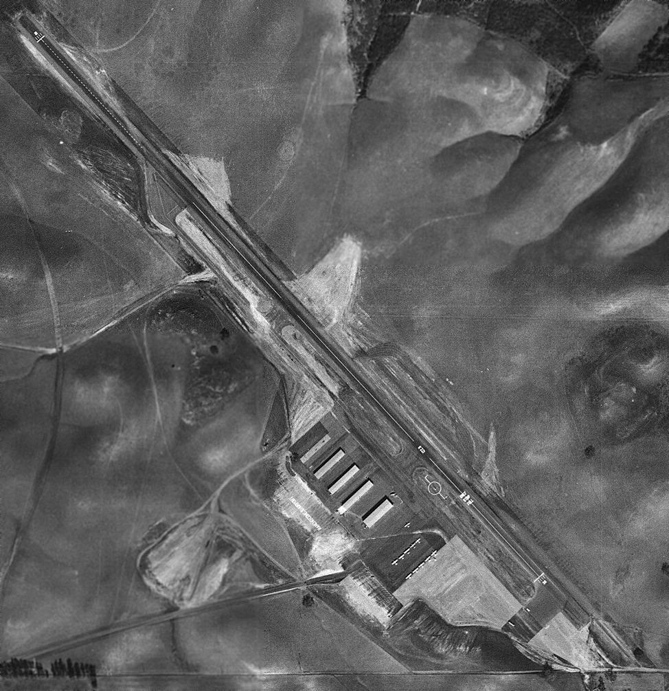
An 8/13/67 aerial view showed the remains of the Rancho Conejo runway & the foundations of the hangars.
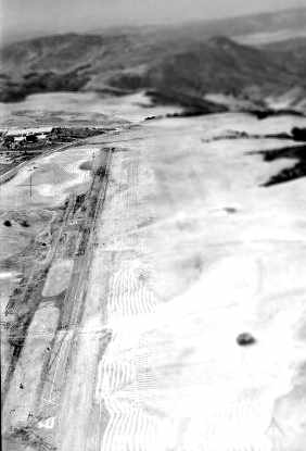
A 1967 aerial view looking northwest at the remains of the Rancho Conejo runway (courtesy of Jay McKee).
The original caption read, “The open land that was long held by MGM for potential use as a shooting location.
Photo taken after the airstrip was partially bulldozed to prevent illegal landings.”
Jay McKee recalled, "As a kid I would occasionally ride my bicycle down the abandoned runway. This must have been 1973-81.
Most of the asphalt of the runway was removed long before then, but the southeast end (100 yards of it) was still paved asphalt.
Someone had run a plow or something through this asphalt criss-cross across the remaining 100 yards at wide intervals,
and 2 foot weeds were growing up through these 'cracks'.
Though no longer white, I could still make out the runway number 30 on the faded pavement.
Although the paint & runway surface had both faded to the same dirty shade of 'dirt',
the marking paint was thick & appeared raised on the asphalt.
At that time the foundations to the hangars & semi-circular fueling pad were still there.
Broken pieces of tile from the floor of the old FBO were scattered about. It was a fascinating place to wander around.
There was no airport easily accessible from Newbury Park for a kid on a bicycle,
and I often wished they had never closed Rancho Conejo."
A 1980 aerial view showed the remains of Rancho Conejo Airport.
The pavement had been removed from the majority of the runway, but a portion still remained intact on the southeast end.
All of the hangars & other airport buildings had been removed, but their foundations were all still evident.
Amazingly, this 1983 photo by Jeff Niven looking southeast at the site of the Rancho Conejo Airport
shows the same exact perspective as the 1965 photo [several paragraphs above] of the Staggerwing taking off.
Note the large oak tree in the center of the photo [which was visible under the right wing of the Staggerwing].
Also, one of the diagonal runway cuts is clearly seen in the foreground.
Jeff Niven observed, “It is true that developers cut numerous diagonal cuts through the runway
to encourage the stubborn pilots to abandon an airfield.
The sad part of the story of Rancho Conejo is that after they kicked out the pilots & cut up the runway,
the developers changed their minds & did not use the land until about 25 years later!
The property sat vacant with the damaged runway for many years.
One day I saw a pilot try to land on the old runway.
He was very low before he must have noticed the damaged surface
because the pull up maneuver he made was very impressive!”
A 1983 photo by Jeff Niven looking northwest along the remains of runway at Rancho Conejo,
with what appear to be the former Northrop buildings in the background.
According to Jeff, “This photo was taken near the same location
as the shot of the guy jumping from the tower in the 'Mad, Mad World' Movie.
I was working for a small aerospace company in California.
Our work required that we do some inert submunition drop tests from an altitude of 1,000'
on various surfaces such as dirt, concrete, asphalt, etc.
On this particular day we dropped numerous items onto the old runway, the concrete pads from the old buildings & local soil.
We tried various techniques such as helium balloons,
but the best was when we hired a helicopter to drop them as he hovered over the old airfield.
We did run into trouble, however. As noted in the local police report, a call came in from a local resident
that there was a drug delivery in progress from a hovering helicopter,
and if they hurried they could catch the drug dealers in the act!
Well they hurried to our location just after the helicopter had flown off.
There we were walking around looking at items that had just been dropped.
We had a lot of explaining to do as we tried to explain to the cops what we were doing.
We had dropped bags of white flower to mark the impact areas
and that was what the woman called saw from her house before she called the police.
Of course the flour had to be tested, but the biggest problem was trying to convince them
that the bomblets that were scattered around area were inert.
Luckily one of the policemen recognized me from High School & knew that I was not a troublemaker.
That seemed to calm the situation tremendously.
The owner of the old airport at that time was Shapell Industries, who later would build homes on the property.
We had called Mr. Shapell earlier & got his permission to do the drop test on his property.
That fact kept us from really getting into trouble.”
The last photo which has been located showing the remains of Rancho Conejo Airport was a 1989 aerial view looking north.
The pavement had been removed from the majority of the runway, but a portion still remained intact on the southeast end.
All of the hangars & other airport buildings had been removed, but their foundations were all still evident.
Sven Larson recalled, "The remnants of the runway were clearly visible from the air through the late 1980s
before the area was developed into housing."
The 1994 USGS aerial photo of the site showed that it had been densely redeveloped with housing, and not a trace remained of the former airport.
A 2015 aerial photo showed no trace remaining of Rancho Conejo Airport.
The site of Rancho Conejo Airport is located northwest of the intersection of North Ventu Park Road & Lawrence Drive.
Thanks to Tom Nalevanko for pointing out Rancho Conejo.
____________________________________________________
____________________________________________________
This site covers airfields in all 50 states.