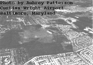
Abandoned & Little-Known Airfields:
Maryland: Northwestern Baltimore area
© 2002, © 2024 by Paul Freeman. Revised 1/22/24.
This site covers airfields in all 50 states: Click here for the site's main menu.
____________________________________________________
Please consider a financial contribution to support the continued growth & operation of this site.
City Line Airport (revised 12/28/16) - Curtiss-Wright Airport / Pimlico Airport (revised 1/22/24) - Hoby Wolf Airport (added 2/8/22)
Park Heights Flying School / Handler Field / Handler Airport / Service Field (revised 2/9/20) - Rutherford Field / Baltimore Airport (revised 8/4/19)
____________________________________________________
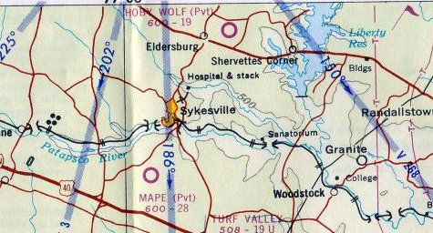
Hoby Wolf Airport (2MD5), Eldersburg, MD
39.37, -76.71 (Northwest of Baltimore, MD)
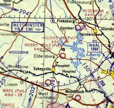
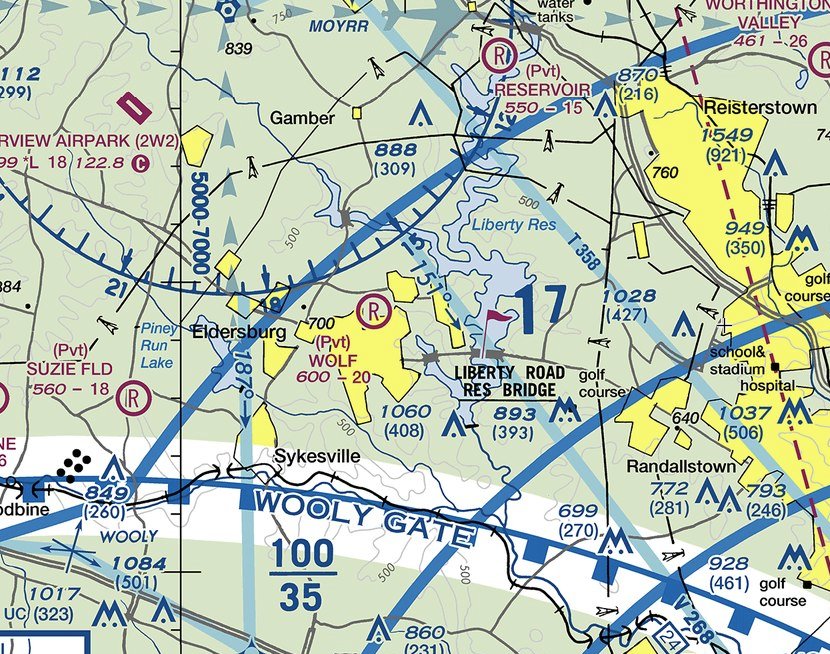
Hoby Wolf Airport, as depicted on the 1964 Washington Sectional Chart.
According to his 2010 obituary, Hoby Wolf “earned his private pilot's license in 1945.”
According to Ryan Miller, “Hoby Wolf Airport opened sometime in the 1950s & was originally a public-use airport under the identifier 1W5.
The airport was located on the 77-acre farm of Hoby Wolf. The airport had unusual grading to it, with a single turf runway which was not level.”
Hoby Wolf Airport was not yet depicted on the 1962 Washington Sectional Chart.
According to its FAA Airport/Facility Directory data, Hoby Wolf Airport was activated in June 1964.
The earliest depiction which has been located of Hoby Wolf Airport was on the 1964 Washington Sectional Chart.
It depicted Hoby Wolf Airport as a private airfield having a 2,200' unpaved runway.
According to his 2010 obituary, “For more than 50 years, Hoby Wolf lived on a 71-acre farm in South Carroll,
where he owned & operated Wolf
Airport, which featured a single 2,200' grass runway.
Wolf
lived in a sprawling Colonial home facing the runway where he &
his fellow pilots would take off.
In addition to restoring vintage airplanes, Wolf enjoyed hosting numerous charity events at his airport.”
The April 1965 Washington Local Chart depicted Hoby Wolf Airport as a private airfield having a 1,900' unpaved runway.
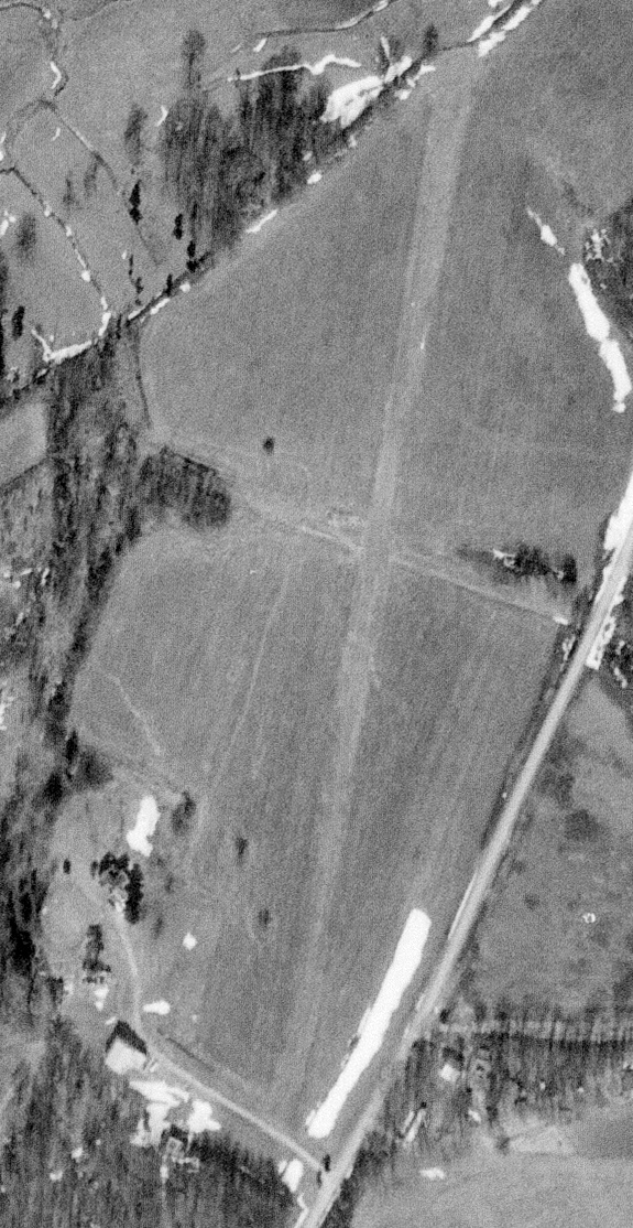
The earliest photo which has been located of Hoby Wolf Airport was a 2/21/66 USGS aerial view.
It depicted Hoby Wolf Airport as having a single northeast/southwest unpaved runway, with a few small buildings on the southwest side.
There were no aircraft visible on the field.
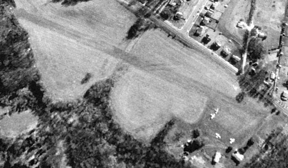
The only photo which has been located showing aircraft at Hoby Wolf Airport was a 1992 USGS aerial view looking east.
It depicted 4 light single-engine aircraft on the south end of the field.
According to Ryan Miller, “There was a fatal accident in April 1995, and the owner decided to make the airport private sometime shortly thereafter.”
According to his 2010 obituary, Hoby Wolf “continued flying until about a decade ago, family members said.”
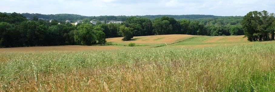
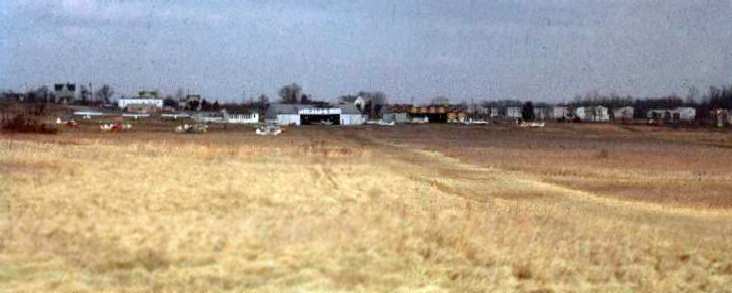
A 2010 photo looking northwest along Hoby Wolf Airport's rolling runway.
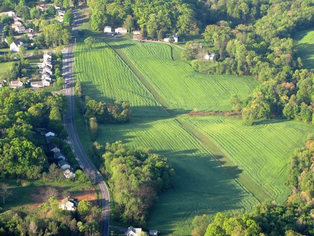
A 2010 aerial view looking south along Hoby Wolf Airport's rolling runway. There were no aircraft visible on the field.
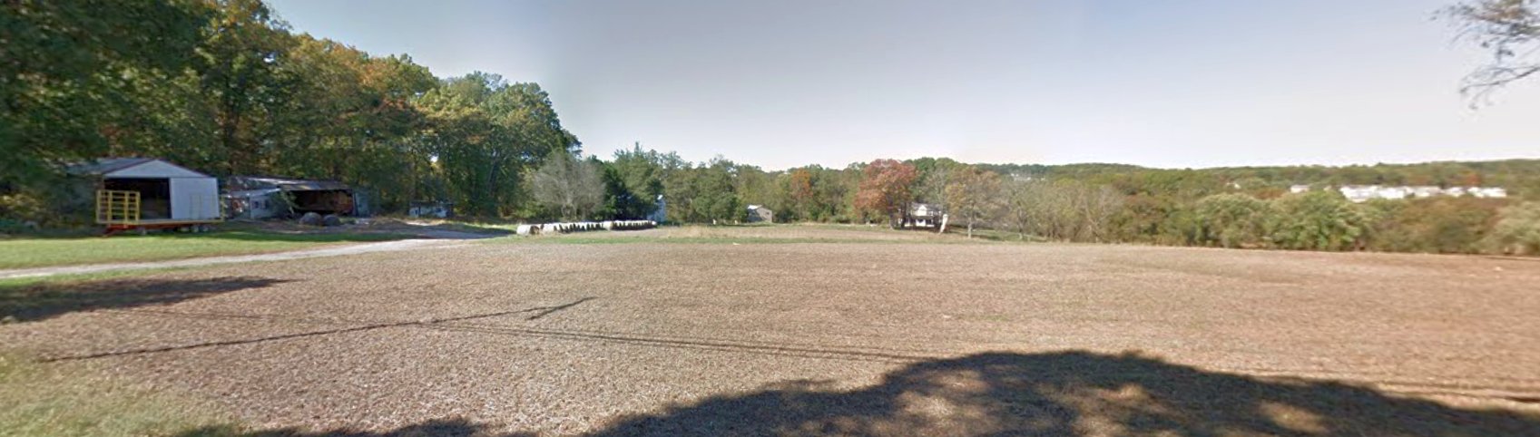
A 2017 photo looking west at the south end of Hoby Wolf Airport.
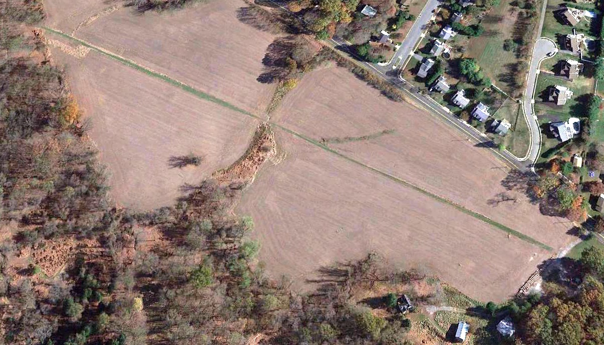
A 2019 aerial view looking east at Hoby Wolf Airport.
The 2022 Washington Terminal Chart depicted Hoby Wolf Airport as a private airfield having a 2,000' unpaved runway.
Ryan Miller reported in 2022, Wolf's “son, Dan Wolf, is in the process of selling the property for residential development.
Hoby Wolf Airport is being officially deactivated; its current identifier is 2MD5.
The 1/27/22 [aeronautical] charts should be the last to depict the airport.”
____________________________________________________
City Line Airport, Pikesville, MD
39.37, -76.71 (Northwest of Baltimore, MD)
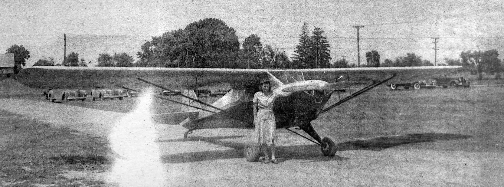
The City Line Airport, as depicted on the 1929 "Rand McNally Standard Map of MD with Air Trails" (courtesy of Chris Kennedy).
Photo of the airport while open has not been located.
This commercial airfield was in operation during the same time frame
and in very close proximity to the Park Heights Flying School Airfield (located less than 1 mile to the northwest).
The date of establishment of the City Line Airport has not been determined.
The earliest reference to the City Line Airport which has been located
was on the 1929 "Rand McNally Standard Map of MD with Air Trails" (courtesy of Chris Kennedy).
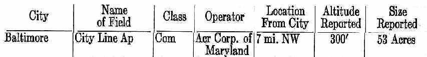
It described the City Line Airport as a 53-acre commercial airfield
operated by the Aircraft Corporation of Maryland.
City Line Airport, as depicted on the 1929 Washington to New York City Air Navigation Map #3.
City Line Airport was apparently closed at some point between 1929-30,
as it was not depicted on a circa 1930 Cram's street map (courtesy of Greg Stec),
listed in the 1931 Commerce Department Descriptions of Airports & Landing Fields (courtesy of David Brooks),
depicted on the May 1932 Washington Sectional Chart, or the 1943 or 1946 USGS topo maps.
By the time of a 1957 aerial photo, not a trace appeared to remain of City Line Airport.
As seen in the 1993 USGS aerial photo, the presumed location of City Line Airport has been covered by a school & dense residential development.
Not a trace appeared to remain of the former airport.
A 2015 aerial photo showed no trace remains of City Line Airport.
The exact location of City Line Airport has not been precisely determined,
but its depiction on the 1929 Rand McNally map would place it roughly along Seven Mile Lane,
roughly midway between Park Heights Avenue & Reisterstown Road.
____________________________________________________
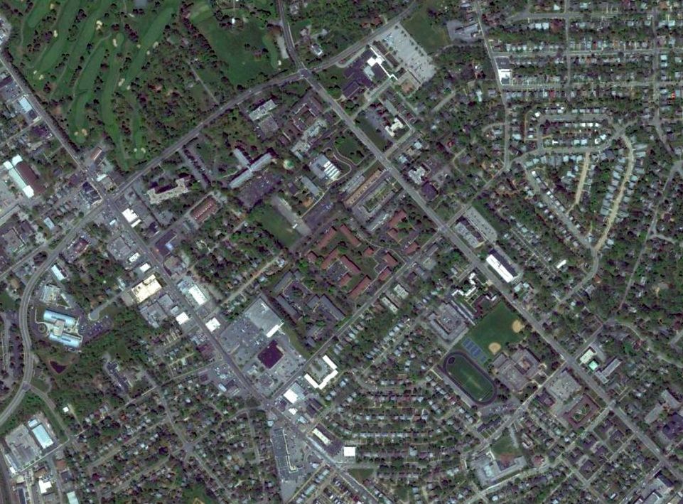
Park Heights Flying School Airport / Handler Field / Handler Airport / Service Field, Pikesville, MD
39.386, -76.716 (Northwest of Baltimore, MD)

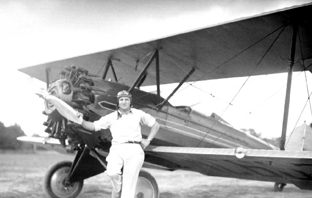
A 1928 photo (courtesy of Mike Hull) of a group in front of a JN-4 Jenny at the Park Heights Flying School:
unknown, Louis Vollman, Warner Hull, Winfield Peck, George Hain, Mrs. Peck, and unknown.
The date of establishment of this flying school airfield has not been determined.
The earliest depiction which has been located of the Park Heights Flying School field which has been located
was a 1928 photo (courtesy of Mike Hull) of a group in front of a JN-4 Jenny at the Park Heights Flying School:
unknown, Louis Vollman, Warner Hull, Winfield Peck, George Hain, Mrs. Peck, and unknown.
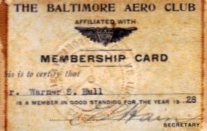
Warner Hull's 1928 membership card (courtesy of Mike Hull) from Park Heights' Baltimore Aero Club.
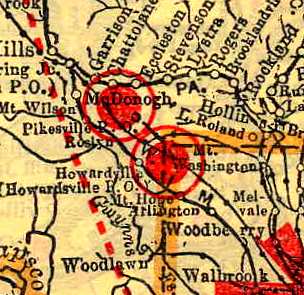
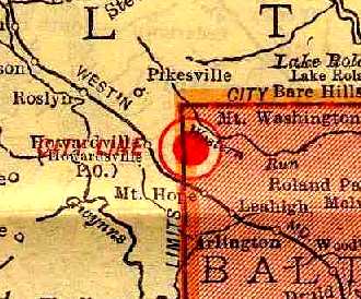
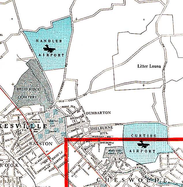
The Park Heights Flying School Airfield (red circle northwest of the center)
and the City Line Airport (red circle southeast of the center),
as depicted on the 1929 "Rand McNally Standard Map of MD with Air Trails" (courtesy of Chris Kennedy).
It described the Park Heights Flying School Airfield as a 72-acre commercial airfield.
Park Heights Flying School Airfield, as depicted on the 1929 Washington to New York City Air Navigation Map #3.
According to the book "Maryland Aloft" by Preston, Lanman, and Breilhan, this field was also known as Service Field.
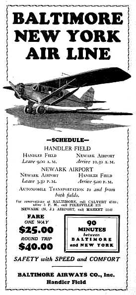
A circa 1929-30 advertisement for Baltimore Airways Company described flights from Handler Field to Newark NJ.
A circa 1930 Cram's street map (courtesy of Greg Stec) depicted “Handler Airport” at this location.
The 1930 Commerce Department Airway Bulletin (courtesy of Michael McMurtrey) depicted the airfield at Park Heights
as consisting of a single 2,000' x 300' grass runway, oriented northwest/southeast.
The airport property was a total of 72 acres, with a single hangar located at the south end, along Park Heights Avenue.
The Bulletin included the remark, "Those landing on Park Heights Flying Field for the first time should use northern half of field.
South of trees in center of field are knolls & depressions with which pilot should be familiar."
The 1931 Commerce Department Descriptions of Airports & Landing Fields (courtesy of David Brooks)
described “Service Field” as a commercial field located 6 miles northwest of Baltimore & 1 mile northwest of Curtiss-Wright Field.
Service Field was described as being a irregularly-shaped 46 acre turf field having 2 runways, the longest being the 2,205' north/south strip.
A 5/28/31 photo (courtesy of Mike Hull) of the members of Park Heights' Baltimore Aero Club.
It was depicted as "Service" Field on the May 1932 Washington Sectional Chart.
Ray Watson recalled, “In the early 1930s my father took me to all the airports in the area.
I had my first lesson at Handler (Service) Field. About 1933 only the south end of the area shown as Service Field was in operation.
My first lesson was in a Curtiss Robin with an OX 5 engine owned by Doug Ruthvan. He traded it for a Waco.”
The only photos which have been located showing aircraft at Service Field were two circa 1933-34 photos by Ray Watson;
this photo showed Doug Ruthvan in front of his Waco at Service Field.
A circa 1933-34 photo by Ray Watson of an unidentified pilot in front of a German biplane (type undetermined) at Service Field.
The 1934 Commerce Department Descriptions of Airports & Landing Fields (courtesy of David Brooks)
described “Service Field” as a commercial field located 1 mile northwest of Curtiss-Wright Field.
Service Field was described as being a irregularly-shaped turf field having 2 runways,
the longest being the 2,205' north/south strip.
The last aeronautical chart depiction which has been located
of the Park Heights Flying School was on the October 1934 Sectional Aeronautical Chart.
The Park Heights Flying School was apparently closed at some point between 1934-35,
as it was no longer depicted on the August 1935 Sectional Aeronautical Chart
nor listed in the 1936 Commerce Department Descriptions of Airports & Landing Fields (courtesy of David Brooks).
A circa 1937-38 aerial view (from the JScholarship Sheridan Libraries Collection)
showed that the former grass airfield area of the Park Heights Flying School remained clear,
but there was no sign of any recent aviation activity,
and the single hangar depicted on the 1930 diagram at the south end of the field was gone.
Park Heights Flying School was no longer depicted at all on the 1943 or 1946 USGS topo maps.
By the time of a 1957 aerial photo, not a trace appeared to remain of Park Heights Flying School –
it had been covered by a housing development.

As seen in a 2017 aerial view looking northwest, the site of Park Heights Flying School is covered by the Fields of Stevenson, a housing development,
and no trace appears to remain of the airfield.
The Park Heights Flying School site is located on the north corner of Stevenson Road & Park Heights Avenue,
with the Baltimore Beltway along the northern border of the airport site.
____________________________________________________
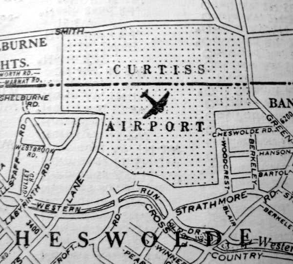
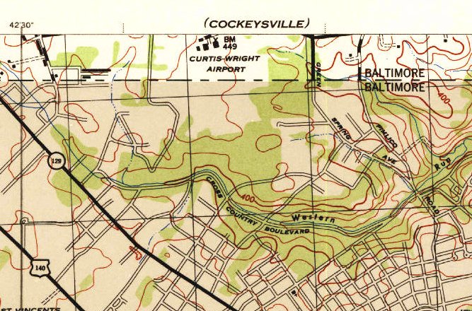
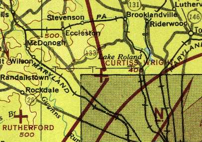
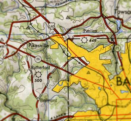
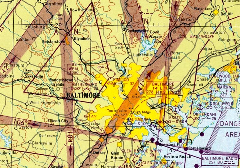
Curtiss-Wright Airport / Pimlico Airport, Baltimore, MD
39.38, -76.69 (Northwest of Downtown Baltimore, MD)
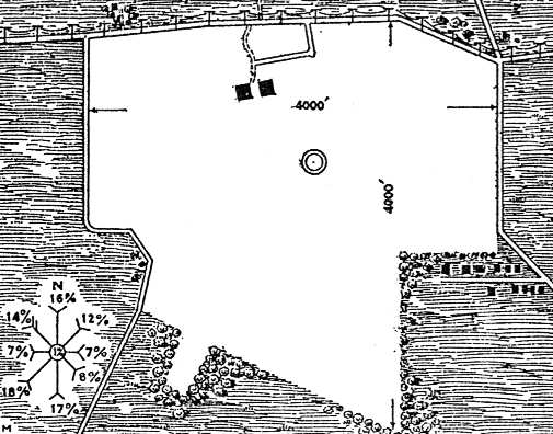
The airfield area at Curtiss Airport, as depicted on a 1930 Commerce Department Airway Bulletin (courtesy of Michael McMurtrey).
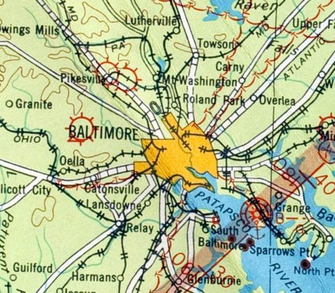
This general aviation airport was located in Baltimore County, just above the Baltimore City line,
southwest of the intersection of Smith Avenue & Greenspring Avenue.
Curtiss-Wright Airport began operations in 1929.
The Curtiss-Wright company got the urge to build airports after Lindbergh created a stir in the public's mind with his Paris flight.
Their field in Baltimore was one of a dozen the company built around the country.
The hangars in particular were distinctively a Curtiss-Wright innovation.
According to the book "Maryland Aloft" by Preston, Lanman, and Breilhan,
upon the field's completion, it replaced Logan Field as the primary base of the local Curtiss-Wright Flying Service.
Curtiss-Wright Airport was described as the "Million Dollar Airport",
and it "offered instruction for pilots & mechanics, maintenance, flight services, and basing for private aircraft."
As depicted on a 1930 Commerce Department Airway Bulletin (courtesy of Michael McMurtrey),
the airfield consisted of a total of 260 acres, with a 4,000' x 4,000' irregularly-shaped grass landing area.
Two 100' x 120' hangars sat at the north end of the field.
The owner was listed as Baltimore Air Terminals, Inc. (with a New York address, ironically!),
and the operator was listed as Curtiss Airports Corporation.
The Flying Club of Baltimore was listed as using the field.
ed from scrapbook of newspaper clippings donated to the Massey Air Museum:
A circa 1930 Cram's street map (courtesy of Greg Stec) depicted “Curtiss Airport”.
Bill Dougherty of the Massey Air Museum reported, “Charles Thompson... was the manager of Curtiss-Wright Airport from approximately 1930 into the 1940s.
The airport sponsored numerous events including parachuting height records.”
The 1931 Commerce Department Descriptions of Airports & Landing Fields (courtesy of Jim David Brooks)
described Curtiss-Wright Airport as an irregularly-shaped 240 acre sod field having 4 runways,
the longest being the 3,000' east/west strip.
Ray Watson reported, “I recall 2 passenger biplanes stationed at Curtiss Wright Airport that were involved in commercial service.”
A 1931 ticket stub (courtesy of Richard Black) for his flight from Curtiss Wright Airport.
Richard Black recalled, “Curtiss Wright Airfield... my brother & I hitchhiked from Baltimore to the airport in the 1930s,
and we always hoped someone would offer us a ride - which never happened.
I had a stub for a plane ride ticket. For age was filled in '7'.
I recall very little about what happened, except my mother had taken me to the airport, and for a plane ride.
The airplane was a twin-engine biplane. There were seats on either side of the center aisle.
Probably single row. The engine covers were held down by spring-handled catches such were used on automobiles at the time.
I was terrified until the airplane left the ground. As I saw the houses pass underneath the plane, I was so impressed, I knew my future would be in aviation.”
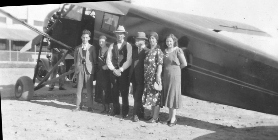
The earliest photo which has been located of Curtss-Wright Field was a Summer 1931 photo by Harry Cassell (courtesy of Don Cassell) of John & Harold Himmer in front of a Curtiss-Wright hangar.
A Summer 1931 photo by Harry Cassell (courtesy of Don Cassell) of a group in front of a Curtiss-Wright Field hangar.
A Summer 1931 photo (from the Harry Cassell collection, courtesy of Don Cassell) of Harold Himmer, Harry Cassell, and John Himmer exiting a Cessna monoplane at Curtiss-Wright Field.
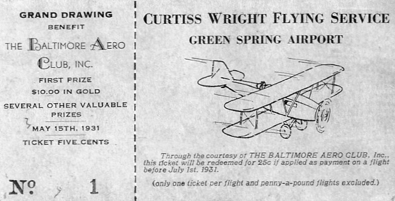
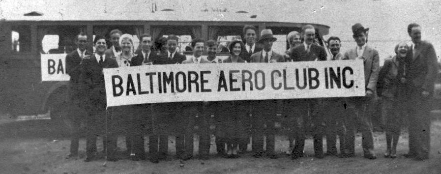
A 1931 ticket (from the Harry Cassell collection, courtesy of Don Cassell) from “Curtiss Wright Flying Service, Green Spring Airport”, to benefit the Baltimore Aero Club.
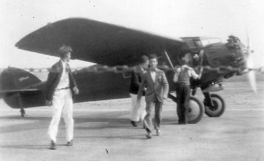
A 10/20/31 photo (from the Harry Cassell collection, courtesy of Don Cassell) of Harry Cassell, Amelia Correa, Alex Moaker, Joseph Benyo, Bessie Benyo, and Hellen Wollen
at Curtiss-Wright Field in front of a Stinson Detroiter 4-place monoplane owned by Alex Moaker of Miami.
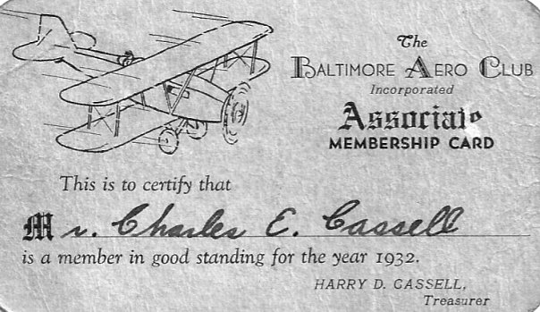
Charles Cassell's Baltimore Aero Club 1932 membership card (from the Harry Cassell collection, courtesy of Don Cassell).
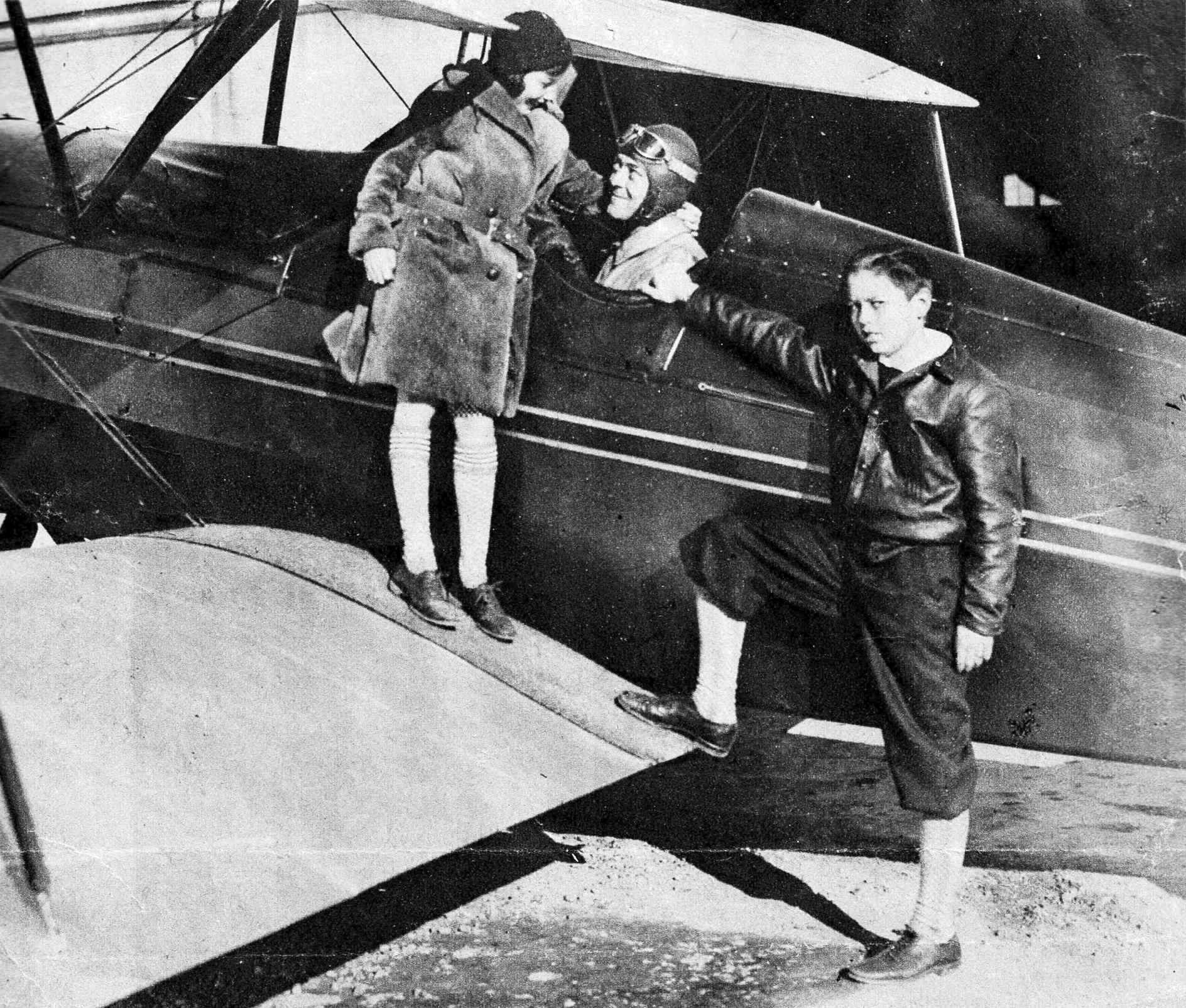
An undated photo published in 1/3/32 of Jean & Charles Thompson Jr. leaving from Curtiss-Wright Field in an unidentified biplane for the All-American Air Races in Miami (from the Charles Thompson collection, courtesy of Bill Dougherty).
Bill Dougherty reported, “Thompson had plans to enter a number of air races & even a transatlantic race from NY to Paris sponsored by the Air Ministry of France in commemoration of the 10th anniversary of Lindbergh’s solo flight.
But the only one he actually went to was 1932 All-American Air Races in Miami.”
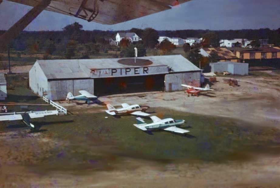
A circa 1930s photo of a Curtiss Condor at Curtiss-Wright Field (from the Charles Thompson collection, courtesy of Bill Dougherty).
A circa 1930s advertisement for Curtiss-Wright Field's Thompson Flying Service (from the Charles Thompson collection, courtesy of Bill Dougherty).
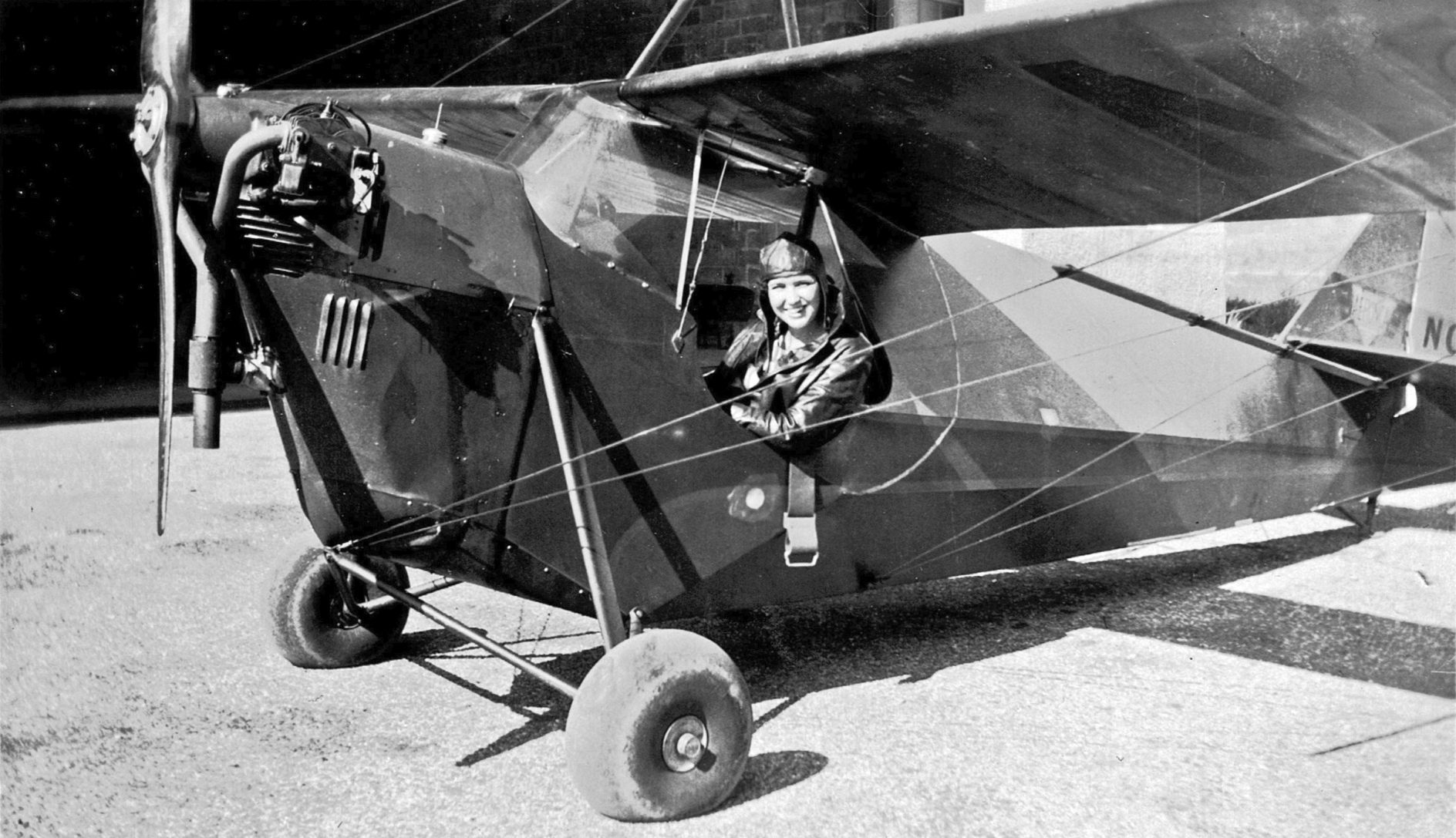
A circa 1930s photo of an unidentified woman in an Aeronca C-2 at Curtiss-Wright Field (from the Charles Thompson collection, courtesy of Bill Dougherty).
Curtiss Wright Field, as depicted on the May 1932 Washington Sectional Chart.
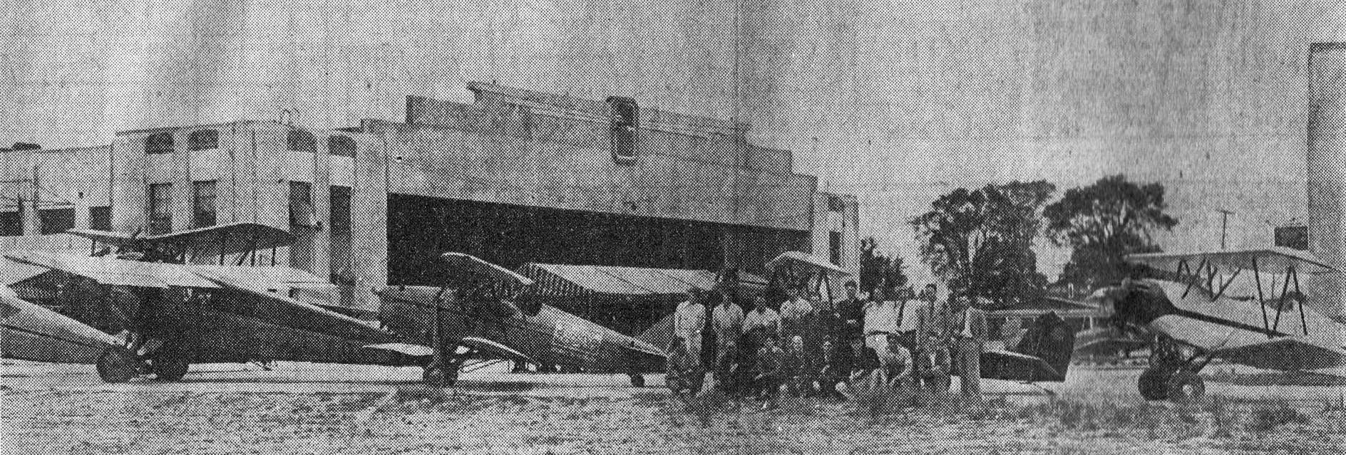
An undated photo from the 6/24/33 Baltimore News of row of biplanes displayed in front of the hangar to celebrate Curtiss-Wright Field's 3rd anniversary (from the Charles Thompson collection, courtesy of Bill Dougherty).
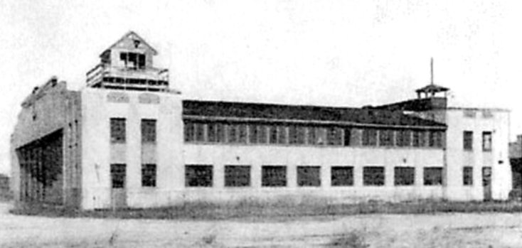
According to the book "Maryland Aloft", Curtiss-Wright Airport was "dominated by 2 imposing concrete-block hangars in the Art-Deco style.
On the airfield side, each hangar had rows of large windows,
set in a single-story projection that was flanked by 2-story sections.
Aerial shows at the field included members of the Thunderbird Flying Club, formed at the airport in 1933.
Behind the excitement at Curtiss-Wright Airport was Colonel William Tipton, who leased & ran the facility during its heyday.
A World War 1 ace pilot, he commanded the Maryland National Guard air unit based at Logan Field,
and was also a flying club president & a columnist on aviation topics.
Curtiss-Wright Airport was an excellent stage for his promotion of air-mindedness;
however it lacked the space to become the air transportation hub he may have envisioned,
and seems not to have been particularly profitable as a business venture."
According to a Baltimore Sun article (via Wade Minami), there was an aerial meet sponsored by the Camber Club held at Curtiss-Wright on 6/3/34, and William Tipton was the event chairman.
The field was located at Smith & Greenspring Avenues.
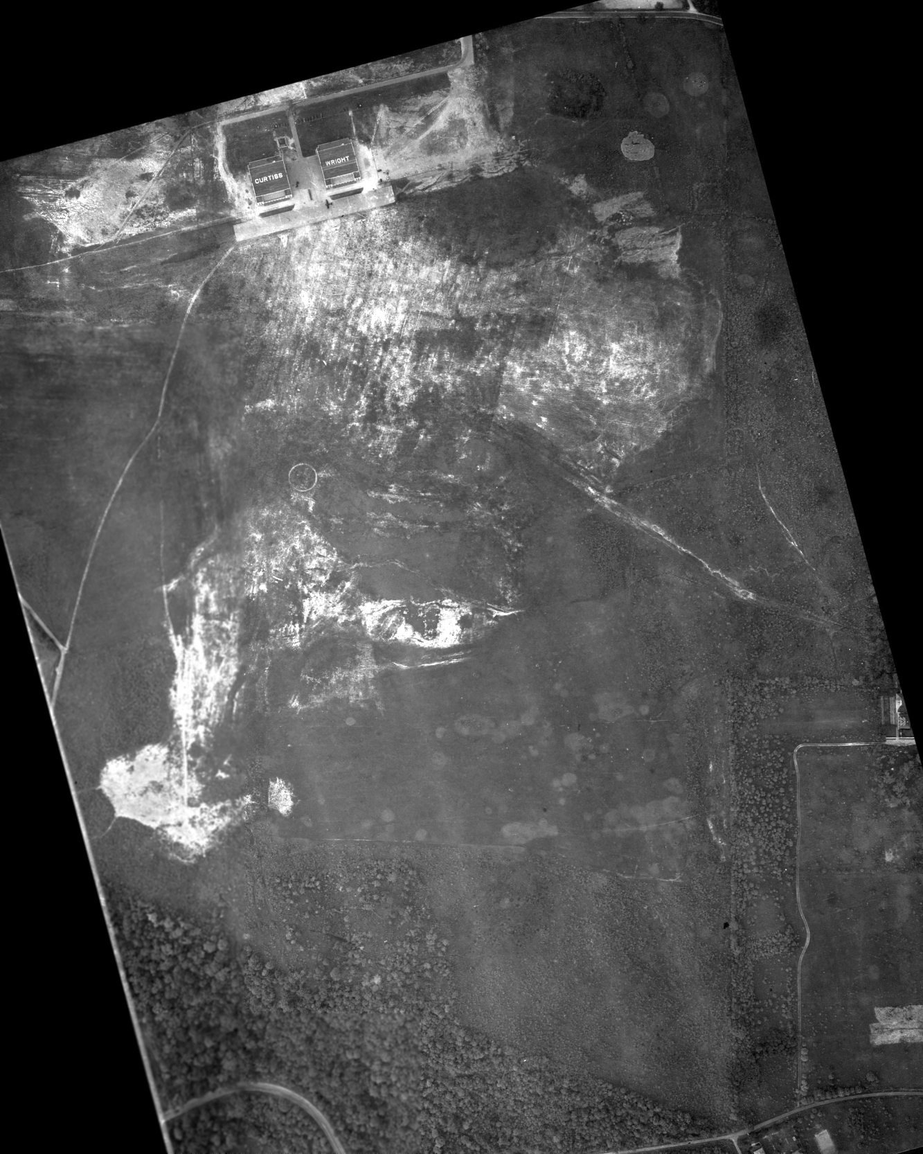
The earliest aerial photo which has been located of Curtss-Wright Field was a 8/12/34 aerial view by the MD National Guard's 104th Observation Squadron (courtesy of Wade Minami).
The airfield consisted of an irregularly-shaped grass area with an airport circle marking in the center.
Two large hangars (painted with “Curtiss” & “Wright”) sat on the north side of the airfield, and 1 single-engine plane was parked on a paved ramp.
According to MD Air National Guard Historian Wade Minami, “Curtiss-Wright Field was operated by William Tipton, a founding member of the MD ANG, in the late 1930s / early 1940s.”
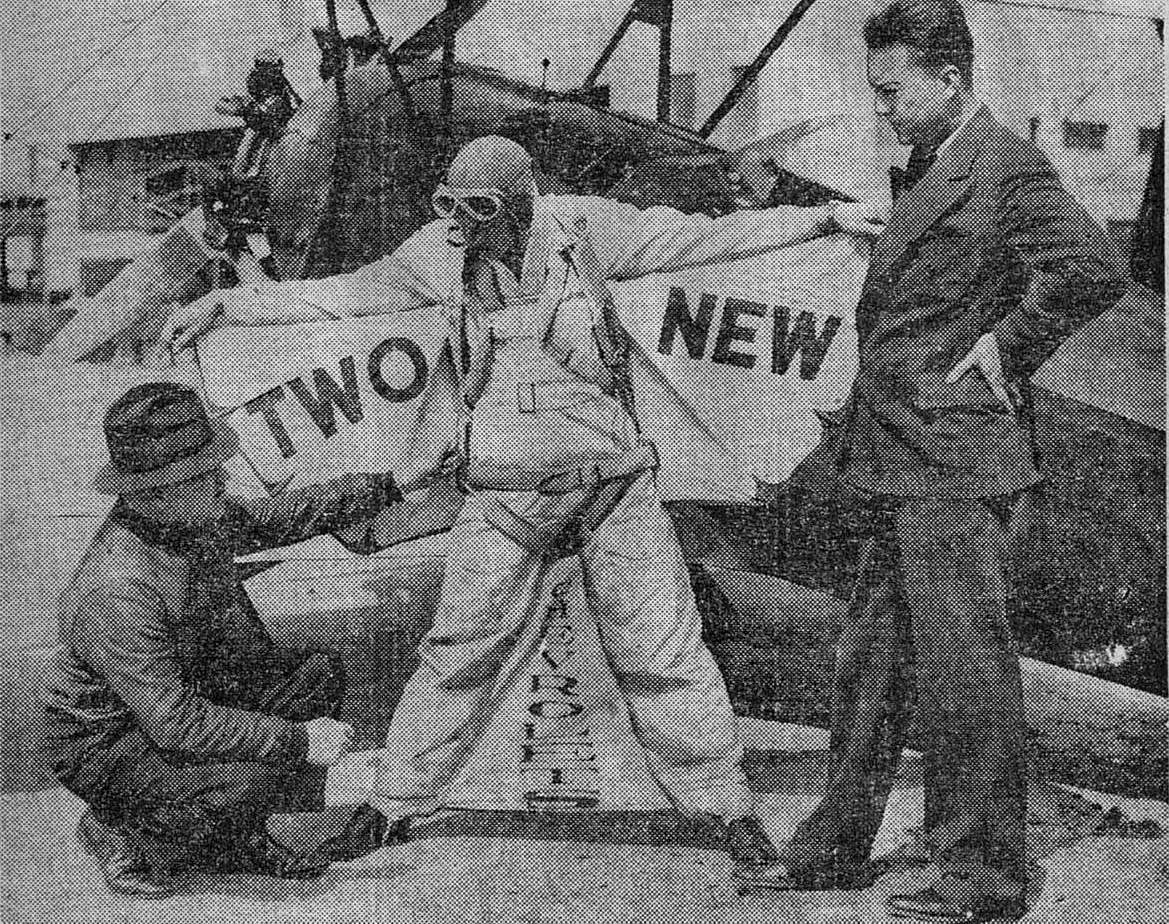
An undated photo from the 4/7/35 Baltimore American of Lt. Col. W.D Tipton & Charles Thompson inspecting Clem Sohn's “fragile-looking Bat Wings” at Curtiss-Wright Field (from the Charles Thompson collection, courtesy of Bill Dougherty).
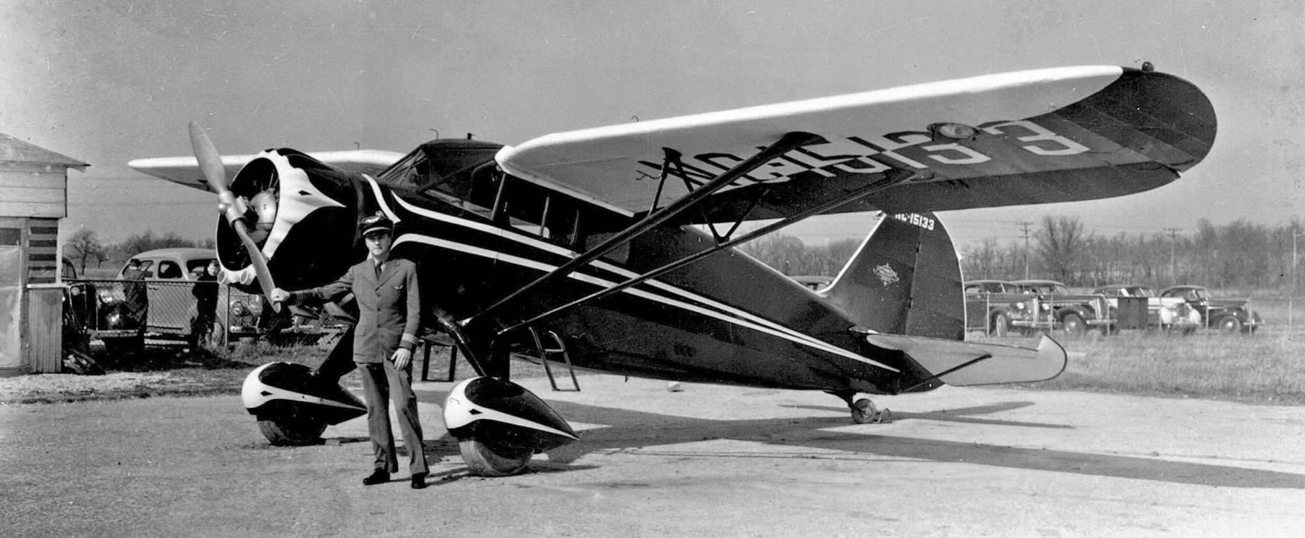
A 1935 photo of an unidentified pilot & Stinson SR-6 N15133 at Curtiss-Wright Field (from the Charles Thompson collection, courtesy of Bill Dougherty).
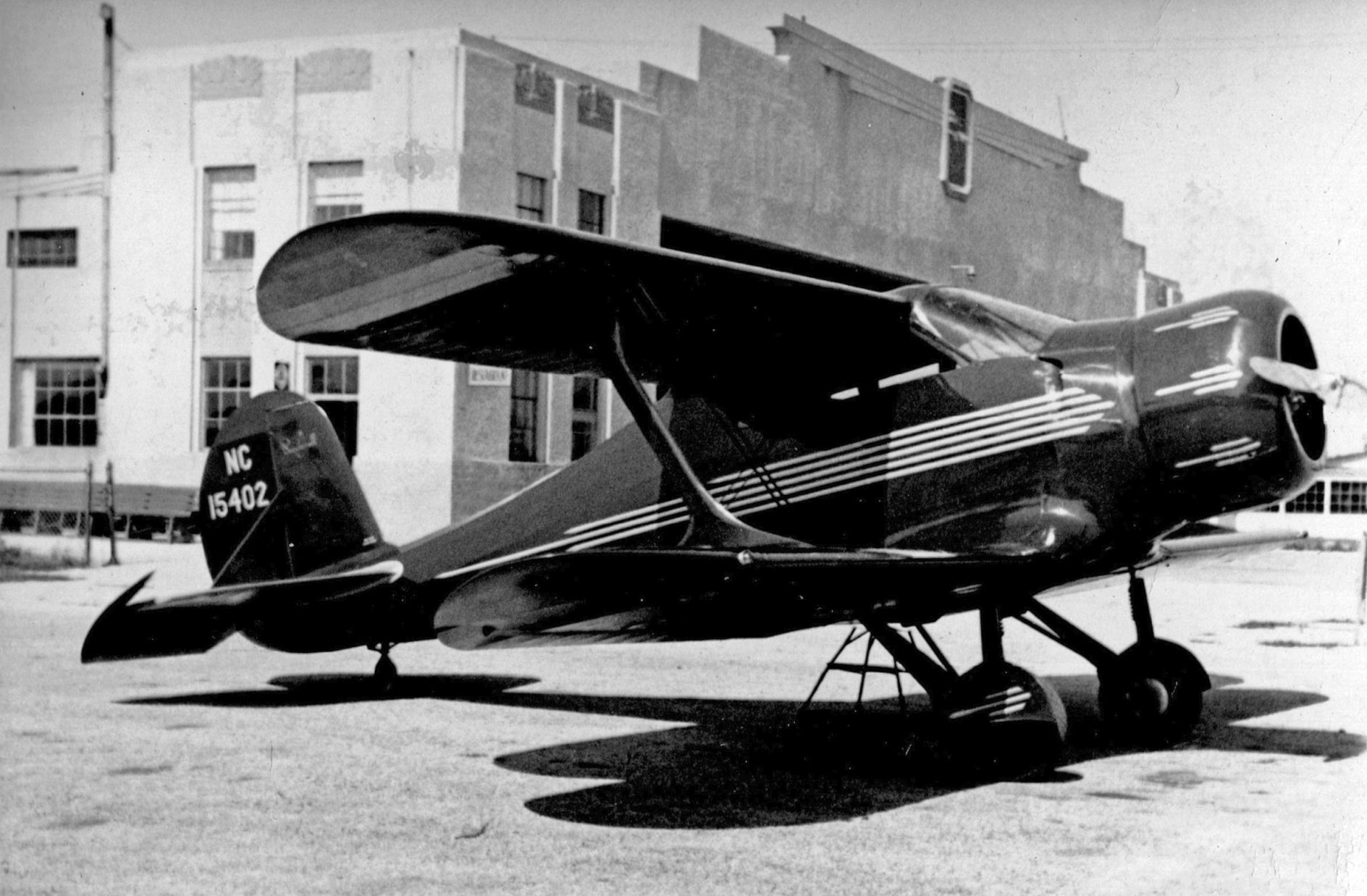
A 1935 photo of beautiful Beech B17L-40 Staggerwing N15402 in front of Curtiss-Wright Field's hangar (from the Charles Thompson collection, courtesy of Bill Dougherty).
Bill Dougherty of the Massey Air Museum reported, “Charles Thompson... bought Stinson Reliant SR-6 N15133 & Staggerwing Beech B17L-40 N15402 in 1935.
Thompson Airways Incorporated was the representative of Airlines Charter Service 'feeding' scheduled air transport companies, at a price of 20 cents / mile.
In the 1930s he frequently flew photographers for the Baltimore newspapers to cover large fires or shipwrecks in the bay,
the stadium over Navy football games, or the arrival of the Pan Am Yankee Clipper based at Baltimore Municipal Airport.”
The 1/1/36 Department of Commerce Airway Bulletin described Curtiss-Wright Airport as a commercial field, consisting of a irregularly-shaped sod field.
It was said to have a total of 4 runways, with the longest being the 3,000' east/west strip.
A hangar was said to be marked with “Curtiss Wright Baltimore” on the roof.
The Airport Directory Company's 1937 Airports Directory (courtesy of Bob Rambo)
described Curtiss-Wright Field as having 3 grass landing strips, with the longest being 3,000'.
The aerial photo in the directory depicted 2 hangars on the field.
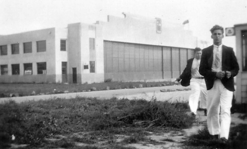
A circa 1937-38 aerial view of Curtiss-Wright Field (from the JScholarship Sheridan Libraries Collection), showing the grass airfield area & the 2 hangars on the north side of the airfield.
No planes were visible on the field.
Curtiss-Wright was Baltimore's largest private flying center by 1941.
Both the field & its school, the Baltimore School of Aeronautics, were in charge of chief pilot Lester Sipe.
According to Av Edidin, “There was talk of making Pimlico the main airport for Baltimore once, with plans to widen Greenspring Avenue to accommodate the traffic.”
At one point Curtiss-Wright had many yellow Piper or Taylorcraft Cubs on the flight line.
According to Joe Handelman, “There was a Kreutzer Air Coach (most likely an K-5) Tri-Motor at the Curtiss-Wright Airport.
The aircraft crashed into a tree off the airport property.”
A circa 1940s street map depicted “Curtiss Airport”.
Curtiss-Wright Field may have been a Civil Air Patrol center during WW2.
According to the book "Maryland Aloft",
"Curtiss-Wright Airport closed, at least for civilian operations, during the war [WW2]."
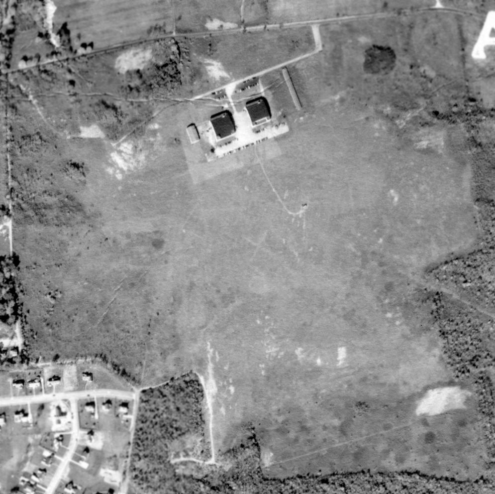
A 9/25/43 aerial view looking northeast at Curtiss-Wright Airport from the 1945 AAF Airfield Directory (courtesy of Scott Murdock)
depicted the field as an open grass area with 2 hangars along the north side.
The directory described Curtiss-Wright Airport as a 260 acre irregularly-shaped field
within which was a sod all-way landing area measuring 3,000' x 2,100'.
The field was said to have 2 hangars: 120' x 100' concrete & steel, and 100' x 50' wood & metal.
The field was described as being privately owned & operated.
The 1944 USGS topo map depicted “Curtis-Wright Airport” [sic] as having 3 hangars, but did not depict any runways.
Curtiss-Wright Airport was still depicted on the 1945 AAF Aeronautical Approach Chart (courtesy of Mike Keefe).
According to the book "Maryland Aloft", the 1946 Haire Publishing Airport Directory indicated that the field was still owned by the Curtiss-Wright Corporation,
and was operated by W. E. Mainville.
Curtiss-Wright Airport was still depicted on 1946 Washington Sectional Chart (courtesy of Mike Keefe).
According to the book "Maryland Aloft", in 1946 "the facility was renamed Pimlico Airport, and presumably changed owners at that time.
Pimlico Airport, as depicted on the 1946 USGS topo map.
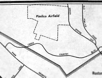
The outline of Pimlico Airfield, as depicted on a 1946 USGS map.
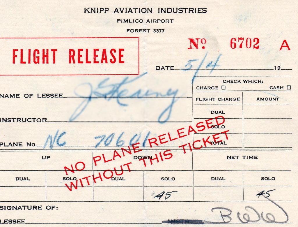
A 5/4/46 receipt for the rental of NC70601 from Pimlico Airport's Knip Aviation Industries (courtesy of Rick Vaeth).
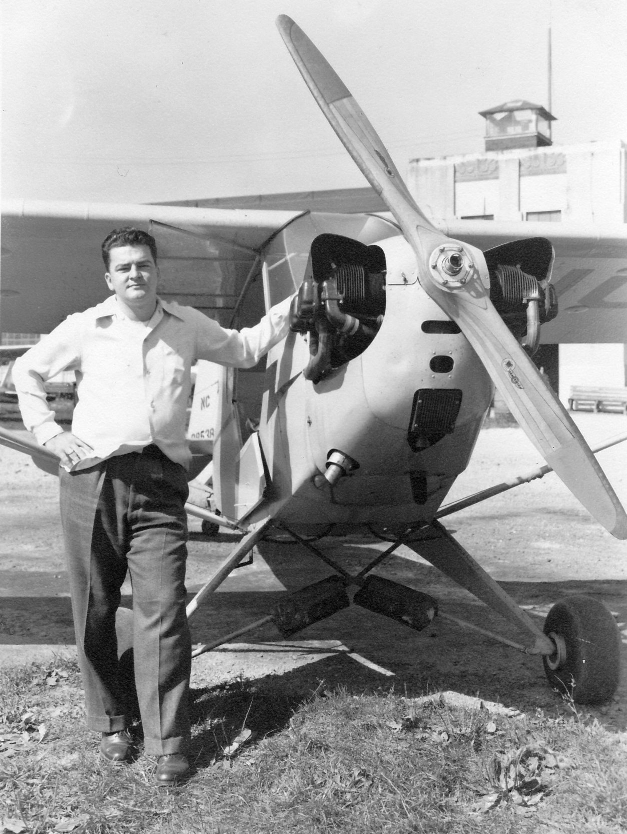
A 10/6/46 photo of pilot James Kearney next to a Piper J-3, with the Pimlico Airport tower visible in the background (courtesy of Rick Vaeth).
A 1947 MD Airport Directory listed Pimlico Airport's owner as Knipp Aviation Industries.
An 8/9/47 photo of Harry Adler & his flight instructor J.M. Robinson in front of a Piper J3 Cub, presumably at Curtiss-Wright Airport (courtesy of Susan Davis).
Susan Davis recalled, “My grandfather, Charles Adler, had an airplane which he flew out of Curtiss Wright Airfield. My father, Harry Adler also flew.
My grandfather was a transportation inventor, and put up the first traffic light in Baltimore as well as inventing the flashing lights on airplanes used for night flying to identify themselves.”
A circa 1940s photo of Alene Adler & a Luscombe, presumably at Curtiss-Wright Airport (courtesy of Susan Davis).
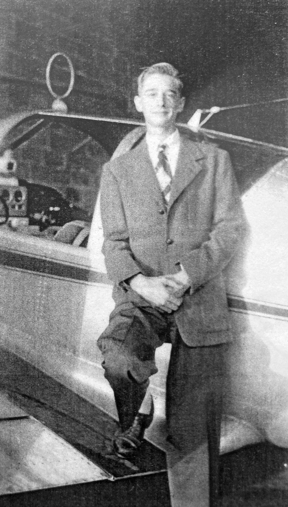
A circa 1940s photo of Harry Adler & a Globe Swift, presumably at Curtiss-Wright Airport (courtesy of Susan Davis).
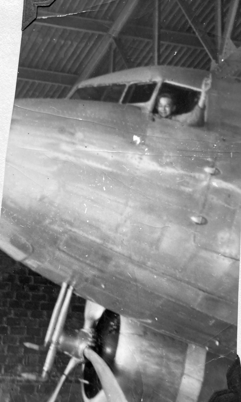
A circa 1940s photo of Harry Adler in the cockpit of a Douglas DC-3, presumably inside the Curtiss-Wright Airport hangar (courtesy of Susan Davis).
The last aeronautical chart depiction which has been located of Pimlico Airport was on the October 1947 Washington Sectional Chart.
It depicted Pimlico Airport as having a 3,200' unpaved runway.
Pimlico Airport evidently closed at some point between 1947-48,
as it was no longer depicted on the April 1948 Washington Sectional Chart.
An article in the 12/12/49 Harness Horse described an effort to build a harness horse racing track on the Pimlico Airport site.
It said “Eugene Beer & his associates lost out in a long effort to build on the site of the old Pimlico Airport,
in the Smith Avenue - Seven Mile Lane area of northern Baltimore.
Residents of the area protested the proposal to establish the track there, and the harness racing group finally decided to locate elsewhere.”
Some time after Pimlico Airport's closing, some war surplus aircraft were stored there.
A silver B-18, possibly a B-23, possibly a B-17, and perhaps a Beech C-45 were parked at one point near the hangars.
Starting in 1951 Bendix Aviation leased 40,000 square feet of Pimlico Airport hangar space for its Field Service operation,
doing radar & electronics work, with radar antennae to be seen from Smith Avenue.
A circa 1951 photo of the Pimlico Airport hangar during the period it was leased by Bendix Aviation for its Field Service operation.
After Bendix left, Pimlico Airport laid abandoned for some years.
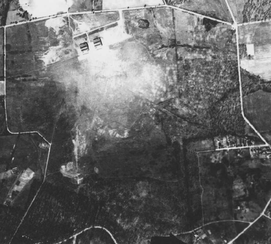
A 10/22/52 aerial view (courtesy of Av Edidin) depicted the abandoned Pimlico Airport as still remaining intact,
with 2 hangars on the north side of the field, and an open grass landing area.
Note that the ramp on the airfield side of the hangars was covered with automobiles, instead of planes.
The 1953 USGS topo map depicted 3 hangars at the site of Curtiss Wright Airport, but did not label the property at all.
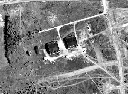
A circa late 1950s aerial view looking west at Curtiss-Wright Airport.
A 3/10/56 aerial view depicted the abandoned Pimlico Airport as still remaining intact, with 2 hangars on the north side of the field, and an open grass landing area.
Similarly to the 1952 picture, the ramp was covered with a large number of automobiles. An oval track had been cut over the former airfield area.
By 1958-1960, Pimlico Airport was a ghost town, with empty hangars.
There was a large wall map of the world in what appeared to have been an operations room.
According to Steve Scheinberg, who lived nearby, "I still remember playing in the empty concrete shells of the hangar.
It had a big wing-looking thing over the entrance."
According to the book "Maryland Aloft", "Photographs published by a local weekly in January 1963 showed that the hangars were still basically intact;
however, the article pointed out that a retail complex was proposed for the property."
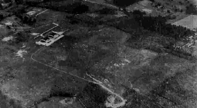
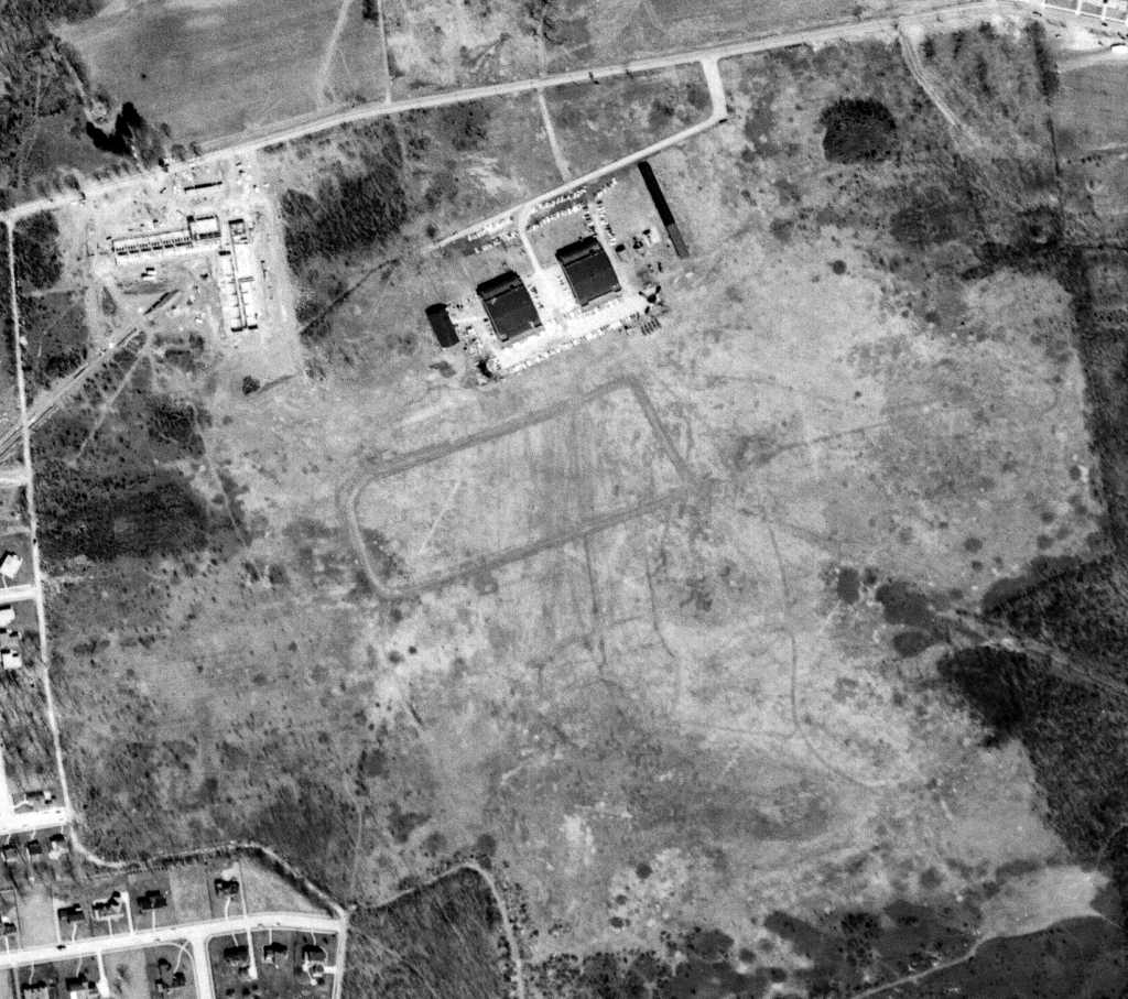
A 1964 aerial view showed that the majority of the Pimlico Airport remained intact,
but housing had been built over a northeastern portion of the property.
A closeup from the 1964 aerial view showing the 2 hangars remaining standing at the abandoned Pimlico Airport.
According to Av Edidin, “My father says that in 1966 there was a professor at Hopkins who would fly his sailplane out of the field after being lofted by whatever sucker he could get to drive a the car tow.”
A 1966 aerial photo showed houses & the Pickwick Apartments had been built over the northern portion of the Pimlico Airport site,
the hangars had been removed, and construction was underway of the Smith Avenue shopping center.
However, some traces of the hangars might have been incorporated into the construction of the new shopping center.
Av Edidin noted, “It looks to me like they re-used & extended the back wall of the hangar, and/or built the new buildings on the pads of the hangars.”
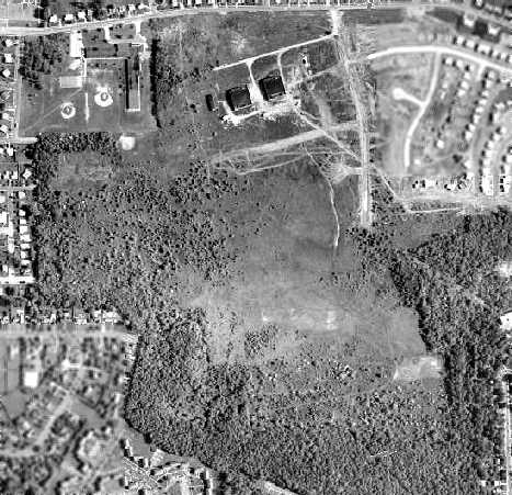
A 1993 aerial photo showed no trace remaining of Pimlico Airport.
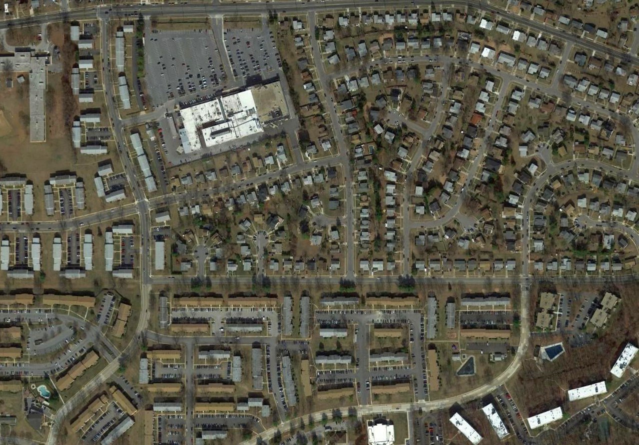
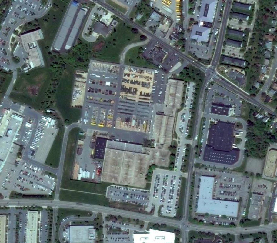
A 2017 aerial view of the site of Curtiss-Wright / Pimlico Airport, showing no remaining trace of the airfield.
Thanks to Joe Handelman for providing details about Curtiss-Wright.
See also:
Baltimore Magazine, 11/1941.
http://www.geocities.com/cd19/curtiss.html
____________________________________________________
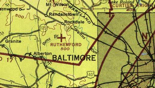
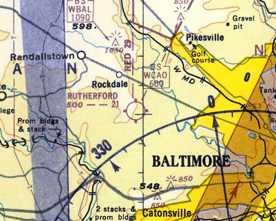
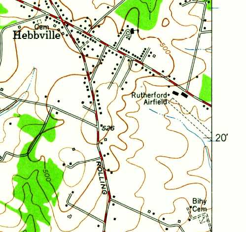
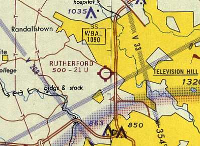
Rutherford Field / Baltimore Airport, Woodlawn, MD
39.336, -76.753 (West of Baltimore, MD)
Rutherford Field, as depicted on the 1929 Washington to New York City Air Navigation Map #3.
According to the book "Maryland Aloft" by Preston, Lanman, and Breilhan,
Rutherford Field "was established in 1929 by Oliver Rutherford, proprietor of a nearby gun & recreation club.
Rutherford's company operated 3 aircraft & offered pilot training, rides, and aerial tours.
Alan Rutherford recalled, “My grandfather was Oliver Rutherford, who I grew up believing owned Rutherford Field, although that might have been an oversimplification.”
Rutherford Field was incorporated in November 1929 on 135 acres of land,
and began operation on 5/1/30, according to the November 1941 issue of Baltimore Magazine.
Michael Turk reported that his great-grandfather, O.B. Rutherford,
owned the land of Rutherford Field (or was the major stockholder in the corporation).
The earliest depiction of Rutherford Field which has been located
was on the 1929 Washington to New York City Air Navigation Map #3.
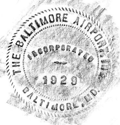
A 1929 seal for “The Baltimore Airport, Inc.” (courtesy of Kristin Shaffer, who found it as she was cleaning out her uncle's basement).
My great-grandfather (Chester Jennings Sr.) was an investor in the Airport.
My grandfather (Chester Jenning Jr.) owned a small plane after WWII,which he kept at the airport.
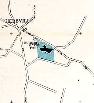
A circa 1930 Cram's street map (courtesy of Greg Stec) depicted “Rutherford Flying Field”.
The 1931 Commerce Department Descriptions of Airports & Landing Fields (courtesy of David Brooks)
described Rutherford Field as an irregularly-shaped 125-acre sod field measuring 2,250' x 1,875'.
The earliest aeronautical chart depiction of Rutherford Field which has been located was on the May 1932 Washington Sectional Chart.
A 1933 directory listed Rutherforld Field's operator as The Baltimore Airport, Inc.,
however the hangar roof displayed the more modest designation of 'Rutherford Field'."
The 1934 Department of Commerce Airport Directory (according to Chris Kennedy)
described "Baltimore Airport (Rutherford Field)" as having an irregularly-shaped 2,250' x 1,875' sod landing area.
Ray Watson recalled, “I hung around Rutherford field after Service Field closed”, [circa 1934-35].
The earliest photo which has been located of Rutherford Field was an undated aerial view looking south from the Airport Directory Company's 1937 Airports Directory (courtesy of Bob Rambo).
The directory described Rutherford Field as having a 100 acre all-way landing area.
The aerial photo in the directory depicted 2 hangars next to the field, one of which had "Baltimore Airport" painted on the roof.
The Airport Directory Company's 1938 Airport Directory (courtesy of David Brooks) described Rutherford as a commercial airport,
consisting of an irregularly-shaped 100 acre sod field.
Steve Hurtt was told "that Howard Hughes flew in to Rutherford in the 1930s with one of the prototype DC-1s."
Charlie Macgill recalled, “Rutherford Field, where I made my first solo in 1940.
As a school boy riding the bus past those red & silver Wacos lined up in front of the hangars, I knew that it was meant to be that I should FLY!
In 1940, after I got my first job, I signed up with Johnny Hinson's Flying School
and met my hero, Bill Tyler, who was to be my instructor.
Bill used to snap roll a J-3 Cub which was a no-no due to the possibility of the tail coming off... but it never did.
One of the best acrobatic pilots who I have ever known... Eddy Waderman. That guy could make a plane talk!”
Rutherford Field was operated by John Hinson from 1940 until the start of WW2, according to an article by Clayton Davis.
A 9/25/43 aerial view looking northeast at Rutherford Airport from the 1945 AAF Airfield Directory (courtesy of Scott Murdock)
depicted the field as an open grass area with hangars along the north side.
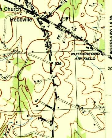
The 1944 USGS topo map labeled “Rutherford Air Field” but did not depict any other details.
The 1945 AAF Airfield Directory (courtesy of Scott Murdock) described Rutherford Airport as a 130 acre irregularly-shaped field
within which were 3 sod runways, with the longest being the 2,250' northeast/southwest strip.
The field was said to have 2 hangars: 120' x 60' & 110' x 60', both being wood & steel.
The field was described as being privately owned & operated.
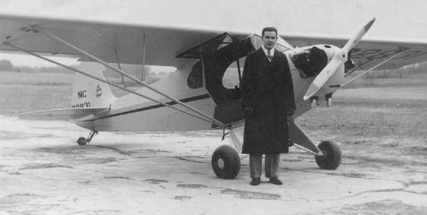
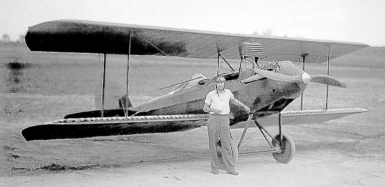
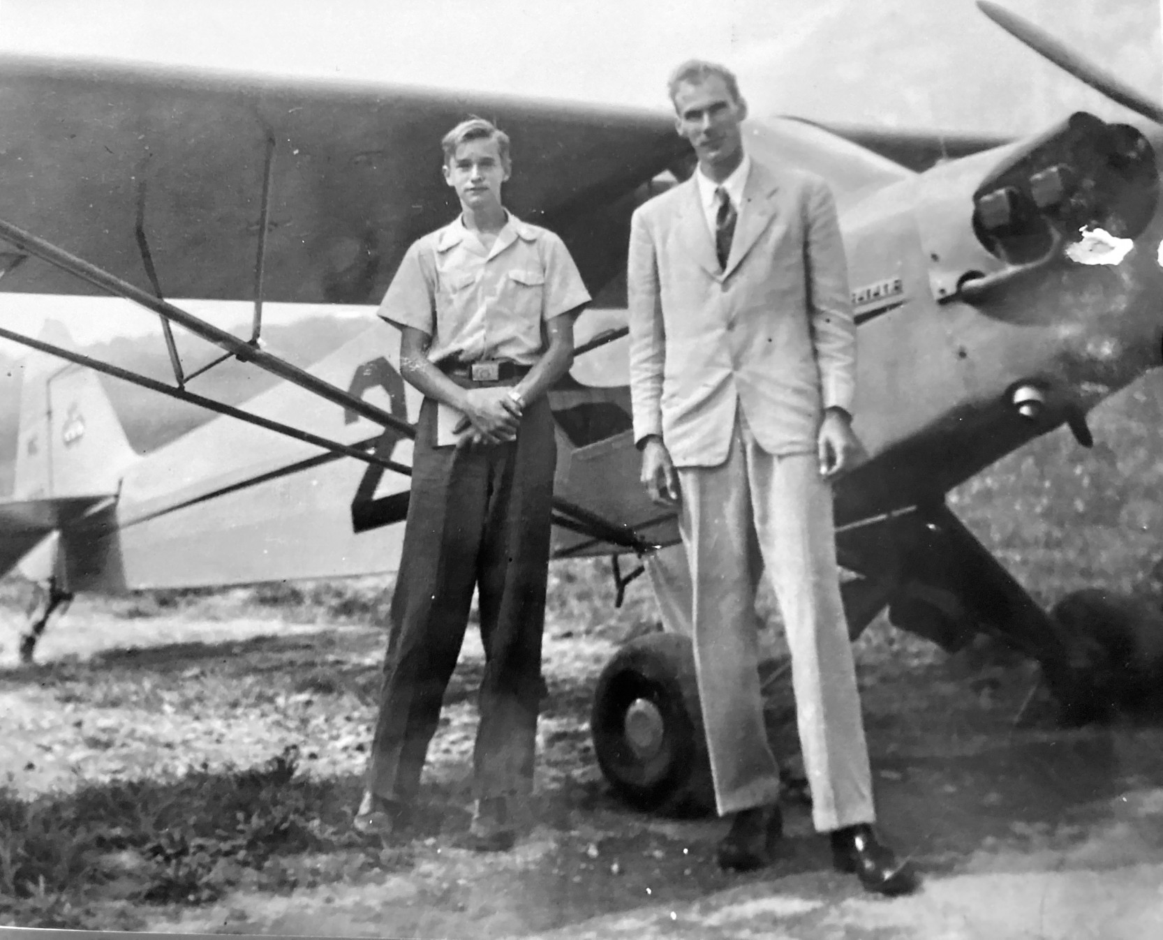
Howard L. Stevens, pictured in 1945 at Rutherford Field in front of a Piper Cub (courtesy of Howard Stevens).
According to Howard Stevens, his father, Howard L. Stevens, operated a flight school at Rutherford Field, under the name of Stevens Flying Service.
"I went through his scrapbook & found newspaper articles about his flight school in Baltimore,
(Rutherford Field) which he had opened & operated when he was about 20 years old [circa 1938]."
Howard L. Stevens later went on to establish & operate Stevens Airport, in Frederick.
Rutherford Field, as depicted on the 1945 AAF Aeronautical Approach Chart (courtesy of Mike Keefe).
According to "Maryland Aloft", a 1946 MD Airport Directory described Rutherford Field as having 4 runways,
with the longest being a 2,100' northeast/southwest strip.
The airport had 2 hangars & a building containing an office & a lounge. The manager was listed as Raymond McNemar.
John Kibler recalled, “My dad, Matthew Kibler, and his friends flew out of Rutherford. My dad had a P-36 there; PT-19s too.
Along with Clyde Vick, Ed Wiederman (best aerobatic ever), Johnny Foyle, and others.”
Rutherford Field, as depicted on the 1946 USGS topo map.
Julian Cottrell recalled, "If you needed a Piper part, if the Pailles' at Davis Field in Laytonsville didn't have it, Mrs. Mack at Rutherford did.
In fact the first time I flew into Rutherford I almost landed on the taxi strip
as it looked much more like the runway than the real runway."
Art Downs recalled, “As a child in the late 1940s, and a resident of West Baltimore,
the field was within walking distance when my dad & I took some very long walks.
He had gone to work in the aviation industry as a young man, briefly at a forgotten company called Berliner-Joyce
and soon thereafter for the Glenn L. Martin Company.
Despite this, he was not that interested in flying.
He & a friend had built a Heath Parasol that they sold to a teacher at McDonough School & the plane & pilot did not last that long.
I do remember walking to the field one day & being impressed by a biplane, probably a Stearman.”
George Phillips recalled, “I grew up, having moved there in 1949,
just on the other side of the Mackin Farm, which was to the west of the airport,
and spent most all my childhood playing in the fields & streams around the runways.
William (grandfather) and George Phillips (father) were lifelong visitors to the Windsor Inn & friends to most all the old flyers there.
When the old Windsor Inn burned down in the 1950s,
us kids salvaged a good supply of tobacco, booze, and naughty books that would have made our mothers faint.
I was always sad to see such a wonderful airport go.
Propeller caps from abandoned & crashed planes that were kept in the old barn which was along the dirt road to the west,
served us kids as pointy medieval helmets.
Our home on 2 Rollwin Road was exactly under the path of planes taking off.
As a tiny guy, the noise would frighten me to crying, but soon that droning of the propellers came to be, and still is,
one of the most beautiful sounds one could ever hear.”
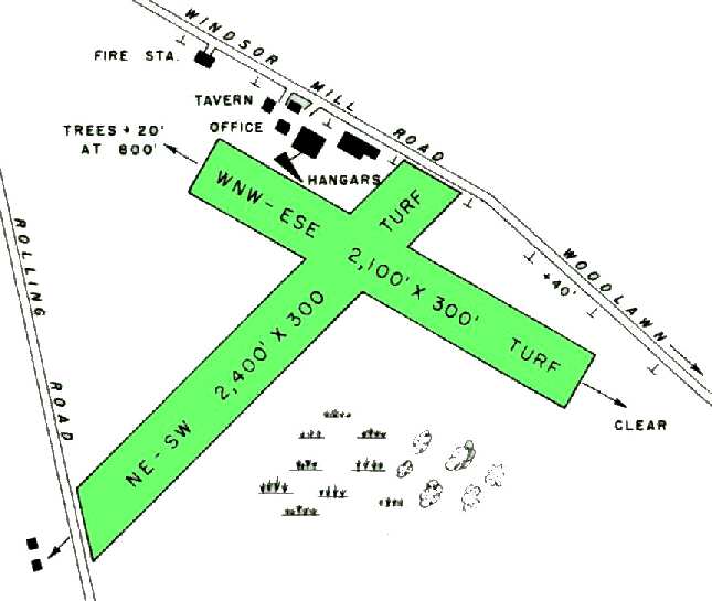
The 1950 MD Airport Directory (courtesy of Stephen Mahaley) described Rutherford Field as having 2 turf runways: northeast/southwest 2,400' & west-northwest/east-southeast 2,100'.
The airport office & at least 3 hangars were located along Windsor Mill Road, north of the runway intersection.
The operator was listed as United Flying Service, and the manager was still listed as Raymond McNemar.
The January 1951 Washington Local Aeronautical Chart (courtesy of Tim Zukas) depicted Rutherford Field as having a 2,100' unpaved runway.
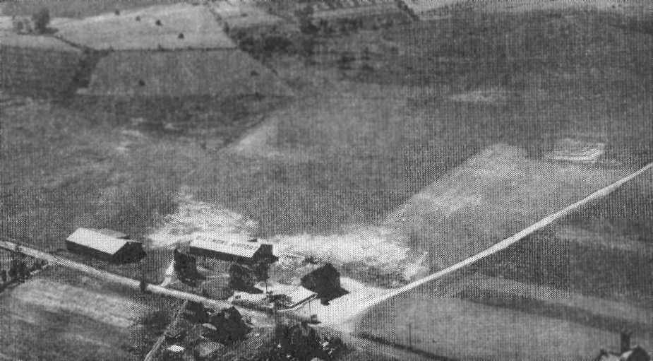
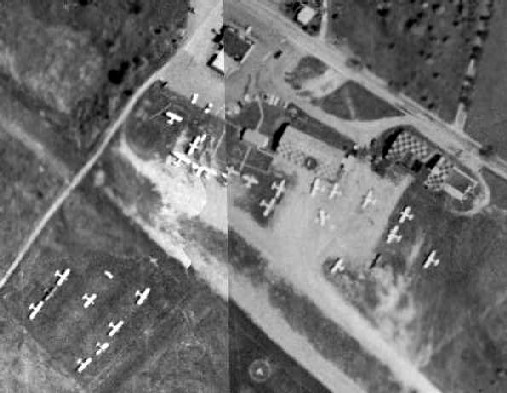
An 8/26/52 aerial view of Rutherford Field (from the JScholarship Sheridan Libraries Collection, via George Phillips),
showing the 2 runways, 2 checkerboard-roofed hangars, and at least 8 light single-engine aircraft.
The 1953 USGS topo map depicted “Rutherford Airfield” as having a single unpaved northwest/southeast runway, with several buildings on the northwest side of the field.
Rutherford Field was historic in that it was the birthplace of the Aviation Branch of the Maryland State Police.
Their first aircraft was a Stinson L-5, which was based at Rutherford Field
after being donated in 1954 by the Turnbull Enterprises Company (according to MD State Police Sgt Don Teesdale).
Rutherford was the closest airport to the State Police's headquarters, in nearby Pikesville.
Brooks Walker recalled, “I went for my first airplane ride at Rutherford in 1954
as well as numerous other times in the 1950s in a plane belonging to my next door neighbor.”
A circa 1955 photo pf Milton Berg in front of his Piper J3 Cub at Rutherford Field (courtesy of Craig Berg).
Craig Berg recalled, “In the mid-1950s, Dad & I were watching planes coming & going from Rutherford Field.
One single-engine plane seemed to be doing a fly-by as it was about half way past the runway & maybe 30' above it.
But suddenly it dropped down & hit the runway very hard; it bounced up & lurched forward; it hit down again & bounced up & forward.
On the 3rd hit the tail end hit first, propelling the plane into a nose-dive. It crashed into a low mound maybe 35 yards past the end of the runway.
My dad was the first one to reach the plane & its pilot. Dad later told me, 'Death took a holiday!'
The woman pilot, on her first ever solo flight, suffered a small cut on her nose. The brand new plane was totaled.
Dad helped her out of what was left of the plane. He had been wearing short pants. To get to the plane he ran through a lot of poison ivy. He suffered the consequences.”
Craig continued, “Tom Gastall, a 24-year-old reserve catcher for the Baltimore Orioles, kept his Ercoupe at Rutherford Field.
He once invited my dad to go for a flight with him.”
According to "Maryland Aloft", a 1955 newspaper article "reported that McNemar & his wife had a staff of 10 to help them
with activities that included flight instruction, repairs, and aircraft sales.
The airport was described as increasingly popular with business representatives flying in & out of Baltimore.
The McNemars said that they would like to expand the facility, but noted that adjacent farmland was now priced at residential levels.
This rising land value was probably already a threat to the airport's future, but the tone of the article was highly optimistic."
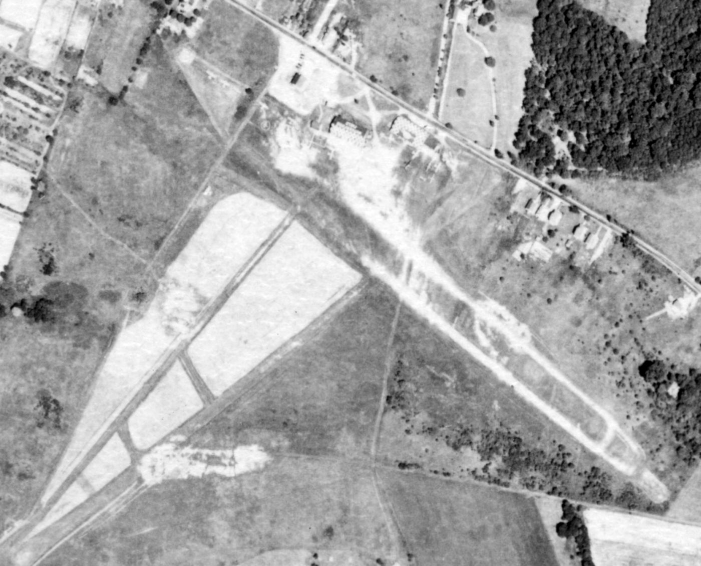
A 1957 aerial view depicted Rutherford Field as having 2 unpaved runways, with several hangars on the north side of the field.
Over a dozen light aircraft were visible parked on the field.
Bob Bloch recalled, “I learned to fly at Rutherford Field in 1958. I had an Aeronca Chief there that I learned to fly in.”
A 1959 photo by Bob Bloch of Howard Bloch & grandfather Sam Bloch alongside their Aeronca at Rutherford Field.
Howard Bloch noted, “I’m grinning like a possum eating a sweet potato.”
Brooks Walker recalled, “I worked at Rutherford Field part time from 1959-63. During that time Rutherford Field was operated by United Flying Service.
At that time Thelma McNamar & her step-son Charles McNamar operated the field.
Thelma was a schoolteacher who married Mr. McNamar senior. I believe he had started the business but had passed away before I arrived on the scene.”
A 1960 photo by Brooks Walker, looking northeast at Rutherford Field.
A circa early 1960s aerial view by Brooks Walker looking northeast at the hangars at Rutherford Field,
after just having taken off to the northwest.
By 1960, the primary runway had apparently lost 300' of its length.
Rutherford was listed among active airports on the 1960 Washington Sectional Aeronautical Chart, with 2 turf runways (the longest being 2,100').
Art Downs recalled, “In 1962, a man I knew who did fly took me up a few times
and let me have my hands on the controls, once in a J-3, the next time in a Tri-Pacer.
Dad never knew & I never bothered to tell him.”
Rutherford Field was listed among active airports in the 1962 AOPA Airport Directory, with the operator listed as United Flying Service Inc.
It was described as having two 2,100' sod runways (5/23 & 15/33, which also had a 1,300' macadam portion).
Brooks Walker recalled, “I joined the Navy early in 1964 & only returned to Rutherford once since then, I think later in 1964.
United Flying Service was still operating the field at that time, and I believe they operated the field until it closed in the late 1960s.”
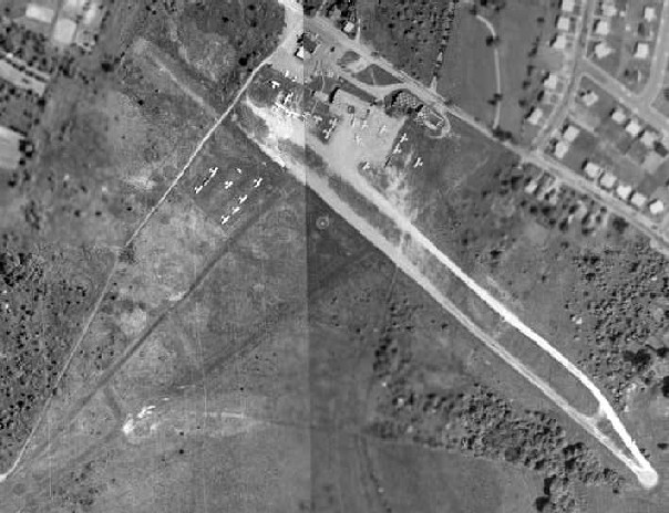
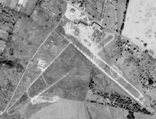
A 1964 aerial view of Rutherford Field, in which the northwest/southeast runway almost appeared to be paved.
The crosswind runway still remained intact, but did not appear to be much-used.
A closeup from the 1964 aerial view, showing Rutherford Field perhaps at it zenith,
with a total of over 25 light aircraft visible parked on the field.
Steve Hurtt recalled "having grown up in Rutherford Heights, the subdivision across Windsor Mill Rd from the airfield.
My family moved out to Windsor Mill Road in the early 1960s
and Rutherford was a neat place to buy a 6 cent, 6 ounce Coke, a Lance cracker, and watch the planes.
As a young lad, the airport was a great hangout & I constantly begged Miss Mack for a job there.
She always told me to come back when I was 16. I did & was hired as a lineboy!
I worked there [starting in] 1964.
Probably the heyday of the field was in 1965, when we had 60 plus planes based at the airport.”
Bruce Bowersock recalled, “I had Richard & Bobbie Green as instructors [at Rutherford Field].
Donald Berger was my flight instructor when I soloed on 4/4/65.”
The 1965 Washington Local Visual Navigation Chart depicted Rutherford Field as having a 2,100' unpaved runway.
Steve Ames recalled, “Rutherford Field... I started taking flying lessons there in 1965,
soloed & was working towards my Private Pilot when they announced that the airport would be closed. That was in 1966 I think.
When I started at Rutherford the rental airplanes were all Pipers: Colts & Tri-Pacers.
The FBO (Mrs. Mack) then moved her operation to Friendship Airport where I finally completed my PPL in 1966 or 67.
I believe that I met Senator Sarbanes at Rutherford (before he was a senator).
I seem to remember that he was in a partnership that owned a Piper Comanche.
At about the time the airport closed, I seem to remember that she went to the newer Piper Cherokees.”
Charlie Wood recalled, “I began my flying at Rutherford on 7/1/65.
I owned a Tripacer, N3343A, which was a joy to fly. I was living in Glen Burnie at the time.
My flight instructor at Rutherford was good, but he hated his job.
I don't think he quite realized that except for the occasional 'let me show you how'
he would be spending all of his hours in the right seat watching.
Shortly after I left Rutherford, he did too, and he went to work in a greasy spoon restaurant.
That was too bad because it takes a lot of work to earn a CFI rating.”
Charlie continued, “I kept my plane in the hangar at Rutherford
which meant I had to call ahead so they could pull it out for me by the time I arrived.
That was seldom easy for them because the aircraft were gloved in there
to get as many as possible inside the protection of the hangar.
That sun was brutal on the fabric covering of aircraft common in those days.
It was the poor line boy of course who extricated the various aircraft from the hangar.”
Charlie continued, “I have many fond memories of Rutherford. I don't recall the main runway orientation, maybe 14/32.
When using Runway 32, the 1st half was paved (macadam) and the 2nd half was gravel.
The whole time I was there, almost a year, I never saw the crosswind runway used. Runway 14/32 offered its own excitement.
On the approach to Runway 32 one had to fly over some power lines, marked with a couple of large orange balls to aid seeing them.
On takeoff there was the usual grove of trees right off the departure end.”
Charlie continued, “I started my training 7/1/65 in the Piper Colt, the 2-passenger version of the Tripacer with a 108 hp engine (and no flaps).
By November of 1965 I wanted the flexibility of my own plane & they had a very nice 1953 Tripacer, 3343A, hangared there & for sale.”
Rutherford was still depicted on the March 1966 Washington Sectional Chart.
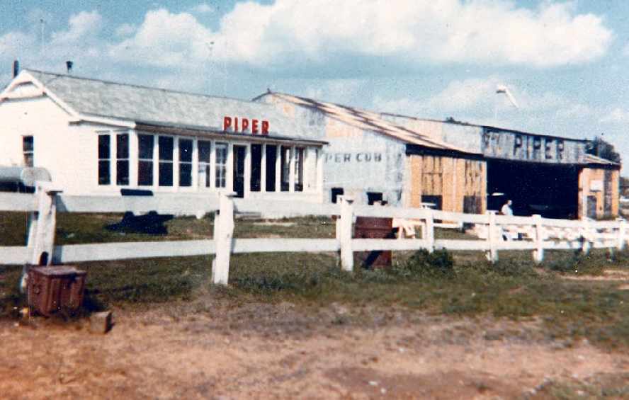
A 1966 photo by Charlie Wood looking northeast at the Rutherford Field office & hangar.
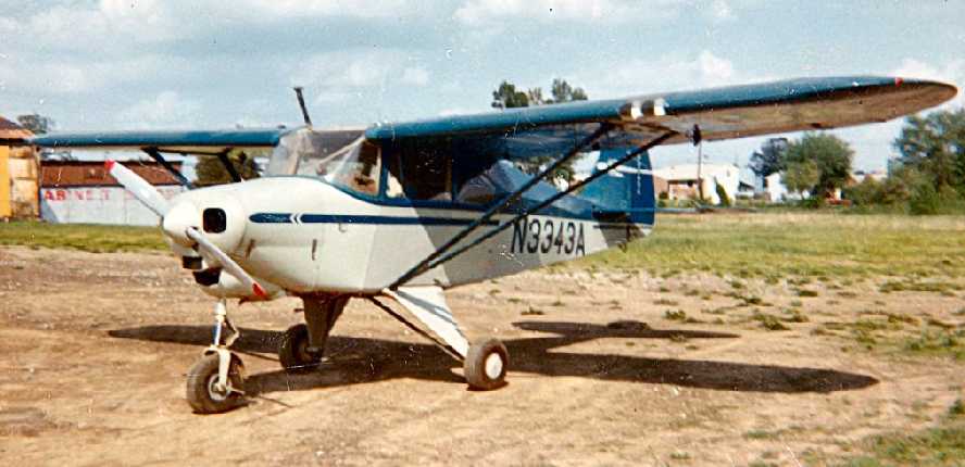
A 1966 photo by Charlie Wood of “my 1953 PA22-135 Tripacer 3343A when it was hangared at Rutherford, before my move to Friendship airport.”
Rutherford was still depicted as an active commercial airfield on the 1966 Washington Visual Navigation Chart (courtesy of Mike Keefe), with a 2,100' unpaved runway.
A 1966 aerial view showed a total of 17 light aircraft parked outside at Rutherford Field, in its last year of operation.
Steve Hurtt recalled the he worked at Rutherford up "to the closing of the airfield in the Spring of 1966.
I was told that the land the airfield sat on was leased & the 40 year lease term was over,
making the opening year of the field 1926."

A 2013 photo by Steve Hurtt of an undated business card for United Flying Service Inc, Rutherford Airport.
Steve recalled, “I was told about the airports demise in the summer of 1966,
I foraged around in the old parts room & found the frame & the business card.”
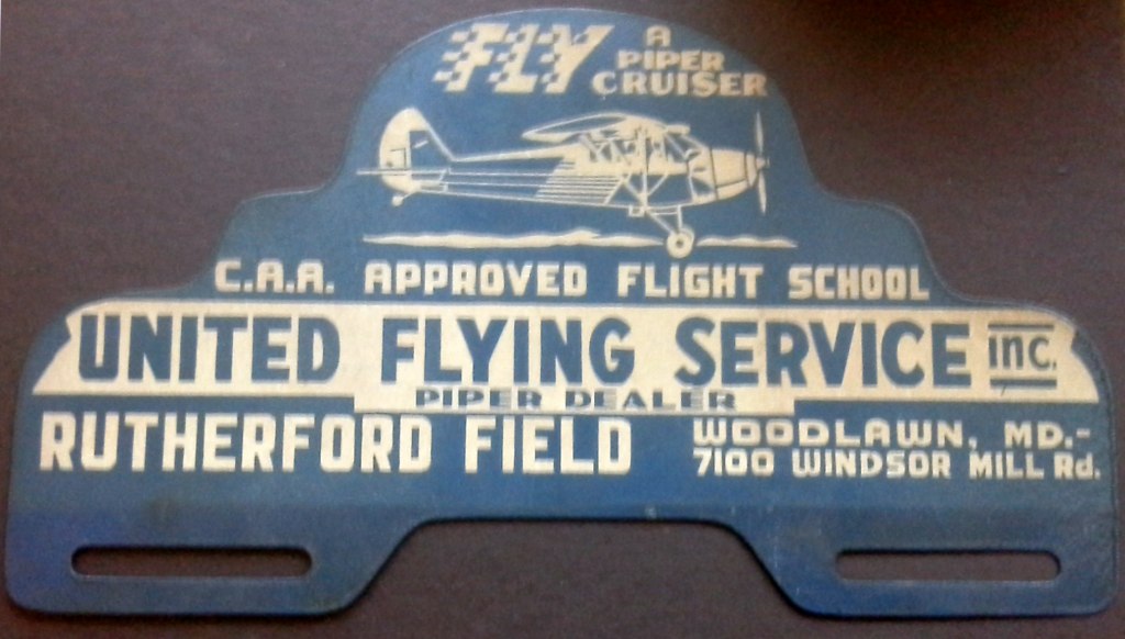
A 2013 photo by Steve Hurtt of an undated license plate frame card for United Flying Service Inc, Rutherford Field.
Steve recalled, “I was told about the airports demise in the summer of 1966,
I foraged around in the old parts room & found the frame & the business card.”
Rutherford was no longer depicted on the October 1966 Washington Sectional Chart.
Michael Turk reported that his great-grandfather, O.B. Rutherford, sold the land of the airport in the mid-1960s to developers.
Unfortunately, two very large developments occurred near this little airport in the 1960s
which probably combined to make the land at Rutherford Field
too valuable to continue to be used as a small general aviation airport.
The Baltimore Beltway was built only a quarter mile east of the field,
and the massive headquarters of the Social Security Administration was built a few miles to the southeast.
Both of these factors boosted land values tremendously in the nearby area,
and undoubtedly hastened Rutherford Field's demise & conversion into more a more densely-built commercial property.
Micheal Dolin recalled, “Rutherford Field... was the first field I landed at in Baltimore.
It was closed when I touched down in the spring of 1967.
In fact it was rumored that the police were watching for airplanes that wouldn't give up the field shortly after it closed.
I must have landed my Taylorcraft long after anyone gave up looking for unauthorized airplanes landing.
I might have flown with an out of date chart then.”
Rutherford Field was no longer listed among active airfields in the 1968 Flight Guide (courtesy of Robert Levittan).
A 1971 aerial photo showed Rutherford Field to be in a state of abandonment,
with all of the planes gone, and trucks (construction vehicles?) parked in their place.
The main hangar still remained, and the runways were still clear,
but one of the buildings along Windsor Mill Road had already been removed.
Lee Hughart recalled of Rutherford Field, “In the 1970s the field was used for a Boy Scout Camporee for the Frontier Council
and a Civil War reenactment was held there.”
David Pipes said, "The land stood vacant until the late 1970s.
At that point, the area began to be developed, and I recall that by 1980 very little open land was left in that area."
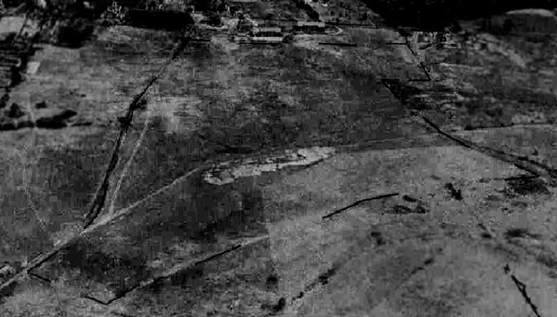
A 1993 aerial photo showed no trace remaining of Rutherford Field.
Art Downs observed, “I felt a strong sense of sorrow when the field was no longer there. Sic transit gloria mundi.”
A 2015 aerial photo shows Rutherford Field lives on in name only, as the Rutherford Business Park, an office park. No trace remains of the airport.
The site of Rutherford Field is located southwest of the intersection of the Baltimore Beltway & Windsor Mill Road.
____________________________________________________
Or if you prefer to contact me directly concerning a contribution (for a mailing address to send a check),
please contact me at: paulandterryfreeman@gmail.com
If you enjoy this web site, please support it with a financial contribution.
____________________________________________________
This site covers airfields in all 50 states.
For the site's main menu: Home