Abandoned & Little-Known Airfields:
Western Nebraska
© 2002, © 2026 by Paul Freeman. Revised 3/15/26.
____________________________________________________
Please consider a financial contribution to support the continued growth & operation of this site.
Harrison Municipal Airport / Skyranch Airport (revised 11/20/23) - McCook AAF (revised 9/4/25) - Sioux Army Depot Airfield / Western Nebraska Technical College Airfield (revised 9/3/16)
Thedford Airport / (Original) Thomas County Airport (revised 1/7/25) - Trenton Municipal Airport (revised 3/15/26)
____________________________________________________
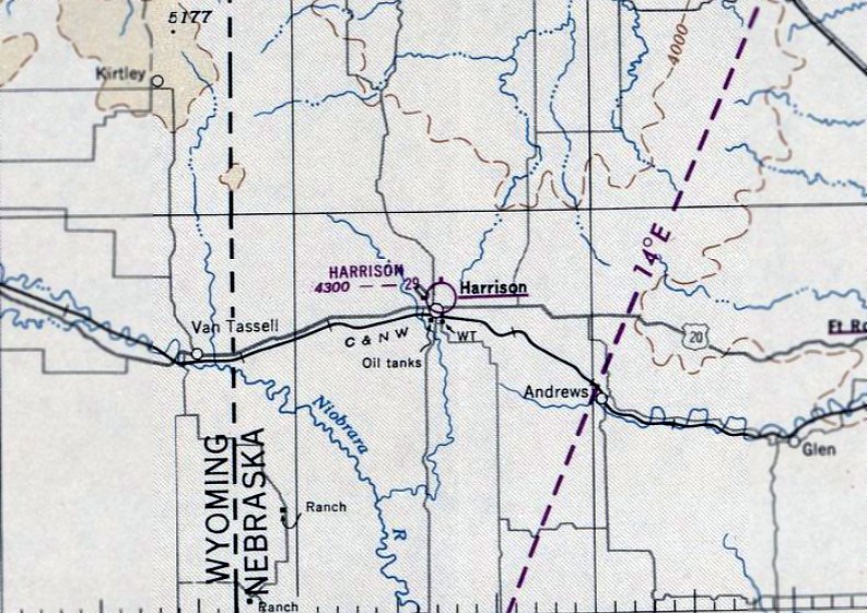
Harrison Municipal Airport / Skyranch Airport, Harrison, NE
42.694, -103.875 (Southwest of Rapid City, SD)
Harrison Airport, as depicted on the October 1949 Casper Sectional Chart.
This small general aviation airport was evidently established at some point in 1949,
as it was not yet depicted on the April 1949 Casper Sectional Chart.
The earliest depiction which has been located of Harrison Airport was on the October 1949 Casper Sectional Chart,
which depicted Harrison Airport as having a 2,900' unpaved runway.
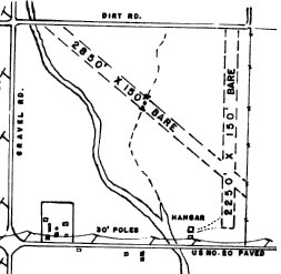
The 1950 NE Airport Directory (courtesy of Lee Corbin) depicted Harrison Municipal Airport as having 2 bare runways, measuring 2,850' northwest/southeast & 2,250' north/south.
A hangar & another small building were depicted on the south side.
The operator was listed as a Bar Q Aircraft, and the manager as R. Quintard.
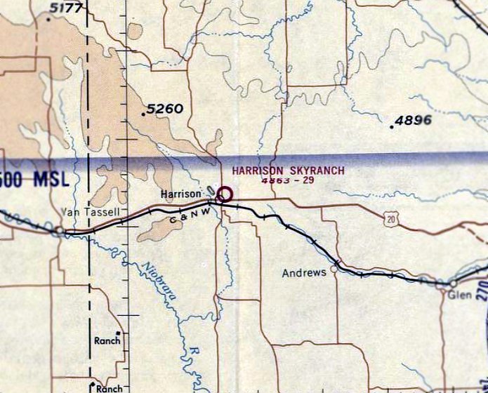
Harrison Municipal Airport was evidently renamed Harrison Skyranch at some point between 1950-70,
as that is how it was labeled on the April 1970 Casper Sectional Chart.
It depicted Harrison Skyranch as having a 2,900' unpaved runway.
The earliest photo which has been located of Harrison Skyranch was a 1973 aerial view,
which depicted a single unpaved northwest/southeast runway.
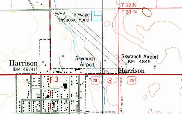
The 1978 USGS topo map (courtesy of Lee Corbin) depicted Skyranch Airport as having 2 unpaved runways, with a few small buildings on the south side.
Skyranch Airport evidently was improved with a paved runway at some point between 1978-93,
as a 1993 USGS aerial view looking northeast (courtesy of Lee Corbin) depicted it as having a paved Runway 12/30,
with a single small Quonset hut building on the south side.
One small single-engine aircraft was visible parked in between the runway & the building.
A 1999 aerial view still showed Skyranch's runway marked as an active runway.
Skyranch Airport was evidently closed (for reasons unknown) at some point between 1999-2003,
as a 2003 aerial view showed the runway pavement had been removed,
and it was no longer depicted on the July 2009 Cheyenne Sectional Chart.
A 2013 aerial view looking northeast at the site of Skyranch Airport showed the former paved runway alignment was still recognizable,
and the airport Quonset hut / hangar remained on the south side.
A 2022 photo looking north showed the former Skyranch Airport beacon light tower & hangar.
Thanks to Lee Corbin for pointing out this airport.
____________________________________________________
Thedford Airport / (Original) Thomas County Airport, Thedford, NE
41.98, -100.532 (West of Lincoln, NE)
Thedford Airport, as depicted on the June 1960 Sioux City Sectional Chart (courtesy of Lee Corbin).
Thedford Airport was evidently established at some point between 1959-60,
as it was not yet depicted on a 1955 aerial photo or the June 1959 Sioux City Sectional Chart.
The earliest depiction which has been located of Thedford Airport was on the June 1960 Sioux City Sectional Chart,
which depicted Thedford as having a 2,800' unpaved runway.

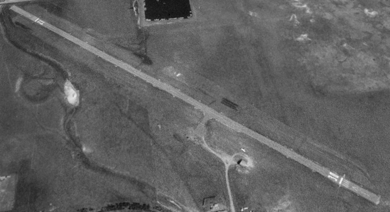
The earliest photo which has been located of Thedford Airport was a 10/9/75 UGSS aerial view.
It depicted Thedford Airport as having an asphalt east/west runway,
with an asphalt taxiway leading to an asphalt ramp & several small buildings on the northeast side.
The 1986 USGS topo map (courtesy of Lee Corbin) depicted Thomas “County Airport” as having a paved east/west runway,
with a paved taxiway leading to a paved ramp & 4 small buildings on the northeast side.
A 1993 USGS aerial view looking southwest depicted Thedford Airport as having paved Runway 8/28, with a paved taxiway leading to a paved ramp & 4 small buildings on the northeast side.
There were no aircraft visible parked outside.
In March 1998 a larger Thomas County Airport was opened 2 miles to the southwest, at which point Thedford Airport was presumably closed.
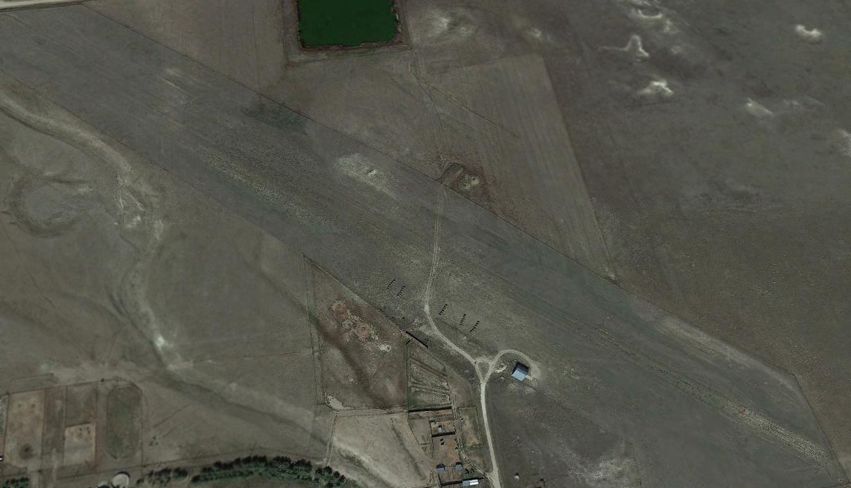
A 2016 aerial view looking southwest at Thedford Airport showed the runway & buildings to remain intact, though deteriorated.
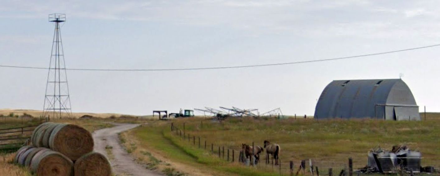
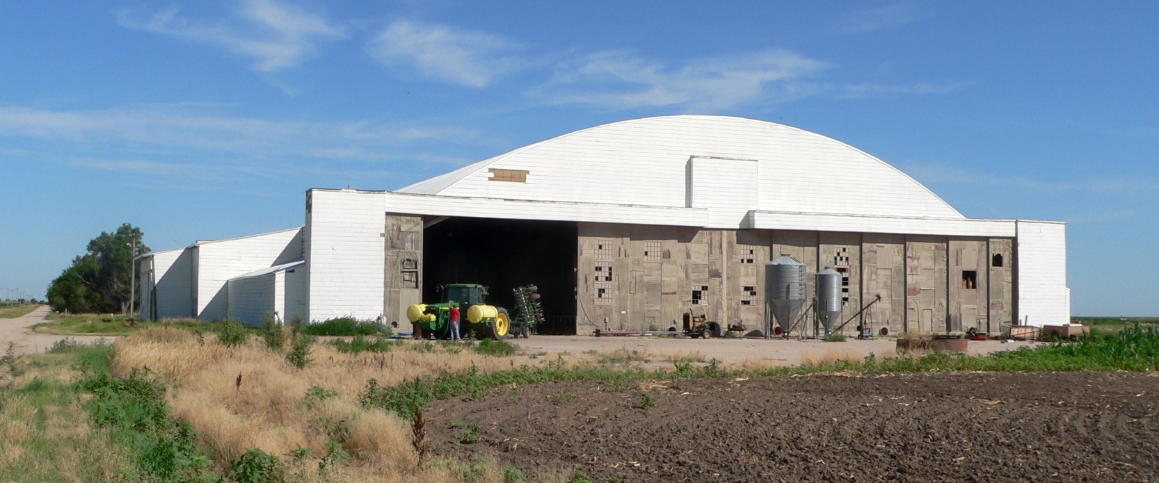
A 2023 photo looking southeast at former Thedford Airport hangars.
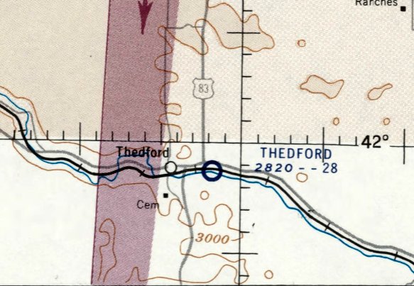
The site of Thedford Airport is located southeast of the intersection of Route 2 & Route 83.
Thanks to Lee Corbin for pointing out this airport.
____________________________________________________
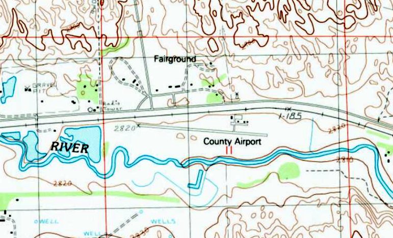
Trenton Municipal Airport (9V2), Trenton, NE
40.19, -101.03 (Northeast of Denver, CO)
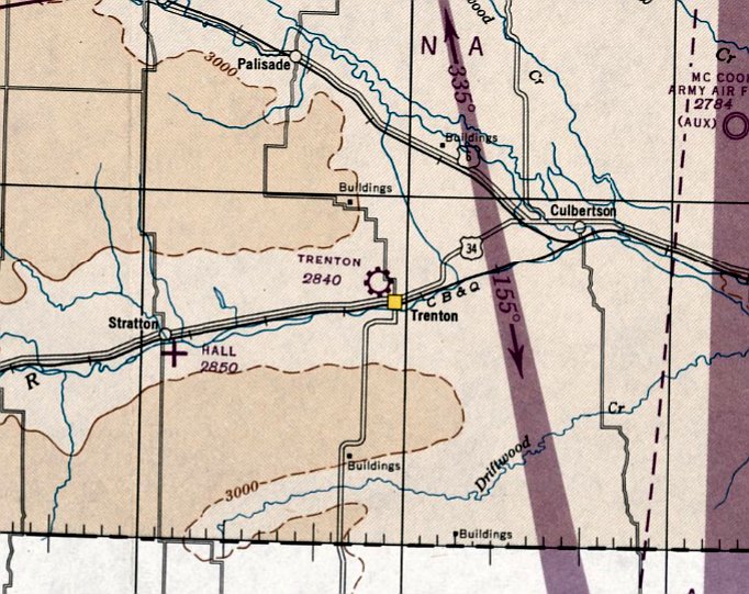
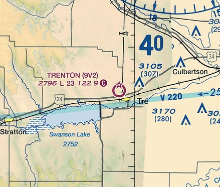
Trenton Municipal Airport, as depicted on the May 1947 Lincoln Sectional Chart.
Yet another one of America's disappearing general aviation airports.
According to its FAA Airport/Facility Directory data, Trenton Municipal Airport was activated in April 1946
(along with hundreds of other airports in the post-WW2 American general aviation boom).
Trenton Municipal Airport was not yet depicted on the December 1946 Lincoln Sectional Chart.
The earliest depiction which has been located of Trenton Municipal Airport was on the May 1947 Lincoln Sectional Chart,
which depicted Trenton as a commercial/municipal airport.
The earliest airport directory depiction which has been located of Trenton Municipal Airport was in the 1950 NE Airport Directory.
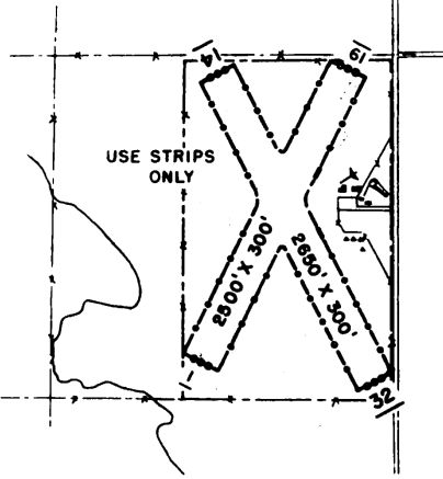
It depicted Trenton as having 2 unpaved runways: 2,650' Runway 14/32 & 2,500' 1/19.
The May 1951 Lincoln Sectional Chart depicted Trenton Municipal Airport as having a 2,700' unpaved runway.
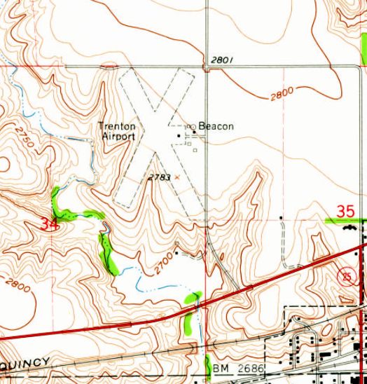
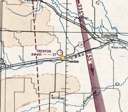
The 1962 USGS topo map depicted Trenton Airport as having 2 unpaved runways, with a few small buildings & a beacon on the east side.
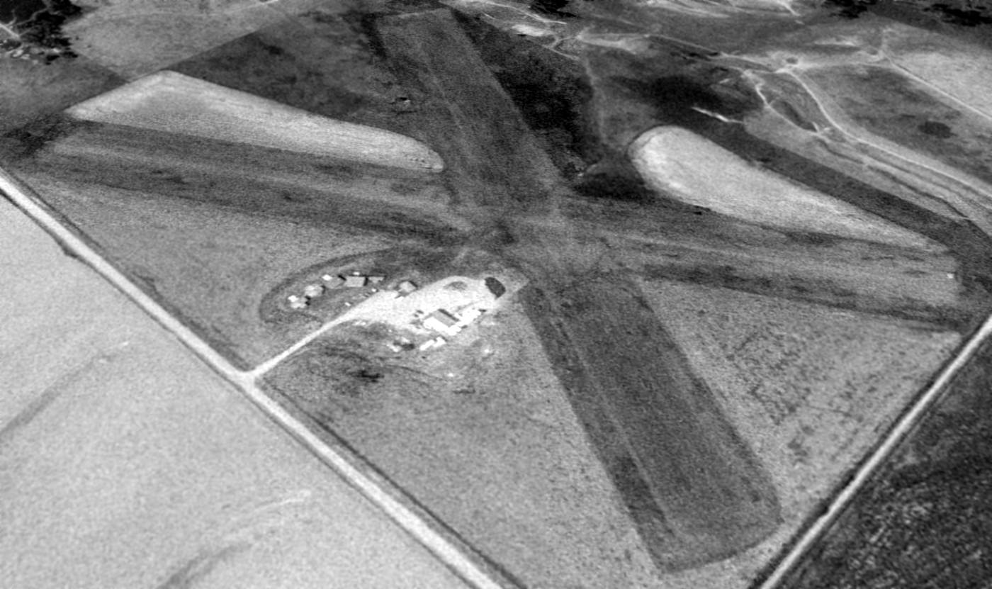
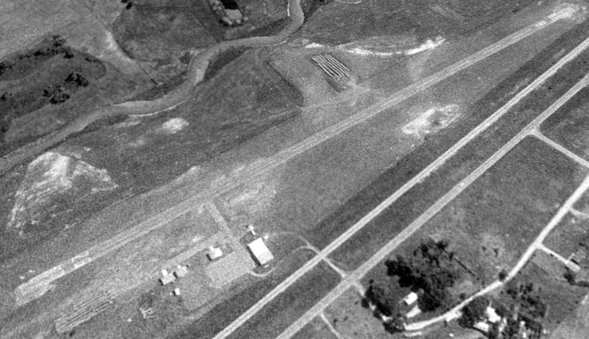
The earliest photo which has been located of Trenton Municipal Airport was a 1993 USGS aerial view looking southwest.
It depicted Trenton as having 2 unpaved runways, with a few small hangars on the east side.
There were no aircraft visible parked outside.
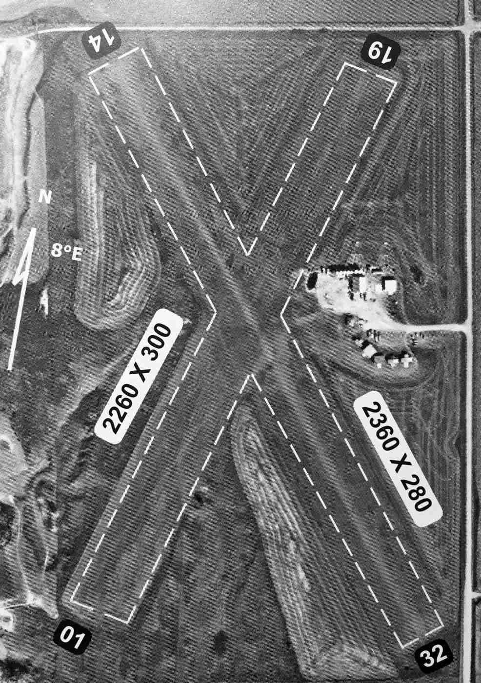
An undated aerial view of Trenton Municipal Airport from the 2009 NE Airport Directory.
It depicted Trenton as having 2 turf runways: 2,360' Runway 14/32 & 2.260' Runway 1/19.
A few small hangars were depicted on the east side. The manager was listed as Marvin Harms.
Note the 2 skeet/trap ranges just north of the hangars – an odd thing to have on an airport property.
According to its FAA Airport/Facility Directory data, for the year ending in 6/21/12,
Trenton Municipal Airport conducted an average of 72 takeoffs or landings per week.
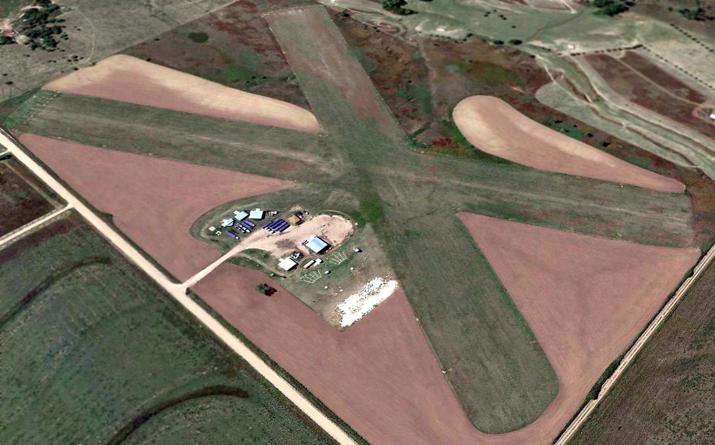
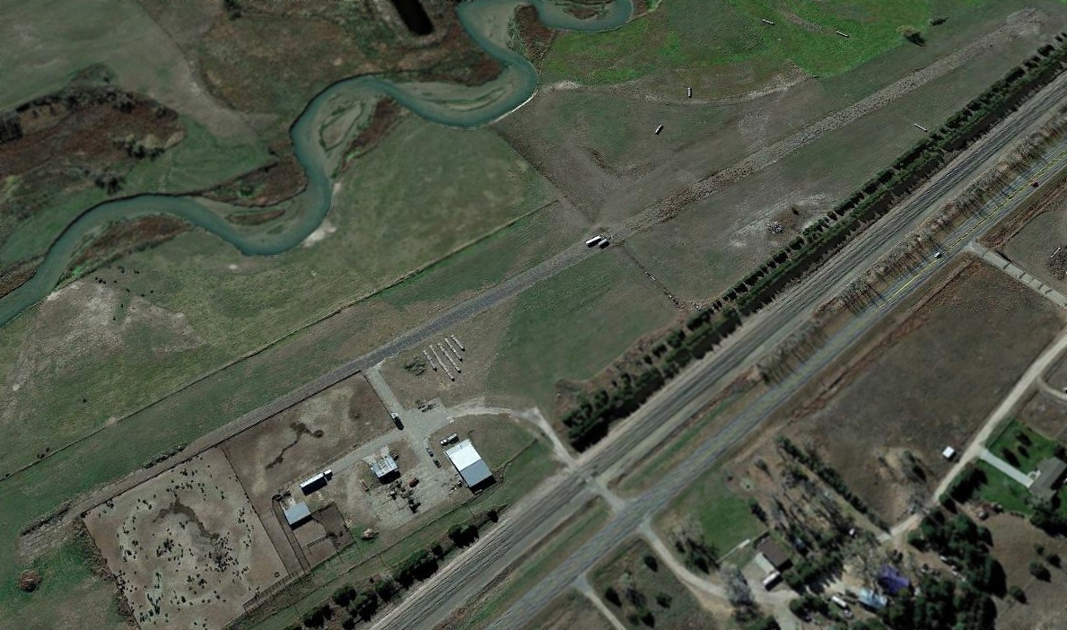
A 2014 aerial view looking southwest showed Trenton Municipal Airport to remain intact, but with trucks parked in front of the hangars,
surely a sign that its was no longer being actively being used for aviation.
Note the 2 skeet/trap ranges just north of the hangars – an odd thing to have on an airport property.
As of 2015, Trenton Municipal Airport's FAA Airport/Facility Directory data said it had a total of 2 based aircraft, both single-engine.
The owner was listed as the Village of Trenton, and the manager as John Rundel.
Trenton was said to have 2 turf runways: 2,360' Runway 14/32 (“in fair condition”) & and 2,260' Runway 1/19 (“in poor condition”).
The 2015 Cheyenne Sectional Chart depicted Trenton Municipal Airport as having a 2,300' unpaved runway.
An Associated Press Article in the 10/2/15 Lincoln JournalStar (courtesy of Chris Kennedy)
was entitled “Lack of activity cited for closure of Nebraska airport”.
It read, “So few pilots have been using the Trenton Municipal Airport in southwest Nebraska that it's been closed down.
The Village Board voted last month to take the airport out of service.
The airport has been costing the village about $2,000/year - a sizable chunk of the village's $60,000 property tax revenue.
Board chairman John Rundel said it's been several years since regular crop-dusters used the airport & more than 10 years since an airplane was based in a hangar there.
The Hitchcock County community has about 560 residents.”

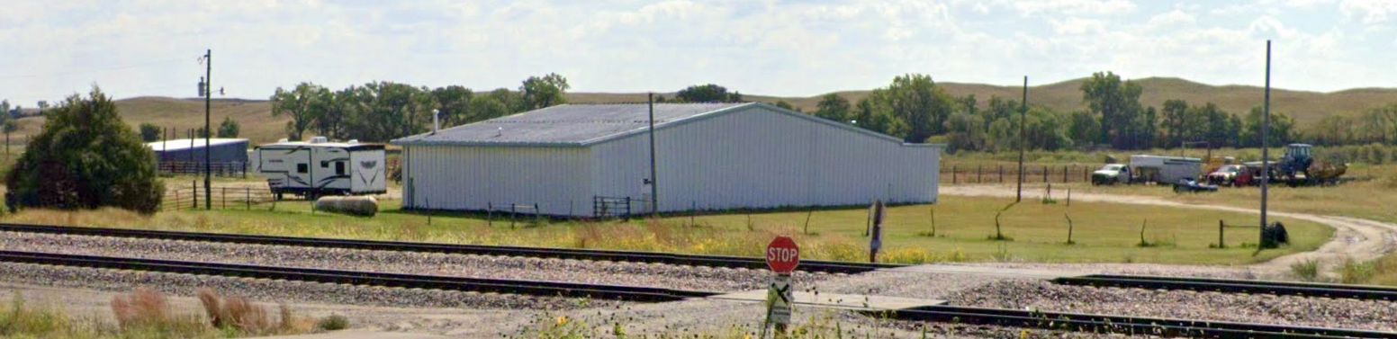
A 2023 photo looking west at former Trenton Municipal Airport hangars.
Trenton Municipal Airport is located northwest of the intersection of Route 34 & Route 364.
Thanks to Chris Kennedy for pointing out this airport.
____________________________________________________
Sioux Army Depot Airfield / Western Nebraska Technical College Airfield (7NE8), Brownson, NE
41.23, -103.1 (East of Cheyenne, WY)
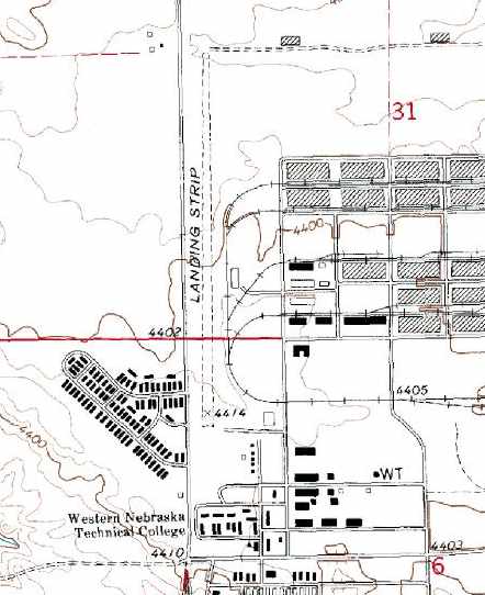
The Sioux Army Depot airfield was labeled simply as "Landing Strip" on the 1972 USGS topo map.
Photo of the airfield while open has not been located.
According to the text of a Nebraska State Historical Society historical marker,
the Army's Sioux Ordnance Depot was established on 3/23/42.
It was the only Army Ammunition Depot in Nebraska during WW2, the Korean War, and the Vietnam War.
The depot was initially under the command of the Army Ordnance Department
and later the U.S. Army Material Command.
Sioux Army Depot's mission during its entire history was the receipt, storage, and issue
of all types of ammunition from small arms to 10,000 pound bombs,
all types of general supplies from small automobile parts to jeeps, and various strategic & critical materials.
The vast depot occupied 19,771 acres & included 801 ammunition storage igloos,
22 general supply warehouses, 392 support buildings, 225 family living quarters,
51 miles of railroad tracks, and 203 miles of roads.
Personnel assigned to the Dept ranged up to a height of 2,161 civilian employees & 57 military personnel.
No airfield at the Sioux Army Depot was depicted on 1942-69 Cheyenne Sectional Charts, or on a 1960 aerial photo.
Although histories of the Depot make no mention of an airfield, a small airfield was constructed at some point,
adjacent to a complex of warehouses on the southwest side of the Depot.
Although the date of construction of the airfield has not been established,
many other Army Depots had their own airfields for logistical support of their operations,
so it is presumed that the airfield was constructed for the use of the Depot.
In 1965, Western Nebraska Vocational Technical School was founded at the Sioux Army Depot.
In October 1966, classes began at the technical vocational school.
The Sioux Army Depot was completely deactivated on 6/30/67.
Robert Kudlauskas recalled, "When I was in the USAF, working the missile fields in Nebraska,
one of our home sites was right next door to a college that used to be a military installation.
It was being used as a college & most of the buildings were still in use.
I also think that one of the buildings was used as a mini museum.
I have seen the farmer that owns the land around the storage bunkers use them as storage, mostly equipment.
The runway extended northward from the main complex.
There was also an older jet fighter sitting at the south end of the old airstrip like it was on display."
Stephen Osborn recalled, “I lived in the student housing across the street from the airstrip from spring to fall of 1970.
I remember watching plane after plane land & take off from that airstrip. They were all private aircraft.
At the beginning of the school year in the fall of 1970 the college was having a celebration
and they were giving airplane rides so I talked my mother into letting me go.
When we got over to the building that was staging the aviation they were offering airplane rides for a penny a pound.
My sister & I combined only cost about $1. That was the first time ever that I got to fly in a plane.
We took off to the south flew out for a couple miles, turned around, flew back, and landed.”
In 1971, the Western Nebraska Vocational Technical School changed its name to Western Nebraska Technical College.
Roy Rempe recalled, “I flew from 7NE8 (Vocair Flying Club member) while at WNTC in 1971, and lived 'on base'.
Snow balls could fly through the 'walls' then.
As for the 'rough RR tracks', a fellow student routinely taxied his Stinson up to the classroom when commuting, thought the Navion too,
but I remember more than one 'fly-in' parked next to the cars across from 'Airframe & Powerplants' (by the static Helio, thought that was a F-86).
My 1971 Sectional Chart didn't depict the tower or the active missile silo adjacent to Runway 17/35.
I thought real sure the latter was a tiny restricted area, but then maybe we just wisely treated it as such!”
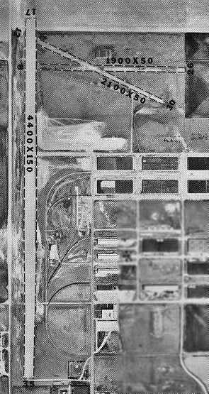
A single 4,400' north/south runway was depicted on the 1972 USGS topo map, labeled simply as "Landing Strip".
No airfield at this location was listed in the 1972 Flight Guide (according to Chris Kennedy).
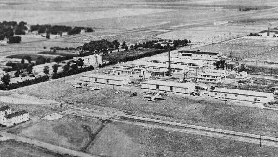
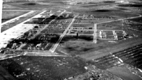
A circa early 1970s aerial view looking northwest at the Western Nebraska Technical College Airfield (courtesy of Derrick Hahn).
A DC-3, and helicopter, and several other aircraft are visible on the field.
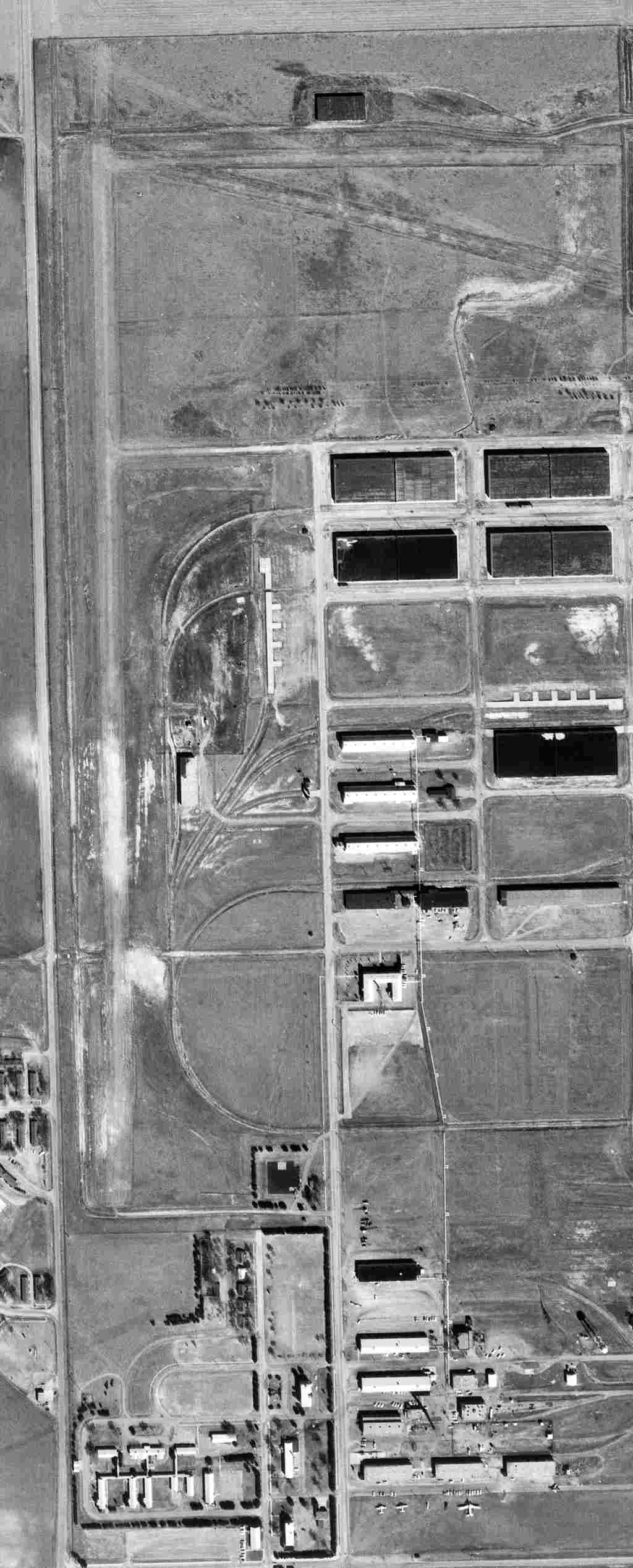
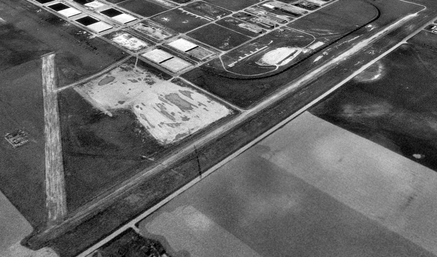
A 4/24/72 USGS aerial view of the 3 unpaved runways of the Western Nebraska Technical College Airfield. Note the static display aircraft at bottom-right.
At some point between 1972-76, the former Army Depot airfield was apparently reopened by the Western Nebraska Technical College.
An undated aerial photo of the Western Nebraska Technical College Airfield, from a state booklet (courtesy of Derrick Hahn).
It depicted the field as having 3 runways, with the 4,400' Runway 17/35 being the longest.
Derrick Hahn recalled, “I attended WNTC from 1976-78 in the Aviation Program.
I was also a pilot & used the strip there many times.
The school had an arrangement with the Civil Air Patrol to do heavy maintenance & modifications on their aircraft.
We took several surplus Beavers & converted them to civilian use.”
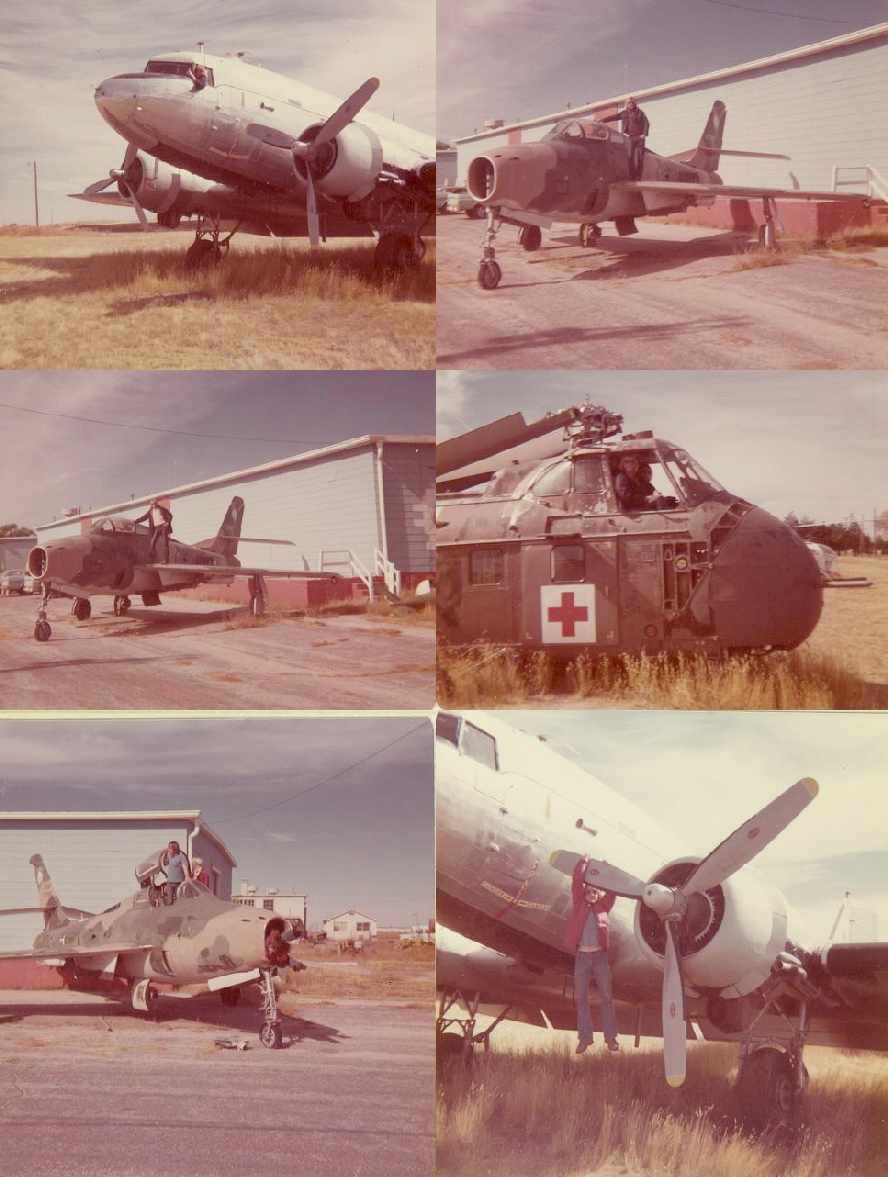
Several 1976-78 photos by Derrick Hahn of several aircraft at the Western Nebraska Technical College Airfield, including a DC-3, F-84, and H-19.
The 1979 Flight Guide (according to Chris Kennedy) described the "Western Nebraska Technical College" airfield
as having a single 3,700' unpaved Runway 17/35.
The College operated an Aviation Maintenance Program, which presumably was a user of the airfield.
A 1984 aerial photo showed the aircraft of the Western Nebraska Technical College were removed at some point between 1976-84.
Two runways at Western NE Community College were depicted on the 1986 USGS topo map, labeled simply as "Landing Strip".
Michael Beckhoff recalled, “My Dad went to A&P school there from January 1986 to April 1987,
and we lived in student housing at the college, which was of course, the old barracks.
My older sister also attended the A&P school as well from September 1986 to December 1987.
In June of 1986 I was 12 years old, and I had my first airplane ride in a 1960 Cessna 172 that the college flying club kept at the field.
The flying club also had a Cessna 150.
The college owned many airplanes, some of which were used to train student mechanics;
they included an early 310, an O-2A, several De Haviland Beavers (in pieces) several Beech 18’s (in pieces), several old helicopters,
and a very nice Cessna 206 that the college used to use for business and to give rides in on open house day.
Most of these aircraft were kept in the northern-most warehouse building that was closest to the runway.
I can remember there being a few airplanes in there that didn’t belong to the college as well:
a Maule M-5, and a super nice 47 Bonanza.
One of my Dad’s classmates had a Cessna 140 that the college let him keep there while he was attending.”
Michael continued, “The A&P school was actually in a building that was at the opposite end of the campus,
airplanes were taxied down the street & across the area leading to the runway.
To the best of my knowledge, the runway was never paved.
It was a grass strip back in the day when it was being used all of the time.
The jet fighter that used to sit up near the North end of the runway next to the warehouse was an F-84.
It now resides as a gate guardian at the airport in Cheyenne, WY, off of Del Range Boulevard near the Air National Guard Facility.
The airplane was airlifted out by a Skycrane in 1988, I do believe.
The Beavers & the Beech 18’s as well as a lot of parts that were stashed in the warehouse were sold off to Duff Aviation in Denver.
The WNCC Flying Club still had the 150 & the 172 last I knew,
however I am not sure what became of the 206.”
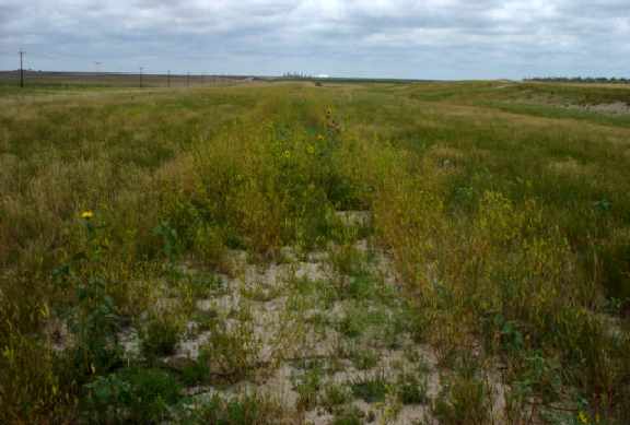
A 1993 USGS aerial view looking southeast at the remains of the 2 runways at the site of the Western Nebraska Technical College Airfield.
In 1995 the College's Sidney Center vacated its facilities at the former Depot, which were sold in August 1996 to a private enterprise.
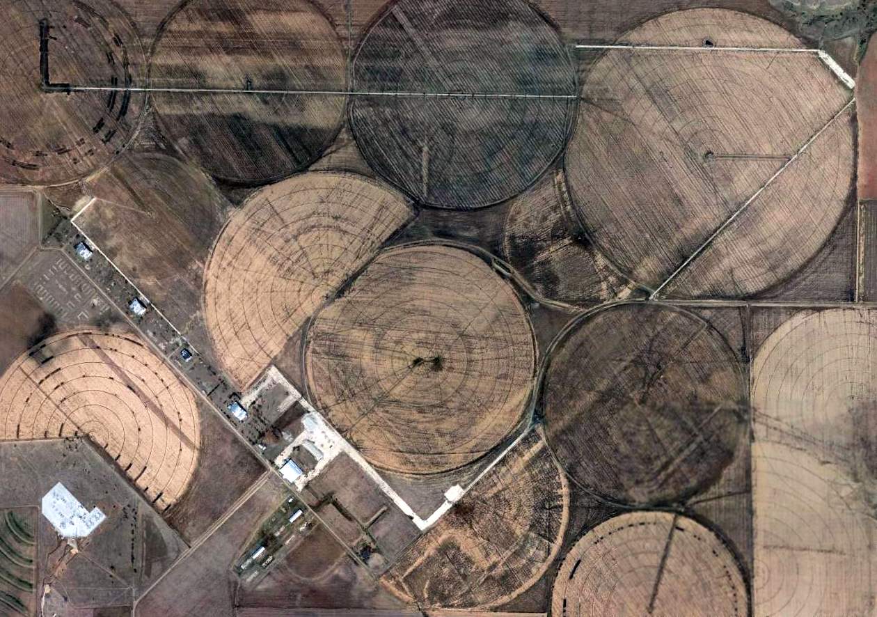
A 2005 photo by Keith Wood of the area of the former Sioux airfield.
Keith reported, “Nothing remains of the runway except a raised area and a bit of the gravel underbase.
There is no indication of any buildings near the airstrip, certainly no hangars. The big buildings seen there are warehouses & light industry.
You can't tell, but there is a rail line between the runway & the rest of the base.
In my experience, this means that the planes never left the airstrip (too much chance for damage crossing rail lines).
The only indication that there were every any aviation activities was an old sign for the 'Aviation Shop', which is on a warehouse a long way from the runway.”
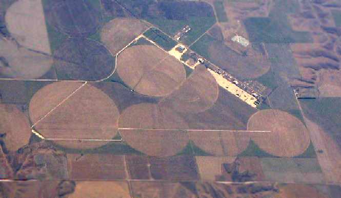
A 2015 aerial view looking southeast showed the a new railroad line having been constructed over the alignment of the 2 former runways of the Western Nebraska Technical College Airfield.
The site of the Western Nebraska Technical College Airfield is located northwest of the intersection of Industrial Avenue & Douglas Street.
____________________________________________________
McCook Army Airfield / McCook State Airport, McCook, NE
40.31, -100.7 (Southwest of Lincoln, NE)
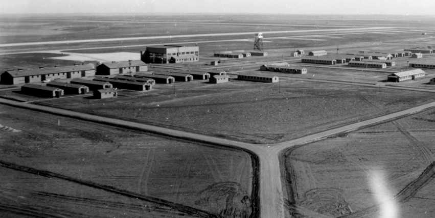
An “early” (circa 1943) aerial view looking east along the McCook flightline (courtesy of Floyd Mellon).
McCook Army Airfield was not yet depicted on the July 1942 Lincoln Sectional Chart.
Floyd Mellon recalled, “My father, Major Leo Mellon was a member of a group of officers
that flew far & wide in a B-17 to locate proper places for new air bases.
McCook was one that they selected to be built.
Low and behold, he was then made the first commanding officer of McCook Army Airbase.”
McCook AAF was activated in 1943 as one of 11 WW2 Army Air Force training bases in Nebraska.
The base provided final training of heavy bomber crews for the B-17, B-24 & B-29.
The 2,100 acre base originally included three 7,500' concrete runways, five hangars & barracks for 5,000 men.
Some 15,000 servicemen and 500 civilians were stationed at the base.
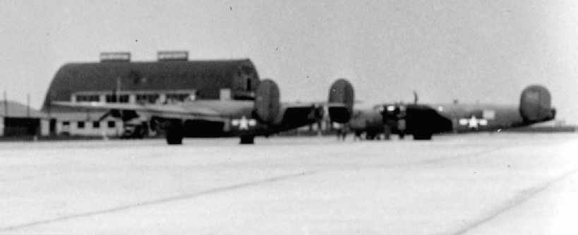
A circa 1943-44 photo of B-24 Liberator bombers on the ramp at McCook (courtesy of Floyd Mellon).
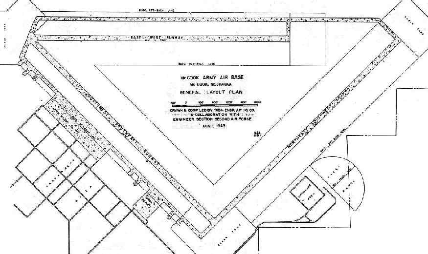
A 1943 Army plan of McCook AAF, courtesy of John Voss.
Floyd Mellon recalled, “My mother & I lived in McCook with dad, and I, as a 4th grader, had the run of the base:
gun turrets, both Martin upper turrets & Sperry ball turrets, Link Trainers, gymnasium, Officers Club,
bombing practice towers in a big hangar, with the bombsight no less.
I actually got to drop a virtual bomb.”
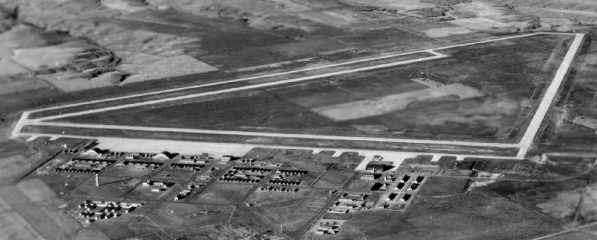
A circa 1943-44 aerial photo looking northeast at McCook AAF (courtesy of Floyd Mellon).
A circa 1943-44 aerial photo looking northwest at McCook AAF (courtesy of Floyd Mellon).
An undated (circa 1940s?) aerial view looking southeast at McCook, with the ramp on the left
(from the Air Force Historical Research Agency, Maxwell AFB).
An undated (circa 1940s?) aerial view of 4 Link Celestial Navigation Training Towers behind a McCook hangar.
The following USAAF Groups were stationed at McCook:
454th Bombardment Group (Heavy), July-October 1943,
736th, 737th, 738th, and 739th Bombardment Squadrons,
486th Bombardment Group (Heavy), September-November 1943,
832nd, 833rd, 834th, and 835th Bombardment Squadrons,
465th Bombardment Group (Heavy), October 1943 - February 1944,
780th, 781st, 782nd, and 783rd Bombardment Squadrons,
493rd Bombardment Group (Heavy), November 1943 - January 1944,
860th, 861st, 862nd, and 863rd Bombardment Squadrons,
9th Bombardment Group (Very Heavy), May-November 1944,
1st, 5th, 99th, and 430th Bombardment Squadrons,
331st Bombardment Group (Very Heavy), November 1944 - April 1945,
355th, 356th, and 357th Bombardment Squadrons (B-29 Superfortress),
98th Bombardment Group (Very Heavy), June-November 1945,
343rd, 344th, 345th, and 415th Bombardment Squadrons (B-29 Superfortress), inactivated 11/18/45,
448th Bombardment Group (Very Heavy), September-December 1945,
712th, 713th, 714th, and 715th Bombardment Squadrons, inactivated 12/4/45.
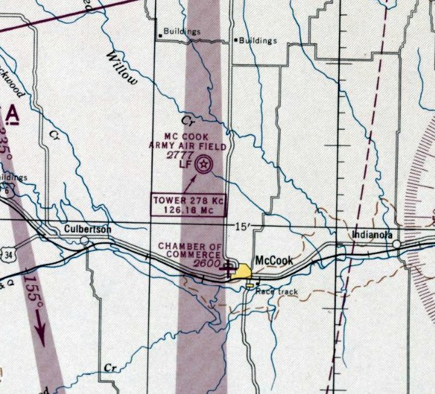
The earliest aeronautical chart depiction which has been located of McCook Army Air Field was on the March 1944 Lincoln Sectional Chart.
The base closed in 1945, and the property was transferred to the State of Nebraska in 1947,
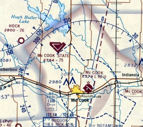
who operated it as a civil field named McCook State Airfield.
"McCook State" Airport was depicted on the November 1948 Lincoln Sectional Chart (courtesy of Chris Kennedy)
as having a 7,500' hard surface runway.
McCook State Airport was listed among active airports in the 1962 AOPA Airport Directory,
with 3 concrete runways: 8/26, 12/30, and 3/21.
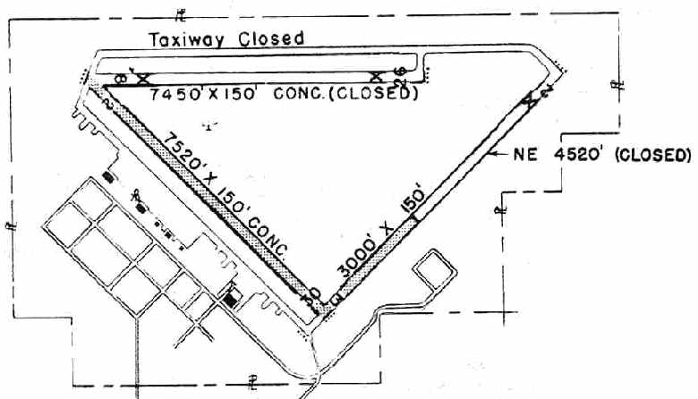
The 1950 NE Airport Directory (courtesy of Chris Kennedy) depicted McCook as having 3 paved runways, of which 2 were still active
(all of the 7,520' Runway 12/30, but only a 3,000' portion of Runway 3/21).
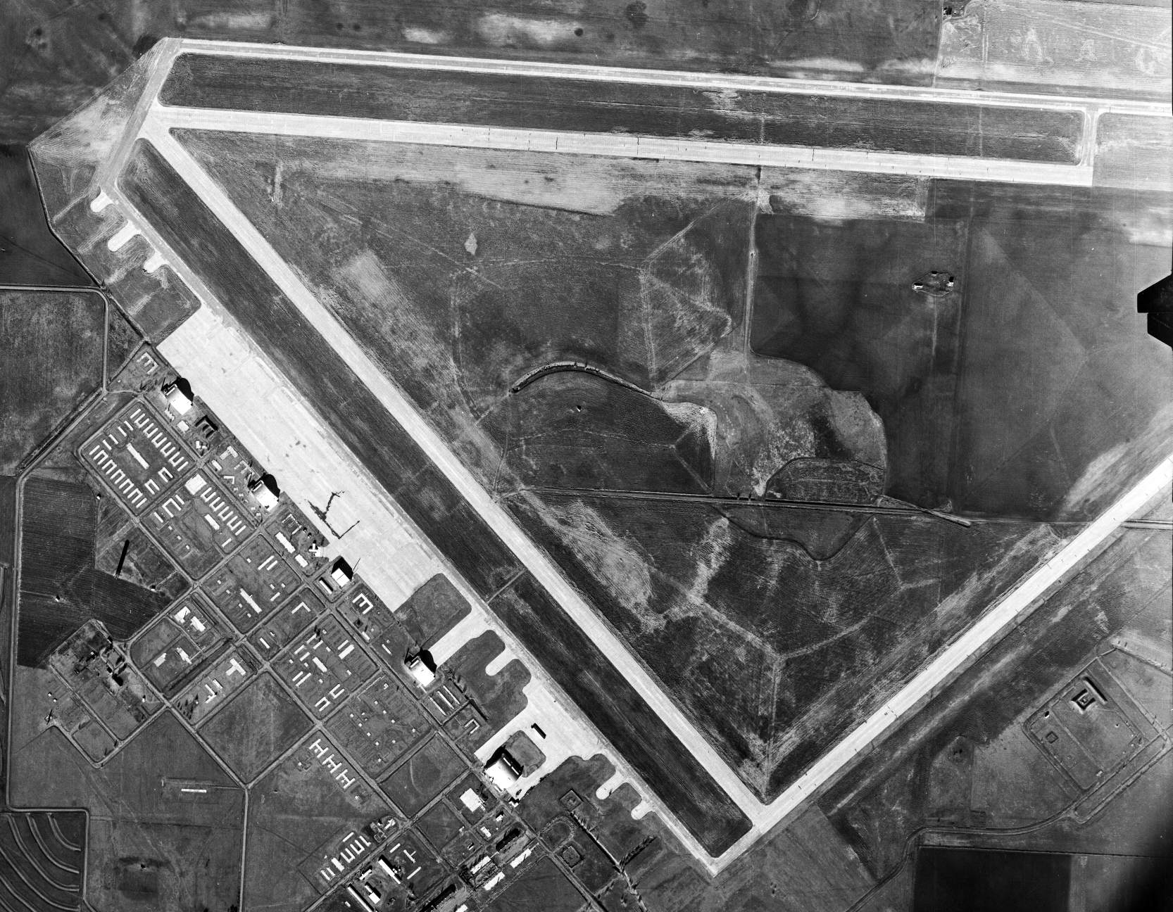
A 1/3/57 USGS aerial view depicted the massive airfield of McCook State Airport, but did not show a single aircraft on the field.
"McCook State" Airport was depicted on the October 1968 Lincoln Sectional Chart (courtesy of Chris Kennedy) as having 3 runways,
with the longest being a 7,520' concrete strip, but the remarks in the Aerodromes table said "Runway 3/21 closed."
The last aeronautical chart depiction which has been located of McCook State Airport was on the April 1969 Lincoln Sectional Chart.
It depicted McCook as having 3 paved runways, with the longest being 7,500'.
McCook State Airport was subsequently closed in 1969,
as it was labeled "Abandoned airport" on the October 1969 Lincoln Sectional Chart.
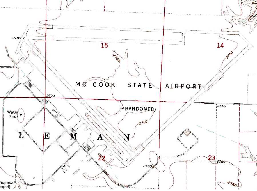
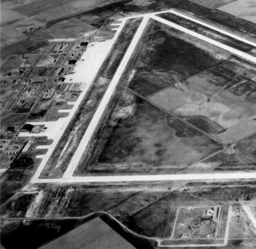
The 1981 USGS topo map depicted “McCook State Airport (Abandoned)” as having 3 paved runways, taxiways, ramps, and 5 hangars on the southwest side.
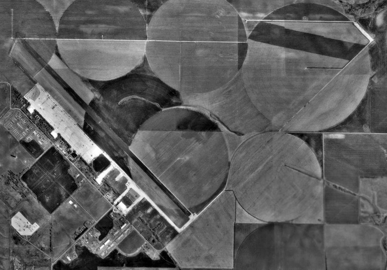
In the 1993 USGS aerial photo, the majority of the McCook AAF runway pavement had been removed, but the outlines of the east/west & northwest/southeast runways were still plainly apparent.
By the time of the 1999 USGS aerial photo, the McCook runways were even less recognizable,
with only a narrow strip of pavement remaining along the former alignment of the east/west & northeast/southwest runways.
The majority of the ramp area was still paved, and 4 hangars remained standing.
Today the McCook land is owned primarily by farmers & the Nebraska Bureau of Land Management.
A 2004 photo by Robert Pearson of all 5 remaining WW2-era hangars at McCook.
![]()
A 2004 photo by Robert Pearson of the front of the former transient aircraft hangar at McCook.
According to Keith Wood, 3 other hangars of identical design are still standing (and in better condition) at Wendover UT.
![]()
A 2004 photo by Robert Pearson of the rafters inside the former transient aircraft hangar at McCook.
A 2004 photo by Robert Pearson of the former sub-depot hangar at McCook.
Robert Pearson visited McCook in 2004, and reported: "This is the only mid-west B-29 base I know of that all 5 hangars have survived.
The runways have not done as well with only a 30' wide strip left for the farmer to access his irrigation equipment.
The back extension from the hangar has 2 rest lounges, the smaller for officers and the larger for the enlisted, I assume.
The barracks for the visitors (enlisted I'm sure) is right behind the hangar. McCook also has its engine servicing building still standing.
It is just to the left of the sub-depot hangar. The other 3 hangars are of the typical mid-west B-29 style.
There are 2 warehouses left & several small buildings."
A February 2005 photo by Phil Brooks looking south at McCook.
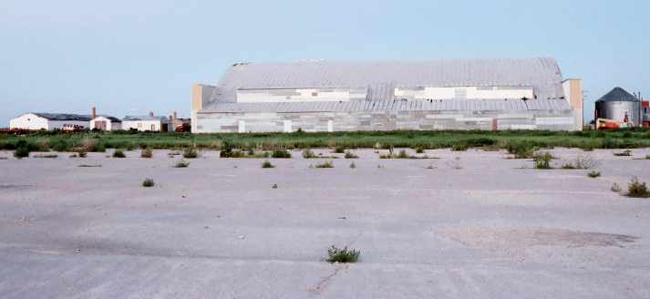
A 7/23/10 photo of a former McCook AAF hangar, reused for farm storage.
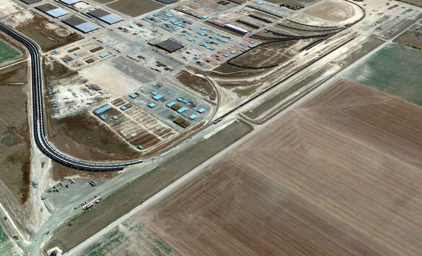
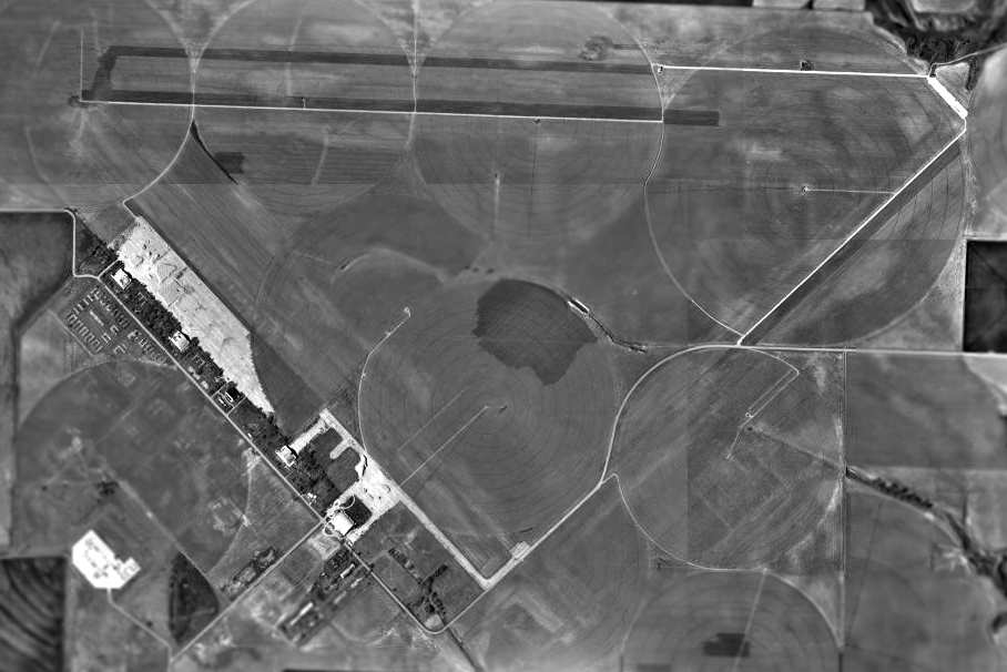
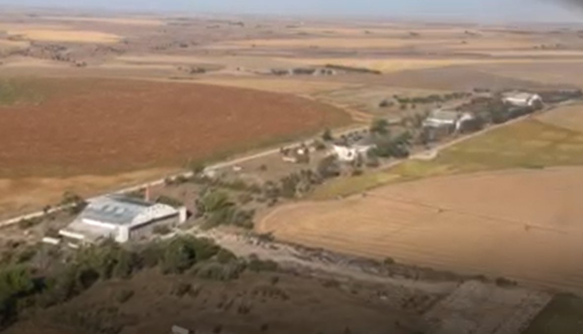
A 2014 aerial view of the remains of the massive McCook AAF airfield.
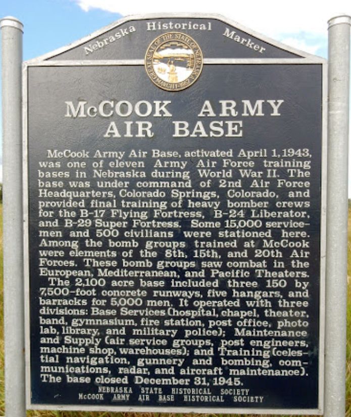
A 2015 photo of a historical marker commemorating McCook Army Air Base.
A still looking west from a 9/26/21 video by Kevin Brown of the row of former hangars at McCook Field.
A 2023 photo of a former McCook AAF hangar.

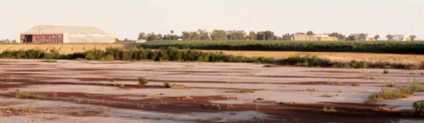
A 2025 or earlier photo looking along the remains of a McCook AAF runway (courtesy of Kevin Walsh).

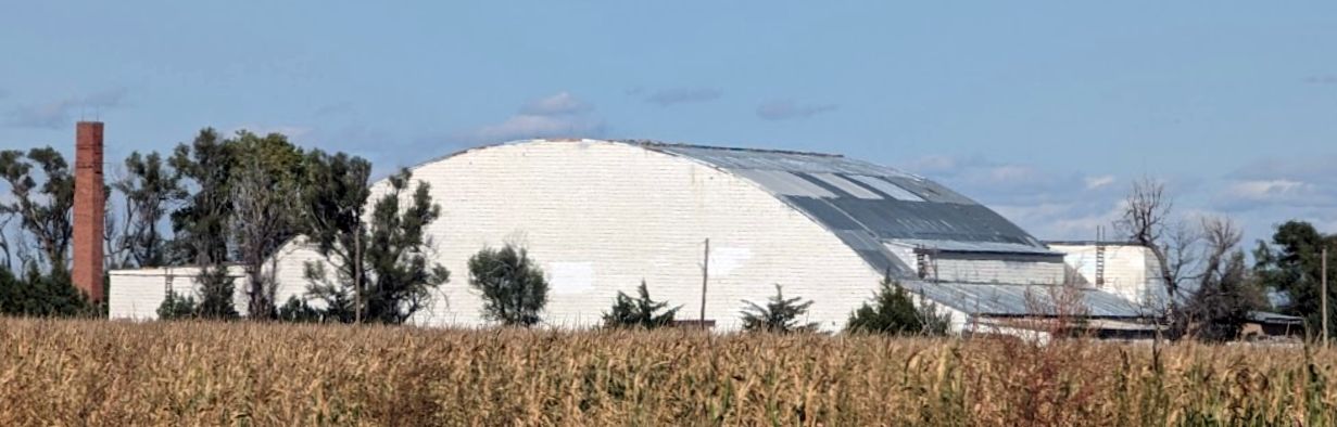
A 2025 or earlier photo of a former McCook AAF hangar, reused for farm storage (courtesy of Kevin Walsh).
See also:
http://www.hnd.usace.army.mil/OEW/Factshts/factshts/mccook.pdf
http://www.nde.state.ne.us/SS/markers/347.html
____________________________________________________
Or if you prefer to contact me directly concerning a contribution (for a mailing address to send a check),
please contact me at: paulandterryfreeman@gmail.com
If you enjoy this web site, please support it with a financial contribution.
____________________________________________________
This site covers airfields in all 50 states.