Abandoned & Little-Known Airfields:
Texas, Southwestern Fort Worth Area
© 2002, © 2026 by Paul Freeman. Revised 3/3/26.
This site covers airfields in all 50 states: Click here for the site's main menu.
____________________________________________________
Please consider a financial contribution to support the continued growth & operation of this site.
Taliaferro Field #2 / Barron Field (revised 3/3/26) - Taliaferro Field #3 / Carruthers Field / Benbrook Field (revised 11/16/22) - Luck Field (revised 7/21/22)
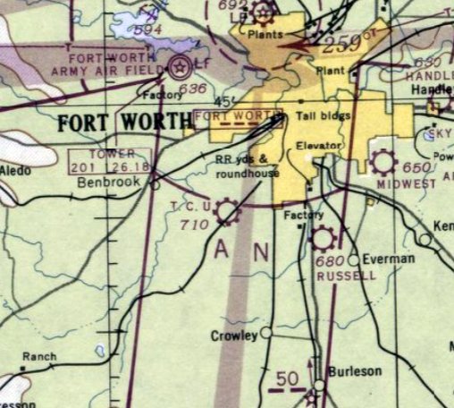
Parker Intermediate Field / Parker Airport (added 9/3/18) - Singleton Field / Russell Field (revised 2/22/26) - TCU Airfield (revised 1/17/22) - Weatherford Airport (revised 11/10/23)
____________________________________________________
Parker Intermediate Field / Parker Airport, Parker, TX
32.251, -97.282 (Southwest of Fort Worth, TX)
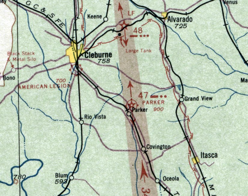
Parker Intermediate Field, as depicted on the August 1934 Dallas Sectional Chart.
Photo of airfield has not been located.
This early airfield was evidently established at some point between 1932-34,
as it was not yet depicted on the 1932 Dallas Sectional Chart (courtesy of Roger Connor).
The earliest depiction which has been located of Parker Intermediate Field was on the August 1934 Dallas Sectional Chart.
It depicted Parker as the Commerce Department's Site 47,
one of its network of Intermediate Fields established in the 1930s for the emergency use of commercial aircraft on airways between major cities.
Bill Hughes recalled, “As a very young kid I remember a WWII Army Air Force airport located in the northeast quadrant of the junction of FM 916 & State 171.
The beacon was real close to the intersection of the 2 highways. Probably no more than a couple of hundred feet either way.
As a kid the beacon flashed through my bedroom every 60 seconds.
There was a very large (to a little kid) metal hangar [in the center of the field].
A culbert located opposite of CR 1103 provided auto access to the hangar.
About 1946 I saw a [Cessna] 140 or 170 on is back on this strip.”
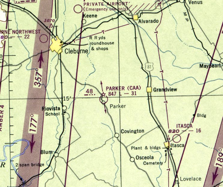
The last aeronautical chart depiction which has been located of Parker Airport was on the September 1948 Dallas Sectional Chart.
It depicted “Parker (CAA)” (Civil Aeronautics Administration) as having a 3,100' unpaved runway.
Parker Airport was evidently closed at some point between 1948-49,
as it was no longer depicted on the 1949 Dallas Sectional Chart.
It had lasted longer than many other Commerce Department Intermediate Fields,
as their need for emergencies had been mostly obviated by the increased reliability of commercial aircraft.
Parker Airport was not depicted on a 1956 aerial photo or the 1960 USGS topo map.
Bill Hughes recalled, “The beacon was removed sometime in the early 1960s.”
A 1995 aerial view showed no trace of Parker Airport, with the land having been returned to cultivation.
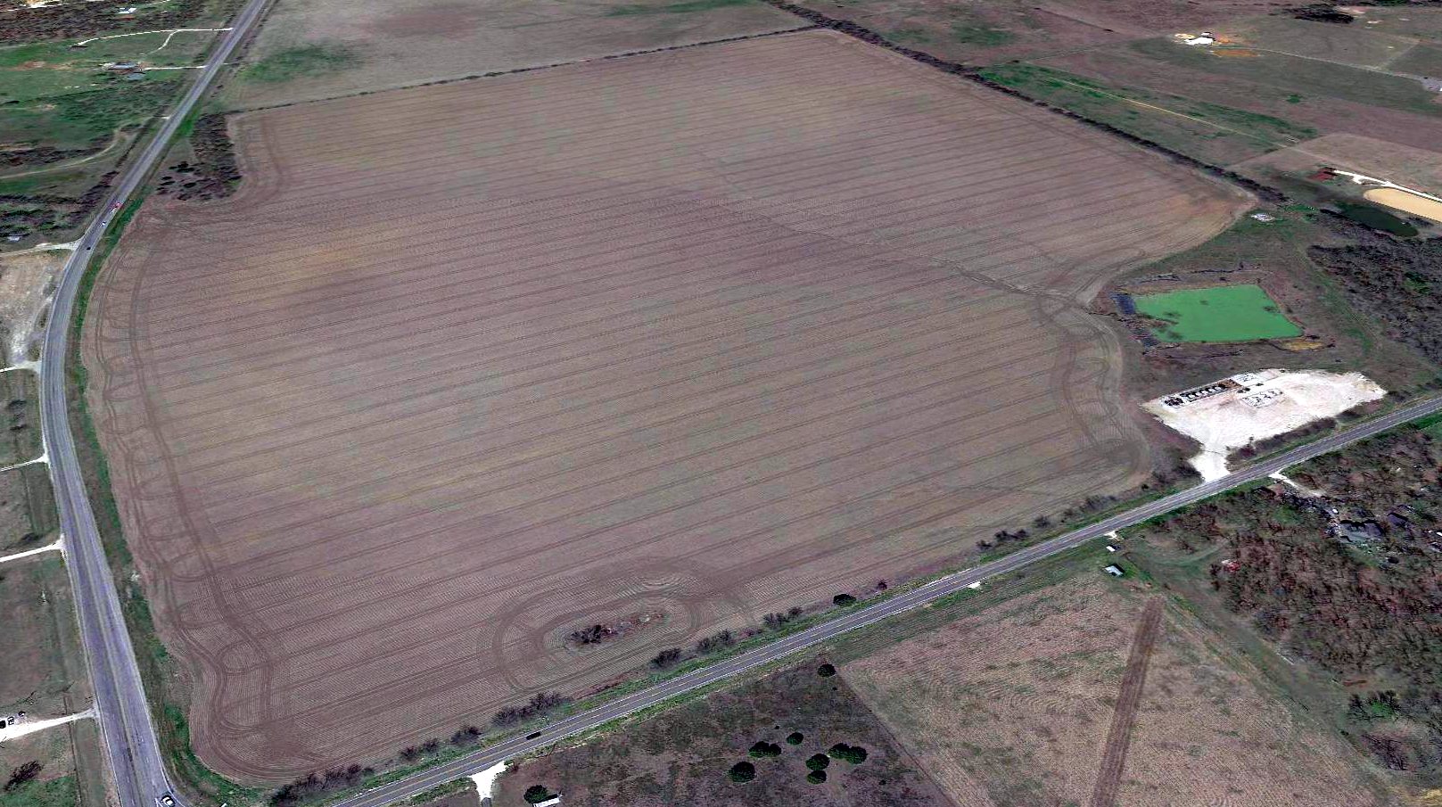
A 2018 aerial view looking north showed no trace of Parker Airport.
Thanks to Bill Highes for pointing out this airfield.
____________________________________________________
Weatherford Airport, Weatherford, TX
32.75, -97.813 (West of Fort Worth, TX)
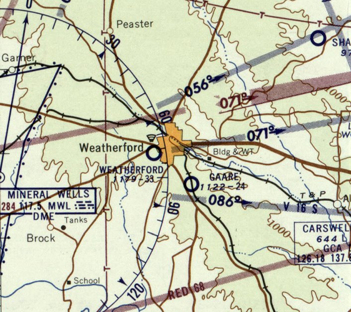
Weatherford Airport, as depicted on the August 1934 Dallas Sectional Chart.
This early general aviation airport was evidently established at some point between 1932-34,
as it was not yet depicted on the 1932 Dallas Sectional Chart.
The earliest depiction which has been located of Weatherford Airport was on the August 1934 Dallas Sectional Chart.
It depicted Weatherford as an auxiliary airfield.
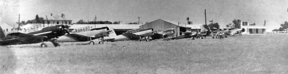
The earliest photo which has been located of Weatherford Airport was a circa 1940s photo (courtesy of Carl Rousseau)
showing a row of 8 single-engine taildraggers (Vultee BT-3 Valiants & some other military surplus aircraft) on grass in font of a hangar.
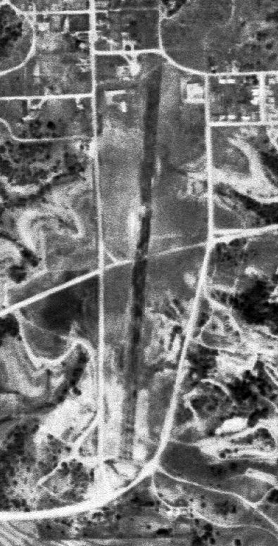
The only aerial photo which has been located of Weatherford Airport was a 3/31/53 USGS aerial view.
It depicted Weatherford as having a single northeast/southwest runway, with a few small buildings on the north end.
The last aeronautical chart depiction which has been located of Weatherford Airport was on the January 1957 Dallas Sectional Chart.
It depicted Weatherford as having a 3,300' unpaved runway.
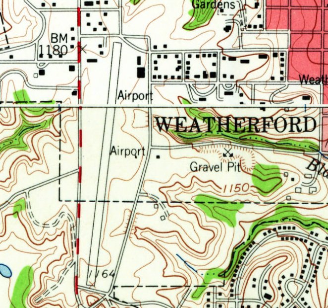
The 1959 USGS topo map depicted Weatherford Airport as having a single paved northeast/southwest runway, with 5 small buildings on the north end.
Weatherford Airport was evidently closed (for reasons unknown) at some point between 1957-60,
as it was no longer depicted on the August 1960 Dallas Sectional Chart.
The 1979 USGS topo map no longer depicted Weatherford Airport.
A 1981 aerial view showed several buildings covering most of the Weatherford Airport site.
Don Johnson reported in 2015, "Old Weatherford Airport... The terminal sat west of approximately (where) the National Guard Armory is now."
Carl Rousseau reported, the “National Guard Armory is still there today, on the northeast corner of the old airport property.
The terminal would have been in the northwest corner of the field on Bowie Street.”
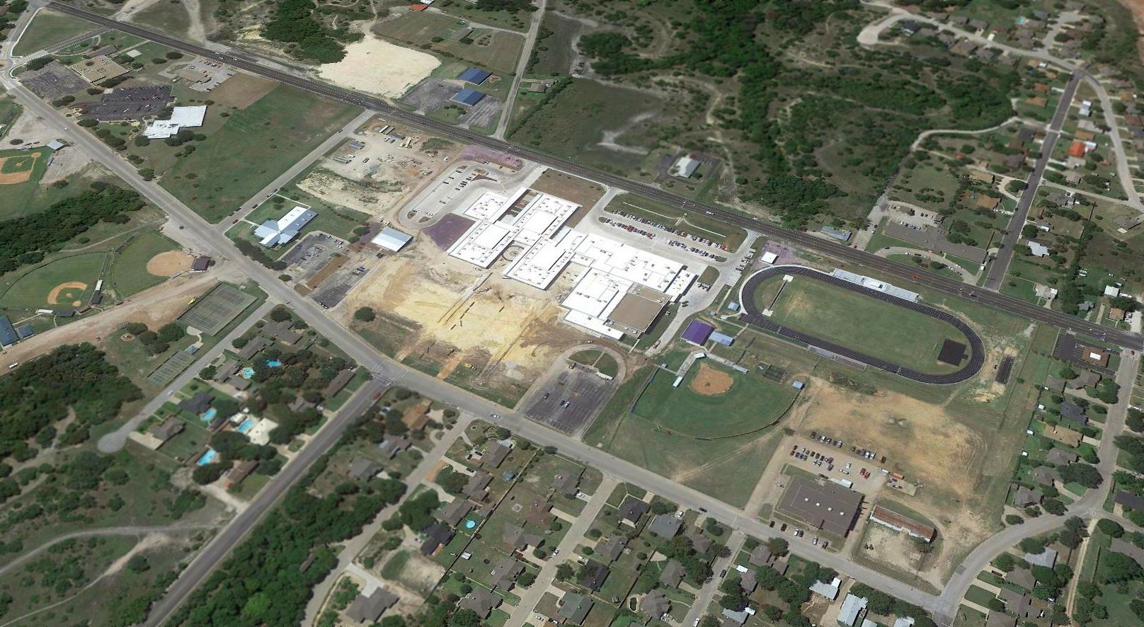
A 2017 aerial view looking southwest showed no trace remains of the Weatherford Airport.
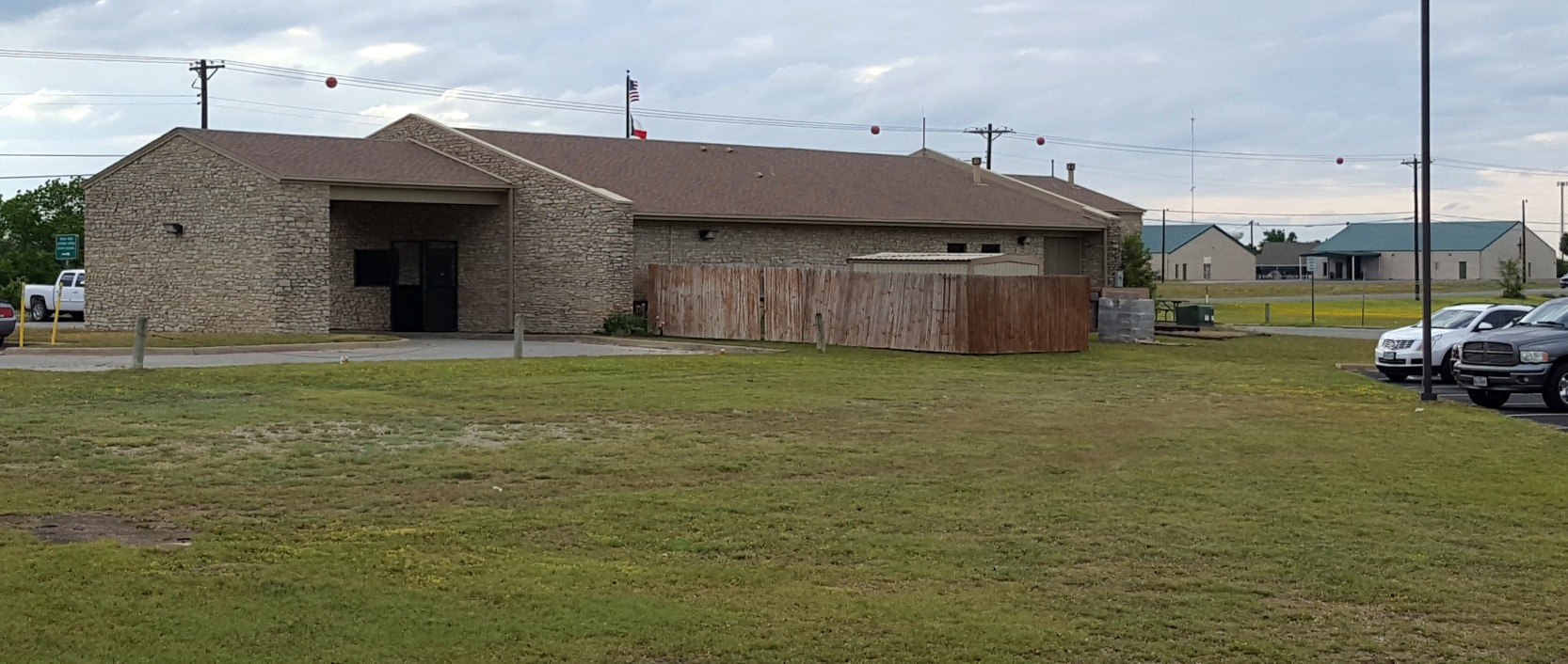
A 4/30/18 photo by Carl Rousseau of the DPS building on the north side of the Weatherford Airport site.
Two clues to the property's history as an airport still remain: the red marker balls on the power lines in the background,
and a small patch of runway or taxiway pavement at bottom-left.
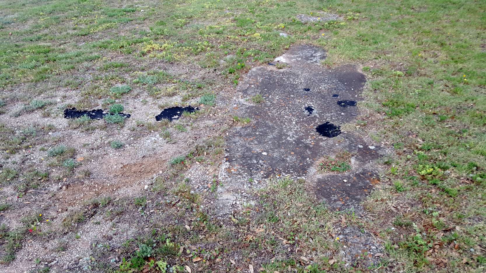
A 4/30/18 photo by Carl Rousseau of the small patch of runway or taxiway pavement which remains next to the DPS building on the north side of the Weatherford Airport site.
Thanks to Carl Rousseau for pointing out this airfield.
____________________________________________________
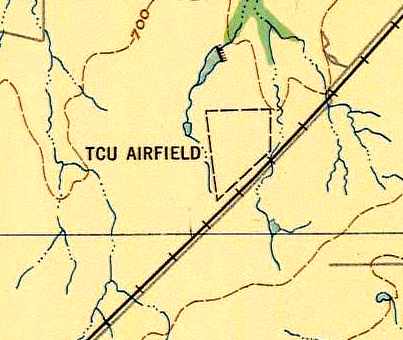
32.67, -97.4 (Southwest of Downtown Fort Worth, TX)
A 1946 aerial view looking northwest at TCU Airport (courtesy of Jerrell Baley).
Note the plane in flight over the runway intersection.
This short-lived airfield was operated by Texas Christian University (located a few miles to the northeast).
TCU Airfield was apparently established in 1946, as it was not yet depicted on the March 1946 Dallas Sectional Chart.
The earliest reference to TCU Airport came from Jim Ewing, who recalled,
“My first flight at TCU Airport was 6/2/46. I received my Private Pilot License 8/24/46.
My instructor was Howard Hale. One [logbook] entry leads me to believe B. M. Roberts was the airport owner.
We had one north/south grass runway with high lines at the north end.”
The earliest depiction of TCU Airfield which has been located was a 1946 aerial view (courtesy of Jerrell Baley).
It depicted TCU as having 2 perpendicular grass runways, with a few small buildings northeast of the runway intersection.
The photo showed a single plane in flight right over the runway intersection.

The earliest aeronautical chart depiction of TCU Airfield which has been located was on the September 1946 Dallas Sectional Chart.
The 1948 USAF Target Complex Chart (courtesy of David Brooks)
depicted the "TCU Airfield" as an irregularly-shaped area, bounded by the railroad tracks on the southeast side.
No runways or buildings were depicted at the field.
David Brooks reported that the field "appears to have supported an Air Force ROTC unit
where flight training took place for students in the ROTC at TCU."
Ganey Bradfield reported, “I live directly across the railroad track from the obtuse angle in the southeast airport boundary.
I have lived at this location since 1951.
I have flown off the TCU airport many times (with the CAP).”
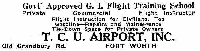
An undated advertisement for flight training at TCU Airport (courtesy of Tom Williams).
A 4/1/52 USGS aerial view showed TCU Airport as having 2 unpaved runways, with several small buildings on the northeast side.
Al Pugsley recalled, “I took my 1st flight lesson at TCU Airport on 3/6/55 in an Aeronca 7CCM, N4707E.”
Ganey Bradfield recalled, “I remember flying off the airport in the late 1950s.
The entrance road to the airport crossed the track pretty much where Wedgemont Circle North intersected Granbury Road.”
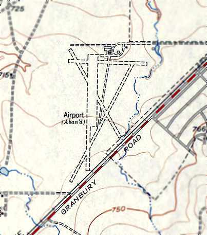
The TCU Airport must have closed within 1955, as the 1955 USGS topo map (courtesy of Ganey Bradfield) depicted it as “Airport (Abandoned)”.
It still depicted 3 runways, multiple taxiways, a ramp, and 2 small buildings.
The last aeronautical chart depiction of TCU Airfield which has been located was on the March 1956 Dallas Sectional Chart.
It depicted TCU Airfield as having a 3,000' unpaved runway.
A 1956 aerial photo evidently depicted TCU Airfield after it had been abandoned.
Multiple grass runways remained intact, along with several hangars on the north side,
but there were no planes or other signs of recent aviation usage.
The TCU Airfield was no longer depicted at all on the January 1957 DFW Sectional Chart.
A 1959 aerial view looking north (courtesy of Jerrell Baley) showed that a housing development had covered the site of TCU Airport.
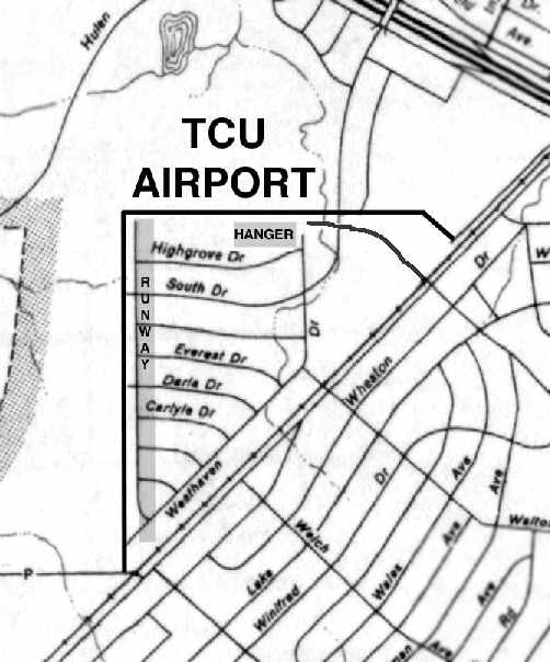
The location & layout of TCU Airport, superimposed by Ganey Bradfield on a 1963 TX Highway Department map.
Ganey Bradfield recalled, “In 1963, the Westwood Addition to Fort Worth had been developed. It was developed on the TCU Airport property.”
There was no trace remaining evident of TCU Airport on a 1970 aerial photo.
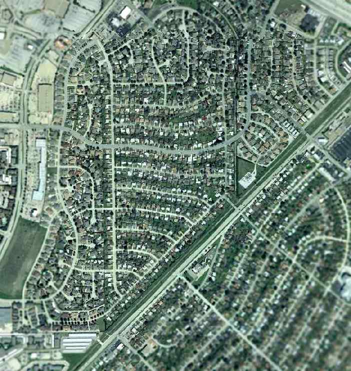
A 2001 USGS aerial photo showed not a trace remained of TCU Airport.
The site of TCU Airfield is located northwest of the intersection of Wedgemont Circle North & Granbury Road.
____________________________________________________
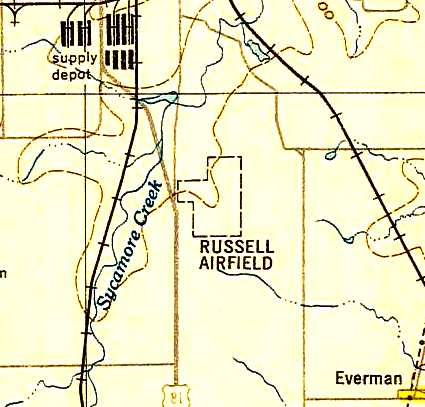
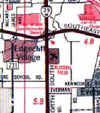
Singleton Field / Naval Outlying Field 25521 / Russell Field, Everman, TX
32.65, -97.31 (South of Fort Worth, TX)
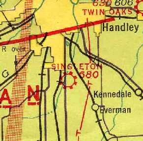
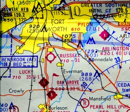
Singleton Field, as depicted on the February 1942 Dallas Sectional Chart (courtesy of Chris Kennedy).
This general aviation airport was evidently opened at some point between 1941-42,
as it was not yet depicted on the August 1941 Dallas Sectional Chart,
nor listed among active airfields in the Airport Directory Company's 1937 Airports Directory (courtesy of Bob Rambo).
The earliest depiction of Singleton Field which has been located
was on the February 1942 Dallas Sectional Chart (courtesy of Chris Kennedy).
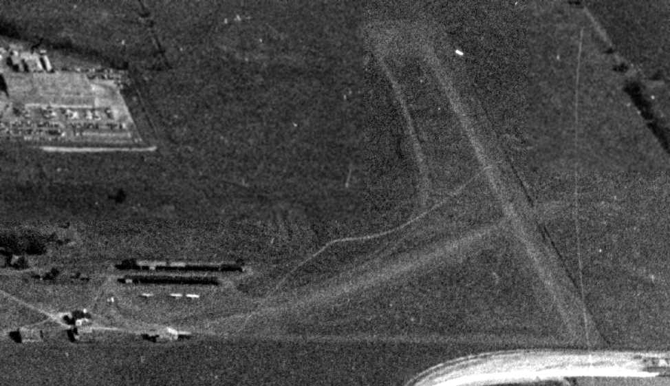
The earliest photo which has been located of Singleton Field was a 4/19/43 U.S. Navy aerial view looking north (courtesy of Brian Rehwinkel)
was labeled "proposed field (Singleton) for NAS Dallas."
It depicted Singleton Flying Field as an L-shaped grass area with several hangars at the southeast end.
A closeup of the southeast corner of Singleton Field from the 4/19/43 U.S. Navy aerial view (courtesy of Brian Rehwinkel)
showed 2 hangars & 10 individual T-hangars, along with at least 6 aircraft.
Brian Rehwinkel reported, “According to a 3/1/43 'Outlying Field Report' for NAS Dallas,
the Navy requested the use of the airfield [Singleton Field] for training purposes.
According to a 9/4/43 US Navy memo, the lease was apparently completed in September 1943
when the Navy leased 130 acres from J. R. (Bob) Singleton for $2,000 per year.
The field was designated Bureau of Aeronautics # 25521.”
A 10/15/43 aerial view looking north from the 1945 AAF Airfield Directory (courtesy of Scott Murdock)
depicted “Singleton Flying Field” as an L-shaped grass area.
Brian Rehwinkel reported, “A 12/30/43 'Outlying Field Report' describes describes the field surface & runways as being sod.
Interestingly, the report also indicated there are no buildings on the field -
even though the Navy's own photo taken in April 1943 clearly shows what look like 2 hangars & other structures.”
The April 1944 US Army/Navy Directory of Airfields (courtesy of Ken Mercer)
described Singleton Field as having a 2,400' unpaved runway.
The 1945 AAF Airfield Directory (courtesy of Scott Murdock) described “Singleton Flying Field”
as a 124 acre rectangular property within which were 4 graded runways, the longest being the 2,250' north/south strip.
The field was said to have 2 wood & metal hangars, measuring 60' x 54' & 54' x 46'.
Singleton was said to be owned & operated by private interests, but also to be used by the Navy.
Brian Rehwinkel reported, “Singleton Field was leased by the Navy through the end of the war.
A September 1945 Navy document from the Chief of Naval Operations to the Bureau of Aeronautics
indicated Singleton OLF would become excess to the Navy's needs on 4/1/46.
If this was the case, the lease would have been canceled - or not renewed - around that time.”
However, this chronology is possibly slightly contradicted by Vernon Russell,
who recalled, “My dad, Buck Russell, owned & renamed Russell Field in 1944 or 1945.”
According to Don Newton, Buck Russell's “first airport manager was Stoney Henry, my Grandfather.
It was the first airfield I flew out of.
Charley Wilkerson who owned Sycamore Field was the airport manager / A&P mechanic and flight instructor for years.
He was a real man's pilot; he used to slap me in the back of the head from the back if you didn't keep the ball centered or string line centered.
My Mom Barbara Jean Henry flew out of that field in the 1945 area.
The tower was set by a helicopter.”
Bernie Masyga recalled, “I remember Russell Field very well as I got my Private Pilot License there in 1946.
The aircraft we flew then were J-3 Cubs & Funk Bs.
There were a number of instructors at that time - all ex Air Force men being right after the war.
There was a man we knew as 'Stoney' Henry who I think was the manager of the field at that time.
I remember he tried to sell me an old Porterfield (40 hp), but I didn't have any money.
There was an East /West runway that crossed the main runway about midfield.
It was quite short & I remember worrying about clearing the trees on the East end whenever I used it.”
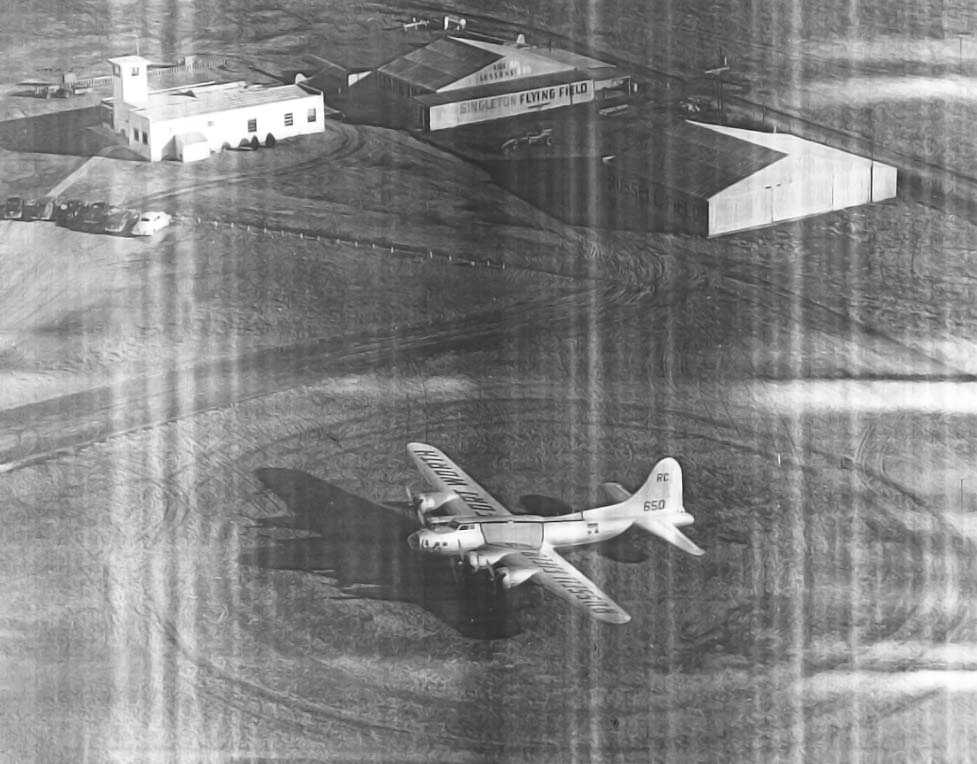
An undated (post-WW2) aerial view looking southwest at a surplus B-17G Flying Fortress bomber (43-37650) which was used for promotional purposes at Russell Field.
Note the hangar which was still painted with “Singleton Flying Field”.
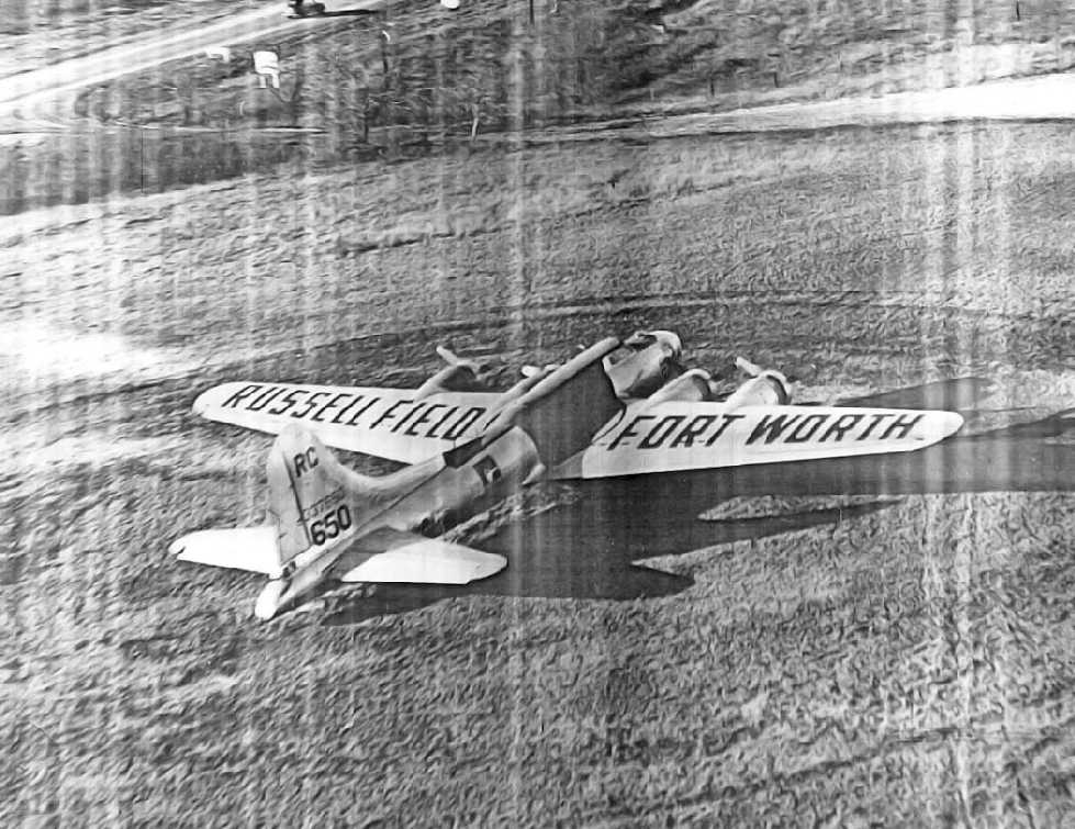
An undated (post-WW2) aerial view of a surplus B-17G Flying Fortress bomber (43-37650) which was used for promotional purposes at Russell Field.

A 2/23/46 photo of 4 women & a Beech Staggerwing at Russell Field.
The original caption: “When the Stock Show Aviation Exposition aerocade took off from Russell Field to tour the Panhandle the personnel included:
Dorothy Brandt, entertainment program director of the Recreation Department, Carmen Hinds, daughter of Mr. & Mrs. Vernon Hinds,
C.W. Wofford, official trip hostess, and Nancy McElroy, daughter of Mr. & Mrs. J. H. McElroy. Carmen & Nancy are singers & dancers.”
“Russell Airfield” was depicted on the March 1947 Dallas Sectional Chart (courtesy of Chris Kennedy).
The January 1948 Dallas Local Aeronautical Chart depicted Russell Field as having a 3,100' unpaved runway.
The 1948 USAF Target Complex Chart (courtesy of David Brooks) depicted Russell as having an irregular outline,
but it did not depict any runways or buildings.
William Hooper's 1948 receipt for an hour of flying at Russell Field (courtesy of Daryl Pokladnik) showed a charge of only $6.
Daryl remarked, “It is amazing how inexpensive it was to fly back then.”
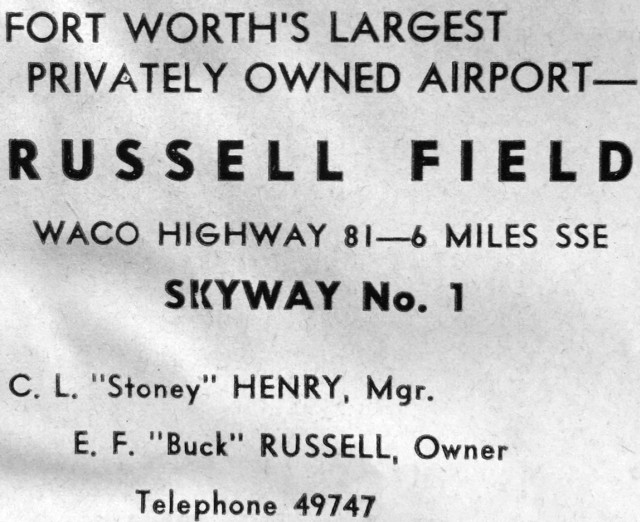
A 1948 advertisement for Russell Field (courtesy of Kevin Walsh).
According to Joel Russell, his father Tom Russell learned to fly & soloed at Russell Field in 1949.
A 4/1/52 USGS aerial view depicted Russell Field as having 3 unpaved runways, and several hangars & 2 light planes on the southwest side.
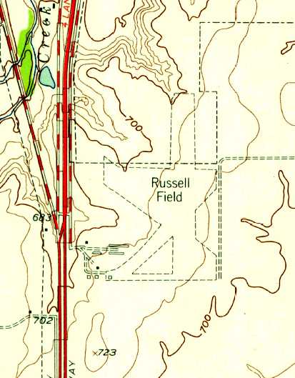
The earliest topo map depiction which has been located of Russell Field was on the 1955 USGS topo map.
It depicted Russell Field as having several unpaved runways with a few small buildings at the southwest end.
Al Pugsley recalled, “I flew off Russell Field on 3/24/56.
I received my private, commercial & instructors ratings there & a friend & I started a flying school there.
I worked for C.O. Thompson pumping gas & mowing the field.
The north end of the dirt north/south runway was hollowed out
by the prop wash from so many planes taking off to the south into the prevailing winds.”
A 1956 aerial photo depicted Russell Field as having 3 runways which appeared to be asphalt,
as well as a 4th unpaved runway, and several hangars & aircraft at the southwest side.
The September 1957 Dallas Sectional Chart (courtesy of Chris Kennedy) depicted Russell Field as having a 3,100' unpaved runway.
Tom Williams recalled, “My Dad was the owner of one of the flight schools at Russell Field from 1957-72.
I worked at the airport from 1959-68 in many capacities: gas boy, tractor operator, flight instructor and airport assistant manager.”
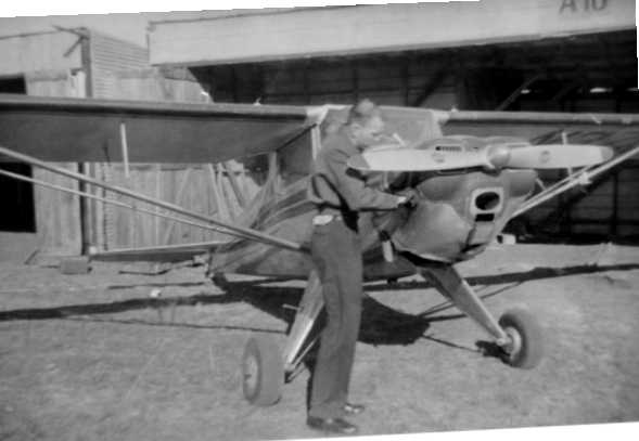
A 1958 photo of Tom Russell pre-flighting his Luscombe 8C at Russell Field (courtesy of Joel Russell).
Joel recalled, “When Dad [Tom Russell] first bought this Luscombe 8C, N37050 was kept at Russell Field.”
Bill Sievers recalled of Russell Field, "In the 1950s & into the 1960s it was a very active general-aviation airport."
Gerry Gieger recalled, "I do remember the Goodyear Blimp stopping at Russell field whenever it was in this area."
Guy Spencer recalled, “On 7/3/59 I had my first solo cross-country flight; Russell Field was my destination.
Arriving at Russell, I found the longer runway (35) X'd out due to mud. My only option was to use the 1,900' sod Runway, 22, which had an approach over trees & a building at the far end.
I did the normal left-hand pattern, passing well over the trees, but found myself floating over the runway (as Taylorcrafts were wont to do).
As the building ahead of me loomed larger, I had no choice but to power up & go around.
On my second attempt, the same thing happened. By now, there was a group of people assembling in front of the office with a clear view of my efforts.
I might have given up & headed back to Weatherford, but the float in the fuel tank was getting low. I was determined to try once again, but with a pattern 100' lower.
This time I passed much closer over the trees, and was able to get the plane on the ground. I taxied up to the gas pump in front of the office, got out, and asked for fuel. My hands were still shaking.
A gentleman came out of the office & began eyeing my somewhat ragged-looking aircraft with its numerous fabric patches.
He asked to see the aircraft documents and finally, satisfied that it was airworthy, he looked at me & asked, 'What made you decide to land on that last approach?'
I could only answer, 'Well, sir, it just felt right.' He nodded approval. I asked if he would sign my logbook.
He did, and I then realized he was O.K. Haley, the local safety officer for the CAA who just happened to be visiting the field that day.
I couldn't tell him, 'I landed because I was so low on fuel I didn't feel I had any other choice.' Maybe he figured that out.”
Ganey Bradfield recalled, “Russell Field... I have flown off it several times.
The BIG thing about it was a cliff on the north end that did a number on unsuspecting pilots landing to the south.
That cliff created a pretty good down draft that, if you weren't aware of it,
would drop you down pretty low on final approach.
One could tell if the landing pilot was unfamiliar with that feature -
he would always have to add power to get to the end of the runway.”
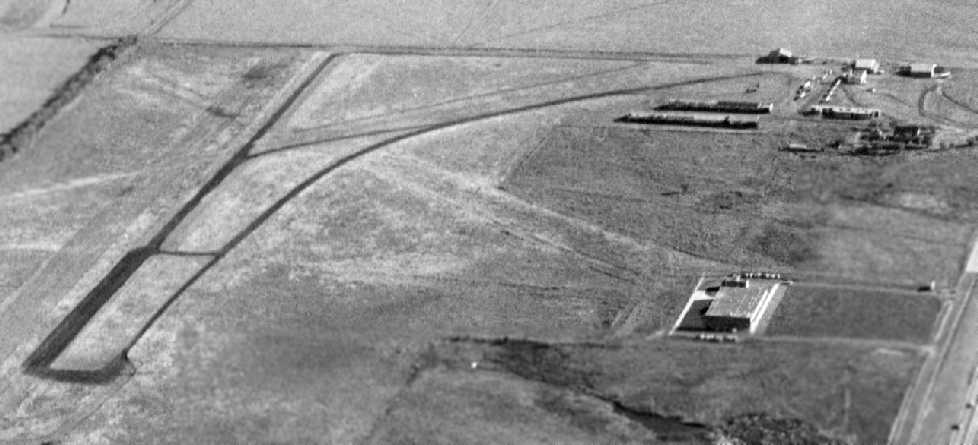
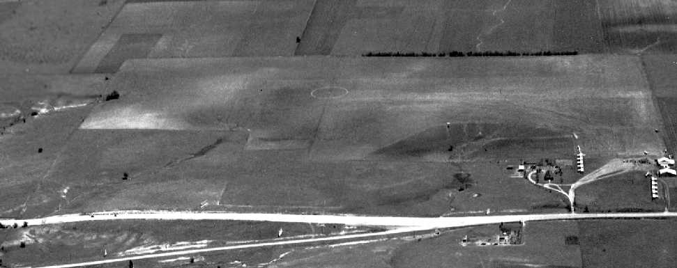
A 1959 aerial view looking southwest at Russell Field (courtesy of Jerrell Baley).
The runways & taxiways appeared to be paved in this photo, but all other information indicates the field always had grass runways.
Tom McDonald reported, “The large building on the center/west side was the first building of Alcon Laboratories. It was completed in 1959.”
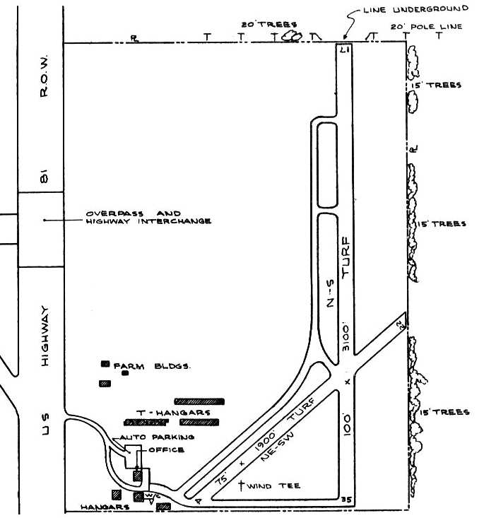
The 1963 TX Airport Directory (courtesy of Steve Cruse)
depicted Russell Field as having 2 turf runways: 3,100' Runway 17/35 & 1,900' Runway 4/22.
Each runway had a parallel taxiway, which led to a group of six hangars & an office at the southwest corner of the field.
The manager of the field was listed as O.C. Thompson, and the operators were listed as Aero Tex Maintenance, Foster Flying Service,
Fulton Flying Service, Texair Flyers Inc., and Williams Flying Service.
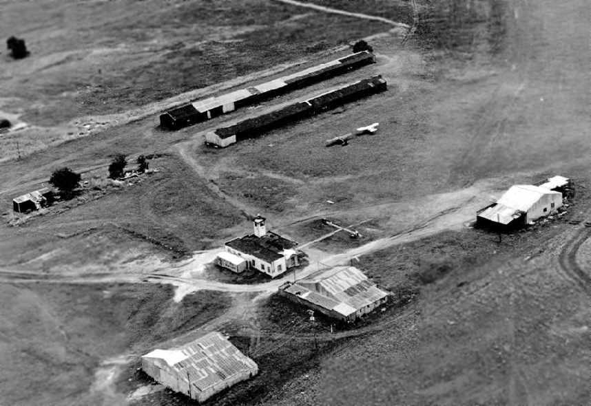
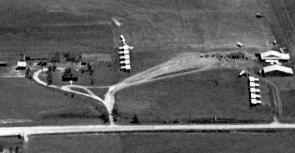
A 1964 aerial view by Ken Morris, looking northeast at Russell Field's hangars, taken from 'Hap's' Taylorcraft.
Note the control tower on top of the building in the center.
Ken recalled, “Bill Carr & I were his instructor & charter pilots.”
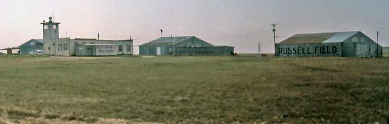
A circa 1964-69 photo by Ken Morris of Russell Field's control tower & hangars.
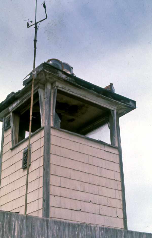
A circa 1964-69 photo by Ken Morris of Russell Field's control tower,
which appeared to be abandoned by that point, with broken windows.
Ken Morris recalled, “My 1st flying job was flying for 'Hap' Foster at Russell Field.
C.O. Williams was the check pilot that gave me my commercial license.
'Old Man' Thompson, as he was known, (manager of Russell Field)
as a good friend & a great old man rich in aviation history.”
Jim McCurdy recalled, “Hap Van Foster was the primary flight instructor at Russell Field
when I did my solo flight in 1966.”
Russell Field was described as having a 3,100' unpaved runway
in the 1967 TX Airport Directory (courtesy of Brad Stanford).
Tom McDonald reported, “I learned to fly at Russell Field in 1968. I landed on that dirt runways many times.”
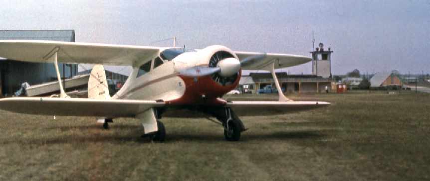
A 1969 photo by Ken Morris of a Beechcraft Staggerwing in front of the Russell Field terminal building.
The last aeronautical chart depiction which has been located of Russell Field was on the 1969 Dallas Sectional Chart.
It depicted Russell as having a 3,100' unpaved runway.
Jeff Burns recalled, "When I was growing up [late 1960s & early 1970s]
my Dad would often take us to Russell Field to watch airplanes.
Back then when the Goodyear Blimp would visit the Fort Worth area & stay overnight,
they would usually moor the blimp at Russell Field.
The entrance to Russell Field used to be south of where Alta Mesa Boulevard is now.
The hangars were just to the south of the present day Holiday Inn.
Alcon Laboratories original building was to the north [of present day Alta Mesa] next to the I-35W service road.
The two ¼ circle office towers visible in the photograph
are roughly in line with the old flight path approaching the runway.
The airport did not extend into the subdivision to the northeast.
The subdivision was existing before Russell Field closed.
I also think that the runway extended further south by the time the airport closed
[compared to what was depicted from the 1963 airport directory above].
I remember from watching the planes taxiing etc,
that my impression was that the big red wind tee that was in front of the little control tower building
seemed to be more in the middle [north/south wise] of the field rather than so far south."
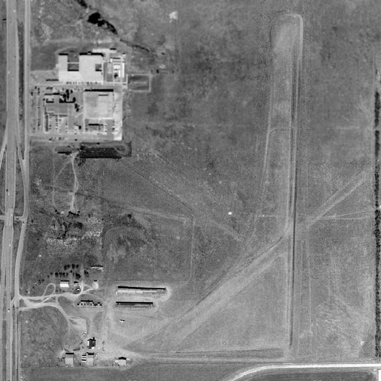
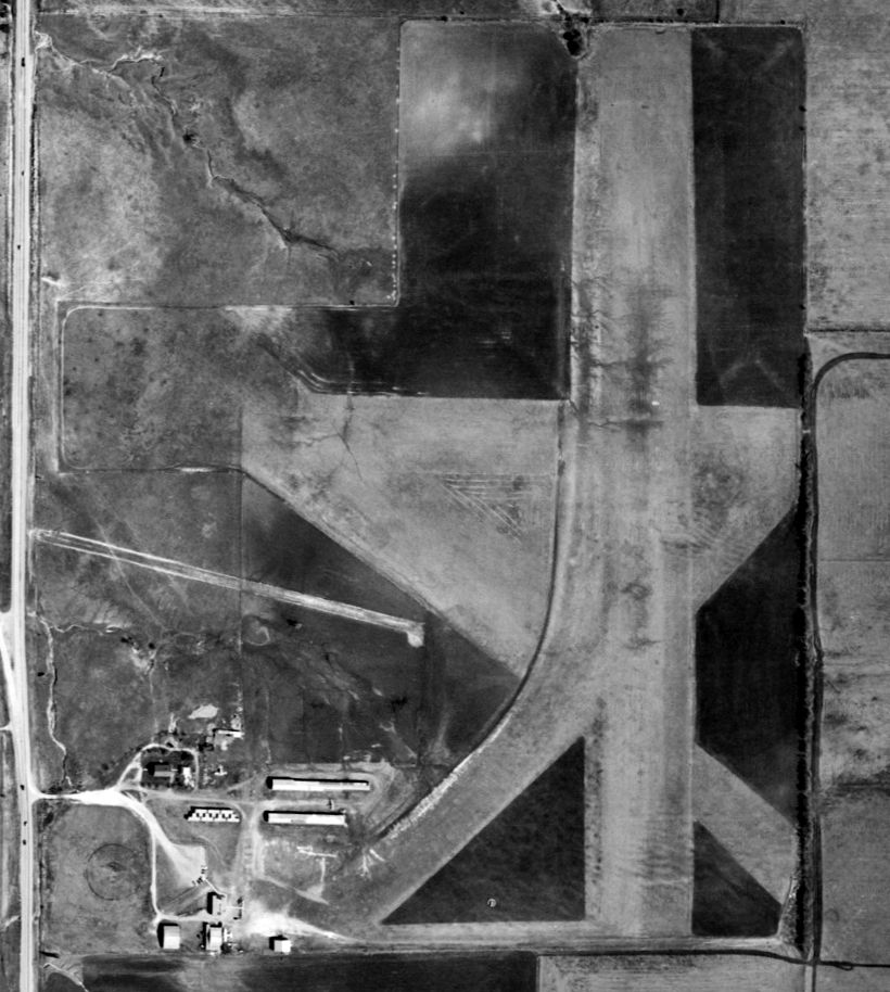
A 1970 aerial view depicted Russell Field as having 2 unpaved runways, with evidence of a 3rd grass runway.
Several hangars were located on the southwest side of the field,
but it did not appear very healthy, as only a single airplane was visible on the field.
George Horn recalled, “My 1st assignment with S & S (which also operated S & S Patrol Field) was at Russell Field.
I moved there & based a plane there for S&S in 1972. I flew Gulf Oil pipeline patrols out of there for over a year.
At the time old Col. Williams was still around, pretty frail, he was usually rocking on the front porch of the old wooden terminal.
A Mr. Foster actually ran the airport & he had a single-pilot 135 operation using an old Cessna 310 for freight mostly.
Mr. Foster was good to me & gave me a key to his shop & allowed me to use his tools & shop whenever I wanted.
In late 1973 I believe it was, I offered old Col Williams a ride in my company Cessna 140 & much to my surprise he took me up on the offer.
I had to help him into the little airplane he was so frail. I recall he insisted on keeping his cane in his lap.
All I did was take off, and fly one circuit & while on downwind I noticed he had a big grin
and he leaned over & said to me 'Well, I guess you better put me back down.'
I believe it was the old flight instructor's last airplane ride, as he died shortly thereafter.”
George Horn continued, “In the last month or so of 1973 I relocated to the home base, S&S Patrol Field near League City
as I had hired Ron Lane to replace me as the Fort Worth area pilot.
It was shortly afterwards that I learned Mr. Foster had been killed flying freight (explosives for the government).
I believe he hit a mountain somewhere.
Just before I'd moved Mr. Foster had agreed to sell me a Grumman Wigeon with Rangers which sat in one of the shade hangars.
It's engines were in crates, and the wings were also removed & crated & stored alongside as was the interior.
The price we'd agreed upon was $500.
He told me there was no hurry to pay him, as he knew I'd have to scrape to come up with it on patrol pilot's salary.
I intended it to be a long term reconstruction project,
and when I learned of his death, I returned to visit Mrs. Foster to pay her & pick up the logbooks.
I was too late. I was told the shade hangars had been bulldozed into a hole, complete with the airplane & crates of misc. spare parts.
It's all under concrete now. I believe the death of Mr. Foster was the final blow for Russell Field, as he was the last operator there.”
Russell Field was still depicted as an active airport on the 1974 Rand-McNally DFW road map.
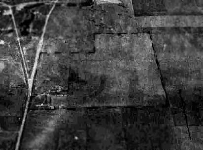
The last depiction which has been located of Russell Field was a 10/3/75 aerial view northeast (courtesy of Jerrell Baley).
Three light aircraft were still visible on the field.
Nancy Kelly recalled, “Ralph Hogue ran the flying school in 1976 – the control tower building was about the only thing left… and it was in pretty rough shape.
I started my pilot's license there in 1976 then finished at Oak Grove when Russell was bought by the brewery & closed.”
Russell Field was evidently closed at some point in 1976,
as it was no longer depicted on the 1976 DFW Terminal Chart (courtesy of Jim Hackman).
By the time of a 1979 aerial photo, the buildings & runways of Russell Field had been completely removed.
Jeff Burns recalled, "I heard stories that the Miller brewery [to the south] bought the field to expand their facilities.
It seemed that shortly after Russell Field closed,
the Miller Brewery built a building either on, or immediately off of the south end of the runway.
Later the Holiday Inn came in, then Alcon expanded [several different times] & finally Alta Mesa was cut through."
Bill Sievers recalled, "When I visited Fort Worth in 1987,
I stayed at the Holiday Inn in that general location which is just about where the airport was.
I looked around for any evidence of it which might have remained, but couldn't find any."
By the time of a 1990 aerial photo, a hotel & other buildings occupied the site of Russell Field,
and not a trace of the airfield appeared to remain.
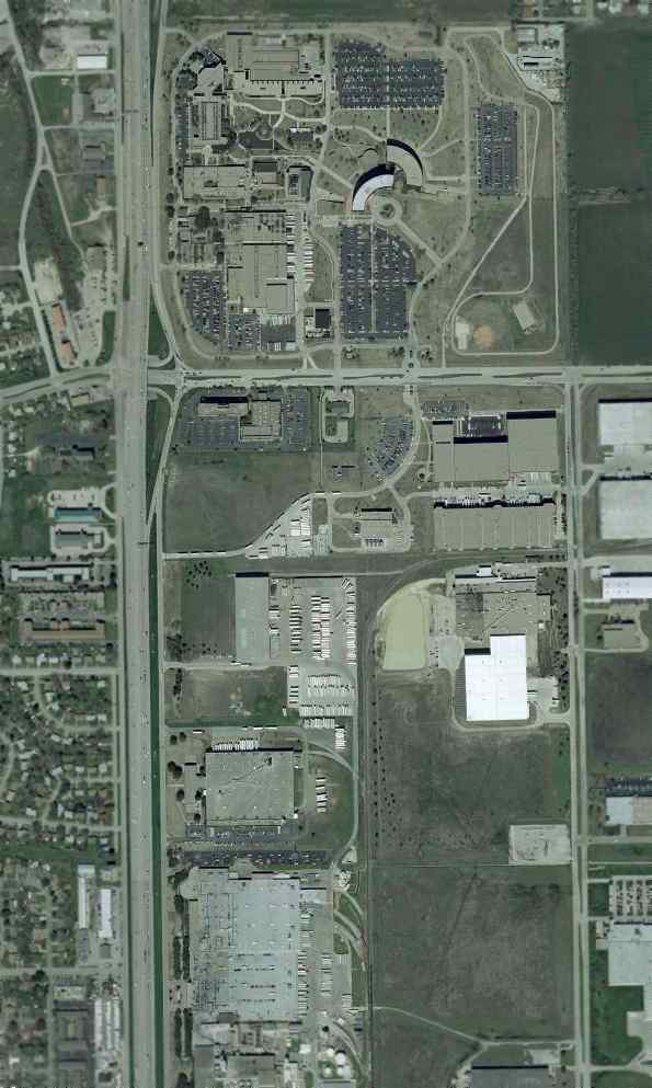
A 2001 aerial view of the site of Russell Field.
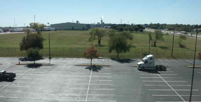
An October 2004 photo by Tim Tyler "looking south over the rear of the Holiday Inn Fort Worth South parking lot,
onto the Alcon Corporation property used for parking truck trailers, and then beyond that is the large Miller Beer brewery & distribution center.
The highway visible [on the right] is Interstate 35."
In October 2004, Tim Tyler stayed in the Holiday Inn which occupies part of the site of Russell Field.
"Unfortunately, I didn't notice any signatures whatsoever of the site having once been an airfield."
The site of Russell Field is located east of the intersection of Interstate 35 & Altamesa Boulevard.
____________________________________________________
Taliaferro Field #3 / Carruthers Field / Benbrook Field, Benbrook, TX
32.68, -97.46 (Southwest of Fort Worth, TX)
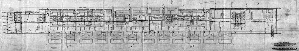
A 12/3/17 drawing showing water mains, sewer mains, roads, and sidewalks as constructed at Taliaferro Field #3 (courtesy of Bill Morris).
According to Bill Morris, “When the U.S. entered World War I on 4/6/17,
the Aviation Section of the U.S. Army Signal Corps consisted of 5 'combat' squadrons with 55 serviceable airplanes.
Three of the squadrons were stationed in the Philippines, Hawaii, and the Panama Canal Zone.
At a meeting in Washington DC in May 1917, the Royal Flying Corps Canada agreed to immediately begin training 300 pilots
and enough ground support personnel to organize 10 squadrons for the U.S. Army Air Service.
In return, the U.S. Army would construct a site in the U.S. for RFC Canada to use for training during the winter months.”
Bill continued, “In June, the War Department inspected 6 sites around Fort Worth which had been offered by the Chamber of Commerce
and by July, RFC Canada inspected 5 potential sites in Texas & Louisiana for use during the winter.
In August, the War Department signed leases on 3 sites around Fort Worth & construction began in late August & early September.”
Bill continued, “The 3 flying fields around Fort Worth were locally referred to as Hicks (located at Hicks Station on the Fort Worth & Denver City Railroad),
Everman, and Benbrook based on their locations.
In September 1917, the Army initially named the fields Jarvis (Hicks), Edwards (Everman), and Taliaferro (Benbrook).
When RFC Canada selected the 3 fields around Fort Worth,
the Army & the RFC established Camp Taliaferro in Fort Worth to direct the activities of the 3 fields
and designated them Taliaferro Field #1 (Hicks), Taliaferro Field #2 (Everman) and Taliaferro Field #3 (Benbrook).
The Camp Taliaferro offices for the US Army Air Service & RFC Canada were initially located in the basement of the Chamber of Commerce building
to handle pay, purchasing, and administrative services for their own personnel assigned at the three fields.”
The earliest depiction which has been located of Taliaferro Field #3 was a 12/3/17 drawing showing water mains, sewer mains, roads, and sidewalks (courtesy of Bill Morris).
According to Bill Morris, “The field initially included 12 hangars & the hospital on the far right had 3 wings.”
According to Bill Morris, “Following the departure of the Royal Air Force in April 1918 (the Royal Flying Corps was renamed on 4/1/18),
Camp Taliaferro was closed & each of the 3 fields operated as separate sites.
On 4/16/18, the fields were formally renamed Taliaferro Field (Hicks), Barron Field (Everman) and Carruthers Field (Benbrook).
The 3 airfields around Fort Worth were part of a larger effort to increase pilot training for the US Army Air Service.
Barron Field & Carruthers Field were 2 of the 14 newly-constructed fields for primary pilot training.
Taliaferro Field was the first of 4 aerial gunnery schools established by the Air Service
who relied heavily on the RFC Canada School of Aerial Gunnery to get their gunnery training program 'off the ground'.”
An undated (WW1 era) map hand-drawn by Gus Benneke for the WW1 pilot trainees out of Love Field
who used the 3 Taliaferro Fields (from The Frontiers of Flight Museum, courtesy of Knox Bishop).
According to Bill Morris, “In all, 28 new flying fields were constructed between late 1917 & early 1918
to support primary pilot training; aerial gunnery; and pursuit, observation & bombardment training programs.
Each field was laid out & constructed using a standard set of blueprints prepared by Albert Kahn, a Detroit architect.
Each field required 4 million feet of lumber & cost approximately $1 million.”
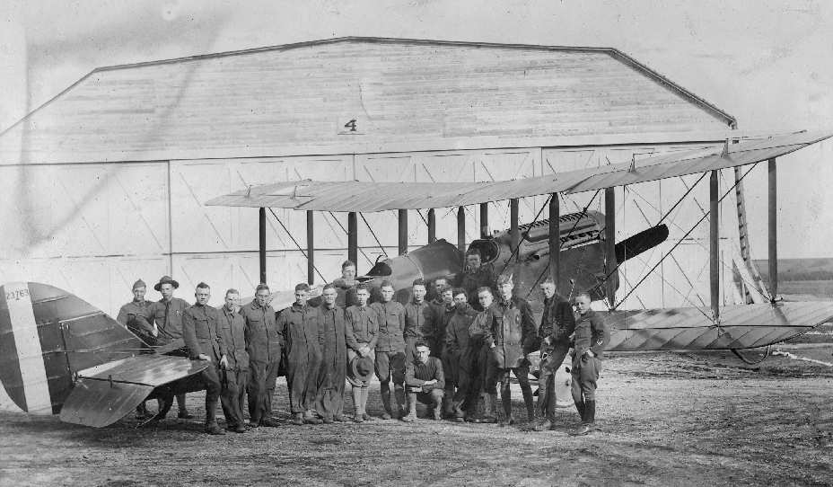
A WW1 era view looking west at Taliaferro Field #3 from the water tower, taken by Sgt. Christopher Devos, #84 Canadian Training Squadron, while stationed in Benbrook
(from the Sgt C. P. Devos Collection, Deseronto Archives, Ontario, via Bill Morris).
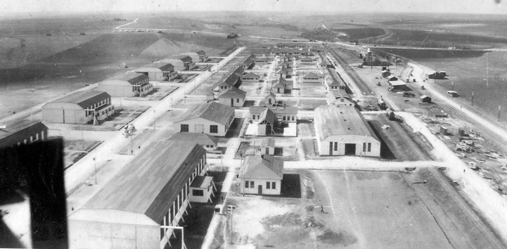
An undated aerial view of the hangars of Benbrook Field (from the Benbrook TX Public Library, via Corky Baird).
An undated photo of a group in front of a DH-4 biplane & hangar at Benbrook Field (from the Benbrook TX Public Library, via Corky Baird).
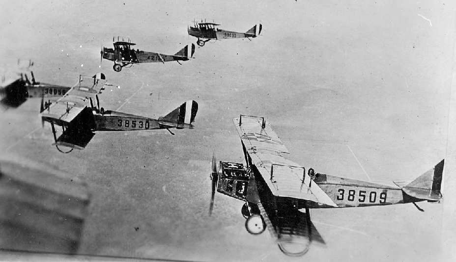
An undated aerial view of a formation of biplanes from Benbrook Field (from the Benbrook TX Public Library, via Corky Baird).
Bill Morris observed, “This photo was taken some time after January 1918
when the Air Service briefly adopted the British & French roundel insignia to provide some type of uniform markings for allied aircraft.
AS 38530 has the roundel design, while AS 38509 has the star insignia.”
One particular Royal Flying Corps aviator, Captain Vernon Castle,
was already world renown as the famed dance team of Vernon & Irene Castle.
Regrettably, he was killed in a plane crash at Benbrook on 2/15/18.
The student pilot & Castle's pet monkey 'Jeffrey' survived the crash.
Some witnesses, including William Fuller,
believed that he deliberately crashed in order to avoid hitting another plane, and saved their lives.
His funeral was witnessed by thousands of mourners,
who sadly watched the flagged draped casket pass in downtown Fort Worth.
Even today, there is a street in Benbrook named in his honor.
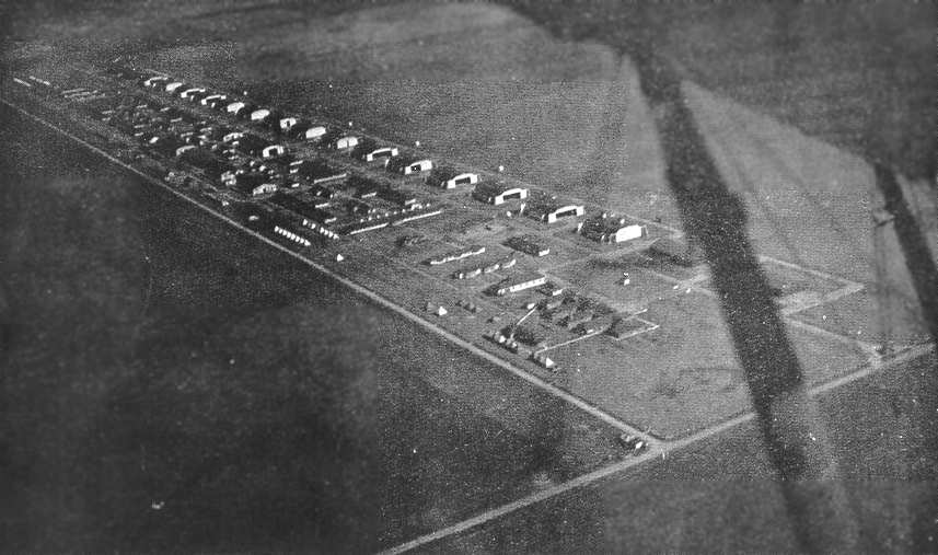
A 1918 aerial view looking north at Carruthers Field (courtesy of Benbrook Public Library, via Bill Morris).
Bill Morris observed, “ The road on the right is present-day Winscott Road in Benbrook. The 3 concrete silos located in the left-center still exist.”
A 1918 overhead view of Benbrook Field (from the Benbrook TX Public Library, via Corky Baird).
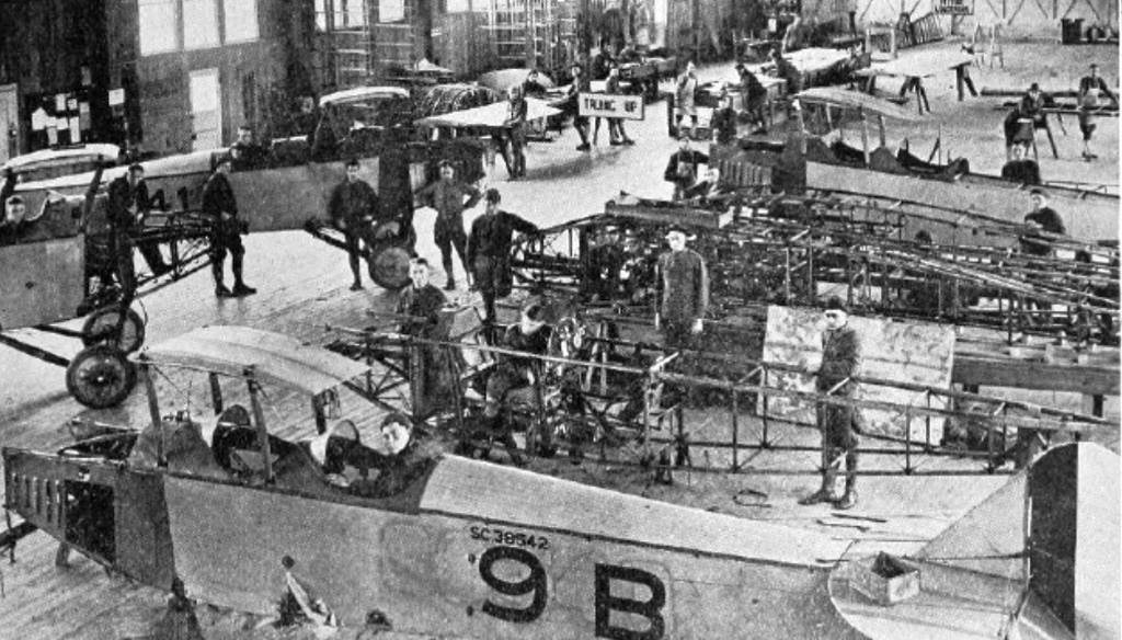
Benbrook Field consisted of a grass landing area alongside of which were arrayed an amazing total of 16 hangars.
The buildings & hangars were oriented east/west on the north side of the flying field.
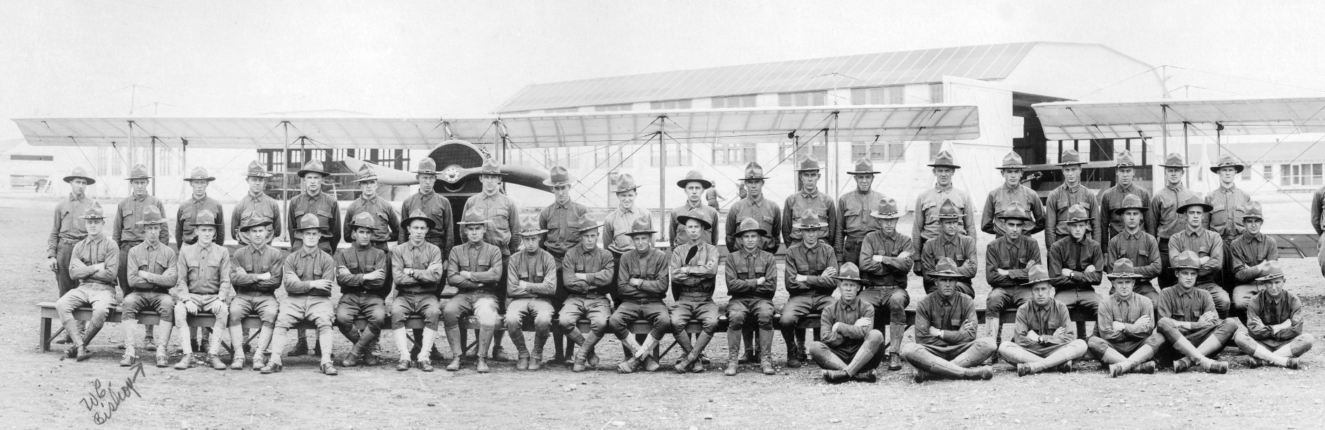
A 1918 photo of student pilots in front of several biplanes & hangars at Carruthers Field (courtesy of Ernie Feil, whose grandfather Walter Bishop is 1st row, 2nd from left).
Benbrook was not depicted on the 1918 USGS topo map.
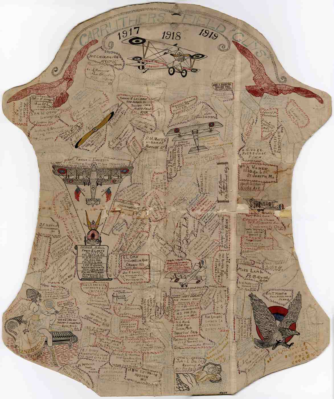
A photo (courtesy of Rose Wood) of what Steve Messenger reported is “a piece of biplane canvas, mounted on cardboard.
[It] contains an ink drawing of an early airplane & names of the U.S. Army soldiers, including my Grandfather, Clare Messenger.
The title reads: Carruthers Field Boys 1917 1918 1919.
I was able to donate it to the WW1 Museum in Kansas City.”
Rose Wood reported, “My great grandfather Raymond John Rodger was sent to Carruthers in October 1918.”
Benbrook Field was deactivated in September 1919
and was sold at auction to William Monnig, President of the Fort Worth Chamber of Commerce, in January 1920 for $43,500.
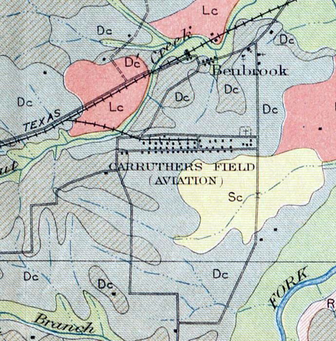
A 1920 Agriculture Department Soil Map depicted “Carruthers Field (Aviation)” (courtesy of Randy Gilbert).
By 1932, Benbrook Field was no longer depicted at all on the Dallas Sectional Chart.
Benbrook was evidently was not reused during WW2.
It was not depicted on the 1945 USGS topo map.
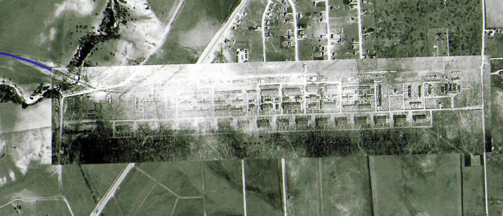
The 1918 Carruthers Field aerial photo overlaid by Bill Morris on a 1952 USGS aerial photo.
Bill observed, “The [blue] line shows the location of the railroad spur which connected the field to the T&P Railroad.
Some of the building & hangar foundations were still visible on the 1952 photo.
The road on the right is Winscott Road & the diagonal highway is US 377.
The road between the hangars & the buildings is now Cozby North Street.”
By the time of a 1956 aerial photo, there were no recognizable traces of Benbrook Field,
with the site having been mostly redeveloped with housing.
However, John Wilson recalled, “I moved to a brand new house at 1010 Usher Street in 1956.
I lived there until 1964. As a child there, my siblings & I explored almost every square inch of the Benbrook area.
We had found & identified ruins of some of the structures used by the airfield without knowing exactly what they were.
We played around at a foundation with a basement, usually full of water & tadpoles, on the north side of Cozby South Street,
which I recognize in the 1918 photo as a small building just west of Usher Street.”
Bill Morris reported, “There were no basements in any of the buildings other than small 'valve pits'
generally in one corner of the building for water & sewer lines.
The site in question may have been the 15,000 gallon water storage cistern which was located near the water tower.”
As seen in the 2002 USGS aerial view, the site of Benbrook Field has been mostly redeveloped with housing.
A 2003 photo by Scott Murdock of the memorial to the fliers of Benbrook Field.
Bill Morris observed, “This is a photo of the school yard at Benbrook Elementary School.
The area was occupied by the married officers' quarters & the officers' club”
According to Bill Morris, “The northeast corner of the field was located at the intersection of Mercedes Street & Winscott Road.”
According to Bill Sievers, "If you look beside one of the houses there, I believe on John Reagan Street,
you can see a large concrete apron which the owner uses a patio.
I was told this was where one of the hangar buildings was located.
About a mile south of there, near one of the neighborhood's water tanks,
there is a memorial plaque which describes the airfield."
According to Bill Morris, “The buildings at Carruthers Field occupied the area bounded by Mercedes Street on the north
and Cozby North Street on the south.
The hangars were located on the south side of Cozby North Street.
The eastern edge of the flying field is Winscott Road & the western edge extended to the west of US 377.”
David Martin reported in 2004, "I live about 200-300 yards west of the eastern edge of what was the field.
There are some of what appears to be remaining concrete slab areas
in a very few back yards along Cosby North Street here. I have seen them.
Homeowners in that area say that they have been told those are remnants of the old airfield.
There is also in a very small undeveloped area just north of Cosby North Street & south of Mercedes Street
a thing which I guess is a possible cistern from the field.
There is one remaining building in a field west of US 377 South
(although as a police officer here in Benbrook I can not say people should go out there as it is trespassing).
I have been out to that building several times as we have used it for tactical training.
It is what I believe is a munitions building
and seems to be of the same construction as the one remaining building at Barron Field.
The walls of both buildings are extremely thick."
David continued, "The memorial at Benbrook Field is for the famous dancer Vernon Castle [who died in a crash at Benbrook].
The memorial had fallen into disarray but was restored by local Eagle Boy Scout Jarrod Martin
as his service project a few years ago.
It was roughly 1998 or 1999 when he did this.”
Although other reports had indicated the memorial was located at the crash site,
Bill Morris reported, “The monument is located 3,100' south of what would have been the western end of the row of hangars -
in the extreme southwest corner of the flying field.
Photos indicate the crash site was closer to the hangars & somewhere near the middle of hangar row.”
The 1918 photo of Beenbrook Field overlaid by John Wilson over a 6/12/11 aerial view.
John was able to determine that the row of hangars was located along the south side of the present-day location of Cozby Street,
extending from just west of Route 377 eastward to the intersection of Winscott Road.
Bill Morris reported in 2013, “The munitions building in Benbrook was bulldozed into oblivion several years ago to make room for a Wal-Mart Super Center.
So much for preserving our aviation heritage. I can be critical - I live in Benbrook.”
See also: The Handbook of TX Online.
____________________________________________________
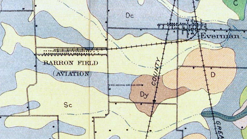
Taliaferro Field #2 / Barron Field, Everman, TX
32.62, -97.31 (South of Fort Worth, TX)
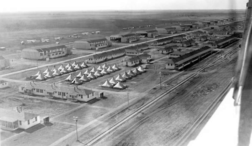
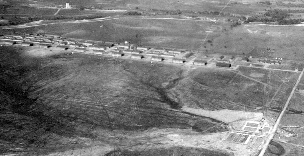
An aerial view looking southwest at Barron Field, probably late 1917 or early 1918 due to the number of tents on the site (courtesy of Bill Morris).
According to Bill Morris, “Barron Field was one of 3 fields in the Fort Worth area
which were used by the U.S. Army Air Service to conduct flight training during the First World War (the other 2 fields were Taliaferro Field & and Carruthers Field).
The Royal Flying Corps Canada used the field for primary pilot training from November 1917 to April 1918.”
Bill continued, “When the U.S. entered World War I on 4/6/17,
the Aviation Section of the U.S. Army Signal Corps consisted of 5 'combat' squadrons with 55 serviceable airplanes.
Three of the squadrons were stationed in the Philippines, Hawaii, and the Panama Canal Zone.
At a meeting in Washington DC in May 1917, the Royal Flying Corps Canada agreed to immediately begin training 300 pilots
and enough ground support personnel to organize 10 squadrons for the U.S. Army Air Service.
In return, the U.S. Army would construct a site in the U.S. for RFC Canada to use for training during the winter months.”
Bill continued, “In June, the War Department inspected 6 sites around Fort Worth which had been offered by the Chamber of Commerce
and by July, RFC Canada inspected 5 potential sites in Texas & Louisiana for use during the winter.
In August, the War Department signed leases on 3 sites around Fort Worth & construction began in late August & early September.”
Bill continued, “The 3 flying fields around Fort Worth were locally referred to as Hicks (located at Hicks Station on the Fort Worth & Denver City Railroad),
Everman, and Benbrook based on their locations.
In September 1917, the Army initially named the fields Jarvis (Hicks), Edwards (Everman), and Taliaferro (Benbrook).
When RFC Canada selected the 3 fields around Fort Worth,
the Army & the RFC established Camp Taliaferro in Fort Worth to direct the activities of the 3 fields
and designated them Taliaferro Field #1 (Hicks), Taliaferro Field #2 (Everman) and Taliaferro Field #3 (Benbrook).
The Camp Taliaferro offices for the US Army Air Service & RFC Canada were initially located in the basement of the Chamber of Commerce building
to handle pay, purchasing, and administrative services for their own personnel assigned at the three fields.
Following the departure of the Royal Air Force in April 1918 (the Royal Flying Corps was renamed on 4/1/18),
Camp Taliaferro was closed & each of the 3 fields operated as separate sites.”
Bill continued, “On 4/16/18, the fields were formally renamed Taliaferro Field (Hicks), Barron Field (Everman) and Carruthers Field (Benbrook).
The 3 airfields around Fort Worth were part of a larger effort to increase pilot training for the US Army Air Service.
Barron Field & Carruthers Field were 2 of the 14 newly-constructed fields for primary pilot training.
Taliaferro Field was the first of 4 aerial gunnery schools established by the Air Service
who relied heavily on the RFC Canada School of Aerial Gunnery to get their gunnery training program 'off the ground'.”
An undated (WW1 era) map hand-drawn by Gus Benneke for the WW1 pilot trainees out of Love Field
who used the 3 Taliaferro Fields (from The Frontiers of Flight Museum, courtesy of Knox Bishop).
Bill continued, “U.S. Air Service units were stationed at Taliaferro Field #2 in November 1917,
while the RFC Canada was here - the RFC was in charge of the flying training program.
On 4/16/18 the facility was renamed Barron Field for Cadet Robert Barron, who was killed at Chandler Field in Pennsylvania on 8/22/17.
Barron Field covered over 1,600 acres (you can’t always believe what you read on historical markers!)
and housed as many as 150 officers & and 900 enlisted men at the time of the Armistice in November 1918.
Between November 1917 - April 1918, Barron Field was home to #42 Wing, Royal Flying Corps Canada,
and continued to train RFC & American cadets & support personnel who had started training in Canada before moving to Texas for the winter.
Additional American cadets were added to the training program while they were at Taliaferro Field #2.
Number 42 Wing consisted of the 78th, 79th, 80th, 81st, and 82nd Canadian Training Squadrons.
During that time, the field was home to almost 2,000 people.”
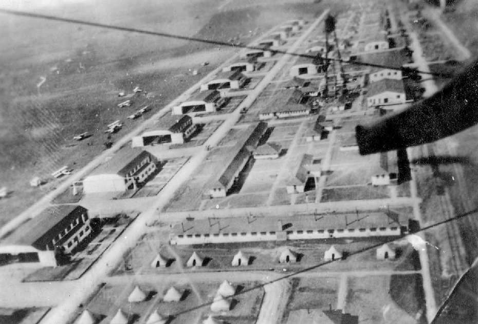
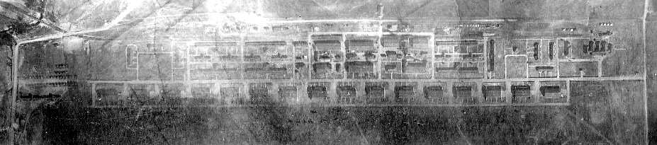
A 1918 aerial view of Barron Field (courtesy of Bill Leary) showing an amazing lineup of no less than 17 hangars.
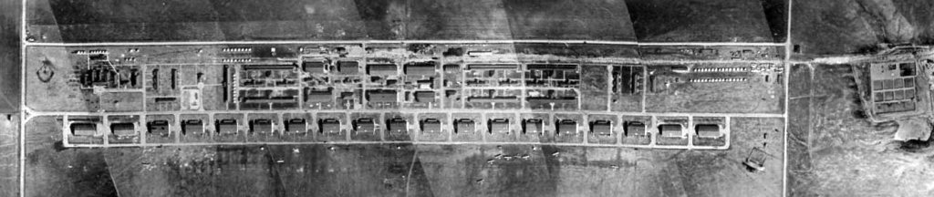
A 1918 aerial photo mosaic of Barron Field (courtesy of Bill Morris).
Bill Morris observed, “The buildings were oriented east-west on the north side of the flying field.”
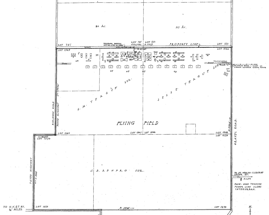
A 1/5/18 property map prepared by the Supply Division of the U.S. Army Signal Corps (courtesy of Bill Morris) shows the extent of the land area of the field.
Bill Morris observed, the “overall dimensions were slightly more than one mile square.”
According to an accident report (courtesy of Robert Carter),
Flying Cadet Franklin Fairchild was killed in a 2/23/18 crash of his airplane at "Taliaferro Field #2, Everman".
According to Bill Morris, “Between November 1917 - April 1918, 6 RFC personnel died at Barron Field due to aircraft accidents & other causes.
Thirty three U.S. Army Air Service personnel died at Barron Field between November 1917 - July 1919 when flying operations ceased.
Most were due to aircraft accidents.”

A 4/22/18 map (from the National Archives, courtesy of Arthur Sevigny).depicted Barron Field as having a row of 15 hangars.
A circa late 1918 photo of the Barron field aero repair shop (courtesy of Bill Morris).
According to Bill Morris, “By that time, all aircraft at the 3 fields around Fort Worth were identified by numbers and a letter, in this case 'B' for Barron Field.”
Barron Field was not depicted on the 1918 USGS topo map.
According to a historical marker, “Barron Field sent 6 Air Squadrons to France before the war ended, [on] 11/11/18.”
An undated (circa 1918-19) photo of Walter Wiley in front of a JN-4 Jenny at Barron Field (courtesy of Mike Cole).
Mike Cole reported, “My Great-Great Uncle's discharge papers dated 3/27/19, shows he was discharged at Barron Field, Everman, TX.
According to Bill Moris, “In late 1919 Barron Field went into 'caretaker status' & was used as a site for disposal of Air Service equipment, including surplus Curtiss JN-4s.
The City of Fort Worth attempted to lease part of the field for an industrial park because it had buildings, power, water, and a railroad spur.”
A 1920 Agriculture Department Soil Map depicted “Barron Field (Aviation)” (courtesy of Randy Gilbert).
According to Bill Moris, “The Air Service put Barron Field on their U.S. Army Airways system to support cross-country flights,
but when Fort Worth failed to make the necessary upgrades, the site was dropped in 1924.
Fort Worth returned to the Army Airways system in 1925 when the city opened a new municipal airport, Meacham Field, north of downtown.”
The Barron Field property reverted to farm land.
By 1932, Barron Field was no longer depicted at all on the Dallas Sectional Chart.
Barron was evidently was not reused during WW2.
It was not depicted on the 1945 USGS topo map.
A 1952 aerial photo of the Barron Field site (courtesy of Bill Morris).
Bill Morris observed, “The 3 white shapes in the center of the photo were the cement floors of the garage, aircraft engine test facility, and the machine shop.
The foundation of the aero repair building is discernible to the west of the machine shop, just below the small house/building.
Foundation outlines of most of the hangars are visible & 2 still have their cement floors largely intact.
The remains of the sewage treatment ponds are visible on the right.
The road across the top is now Everman Parkway & the one on the left is Interstate 35W.”
A 1956 aerial photo showed the remains of the foundations of several of the row of Barron Field hangars.
A 1963 aerial photo showed that several buildings had covered the western portion of the remains of the row of Barron Field hangars.
A 1970 aerial photo showed no significant change at the site of Barron Field.
A 1979 aerial photo showed that several buildings had covered the eastern portion of the remains of the row of Barron Field hangars,
but remains of the middle portion of the hangar foundations were still recognizable.
A 1990 aerial view no longer showed any trace of the remains of the Barron Field hangar foundations.

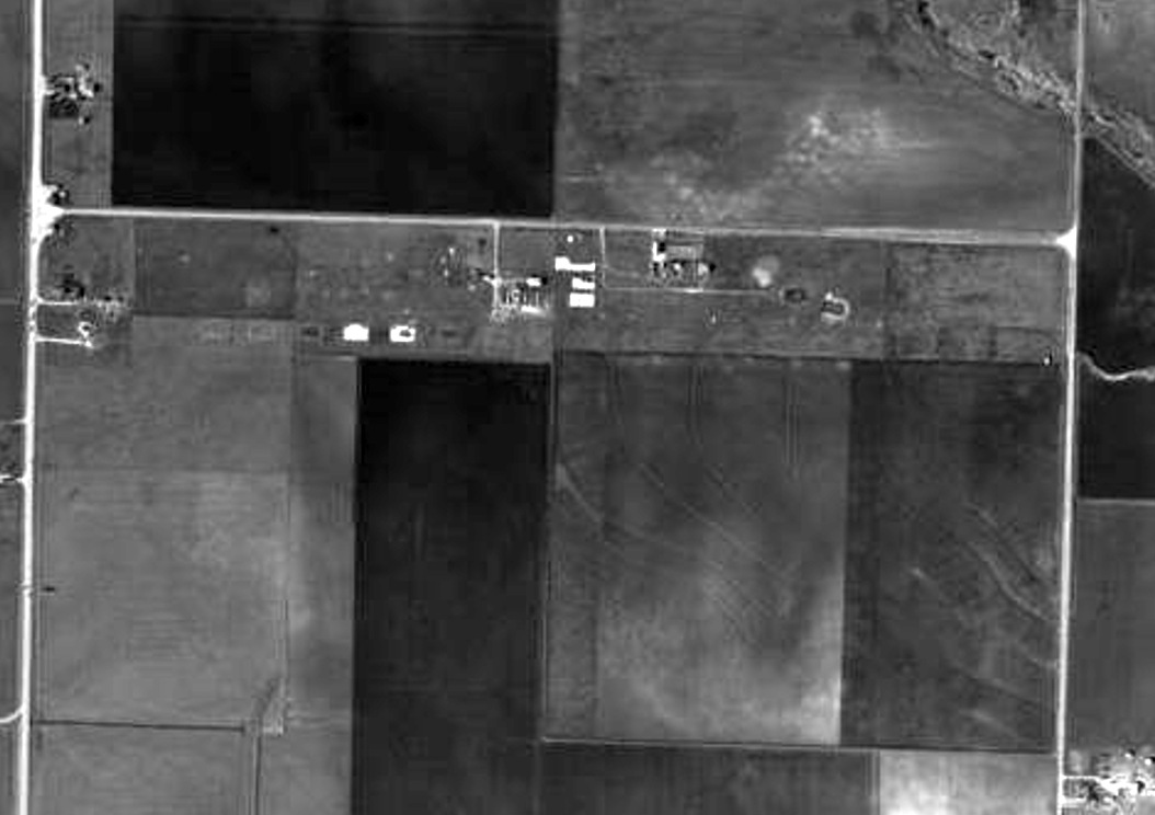
A 2001 aerial view of the north portion of the Barron Field site.
Bill Morris observed, “The small building near the upper right corner, just to the left of the road, was the munitions building and was located on the eastern edge of the field property.
The wooded area in the upper left has remains of the foundation of the aero repair building.”
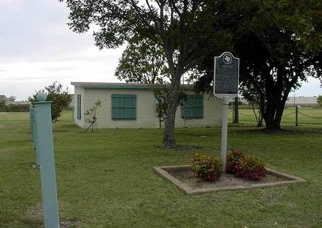
A 2003 photo by Scott Murdock of the historical marker & sole remaining building at Barron Field.
According to Bill Sievers, "There is still an old building with a historical marker
which explains what activities were engaged in at that airfield during WW1.
If it wasn't for the old building & historical marker, one would never know there was once a flying field there."
Benbrook resident David Martin reported in 2004, "The remaining building at Barron Field was maintained for years by my mom's garden club
and we strongly believe it was the munitions building for that field.
The walls of both buildings [at Barron Field & Carruthers Field] are extremely thick.
My mom's garden club donated the building to the Everman school district a few years ago
and the district was talking about making it into a small museum for their students.
I don't know where that project stands or if the district followed through or not."
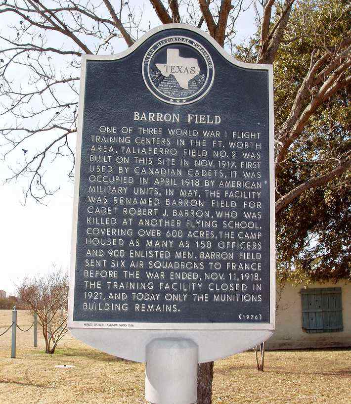
A 1/25/10 photo of the historical marker placed in 1976 at the site of Barron Field.
Jim Ireland reported in 2013, “Barron Field... I have walked on some of the hangar floors recently,
and I have also walked on the [other] foundations. They are hidden in the brush now.”
Bill Morris reported, “The only buildings with concrete foundations were the hangars, aero repair, the garage,
machine shop, blacksmith shop, and the aero & quartermaster supply buildings.
All the other buildings were pier & beam foundations.”
A 2019 aerial view looking northwest at the site of Barron Field.
The site of Barron Field is located at the intersection of Forum Way & Barron Way, appropriately enough.
____________________________________________________
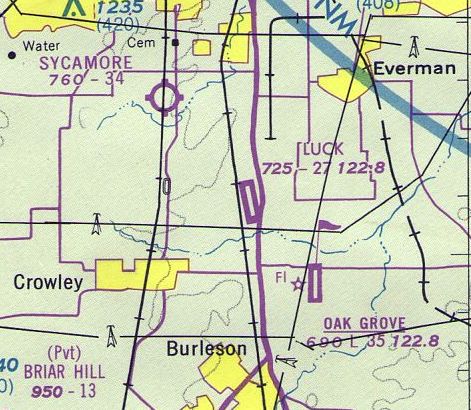
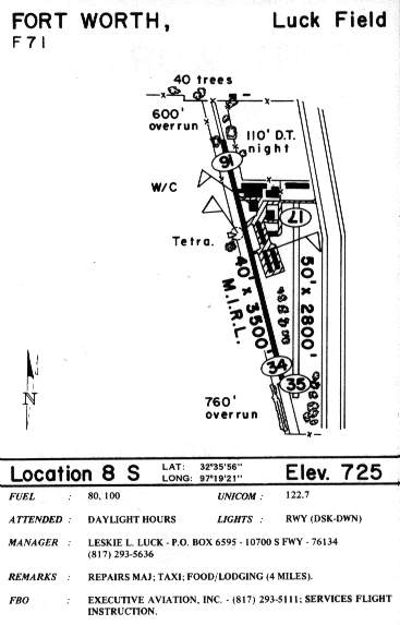
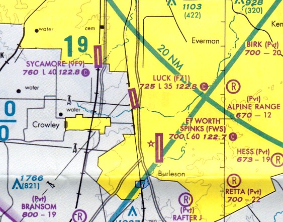
Luck Field (F71), Garden Acres, TX
32.6, -97.323 (South of Fort Worth, TX)

A 12/28/58 photo of winning skydivers Bill Cassin & Al Dillashaw at Luck Field.
This general aviation airfield was apparently built at some point before 1956.
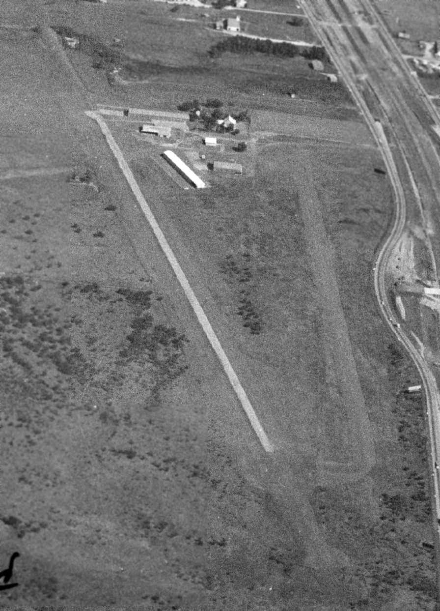
The earliest depiction of Luck Field which has been located was a 1956 aerial photo,
which depicted the field in its earliest stages, consisting of a single unpaved north/south grass runway,
with a few small buildings on the northwest side.
According to former Luck Field pilot Roger Mullins, “The airport was built by a Mr. Luck (founder of Luck Optical) and he had a beautiful home on the field.
Mr. Bill Knight ran the flight school & repair shop there. Mr. Knight had a partner in a few planes. His name was Mr. Guftafson.
He was a retired Air Force pilot who had flown B-52s in Vietnam.”
Luck Field was not yet depicted on the 1955 USGS topo map nor the September 1957 Dallas Sectional Chart (courtesy of Chris Kennedy).
The earliest depiction which has been located of Luck Field was a 12/28/58 photo of skydivers Bill Cassin & Al Dillashaw.
An article described a parachutist meet at Luck Field: “No Accident Mars Meet of 'Chutists.
A 2-day parachute meet sponsored by the Fort Worth Skydivers Club ended Sunday afternoon with a perfect safety record.
Twenty-seven jumps were made Sunday. Al Dillashaw of the Houston Parachute Club won 1st place in the 2,300' spot jump.
He landed 75' off the mark. Bill Cassin, 27, of the University of TX Parachute Club, was named best in the 20-second free-fall event for form.
He also was closest to mark in the event - 230' off from 5,500'. The meet was staged at Luck Field, 10 miles south of the city.
Practice jumps were made Saturday, contest tries Sunday. Gilbert said there were no accidents of any kind.”
A 1963 aerial photo showed that Luck Field had gained a paved northwest/southeast runway on the west side of the field at some point between 1955-63,
along with some additional buildings/hangars.
The earliest aeronautical chart depiction of Luck Field which has been located was on the July 1963 DFW Local Aeronautical Chart (courtesy of Ken Morris).
It depicted Luck as having a 3,500' hard-surface runway.
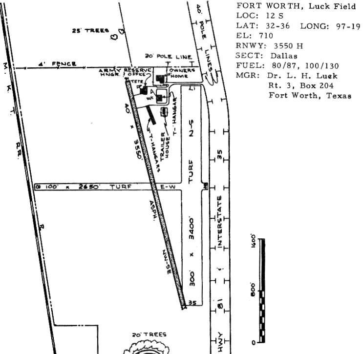
The 1963 TX Airport Directory (courtesy of Steve Cruse) depicted Luck Field as having a single 3,350' asphalt Runway 16/34,
as well as 2 turf runways: 3,400' Runway 17/35 & 2,650' Runway 8/26.
A total of 4 hangars were clustered northeast of the runway.
The field apparently also had some military use, as one building is labeled "Army Reserve Hangar & Office".
The manager was listed as Dr. L.H. Luck.
Roger Latham recalled, “Luck Field was where I soloed my first plane, an Aeronca Champ in 1964, I was 17; loads of fun.”
Steve Pittman recalled, “My father, Isham Pittman & his partner, John Freeman, [started] Eagle Flying Service around 1965 with about 5 small planes & a flight school.
John Freeman passed away about a year later & my Dad bought out his widow.”
A 1966 photo (courtesy of Steve Pittman) at Luck Field of Isham Pittman & John Freeman with their original lineup of planes,
Mooney Mite, 2 Cherokees, & 2 Cessnas, taken in front of the offices & large hangar.
The earliest topo map depiction which has been located of Luck Field was on the 1968 USGS topo map.
Curiously, the field was not labeled at all, even though it depiction 2 unpaved runways & several buildings on the northwest side.
Steve Pittman recalled, “My father, Isham Pittman built Eagle Flying Service up & it was booming by the time he sold out to investors in about 1969.
He had over 20 planes & 1 helicopter when he sold out. Those were memorable years for a young boy of 7-10 years old.
I don’t remember the east/west turf runway being used much.
Our flight instructor, whose name escapes me, loved to do acrobatics.
Unfortunately, the flying fad fizzled out within a year or so & Eagle Flying Service closed its doors.”
The earliest aerial view that has been located of Luck Field was a 1970 aerial photo.
It depicted Luck Field as having 1 paved northwest/southeast runway & 1 unpaved north/south runway.
The previous east/west runway appeared to have been abandoned.
A total of 7 aircraft were visible around the hangars on the northeast side of the field.
By the time of the 1970 TX Airport Directory (courtesy of Ray Brindle), the runways at Luck Field had started to shrink.
The paved Runway 16/34 was shortened to 3,000', turf Runway 17/35 was also shortened to 3,000', and the former turf Runway 8/26 had been closed.
A 10/3/75 aerial view looking north at Luck Field (courtesy of Jerrell Baley)
showed the field to have one paved runway & one grass runway, with several hangars at the north end.
No planes were visible on the field.
The July 1976 DFW Terminal Chart (courtesy of Jim Hackman) depicted Luck as having a 2,700' paved runway.
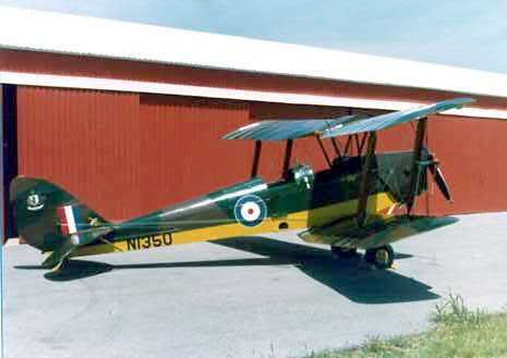
A 1979 photo of a vintage Tiger Moth biplane in front of a Luck Field hangar.
A 1980 photo of a 1950 Cessna 195 at Luck Field.
The 1982 AOPA Airport Directory (courtesy of Ed Drury) described the runway configuration of Luck Field in basically the same manner.
In the diagram of Luck Field in the 1985 TX Airport Directory (courtesy of Steve Cruse), the number of hangars had increased to eight.
The manager was listed as Leskie Luck, and the operator was listed as Executive Aviation Inc., which provided flight instruction.
Roger Mullins recalled of Luck Field, “I soloed there in 1992 & earned my private license also in 1992.
My instructor's name was Tony Mensink,
a chap from Holland that came to the U.S. to learn to fly, build time, and whose goal was to fly for KLM.
[The airport's founder's] widow still lived in the house when I started flying there in 1992.”
James McKeown recalled, “Luck Field... I remember seeing a handful of aircraft out there, and the landing strip was regularly used.
My friend Steve & I drove out there in his truck to the refueling station (summers of 1992-94)
with several 10 gallon gas cans (usually Friday or Saturday afternoons), and filled the cans up.
The attendant there never asked us what we were using it for
(probably because he knew then the airport was in a downhill direction operationally & would eventually close, or just didn't flat out care).
Steve made good use of the 'gasoline with a performance number of 110' in his 12:1 compression 454-powered 1968 Camaro at the nearby dragstrip!”
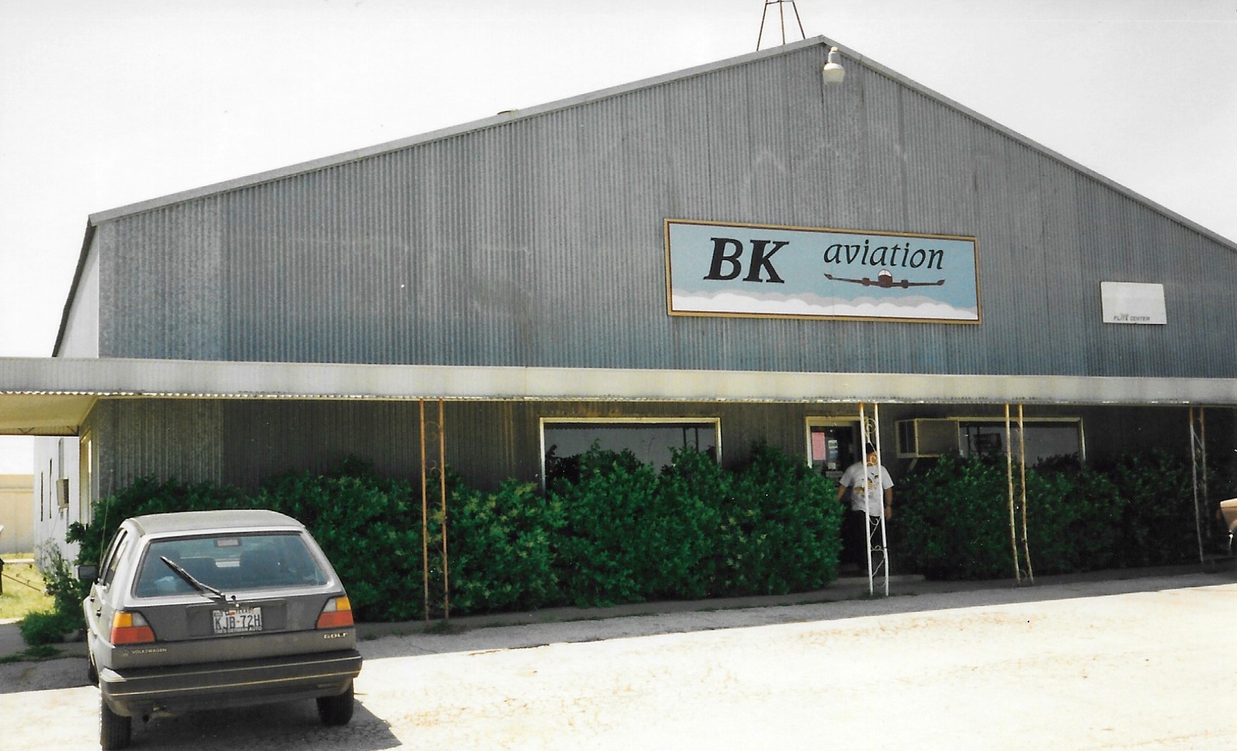
A circa 1990s photo by Patrick Mojsack of BK Aviation at Luck Field.

A circa 1990s photo by Patrick Mojsack of the interior of the BK Aviation office at Luck Field.
Patrick reported in 2020, “Bill Knight is a family friend & he still has that sign with the same fuel prices tucked away in a corner of his current hangar.”
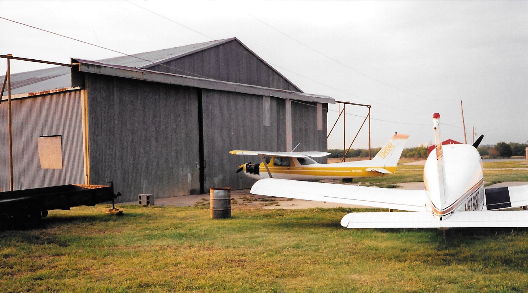
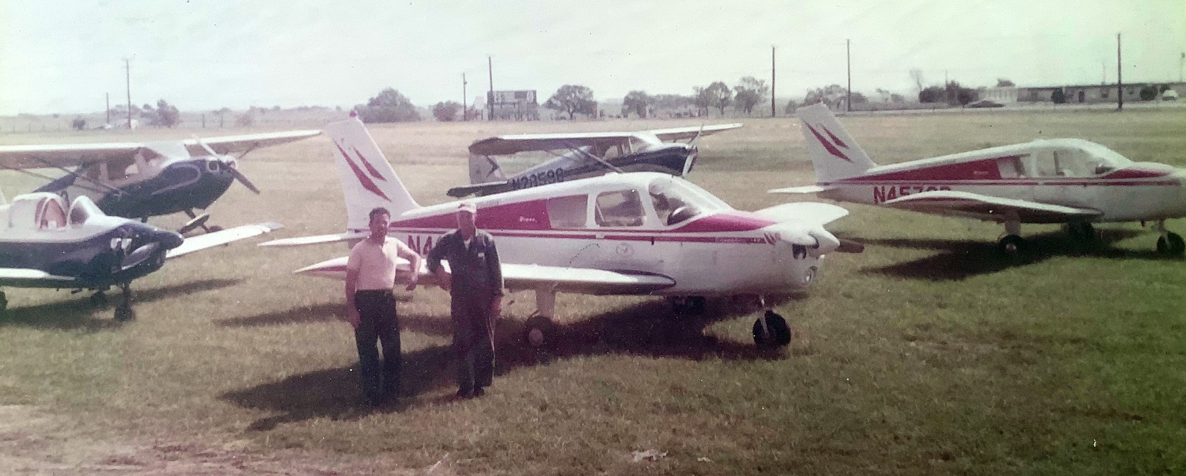
A circa 1990s photo by Patrick Mojsack of a Cessna 152 & a Piper in front of a Luck Field hangar.
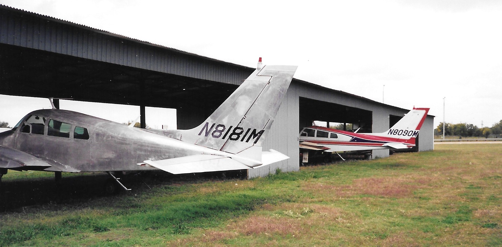
A circa 1990s photo by Patrick Mojsack of 2 twin Cessnas under a Luck Field shade hangar.
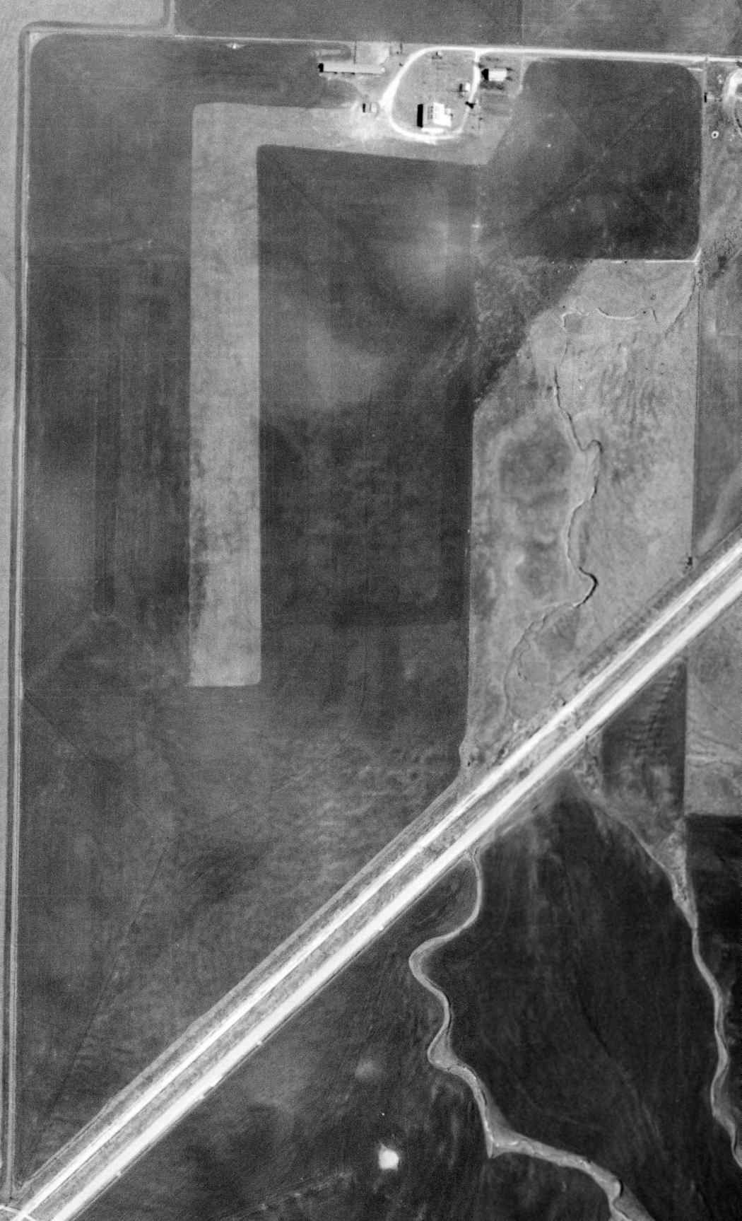
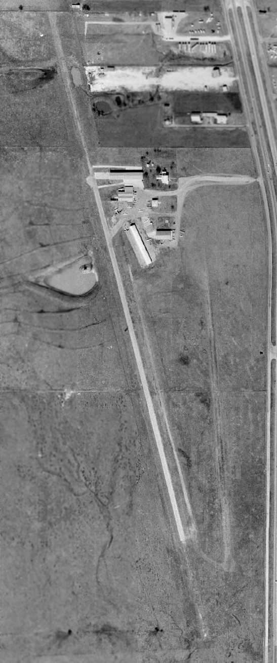
The last photo which has been located showing Luck Field while still in operation was a 1995 USGS aerial view looking southwest.
It appeared as if the primary runway had recently been repaved, but the grass runway was no longer apparent.
At least 3 light single-engine aircraft were visible parked on the east side of the field.
The last aeronautical chart depiction which has been located of Luck Field was on the October 1998 DFW Terminal Aeronautical Chart (courtesy of Ron Plante),
which depicted Luck as having a single north/south paved 3,500' runway.
Forth Worth area private pilot Rich Wolf reported, "Luck Field closed within a few years after Leske Luck (its owner) died."
According to Roger Mullins, “Luck was closed in the mid- to late 1990s. The airport was bought by a developer from Dallas.”
The increasing value of the property most likely played a large role in the closure of Luck Field.
It was also probably due to its proximity to other airports,
as there were a total of 3 general aviation airports located within a distance of only five miles:
Sycamore Strip to the north, Luck Field, and Oak Grove (later to become Spinks) to the south.
Unfortunately, it appeared that the local area couldn't support 3 fields in such close proximity,
particularly once the local government replaced Oak Grove Airport with the new Spinks Airport.
A sad sight for anyone who values general aviation airports:
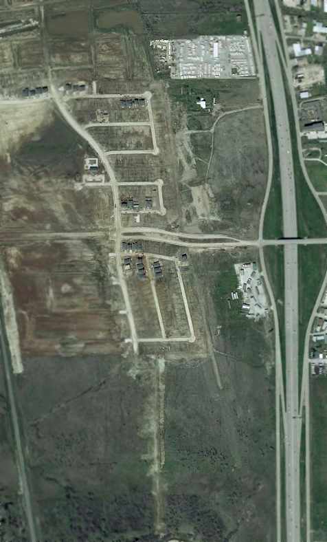
the 2001 USGS aerial photo showed that Luck Field had already been almost completely removed, with a new housing development being built over it.
Remnants of a portion of the south end of the runway were still visible.
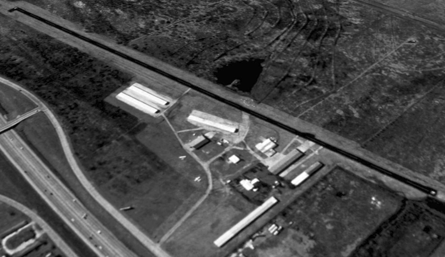
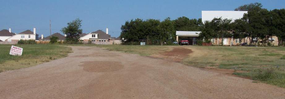
An August 2002 aerial view by Paul Freeman looking southeast at the site of the former Luck Field.
Thanks to Charlie McClure for the flight.
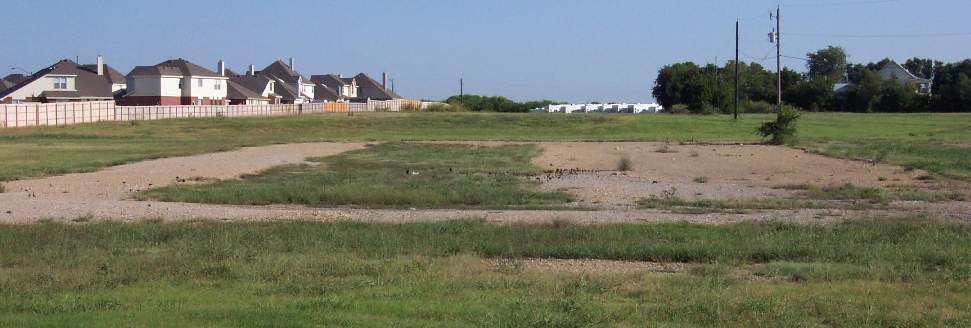
An August 2002 photo by Paul Freeman of what used to be the entrance to Luck Field, with the former airport owner's home on the right.
To the casual observer, there was no indication that an airport once stood at the site.
The former airport owner's home was the only airport building remaining on the site - all of the hangars had been removed.
A development of new homes had been built along the western portion of the airport property,
with a wall surrounding the development that roughly paralleled the former runway.
Garden Acres Drive had been extended, and crossed over the location of the former runway.
An August 2002 photo by Paul Freeman of the remains of a ramp which formerly surrounded the southern set of hangars at the former Luck Field.
Luck Field was no longer depicted on the 2004 DFW Terminal Aeronautical Chart (courtesy of Jonathan Westerling).
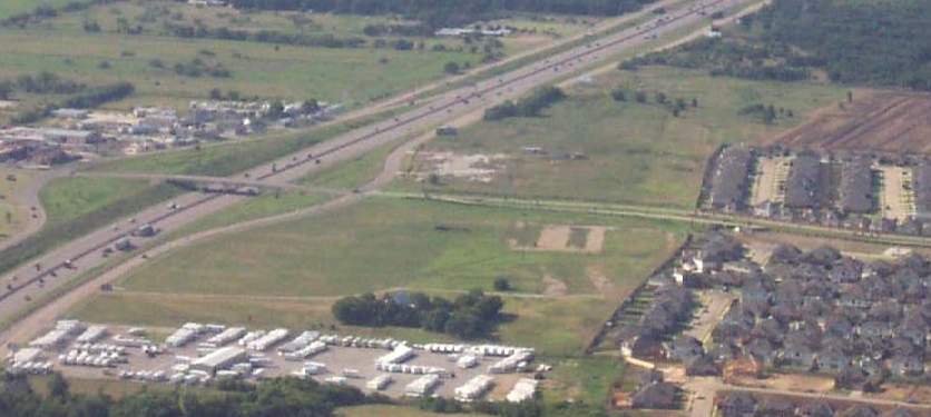
A 2017 aerial view looking southwest showed only the faintest trace of the southern portion of Luck Field's runway still recognizable.
Another of America's hundreds of grassroots general aviation airports erased from the landscape by ever-more housing.
The site of Luck Field is located west of the intersection of Interstate 35 & Garden Acres Drive.
____________________________________________________
Or if you prefer to contact me directly concerning a contribution (for a mailing address to send a check),
please contact me at: paulandterryfreeman@gmail.com
If you enjoy this web site, please support it with a financial contribution.
____________________________________________________
This site covers airfields in all 50 states.